5. Environmental Analysis
|
|
|
- Griffin O’Brien’
- 5 years ago
- Views:
Transcription
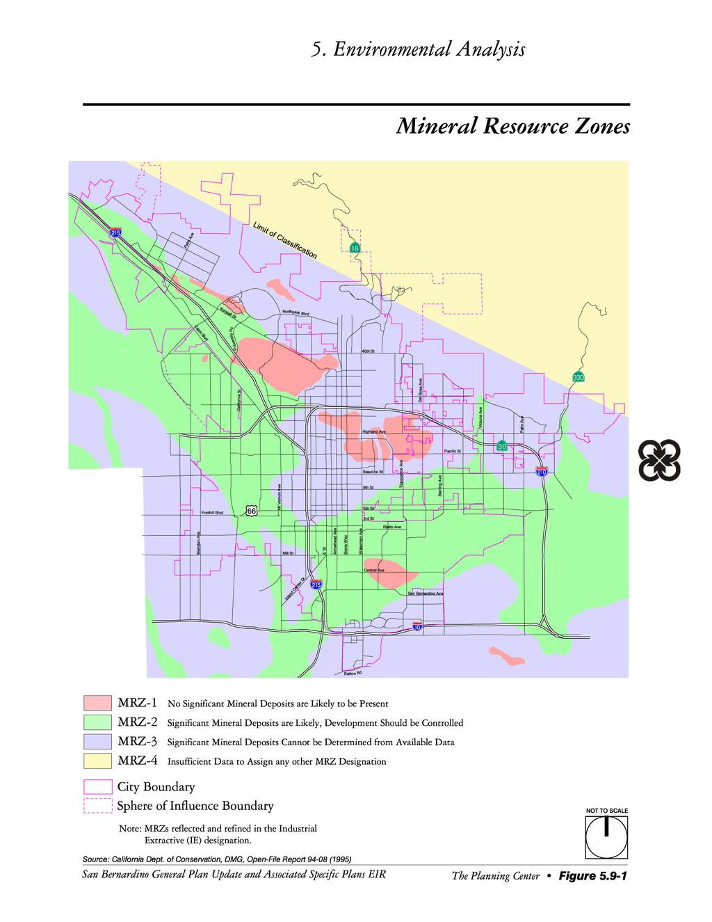
1 5.9 MINERAL RESOURCES This section of the EIR evaluates the potential for implementation of the City of San Bernardino General Plan Update, and the Arrowhead Springs Specific Plan to impact mineral resources in the City San Bernardino and its Sphere of Influence (SOI). This document focuses on those issues determined to be potentially significant as described in the Initial Study completed for this project (See Appendix A). The analysis in this section is based in part on the following technical report(s): City of San Bernardino General Plan, Envicom Corporation, Adopted June 2, 1989, DMG Open-File Report 94-08, Department of Conservation, Division of Mines and Geology, 1995 Minerals are defined as any naturally occurring chemical elements or compounds, formed from inorganic processes and organic substances. Minable minerals or an "ore deposit" is defined as a deposit of ore or mineral having a value materially in excess of the cost of developing, mining and processing the mineral and reclaiming the project area. Mineral resources are an integral part of development and economic well-being of a city or county. The wise conservation, extraction and processing of those mineral resources is essential to meeting the needs of society. Mineral deposits are important to many industries, including construction, transportation, and chemical processing. The first mineral commodity selected by the State Mining and Geology Board for classification by the State Geologist was construction aggregate-sand, gravel, and crushed rock. The value of mineral deposits is enhanced by their close proximity to urban areas; however, these mineral deposits are endangered by the same urbanization that enhances their value. The non-renewable characteristic of mineral deposits necessitates the careful and efficient development of mineral resources to prevent the unnecessary waste of these deposits due to careless exploitation and uncontrolled urbanization. Mineral Resource Classification The California Geological Survey Mineral Resources Project provides information about California s non-fuel mineral resources. The Mineral Resources Project classifies lands throughout the State that contain regionally significant mineral resources as mandated by the Surface Mining and Reclamation Act (SMARA) of Non-fuel mineral resources include metals such as gold, silver, iron, and copper; industrial metals such as boron compounds, rare-earth elements, clays, limestone, gypsum, salt and dimension stone; and construction aggregate including sand, gravel, and crushed stone. Development generally results in a demand for minerals, especially construction aggregate. The presence or absence of significant sand, gravel, or stone deposits that are suitable sources of aggregate are classified as Mineral Resource Zones (MRZs), as described below. The intent of classification is to assist lead agencies, planners, and the public in the wise use, management, and conservation of California s mineral resources. As California s population continues to expand, the demand for minerals, especially building construction such as aggregates, will similarly grow. MRZ-1 A Mineral Resource Zone where adequate information indicates that no significant mineral deposits are present or likely to be present. MRZ-2 A Mineral Resource Zone where adequate information indicates that significant mineral deposits are present, or a likelihood of their presence and development should be controlled. MRZ-3 A Mineral Resource Zone where the significance of mineral deposits cannot be determined from the available data. General Plan Update and Associated Specific Plans EIR City of San Bernardino Page 5.9-1
2 MRZ-4 A Mineral Resource Zone where there is insufficient data to assign any other MRZ designation Environmental Setting San Bernardino General Plan The City of San Bernardino lies on a broad, gently sloping lowland that flanks the southwest margin of the San Bernardino Mountains. The lowland is underlain by alluvial sediments eroded from bedrock in the adjacent mountains and washed by rivers and creeks into the valley region where they have accumulated in layers of gravel, sand, silt and clay. Sediment accumulation has continued for a few million years, during which time increasing thicknesses of sediments have gradually buried the original hill and valley topography of the Bunker Hill-San Timoteo Basin. Shandin Hills and other smaller hill areas in the basin are remnants of the original topography. The San Bernardino Mountains, Shandin Hills, and other hilly areas are comprised predominantly of Mesozoic and older crystalline basement terrain. Younger sedimentary deposits consist of late Pleistocene alluvium outcropping on the older alluvial fans northeast of the City, and underlying the younger Holocene alluvium of the San Bernardino Valley. These younger sediments accumulated in two different depositional environments. Alluvial fans that extend downslope from the mouths of the San Bernardino Mountain canyons consist of coarser grained and more poorly sorted boulders, cobbles, gravels, sands, silts and clays that decrease in size and abundance to the southwest. Floodplain deposits from the Santa Ana River and Cajon and Lytle Creeks in the vicinity of metropolitan San Bernardino are comprised predominantly of sand, sandy silt, and silt. The alluvial fan and floodplain deposits interfinger and form a highly variable and often times laterally discontinuous layering of various sizes of alluvial materials. The sediments accumulated in the alluvial fans and floodplain deposits described above have been classified by the California Department of Conservation, Division of Mines and Geology. In the San Bernardino City area, the bulk of construction aggregate is found in the natural sand and gravel deposits of Cajon Wash, Lytle Creek, Warm Creek, City Creek, and the Santa Ana River. Figure depicts the MRZs as described earlier for the City of San Bernardino and its SOI and as classified in the 1995 California Department of Conservation, Division of Mines and Geology Open-File Report (CDC-DMG). The primary goal of mineral resource classification is to identify regionally significant mineral deposits in an effort to conserve and develop them for anticipated aggregate production needs of the region. The remainder of the City is designated as MRZ-1 MRZ-3 and MRZ-4 zones. The State of California designates a large meandering swath of MRZ-2 area predominately near the western and southern City boundaries. The MRZ-2 areas indicate the existence of construction aggregate deposits that meet certain State criteria for value and marketability based solely on geologic factors. By statute, the Board does not utilize existing land uses as a criterion in its classification of Mineral Resource Zones. This may often result in the classification of MRZs which are already developed in a variety of uses and intensities, rendering these areas unsuitable for mineral production. However, additional State studies in San Bernardino include the criteria of existing land use. This helps identify resource sectors that contain aggregate resources which remain potentially available from a land use perspective. The regionally significant construction aggregate sectors within City planning areas are depicted in Figure Private lands within the City limit that are part of the significant construction aggregate sectors are designated IE, Industrial Extractive and IH, Industrial Heavy, to facilitate mineral resource development. Page The Planning Center July 2005
3
4 This page intentionally left blank. Page The Planning Center July 2005
5
6 This page intentionally left blank. Page The Planning Center July 2005
7 The presence of resource sectors require that a General Plan show the location of the sectors and incorporate policies for the management of their mineral resources. If a city proposes a land use that is incompatible with mineral extraction in or near resource sectors, it must reveal why the mineral resource is not being protected. In 1985, the City of San Bernardino requested deletion of 12 of their 31 designated Mineral Resource Sectors. Since that time, at least five of the sectors had been deleted by the State, and seven sectors were still being opposed by the City for mineral resource designation (Figure 5.9-2) Arrowhead Springs Specific Plan The Arrowhead Springs planning area is located in the northeastern portion of the San Bernardino planning area. Generally, the Arrowhead Springs Specific Plan area has the same geological setting as the City of San Bernardino as they are interconnected. However, while the City lies mainly at the base of the steeper slopes of the San Bernardino Mountains, the Arrowhead Springs planning area extends up the flank of the San Bernardino Mountains. The Arrowhead Springs Specific Plan area lies at an elevation of 1,480 feet to 2,400 feet above mean sea level (msl). Arrowhead Springs is located in the Waterman Canyon and East Twin Creek Watersheds and three primary water courses flow through the planning area: the East Twin Creek; Strawberry Creek; and West Twin Creek which flows through Waterman Canyon. The Arrowhead Springs planning area can be described as hilly marked with sharp terrain, valleys, and inaccessible steep slopes of the San Bernardino Mountains. In general the Arrowhead Springs Specific Plan area consists of numerous canyons primarily facing south. Within areas of the upper plateau and ridges, near the south, the subgrade soils are comprised of moderately dense, deeply weathered gravely sand with some silts. Within the upper plateau and hillsides near the north, subgrades are expected to consist of grayish brown to gray highly fractured metamorphic rocks, weathered gravelly sand of decomposed granitic origin, and/or calcite as derived from old hot springs. Within the canyon bottoms, subgrade soils consist of alluviums of silty fine sand and fine to medium coarse gravelly sand of variable consistency along with numerous cobbles and isolated rocks. Subgrade soils underlying the upper described alluviums are expected to consist of well consolidated gravelly sand or weathered bedrock of siltstone/sandstone origin, generally compressible in nature. The sediments accumulated in the alluvial fans and floodplain deposits described above have been partially classified by the California Department of Conservation, Division of Mines and Geology. The Arrowhead Springs area is predominately outside the limit of aggregate classification and zoned as MRZ-4. However, the most southern portion of the area is within the limit of classification and zoned as MRZ-3. Figure indicates that the MRZ-3 zone lacks adequate information for the Arrowhead Springs area. The primary goal of mineral resource classification was to identify regionally significant mineral deposits in an effort to conserve and develop them for anticipated aggregate production needs of the region. The Arrowhead Springs area does not have sufficient data available to make a determination of any significant mineral deposits. According to Appendix G of the CEQA Guidelines, a project would normally have a significant effect on the environment if the project would: M-1 Result in the loss of availability of a known mineral resource that would be of value to the region and the residents of the state. M-2 Result in the loss of availability of a locally important mineral resource recovery site delineated on a local general plan, specific plan or other land use plan. General Plan Update and Associated Specific Plans EIR City of San Bernardino Page 5.9-7
8 The following impact analysis addresses thresholds of significance for which the Initial Study disclosed potentially significant impacts. The applicable thresholds are identified in parenthesis after the impact statement San Bernardino General Plan GP IMPACT 5.9-1: PROJECT IMPLEMENTATION WOULD NOT RESULT IN THE LOSS OF AVAILABILITY OF A KNOWN MINERAL RESOURCE. [THRESHOLDS M-1 AND M-2] Impact Analysis: As previously stated the City of San Bernardino further evaluated areas listed by the State as containing regionally significant construction aggregate sectors as shown on Figure and determined several sectors could not be protected due to incompatible land use and such sectors were opposed by the City. The reasons these sectors are opposed by the City include; rapid growth rate (in excess of 25 percent), identification of rare and endangered plant species, traffic and safety concerns, proximity to highly urbanized areas, inadequate freeway access, and incompatibility with surrounding land uses (lack of a adequate buffer zone). The aggregate sectors identified on Figure (not including the contested areas) all fall within Public Flood Control or Industrial land use designations where mineral extraction is an allowed use and thus buildout of the General Plan as proposed does not represent a loss in availability of a known mineral resource. Relevant General Plan Policies and Programs The following are City of San Bernardino General Plan policies and programs related to mineral resources: Natural Resources Element Policy : Continue to document current extraction sites, including sand and gravel quarries, including the status and duration of existing permits and approvals. Policy : Impose conditions and enforce mitigation measures on mining operations to reduce dust, noise, and safety hazards associated with removal of construction aggregate and minimize impacts on adjacent properties and environmental resources. Policy : Determine and designate approved access routes to and from mineral resource sectors to minimize the impacts to vehicular circulation on City streets. Policy : Require that any applications to permit uses other than mineral extraction or the interim uses defined in areas designated IE, Industrial Extractive include findings to be prepared by the project proponent outlining the reasons why mining is not a feasible use and how the deletion of the area as a potential mineral resource supply impacts the regional supply of aggregate resources. Policy : Require that the operation and reclamation of surface mines be consistent with the State Surface Mining and Reclamation Act (SMARA) and the Development Code. Policy : Designate post aggregate extraction reclamation procedures to mitigate potential environmental impacts and safety hazards. Long-term monitoring of the effectiveness of the reclamation procedures should be considered as an integral part of the program. Policy : Restrict incompatible land uses within the impact area of existing or potential surface mining areas. Page The Planning Center July 2005
9 Policy : Require that new, non-mining land uses adjacent to existing mining operations be designed to provide a buffer between the new development and the mining operations. The buffer distance shall be based on an evaluation of noise, aesthetics, drainage, operating conditions, biological resources, topography, lighting, traffic, operating hours, and air quality Arrowhead Springs Specific Plan AHS IMPACT 5.9-1: PROJECT IMPLEMENTATION WOULD NOT RESULT IN THE LOSS OF AVAILABILITY OF A KNOWN MINERAL RESOURCE. [THRESHOLDS M-1 AND M-2] Impact Analysis: The Arrowhead Springs area is predominately outside the limit of aggregate classification and zoned as MRZ-4. However, the most southern portion of the area is within the limit of classification and zoned as MRZ-3. The area of Arrowhead Springs is not considered likely to contain significant sources of mineral resources. Furthermore due to its mountainous terrain and limited access roads pockets of aggregates which may be in the low lying stream bed areas are not likely to be economically viable. Additionally the MWD pipeline would preclude mining in areas where it is located. There are currently no aggregate mining activities in the area. At this time there is no evidence of economically viable mineral resources within the area and development pursuant to the Specific Plan is not anticipated to result in loss of significant resources. However, the future economic feasibility of mining any of the MRZ-3 or MRZ-4 resources would depend on future market conditions and the resource availability within the productionconsumption area. The intent of SMARA is to promote production and conservation of mineral resources, minimize environmental effects of mining and to ensure that mined lands will be reclaimed to conditions suitable for alternative uses. The act mandates a two-phased mineral resources process called classification-designation. The California Division of Mines and Geology is responsible for the classification phase of the process and the State Mining and Geology Board is responsible for designating areas of significance that are known to contain significant mineral deposits. This objective of providing the information is to provide a basis for local land use decision makers in which the availability of the mineral resource is acknowledged. California aggregate companies are heavily regulated and must meet the requirements of up to 80 agencies overseeing federal, state, county, and local laws. Regulations cover environmental, technical, health and safety, aesthetic, cultural, land use, and reclamation standards. Obtaining an operating permit is both intensive and extensive, involving in-depth studies and thorough data compilation. Consulting with communities, regulatory agencies, government officials, and all other interested or affected stakeholders is an equally important procedure. The permitting process often takes from 2-10 years to complete, includes substantial up-front investment by the company, and offers no guarantee of project approval. Once the permit is granted, the regulatory process continues throughout the life of the operation with continued submission of data, and inspections. Upon implementation of project design features, regulatory requirements, and standard conditions of approval, the following impacts would be less than significant: GP Impact The aggregate sectors identified by the State fall within use designations where mineral extraction is an allowed use; thus build-out of the General Plan as proposed does not represent a loss in availability of a known mineral resource. General Plan Update and Associated Specific Plans EIR City of San Bernardino Page 5.9-9
10 AHS Impact Although not specifically identified by the State, the Arrowhead Springs Specific Plan area is not likely to yield economically significant aggregate sectors due to mountainous terrain and preexisting uses San Bernardino General Plan No significant impacts were identified and no mitigation measures are necessary Arrowhead Springs Specific Plan No significant impacts were identified and no mitigation measures are necessary. No significant adverse impacts relating to mineral resources were identified and no mitigation measures are necessary. Page The Planning Center July 2005
5. Environmental Analysis
 5.11 This section of the Draft Environmental Impact Report (DEIR) evaluated potential impacts to mineral resources from implementation of the General Plan. 5.11.1 Environmental Setting Minerals are defined
5. Environmental Analysis
 5.9 MINERAL RESOURCES 5.9.1 Methodology The California Geological Survey Mineral Resources Project provides information about California s nonfuel mineral resources. The primary focus of the Mineral Resources
5.11 MINERAL RESOURCES
 5.11 This section of the Draft PEIR evaluates the potential impacts to mineral resources in the Plan Area from implementation of the Clovis General Plan and Development Code Update (proposed project).
4.12 Mineral Resources
 4.12.1 Setting Section 2.2, Project Location, provides general information about the Project s regional and local setting. This Section 4.12.1 provides setting information specific to mineral resources.
PRELIMINARY WORKING DRAFT Work in Progress
 IV. ENVIRONMENTAL IMPACT ANALYSIS H. MINERAL RESOURCES 1.0 INTRODUCTION This section addresses the potential impacts of the Proposed Project on mineral resources (i.e., sand, gravel and petroleum). The
Mineral Resources
 Sacramento Local Agency Formation Commission Mineral Resources 3.11 - Mineral Resources 3.11.1 - Introduction This section describes and evaluates potential environmental impacts to mineral resources resulting
Michigan s Geology and Groundwater
 Michigan s Geology and Groundwater Ralph J. Haefner Deputy Director U.S. Geological Survey Michigan-Ohio Water Science Center Lansing, Michigan Outline About the USGS Geology 101 Michigan s geology Bedrock
GEOLOGY AND SOILS. This chapter summarizes geologic and geotechnical aspects of the site as they relate to the Project.
 9 GEOLOGY AND SOILS INTRODUCTION This chapter summarizes geologic and geotechnical aspects of the site as they relate to the Project. This chapter utilizes information from the following reports prepared
3.8 Geology/Soils. Environmental Setting. Topography. Geology and Soils
 3.8 Geology/Soils This section examines whether implementation of the 2004 Land Use Mobility Elements, Zoning Code Revisions, and Central District Specific Plan the will expose people or structures to
Impact : Changes to Existing Topography (Less than Significant)
") 4.2 Land Resources 4.2.1 Alternative A Proposed Action Impact 4.2.1-1: Changes to Existing Topography (Less than Significant) Development of the project site would involve grading and other earthwork as
4.2 Land Resources 4.2.1 Alternative A Proposed Action Impact 4.2.1-1: Changes to Existing Topography (Less than Significant) Development of the project site would involve grading and other earthwork as
4.5 GEOLOGY, SOILS AND SEISMICITY
 4.5 This section summarizes information on geology, soils and seismic hazards, and mineral resources in the Truckee area, as well as potential area-wide geologic hazards and regional seismic characteristics
4.5 GEOLOGY AND SOILS
 4.5.1 Setting 4.5 GEOLOGY AND SOILS a. Regional Geology. The is located in the south central Santa Cruz Mountains in the heart of the Central Coast ranges of California. This is a seismically active region
Section 4.14 Mineral Resources
 Section 4.14 Mineral Resources 4.14.1 Introduction Minerals are defined as any naturally occurring chemical elements or compounds formed from inorganic processes and organic substances. Minable minerals
9. GEOLOGY, SOILS, AND MINERALS
 June 28, 2018 Page 9-1 9. GEOLOGY, SOILS, AND MINERALS This EIR chapter describes the existing geological, soil, and mineral conditions in the planning area. The chapter includes the regulatory framework
TABLE OF CONTENTS LIST OF FIGURES. Figure : Mineral Resource Zone Map of the Proposed Project LIST OF TABLES
 TABLE OF CONTENTS 4.11 MINERAL RESOURCES... 4.11-1 4.11.0 Introduction... 4.11-1 4.11.1 Methodology... 4.11-1 4.11.2 Existing Conditions... 4.11-2 4.11.3 Impacts... 4.11-6 4.11.4 Applicants-Proposed Measures...
NOA ASSESSMENT HARRIS QUARRY MENDOCINO COUNTY, CALIFORNIA TABLE OF CONTENTS
 NOA ASSESSMENT HARRIS QUARRY MENDOCINO COUNTY, CALIFORNIA TABLE OF CONTENTS Introduction... 1 Scope of Services... 1 Project Location and Description... 1 Geologic Setting... 1 Regional Geology... 1 Site
5.11 Geology and Soils
 5.11 Geology and Soils 5.11 GEOLOGY AND SOILS This section evaluates the geologic and seismic conditions within the City of Azusa and evaluates the potential for geologic hazard impacts associated with
IV. ENVIRONMENTAL IMPACT ANALYSIS E. GEOLOGY/SOILS
 IV. ENVIRONMENTAL IMPACT ANALYSIS E. GEOLOGY/SOILS Except where otherwise noted, the following Section is based on the Preliminary Geotechnical Investigation, Proposed Medical Office Buildings and Mixed-Use
1.0 PURPOSE AND FORMAT OF THE FINAL EIR
 1.0 PURPOSE AND FORMAT OF THE FINAL EIR 1.1 PROJECT OVERVIEW CEMEX (RMC Pacific Materials, dba CEMEX) operates the Bonny Doon Shale and Limestone Quarries in Santa Cruz County for the production of Portland
IV. ENVIRONMENTAL IMPACT ANALYSIS G. GEOLOGY AND SOILS
 IV. ENVIRONMENTAL IMPACT ANALYSIS G. GEOLOGY AND SOILS The following section is a summary of the geotechnical report conducted for the proposed project. The Report of Geotechnical Investigation Proposed
IV. ENVIRONMENTAL IMPACT ANALYSIS E. GEOLOGY AND SOILS
 IV. ENVIRONMENTAL IMPACT ANALYSIS E. GEOLOGY AND SOILS INTRODUCTION This section evaluates potential impacts related to geology, including seismicity, and soils associated with development of the proposed
Sediment and sedimentary rocks Sediment
 Sediment and sedimentary rocks Sediment From sediments to sedimentary rocks (transportation, deposition, preservation and lithification) Types of sedimentary rocks (clastic, chemical and organic) Sedimentary
Land subsidence due to groundwater withdrawal in Hanoi, Vietnam
 Land Subsidence (Proceedings of the Fifth International Symposium on Land Subsidence, The Hague, October 1995). 1AHS Publ. no. 234, 1995. 55 Land subsidence due to groundwater withdrawal in Hanoi, Vietnam
SURFACE GEOLOGY AND LIQUEFACTION SUSCEPTIBILITY IN THE INNER RIO GRANDE VALLEY NEAR ALBUQUERQUE, NEW MEXICO
 SURFACE GEOLOGY AND LIQUEFACTION SUSCEPTIBILITY IN THE INNER RIO GRANDE VALLEY NEAR ALBUQUERQUE, NEW MEXICO Keith I. Kelson, Christopher S. Hitchcock, and Carolyn E. Randolph William Lettis & Associates,
SL GEOLOGY AND MINING. Coal bearing strata in the project area are referable primarily to the Allegheny Group of
 SL-145-1 GEOLOGY AND MINING Coal bearing strata in the project area are referable primarily to the Allegheny Group of Pennsylvania age. These rocks occur as dissected remnants overlying the ridge-forming
EROSION, DEPOSITION AND SEDIMENTARY ROCKS. Reading: Earth Science Tarbuck and Lutgens Chapter 5: pages Chapter 3: pages 52-54, 61-69
 EROSION, DEPOSITION AND SEDIMENTARY ROCKS Reading: Earth Science Tarbuck and Lutgens Chapter 5: pages 124-133 Chapter 3: pages 52-54, 61-69 Base Level Resistant bed Resistant bed creates a local base level
Cuyama Basin North Fork Vineyard
 Cuyama Basin North Fork Vineyard Company Background plus Data Insights to Support GSP Development for the Cuyama Basin Presented by Grapevine Capital Partners and Cleath-Harris Geologists April 26th, 2018
IV. ENVIRONMENTAL IMPACT ANALYSIS E. GEOLOGY AND SOILS
 IV. ENVIRONMENTAL IMPACT ANALYSIS E. GEOLOGY AND SOILS The following section is a summary of the geotechnical report conducted for the Proposed Project. The Geotechnical Engineering Investigation (the
ENGINEERING EVALUATION OF THE STANLEY MINE ADVENTURE PARK AREA CLEAR CREEK COUNTY, COLORADO. Prepared for:
 braun Braun Consulting Engineers ENGINEERING EVALUATION OF THE STANLEY MINE ADVENTURE PARK AREA CLEAR CREEK COUNTY, COLORADO Prepared for: STANLEY MINES ADENTURE PARK 3375 W. POWERS CIRCLE LITTLETON, COLORADO
Lab 7: Sedimentary Structures
 Name: Lab 7: Sedimentary Structures Sedimentary rocks account for a negligibly small fraction of Earth s mass, yet they are commonly encountered because the processes that form them are ubiquitous in the
Chapter 7 Mudflow Analysis
 Chapter 7 Mudflow Analysis 7.0 Introduction This chapter provides information on the potential and magnitude of mud floods and mudflows that may develop in Aspen due to rainfall events, snowmelt, or rain
Evolution of the conceptual hydrogeologic and ground-water flow model for Las Vegas Valley, Clark County, Nevada
 Evolution of the conceptual hydrogeologic and ground-water flow model for Las Vegas Valley, Clark County, Nevada Geological Society of America Annual Meeting November 14, 2 David J. Donovan Southern Nevada
Hydrogeological Assessment for Part of Lots 2 and 3, Concession 5, Township of Thurlow, County of Hastings 1.0 INTRODUCTION. 1.
 February 10,2017 25506400 Ontario Ltd. Foxboro, ON Attention: Brad Newbatt Re: Hydrogeological Assessment for Part of Lots 2 and 3, Concession 5, Township of Thurlow, County of Hastings 1.0 INTRODUCTION
UNIT 4 SEDIMENTARY ROCKS
 UNIT 4 SEDIMENTARY ROCKS WHAT ARE SEDIMENTS Sediments are loose Earth materials (unconsolidated materials) such as sand which are transported by the action of water, wind, glacial ice and gravity. These
KANSAS GEOLOGICAL SURVEY Open File Report LAND SUBSIDENCE KIOWA COUNTY, KANSAS. May 2, 2007
 KANSAS GEOLOGICAL SURVEY Open File Report 2007-22 LAND SUBSIDENCE KIOWA COUNTY, KANSAS Prepared by Michael T. Dealy L.G., Manager, Wichita Operations SITE LOCATION The site was approximately four miles
Chapter 7 Mudflow Analysis
 Chapter 7 Mudflow Analysis 7.0 Introduction This chapter provides information on the potential and magnitude of mud floods and mudflows that may develop in Aspen due to rainfall events, snowmelt, or rain
Connecticut's Aquifers
 Page 1 of 5 DEP Search: Connecticut's Aquifers The technical definition of the word "aquifer" is: any geologic formation capable of yielding significant quantities of water to wells. By that definition,
Hydraulic Impacts of Limestone Quarries and Gravel Pits. Jeff Green Minnesota DNR-Division of Ecological & Water Resources
 Hydraulic Impacts of Limestone Quarries and Gravel Pits Jeff Green Minnesota DNR-Division of Ecological & Water Resources The Hydraulic Impacts of Limestone Quarries and Gravel Pits Study was funded by
Weathering, Erosion, Deposition, and Landscape Development
 Weathering, Erosion, Deposition, and Landscape Development I. Weathering - the breakdown of rocks into smaller particles, also called sediments, by natural processes. Weathering is further divided into
Ecoregions Glossary. 7.8B: Changes To Texas Land Earth and Space
 Ecoregions Glossary Ecoregions The term ecoregions was developed by combining the terms ecology and region. Ecology is the study of the interrelationship of organisms and their environments. The term,
Starting at Rock Bottom
 Starting at Rock Bottom At rock bottom of the Brushy Creek site s geological column lies the first clue to human habitation: A smelting and heattreating furnace, and mold, carved into Bed Ked: Figure 15
IV. ENVIRONMENTAL IMPACT ANALYSIS G. GEOLOGY AND SOILS
 IV. ENVIRONMENTAL IMPACT ANALYSIS G. GEOLOGY AND SOILS The following section is based upon the City of El Segundo General Plan and General Plan EIR and addresses the following geologic issues: soil erosion,
2 Aggregates in Indiana
 2 Aggregates in Indiana Origin of Aggregates Gravel and Natural Sands Crushed Stone Slag Distribution of Aggregates Glacial Deposits Bedrock Deposits Aggregate Types Natural Aggregates Artificial Aggregates
abrasion the rubbing, grinding, and bumping of rocks that cause physical weathering (SRB, IG)
") FOSS Soils, Rocks, and Landforms Module Glossary NGSS Edition 2019 abrasion the rubbing, grinding, and bumping of rocks that cause physical weathering (SRB, IG) acid a substance that geologists use to
FOSS Soils, Rocks, and Landforms Module Glossary NGSS Edition 2019 abrasion the rubbing, grinding, and bumping of rocks that cause physical weathering (SRB, IG) acid a substance that geologists use to
4.5 GEOLOGY AND SOILS
 4.5 GEOLOGY AND SOILS This section addresses the project site geology and soils and analyzes potential changes that would result from development of the Wye Specific Plan project. 4.5.1 Environmental Setting
Cattaraugus Creek: A Story of Flowing Water and the Geology of the Channel It Flows Through Presentation to West Valley Citizen Task Force 4/27/16
 Cattaraugus Creek: A Story of Flowing Water and the Geology of the Channel It Flows Through Presentation to West Valley Citizen Task Force 4/27/16 Raymond C. Vaughan, Ph.D. What happens if you drop a
HISTORY OF CONSTRUCTION FOR EXISTING CCR SURFACE IMPOUNDMENT PLANT GASTON ASH POND 40 CFR (c)(1)(i) (xii)
(1)(i) (xii)") HISTORY OF CONSTRUCTION FOR EXISTING CCR SURFACE IMPOUNDMENT PLANT GASTON ASH POND 40 CFR 257.73(c)(1)(i) (xii) (i) Site Name and Ownership Information: Site Name: E.C. Gaston Steam Plant Site Location:
HISTORY OF CONSTRUCTION FOR EXISTING CCR SURFACE IMPOUNDMENT PLANT GASTON ASH POND 40 CFR 257.73(c)(1)(i) (xii) (i) Site Name and Ownership Information: Site Name: E.C. Gaston Steam Plant Site Location:
The last three sections of the main body of this report consist of:
 Threatened and Endangered Species Geological Hazards Floodplains Cultural Resources Hazardous Materials A Cost Analysis section that provides comparative conceptual-level costs follows the Environmental
Appendix G. Summary of Hydrogeologic Conditions and Historical Mining Northwest of the Centro Subarea in the Randsburg, Red Mountain, and Atolia Area
 Appendix G Summary of Hydrogeologic Conditions and Historical Mining Northwest of the Centro Subarea in the Randsburg, Red Mountain, and Atolia Area 1.1 Background This appendix provides a summary of hydrogeologic
STUDY GUIDE FOR CONTENT MASTERY. Surface Water Movement
 Surface Water SECTION 9.1 Surface Water Movement In your textbook, read about surface water and the way in which it moves sediment. Complete each statement. 1. An excessive amount of water flowing downslope
4.5 GEOLOGY AND SEISMICITY
 4.5 GEOLOGY AND SEISMICITY INTRODUCTION This section identifies the potential for geologic and seismic hazards to occur on or near the proposed project site. Issues of concern include suitability of soil
GOAL 7 AREAS SUBJECT TO NATURAL DISASTERS AND HAZARDS. To protect life and property from natural disasters and hazards.
 GOAL 7 AREAS SUBJECT TO NATURAL DISASTERS AND HAZARDS A. GOALS: To protect life and property from natural disasters and hazards. B. POLICIES: 1. Floodplains shall be maintained as natural drainage-ways.
mountain rivers fixed channel boundaries (bedrock banks and bed) high transport capacity low storage input output
 high transport capacity low storage input output") mountain rivers fixed channel boundaries (bedrock banks and bed) high transport capacity low storage input output strong interaction between streams & hillslopes Sediment Budgets for Mountain Rivers Little
mountain rivers fixed channel boundaries (bedrock banks and bed) high transport capacity low storage input output strong interaction between streams & hillslopes Sediment Budgets for Mountain Rivers Little
Laboratory Exercise #4 Geologic Surface Processes in Dry Lands
 Page - 1 Laboratory Exercise #4 Geologic Surface Processes in Dry Lands Section A Overview of Lands with Dry Climates The definition of a dry climate is tied to an understanding of the hydrologic cycle
Module 10: Resources and Virginia Geology Topic 4 Content: Virginia Geology Notes
 Virginia is composed of a very diverse landscape that extends from the beaches and barrier islands all of the way to the highly elevated Appalachian Plateau. Geologists have discovered ancient shallow
The Soils and Land Capability for Agriculture. Land North of Aberdeen, Aberdeenshire
 The Soils and Land Capability for Agriculture Of Land North of Aberdeen, Aberdeenshire Report prepared for Peter Radmall Associates May 2012 Reading Agricultural Consultants Ltd Beechwood Court, Long Toll,
5. Environmental Analysis
 5.3 GEOLOGY AND SOILS The potential geology and soils impacts associated with development within The Platinum Triangle have been fully analyzed in two previous EIRs, including: Anaheim Stadium Area Master
Chapter 6 Pages of Earth s Past: Sedimentary Rocks
 Chapter 6 Pages of Earth s Past: Sedimentary Rocks Introduction! Drilling into the bottom of the North Sea, we encounter: " Soft mud and loose sand, silt, pebbles, and shells. Then: " Similar materials
Subsurface Geology of the Kennebec River
 Maine Geologic Facts and Localities July, 1998 Subsurface Geology of the Kennebec River 43 54 40.75 N, 69 48 29.01 W Text by Daniel B. Locke, Department of Agriculture, Conservation & Forestry 1 Map by
Mineral Formation & Mining
 Words Worth Knowing Pluton Pegmatite Limestone Ore Mining Mineral Formation & Mining Take notes using pages 11 and 13 in your ISN all RED words must be in notes 1 How do minerals form? Magma Plutons Magma
3.8 Mineral Resources
 Bureau of Land Management/County of Kern This section discusses mineral resources relevant to the proposed Alta East Wind Project (AEWP). The study area addressed in this section includes lands that may
For Sale - 56 Acre Sandstone Quarry State Route 511, Oberlin/Kipton, OH 44075
 14647 State Route 511, Oberlin/Kipton, OH 44075 56 ACRES Vermilion Rd Gifford Rd Haigh Rd 44 Summary The Kipton sandstone quarry is included in 56 acre tract owned by Terry A. Johnson, of Huron, Ohio.
Vermont Stream Geomorphic Assessment. Appendix E. River Corridor Delineation Process. VT Agency of Natural Resources. April, E0 - April, 2004
 Vermont Stream Geomorphic Assessment Appendix E River Corridor Delineation Process Vermont Agency of Natural Resources - E0 - River Corridor Delineation Process Purpose A stream and river corridor delineation
Surface Water and Stream Development
 Surface Water and Stream Development Surface Water The moment a raindrop falls to earth it begins its return to the sea. Once water reaches Earth s surface it may evaporate back into the atmosphere, soak
Big Rivers Electric Corporation Disposal of Coal Combustion Residuals (CCR) from Electric Utilities Final Rule CCR Impoundment Liner Assessment Report
 from Electric Utilities Final Rule CCR Impoundment Liner Assessment Report") Big Rivers Electric Corporation Disposal of Coal Combustion Residuals (CCR) from Electric Utilities Final Rule CCR Impoundment Liner Assessment Report CCR Surface Impoundment Information Name: Operator:
Big Rivers Electric Corporation Disposal of Coal Combustion Residuals (CCR) from Electric Utilities Final Rule CCR Impoundment Liner Assessment Report CCR Surface Impoundment Information Name: Operator:
J.H. Campbell Generating Facility Pond A - Location Restriction Certification Report
 J.H. Campbell Generating Facility Pond A - Location Restriction Certification Report Pursuant to: 40 CFR 257.60 40 CFR 257.61 40 CFR 257.62 40 CFR 257.63 40 CFR 257.64 Submitted to: Consumers Energy Company
LESSONS LEARNED FROM MINING-INFLUENCED WATERS STUDIES AT THE NEW MEXICO BUREAU OF GEOLOGY AND MINERAL RESOURCES
 LESSONS LEARNED FROM MINING-INFLUENCED WATERS STUDIES AT THE NEW MEXICO BUREAU OF GEOLOGY AND MINERAL RESOURCES Virginia T. McLemore New Mexico Bureau of Geology and Mineral Resources New Mexico Institute
Abrasion: The physical weathering of rocks by particles rubbing against each other.
 FOSS Earth History Course Glossary (10-4-04) Abrasion: The physical weathering of rocks by particles rubbing against each other. Absolute age: The exact age of an object (such as a rock or artifact); found
Starting at Rock Bottom: A Peculiar Central Texas PreClovis Culture
 Starting at Rock Bottom: A Peculiar Central Texas PreClovis Culture Background Brushy Creek grades, overall, west-northwest (WNW) to east-southeast (ESE) through the easternmost portions of the central
3.12 Geology and Topography Affected Environment
 3 Affected Environment and Environmental Consequences 3.12 Geology and Topography 3.12.1 Affected Environment 3.12.1.1 Earthquakes Sterling Highway MP 45 60 Project Draft SEIS The Kenai Peninsula is predisposed
CHAPTER 7 GEOLOGY AND SOILS
 CHAPTER 7 GEOLOGY AND SOILS 7.1 General Geology of the Area Based on the Geological map compiled by Cornec (2002) the area consists of Miocene/Pleistocene deposits as seen in figure 7.1. These are geologically
THE CROOKS GAP HOUSEPIT SITE AND OTHER NEARBY MID-HOLOCENE HOUSEPITS
 Volume 56(1 ), Spring 2012 The Wyoming Archaeologist THE CROOKS GAP HOUSEPIT SITE AND OTHER NEARBY MID-HOLOCENE HOUSEPITS by Craig S. Smith Marcia Peterson INTRODUCTION This article summarizes excavation
4.3 CULTURAL RESOURCES
 4.3 CULTURAL RESOURCES This section of the EIR analyzes the proposed project s potential impacts on archaeological and paleontological resources. This analysis summarizes the findings of the Archaeological
Glacial Geology of Moose Point State Park, ME
 Geologic Site of the Month May, 2013 Glacial Geology of Moose Point State Park, Maine 44 o 25 59.18"N, 68 o 56 37.11"W Text and photos by Woodrow B. Thompson, Department of Agriculture, Conservation &
THURSTON COUNTY COMPREHENSIVE PLAN UPDATE
 THURSTON COUNTY COMPREHENSIVE PLAN UPDATE BOARD OF COUNTY COMMISSIONERS WORK SESSION JUNE 14, 2017 Land Use Natural Resources Transportation Housing Utilities Environment Economic Development Capital Facilities
Sediment. Weathering: mechanical and chemical decomposition and disintegration of rock and minerals at the surface
 Sediment Some basic terminology Weathering: mechanical and chemical decomposition and disintegration of rock and minerals at the surface Erosion: removal of weathered rock and minerals from one place to
Mineral activities within Rich County, Utah
 Natural Resources and Environmental Issues Volume 14 Bear Lake Basin Article 10 1-1-2007 Mineral activities within Rich County, Utah Patsy Palacios SJ & Jessie E Quinney Natural Resources Research Library,
Flash flood disaster in Bayangol district, Ulaanbaatar
 Flash flood disaster in Bayangol district, Ulaanbaatar Advanced Training Workshop on Reservoir Sedimentation Management 10-16 October 2007. IRTCES, Beijing China Janchivdorj.L, Institute of Geoecology,MAS
The Geology of Sebago Lake State Park
 Maine Geologic Facts and Localities September, 2002 43 55 17.46 N, 70 34 13.07 W Text by Robert Johnston, Department of Agriculture, Conservation & Forestry 1 Map by Robert Johnston Introduction Sebago
Description DESCRIPTION
 DESCRIPTION The location of the Upper James Watershed is located in northeastern South Dakota as well as southeastern North Dakota. It includes the following counties located in North Dakota Barnes, Dickey,
=%REPORT RECONNAISSANCE OF CHISHOLM LAKE PROSPECT. October 25, 1977
 =%REPORT ON FIELD RECONNAISSANCE OF CHISHOLM LAKE PROSPECT October 25, 1977 Bruce D. Vincent Imperial Oil Limited, Minerals - Coal, CALGARY, ALBERTA CHISHOLM LAKE PROSPECT Introduction The Chisholm Lake
HW #2 Landscape Travel from A to B 12,
 HW #2 Landscape 2016 Section: Name: ate: 1. ase your answer(s) to the following question(s) on the map below, which represents two bridges that cross the Green River. Letters,, and represent locations
Erosion Surface Water. moving, transporting, and depositing sediment.
 + Erosion Surface Water moving, transporting, and depositing sediment. + Surface Water 2 Water from rainfall can hit Earth s surface and do a number of things: Slowly soak into the ground: Infiltration
Section 4.6 Geology and Soils Introduction
 4.6 invisible_toc_marker County of Kern Section 4.6 Geology and Soils 4.6.1 Introduction As described in Chapter 2 of this Supplemental EIR (SEIR), an EIR was previously certified for the Alta Oak Creek
APPENDIX 3B OCCURRENCE OF SIGNIFICANT RIVER ALLUVIUM AQUIFERS IN THE PLATEAU REGION
 Plateau Region Water Plan January 2011 APPENDIX 3B OCCURRENCE OF SIGNIFICANT RIVER ALLUVIUM AQUIFERS IN THE PLATEAU REGION Occurrence of Significant River Alluvium Aquifers in the Plateau Region Prepared
Chapter 2. Wearing Down Landforms: Rivers and Ice. Physical Weathering
 Chapter 2 Wearing Down Landforms: Rivers and Ice Physical Weathering Weathering vs. Erosion Weathering is the breakdown of rock and minerals. Erosion is a two fold process that starts with 1) breakdown
2013 GEOLOGICAL ASSESSMENT REPORT SHERIDAN HILL PROPERTY
 2013 GEOLOGICAL ASSESSMENT REPORT ON THE SHERIDAN HILL PROPERTY NEW WESTMINSTER MINING DIVISION BRITISH COLUMBIA NTS 092G07 49 16 31 NORTH LATITUDE, 122 39 48 WEST LONGITUDE PREPARED FOR Sheridan Hill
ENGINEER S CERTIFICATION OF FAULT AREA DEMONSTRATION (40 CFR )
") PLATTE RIVER POWER AUTHORITY RAWHIDE ENERGY STATION BOTTOM ASH TRANSFER (BAT) IMPOUNDMENTS LARIMER COUNTY, CO ENGINEER S CERTIFICATION OF FAULT AREA DEMONSTRATION (40 CFR 257.62) FOR COAL COMBUSTION RESIDUALS
PLATTE RIVER POWER AUTHORITY RAWHIDE ENERGY STATION BOTTOM ASH TRANSFER (BAT) IMPOUNDMENTS LARIMER COUNTY, CO ENGINEER S CERTIFICATION OF FAULT AREA DEMONSTRATION (40 CFR 257.62) FOR COAL COMBUSTION RESIDUALS
4.9 GEOLOGY AND SOILS
 4.9 GEOLOGY AND SOILS 4.9.1 EXISTING CONDITIONS TOPOGRAPHY AND RELIEF Zone 40 is located in the central portion of Sacramento County. The topography of the county is represented by three physiographic
Bowen s Chemical Stability Series
 Lab 5 - Identification of Sedimentary Rocks Page - Introduction Sedimentary rocks are the second great rock group. Although they make up only a small percentage of the rocks in the earth s crust (~5%)
Unit 7.2 W.E.D. & Topography Test
 Name: Score: Unit 7.2 W.E.D. & Topography Test 1. 2. 3. 4. 5. 6. 7. 8. 9. 10. 11. 12. 13. 14. 15. 16. 17. 18. 19. 20. 21. 22. 23. 24. 25. 1. The formation of mountains is due mainly to while the destruction
PolyMet NorthMet Project
 RS 26 Draft-01 December 8, 2005 RS26 Partridge River Level 1 Rosgen Geomorphic Survey Rosgen Classification Partridge River from Headwaters to Colby Lake Prepared for PolyMet NorthMet Project December
GRAVEL INVESTIGATION AREA 9 (KIMEA PIT) SIERRA-YOYO-DESAN ROAD AREA GRAVEL INVESTIGATION NORTHEASTERN, BC. Submitted to:
 SIERRA-YOYO-DESAN ROAD AREA GRAVEL INVESTIGATION NORTHEASTERN, BC. Submitted to:") AMEC Earth & Environmental Limited 610 Richard Road, Prince George, BC Canada V2K 4L3 Tel +1 (250) 564-3243 Fax +1 (250) 562-7045 www.amec.com GRAVEL INVESTIGATION AREA 9 (KIMEA PIT) SIERRA-YOYO-DESAN
AMEC Earth & Environmental Limited 610 Richard Road, Prince George, BC Canada V2K 4L3 Tel +1 (250) 564-3243 Fax +1 (250) 562-7045 www.amec.com GRAVEL INVESTIGATION AREA 9 (KIMEA PIT) SIERRA-YOYO-DESAN
Betsy Stevenson and Allison Mohrs (Skagit County Planning and Development Services) Jenny Baker, The Nature Conservancy
 Jenny Baker, The Nature Conservancy") TC Fisher Slough Final Design and Permitting Subject: Well Review Memorandum To: From: Betsy Stevenson and Allison Mohrs (Skagit County Planning and Development Services) Jenny Baker, The ature Conservancy
TC Fisher Slough Final Design and Permitting Subject: Well Review Memorandum To: From: Betsy Stevenson and Allison Mohrs (Skagit County Planning and Development Services) Jenny Baker, The ature Conservancy
The following provides summary definitions of terms relating to mineral resources:
 4.11 MINERAL RESOURCES 4.11.1 Overview This section describes the existing conditions related to mineral resources for the proposed (TRTP). The management of mineral resources is subject to numerous laws
Section I: Multiple Choice Select the best answer to each question. Mark your final answer on the answer sheet. (1 pt each)
") Sedimentary Rocks & Surface Processes Quest Name: Earth Science 2013 Block: Date: Section I: Multiple Choice Select the best answer to each question. Mark your final answer on the answer sheet. (1 pt each)
Sedimentary Rocks & Surface Processes Quest Name: Earth Science 2013 Block: Date: Section I: Multiple Choice Select the best answer to each question. Mark your final answer on the answer sheet. (1 pt each)
3.3 CLIMATE, GEOLOGY, TOPOGRAPHY, AND SOILS CLIMATE GEOLOGY TOPOGRAPHY
 3.3 CLIMATE, GEOLOGY, TOPOGRAPHY, AND SOILS This section describes the climate, geology, topography, and soil resource characteristics of the Yolo Bypass Wildlife Area (Wildlife Area). Agricultural soil
Placer Potential Map. Dawson L and U se P lan. Jeffrey Bond. Yukon Geological Survey
 Placer Potential Map Dawson L and U se P lan By Jeffrey Bond Yukon Geological Survey Dawson Land Use Plan Placer Potential Map 1.0 Introduction Placer mining has been an important economic driver within
abrasion the rubbing, grinding, and bumping of rocks that cause physical weathering (SRB, IG)
") FOSS Soils, Rocks, and Landforms Module Glossary 3 rd Edition 2012 abrasion the rubbing, grinding, and bumping of rocks that cause physical weathering (SRB, IG) acid a substance that geologists use to
FOSS Soils, Rocks, and Landforms Module Glossary 3 rd Edition 2012 abrasion the rubbing, grinding, and bumping of rocks that cause physical weathering (SRB, IG) acid a substance that geologists use to
Seismic Reflection Imaging across the Johnson Ranch, Valley County, Idaho
 Seismic Reflection Imaging across the Johnson Ranch, Valley County, Idaho Report Prepared for the Skyline Corporation Lee M. Liberty Center for Geophysical Investigation of the Shallow Subsurface (CGISS)