REMOTS sediment profiles around an exploratory drilling rig in the southern North Sea
|
|
|
- Toby Wilcox
- 5 years ago
- Views:
Transcription
1 Vol. 91: MARINE ECOLOGY PROGRESS SERIES Mar. Ecol. Prog. Ser. I Published December 31 REMOTS sediment profiles around an exploratory drilling rig in the southern North Sea Heye Rumohr, Hartmut Schomann Institut fur Meereskunde. Dusternbrooker Weg 20, W-2300 Kiel, Germany ABSTRACT During the Bremerhaven Workshop in the southern North Sea, REMOTS sediment profile lmages (SPI) were recorded in order to supplement the benthic component of the workshop and other environmentally relevant parameters investigated along a spatial gradient at an abandoned exploratory drilling site off the Dutch coast. The sampling stations were in accordance with the other studies, but due to bad weather conditions only a small proportion of the intended samples were taken. The profile data were supplemented by video recordings of the sediment surface features taken on a second cruise. The results presented here have important implications for the interpretation of other benthic and sediment samples, and may help to interpret some enigmat~c workshop data. INTRODUCTION Development of the REMOTS technology by Rhoads & Germano (1987) in the last 20 yr makes it possible to a view the upper sediment layers as if through an inverted periscope. This has made the retrieval of a variety of abiotic and biotic measurements much easier and quicker compared with earlier methods, i.e. by cores. The approach became widely adopted in Europe after Rhoads introduced it as a new benthic monitoring technique (Rhoads & Germano 1987). Its use was demonstrated recently at a workshop on imaging methods in he1 where groups reported on their results using REMOTS technology. These applications included its use on dumping sites, monitoring of siltation and sedimentation, environmental impact assessment of coastal cage-net aquaculture and pure scientific applications such as benthic and sedimentological questions (Rumohr 1991a, b). Traditional sampling methods such as grabs, dredges and cores often fail to record the sediment surface accurately since they disturb considerably the sea floor under investigation. Often the sediment surface is blown away by the bow-wave of such instruments when lowered to the bottom. One way to overcome this problem is to use non-impact methods such as video and still photography or other imaging methods where a low impact on the sediment has been proven by replicate controls. Nevertheless interpretation of the results is dependent on experience in local conditions, i.e. fauna1 composition as well as sedimentological features. In addition sediment profile imaging provides evidence of hidden contamination in lower sediment layers, examples of which are presented in this study. MATERIAL AND METHODS During a cruise with RV 'Aurelia' (12 to 16 March) 58 REMOTS frames were taken with a modified REMOTS sediment profile camera (Benthos 3731) in the southern North Sea around an abandoned exploratory drilling site in 40 m water depth (see Daan et al. 1992). The intended spatial sampling scheme could not be carried out because of unusually bad weather conditions during the whole period. So 7 stations were sampled on a spatial gradient leading in a direction of approximately 060" from the central Stn A at 55O06'15"N, 04O45'33"E (distances: 5000 m, Stn G; 2000 m, Stn F; 1000 m, Stn E; O Inter-Research 1992
 and further stratification unclear; ripples; sand mixed with fines; deep voids and single mud clasts.")
 Frame 1; (b) Frame 5 Fig. 2. Stn F (2000 m). Weakly developed sandy ripples with lower prism penetration; 3.")
. Deepest surface layer with Chaetopterus tubes (b). Boundary roughness 1.3 cm.")

2 Figs. I to 7 show sediment profiles of 15 cm width each Fig. 1. Stn G (5000 m). Surface layer (ca 3.3 cm) and further stratification unclear; ripples; sand mixed with fines; deep voids and single mud clasts. Callianassa and Chaelopterus vo~ds ancl tubes; brlltle star; relatively soft sediment with deepest prlsm penetration of all stations (mean 6.8 cm); mean boundary roughness 1.3 cm w~th disturbed surface. (a) Frame 1; (b) Frame 5 Fig. 2. Stn F (2000 m). Weakly developed sandy ripples with lower prism penetration; 3.4 cm mean of surface layer thickness; boundary roughness lowest value in the gradient (0.9 cm); old bioturbation structures; Chaetopterus tubes. Frame 10 Fig. 3. Stn E (1000 m). Sandy ripples; very uniform aspect; interesting ripple section w~th loose debris In ripple-lee (a). Deepest surface layer with Chaetopterus tubes (b). Boundary roughness 1.3 cm. Video shows initial sand transport vertical to old ripples (2 wk later) and one individual of Carcinus/Macropjpus. (a) Frame 14; (b) Frame 18 Fig. 4. Stn D (S00 m). Sandy ripples and even darker reduced zone at 2.7 cm (a), rose mud clasts (drilling mud); singular black areas on the top of the reduced zone; old layer of shell debris in 3 to 5 cm depth (b); relatively thin surface layer with coarse debris on top; old oxygenated feeding structures and frequent mud clasts. Penetration depth 5 cm (mean); boundary roughness 0.9 cm. (a) Frame 27; (b) Frame 29
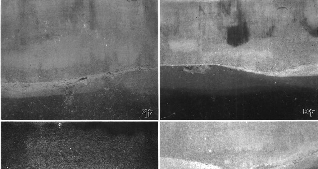

3
, 2 types of aspects in this series: (a) deep sand stratum; (b) dark-grey horizon with vo~ds In 3 cm depth.")
 Frame 32, (b) Frame 39 Fig. 6. Stn B (125 m). Sandy ripples on even dark to black sulph~de layer (a, b, d); thin oxygenated surface layer with medium boundary roughness (1.")
4 Fig. 5. Stn C (250 m). Sandy ripples; surface layer 3.1 cm (mean) (a); rose mud clasts (dr~lling mud); boundary roughness 1.3 cm; rose clay horizon also shows old bent ripple structure (b), 2 types of aspects in this series: (a) deep sand stratum; (b) dark-grey horizon with vo~ds In 3 cm depth. S~ngle Chaeloplerus and gastropod ~nd~v~cluals. V~deo records (2 \vk later) at 200 m d~stance from Stn A show signs of new sed~mentransport at 90' to old r~pples and generally a very un~form picture. (a) Frame 32, (b) Frame 39 Fig. 6. Stn B (125 m). Sandy ripples on even dark to black sulph~de layer (a, b, d); thin oxygenated surface layer with medium boundary roughness (1.2 dm); Frame 44 with 2 sulphide bands and an Ophiura on the surface (c); s~ngle rose mud clasts (drilling mud) in surface layer. General view: most affected station by reduced sediment on th~s transect with varying but clear sulphide zone just below the surface. (a) Frame 42; (b) Frame 43; (c) Frame 44; (d) Frame 46


5


6 308 BREMERHAVEN WORKSHOP. BENTHOS COMMIJNITY ANALYSIS &zgs z.,7jum 5 Q'? a was 9 Q);= L d rd -m.c $Eg: x c g%,.f- &= 2 a, "lm E $Xc 2 --, a,.yu $;S- >zz 4iaB ZZCD c 3 2 m J0 L O Q L O ozzq1e $2 2: E a-c & X a S C m 2c S z2.e PIZU VI,C =--Pi 35,=5 0 5 g 3 2 cszo ='m S2. a 0 $ E ' " m2;: -U,? 2 m C L 0 a 3 ;,S2 m L Z - U G
7 0 Rumohr & Schomann: REMOTS sed~ment profiles 309 Table 1 List of REMOTS Sediment Profile Images and derived measures (station, frame number, penetration depth of prism. thickness of apparent surface layer, boundary roughness) Station Frame Penetr. depth (cm) Depth of surface lavel- (cm) Boundary no. h4ln Max blean Min Max Mean roughness (cm) m O o (c) : I l.s 7.5 > O O 2000 m O (F) > 5.1 > > O m > (E) > ] m (D) , > > S ii O 1.O > L m l , > O o j > > ::(I m (B) a > failure 1.O O 1 0 m S (A) failure O ii > O 1.0
8 310 BREMERHAVEN WORKSHOP: BENTHOS COMMUNITY ANALYSIS 'A' 'B' n Water -Core sampler Sediment Fig. 8. Schematic REMOTS sediment profile image showing 'new' uncontaminated sediment layers on top ('A') and 'old' potentially contaminated layers below ('B') 500 m, Stn D; 250 m, Stn C; 125 m, Stn B; 0 m, Stn Aj with 5 to 11 replicates. Further details of the area may be gathered from Daan et al. (1992); station positions. and nomenclature are given by Stebbing & Dethlefsen (1992). The pictures were recorded on Eklachrome 100 ASA film. During a second cruise, with RV 'Holland' (26 to 29 March 19901, video recordings were made on 4 stations of the former transect (Stns A, C, E & G). A SIT (silicon intensified target) camera (Osprey OE 1352) was used mounted on a pan and tilt head in a frame hanging from the anchored ship. The frame was placed from time to time for 10 to 20 s on the sea floor to obtain clear close-up records. The REMOTS photographs were evaluated in terms of penetration depth of a prism as a measure of sediment compaction, thickness of apparent surface layer, surface boundary roughness (ripple marks), internal secondary layers, sulphide layers, mud clasts and biogenic structures, as well as epifauna. The video records gave valuable supplementary information on the sediment surface features and epifauna or their traces. RESULTS The numerical data from the sediment proflle records are summarised in Table 1. The general pattern of the profile lmages was a sandy surface layer of to 2.0 cm. Two weeks later, video records show that these old ripples had been coated with new ripp1es"in statu nascendi' or with earlier signs of incipient sand transport, oriented at approximately 90" to the old ripples. A surface layer of recently transported sand with a mean thickness of to 4.2 cm evenly covered the horizontal layers, the different colours of which showed signs of reduction. In some cases sulphide layers clearly showed organic/hydrocarbon enrichment by the drilling mud, which itself can be clearly traced by the rose colour of the benthonite in the oilbased drilling mud (L. de Jong pers. comm.). In general there was a clear division of 'old' and 'new' sediments at each station in the upper 5 cm, and this is discussed below. The single stations are described in the legends to Figs. 1 to 7, which show REMOTS images from Stns G to A, respectively. DISCUSSION The actual sampling pattern must be regarded as an emergency plan to gather at least some of the information planned to be retrieved from a grid sampling scheme around the abandoned drilling site. The adverse weather conaitions in early spring 1990 made proper sampling difficult. The results show that the seafloor was also heavily affected by storm and current action as can be seen from the ripple marks in 40 m depth and the video records of new sediment transport on top of old ripples. The presence of ripple marks makes the application of any diagenetic models questionable. From this and the general pattern of the REMOTS pictures (Fig. 8) it can be concluded that the oxygenated sandy surface layer in the investigation area was moved by current action after drilling activities had ended, and therefore is not primarily contaminated with drilling cuttings (low toxicity oil-based mud - OBM). This has serious implications for any further analysis of sediment samples (including meiofauna) since it is not clear which fraction of any sample is from the uncontaminated surface layer 'A' (up to 6.5 cm) and which from the potentially affected layer 'B' (Fig. 8). The stations look generally rather uniform although there is a clear concentration of sulphide layers at Stn B and less pronounced signs of sediment contamination at the central station (A) and as far away as 500 m from the drilling site. However, the stated distances of stations to the drilling site must be accepted with the provision that, even with correct navigation and positioning, the centre buoy and the anchored ship moved in the current and the resulting error may amount to up to 100 m or more. Nevertheless, it has been shown that imaging methods prove to be a powerful tool (even under difficult circumstances) to rapidly document general features of the sediment surface and the upper sediment layers which could not be retrieved by other means. There remains, however, a need for further investigations with REMOTS and video in combination with other traditional methods (Rumohr 1990) in a 'fresh' gradient at an active drilling
9 Rumohr & Schomann: REMOTS sediment profiles 311 site to demonstrate the acute effects of contamination where they are not masked by secondary sediment movements and alterations. A complete set of benthlc community data for the workshop is available from M. Carr, Plymouth Marine Laboratory, UK Acknowledgements. We gratefully acknowledge valuable comments and criticisms on this manuscript by Loes de Jong, Carlo Help and Paul Kingston. LITERATURE CITED Daan, R., van het Groenewoud, H., de Jong, S. A., Mulder, M. (1992). Physico-chemical and biological features of a drill- ing site in the North Sea, 1 year after dischdrges of oilcontaminated drill cuttings. Mar. Ecol. Prog. Ser Rumohr, H. (1990). Photographic evidence of changes in the sediment. AMBlO Spec. Rep Rurnohr, H. (1991a) led.). Imag~ng methods in benth~c ecology, report of the workshop. In: Keegan, B. (ed.) Activity Report COST 647. CEC, Brussels. p Rumohr, H. (1991b). Utility of imaging methods in benthic research. In: Keegan, B. (ed.) Activity Report COST 647, CEC, Brussels, p Rhoads, C., Gerrnano, D. (1987). Interpreting long-term changes in benthic community structure: a new protocol. Hydrobiologia 142: Stebb~ng, A. R. D.. Dethlefsen. V (1992). Introduction to the Bremerhaven Workshop on Biological Effects of Contaminants. Mar. Ecol. Prog. Ser. 91: 1-8
Wilson Bay Sediment Profile Imaging: 1. Instrument Test
 Environment Waikato Technical Report 2006/09 Wilson Bay Sediment Profile Imaging: 1. Instrument Test Prepared by: Kay C. Vopel, Greig Funnell (National Institute of Water & Atmospheric Research Ltd) For:
Akvaplan-niva rapport
 Grunnlagsundersøkelse på Snøhvit og Område C i Barentshavet, 2003 Akvaplan-niva rapport APN-411.2785-1 Introduction Statoil and Norsk Hydro commissioned Akvaplan-niva AS to perform baseline surveys at
Coring and sediment sampling
 Coring and sampling Principle: In order to ground-truth geophysical data, it is necessary to obtain a sample of the seabed. There are two main techniques available for sampling unconsolidated s : (1) seabed
Award # N LONG TERM GOALS
 Non-Invasive Characterization Of Small-Scale Patterns Of Benthic Biogenic Structure By Ultrasound: Infaunal Dynamics And Sediment Structure, And Effect Of Sediment Disturbance Donald G. Webb Graduate School
Changes in bottom morphology of Long Island Sound near Mount Misery Shoal as observed through Repeated Multibeam Surveys
 Changes in bottom morphology of Long Island Sound near Mount Misery Shoal as observed through Repeated Multibeam Surveys Laurie A. Zaleski Laurie.Zaleski@msrc.sunysb.edu Roger D. Flood rflood@notes.cc.sunysb.edu
2013 Sediment Profile Imaging Surveys
 2013 Sediment Profile Imaging Surveys Commencement Bay and Elliott Bay DMMP Sites Final October 21, 2013 NewFields 115 2 nd Ave N, Suite 100 Edmonds, WA 98020 Cover photo compliments of Charlie Eaton Photo
Confidence Assessment Scoring System
 Confidence Assessment Scoring System Confidence field Confidence group Confidence question Comments Remote sensing data collection RemoteTechnique Were the techniques used appropriate for the ground type?
Laboratory#6 Sediment Particle Size Distribution and Turbidity Flows
 Laboratory#6 Sediment Particle Size Distribution and Turbidity Flows Although this laboratory will pertain to oceanic sediments similar processes can also be observed on land and other aquatic systems
Fine-scale Survey of Right and Humpback Whale Prey Abundance and Distribution
 DISTRIBUTION STATEMENT A: Approved for public release; distribution is unlimited. Fine-scale Survey of Right and Humpback Whale Prey Abundance and Distribution Joseph D. Warren School of Marine and Atmospheric
Physiography Ocean Provinces p. 1 Dimensions p. 1 Physiographic Provinces p. 2 Continental Margin Province p. 2 Deep-Ocean Basin Province p.
 Physiography Ocean Provinces p. 1 Dimensions p. 1 Physiographic Provinces p. 2 Continental Margin Province p. 2 Deep-Ocean Basin Province p. 2 Mid-Ocean Ridge Province p. 3 Benthic and Pelagic Provinces
US ARMY CORPS OF ENGINEERS New England District BUILDING STRONG
 US ARMY CORPS OF ENGINEERS New England District STUDIES Sediment Sampling Biological Sampling (benthic community analysis) Hydroacoustic Surveys (side scan sonar, bathymetry) Remotely Operated Vehicle
APPENDIX F SEDIMENT PROFILE REPORT
 APPENDIX F SEDIMENT PROFILE REPORT F-1 F-2 Appendix F SEDIMENT PROFILE CAMERA RECONNAISSANCE OF BENTHIC HABITATS IN DELAWARE BAY, SEPTEMBER 2000. Robert J. Diaz R. J. Diaz and Daughters 6198 Driftwood
Donald K. Stauble and Bill Birkemeier Coastal and Hydraulics Laboratory US Army Corps of Engineers
 Donald K. Stauble and Bill Birkemeier Coastal and Hydraulics Laboratory US Army Corps of Engineers Define the Problem Navigation Shore Protection Environmental Political So what is the problem? Management
Leibniz Institute for Baltic Sea Research Warnemünde (Germany)
") Leibniz Institute for Baltic Sea Research Warnemünde (Germany) C r u i s e R e p o r t r/v "Poseidon" Cruise No. P 475 This report based on preliminary data and results Institut für Ostseeforschung Warnemünde
Leibniz Institute for Baltic Sea Research Warnemünde (Germany) C r u i s e R e p o r t r/v "Poseidon" Cruise No. P 475 This report based on preliminary data and results Institut für Ostseeforschung Warnemünde
Sediment Sampling Methods & Considerations. MSC-210 Marine Environmental Sampling & Analysis Lecture 7
 Sediment Sampling Methods & Considerations EQUIPMENT, DECONTAMINATION, PRESERVATION, STORAGE, & TRANSPORTATION MSC-210 Marine Environmental Sampling & Analysis Lecture 7 Purpose of Sediment Collection
Appendix A: Core descriptions
 Appendix A: Core descriptions Core: Tan0706 1 Water Depth: 2550m Gear: Piston Date Collected: 6/5/07 Date Described: 7/12/10 Description and Comments: 0-23 (2.5Y 6/4), light yellowish brown. Sandy silt.
Environmental impact assessment study of the new offshore dumping sites for Šventoji port in Lithuania
 Environmental impact assessment study of the new offshore dumping sites for Šventoji port in Lithuania Introduction Summary In 2003 Lithuanian Ministry of Transport initiated the preparation of feasibility
Feet CLAY; silty, greenish gray and clayey fine sand; Color: 5Y 3/1
 -. CLAY; silty, greenish gray and clayey fine sand; Color: Y /. -. SAND; fine-medium, clayey, with sandy clay layers; very abundant broken thin, tiny shells; shell hash at several horizons, heavily burrowed;
Marine Ecology Pacing Guide
 Marine Ecology Pacing Guide Course Description: The focus of the course is the interrelationships among marine organisms and the physical, chemical, geological and biological factors. North Carolina coastal
Changes in Geomorphology and Backscatter Patterns in Mount Misery Shoal, Long Island Sound as Revealed through Multiple Multibeam Surveys
 Changes in Geomorphology and Backscatter Patterns in Mount Misery Shoal, Long Island Sound as Revealed through Multiple Multibeam Surveys Laurie A. Zaleski Laurie.Zaleski@msrc.sunysb.edu, Roger D. Flood
Nova Scotia Department of Fisheries and Aquaculture. Environmental Monitoring Program Summary
 Nova Scotia Department of Fisheries and Aquaculture Environmental Monitoring Program Summary 2015 Table of Contents 1 Environmental Monitoring Program Overview... 1 2 2015 EMP... 5 2.1 Level I... 5 2.1.1
Meteor-Cruise M 75 / 2 Short Cruise Report Chief scientist: Dr. Jürgen Pätzold Universität Bremen Bremen / Germany
 Meteor-Cruise M 75 / 2 Short Cruise Report Chief scientist: Dr. Jürgen Pätzold Universität Bremen Bremen / Germany Dar es Salaam Dar es Salaam Febr. 06 th Febr. 24 th, 2008 1 SHORT CRUISE REPORT RV METEOR
How to Interpret Mining Company Drill Reports & Announcements
 How to Interpret Mining Company Drill Reports & Announcements A Simple Guide amscot Stockbroking Pty Ltd A division of State One Stockbroking Ltd (AFSL 247 100) Disclaimer: All information in this document
Lab 7: Sedimentary Structures
 Name: Lab 7: Sedimentary Structures Sedimentary rocks account for a negligibly small fraction of Earth s mass, yet they are commonly encountered because the processes that form them are ubiquitous in the
On the short-term and long-term impact of drilling activities in the Dutch sector of the North Sea
 ICES Journal of Marine Science, 53: 36 44. 1996 On the short-term and long-term impact of drilling activities in the Dutch sector of the North Sea Rogier Daan and Maarten Mulder Daan, R., and Mulder, M.
Directed Reading. Section: The Water Planet. surface is called the a. Earth s ocean. b. Pacific Ocean. c. salt-water ocean. d. global ocean.
 Skills Worksheet Directed Reading Section: The Water Planet 1. The body of salt water covering nearly three-quarters of the Earth s surface is called the a. Earth s ocean. b. Pacific Ocean. c. salt-water
Sediment and sedimentary rocks Sediment
 Sediment and sedimentary rocks Sediment From sediments to sedimentary rocks (transportation, deposition, preservation and lithification) Types of sedimentary rocks (clastic, chemical and organic) Sedimentary
Salmon Aquaculture Environmental Monitoring Data Report. Results of Sampling Program for Year Clayton Rd., RR #1 Sidney, BC V8L 5P6
 Salmon Aquaculture Environmental Monitoring Data Report Results of Sampling Program for Year 2002 by Cindy Wright 1, Bernie Taekema 2, Brenda Burd 1, and Eric McGreer 2 1 Ecostat Research Ltd. 1040 Clayton
Feet. Cape May Core #51 Start depth: 240 ft Stop depth: 245 ft Recovery (ft): 5.1 ft Date: 3/21/94 Described by: JVB, KGM, CL. 5.
: 5.1 ft Date: 3/21/94 Described by: JVB, KGM, CL. 5.") SAND; medium to fine sand with abundant silt, homogenous slightly mottled appearance; mica on outside, mostly quartz; few darks; peat layer.9 - ft; cnv - same as above; the last few cores are all the same;
SAND; medium to fine sand with abundant silt, homogenous slightly mottled appearance; mica on outside, mostly quartz; few darks; peat layer.9 - ft; cnv - same as above; the last few cores are all the same;
7.1 PROTOCOL FOR SEDIMENT MONITORING FOR NUTRIENTS, METALS AND PHYSICAL CHARACTERISTICS
 7.1 PROTOCOL FOR SEDIMENT MONITORING FOR NUTRIENTS, METALS AND PHYSICAL CHARACTERISTICS Overview Sediments can be collected using either a grab or core sampler. Core samplers are tube-like devices that
HIGH RESOLUTION SEDIMENT DYNAMICS IN SALT-WEDGE ESTUARIES
 HIGH RESOLUTION SEDIMENT DYNAMICS IN SALT-WEDGE ESTUARIES Philip Orton, Dept. of Environmental Science and Engineering, Oregon Graduate Institute Douglas Wilson, Dept. of Environmental Science and Engineering,
Feet. SAND; clayey, fine grained; shells are common; rounded quartz grains. SHELLS; muddy; almost no sand, shells and fragments common
 SAND; clayey, fine grained; shells are common; rounded quartz grains SHELLS; muddy; almost no sand, shells and fragments common SAND; back to medium to fine; has a mottled appearance and looks burrowed;
GEOS 302 Lab 3: Sedimentary Structures (Reference Boggs, Chap.4)
") GEOS 302 Lab 3: Sedimentary Structures (Reference Boggs, Chap.4) Objectives: 1. Become familiar with the different sedimentary structures 2. Understand the origin of these different structures and be able
GEOS 302 Lab 3: Sedimentary Structures (Reference Boggs, Chap.4) Objectives: 1. Become familiar with the different sedimentary structures 2. Understand the origin of these different structures and be able
FINMARINET: Inventories and Planning for the Marine Natura 2000 Network in Finland. A.2 Geological inventories of the seafloor Final Report
 LIFE07 NAT/FIN/000151 FINMARINET: Inventories and Planning for the Marine Natura 2000 Network in Finland A.2 Geological inventories of the seafloor Final Report Geological Survey of Finland, GTK 1. Introduction
Sediments: a source of chemicals for the marine environment, in more than one way. Jos van Gils 1, Remi Laane 1, Kees van de Ven 2
 Sediments: a source of chemicals for the marine environment, in more than one way Jos van Gils 1, Remi Laane 1, Kees van de Ven 2 1 DELTARES, The Netherlands 2 RIJKSWATERSTAAT Water Service, The Netherlands
Strategies for and results from the investigation of migrating bedforms in the German Bight
 Strategies for and results from the investigation of migrating bedforms in the German Bight Thomas F. WEVER 1, Ingo H. STENDER 2 1 Forschungsanstalt der Bundeswehr für Wasserschall und Geophysik (FWG),
Determination of emamectin benzoate in marine sediments in the vicinity of fish farms in Norway
 Determination of emamectin benzoate in marine sediments in the vicinity of fish farms in Norway (emamectin benzoate) SLI (emamectin benzoate, EMB) is a medicated feed premix indicated for the treatment
Seed Mussel Survey Report update for the Wicklow Area 25 to 30/07/2013
 Seed Mussel Survey Report update for the Wicklow Area 25 to 30/07/2013 Vessel: MV T Burke (BIM, Skipper John Murphy, Survey Officer Nicolas Chopin Equipment: 400 khz side scan sonar, 1 meter dredge. Area
Validation of sea ice concentration in the myocean Arctic Monitoring and Forecasting Centre 1
 Note No. 12/2010 oceanography, remote sensing Oslo, August 9, 2010 Validation of sea ice concentration in the myocean Arctic Monitoring and Forecasting Centre 1 Arne Melsom 1 This document contains hyperlinks
Hydro One (Sept 2014) Hydro One (Sept 2014) Hydro One (Sept 2014)
 Hydro One (Sept 2014) Hydro One (Sept 2014)") TABLE 1 WELL CONSTRUCTION DETAILS MOE WWR No Well ID Location Installation Date Status Easting Coordinates Northing Source Elevation Screened Interval Screened Material Borehole Well Stick-up Ground Top
TABLE 1 WELL CONSTRUCTION DETAILS MOE WWR No Well ID Location Installation Date Status Easting Coordinates Northing Source Elevation Screened Interval Screened Material Borehole Well Stick-up Ground Top
ALKOR 346: First IFM-GEOMAR - HYPOX expedition to the Gotland Basin underway.
 ALKOR 346: First IFM-GEOMAR - HYPOX expedition to the Gotland Basin underway. From 18. Sept to 6 Oct. R/V ALKOR is working in the eastern Gotland Basin (central Baltic Sea.). The cruise led by R. Olaf
MONITORING SYSTEM GEOPHYSICAL ASPECTS OF CAPPING OPERATIONS
 STATUS REPORT DISPOSAL OPERATIONS AT THE CENTRAL LONG ISLAND SOUND DISPOSAL SITE DISPOSAL AREA MONITORING SYSTEM (DAMOS) FIELD VERIFICATION PROGRAM () GEOPHYSICAL ASPECTS OF CAPPING OPERATIONS CONTRIBUTION
Marine Sediments. Introductory Oceanography. Ray Rector: Instructor
 Marine Sediments Introductory Oceanography Ray Rector: Instructor Ocean Basins are Vast Sinks for Huge Amounts of Sediment from Numerous Different Sources Four Major Types of Seafloor Sediments 1. Lithogenous
Geotechnical Geotechnical Assessment
 Site Investigation Site Investigation Pile Probing Pile Probing Geotechnical Logging Geotechnical and Sampling Logging and Sampling Streetworks and Utilities Streetworks Avoidance and Utilities Avoidance
Dynamic preservation of the coastline
 Dynamic preservation of the coastline Content Introduction The Dutch coastal defence by dynamic processes Data collection Management of the sand resources Growing importance of marine sand and gravel resources
Computer Simulation of Sand Ripple Growth and Migration.
 Computer Simulation of Sand Ripple Growth and Migration. Douglas J. Wilson OGI School of Environmental Science and Engineering at the Oregon Health and Sciences University 20000 N.W. Walker Road, Beaverton,
Carte des peuplements benthiques des substrats meubles de la baie de Saint-Brieuc (Source Thouzeau G., Hamon D., 1992) - Echelle 1/ Score sheet
 - Echelle 1/ Score sheet") 16/07/2010 Carte des peuplements benthiques des substrats meubles de la baie de Saint-Brieuc (Source Thouzeau G., Hamon D., 1992) - Echelle 1/100000 sheet sensing? How good is the ground-truthing? How
16/07/2010 Carte des peuplements benthiques des substrats meubles de la baie de Saint-Brieuc (Source Thouzeau G., Hamon D., 1992) - Echelle 1/100000 sheet sensing? How good is the ground-truthing? How
Biological long-term experiments in 2500 m water depth at the LTER observatory HAUSGARTEN
 Biological long-term experiments in 2500 m water depth at the LTER observatory HAUSGARTEN T. Soltwedel, C. Hasemann, M. Jacob, I. Schewe Alfred-Wegener-Institut Helmholtz-Zentrum für Polar- und Meeresforschung
Bowen s Chemical Stability Series
 Lab 5 - Identification of Sedimentary Rocks Page - Introduction Sedimentary rocks are the second great rock group. Although they make up only a small percentage of the rocks in the earth s crust (~5%)
CRUISE SUMMARY REPORT
 CRUISE SUMMARY REPORT Centre: DOD Ref. No.: FOR COLLATIMG CENTRE USE Is data exchange restricted Yes In part No Page 1 SHIP enter the full name and international radio call sign of the ship from which
SCOPE 35 Scales and Global Change (1988)
") 1. Types and origins of marine sediments 2. Distribution of sediments: controls and patterns 3. Sedimentary diagenesis: (a) Sedimentary and organic matter burial (b) Aerobic and anaerobic decomposition
1. Types and origins of marine sediments 2. Distribution of sediments: controls and patterns 3. Sedimentary diagenesis: (a) Sedimentary and organic matter burial (b) Aerobic and anaerobic decomposition
'0"W. Sigguk 70 45'0"N. B a f f i n. B a y. Bathymetric high referenced in section A l h a. g e. o u g h. i d.
 p 60 50'0"W Baffin Bay Greenland Sigguk B a f f i n B a y S h e l f E d g e Beta 8 6 5 4 19 21 U u m m a n n a q C h a n n e l Note: Lineaments are iceberg scours Gamma 3 10 12 1 11 2 Bathymetric high
Red Sea - Dead Sea Water Conveyance Study Program Additional Studies
 Red Sea - Dead Sea Water Conveyance Study Program Additional Studies Red Sea Study Final Report Annex 1 Field and laboratory activities carried out during the study and their results July 213 TABLE OF
Introduction to Acoustic Remote Sensing and Seafloor Mapping (AE4-E13) May 19, 2010
 May 19, 2010") Introduction to Acoustic Remote Sensing and Seafloor Mapping (AE4-E13) May 19, 2010 1 Delft Vermelding Institute onderdeel of Earth organisatie Observation and Space Systems Why Acoustic Remote Sensing?
Introduction to Acoustic Remote Sensing and Seafloor Mapping (AE4-E13) May 19, 2010 1 Delft Vermelding Institute onderdeel of Earth organisatie Observation and Space Systems Why Acoustic Remote Sensing?
Scientific Report of AMBER subproject WP B.4. Identification and quantification of submarine groundwater. discharge
 Scientific Report of AMBER subproject WP B.4 Identification and quantification of submarine groundwater discharge Compiled by M. E. Böttcher, O. Dellwig, R. Endler, S. Vogler, M. Schafmeister, L. Kotwicki,
A big data approach to macrofaunal baseline assessment, monitoring and sustainable exploitation of the seabed
 Oil & Gas UK Environmental Seminar Aberdeen, 12 Dec 2017 A big data approach to macrofaunal baseline assessment, monitoring and sustainable exploitation of the seabed Keith Cooper & Jon Barry Centre for
Short Cruise Report RV MARIA S.MERIAN Cruise MSM18/5 Walvis Bay Walvis Bay Chief Scientist: Lutz Postel Captain: Friedhelm v.
 Dr. Lutz Postel Institute for Baltic Sea Research (IOW) Seestr. 1 D-18119 Rostock-Warnemünde Tel.: +49 381 5121 206 Fax: +49 381 5197 440 email: lutz.postel@io-warnemuende.de Short Cruise Report RV MARIA
ENCE 3610 Soil Mechanics. Site Exploration and Characterisation Field Exploration Methods
 ENCE 3610 Soil Mechanics Site Exploration and Characterisation Field Exploration Methods Geotechnical Involvement in Project Phases Planning Design Alternatives Preparation of Detailed Plans Final Design
Evolution and Life in the Ocean
 Characteristics of All Living Things Contain matter in a highly organized state Capture, store and transmit energy; all organisms require energy Capable of reproduction Change through time and adapt to
Acoustical recognition of the bottom sediments in the southern Baltic Sea
 Acoustical recognition of the bottom sediments in the southern Baltic Sea PACS: 43.30.Ma Jaros³aw Têgowski Institute of Oceanology, Polish Academy of Sciences, Powstañców Warszawy 55,8-7 Sopot, Poland,
BAUER MeBo Sea Bed Drill Rig
 BAUER MeBo Sea Bed Drill Rig Spotlights BAUER Maritime Experiences 1993 Diamond deposit exploration with a BC cutter in water depth of 160 m (South Africa) Atlantic Ocean 2005 Drilling inside of a monopile
UNIT 4 SEDIMENTARY ROCKS
 UNIT 4 SEDIMENTARY ROCKS WHAT ARE SEDIMENTS Sediments are loose Earth materials (unconsolidated materials) such as sand which are transported by the action of water, wind, glacial ice and gravity. These
ARE YOU READY TO THINK? Look at the first slide THINK PAIR SHARE!
 ARE YOU READY TO THINK? Look at the first slide THINK PAIR SHARE! WHAT PROMINENT FEATURE CAN YOU IDENTIFY IN THIS PICTURE? What do you think the different colors represent? Who might find such a picture
Acoustic classification of fine-scale sediment variability and interconnection with benthic habitats of the Eckernförde Bay, Kiel
 7 th Workshop Seabed Acoustics, Rostock, November 19/20, 2015 P11-1 Acoustic classification of fine-scale sediment variability and interconnection with benthic habitats of the Eckernförde Bay, Kiel Evangelos
In situ characterisation of habitats adjoining cold water coral reefs using a Sediment Profile Imagery (SPI) camera
 camera") In situ characterisation of habitats adjoining cold water coral reefs using a Sediment Profile Imagery (SPI) camera Silvana N.R. Birchenough, Nigel Lyman, David A. Roberts, Juan Moreno Navas and J. Murray
In situ characterisation of habitats adjoining cold water coral reefs using a Sediment Profile Imagery (SPI) camera Silvana N.R. Birchenough, Nigel Lyman, David A. Roberts, Juan Moreno Navas and J. Murray
Shoreline Assessment Job Aid National Oceanic and Atmospheric Administration NOAA Ocean Service Office of Response and Restoration Hazardous
 Shoreline Assessment Job Aid National Oceanic and Atmospheric Administration NOAA Ocean Service Office of Response and Restoration Hazardous Materials Response Division This job aid was produced and published
Interactive comment on Relations of physical and biogenic reworking of sandy sediments in the southeastern North Sea by Knut Krämer et al.
 Ocean Sci. Discuss., https://doi.org/10.5194/os-2018-152-rc1, 2019 Author(s) 2019. This work is distributed under the Creative Commons Attribution 4.0 License. Interactive comment on Relations of physical
Short summary of Project 1 activity during research cruise with RV Poseidon (P408-2a)
") Short summary of Project 1 activity during research cruise with RV Poseidon (P408-2a) Chief scientist: Dr. Mark Schmidt Shipboard scientific party: Dr. Peter Linke, Dr. Daniel McGinnis, Dr. Alaa Al-Barakati,
Short summary of Project 1 activity during research cruise with RV Poseidon (P408-2a) Chief scientist: Dr. Mark Schmidt Shipboard scientific party: Dr. Peter Linke, Dr. Daniel McGinnis, Dr. Alaa Al-Barakati,
Non-Technical Summary
 Non-Technical Summary Proposed Project TGS-NOPEC Geophysical Company ASA (TGS) proposes to undertake a two dimensional (2D) seismic survey and seabed sampling in the western Greenland Sea off North East
Marine Heat Flow Measurements Information Brochure
 Marine Heat Flow Measurements Information Brochure 5 1 2 3 4 5 5 6 7 8 5 9 10 11 12 13 14 5 15 16 17 18 19 20 21 5 22 0 200 400 600 800 1000 1200 1400 1600 Time (s) What is the use of heat flow measurements?
Some Characteristics of Grounded Floebergs near Prudhoe Bay, Alaska
 SHORT PAPERS 169 Some Characteristics of Grounded Floebergs near Prudhoe Bay, Alaska INTRODUCTION During the winter of 1974-75, a large number of floebergs (fragments of multi-year pressure ridges) were
Role of macrofauna and the impacts of natural and anthropogenic disturbance on sediment biogeochemical processes (Module 3)
") Biogeochemistry, macronutrient and carbon cycling in the benthic layer (BMCC) WP2 Role of macrofauna and the impacts of natural and anthropogenic disturbance on sediment biogeochemical processes (Module
Biogeochemistry, macronutrient and carbon cycling in the benthic layer (BMCC) WP2 Role of macrofauna and the impacts of natural and anthropogenic disturbance on sediment biogeochemical processes (Module
Relatively little hard substrate occurs naturally in the
 CHAPTER FIVE Rock Habitats Relatively little hard substrate occurs naturally in the estuary, owing mainly to the vast quantities of fine sediment that have been deposited by the rivers. Rock habitat is
Final Report Sediment Profile Imaging Survey Of Sediment And Benthic Habitat Characteristics Of The Lower Passaic River
 August, 2005 Final Report Sediment Profile Imaging Survey Of Sediment And Benthic Habitat Characteristics Of The Lower Passaic River Lower Passaic River Restoration Project Prepared for: Aqua Survey, Inc
GeoCanada 2010 Working with the Earth
 Lithofacies Identification and the Implications for SAGD Well Planning in the McMurray Formation, Christina Lake Area, Alberta Travis Shackleton*, Robert Gardner, Sung Youn, Grace Eng and Lori Barth Cenovus
ABP Southampton. Environmental Statement for Port of Southampton: Berth 201/202 Works. Appendix B. Dredge Material Characterisation
 ABP Southampton Environmental Statement for Port of Southampton: Berth 201/202 Works Appendix B Dredge Material Characterisation Appendix B Dredge Material Characterisation Environmental Statement for
Coastal Systems and Landscapes 3 days
 AS Level Geography WJEC Coastal Systems and Landscapes 3 days This course is for Welsh schools. This in-depth course prepares students for the physical fieldwork focusing on the Coastal option, for Section
Benthic habitat mapping: a synopsis of methodologies and approaches. Dr. Craig Brown University of Ulster
 Benthic habitat mapping: a synopsis of methodologies and approaches Dr. Craig Brown University of Ulster Technological advances in remote sensing Insitu sampling Improving technology Single beam acoustics/video
This file is part of the following reference: Access to this file is available from:
 This file is part of the following reference: Page, Geoff () Mass Transport Evaluation using consolidated VHF Radar and Acoustic Doppler Current Profiler data. Masters (Research) thesis, James Cook University.
Meteor Cruise M54/ / Short Cruise Report
 Meteor Cruise M54/1 6.7. 11.7 / 14.7. 10.8. Short Cruise Report The R/V Meteor Cruise M54/1 is the first in a row of 3 expeditions, which lead the vessel for the first time to the Pacific Ocean for research
Instream Sediment Control Systems
 Instream Sediment Control Systems INSTREAM PRACTICES Photo 1 Photo 2 Modular sediment The information contained within this series of fact sheets deals only with the design of temporary instream sediment
Sediment and Sedimentary rock
 Sediment and Sedimentary rock Sediment: An accumulation of loose mineral grains, such as boulders, pebbles, sand, silt or mud, which are not cemented together. Mechanical and chemical weathering produces
Baltic Sea Research Institute
 Baltic Sea Research Institute Warnemuende (IOW) Cruise Report No. 44/96/ 04 R/V "A.v.Humboldt" MESODYN Cruise 01 to 12 March 1996 Stolpe Furrow / Baltic Sea This report is based on preliminary data and
Appendix D Sediment Profile and Plan View Imaging Report
 Appendix D Sediment Profile and Plan View Imaging Report April 2010 Sediment Profile & Plan View Imaging Report Evaluation of Sediment and Benthos Characteristics Along Potential Cable Routes and Turbine
NOAA S Arctic Program in 2017
 NOAA S Arctic Program in 2017 NOAA s Arctic Mission To determine how the Arctic system is changing on time scales of weeks to decades, particularly with respect to the consequences that the loss of sea
Wetland Sediment Dynamics at Crissy Field Marsh Annual Report
 Wetland Sediment Dynamics at Crissy Field Marsh 27 Annual Report John Callaway Department of Environmental Science University of San Francisco 217 Fulton St. San Francisco, CA 94117 (415) 422-572 callaway@usfca.edu
J.B. Shaw and D. Mohrig
 GSA DATA REPOSITORY 2014008 J.B. Shaw and D. Mohrig Supplementary Material Methods Bathymetric surveys were conducted on 26 June- 4 July, 2010 (Fig. 2A), 7 March, 2011 (Fig. 2B), 11-12 August, 2011 (Figs.
Summary. Introduction. Observations and Interpretations
 Lower McMurray Formation sinkholes and their fill fabrics: effects of salt dissolution collapse-subsidence across the northern Athabasca oil sands deposit Paul L. Broughton, Chevron Canada Resources, Calgary,
Picture: Nigel Keeley. SustainAqua. Sustainable aquaculture in the North identifying thresholds, indicators and tools for future growth
 Picture: Nigel Keeley SustainAqua Sustainable aquaculture in the North identifying thresholds, indicators and tools for future growth 4 årigt forskningsråds prosjekt Norway International Raymond Bannister
VIDEO/LASER HELICOPTER SENSOR TO COLLECT PACK ICE PROPERTIES FOR VALIDATION OF RADARSAT SAR BACKSCATTER VALUES
 VIDEO/LASER HELICOPTER SENSOR TO COLLECT PACK ICE PROPERTIES FOR VALIDATION OF RADARSAT SAR BACKSCATTER VALUES S.J. Prinsenberg 1, I.K. Peterson 1 and L. Lalumiere 2 1 Bedford Institute of Oceanography,
Prof. Stephen A. Nelson EENS 111. Groundwater
 Page 1 of 8 Prof. Stephen A. Nelson EENS 111 Tulane University Physical Geology This page last updated on 20-Oct-2003 is water that exists in the pore spaces and fractures in rock and sediment beneath
4 Project Alternatives
 BSD Deepening EIR Page 50 4 Project Alternatives In terms of the EIA regulations (Regulation 6 (1) (d) GN No. R1183, dated 5 September 1997) and NEMA, the applicant is required to demonstrate that alternatives
2000 harbor benthic monitoring report
 2 harbor benthic monitoring report Massachusetts Water Resources Authority Environmental Quality Department Report ENQUAD 22-2 Citation: Kropp RK, Diaz RJ, Dahlen DT, Boyle JD, Hunt, CD. 22. 2 Harbor Benthic
Field test of a novel, low-cost, scanner-based sediment profile imaging camera
 LIMNOLOGY and OCEANOGRAPHY: METHODS Limnol. Oceanogr.: Methods 4, 2006, 30 37 2006, by the American Society of Limnology and Oceanography, Inc. Field test of a novel, low-cost, scanner-based sediment profile
FRontiers in Arctic marine Monitoring: The FRAM Ocean Observing System
 FRontiers in Arctic marine Monitoring: The FRAM Ocean Observing System Thomas Soltwedel Alfred-Wegener-Institute Helmholtz-Center for Polar and Marine Research Arctic Frontiers 2017 Svalbard Symposium
Incipient sediment motion across the river to debris-flow transition
 Movie DR1 Movie DR2 Movie DR3 Movie DR4 GSA DATA REPOSITORY 2014067 SUPPLEMENTARY MATERIALS FOR Incipient sediment motion across the river to debris-flow transition Jeff P. Prancevic, Michael P. Lamb,
Objectives: Define Relative Age, Absolute Age
 S6E5. Students will investigate the scientific view of how the earth s surface is formed. c. Classify rocks by their process of formation. g. Describe how fossils show evidence of the changing surface
Past German environmental impact studies on Manganese nodules. Dr. Gerd SCHRIEVER. Hohenwestedt Germany
 Past German environmental impact studies on Manganese nodules Dr. Gerd SCHRIEVER Hohenwestedt Germany International Environmental Studies for future Deep-Sea Mineral Mining 1977 1981 MESEDA Red Sea (Saudi
Thwaites and Pine Island Glaciers of Antarctica and the Prospect of Rapid Sea Level Rise
 Thwaites and Pine Island Glaciers of Antarctica and the Prospect of Rapid Sea Level Rise Thomas Mortlock and Paul Somerville, Risk Frontiers The Thwaites and Pine Island glaciers in Antarctica are flowing
13. Sedimentary Rocks I (p )
") 13. Sedimentary Rocks I (p. 194-208) Sediment Deposition Weathering results in rock being broken down into smaller fragments, called regolith. This regolith is then broken down to form soil. The regolith
13. Sedimentary Rocks I (p. 194-208) Sediment Deposition Weathering results in rock being broken down into smaller fragments, called regolith. This regolith is then broken down to form soil. The regolith