Land Suitability Classification of a Desert Area in Egypt for Some Crops Using Microleis Program
|
|
|
- Curtis Chase
- 5 years ago
- Views:
Transcription
1 American-Eurasian J. Agric. & Environ. Sci., 8 (1): 80-94, 010 ISSN IDOSI Publications, 010 Land Suitability Classification of a Desert Area in Egypt for Some Crops Using Microleis Program A.A, Aldabaa, Hailin Zhang, Asmaa Shata, Said El-Sawey, 3 Ali Abdel-Hameed, Jackie L. Schroder 1 Desert Research Center, Egypt Department of Plant and Soil Sciences, Oklahoma State University, USA 3 Faculty of Agriculture, Cairo University, Egypt Abstract: Desert reclamation for agricultural production is one of the priorities to compensate for the loss of agricultural land and to minimize food supply shortage in Egypt. Wadi El-Rayan Depression is one of the reclamation projects the Egyptian government has initiated. Since cultivation started at Wadi El-Rayan Depression, several problems have arisen in the project area including soil salinity, drought, water logging and expansion of the water bodies. This region is a world heritage site and has been selected to be a protected area. Thus, optimum use of the resources in the region needs to be thoroughly evaluated. Based on the interpretation of satellite image with the dominant geomorphic units, 65 soil profiles represented by 138 soil samples were characterized in Wadi El-Rayan Depression. A Web-based program, MicroLEIS, was used to compare the soil characteristics and quality needed for 1 different types of crops. The Web-based soil evaluation system indicated that the soils of the study area are not suitable for the selected crops due to one or more limiting factors. However, there are some exceptional cases where the soils were either suitable or marginally suitable. Unnecessary agricultural expansion may harm or damage the study area. Alternatively, continuing to improve tourism activities is a better land use for natural resource protection and economical development in Wadi El-Rayan Depression. Key words: Suitability MicroLEIS Almagra Model Wadi El-Rayan Depression Egypt INTRODUCTION focused on Wadi El-Rayan as one of the newly reclaimed areas in the desert to increase agricultural production. The The Wadi El-Rayan Depression was designated as a Egyptian Governorate had planned to reuse the lake Protected Area in 1989 by the Egyptian Government to waters to reclaim some areas in Wadi El-Rayan protect the area s biological, geological and cultural Depression. In 1984, the infrastructure including the resources. The depression covers approximately 1,759 km construction of roads, irrigation canals and uplifting and is located in the southwest of El-Fayum Governorate pumps to reclaim 4800 ha was initiated. Since then, about about 135 km from Cairo. A diversity of habitats, each 769 ha have been reclaimed west of the lower lake. In 1999, with its own characteristic wildlife and other biological people started to settle there and began farming on about features, comprises the Protected Area. Moreover, this 1 ha per family. area is distinguished by many beaches and waterfalls. The Several problems have appeared in the area due to depression is also home of Egypt s first natural World reclamation efforts including high salinity, drought and Heritage Site, Valley of the Whales and is an water logging. Water logging has contributed to internationally designated Important Birds Area [1]. extending the water bodies through the study area in Historically, Wadi El-Rayan Depression was selected addition to its negative effects on plant growth and as a solution to cope with the excess drainage waters in production. Therefore, it is necessary to evaluate the soils the El-Fayum Depression through an 8 km underground of the project area and the surrounding areas in order to drainage system in The drainage waters understand which factors negatively affect cultivation accumulated year by year leading to the formation of two and to find alternative promising areas suitable for large artificial lakes. Recently, the Egyptian Governorate agriculture or other uses. Corresponding Autor: A.A, Aldabaa, Desert Research Center, Egypt 80
2 Land characteristics Land qualities Useful Depth Ease of root penetration Texture Drainage Water Availability Carbonate Salinity Oxygen Availability Na Saturation Nutrient availability Profile Development Crop Production Fig. 1: General scheme of the Almagra model, showing the direct and indirect effects of some soil characteristics and soil qualities The fundamental principle of land evaluation is to types of annual, semiannual and perennial crops. In estimate the potential of a land for different productive addition, the classification is applicable to all arid and uses, such as farming, livestock production, or forestry, semi-arid condition throughout the Mediterranean together with uses that provide services or other benefits, Region. The soil suitability Almagra model is based on such as water catchment, recreation, tourism and wildlife analysis of edaphic factors which affect the productivity conservation []. Consequently, land evaluation is a tool of twelve traditional crops: wheat, maize, melon, potato, for strategic land use planning. A specific agricultural use soybeans, cotton, sunflower, sugar-beet, alfalfa, peach, and management system on land that is most suitable citrus and olive. The edaphic factors including the according to agro-ecological potentialities and limitations effective depth (p), texture (t), drainage (d), carbonate is the best way to achieve sustainability [3]. content (c), salinity (s), sodium saturation (a) and degree There are different models for conducting land of profile development (g) are used as diagnostic criteria evaluation in land use planning [4]. However, the (Figure 1). Microcomputer Land Evaluation Information System MicroLEIS program has not been used to evaluate (MicroLEIS) package has been considered a user-friendly the soils of the study area [6] evaluated the soils located agro-ecological decision support system for sustainable on the eastern side of Wadi El-Rayan depending on their land use and management [5]. The MicroLEIS with an own understanding of land evaluation. The revealed data Almagra model (Agricultural Soil Suitability) has been showed that most of the soils were rated as less than 5%, used to assess the suitability of different soils [5]. The meaning the soils are non-agricultural. The land capability program works interactively, comparing the values of the classification [7] used to evaluate some soils of Wadi characteristics of the land unit with the generalization El-Rayan Depression demonstrated that most of the soils levels designated for each suitability class for specific were not suitable for agricultural uses [8]. 81
3 As for the other desert soils in Egypt, MicroLEIS has classes. Wahba et al. [1] studied the soils of been used to determine the main limiting factors that Sahal Baraka, Farfra Oasis to assess the suitability of hinder or reduce soil productivity. In Banger El-Soker soils for olives, peach and sunflower. The results revealed area, Egypt, this program was used to assess the soil the following order of suitability: olive > peach> suitability for some specific crops [9]. This study found sunflower, melon and corn. This sequence reflects the that the common suitability subclasses were suitable (S) priority of agricultural land utilization. Salem [13] found and moderately suitable (S3) whereas one or more of the that the soils of El- Bostan area were highly suitable, soil properties such as texture, profile depth, salinity, moderate suitable and not suitable with respect to soil alkalinity and soil fertility were the main limiting factors. texture and exchangeable sodium percent (ESP) in most The MicroLEIS program was used to predict the effect of soil profiles. water table and salinity on the productivity of wheat in The objectives of this study are to (1) determine the the same area [10]. Their results indicated the productivity common land characteristics of the Wadi El-Rayan of wheat decreased with increasing salinity and Depression, () assess the main land use limitations in the decreasing water table depth due to the poor management depression and (3) evaluate the land suitability of the practices in the area. depression for some crops using the MicroLEIS Land Darwish et al. [11] evaluated the soils of Farafra Evaluation System. Oasis as one of the newly reclaimed areas in Egypt using MicroLEIS. Their output data showed that most of the MATERIALS AND METHODS Typic Haplogypsids soil unit was highly suitable for wheat, potato and sunflower, while the rest of the units The study area, Wadi El-Rayan Depression and its had low suitability with a dominant soil texture limitation. environs, is situated between longitudes and The soils of Calcic Haplosalids and Gypsic Haplosalids E and latitudes and N showed moderate suitability with texture and/or drainage (Figure ). The area is located west of El-Fayum limitations. The other units were not suitable due to the Depression in the western desert and is approximately 135 limiting factors of salinity, sodium saturation and texture km west of Cairo. Mediterranean Sea Delta Wadi El-Rayan Depression Cairo Sinai peninsula Western Desert River Nile Eastern Desert Red Sea Fig. : Location map of the studied area 8
4 a b c Fig. 3: MicroLEIS program (Almagra model); a) the main interface of MicroLEIS throughout you can pick up the model you need, b) the interface to input your own data, and c) the output data for the selected crops According to the geological map [14] the study area The gravels content was measured by volume is essentially of Middle Eocene limestone and lacustrine according to USDA [17]. The total calcium carbonate was deposits of Pleistocene. The lacustrine deposits occupy measured by treating the samples with HCl and the the eastern portion of the study area. The middle Eocene evolved CO was measured manometrically, [17]. beds, clay, marl and limestone with Numilities are forming The exchangeable sodium percent is the relative amount the oldest beds found in the area. The climate of the study of exchangeable sodium and cation exchangeable area is typically arid, where the mean annual temperature, capacity. According to Bashour and Sayegh [18], the rainfall, evapotranspiration and relative humidity are exchangeable sodium was estimated using Ammonium.0 C,.0 mm, 10 mm and 51%, respectively. acetate method. While the cation exchangeable capacity The dominant landforms were delineated based on was measure by sodium oxalate method for gypsiferous Digital elevation model (DEM) and satellite image and calcareous soils. The electrical conductivity (EC) was (Enhanced Thematic Mapped ETM+) obtained from estimated in the extracted soil paste by Conductimeter, United State Geological Survey site [18]. The organic matter was measured using usgs.gov/earthexplorer (USGS) [15] and geological Walkley-Black Wet method, [18]. formations covering the study area. Accordingly, the The soil texture class was determined using dry study area was masked using ArcGIS 9.3 to extract the sieving method for sandy textured soils (fine fraction less actual study area by excluding the unrepresentative areas. than 5%) according to Piper [19] and by hydrometer During the field study, the landforms were checked to method for heavier textured soil (fine fraction more than define the boundary of each landform. Accordingly the 5%) according to Gavlak et al. [0]. The mean weighted study area (masked map) was used as a base map and was value of each determined soil property (V) that was used represented by 65 soil profiles. The soil profiles were to evaluate the soils was calculated based on multiplying morphologically described according to FAO [16]; the parameter value (Vi) of each horizon by horizon consequently, 138 soil samples were collected and thickness (ti) divided by the total profile depth (T) processed for laboratory analyses. according to the following equation [1]: 83
5 n and wet sabkhas (i.e. salt flat) with dense halophyte plant (vi ti) i = 1 v = species. The sabkhas formation was formed mainly from T the water intrusion or seepage from El-Rayan lakes. The surface is almost flat to gently undulating. The west 1 km of this area is occupied by olive trees and different After the final data preparation, the physical and kinds of field crops. However, most of these plants are chemical properties were applied to Almagra Model unhealthy due to high salinity. available at microleis/ microlei/ microlei.aspx) [] to run the land suitability Aeolian Deposits Complex: This unit encompasses evaluation for some selected crops: wheat (W), maize (M), approximately 163 km and is located mainly at the extreme melon (Me) potato (P), soybean (S), cotton (A), sunflower southern part of the study area (Figure 7) with dissected (G) and sugar beat (R) as annuals; alfalfa (Af) as forms existing on the soils of El-Rayan karstified plateau. semiannual and peach (Pe), Citrus fruit (C) as well as olive Three types of land elements represent this landform: (O) as perennials, (Figure 3). The spatial analysis function sand ripples, sand heaps and sabkhas (sandy hillocks) in ArcGIS 9.3 was used to create thematic layers of the and longitudinal sand dunes [3]. The longitudinal sand most constrained factors. dunes are the most common type and extend parallel to the eastern side of monqar El-Rayan mesa. Generally, the RESULTS AND DISCUSSION longitudinal sand dunes are organized in NNW to SSE direction which corresponds to the prevailing wind Landforms of the Study Area: The Digital Elevation direction. Model, (Figure 4) was presented in 3D mode and was then overlaid by Landsat ETM+ image, (Figure 5) to produce a Alluvial Plain: Two alluvial plains occur in the study area 3D image for the study area,(figure-6). The produced 3D (Figure 7). The larger one covers the northwest portion image was consequently used along with the ground truth while the smaller one is located at the southwest portion data to delineate the different landforms of the area under of the study area and occupies an area about 194 km. investigation. Therefore, it was masked to get the final This unit is relatively flat and was created by the representative area by excluding the highland and Qarun deposition of the sediments eroded and transported from Lake (Figure-7). The resulting image shows that the study the adjacent highlands: Qattrani- birket Qarun plateau, area is represented by 8 landforms; each landform is Qaret Gehanem plateau and Qaret El-Robban plateau. represented by several soil profiles, namely: isolated hills, The sediment eroded, transported, deposited and El-Rayan lakes, Quta-Qarun depression, El-Rayan reshaped by water is typically made up of a variety of depression, alluvial plain, Aeolian deposits complex rocky materials including fine particles of silt and clay and larger and desert pavement plain and El-Rayan karstified particles of sand and gravel. Approximately 1 km of this plateau. The first and second landforms were not unit is cultivated with the same plants mentioned in the Elrepresented by any soil profiles due to the steep slope Rayan depression. and rockiness for the first one and the second one is a water-body. So there are not going to be discussed Rocky and Desert Pavement Plain: The total area of this hereafter. The landforms covering the study area are unit is approximately 177 km (Figure 7) and the surface summarized as following: cover is dominated by rock outcrops, desert pavement, or a combination of rock outcrops and desert pavement. Quta-qarun Depression: This area occupies The underneath rock is hard limestone that was identified approximately 90 km (Figure 7) and is almost covered by during the field study. The desert pavement forms a cultivation which is mainly olive trees, scattered palm surface gravel deposit of tightly packed pebbles, layered trees and some field crops such as maize, Egyptian clover just one pebble thick and generally devoid of vegetation. and alfalfa. This landform is almost flat, below sea level Generally, it is formed by gradual removal of the sand, and covered by fluvial and lacustrine sediments. dust and other fine grained materials by wind action that represent the main physical weathering in the study area. El-Rayan Depression: The depression covers an area that is approximately 137 km (Figure 7) representing the area El-rayan Karstified Plateau: The plateau is the largest located around the upper and the lower El-Rayan lakes. landform and covers approximately 446 km (Figure 7). The This unit is too below sea level and almost covered by dry soft carbonatic rocks form the main lithology of this unit. 84
6 Elevation (m) Fig. 4: Digital elevation model (DEM) 85


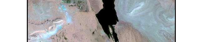

7 Fig. 5: Landsat image (ETM+ 30x30m); bands
8 Alluvial Plain Isolated Hills Aeolian Deposits Complex El-Rayan Karstified Plateau Rocky and Desert Pavement plain Excluded area Qarun Lake Quta-Qarun Depression El-Rayan Depression and El -Rayan Lakes Fig. 6: 3D map of the study area showing the main landforms and the excluded area They constitute marls, chalks, or soft limestone and are low elevation or depressions are generally moderately characterized by high porosity and water permeability. deep to deep as well as for the soils formed on the The substrata are very friable; therefore they are easily Aeolian Deposits Complex. The deep soils that are disintegrated by erosion. This plateau is gently detected in rocky and desert pavement are mainly the undulating to rolling and covered by dense Tertiary result of human activity such as the excavation of the limestone deposits [4]. It is characterized many macro- limestone to a depth 50 to 100 cm and refilling with a new relief landforms such as yardinge, furrows, gullies, very soil transported from other parts in the study area. The small dissected dry wadi, sinkholes and many karstified soil texture of the study area is mainly coarse-texture to features. moderately coarse-texture with few exceptional cases that are either, medium, moderately fine, or fine texture. The Soil Properties and Soil Suitability Classification: coarse fragments (more than mm) are widely varied Selected soil physical and chemical properties of throughout the study area from none (< 15%) to very the study area are shown in Table 1. The soil profiles gravelly (from 35 to 60%). It is noted that the coarse vary widely from very shallow (less than 5 cm) to fragments originating from the local parent rock deep (more than 100 cm). Soil depth is well correlated disintegration are detected in the soils of Rocky and with landform positions. It is very shallow in the Desert Pavement plain and El-Rayan Karstified Plateau highly elevated units such as Rocky and Desert while coarse fragments existing in the soils of Alluvial Pavement Plain, El-Rayan Karstified Plateau and some Plain are transported from highlands surrounding the parts of the Alluvial Plain. In contrary, the soils formed on study area. 87
9 Excluded area Excluded area Fig. 7: Landform map of the study area represented by soil profiles 88
10 Table 1: Mean weighted values of selected soil properties of dominating landforms in the study area. Prof. no Depth (cm) Gravel content % Texture class ESP % CaCO 3 % EC ds/m O.M % CEC cmol kg Quta-Qarun depression Fine Coarse Coarse El-Rayan Depression Coarse Coarse Coarse Fine Coarse Coarse Coarse Coarse Aeolian deposits complex Coarse Coarse Coarse Coarse Alluvial plain Coarse Moderately fine Coarse Moderately coarse Medium Coarse Moderately fine Medium Coarse Moderately coarse Moderately coarse Coarse Rocky and desert pavement plain Medium Coarse Medium Moderately coarse Moderately coarse Coarse Coarse Moderately coarse Moderately coarse Coarse Moderately fine Moderately coarse Coarse El-Rayan karstified plateau Coarse Moderately coarse Moderately coarse Moderately coarse Moderately coarse Moderately coarse Moderately coarse Moderately coarse Moderately coarse Moderately coarse Moderately coarse Moderately coarse Moderately coarse Moderately coarse
11 Table : The suitability classification codes of 1 different crops generated by MicroLEIS of the study area. Prof. no wheat maize Melon Potato Soybean cotton sunflower Sugar-beat Alfalfa Peach Citrus Olive Quta-Qarun depression 46 S5s S5sa S5s S5s S5s S5s S5s S5s S5s S5s S5s S5s 57 S5t S5t S5t S5t S5t S5t S5t S5t S5t S4t S4t S3t 6 S5t S5t S5t S5t S5t S5t S5t S5t S5t S4t S4t S3t El-Rayan Depression 6 S5s S5sa S5s S5s S5s S5s S5s S5s S5s S5s S5s S5s 8 S5s S5sa S5s S5s S5s S5s S5s S5s S5s S5s S5s S5s 9 S5s S5s S5s S5s S5s S5s S5s S5s S5s S5s S5s S5s 10 S5sa S5sa S5sa S5sa S5sa S5sa S5sa S5sa S5sa S5sa S5sa S5sa 1 S4td S4td S4td S4td S4td S4td S4td S4td S4td S4s S4ts S3ds 13 S5s S5s S5s S5s S5s S4ts S5s S4ts S4ts S5s S5s S5s 14 S5s S5sa S5s S5s S5s S5s S5s S5s S5s S5s S5s S5s 15 S4t S4t S4t S4t S4t S4t S4t S4t S4t S3ts S3ts S3s Aeolian deposits complex S5s S5s S5s S5s S5s S5s S5s S5s S5s S5s S5s S5s 3 S4td S4td S4td S4td S4td S4td S4td S4td S4td S4tdg S4tdg S4tdg 5 S5s S5s S5s S5s S5s S5s S5s S5s S5s S5s S5s S5s 11 S5s S5s S5s S5s S5s S5s S5s S5s S5s S5s S5s S5s Alluvial plain 16 S5tsa S5tsa S5tsa S5tsa S5tsa S5tsa S5tsa S5tsa S5tsa S5tsa S5tsa S5sa 17 S5sa S5sa S5sa S5sa S5sa S5sa S5sa S5sa S5sa S5sa S5sa S5sa 18 S5t S5t S5t S5t S5t S5t S5t S5t S5t S4t S4t S3ts 19 S5tsa S5tsa S5pts S5tsa S5pts S5pts S5pts S5pts S5pts S5psa S5psa S5psa 0 S5s S5s S5s S5s S5s S4ps S5s S4pts S4pts S5ps S5ps S5ps S5s S5sa S5s S5s S5s S5s S5s S5s S5s S5s S5s S5s 43 S5s S5sa S5s S5s S5s S5s S5s S5s S5s S5s S5s S5s 59 S5s S5sa S5s S5s S5s S5s S5s S5s S5s S5ps S5ps S5ps 60 S5tsa S5tsa S5tsa S5tsa S5tsa S5tsa S5tsa S5tsa S5tsa S5sa S5sa S5sa 63 S5s S5s S5s S5s S5s S5s S5s S5s S5s S5s S5s S5s 64 S4s S4s S4s S4s S4s S4s S4s S3ts S3ts S5s S5s S3s 65 S5s S5sa S5s S5s S5s S5s S5s S5s S5s S5s S5s S5s Rocky and desert pavement plain 36 S5ps S5psa S5ps S5ps S5ps S5ps S5ps S5ps S5ps S5ps S5ps S5ps 40 S5ps S5ps S5ps S5ps S5ps S5ps S5ps S5ps S5ps S5pds S5pds S5pds 4 S5s S5s S5s S5s S5s S5s S5s S5s S5s S5ps S5ps S5ps 45 S5ps S5ps S5ps S5ps S5ps S5ps S5ps S5ps S5ps S5pds S5pds S5pds 48 S5sa S5sa S5sa S5sa S5sa S5sa S5sa S5sa S5sa S5sa S5sa S5sa 49 S4t S4t S4t S4t S4t S4t S4t S4t S4t S3t S3t Spta 50 S5ts S5ts S5ts S5ts S5ts S5ts S5ts S5ts S5ts S5s S5s S5s 5 S5s S5s S5s S5s S5s S5s S5s S5s S5s S5s S5s S5s 53 S5sa S5sa S5sa S5sa S5sa S5sa S5sa S5sa S5sa S5sa S5sa S5sa 54 S4td S4td S4td S4td S4td S4td S4td S4td S4td S3tdg S3tdg S3d 55 Scsa Ssa S3s Stsa Scsa St Scsa Sc Scsa S3s S3s S3s 56 S5s S5s S5ps S5s S5ps S5ps S5ps S5ps S5ps S5ps S5ps S5ps 58 S5s S5sa S5s S5s S5s S5s S5s S5s S5s S5s S5s S5s El-Rayan karstified plateau 1 S5ts S5tsa S5ts S5ts S5ts S5ts S5ts S5ts S5ts S5pts S5pts S5pts 3 S5sa S5sa S5sa S5sa S5sa S5sa S5sa S5sa S5sa S5pds S5pds S5dsa 4 S5sa S5sa S5sa S5sa S5sa S5sa S5sa S5sa S5sa S5pds S5pds S5dsa 5 S5psa S5psa S5psa S5psa S5psa S5psa S5psa S5psa S5psa S5pds S5pds S5pds 7 S5psa S5psa S5psa S5psa S5psa S5psa S5psa S5psa S5psa S5pds S5pds S5pds 30 S5psa S5psa S5psa S5psa S5psa S5psa S5psa S5psa S5psa S5pds S5pds S5pds 31 S5ps S5psa S5ps S5ps S5ps S5ps S5ps S5ps S5ps S5pds S5pds S5pds 3 S5pts S5pts S5pts S5pts S5pts S5pts S5pts S5pts S5pts S5pds S5pds S5pds 33 S5pts S5pts S5pts S5pts S5pts S5pts S5pts S5pts S5pts S5pds S5pds S5pds 35 S5pts S5pts S5pts S5pts S5pts S5pts S5pts S5pts S5pts S5pds S5pds S5pds 37 S5pts S5pts S5pts S5pts S5pts S5pts S5pts S5pts S5pts S5pds S5pds S5pds 38 S5pts S5pts S5pts S5pts S5pts S5pts S5pts S5pts S5pts S5pds S5pds S5pds 39 S5psa S5psa S5psa S5psa S5psa S5psa S5psa S5psa S5psa S5pds S5pds S5pds 41 S5pts S5pts S5pts S5pts S5pts S5pts S5pts S5pts S5pts S5pds S5pds S5pds 90


12 Fig. 8: Spatial variability of soil salinity in the study area showing large area characterized by extremely saline conditions (>30dS/m) 91
13 Excluded area Excluded area Fig. 9: Spatial variability of soil depth in the study area showing large area characterized by rocky, very shallow and shallow soil profiles 9
14 The chemical properties of these soils are influenced effect on the land use of the study area. The effect of soil by their position on the landscape as a result of the soft depth is very apparent in the soils with very shallow and and hard limestone parent material. Therefore, they are shallow soil profiles especially for the fruit crops that dominated by high free calcium carbonate (> 10%), with a require soils with deep and very deep profiles. Exception few exceptions such as slightly or moderately calcareous cases highlighted in Table- varied from marginally (< 10%). Depending on the values of salt content and suitable (S4) to suitable (S) that are scattered throughout exchangeable sodium percent (ESP), soil in the study area the study area. are considered as salt affected: saline non alkaline soils Salinity and alkalinity are correctable limitations but (EC > 4 ds/m and ESP < 15%) or saline-alkaline soils they are difficult to be accomplished because of the (EC > 4 ds/m and ESP > 15%) with few small spots of circumstances of the study area. The factors responsible good quality soils which was non saline non alkaline soils for correcting soil salinity and alkalinity are quite (EC < 4 ds/m and ESP < 15%). There are two sources of complicated. First, the dominant parent material salinity dominating the study area: the geological throughout the study area consists of shale, limestone, formation that is mainly composed of shale and limestone evaporates successions that contribute to increase the with evaporates lamella, the dissolution of limestone and salt content. The bedrock under the shallow soil profiles the water intrusion from El-Rayan and Qarun Lakes. hinders the water percolation and results in elevated water Moreover, the soils generally have low organic matter table level in the study area. Additionally, water intrusion content (less than 1%). In general, the coarse-textured and from Qarun and El-Rayan Lakes contributes to the same moderately coarse-textured soils of the study area had low problem. The cultivated area in El-Rayan Depression relies -1 cation exchangeable capacity (CEC < 10 cmol kg ) while on the poor quality water (EC > ds/m) of the upper lake the higher CEC was found with medium-texture, for irrigation using surface irrigation instead of a drip moderately fine-texture and fine-texture soils. irrigation system by the farmers. The surface irrigation has The agricultural suitability generated by the led to an elevated groundwater table due to bedrock or computer program (MicroLEIS- Almagra model) is extremely hard layers near the surface. The elevated canal presented in Table. It includes the soil suitability classes above the adjacent field and because of pervious damage for the selected crop. The definitions of soil suitability tends to leak water into the soils and contributes to the classes, soil factors and limitation are listed as following: water table level and causes water-logging. Soil factors Limitation Soil suitability classes symbol Definition symbol Definition symbol Definition a Sodium saturation 1 None S1 Highly suitable c Carbonate Slight S Suitable d Drainage 3 Moderate S3 Moderately suitable g Profile development 4 Severe S4 Marginally suitable p Useful depth 5 Very severe S5 Not suitable s Salinity t Texture However, the overall land suitability classes of the study area do not have significant differences among each other. In general, the soils of the study site are not suitable (S5) for all selected crops with a few exceptional cases which are highlighted in Table-. The unsuitable classification resulted from the existence of one or more soil limitations such as soil depth, soil texture, drainage condition, carbonate content, salinity, or sodium saturation. The results of the current study indicated that the most limiting factors was salinity, followed by soil texture, soil depth, sodium saturation, lime content and gravel content. Examples of the spatial variability of soil salinity (Figure 8) and soil depth (Figure 9), demonstrate their CONCLUSIONS The purpose of our study was to determine the soil suitability of Wadi El-Rayan Depression and to identify the factors that hinder the cultivation process. However, during the study using a well-known land evaluation program (MicroLEIS), it was found that the use of the study area for agricultural production was very complicated resulted from one or more of soil use limitations. That is clear where the output of MicroLEIS program showed that the soil grade is mostly S5 (not suitable). Naturally occurring soil salinity combined with salinity induced by human activities is the greatest problem throughout the study area. Theoretically and practically the soil salinity is a correctable limitation, but it is extremely difficult to cure this problem due to the circumstances of the study area. The irrigation system, the water quality, the drainage condition and the topography in addition to the superficial impermeable layers (bedrock or extremely hard layer) are the most responsible factors that impede salinity leaching out of the plant root medium. Besides the salinity, 93
15 other profound constrains such as very shallow and 10. Bahnassy, M., H. Ramadan, F. Abdel-Kader and shallow soil depths, rocky soils, coarse soil texture and H.M. Yehia, 001. Utilizing GIS/RS/GPS for land high sodium saturation influence agricultural development resources assessment of Wadi El-Natroun, West in the study area. Delta Fringe, Egypt. Alex. J. Agric. Res., 46: 155. Wadi El-Rayan is designated as a World Protected 11. Darwish, K.M., M.M. Wahba and F. Awad, 006. Area (WPA) and contains amazing places for visitors Agricultural soil suitability of Haplo-soils for some including Wadi El-Hytan, waterfalls, ancient springs, a crops in Newly Reclaimed Areas of Egypt. J. Appl. beautiful landscape, sand dune hills and buttes and some Sci. Res., : of the old civilization (pharos memorials). Due to the 1. Wahba, M.M., Kh.M. Darwish and F. Awad, 007. severe limitation and then the difficulty of agricultural Suitability of specific crops using MicroLEIS program development, however, the study area should remain in Sahal Baraka, Farafra Oasis, Egypt. J. Appl. Sci. primarily a tourist attraction. In fact, unnecessary Res., 3: agricultural expansion may harm or damage the value of 13. Salem, M.Z., G.W. Ageeb and I.S. Rahim 008. Land this site. Therefore, it is logical to continue and improve suitability for agricultural of certain crops in Altourism activities instead of shifting to agricultural use in Bostan Area, Egypt. J. Appl. Sci. Res., 4: Wadi El-Rayan Depression. 14. Swedan, A.H., Contribution to the Geology of Fayum Area. Ph. D., Cairo University, Egypt. REFERENCES 15. USGS, 006. Satellite image (Enhanced Thematic Mapped ETM+) and Digital Elevation Model (DEM). 1. Visitor Discovery Guide, 007. Wadi El-Rayan Available at: edcsns17.cr.usgs.gov/ Protected Area. EarthExplorer/. Accessed 0/16/006.. Dent, D. and A. Young, Soil Survey and Land 16. FAO, 006. Guideline for soil description, fourth Evaluation. George Allen and Unwin, London. edition. Rome. 3. FAO, Report on the Agro-ecological 17. USDA, 004. Soil Survey Laboratory Methods zones project. World Soil Resources Report 48. Manual. Soil Survey Investigation report No.4. FAO, Rome. 18. Bashour, I.I. and A.H. Sayegh, 007. Methods of 4. FAO, Guidelines for land use planning. FAO Analysis for Soils of Arid and Semi-Arid Region, development Series-1. FAO, Rome. American University of Beirut, Lebanon. FAO, Rome. 5. De La Rosa, D., J.A. Moreno, L.V. Garcia and 19. Piper, C.S., Soil and Plant Analysis. A J. Almorza, 199. MicroLEIS: a microcomputer-based monograph from the Wait Agric. Research Institute, Mediterranean land evaluation information system. Univ. of Adelaide, Australia. Soil Use and Management, 8: Gavlak, R., D. Horneck and R.O. Miller, 003. Soil, 6. Khatter, E.A, M.M. Abdallal, F. Hanna and T.S. Adel Plant and Water Reference Methods for the Western All, Soil and land evaluation for agricultural Region. Oregon State University Corvallis, OR. purposes of El-Rayan Depression, Egypt. Egypt. J. 1. Ismail, H.A., M.H. Bahnassy and O.R. Abd El-Kawy, Soil Sci., 8: Integrating GIS and modeling for agricultural 7. Sys, C., E. Van Ranst and J. Debavey, Land land suitability evaluation at East Wadi El-Natroun, Evaluation. Agric. Publication No.7, General Egypt. Egypt. J. Soil Sci., 45(3): Administration for Development Cooperation,. MicroLEIS web-based Program, 009. Available at: Brussels-Belgium. microleis/ microlei/ 8. Abd El-Khalek, A.A., 004. Study on microlei.aspx; accessed 0/16/010. Characterization of Some Soil and their 3. Gehan, M. El, 006. Area of El Rayan Lakes a Fertility Status in Wadi El-Rayan Area, Fayum Geomorphology Study. J. Appl. Sci. Res., Governorate. M. Sc. Thesis, Al-Azhar University. (1): pp: UNDP/UNESCO, 001. Joint project for the capability 9. Yehia, H.A., Nature distribution and potential Building of The Egyptian Geological Survey and use of gypsiferous-calcareous soils in sugar-beet Mining Authority and the National Authority for area, West of Nubaria, Egypt. M. Sc. Thesis Alex Remote Sensing Space Science for the Sustainable Univ., Egypt. Development of the South Valley and Sinai. 94
Laboratory Exercise #4 Geologic Surface Processes in Dry Lands
 Page - 1 Laboratory Exercise #4 Geologic Surface Processes in Dry Lands Section A Overview of Lands with Dry Climates The definition of a dry climate is tied to an understanding of the hydrologic cycle
4. Soils and soil conditions
 4. Soils and soil conditions 4.1 General characteristics 4.1.1 Soil-forming processes Most soils of the Bardenas area show no distinct characteristics of soil development. Except in the ancient alluvium
.C.V. Dr. Rafat Ramadan
 .C.V. Dr. Rafat Ramadan Surname Other names Title Gender Address Ali Rafat Ramadan Dr Male Soils and water use Dept. National Research Centre, El Behoth, st. Dokki, Giza Post Code 11787 Telephone Numbers
The future of the Lowland Belizean Savannas?.
 The future of the Lowland Belizean Savannas?. Using cluster analysis to explore multivariate spatial patterns in savanna soils PETER FURLEY & SARAH BEADLE UK Belize association 15 th November 2014 Outline
Ecoregions Glossary. 7.8B: Changes To Texas Land Earth and Space
 Ecoregions Glossary Ecoregions The term ecoregions was developed by combining the terms ecology and region. Ecology is the study of the interrelationship of organisms and their environments. The term,
Section I: Multiple Choice Select the best answer to each question. Mark your final answer on the answer sheet. (1 pt each)
") Sedimentary Rocks & Surface Processes Quest Name: Earth Science 2013 Block: Date: Section I: Multiple Choice Select the best answer to each question. Mark your final answer on the answer sheet. (1 pt each)
Sedimentary Rocks & Surface Processes Quest Name: Earth Science 2013 Block: Date: Section I: Multiple Choice Select the best answer to each question. Mark your final answer on the answer sheet. (1 pt each)
Appendix 2b. NRCS Soil Survey
 Appendix 2b NRCS Soil Survey 118 19' 25'' W Nonirrigated Capability Class Antelope Valley Area, California (Del Sur Solar Site) 118 17' 28'' W 378900 379200 379500 379800 380100 380400 380700 381000 381300
Saline and Sodic Soils: Characteristics and Properties
 Saline and Sodic Soils: Characteristics and Properties DOUGLAS D. MALO, PRESENTING TODAY DAVID E. CLAY, CHERYL L. REESE, SHARON A. CLAY RACHEL OWEN, TULSI KHAREL, GIRMA BIRRU, JOHN GREEN,* TOM M. DESUTTER
STUDY GUIDE FOR CONTENT MASTERY. Surface Water Movement
 Surface Water SECTION 9.1 Surface Water Movement In your textbook, read about surface water and the way in which it moves sediment. Complete each statement. 1. An excessive amount of water flowing downslope
Holocene evolution of Dahab coastline Gulf of Aqaba, Sinai Peninsula, Egypt 1
 Holocene evolution of Dahab coastline Gulf of Aqaba, Sinai Peninsula, Egypt 1 Magdy Torab* 2 * Prof. of Geomorphology, Department of Geography, Damanhour University, Egypt 3 E-mail: magdytorab@hotmail.com.
Lab 7: Sedimentary Structures
 Name: Lab 7: Sedimentary Structures Sedimentary rocks account for a negligibly small fraction of Earth s mass, yet they are commonly encountered because the processes that form them are ubiquitous in the
every continent has an extensive dry region! " deserts are as much as 1/3 of Earth s surface!
 deserts! deserts! every continent has an extensive dry region! " deserts are as much as 1/3 of Earth s surface! Hollywood portrayal of vast stretches of sand dune! " Sahara has only 10% covered by sand!
30 30'0"E. Qarun Lake. Desert land. El-Fayoum km 30 30'0"E
 STUDY AREAS 30 30'0"E 30 40'0"E 30 50'0"E 31 0'0"E 31 10'0"E Libya Mediterranean sea EGYPT Sudan Red sea Saudi Arabia 29 30'0"N 29 20'0"N 29 10'0"N Tamia Qarun Lake Sinnoris Yousefelsdek Ibshawai El-Fayoum
Description DESCRIPTION
 DESCRIPTION The location of the Upper James Watershed is located in northeastern South Dakota as well as southeastern North Dakota. It includes the following counties located in North Dakota Barnes, Dickey,
Module 10: Resources and Virginia Geology Topic 4 Content: Virginia Geology Notes
 Virginia is composed of a very diverse landscape that extends from the beaches and barrier islands all of the way to the highly elevated Appalachian Plateau. Geologists have discovered ancient shallow
Soil Map Boulder County Area, Colorado (Planet Blue Grass) Web Soil Survey National Cooperative Soil Survey
 Web Soil Survey National Cooperative Soil Survey") 475910 476000 476090 476180 476270 476360 105 16' 21'' W 476450 476540 476630 476720 476810 4453350 4453440 4453260 4453350 4453170 4453260 4453080 4453170 4453080 475820 475910 4452990 476000 476090 476180
475910 476000 476090 476180 476270 476360 105 16' 21'' W 476450 476540 476630 476720 476810 4453350 4453440 4453260 4453350 4453170 4453260 4453080 4453170 4453080 475820 475910 4452990 476000 476090 476180
3.3 CLIMATE, GEOLOGY, TOPOGRAPHY, AND SOILS CLIMATE GEOLOGY TOPOGRAPHY
 3.3 CLIMATE, GEOLOGY, TOPOGRAPHY, AND SOILS This section describes the climate, geology, topography, and soil resource characteristics of the Yolo Bypass Wildlife Area (Wildlife Area). Agricultural soil
Appendix I SOIL RATING CHART. (Storie soil Index Rating = factor A* factor B* factor C* factor X) FACTOR A- Rating on character of Physical Profile
 FACTOR A- Rating on character of Physical Profile") Appendix I SOIL RATING CHART (Storie soil Index Rating = factor A* factor B* factor C* factor X) FACTOR A- Rating on character of Physical Profile Sr. No Particulars Percentage I Soil on recent alluvial
Appendix I SOIL RATING CHART (Storie soil Index Rating = factor A* factor B* factor C* factor X) FACTOR A- Rating on character of Physical Profile Sr. No Particulars Percentage I Soil on recent alluvial
Weathering, Erosion, Deposition, and Landscape Development
 Weathering, Erosion, Deposition, and Landscape Development I. Weathering - the breakdown of rocks into smaller particles, also called sediments, by natural processes. Weathering is further divided into
Assessment of Urban Geomorphological Hazard in the North-East of Cairo City, Using Remote Sensing and GIS Techniques. G. Albayomi
 Assessment of Urban Geomorphological Hazard in the North-East of Cairo City, Using Remote Sensing and GIS Techniques G. Albayomi Geography Department, Faculty of Arts, Helwan University, Cairo, Egypt Gehan_albayomi@arts.helwan.edu.eg
Chapter 2. Regional Landscapes and the Hydrologic Cycle
 Chapter 2. Regional Landscapes and the Hydrologic Cycle W. Lee Daniels Department of Crop and Soil Environmental Sciences, Virginia Tech Table of Contents Introduction... 23 Soils and landscapes of the
Which map shows the stream drainage pattern that most likely formed on the surface of this volcano? A) B)
 B)") 1. When snow cover on the land melts, the water will most likely become surface runoff if the land surface is A) frozen B) porous C) grass covered D) unconsolidated gravel Base your answers to questions
1. When snow cover on the land melts, the water will most likely become surface runoff if the land surface is A) frozen B) porous C) grass covered D) unconsolidated gravel Base your answers to questions
Sediment and Sedimentary rock
 Sediment and Sedimentary rock Sediment: An accumulation of loose mineral grains, such as boulders, pebbles, sand, silt or mud, which are not cemented together. Mechanical and chemical weathering produces
Mechanical Weathering
 Weathering is the disintegration and decomposition of material at or near the surface. Erosion is the incorporation and transportation of material by a mobile agent, usually water, wind, or ice. Geologists
Landscape evolution. An Anthropic landscape is the landscape modified by humans for their activities and life
 Landforms Landscape evolution A Natural landscape is the original landscape that exists before it is acted upon by human culture. An Anthropic landscape is the landscape modified by humans for their activities
Geology and New England Landscapes
 Geology and New England Landscapes Jim Turenne, CPSS USDA-NRCS Warwick, RI. http://nesoil.com Why Geology? Provides the big picture of site conditions. Major part of soil formation (parent material and
Changes in Texas Ecoregions
 Comment On Lesson Changes in Texas Ecoregions The state of Texas can be divided into 10 distinct areas based on unique combinations of vegetation, topography, landforms, wildlife, soil, rock, climate,
C) D) 3. Which graph best represents the relationship between soil particle size and the rate at which water infiltrates permeable soil?
 D) 3. Which graph best represents the relationship between soil particle size and the rate at which water infiltrates permeable soil?") 1. Which earth material covering the surface of a landfill would permit the least amount of rainwater to infiltrate the surface? A) silt B) clay C) sand D) pebbles 2. Which graph best represents the relationship
1. Which earth material covering the surface of a landfill would permit the least amount of rainwater to infiltrate the surface? A) silt B) clay C) sand D) pebbles 2. Which graph best represents the relationship
Science EOG Review: Landforms
 Mathematician Science EOG Review: Landforms Vocabulary Definition Term canyon deep, large, V- shaped valley formed by a river over millions of years of erosion; sometimes called gorges (example: Linville
Biosphere. All living things, plants, animals, (even you!) are part of the zone of the earth called the biosphere.
 are part of the zone of the earth called the biosphere.") Unit 1 Study Guide Earth s Spheres Biosphere All living things, plants, animals, (even you!) are part of the zone of the earth called the biosphere. Hydrosphere Water covers ¾ of the earth, made up mostly
Unit 1 Study Guide Earth s Spheres Biosphere All living things, plants, animals, (even you!) are part of the zone of the earth called the biosphere. Hydrosphere Water covers ¾ of the earth, made up mostly
Sediment and sedimentary rocks Sediment
 Sediment and sedimentary rocks Sediment From sediments to sedimentary rocks (transportation, deposition, preservation and lithification) Types of sedimentary rocks (clastic, chemical and organic) Sedimentary
FOR Soil Quality Report 2017
 Student Name: Partner Name: Laboratory Date: FOR 2505 - Soil Quality Report 2017 Objectives of this report: 10 Marks Lab Objectives Section Principles behind methods used to determine soil base cation
[Penumaka, 7(1): January-March 2017] ISSN Impact Factor
![[Penumaka, 7(1): January-March 2017] ISSN Impact Factor](/thumbs/95/124653515.jpg "[Penumaka, 7(1): January-March 2017] ISSN Impact Factor") INTERNATIONAL JOURNAL OF ENGINEERING SCIENCES &MANAGEMENT HYDROGEOMORPHOLOGY OF CHEVELLA BASIN, RANGA REDDY DISTRICT, TELANGANA STATE Penumaka Ramesh* 1 & Podila Sankara Pitchaiah 2 * 1&2 Department of
INTERNATIONAL JOURNAL OF ENGINEERING SCIENCES &MANAGEMENT HYDROGEOMORPHOLOGY OF CHEVELLA BASIN, RANGA REDDY DISTRICT, TELANGANA STATE Penumaka Ramesh* 1 & Podila Sankara Pitchaiah 2 * 1&2 Department of
Assessment of Ground Water in a Part of Coastal West Bengal using Geo-Electrical Method
 Vol. 13, No. 2, pp. 203-210 (2013) Journal of Agricultural Physics ISSN 0973-032X http://www.agrophysics.in Research Article Assessment of Ground Water in a Part of Coastal West Bengal using Geo-Electrical
ASSESSMENT THE HAZARD OF SAND DUNE MOVEMENTS ON THE IRRIGATION CANALS, TOSHKA PROJECT
 ASSESSMENT THE HAZARD OF SAND DUNE MOVEMENTS ON THE IRRIGATION CANALS, TOSHKA PROJECT M. M. Hosny 1 and M. S. Abdelmoaty 2 1 Prof., Deputy of Channel Maintenance Research Institute, National Water Research
Soil Formation. Lesson Plan: NRES B2-4
 Soil Formation Lesson Plan: NRES B2-4 1 Anticipated Problems 1. What are five different factors that affect soil formation? 2. What are some different types of parent material that affect soils? 3. What
Pratice Surface Processes Test
 1. The cross section below shows the movement of wind-driven sand particles that strike a partly exposed basalt cobble located at the surface of a windy desert. Which cross section best represents the
Maggie Payne Jim Turenne
 Maggie Payne Jim Turenne USDA-NRCS 60 Quaker Lane, Suite 46 Warwick, RI. 02886 401-822-8832 maggie.payne@ri.usda.gov U.S. Department of Agriculture 1935: Soil Conservation Service (SCS) Natural Resources
Grade 5 Hands on Science Weathering, Erosion and Deposition
 Grade 5 Hands on Science Weathering, Erosion and Deposition Objective: To demonstrate and investigate the effect of weathering, water and wind erosion and the subsequent deposition into landforms. Background:
HW #2 Landscape Travel from A to B 12,
 HW #2 Landscape 2016 Section: Name: ate: 1. ase your answer(s) to the following question(s) on the map below, which represents two bridges that cross the Green River. Letters,, and represent locations
O\.OLSSON \ ASSOC I ATES
 O\.OLSSON \ ASSOC I ATES NRCS Soils Report Larry D. Knox Juniper Hills Private Landing Strip ) OAProject No. 012-1776 760 Horizon Drive, Suite 1021 Grand Junction, CO 815061 TEL 970.263.7800 I FAX 970.263.7456
Changes in Texas Ecoregions Copy the questions and answers
 Changes in Texas Ecoregions Copy the questions and answers 1. What are some kinds of damage that hurricanes cause? Roads and bridges might be washed away. Trees and power lines can be knocked down. Area
Soil Formation. Parent Material. Time. Climate
 Soil Formation Parent Material Time Climate Topography Biota Main Objectives 1. Gain a general understanding of soil formation processes 2. Understand the importance of mineral weathering in soil formation
Soil Profiles (West, Ch. 8)
") Geology 229 Engineering Geology Lecture 24 Soil Profiles (West, Ch. 8) We have just finished the discussion of rock weathering. One direct consequence of weathering is the formation of the soil profile.
Geology 229 Engineering Geology Lecture 24 Soil Profiles (West, Ch. 8) We have just finished the discussion of rock weathering. One direct consequence of weathering is the formation of the soil profile.
Earth: An Introduction to Physical Geology Weathering and Soil
 Chapter 6 Lecture Earth: An Introduction to Physical Geology Eleventh Edition Weathering and Soil Tarbuck and Lutgens Weathering Weathering involves the physical breakdown and chemical alteration of rock
Custom Soil Resource Report for Forrest County, Mississippi
 United States Department of Agriculture Natural Resources Conservation Service A product of the National Cooperative Soil Survey, a joint effort of the United States Department of Agriculture and other
Glacial landscape. Arid Landscape. Geological feature. Extreme drainage. In this location you should find the following features:
 Glacial landscape In this location you should find the following features: Alluvial fan Braided river End moraines Glacial niche Talus cone U-valley Try to determine the altitude of the tree limit in the
UNIT 4 SEDIMENTARY ROCKS
 UNIT 4 SEDIMENTARY ROCKS WHAT ARE SEDIMENTS Sediments are loose Earth materials (unconsolidated materials) such as sand which are transported by the action of water, wind, glacial ice and gravity. These
THE SCIENCE OF MAPS. ATL Skill: Critical thinking - Use models and simulations to explore complex systems and issues
 THE SCIENCE OF MAPS 8.9C interpret topographic maps and satellite views to identify land and erosional features and predict how these features may be reshaped by weathering ATL Skill: Critical thinking
Continental Landscapes
 Continental Landscapes Landscape influenced by tectonics, climate & differential weathering Most landforms developed within the last 2 million years System moves toward an equilibrium Continental Landscapes
Weathering and Soil Formation. Chapter 10
 Weathering and Soil Formation Chapter 10 Old and New Mountains The Appalachian Mountains appear very different from the Sierra Mountains. The Appalachians are smaller, rounded, gently sloping, and covered
mountain rivers fixed channel boundaries (bedrock banks and bed) high transport capacity low storage input output
 high transport capacity low storage input output") mountain rivers fixed channel boundaries (bedrock banks and bed) high transport capacity low storage input output strong interaction between streams & hillslopes Sediment Budgets for Mountain Rivers Little
mountain rivers fixed channel boundaries (bedrock banks and bed) high transport capacity low storage input output strong interaction between streams & hillslopes Sediment Budgets for Mountain Rivers Little
' International Institute for Land Reclamation and Improvement. 2 Groundwater Investigations. N.A. de Ridder'? 2.1 Introduction. 2.
 2 Groundwater Investigations N.A. de Ridder'? 2.1 Introduction Successful drainage depends largely on a proper diagnosis of the causes of the excess water. For this diagnosis, one must consider: climate,
Unit 7.2 W.E.D. & Topography Test
 Name: Score: Unit 7.2 W.E.D. & Topography Test 1. 2. 3. 4. 5. 6. 7. 8. 9. 10. 11. 12. 13. 14. 15. 16. 17. 18. 19. 20. 21. 22. 23. 24. 25. 1. The formation of mountains is due mainly to while the destruction
Soil Map Polk County, Florida
 Soil Map Polk County, Florida 28 9' 21'' 28 8' 23'' 3113000 3113200 3113400 3113600 3113800 3114000 3114200 3114400 3114600 81 51' 19'' 81 51' 19'' 416000 416000 ± 416200 416200 68 416400 68 416400 7 13
Physical Geology, 15/e
 Lecture Outlines Physical Geology, 15/e Plummer, Carlson & Hammersley Deserts & Wind Action Physical Geology 15/e, Chapter 13 Deserts Desert any arid region that receives less than 25 cm of precipitation
Erosion and Deposition
 CHAPTER 3 LESSON 2 Erosion and Deposition Landforms Shaped by Water and Wind Key Concepts What are the stages of stream development? How do water erosion and deposition change Earth s surface? How do wind
Surface Water and Stream Development
 Surface Water and Stream Development Surface Water The moment a raindrop falls to earth it begins its return to the sea. Once water reaches Earth s surface it may evaporate back into the atmosphere, soak
 12 10 8 6 4 2 0 40-50 50-60 60-70 70-80 80-90 90-100 Fresh Water What we will cover The Hydrologic Cycle River systems Floods Groundwater Caves and Karst Topography Hot springs Distribution of water in
Soils and Soil Minerals. Remember, most things can be too little or too much.
 Soils and Soil Minerals Remember, most things can be too little or too much. 1 2 3 Source of essential elements CO 2, O 2 from atmosphere H 2 0, O 2, minerals from soil NH 4, SO 4 can volatilize and be
Use of Satellite Data and GIS for Soil Mapping and Capability Assessment
 Use of Satellite Data and GIS for Soil Mapping and Capability Assessment R.R. Ali and M.M. Kotb * Soils and Water Use Dept. National Research Centre, Cairo, Egypt * kotbmostafa2003@yahoo.com Abstract:
Mammoth Cave National Park, Kentucky
 Mammoth Cave National Park, Kentucky Objectives of Today s Lecture Refresher on Sedimentary Depositional Systems and Rock Classifications Transgressive and Regressive Marine Environments Carbonate Depositional
Aim and objectives Components of vulnerability National Coastal Vulnerability Assessment 2
 ASSESSING THE UTILITY OF GEOMORPHIC SENSITIVITY MAPPING ON THE ILLAWARRA COAST Pamela Abuodha, Christina Baker, Chris Sharples, Darren Skene and Colin Woodroffe Geoquest Research Centre, University of
Annotated Bibliography. GIS/RS Assessment of Desertification
 David Hussong NRS 509 12/14/2017 Annotated Bibliography GIS/RS Assessment of Desertification Desertification is one of the greatest environmental challenges of the modern era. The United Nations Conference
Unit 4: Landscapes Practice Problems
 Name: Date: 1. Soil with the greatest porosity has particles that are A. poorly sorted and densely packed B. poorly sorted and loosely packed C. well sorted and densely packed D. well sorted and loosely
11. METHODOLOGY FOR MAPPING WATERLOGGED AND SALINE AREAS IN PART OF HANUMANGARH DISTRICT, RAJASTHAN (RAW
 Joint Completion Report on IDNP Result#l "A Methodology for ldent$cation of Waterlogging and Soil Salinity Conditions Using Remote Sensing" 11. METHODOLOGY FOR MAPPING WATERLOGGED AND SALINE AREAS IN PART
Result of Field Geological Survey and Ground Truth for the Analysis Date: 2007/7/5 Location (UTM) Elev Geological Unit Point No. NT-02 VSW Index 260,7
 Elev Geological Unit Point No. NT-02 VSW Index 260,7") Date: Point No. 2007/7/5 NT-01 Result of Field Geological Survey and Ground Truth for the Analysis Location (UTM) Topography of granite hill in flat land Lithology: Medium grained hornblende granite. Topography:
Date: Point No. 2007/7/5 NT-01 Result of Field Geological Survey and Ground Truth for the Analysis Location (UTM) Topography of granite hill in flat land Lithology: Medium grained hornblende granite. Topography:
Prentice Hall EARTH SCIENCE
 Prentice Hall EARTH SCIENCE Tarbuck Lutgens Chapter 7 Glaciers, Desert, and Wind 7.1 Glaciers Types of Glaciers A glacier is a thick ice mass that forms above the snowline over hundreds or thousands of
1. Which type of climate has the greatest amount of rock weathering caused by frost action? A) a wet climate in which temperatures remain below
 a wet climate in which temperatures remain below") 1. Which type of climate has the greatest amount of rock weathering caused by frost action? A) a wet climate in which temperatures remain below freezing B) a wet climate in which temperatures alternate
1. Which type of climate has the greatest amount of rock weathering caused by frost action? A) a wet climate in which temperatures remain below freezing B) a wet climate in which temperatures alternate
Custom Soil Resource Report Soil Map
 121 3' 56'' W Custom Soil Resource Report Soil Map 121 2' 49'' W 45 16' 39'' N 5013800 5014000 5014200 5014400 5014600 5014800 5015000 5015200 5015400 5015600 651800 652000 652200 652400 652600 652800
Physical Geography: Patterns, Processes, and Interactions, Grade 11, University/College Expectations
 Geographic Foundations: Space and Systems SSV.01 explain major theories of the origin and internal structure of the earth; Page 1 SSV.02 demonstrate an understanding of the principal features of the earth
Land and Water Study Guide
 Land and Water Study Guide Answer Key Part 1 States of Matter 1. What are the three states of matter for water? Give several examples for each. Solid Ice cube (non water examples = candy bar and a log).
EARTH S CHANGING SURFACE
 EARTH S CHANGING SURFACE Weathering Together, weathering and erosion work continuously to wear down the material on Earth s surface. weathering process that breaks down rock and other substances of Earth
Chapter 8 Earth Systems and Resources
 Chapter 8 Earth Systems and Resources Earth s resources were determined when the planet formed. The Earth s Crust Layers Core: innermost zone of the planet, largely nickel and iron. Mantle: above the core,
RIVERS, GROUNDWATER, AND GLACIERS
 RIVERS, GROUNDWATER, AND GLACIERS Delta A fan-shaped deposit that forms when a river flows into a quiet or large body of water, such as a lake, an ocean, or an inland sea. Alluvial Fan A sloping triangle
NC Earth Science Essential Standards
 NC Earth Science Essential Standards EEn. 2.1 Explain how processes and forces affect the Lithosphere. EEn. 2.1.1 Explain how the rock cycle, plate tectonics, volcanoes, and earthquakes impact the Lithosphere.
Chapter 2 Planet Earth
 Chapter 2 Planet Earth Section Notes Earth and the Sun s Energy Water on Earth The Land Close-up The Water Cycle World Almanac Major Eruptions in the Ring of Fire Quick Facts Chapter 2 Visual Summary Video
Soils, Hydrogeology, and Aquifer Properties. Philip B. Bedient 2006 Rice University
 Soils, Hydrogeology, and Aquifer Properties Philip B. Bedient 2006 Rice University Charbeneau, 2000. Basin Hydrologic Cycle Global Water Supply Distribution 3% of earth s water is fresh - 97% oceans 1%
Watershed Classification with GIS as an Instrument of Conflict Management in Tropical Highlands of the Lower Mekong Basin
 Page 1 of 8 Watershed Classification with GIS as an Instrument of Conflict Management in Tropical Highlands of the Lower Mekong Basin Project Abstract The University of Giessen is actually planning a research
Name: Class: Date: Multiple Choice Identify the letter of the choice that best completes the statement or answers the question.
 Name: Class: Date: geology ch 7 test 2008 Multiple Choice Identify the letter of the choice that best completes the statement or answers the question. 1. Which of the following is true about ice sheets?
Chapter 2: Geomorphology of the Swan Coastal Plain
 Chapter 2: Geomorphology of the Swan Coastal Plain 2.1 Overview of geology This introduction is not meant to be a comprehensive description of the geology of the Australian continent. The intention is
Watershed concepts for community environmental planning
 Purpose and Objectives Watershed concepts for community environmental planning Dale Bruns, Wilkes University USDA Rural GIS Consortium May 2007 Provide background on basic concepts in watershed, stream,
Chapter 2 Geography Study Guide
 Chapter 2 Geography Study Guide Multiple Choice Identify the letter of the choice that best completes the statement or answers the question. 1. What is the largest and deepest ocean? a. the Indian Ocean
Unit E: Basic Principles of Soil Science. Lesson 2: Understanding Soil Formation
 Unit E: Basic Principles of Soil Science Lesson 2: Understanding Soil Formation Important Terms Alluvium Bedrock Chemical weathering Climate Glacial till Loess Native vegetation Organic matter Outwash
Sec$on 1: Geography and Early China. How does China s geography affect the culture?
 Sec$on 1: Geography and Early China How does China s geography affect the culture? Con$nents of the World Label the continents. Where is China located? Where is China located? In your groups, begin filling
The first step is accomplished by weathering (disintegration & decomposition) The second step is associated with the action of Soil Forming Factors
 The second step is associated with the action of Soil Forming Factors") Soil formation factors The soil formation is the process of two consecutive stages. 1. The weathering of rock (R) into Regolith 2. The formation of true soil from Regolith The evolution of true soil from
Soil formation factors The soil formation is the process of two consecutive stages. 1. The weathering of rock (R) into Regolith 2. The formation of true soil from Regolith The evolution of true soil from
Soil. Soil in Our Environment
 Soil Soil in Our Environment What is soil? Or is it Dirt? Gold s father is dirt, yet it regards itself as noble. Yiddish Proverb Is it alive? Is it fragile? Formations of Soils How much time does it take
Fukien Secondary School Monthly Vocabulary/Expression List for EMI Subjects Secondary Two. Subject: Geography
 Focus: General Specific : Section Two : Unit One 1 Landslide 2 Downslope movement 3 Rock 4 Soil 5 Gravity 6 Natural hazard 7 Rainwater 8 Friction 9 Hilly relief 10 Unstable 11 Season 12 Saturated 13 Construction
Day 3 Weathering and Erosion.notebook. October 02, Section 7.2. Erosion and Deposition. Objectives
 Objectives Describe the relationship of gravity to all agents of erosion. Contrast the features left from different types of erosion. Analyze the impact of living and nonliving things on the processes
Topographical Maps ANSWER KEY- Assignment 6
 Topographical Maps ANSWER KEY- Assignment 6 Question 1 (To be answered using toposheet 45 D/7, Grid reference 76 to 85) 1. Cite two differences between the Sipu River and the Mahadeviyo Nala? Sipu River
Soils in Minnesota Calcareous Fens
 Soils in Minnesota Calcareous Fens MGWA TECHNICAL WORKSHOP June 18, 2004 George Poch 6/23/2004 1 Introduction Our presentation today is to show What soils are in the Fen areas How they have been mapped
Terrain Units PALEOGEOGRAPHY: LANDFORM CREATION. Present Geology of NYS. Detailed Geologic Map of NYS
 NYS TOPOGRAPHY Why so? PALEOGEOGRAPHY: LANDFORM CREATION Prof. Anthony Grande AFG 014 Present Geology of NYS Detailed Geologic Map of NYS Generalized Geology Detailed Geology Hot links to the fold out
WATER ON AND UNDER GROUND. Objectives. The Hydrologic Cycle
 WATER ON AND UNDER GROUND Objectives Define and describe the hydrologic cycle. Identify the basic characteristics of streams. Define drainage basin. Describe how floods occur and what factors may make
EROSION AND DEPOSITION
 CHAPTER 8 EROSION AND DEPOSITION SECTION 8 1 Changing Earth s Surface (pages 252-255) This section explains how sediment is carried away and deposited elsewhere to wear down and build up Earth s surface.
Depositional Environment
 Depositional Environment Sedimentary depositional environment describes the combination of physical, chemical and biological processes associated with the deposition of a particular type of sediment. Types
Course Introduction VI Physical Aspects of Culture
 Exercise 1 Human Adaptation (cultural ecology) Discuss how the regional physical geography influenced the development of unique cultural traits in two distinct areas of the world. GRADE DISTRIBUTION 9
Delineation of Groundwater Potential Zone on Brantas Groundwater Basin
 Delineation of Groundwater Potential Zone on Brantas Groundwater Basin Andi Rachman Putra 1, Ali Masduqi 2 1,2 Departement of Environmental Engineering, Sepuluh Nopember Institute of Technology, Indonesia
GROUNDWATER CONFIGURATION IN THE UPPER CATCHMENT OF MEGHADRIGEDDA RESERVOIR, VISAKHAPATNAM DISTRICT, ANDHRA PRADESH
 GROUNDWATER CONFIGURATION IN THE UPPER CATCHMENT OF MEGHADRIGEDDA RESERVOIR, VISAKHAPATNAM DISTRICT, ANDHRA PRADESH Prof.P.Jagadeesara Rao Department of Geo-Engineering and Centre for Remote Sensing, College
What landforms make up Australia?!
 What landforms make up Australia? The tectonic forces of folding, faulting and volcanic activity have created many of Australia's major landforms. Other forces that work on the surface of Australia, and
PALEOGEOGRAPHY of NYS. Definitions GEOLOGIC PROCESSES. Faulting. Folding 9/6/2012. TOPOGRAPHIC RELIEF MAP of NYS GRADATIONAL TECTONIC
 TOPOGRAPHIC RELIEF MAP of NYS PALEOGEOGRAPHY of NYS Prof. Anthony Grande AFG 2012 Definitions GEOLOGIC PROCESSES Geography: study of people living on the surface of the earth. Geology: the scientific study