Pre-conference 2-day field trip to El Chorro, Ronda and Grazalema Karst systems
|
|
|
- Emory Hart
- 5 years ago
- Views:
Transcription
1
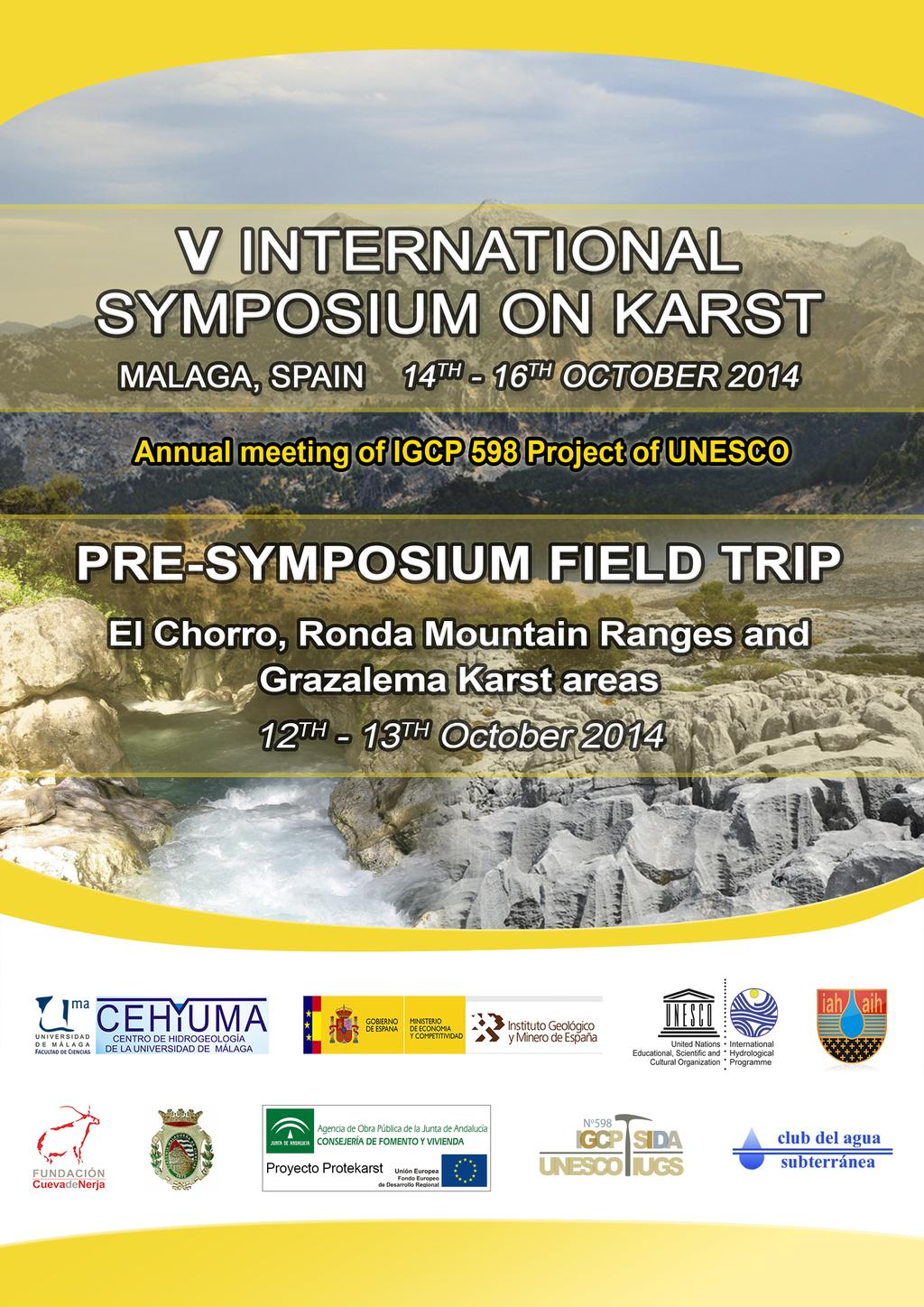
 Number of places: 12 (minimum) - 30 (maximum), by rigorous order of inscription Registration deadline: 1 st September 2014 Price: 160 /person Click here for registration General description The")
, the participants will have the opportunity to visit some of the most interesting Karst Systems in")
2 Pre-conference 2-day field trip to El Chorro, Ronda and Grazalema Karst systems Key features Departure: Sunday 12 th October (8.30 am) from Malaga city Return: Monday 13 th October (8:30 pm approx.) Number of places: 12 (minimum) - 30 (maximum), by rigorous order of inscription Registration deadline: 1 st September 2014 Price: 160 /person Click here for registration General description The pre-conference field trip will be held from the 12 th to the 13 th October 2014, prior to the 5 th International Symposium on Karst (ISKA). Guided by hydrogeologists from the Centre of Hydrogeology of the University of Málaga (CEHIUMA), the participants will have the opportunity to visit some of the most interesting Karst Systems in Western Betic Cordillera (Andalusia, S Spain): El Chorro and Gorge of the Gaitanes Ronda Mountain Range Grazalema Mountain Range Panoramic view of Endrinal and Pinar mountains (Grazalema Mountain Range) The area is constituted of Jurassic limestones and dolostones in which karstic processes have developed, giving rise to a great variety of karstic features such as springs with different hydrogeological functioning, karrenfields, sinkholes, dolines, uvalas and estavelles. During the visit to Grazalema Mountain Range area, the equipment recently installed to monitor the main discharge points of the aquifers will be shown. Doline at the contact between limestones and Flysch-type clays

")


3 Weather station recently installed in Grazalema area to monitor rainfall Conductivity and temperature sensor for continuous monitoring Water autosampler installed at Cornicabra spring (Ubrique, Grazalema Mountain Range) Capacitance water level probe for continuos flow discharge monitoring The trip will include lunch and dinner of the first day, one night in a three/four-star hotel in Ronda or Grazalema and breakfast and lunch of the second day. The details regarding accommodation will be confirmed in the following weeks. Panoramic view of Grazalema and Endrinal mountains from the Palomas pass (1350 m a.s.l.)


4 Provisional list of visits El Chorro and Gorge of the Gaitanes: the first stop of the field trip will be this spectacular area of high geological interest since it is located at the contact between the internal and external zones of the Betic Cordillera. Vertical Jurassic limestone layers overlaid with Miocene sandstones, water quality problems related to intense karstification on evaporite rocks, drainage of the Valle de Abdalajís karst aquifer because of the drilling of rail tunnels and the outstanding 700 m deep Gorge of the Gaitanes are just some of the features we will enjoy. Gorge of the Gaitanes Vertical layers of limestone at El Chorro Brine-water discharge area related to Triassic evaporite dissolution at the Guadalhorce reservoir s tail Contact between the internal and external zones of the Betic Cordillera (El Chorro) Carrizal spring: located at the edge of a nice travertine deposit where Cuevas del Becerro town settles down, this spring constitutes one of the main discharge points of the Merinos- Colorado-Carrasco carbonate aquifer system (Eastern Ronda mountains). Carrizal spring


 and general view of the Boyar pass and the Pinar mountains (below) Villaluenga del Rosario: this small town located at the eastern limit of Grazalema")
5 Hundidero-Gato Karstic system: it is a complex karstic system which comprises the infiltration of surface water (River Gaduares) into the Sierra de Líbar aquifer through the Hundidero sinkhole, rapid underground flow by large-scale fractures and drainage by the Gato spring. Hundidero sinkhole (left) and Cueva del Gato spring (right) Palomas pass viewpoint: after a gentle 10 minutes walk, we will reach the Palomas pass at m above sea level, from which we will enjoy one of the most beautiful views of Grazalema Mountain-Range at dusk. View and geological description from the Boyar pass: taking advantage of the nice view from this site, the major geological and hydrogeological characterristics of Sierra de Grazalema aquifer will be introduced. It will also be explained why despite being situated in Spain s Southernmost province, Grazalema receives the most rainfall quantity in all of Spain. Palomas pass (above) and general view of the Boyar pass and the Pinar mountains (below) Villaluenga del Rosario: this small town located at the eastern limit of Grazalema Mountain-Range, with the typical white houses of the area, hosts the 237 m deep m long Villaluenga swallow hole. We will walk into the entrance of the swallow hole and also visit the nearby Villaluenga Estavelle, located at the contact between the permeable Jurassic limestones and the impervious Miocene sandstones.
 and they are being monitored at the moment (flow rate,")

 Nueve Caños spring (Ubrique) Benamahoma spring: this spring, together with the")


6 Villaluenga swallow hole (left) and estavelle (right) Ubrique karst springs: Ubrique springs drain most of the Southeastern Grazalema aquifer resources (40 hm 3 /year) and they are being monitored at the moment (flow rate, electrical conductivity, temperature and turbidity records). Temporal evolutions of the main physico-chemical parameters show that, despite draining the same aquifer sector, these springs have very different hydrogeological functioning. Algarrobal spring (Ubrique) Nueve Caños spring (Ubrique) Benamahoma spring: this spring, together with the nearby Cachones overflow spring, constitute the main discharge points of Sierra de Grazalema aquifer, with a joint drainage of 31 hm 3 from November 2012 to September Benamahoma spring Cultural visits The field trip will permit the visit to some of the most beautiful Andalusian towns of the region: Ronda, Grazalema and Villaluenga del Rosario. Perched on an inland plateau riven by the 100 m fissure of El Tajo gorge, the elegant old town of Ronda holds a stunning architectural heritage as well as the history of bullfighting. Its plaza


7 de toros, in existence for more than 200 years, is one of the oldest and most revered bullrings in Spain. Ronda city El Tajo of Ronda Ronda s bullring Grazalema is a picture-postcard, red-tile-roofed village tucked into a corner of beautiful mountain country beneath the rock-climbers crag Peñón Grande. Local products include pure wool blankets and rugs, whose production follows centuries-old traditions. Finally, Villaluenga del Rosario is a picturesque white village of the interior of the Cádiz province well known for the production of craft goat's cheese called Payoyo. Grazalema town
, Ronda s bullring (www.andalucia.")
8 Location map All pictures by Centre of Hydrogeology of the University of Málaag except Ronda (Luis Marín), Ronda s bullring ( and Grazalema (Karan Jain).
Intra-symposium field trip to Torcal de Antequera and Alta Cadena Karst systems
 Intra-symposium field trip to Torcal de Antequera and Alta Cadena Karst systems Key features Departure: Wednesday 15 th October (8.30 am) from Malaga city (Hotel Malaga Palacio) Return: Same day 15 th
Field trip to Nerja Cave and coastal karst. Studies of Nerja cave and vadose and non-vadose zone
 Field trip to Nerja Cave and coastal karst. Studies of Nerja cave and vadose and non-vadose zone Key features Departure: Thursday 15th October (8.30 am) from Malaga city (Hotel Malaga Palacio) Return:
International Workshop on Groundwater Systems in Europe, August, 2013 Berlin
 Hydrogeological Mapping in Albania From the IHME contribution to larger scale national maps R. Eftimi, I. Tafilaj, G. Bisha & Xh. Sheganaku Mali me Gropa karst plateau Selita spring The hydrogeological
Geotechnical Engineering for Infrastructure and Development
 Proceedings of the XVI ECSMGE Geotechnical Engineering for Infrastructure and Development ISBN 978-0-7277-6067-8 The authors and ICE Publishing: All rights reserved, 2015 doi:10.1680/ecsmge.60678 Interaction
Karst found mostly in limestone (rock with at least 50% carbonate minerals), depends on 1) permeability & porosity
, depends on 1) permeability & porosity") KARST LANDFORMS produced by weathering & erosion in regions of carbonate rocks and evaporites processes called karstification mainly below ground surface predominantly underground drainage poorly-developed
KARST LANDFORMS produced by weathering & erosion in regions of carbonate rocks and evaporites processes called karstification mainly below ground surface predominantly underground drainage poorly-developed
Lecture 15: Subsidence
 Lecture 15: Subsidence Key Questions 1. How does removal of groundwater cause subsidence on a regional scale? 2. Under what conditions does a building sink into sediment? 3. Why do clays consolidate more
 12 10 8 6 4 2 0 40-50 50-60 60-70 70-80 80-90 90-100 Fresh Water What we will cover The Hydrologic Cycle River systems Floods Groundwater Caves and Karst Topography Hot springs Distribution of water in
EMERGENCY INVESTIGATION OF EXTREMELY LARGE SINKHOLES, MAOHE, GUANGXI, CHINA
 EMERGENCY INVESTIGATION OF EXTREMELY LARGE SINKHOLES, MAOHE, GUANGXI, CHINA Mingtang Lei, Xiaozhen Jiang, Zhende Guan Institute of Karst Geology, CAGS, Guilin, China, mingtanglei@hotmail.com Yongli Gao
LBJWC - Sinkhole Lesson
 LBJWC - Sinkhole Lesson Concept Caves and sinkholes are major openings in the ground that recharge water to the Edwards Aquifer. Objective - Students will: 1) identify a sinkhole, cave, fracture, fault,
David Gold Hiking Tours
 David Gold Hiking Tours Join us for a West Texas Active Adventure Tour February 14 21, 2017 Led by David Gold and Ulrike Porat The Big Bend area of West Texas is one of the most remote, and least visited
Science & Minerals of Switzerland Post-conference field trip (4 days, 3 nights)
") Science & Minerals of Switzerland Post-conference field trip (4 days, 3 nights) Dates: 24-27 August 2019 Group: 5-20 participants Price: 1080 Euro (including accommodation for three nights, foods, transportation,
Science & Minerals of Switzerland Post-conference field trip (4 days, 3 nights) Dates: 24-27 August 2019 Group: 5-20 participants Price: 1080 Euro (including accommodation for three nights, foods, transportation,
From Rodinia to Pangea: Geodynamics, Life and Climate
 IGCP 648 2018 Field Symposium in south China From Rodinia to Pangea: Geodynamics, Life and Climate Place: Yichang, Three Gorges region in South China Time: 2018, November 1-9 General information South
HID 362 MESLEKİ İNGİLİZCE 2
 HID 362 MESLEKİ İNGİLİZCE 2 Hafta 5 Prof. Dr. N. Nur ÖZYURT 2017-2018 Bahar Dönemi http://www.philippe-crochet.com/galerie/karst/details/18/lapiaz-et-sites-ruiniformes/236104/rr-14-0032-pic-saint-loupherault-figures-de-karstification-sur-la-crete-ouest
A Preliminary Geophysical Reconnaissance Mapping of Emirau Ground Water Resource, Emirau Island, New Ireland Province, PNG
 A Preliminary Geophysical Reconnaissance Mapping of Emirau Ground Water Resource, Emirau Island, New Ireland Province, PNG Geological Survey Division of Mineral Resources Authority (MRA) Papua New Guinea
Soluble rocks. November Overview. What are soluble rocks? What are the hazards from soluble rocks? What is the cost to the UK economy?
 Soluble rocks Overview Soluble (or karstic) rocks in the UK cause underground cavities leading to ground collapse, ranging from slight subsidence to dramatic sinkholes. These rocks, in increasing order
CCR Rule Compliance: Innovative Use of Geophysics to Certify Landfill Stability and Site Groundwater Monitoring Wells
 CCR Rule Compliance: Innovative Use of Geophysics to Certify Landfill Stability and Site Groundwater Monitoring Wells Gary Pendergrass, PE, RG Principal Geological Engineer Missouri Waste Control Coalition
Karst: multiple concepts for a unique geological object Dr Michel Bakalowicz
 Karst: multiple concepts for a unique geological object Dr Michel Bakalowicz Michel.Bakalowicz@gmail.com By way of an introduction The project of exploiting a lignite deposit in a limestone environment
INVESTIGATIONS OF LARGE SCALE SINKHOLE COLLAPSES, LAIBIN, GUANGXI, CHINA
 INVESTIGATIONS OF LARGE SCALE SINKHOLE COLLAPSES, LAIBIN, GUANGXI, CHINA Yongli Gao Department of Geological Sciences, Center for Water Research, University of Texas at San Antonio, TX 78249, USA, yongli.gao@utsa.edu
W I T H 18 Y E A R S OF E X P E R I E N C E IN T H E E D U C A T I O N S E C T O R, E X P L O R E C O L O M B I A IS T H E M O S T I M P O R T A N T
 W I T H 18 Y E A R S OF E X P E R I E N C E IN T H E E D U C A T I O N S E C T O R, E X P L O R E C O L O M B I A IS T H E M O S T I M P O R T A N T C O R P O R A T I O N IN C O L O M B I A S P E C I A
Solution Processes and. Karst Topography
 Solution Processes & Karst Topography Come forth into the light of things, Let Nature be your teacher. William Wordsworth 1 Solution Processes and Karst Topography The Impact of Solution Processes on the
WATER ON AND UNDER GROUND. Objectives. The Hydrologic Cycle
 WATER ON AND UNDER GROUND Objectives Define and describe the hydrologic cycle. Identify the basic characteristics of streams. Define drainage basin. Describe how floods occur and what factors may make
WESTCARB Phase I Results Review
 WESTCARB Phase I Results Review Arizona Geologic Characterization Errol Montgomery Principal Errol L. Montgomery & Associates (520) 881-4912 emontgomery@elmontgomery.com November 9, 2005 Site Characterization
PRECAMBRIAN CRYSTALLINE AQUIFER (METAMORPHIC ROCKS)
") HAYWARD QUADRANGLE: Groundwater Production by Aquifer In the 56-square-mile area of the Hayward Quadrangle, groundwater is produced from metamorphic crystalline rocks of the Precambrian basement (in the
HAYWARD QUADRANGLE: Groundwater Production by Aquifer In the 56-square-mile area of the Hayward Quadrangle, groundwater is produced from metamorphic crystalline rocks of the Precambrian basement (in the
Module 10: Resources and Virginia Geology Topic 4 Content: Virginia Geology Notes
 Virginia is composed of a very diverse landscape that extends from the beaches and barrier islands all of the way to the highly elevated Appalachian Plateau. Geologists have discovered ancient shallow
SWIM June 23-27, 2008 Naples, Florida USA Program and Proceedings Book
 SWIM June 23-27, 2008 Naples, Florida USA Program and Proceedings Book June 23-27, 2008 Naples, Florida, USA The Coastal Karstic Aquifer of Vlora (Albania) Maurizio Polemio 1, Arben Pambuku 2 and Olga
What we will cover. The Hydrologic Cycle. River systems. Floods. Groundwater. Caves and Karst Topography. Hot springs
 Fresh Water What we will cover The Hydrologic Cycle River systems Floods Groundwater Caves and Karst Topography Hot springs On a piece of paper, put these reservoirs of water in to order from largest to
Backroads to Beaufort
 Exploring Hidden South Carolina Backroads to Beaufort November 13 16 November is a great month to explore South Carolina s hidden Low Country, featuring one of the US s finest coastal gems Beaufort. We
PHOTO ALBUM KARST OF MIDDLE EAST
 PHOTO ALBUM KARST OF MIDDLE EAST by ZORAN STEVANOVIĆ 1 KARST OF NORTHERN IRAQ Iraqi territory lies in the border between two main geostructural units: Arabian part of African platform and Asian branches
An Hypothesis Concerning a Confined Groundwater Zone in Slopes of Weathered Igneous Rocks
 Symposium on Slope Hazards and Their Prevention: 8-10 May, 2000, Hong Kong, PRC An Hypothesis Concerning a Confined Groundwater Zone in Slopes of Weathered Igneous Rocks J. J. Jiao and A. W. Malone Department
Groundwater Rebound in the South Yorkshire Coalfield: A review of initial modelling
 Groundwater Rebound in the South Yorkshire Coalfield: A review of initial modelling 1 S. P. Burke, 1 H. A.B. Potter and 2 A. Jarvis 1 Environment Agency: Science Group, Olton Court, Olton,Solihull UK 2
Land subsidence due to groundwater withdrawal in Hanoi, Vietnam
 Land Subsidence (Proceedings of the Fifth International Symposium on Land Subsidence, The Hague, October 1995). 1AHS Publ. no. 234, 1995. 55 Land subsidence due to groundwater withdrawal in Hanoi, Vietnam
Development of geophysical investigation for verifying treatment efficiency of underground cavities
 Development of geophysical investigation for verifying treatment efficiency of underground cavities Hasan A. Kamal* Kuwait Institute for Scientific Research, Infrastructure Risk and Reliability Program,
A B O U T T H I S T R I P
 A B O U T T H I S T R I P 8 NIGHTS accommodation 14 MEALS 8 hot buffet breakfasts. 6 dinners. Join the von Trapps on an Austrian adventure that will make your heart sing, from Munich's medieval charm to
mountain rivers fixed channel boundaries (bedrock banks and bed) high transport capacity low storage input output
 high transport capacity low storage input output") mountain rivers fixed channel boundaries (bedrock banks and bed) high transport capacity low storage input output strong interaction between streams & hillslopes Sediment Budgets for Mountain Rivers Little
mountain rivers fixed channel boundaries (bedrock banks and bed) high transport capacity low storage input output strong interaction between streams & hillslopes Sediment Budgets for Mountain Rivers Little
Springshed Springshed Management Training Curriculum
 Springshed Springshed Management Training Curriculum Management Training Curriculum Draft Version 2 January 2016 The Springs Initiative 2016 The Springs Initiative SESSION TITLE: Mapping Springs in Crystalline
Groundwater. (x 1000 km 3 /y) Oceans Cover >70% of Surface. Groundwater and the. Hydrologic Cycle
 Oceans Cover >70% of Surface. Groundwater and the. Hydrologic Cycle") Chapter 17 Oceans Cover >70% of Surface Groundwater and the Hydrologic Cycle Vasey s Paradise, GCNP Oceans are only 0.025% of Mass Groundwater Groundwater is liquid water that lies in the subsurface in
Chapter 17 Oceans Cover >70% of Surface Groundwater and the Hydrologic Cycle Vasey s Paradise, GCNP Oceans are only 0.025% of Mass Groundwater Groundwater is liquid water that lies in the subsurface in
KARST LANDSCAPES Geology & Hydrology. Dr. Gerald E. Weber
 KARST LANDSCAPES Geology & Hydrology Dr. Gerald E. Weber Aerial Oblique Photograph of the UCSC Campus looking northwest Karst A type of topography that is formed on limestone, gypsum, and other soluble
CIRS - Hyblean Center for Speleo-Hydrogeological Research SECOND CIRCULAR ******************************************************************
 CIRS - Hyblean Center for Speleo-Hydrogeological Research Università di Catania Università di Messina SECOND CIRCULAR ****************************************************************** PRESENTATION AND
Preconference field trip (FT2) - Southern South Island Gold Fields
 - Southern South Island Gold Fields") Preconference field trip (FT2) - Southern South Island Gold Fields OVERVIEW: This field trip to the Otago and Southland goldfields, visits historic sites, and active mines and prospects. The trip will
Preconference field trip (FT2) - Southern South Island Gold Fields OVERVIEW: This field trip to the Otago and Southland goldfields, visits historic sites, and active mines and prospects. The trip will
Groundwater. (x 1000 km 3 /y) Reservoirs. Oceans Cover >70% of Surface. Groundwater and the. Hydrologic Cycle
 Reservoirs. Oceans Cover >70% of Surface. Groundwater and the. Hydrologic Cycle") Chapter 13 Oceans Cover >70% of Surface Groundwater and the Hydrologic Cycle Oceans are only 0.025% of Mass Groundwater Groundwater is liquid water that lies in the subsurface in fractures in rocks and
Chapter 13 Oceans Cover >70% of Surface Groundwater and the Hydrologic Cycle Oceans are only 0.025% of Mass Groundwater Groundwater is liquid water that lies in the subsurface in fractures in rocks and
ADVENTURES IN WATER DEVELOPED BY LOUISVILLE WATER COMPANY
 ADVENTURES IN WATER DEVELOPED BY LOUISVILLE WATER COMPANY Tunneling for Water explains the science behind a first-of-its-kind project in the world! Louisville Water Company is the first water utility
Today I will describe the groundwater/surface water interaction in the CRB in Mosier basin.
 Today I will describe the groundwater/surface water interaction in the CRB in Mosier basin. 1 Ken Lite, studying groundwater resource in Mosier basin since 1980 s (photo by A. Bouchier) 2012 with Jonathan
Second Circular The 11 th Workshop of the IAG/AIG SEDIBUD (Sediment Budgets in Cold Environments) Working Group
 Working Group") Second Circular The 11 th Workshop of the IAG/AIG SEDIBUD (Sediment Budgets in Cold Environments) Working Group "Relationships between climate change, vegetation cover and sediment fluxes in high latitude/high
Second Circular The 11 th Workshop of the IAG/AIG SEDIBUD (Sediment Budgets in Cold Environments) Working Group "Relationships between climate change, vegetation cover and sediment fluxes in high latitude/high
AWRA PMAS Engineers Club of Philadelphia. A Geologic Perspective on Stormwater
 AWRA PMAS Engineers Club of Philadelphia A Geologic Perspective on Stormwater Toby J. Kessler, P.G. Hydrogeologist Trevor G. Woodward, P.G. Engineering Geologist September 10, 2014 Gilmore & Associates,
resource and vulnerability Robineau & Join, nov
 Groundwater in tropical islands resource and vulnerability Robineau & Join, nov 2007 1 Diversity of hydrogeological environments in coastal areas of tropical islands : Hydrologic conditions (surface waters)
Geophysical Methods for Screening and Investigating Utility Waste Landfill Sites in Karst Terrain
 Geophysical Methods for Screening and Investigating Utility Waste Landfill Sites in Karst Terrain Gary Pendergrass, PE, RG, F.NSPE Principal Geological Engineer Kansas City Geotechnical Conference 2017
Introduction to Mapping
 Introduction to Mapping The Purpose of Maps A representation of a region of earth or heavens Informs the reader utilizing pictures Simple to read and interpret Aids in navigation 1 Earthquake Map Provides
news update August 2018 (No.6/18)
") news update August 2018 (No.6/18) Still the heat continues but should we complain? We ll soon get fed up with the rain when it returns, so make the most of it while it lasts, as many members did last weekend
news update August 2018 (No.6/18) Still the heat continues but should we complain? We ll soon get fed up with the rain when it returns, so make the most of it while it lasts, as many members did last weekend
Prof. Stephen A. Nelson EENS 111. Groundwater
 Page 1 of 8 Prof. Stephen A. Nelson EENS 111 Tulane University Physical Geology This page last updated on 20-Oct-2003 is water that exists in the pore spaces and fractures in rock and sediment beneath
Oceanography Field Trip One Key
 Oceanography Field Trip One Key If you are using this key as a make-up guide, you should get a COLOR version of this field trip guide by going to http://www.mpcfaculty.net/alfred_hochstaedter/oceanography.htm
Development and Application of Groundwater Flow and Solute Transport Models. Randolf Rausch
 Development and Application of Groundwater Flow and Solute Transport Models Randolf Rausch Overview Groundwater Flow Modeling Solute Transport Modeling Inverse Problem in Groundwater Modeling Groundwater
Geology 103 Planet Earth (QR II), Laboratory Exercises 1. Groundwater
, Laboratory Exercises 1. Groundwater") Geology 103 Planet Earth (QR II), Laboratory Exercises 1 Student Name: Section: Karst Landform: Groundwater Anyone who has viewed Chinese landscape scroll paintings will recognize that the mountains are
Geology 103 Planet Earth (QR II), Laboratory Exercises 1 Student Name: Section: Karst Landform: Groundwater Anyone who has viewed Chinese landscape scroll paintings will recognize that the mountains are
Hydrogeology of Karst NE Wisconsin. Dr. Maureen A. Muldoon UW-Oshkosh Geology Department
 Hydrogeology of Karst NE Wisconsin Dr. Maureen A. Muldoon UW-Oshkosh Geology Department WI Bedrock Outline Karst Landscapes Existing WQ Data Flow in Karst Aquifers Overview of Silurian Aquifer Water Level
Florida s Karst Geology
 Florida s Karst Geology Orange Creek Basin Interagency Working Group Public Workshop, November 5 th, 2015 Harley Means, P.G. Assistant State Geologist Florida Geological Survey Karst Karst a type of topography
JOURNAL OF ENVIRONMENTAL HYDROLOGY
 JOURNAL OF ENVIRONMENTAL HYDROLOGY The Electronic Journal of the International Association for Environmental Hydrology On the World Wide Web at http://www.hydroweb.com VOLUME 13 2005 THE EFFECT OF SINKHOLES
Pre-conference field trip (FT1) Geology and mineral deposits of New Caledonia
 Geology and mineral deposits of New Caledonia") Pre-conference field trip (FT1) Geology and mineral deposits of New Caledonia OVERVIEW: This trip is a rare opportunity to visit New Caledonia in northern Zealandia, a tropical paradise, and explore key
Pre-conference field trip (FT1) Geology and mineral deposits of New Caledonia OVERVIEW: This trip is a rare opportunity to visit New Caledonia in northern Zealandia, a tropical paradise, and explore key
Karst Topography In order to understand karst topography we must first have a basic understanding of the water cycle, the formation of limestone (carb
 Karst Topography The formation of caves and other associated features in limestone bedrock is called karst topography. Limestone, a sedimentary rock made mostly of the mineral calcite and small amounts
Chapter 14. Groundwater
 Chapter 14 Groundwater Importance of groundwater! Groundwater is water found in the pores of soil and sediment, plus narrow fractures in bedrock! Groundwater is the largest reservoir of fresh water that
6.1 Water. The Water Cycle
 6.1 Water The Water Cycle Water constantly moves among the oceans, the atmosphere, the solid Earth, and the biosphere. This unending circulation of Earth s water supply is the water cycle. The Water Cycle
Prentice Hall EARTH SCIENCE
 Prentice Hall EARTH SCIENCE Tarbuck Lutgens Running Water and Groundwater Running Water The Water Cycle Water constantly moves among the oceans, the atmosphere, the solid Earth, and the biosphere. This
The Niagara Escarpment extends from western New York, through the GTA all the way up to Manitoulin Island and into Michigan and Wisconsin.
 is southern Ontario s most prominent topographic feature, extending more than 500 kilometres from western New York, through Niagara Falls and the western part of the Greater Toronto Area (GTA), and north
A LETTER OF INFORMATION International field geo-cryological course for students and young scientists at the Kodar ridge in Zabaikalsky krai, Russia
 A LETTER OF INFORMATION International field geo-cryological course for students and young scientists at the Kodar ridge in Zabaikalsky krai, Russia The Industrial University of Tyumen (Department for Earth
10th International Workshop on Long-Term Changes and Trends in the Atmosphere
 First Circular 10th International Workshop on Long-Term Changes and Trends in the Atmosphere (TREND-2018) May 14-18 2018 Hefei, China (http://trends2018.ustc.edu.cn/home.html) The 10th International Workshop
GROUNDWATER OCCURRENCE IN KENYA
 GROUNDWATER OCCURRENCE IN KENYA Steven Okoth Owuor Ministry of Water and Sanitation Sunday, January 20, 2019 1 Geography INTRODUCTION The Republic of Kenya is located in East Africa The total area of the
Econfina Creek Springs
 Econfina Creek Springs Kris Barrios, NWFWMD FDEP IWRM Q-Meeting October 11, 2005 There are two Econfinas Econfina Creek: in my humble opinion, the finer of the two Econfina River: rhymes with bean Definition
FORMATION OF GROUNDWATER IN SEDIMENTARY BASINS: TRADITIONAL AND ALTERNATIVE MODELS
 FORMATION OF GROUNDWATER IN SEDIMENTARY BASINS: TRADITIONAL AND ALTERNATIVE MODELS Albertas Bitinas Klaipėda University, Coastal Research and Planning Institute, H. Manto St. 84, Klaipėda, Lithuania, albertas.bitinas@corpi.ku.lt
Yo u r i n c e n t i v e is i n s i d e. Sales Team
 Yo u r i n c e n t i v e is i n s i d e Sales Team W h y h o l d i n g y o u r n e x t i n c e n t i v e i n G e n e v a? 4 W h y h o l d i n g y o u r n e x t i n c e n t i v e i n G e n e v a? Why Geneva?
EARTH SCIENCE 11 CHAPTER 9 NOTES WATER MOVING UNDERGROUND
 EARTH SCIENCE 11 CHAPTER 9 NOTES WATER MOVING UNDERGROUND KEY A. ALL THE WORLD S WATER 1. The world has an estimated one and one third thousand million cubic kilometers of water. 2. The earth s water is
URBAN HYDROLOGY: WATER IN THE CITY OF TSHWANE Plant Sciences Auditorium, University of Pretoria January 2014 URBAN HYDROGEOLOGY
 URBAN HYDROLOGY: WATER IN THE CITY OF TSHWANE Plant Sciences Auditorium, University of Pretoria 23 24 January 2014 URBAN HYDROGEOLOGY MATTHYS A. DIPPENAAR DEPARTMENT GEOLOGY, UNIVERSITY OF PRETORIA HYDROGEOLOGY
2019/20 Rack Rates. 1 March 2019 to 29 February Updated: 08 March CHEM CHEM LODGE RATES PAGE 2 - LITTLE CHEM CHEM RATES PAGE 2
 1 March 2019 to 29 February 2020 Updated: 08 March 2018 - CHEM CHEM LODGE RATES PAGE 2 - LITTLE CHEM CHEM RATES PAGE 2 - FOREST CHEM CHEM RATES PAGE 2 - INCLUSIONS & EXCLUSIONS PAGE 3 - SPECIAL OFFERS,
DATA ACQUISITION METHODS FOR GROUNDWATER INVESTIGATION AND THE SITING OF WATER SUPPLY WELLS
 DATA ACQUISITION METHODS FOR GROUNDWATER INVESTIGATION AND THE SITING OF WATER SUPPLY WELLS M.B.J. Foster Tetra Tech EM Inc., San Francisco, CA, USA Keywords: Groundwater, water wells, drilled wells, geophysical
11/22/2010. Groundwater in Unconsolidated Deposits. Alluvial (fluvial) deposits. - consist of gravel, sand, silt and clay
 deposits. - consist of gravel, sand, silt and clay") Groundwater in Unconsolidated Deposits Alluvial (fluvial) deposits - consist of gravel, sand, silt and clay - laid down by physical processes in rivers and flood plains - major sources for water supplies
Groundwater in Unconsolidated Deposits Alluvial (fluvial) deposits - consist of gravel, sand, silt and clay - laid down by physical processes in rivers and flood plains - major sources for water supplies
Impact of the Danube River on the groundwater dynamics in the Kozloduy Lowland
 GEOLOGICA BALCANICA, 46 (2), Sofia, Nov. 2017, pp. 33 39. Impact of the Danube River on the groundwater dynamics in the Kozloduy Lowland Peter Gerginov Geological Institute, Bulgarian Academy of Sciences,
Soils, Hydrogeology, and Aquifer Properties. Philip B. Bedient 2006 Rice University
 Soils, Hydrogeology, and Aquifer Properties Philip B. Bedient 2006 Rice University Charbeneau, 2000. Basin Hydrologic Cycle Global Water Supply Distribution 3% of earth s water is fresh - 97% oceans 1%
INTRODUCTION. Climate
 INTRODUCTION Climate Landslides are serious natural disasters in many parts of the world. Since the past 30 years, rainfall triggered landslides and debris flows had been one of the natural disasters of
Subduction Zones and Bent Orogenic Belts of the Caribbean. From arc growth to orocline formation: The record from the Panama Canal and East Panama
 IUGS-UNESCO IGCP PROJECTS 546 Subduction Zones of the Caribbean and 574 Bending and Bent Orogens, and Continental Ribbons Workshop Subduction Zones and Bent Orogenic Belts of the Caribbean and Field Trip
JMO. İzmir, May 13, 2014
 JMO İzmir, May 13, 2014 1 The NECLIME Conference (2 th Circular) Dear colleagues and members of NECLIME, It is our pleasure to inform you that the 15 th Annual NECLIME Meeting will be in İzmir (Turkey)
The Capitan Aquifer - Ellenburger Production Wells Geothermal Engine Source?
 GEOTHERMAL ENERGY UTILIZATION ASSOCIATED WITH OIL & GAS DEVELOPMENT June 17-18, 2008 Southern Methodist University Dallas, Texas The Capitan Aquifer - Ellenburger Production Wells Geothermal Engine Source?
Conceptual models for karstic aquifers
 Speleogenesis and Evolution of Karst Aquifers The Virtual Scientific Journal www.speleogenesis.info Conceptual models for karstic aquifers William B. White Department of Geosciences and Materials Research
TAKING THE MYSTERY OUT OF USACE S ER DRILLING IN EARTH EMBANKMENT DAMS AND LEVEES
 TAKING THE MYSTERY OUT OF USACE S ER 1110-1-1807 DRILLING IN EARTH EMBANKMENT DAMS AND LEVEES 237 237 237 217 217 217 200 200 200 80 119 27 252 174.59 1 255 255 255 0 0 0 163 163 163 131 132 122 239 65
-Sharing concepts and techniques among Switzerland, Japan, Taiwan, and other SBT-leading countries-
 A short report on the 2 nd International Workshop on Sediment Bypass Tunnels -Sharing concepts and techniques among Switzerland, Japan, Taiwan, and other SBT-leading countries- The 2 nd International Workshop
Chapter 8 Fetter, Applied Hydrology 4 th Edition, Geology of Groundwater Occurrence
 Chapter 8 Fetter, Applied Hydrology 4 th Edition, 2001 Geology of Groundwater Occurrence Figure 8.42. Alluvial Valleys ground-water region. Fetter, Applied Hydrology 4 th Edition, 2001 Fetter, Applied
Follow this and additional works at: Part of the Geology Commons
 Western Michigan University ScholarWorks at WMU Michigan Geological Repository for Research and Education Geosciences 2016 Geology of Michigan William B. Harrison III Michigan Geological Repository for
MUHAMMAD S TAMANNAI, DOUGLAS WINSTONE, IAN DEIGHTON & PETER CONN, TGS Nopec Geological Products and Services, London, United Kingdom
 Geological and Geophysical Evaluation of Offshore Morondava Frontier Basin based on Satellite Gravity, Well and regional 2D Seismic Data Interpretation MUHAMMAD S TAMANNAI, DOUGLAS WINSTONE, IAN DEIGHTON
Can you remember? What type of river the Nidd is? Why the water turns things to stone? What happened when the viaduct collapsed in 1848?
 rivers & rocks Can you remember? What type of river the Nidd is? Why the water turns things to stone? What happened when the viaduct collapsed in 1848? How the weir was used? How the cave was formed? Let
LANDFORM REGIONS IN CANADA. Classroom Notes and Descriptions
 LANDFORM REGIONS IN CANADA Classroom Notes and Descriptions Landform Regions in Canada There are eight distinct landforms in Canada: Western Cordillera Region Interior Plains Canadian Shield Hudson Bay
XXXVIII IAH Congress
 XXXVIII IAH Congress Groundwater Quality Sustainability Krakow, 12 17 September 2010 Extended Abstracts Editors: Andrzej Zuber Jarosław Kania Ewa Kmiecik University of Silesia Press 2010 abstract id: 155
B. T. Brady, M. S. Bedinger, John Mikels, William H. Langer, and Deborah A. Mulvihill
 DEPARTMENT OF THE INTERIOR UNITED STATES GEOLOGICAL SURVEY TO ACCOMPANY WRI REPORT 83-4121-B MAP SHOWING GROUND-WATER LEVELS, SPRINGS. AND DEPTH TO GROUND WATER, BASIN AND RANGE PROVINCE, TEXAS by B. T.
Introduction The Exam...vii. 1. Maps and Photographs...1
 CONTENTS Introduction The Exam...vii Section 1...vii Section 2...viii 1. Maps and Photographs...1 Grid references on maps...1 Scale and measuring distance...3 Directions on maps...5 Area on maps...6 Height
Monday 2 June 2014 Morning
 Monday 2 June 2014 Morning A2 GCE GEOLOGY F794/01 Environmental Geology *3076922876* Candidates answer on the Question Paper. OCR supplied materials: None Other materials required: Electronic calculator
3.0 GEOLOGY AND HYDROGEOLOGY
 3.0 GEOLOGY AND HYDROGEOLOGY 3.1 Methodology The Geological Survey of Ireland (GSI) publication Geology of South Cork was consulted to establish the nature of the bedrock lithology and Quaternary sediments.
European Solar Days May Report Spain
 European Solar Days 2009 12-22 May Report Spain Support by: 1 Results of European Solar Days 2009 in Spain 1.1. Participation in European Solar Days 2009 The 2 nd Edition of the European Solar Days organised
Ground-Water Flow through Porous Medium. GEO 321 Lecture 14 Dr. J. S. Kite. Groundwater, Karst, and Caves
 GEO 321 Lecture 14 Dr. J. S. Kite The Rock Organ Organ Cave, Greenbrier Co., WV Groundwater, Karst, and Caves Soil & Ground Water Distribution Eastern USA Soil Moisture Belt Unsaturated (Aeration) Zone
Jurassic Coast Fieldtrip
 Field trip leaders: Members of the convener team Dates: Thursday 11 th and Friday 12 th April Jurassic Coast Fieldtrip Logistics: Note that the field trip will begin and end in Piccadilly, London (in front
2014 Summer training course for slope land disaster reduction Taipei, Taiwan, Aug
 MINISTRY OF SCIENCE AND TECHNOLOGY HYDROTECH RESEARCH INSTITUTE MINISTRY OF NATURAL RESOURCES AND ENVIRONMENT VIETNAM INSTITUTE OF GEOSCIENCES AND MINERAL RESOURCES (VIGMR) 2014 Summer training course
Bulletin of the Geological Society of Greece
 Bulletin of the Geological Society of Greece Vol. 43, 2010 BRACKISH KARST SPRINGS SIMULATION WITH MODKARST MODEL UNDER NOT ENOUGH DATA CONDITIONS (THE CASE OF THE POTAMI SPRING AT HIMARA ALBANIA) Maramathas
STUDY GUIDE FOR CONTENT MASTERY. Movement and Storage of Groundwater
 Groundwater SECTION 10.1 Movement and Storage of Groundwater In your textbook, read about the hydrosphere, precipitation and groundwater, and groundwater storage. Use the following terms to complete the
Lecture Outlines PowerPoint. Chapter 5 Earth Science 11e Tarbuck/Lutgens
 Lecture Outlines PowerPoint Chapter 5 Earth Science 11e Tarbuck/Lutgens 2006 Pearson Prentice Hall This work is protected by United States copyright laws and is provided solely for the use of instructors
The UK GeoEnergy Test Bed Ceri J Vincent British Geological Survey
 The UK GeoEnergy Test Bed Ceri J Vincent British Geological Survey Thanks to Matthew Hall (GTB Theme Lead for G ERA), Phil Meldrum, Russell Swift, Oliver Kuras, Richard Luckett, Andrew Butcher, Jonathan
Fossils and Geology of Litzsinger Road Ecology Center
 Fossils and Geology of Litzsinger Road Ecology Center Table of Content Key Terms 1 Key Terms 2 What you need to know Geologic Map of Missouri Geologic Time Chart More of what you need to know Digital map