Field trip to Nerja Cave and coastal karst. Studies of Nerja cave and vadose and non-vadose zone
|
|
|
- Cleopatra Nichols
- 6 years ago
- Views:
Transcription
1
 from Malaga city (Hotel Malaga Palacio) Return: Thursday 15th October (7:00 pm approx.")
.")
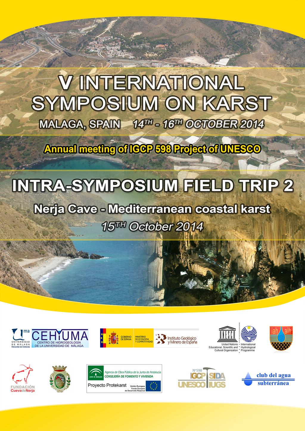
2 Field trip to Nerja Cave and coastal karst. Studies of Nerja cave and vadose and non-vadose zone Key features Departure: Thursday 15th October (8.30 am) from Malaga city (Hotel Malaga Palacio) Return: Thursday 15th October (7:00 pm approx.) Number of places: 50 (maximum), by rigorous order of inscription Registration deadline: 1st September 2014 The trip will include lunch at the restaurant of Nerja Cave General description The field trip will be the 15th October 2014, during the celebration of the 5th International Symposium on Karst (ISKA). Guided by hydrogeologists from the Centre of Hydrogeology of the University of Málaga (CEHIUMA), the participants will have the opportunity to visit one of the most spectacular examples of subterranean landscape of the south of Spain: the Nerja Cave (Andalusia, Málaga), situated less than 1 km from the Mediterranean sea. The main goals of this excursion are to present the principal characteristics of the endokarst in this part of the Mediterranean, and the considerable interest for geologic research of these forms and sediments. We shall contemplate their origin with respect to the palaeohydrology of the zone, the contemporary hydrogeologic factors that influence the surroundings and the environmental controls that are being implemented. Panoramic view of Nerja Cave surroundings: the Natural Park of the Maro-Cerro Gordo Cliffs ( left) and the Natural Park Tejeda- Almijara Alhama (right). The Nerja Cave, a Good of Cultural Interest, in the category of Archaeological Place and a Geosites internationally recognized, is one of the most important tourist caves in Spain, with about 500,000 visitors annually. Its popularity is influenced by its location
.")
3 in a major tourist zone (Costa del Sol) and naturally by the beauty of the chambers and speleothems that can be found there. Panoramic view of Nerja Cave From a geological viewpoint, the cave lies within rocks belonging to the Almijara Unit (Alpujarride Complex, Betic Cordillera). The stratigraphic series of this Unit is made up of a lower metapelitic succession and of an overlying carbonate sequence, constituted of dolomitic marbles (in which the cave developed) and calcareous marbles toward the top. Endokarstic forms of certain significance are fairly rare in the Alpujarride carbonate aquifers; the Nerja Cave is a major exception. Today, the cave is situated in the unsaturated zone of the aquifer, several metres above the piezometric level, as a consequence of the tectonic lifting of the region during the Pliocene and the Quaternary. Numerous researches have been conducted in the Nerja Cave, almost since its discovery. The cave has several microclimatic stations comprising various sensors that measure, through time intervals, temperature, relative humidity and air concentration of 222 Rn and CO 2, among other parameters. Furthermore, a weather station measures the environmental parameters outside the cave. This network system allows to knowing and studying the natural changes of the cave and the changes produced by the visitors. Hydrogeological studies have been carried out within Nerja Cave since 1991 to characterise the dripwater within the cavity, both chemically and isotopically, and to determine the hydrodynamic functioning of the unsaturated zone of the aquifer in which it lies. In Nerja Cave also it have been done biological researches about the biofilms, which appear at places in the cavity where light and water coexist, about the microbiology of the air and of the water of the cave and about the fauna.


4 An experimental karst site is located in the immediate vicinity of the Nerja Cave, with access to 10 boreholes. Air temperature, relative humidity and CO 2 concentrations are the main variables registered, especially their variations with the depth in the boreholes. The measurements point out to average vadose air CO 2 concentrations of near 40,000 ppm, and maximum of near 60,000 ppm. In this context, the cave appears as a vadose subsystem above the groundwater level, with significantly less concentration of CO 2 due to its important natural ventilation. Nowadays, all these researches being carried out are part of an ambitious Interdisciplinar Research Project to preserve the Nerja Cave. Its main aims are to determine the pressure and factors affecting the Nerja cave, to preserve the cultural and natural heritage of the cave and to design a management system based on research, preservation and diffusion. Provisional list of stops Nerja Cave: spectacular tourist cave of high interest geological and archaeological. Beautiful subterranean karstic landscape, several types of speleothems, microclimatic stations, weather station and geological and hydrogeological researches developed in the cavity from its discover are just some of the topics and features we will enjoy during the visit. Monitoring network of Nerja Cave: weather station of the cave, on the left and microclimatic and hydrogeological station inside the cave, on the right. Experimental karst site of Nerja Cave: we will present the results of the monitoring of the subsurface air CO 2 concentrations in the experimental field site near the Nerja Cave. The systematic measurements of the CO 2 content of the air in the vadose environment are based on a number of boreholes, most of them having a depth of 30 m. From 2013, the experimental site has a station with a datalogger and different probes measure the temperature, humidity, CO 2 and direction and speed of the air flow in one of the borehole.


5 Vertical profiles of CO 2 in boreholes (left) and air control station at point 4 with data-logger and probes of temperature, humidity, CO 2, direction and speed of air (right). View and geological-hydrogeological description of the coastal sector of Nerja: in this stop, the major hydrogeological characteristics of Sierra Almijara aquifer will be introduced. The coastal sectors of Nerja, Cantarriján, Cerro Gordo and Punta de la Mona constitute part of the mass of underground water of Alberquillas, which is made up of a set of outcropping marbles. The southern boundary of the aquifer is defined by fault systems that are WNW-ESE and NW-SE directional, and separate the marbles from the alpujárride schists of low permeability. Cerro Gordo constitutes the southeastern end of the Alberquillas block. This outcrop of marbles has a sharp outline, with an enormous cliff 150 meters high that sinks some 20 meters below the surface of the Mediterranean Sea. In the rock walls, the continuous erosive action of the sea has dug a series of shallow grottos.
 of the aquifer where the Nerja cave is located.")

, constructed in the 19th century to irrigate the former sugar cane plantations and to transport")
6 Overview of the coast of Nerja, with Cerro Gordo in the background. Maro spring: the major hydrogeological characteristics of Sierra Almijara aquifer will be introduced. It will also be explained the principal characteristics of Maro spring, the main point of discharge (300 L/s) of the aquifer where the Nerja cave is located. Industrial Heritage: water has always been tied to the economic development of this region, as shown by the varied infrastructures that exist for its collection and use: irrigation channels, pools and reservoirs. In addition there are two historic constructions, true gems of the local industrial patrimony: the Paper Mill (Molino de Papel), a paper factory built on the shores of the Río de la Miel in the 18th century; and the Eagle s Aqueduct (Acueducto del Águila), constructed in the 19th century to irrigate the former sugar cane plantations and to transport water to the refinery of San Joaquín de Maro. On the left, waters of Maro spring. On the right, Acueducto del Águila, an important element of the local industrial heritage
Intra-symposium field trip to Torcal de Antequera and Alta Cadena Karst systems
 Intra-symposium field trip to Torcal de Antequera and Alta Cadena Karst systems Key features Departure: Wednesday 15 th October (8.30 am) from Malaga city (Hotel Malaga Palacio) Return: Same day 15 th
Pre-conference 2-day field trip to El Chorro, Ronda and Grazalema Karst systems
 Pre-conference 2-day field trip to El Chorro, Ronda and Grazalema Karst systems Key features Departure: Sunday 12 th October (8.30 am) from Malaga city Return: Monday 13 th October (8:30 pm approx.) Number
Geotechnical Engineering for Infrastructure and Development
 Proceedings of the XVI ECSMGE Geotechnical Engineering for Infrastructure and Development ISBN 978-0-7277-6067-8 The authors and ICE Publishing: All rights reserved, 2015 doi:10.1680/ecsmge.60678 Interaction
Chapter 14: Groundwater. Fig 14.5b
 Chapter 14: Groundwater Fig 14.5b OBJECTIVES Recognize that groundwater is a vital source of accessible freshwater. Describe how groundwater forms below the water table. Explain the origin of aquifers,
CIRS - Hyblean Center for Speleo-Hydrogeological Research SECOND CIRCULAR ******************************************************************
 CIRS - Hyblean Center for Speleo-Hydrogeological Research Università di Catania Università di Messina SECOND CIRCULAR ****************************************************************** PRESENTATION AND
Grounds. (*) Arouca Declaration; International Congress of Geotourism, Arouca Geopark, Portugal, Nov
 Arouca Declaration; International Congress of Geotourism, Arouca Geopark, Portugal, Nov") Grounds In the past few years, Latin America has witnessed increasing actions intended to conceive and develop geoparks, mainly as a result of the initiative promoted by the UNESCO Geoscience and Geoparks
Grounds In the past few years, Latin America has witnessed increasing actions intended to conceive and develop geoparks, mainly as a result of the initiative promoted by the UNESCO Geoscience and Geoparks
URBAN HYDROLOGY: WATER IN THE CITY OF TSHWANE Plant Sciences Auditorium, University of Pretoria January 2014 URBAN HYDROGEOLOGY
 URBAN HYDROLOGY: WATER IN THE CITY OF TSHWANE Plant Sciences Auditorium, University of Pretoria 23 24 January 2014 URBAN HYDROGEOLOGY MATTHYS A. DIPPENAAR DEPARTMENT GEOLOGY, UNIVERSITY OF PRETORIA HYDROGEOLOGY
LBJWC - Sinkhole Lesson
 LBJWC - Sinkhole Lesson Concept Caves and sinkholes are major openings in the ground that recharge water to the Edwards Aquifer. Objective - Students will: 1) identify a sinkhole, cave, fracture, fault,
GEO-STABILITY DESKTOP STUDY FOR A PROPOSED FILLING STATION AT ROODEKRANS MOGALE CITY, GAUTENG
 GEO-STABILITY DESKTOP STUDY FOR A PROPOSED FILLING STATION AT ROODEKRANS MOGALE CITY, GAUTENG Page 1 of 11 GEO-STABILITY DESKTOP STUDY FOR A PROPOSED FILLING STATION AT ROODEKRANS MOGALE CITY, GAUTENG
International Workshop on Groundwater Systems in Europe, August, 2013 Berlin
 Hydrogeological Mapping in Albania From the IHME contribution to larger scale national maps R. Eftimi, I. Tafilaj, G. Bisha & Xh. Sheganaku Mali me Gropa karst plateau Selita spring The hydrogeological
Karst found mostly in limestone (rock with at least 50% carbonate minerals), depends on 1) permeability & porosity
, depends on 1) permeability & porosity") KARST LANDFORMS produced by weathering & erosion in regions of carbonate rocks and evaporites processes called karstification mainly below ground surface predominantly underground drainage poorly-developed
KARST LANDFORMS produced by weathering & erosion in regions of carbonate rocks and evaporites processes called karstification mainly below ground surface predominantly underground drainage poorly-developed
Saline water intrusion monitoring and control at Guves Prefecture - Crete
 Saline water intrusion monitoring and control at Guves Prefecture - Crete G-Akis Tselentis% George Kallergis*, Iraklis Bulukakis^, George Delis* and Paraskevas Paraskevopoulos* (1) University of Patras,
AWRA PMAS Engineers Club of Philadelphia. A Geologic Perspective on Stormwater
 AWRA PMAS Engineers Club of Philadelphia A Geologic Perspective on Stormwater Toby J. Kessler, P.G. Hydrogeologist Trevor G. Woodward, P.G. Engineering Geologist September 10, 2014 Gilmore & Associates,
Chapter 14. Groundwater
 Chapter 14 Groundwater Importance of groundwater! Groundwater is water found in the pores of soil and sediment, plus narrow fractures in bedrock! Groundwater is the largest reservoir of fresh water that
Chapter 2 Water Flow in Rock: Geometry of Water Conducting Paths and Lugeon-Values
 Chapter 2 Water Flow in Rock: Geometry of Water Conducting Paths and Lugeon-Values Each rock mass has its own pattern of water bearing paths. In Germany, in the 1970s the term Wasserwegsamkeit was in common
11/22/2010. Groundwater in Unconsolidated Deposits. Alluvial (fluvial) deposits. - consist of gravel, sand, silt and clay
 deposits. - consist of gravel, sand, silt and clay") Groundwater in Unconsolidated Deposits Alluvial (fluvial) deposits - consist of gravel, sand, silt and clay - laid down by physical processes in rivers and flood plains - major sources for water supplies
Groundwater in Unconsolidated Deposits Alluvial (fluvial) deposits - consist of gravel, sand, silt and clay - laid down by physical processes in rivers and flood plains - major sources for water supplies
INVESTIGATIONS OF LARGE SCALE SINKHOLE COLLAPSES, LAIBIN, GUANGXI, CHINA
 INVESTIGATIONS OF LARGE SCALE SINKHOLE COLLAPSES, LAIBIN, GUANGXI, CHINA Yongli Gao Department of Geological Sciences, Center for Water Research, University of Texas at San Antonio, TX 78249, USA, yongli.gao@utsa.edu
Coastal erosion and instability phenomena at Stara Baška, Krk Island, Croatia
 Conférence Méditerranéenne Côtière et Maritime EDITION 4, SPLIT, CROATIA (2017) Coastal and Maritime Mediterranean Conference Disponible en ligne http://www.paralia.fr Available online Coastal erosion
Holocene evolution of Dahab coastline Gulf of Aqaba, Sinai Peninsula, Egypt 1
 Holocene evolution of Dahab coastline Gulf of Aqaba, Sinai Peninsula, Egypt 1 Magdy Torab* 2 * Prof. of Geomorphology, Department of Geography, Damanhour University, Egypt 3 E-mail: magdytorab@hotmail.com.
Effects of depositional and diagenetic heterogeneitites on fluid flow in Plio -- Pleistocene reefal carbonates of the Southern Dominican Republic
 Viviana Díaz was born in Puerto Rico and received her undergraduate degree from the University of Puerto Rico and her Master's at the University of North Carolina. She is currently working on her PhD at
Preconference field trip (FT2) - Southern South Island Gold Fields
 - Southern South Island Gold Fields") Preconference field trip (FT2) - Southern South Island Gold Fields OVERVIEW: This field trip to the Otago and Southland goldfields, visits historic sites, and active mines and prospects. The trip will
Preconference field trip (FT2) - Southern South Island Gold Fields OVERVIEW: This field trip to the Otago and Southland goldfields, visits historic sites, and active mines and prospects. The trip will
Geology 103 Planet Earth (QR II), Laboratory Exercises 1. Groundwater
, Laboratory Exercises 1. Groundwater") Geology 103 Planet Earth (QR II), Laboratory Exercises 1 Student Name: Section: Karst Landform: Groundwater Anyone who has viewed Chinese landscape scroll paintings will recognize that the mountains are
Geology 103 Planet Earth (QR II), Laboratory Exercises 1 Student Name: Section: Karst Landform: Groundwater Anyone who has viewed Chinese landscape scroll paintings will recognize that the mountains are
Blanca Payàs 1, Ryan Morris 2, Alain Arnaud 1, David Albiol 1, John Bradshaw 3, Javier Duro 1. Abstract
 Surface monitoring using radar satellite images to measure ground deformation: applied to Coal Seam Gas production areas to comply with regulatory requirements Blanca Payàs 1, Ryan Morris 2, Alain Arnaud
Real-time prediction during TBM advance.
 Real-time prediction during TBM advance. Risk management through the BEAM in Doha Metro Project F. Bove Seli Overseas S.p.A., Rome, Italy. R. Grandori Seli Overseas S.p.A., Rome, Italy. ABSTRACT: The Bore
XXXVIII IAH Congress
 XXXVIII IAH Congress Groundwater Quality Sustainability Krakow, 12 17 September 2010 Extended Abstracts Editors: Andrzej Zuber Jarosław Kania Ewa Kmiecik University of Silesia Press 2010 abstract id: 155
New GCSE Geography AQA
 Learning Checklist Half Term 1 26 th September 3 rd October 10 th October 17 th October 1.1.1 Tectonic Hazards Plate tectonics theory. Global distribution of earthquakes and volcanic eruptions and their
3.0 GEOLOGY AND HYDROGEOLOGY
 3.0 GEOLOGY AND HYDROGEOLOGY 3.1 Methodology The Geological Survey of Ireland (GSI) publication Geology of South Cork was consulted to establish the nature of the bedrock lithology and Quaternary sediments.
Module 10: Resources and Virginia Geology Topic 4 Content: Virginia Geology Notes
 Virginia is composed of a very diverse landscape that extends from the beaches and barrier islands all of the way to the highly elevated Appalachian Plateau. Geologists have discovered ancient shallow
SEA LIFE Sydney Aquarium. Penguin Expedition Self-Guided Resource Kit. Secondary 7-10
 SEA LIFE Sydney Aquarium Penguin Expedition Self-Guided Resource Kit Secondary 7-10 Introduction The following material has been developed by the SEA LIFE Sydney Aquarium Education Team to support our
A Level Geography Cambridge International Content Programme For teaching from September 2016
 A Level Geography Cambridge International Content Programme For teaching from September 2016 is located on the Start Bay coast in South Devon and is surrounded by Slapton Ley National Nature Reserve. The
Jurassic Coast Fieldtrip
 Field trip leaders: Members of the convener team Dates: Thursday 11 th and Friday 12 th April Jurassic Coast Fieldtrip Logistics: Note that the field trip will begin and end in Piccadilly, London (in front
Geotechnical Deskstudy for Proposed Windfarm NV NORDISK VINDKRAFT AB. Fjällberg. Östersund , rev Fjällberg
 NV NORDISK VINDKRAFT AB Östersund 23-06-2011, rev 06-07-2012 Geotechnical Deskstudy for Proposed Windfarm Date 23-06-2011, rev 06-07-2012 Project number 61811144691000 JONSSON EVA TAJANI KRISTINA TAJANI
Soluble rocks. November Overview. What are soluble rocks? What are the hazards from soluble rocks? What is the cost to the UK economy?
 Soluble rocks Overview Soluble (or karstic) rocks in the UK cause underground cavities leading to ground collapse, ranging from slight subsidence to dramatic sinkholes. These rocks, in increasing order
A Preliminary Geophysical Reconnaissance Mapping of Emirau Ground Water Resource, Emirau Island, New Ireland Province, PNG
 A Preliminary Geophysical Reconnaissance Mapping of Emirau Ground Water Resource, Emirau Island, New Ireland Province, PNG Geological Survey Division of Mineral Resources Authority (MRA) Papua New Guinea
Surface Processes Focus on Mass Wasting (Chapter 10)
") Surface Processes Focus on Mass Wasting (Chapter 10) 1. What is the distinction between weathering, mass wasting, and erosion? 2. What is the controlling force in mass wasting? What force provides resistance?
Surface Processes Focus on Mass Wasting (Chapter 10) 1. What is the distinction between weathering, mass wasting, and erosion? 2. What is the controlling force in mass wasting? What force provides resistance?
Evaluating Geological Formations and Managing Ground-Water Resources: Can We Afford the Effort?
 Evaluating Geological Formations and Managing Ground-Water Resources: Can We Afford the Effort? Stanley T. Paxton & Todd Halihan Oklahoma State University GSA Annual Meeting Salt Lake City, Utah 16-19
Although most karstic regions
 Urban Geophysics: Geophysical Signature of Mount Bonnell Fault and Its Karstic Features in Austin, TX by Mustafa Saribudak, Environmental Geophysics Associates, Austin, TX Although most karstic regions
Hydrogeology of Karst NE Wisconsin. Dr. Maureen A. Muldoon UW-Oshkosh Geology Department
 Hydrogeology of Karst NE Wisconsin Dr. Maureen A. Muldoon UW-Oshkosh Geology Department WI Bedrock Outline Karst Landscapes Existing WQ Data Flow in Karst Aquifers Overview of Silurian Aquifer Water Level
» Kras Geopark in the Project KRAS-CARSO«
 » Kras Geopark in the Project KRAS-CARSO«Martina Stupar, B.Sc.Geology Nature conservation consultant Geoconference»Emerging new geoparks in Europe sharing knowledge & good examples«mežica, 21. November
The Late Quaternary Rio Grande Delta A Distinctive, Underappreciated Geologic System
 The Late Quaternary Rio Grande Delta A Distinctive, Underappreciated Geologic System Thomas E. Ewing 1 and Juan L. Gonzalez 2 1 Frontera Exploration Consultants, 19240 Redland Rd., Ste. 250, San Antonio,
Third International Conference on Learning Cities Global goals, local actions: Towards lifelong learning for all in 2030.
 Environmental, urban, and individual regeneration in former mining landscapes of the Sulcis-Iglesiente area: the role of Geo-minerary Park in fostering a learning city Third International Conference on
SEMESTER AT SEA COURSE SYLLABUS
 SEMESTER AT SEA COURSE SYLLABUS Short Term Voyage - May 2012 Discipline: Geology EVSC 2559-101: Geology of Central America: Setting, Resources, and Hazards Division: Lower Division Faculty Name: Catherine
Excursion guide NW Skåne, NGEA 01, 2018 PART 3. ASSIGNMENTS
 Excursion guide NW Skåne, NGEA 01, 2018 PART 3. ASSIGNMENTS by Associate Prof. Jonas Åkerman 1 Cover photo; The NW exposed coastline at Josefinelust with coarse beach boulders (Sw. malar ), gneiss is the
Newsletter # 2. Pilot sites in Greece. December 2018
 A HarmonizEd framework to Mitigate coastal EroSion promoting ICZM protocol implementation Newsletter # 2 December 2018 View of a beach in Ammolofi ( Paggaio Municipality ) Pilot sites in Greece 1. Name
Hydrogeological evaluation of Valongo (Porto), Paredes (Porto) and Arouca (Aveiro) areas, based on spring hydrograph analysis
, Paredes (Porto) and Arouca (Aveiro) areas, based on spring hydrograph analysis") Hydrogeological evaluation of Valongo (Porto), Paredes (Porto) and Arouca (Aveiro) areas, based on spring hydrograph analysis Eduardo Gonçalves PhD student of Geosciences (concluded in 2013) Departamento
Hydrogeological evaluation of Valongo (Porto), Paredes (Porto) and Arouca (Aveiro) areas, based on spring hydrograph analysis Eduardo Gonçalves PhD student of Geosciences (concluded in 2013) Departamento
Prof. Stephen A. Nelson EENS 111. Groundwater
 Page 1 of 8 Prof. Stephen A. Nelson EENS 111 Tulane University Physical Geology This page last updated on 20-Oct-2003 is water that exists in the pore spaces and fractures in rock and sediment beneath
Geomonumental Routes: a useful tool for the popularization of Architectural Heritage
 Geomonumental Routes: a useful tool for the popularization of Architectural Heritage E.M. Perez-Monserrat 1, M.J. Varas 2, M. Gomez-Heras 1, M. Alvarez de Buergo 1, R. Fort 1 1 Institute of Economic Geology
The Capitan Aquifer - Ellenburger Production Wells Geothermal Engine Source?
 GEOTHERMAL ENERGY UTILIZATION ASSOCIATED WITH OIL & GAS DEVELOPMENT June 17-18, 2008 Southern Methodist University Dallas, Texas The Capitan Aquifer - Ellenburger Production Wells Geothermal Engine Source?
Science & Minerals of Switzerland Post-conference field trip (4 days, 3 nights)
") Science & Minerals of Switzerland Post-conference field trip (4 days, 3 nights) Dates: 24-27 August 2019 Group: 5-20 participants Price: 1080 Euro (including accommodation for three nights, foods, transportation,
Science & Minerals of Switzerland Post-conference field trip (4 days, 3 nights) Dates: 24-27 August 2019 Group: 5-20 participants Price: 1080 Euro (including accommodation for three nights, foods, transportation,
Multi-scale evaluations of submarine groundwater discharge
 doi:10.5194/piahs-365-66-2015 66 Complex Interfaces Under Change: Sea River Groundwater Lake Proceedings of HP2/HP3, IAHS-IAPSO-IASPEI Assembly, Gothenburg, Sweden, July 2013 (IAHS Publ. 365, 2014). Multi-scale
Structural Geology Lab. The Objectives are to gain experience
 Geology 2 Structural Geology Lab The Objectives are to gain experience 1. Drawing cross sections from information given on geologic maps. 2. Recognizing folds and naming their parts on stereoscopic air
GEOLOGY (GEOL) Geology (GEOL) 1. GEOL 118 Societal Issues in Earth Science (4 crs)
 Geology (GEOL) 1. GEOL 118 Societal Issues in Earth Science (4 crs)") Geology (GEOL) 1 GEOLOGY (GEOL) GEOL 102 Oceanography (3 crs) Survey of the world oceans with emphasis on geologic processes. Also includes chemical, physical, and biological aspects of the sea. Investigates
Geology (GEOL) 1 GEOLOGY (GEOL) GEOL 102 Oceanography (3 crs) Survey of the world oceans with emphasis on geologic processes. Also includes chemical, physical, and biological aspects of the sea. Investigates
Iowa s Tectonic Future * Created by Kyle N. Hoffman, Geology, Linn-Mar High School, Marion Iowa. 2009
 Iowa s Tectonic Future * Created by Kyle N. Hoffman, Geology, Linn-Mar High School, Marion Iowa. 2009 Teachers Notes Objectives: - Students will demonstrate knowledge of the rock cycle - Students will
on Seismic Microzoning
 on Seismic Microzoning and Advanced Technical School for Building Engineering October 3-5, 2016 Granada (Spain) WELCOME The primary aim of the 11th IWSMRR is to present and discuss the latest research
GEOTOURISM IN LANGKAWI UNESCO GLOBAL GEOPARK
 LANGKAWI TOURISM SYMPOSIUM 2016 GEOTOURISM IN LANGKAWI UNESCO GLOBAL GEOPARK Prof. Emeritus Dato Dr. Ibrahim Komoo Council, UNESCO Global Geoparks Vice President, Asia Pacific Geoparks Network Advisor,
From Rodinia to Pangea: Geodynamics, Life and Climate
 IGCP 648 2018 Field Symposium in south China From Rodinia to Pangea: Geodynamics, Life and Climate Place: Yichang, Three Gorges region in South China Time: 2018, November 1-9 General information South
The Sorbas Basin. Geological Features
 The Basin Geological Features desplegable INGLES OK copia.qxp 27/5/08 01:43 Página 1 Geological Features and Evolution STRATIGRAPHY OF THE SORBAS BASIN Geological Features and Evolution GEOLOGICAL MAP
EMERGENCY INVESTIGATION OF EXTREMELY LARGE SINKHOLES, MAOHE, GUANGXI, CHINA
 EMERGENCY INVESTIGATION OF EXTREMELY LARGE SINKHOLES, MAOHE, GUANGXI, CHINA Mingtang Lei, Xiaozhen Jiang, Zhende Guan Institute of Karst Geology, CAGS, Guilin, China, mingtanglei@hotmail.com Yongli Gao
Land use study of Mellieha Valley
 Land use study of Mellieha Valley Fieldwork Report 1 Land use study of Mellieha Valley Location: Date: Time: Apparatus: Weather Conditions: Objectives / Aims: Geography Option Fieldwork E Gilson 2 2 Geological
the Quarrying Industry Dewatering and the Quarrying Industry the Quarrying Industry
 Dewatering and the Quarrying Industry Dewatering and Dewatering and the Quarrying Industry the Quarrying Industry Les Brown Eugene P. Daly John Kelly Objectives 1) To present a summary of water management
CLT/HER/CHP/OG 1- page 29
 CLT/HER/CHP/OG 1- page 29 MODEL INVENTORY SHEET FOR UNDERWATER CULTURAL HERITAGE COUNTRY REGION, PROVINCE COMPETENT AUTHORITY REGISTERED BY (name, position) Date Email / Tel nº SITE NAME (provide also
Impact of the Danube River on the groundwater dynamics in the Kozloduy Lowland
 GEOLOGICA BALCANICA, 46 (2), Sofia, Nov. 2017, pp. 33 39. Impact of the Danube River on the groundwater dynamics in the Kozloduy Lowland Peter Gerginov Geological Institute, Bulgarian Academy of Sciences,
Lecture 15: Subsidence
 Lecture 15: Subsidence Key Questions 1. How does removal of groundwater cause subsidence on a regional scale? 2. Under what conditions does a building sink into sediment? 3. Why do clays consolidate more
Land subsidence due to groundwater withdrawal in Hanoi, Vietnam
 Land Subsidence (Proceedings of the Fifth International Symposium on Land Subsidence, The Hague, October 1995). 1AHS Publ. no. 234, 1995. 55 Land subsidence due to groundwater withdrawal in Hanoi, Vietnam
Section 11.1 pp Where Mountains Form
 Section 11.1 pp. 236 237 Where Mountains Form Chapter 11 Set a Purpose: TE, p. 236 Reading Study Guide, p. 36 Discussion: TE, p. 236 Differentiating ion Reading Support: TE, p. 236 Visual Teaching Interpret
CLLD Cooperation OFFER
 Title of the proposed project (English) CLLD Cooperation OFFER PARKS PROTECTION III - Management, Protection and Economic Development in Protected Areas Type of project (select as many as you want) Cooperation
Gotechnical Investigations and Sampling
 Gotechnical Investigations and Sampling Amit Prashant Indian Institute of Technology Gandhinagar Short Course on Geotechnical Investigations for Structural Engineering 12 14 October, 2017 1 Purpose of
GEOL 110. Sedimentary Layering. Geologic Structures (faults, joints, folds), Unconformities, Karst. Sedimentary Layering 9/23/17. Geologic Structures
, Unconformities, Karst. Sedimentary Layering 9/23/17. Geologic Structures") GEOL 110 Sedimentary Layering Geologic Structures (faults, joints, folds), Unconformities, Karst Layering = horizontal, continuous banding produced during sediment deposition Sedimentary Layering Geologic
GEOL 110 Sedimentary Layering Geologic Structures (faults, joints, folds), Unconformities, Karst Layering = horizontal, continuous banding produced during sediment deposition Sedimentary Layering Geologic
Groundwater. (x 1000 km 3 /y) Reservoirs. Oceans Cover >70% of Surface. Groundwater and the. Hydrologic Cycle
 Reservoirs. Oceans Cover >70% of Surface. Groundwater and the. Hydrologic Cycle") Chapter 13 Oceans Cover >70% of Surface Groundwater and the Hydrologic Cycle Oceans are only 0.025% of Mass Groundwater Groundwater is liquid water that lies in the subsurface in fractures in rocks and
Chapter 13 Oceans Cover >70% of Surface Groundwater and the Hydrologic Cycle Oceans are only 0.025% of Mass Groundwater Groundwater is liquid water that lies in the subsurface in fractures in rocks and
Groundwater. Earth Chapter 17
 Groundwater Earth Chapter 17 Chapter 17 Groundwater Importance of Groundwater Groundwater is water found in the pores of soil and sediment, plus narrow fractures in bedrock Groundwater and the Hydrosphere
Evaluation of the hydraulic gradient at an island for low-level nuclear waste disposal
 A New Focus on Groundwater Seawater Interactions (Proceedings of Symposium HS1001 at IUGG2007, Perugia, July 2007). IAHS Publ. 312, 2007. 237 Evaluation of the hydraulic gradient at an island for low-level
Influence of Paleochannels on Seepage
 Study 4 Influence of Paleochannels on Seepage Public Draft 2014 Monitoring and Analysis Plan September 2013 August 2012 Influence of Paleochannels on Seepage 1. Statement of Need Historical maps, aerial
Hiking the Bold Coast, Cutler, Maine
 Maine Geologic Facts and Localities June, 2010 Hiking the Bold Coast, Cutler, Maine 44 o 39 36.34 N, 67 o 12 46.99 W Text by Robert A. Johnston, Department of Agriculture, Conservation & Forestry 1 Map
BUTE MAP 2: ARDMALEISH POINT to ARDBEG
 BUTE MAP 2: ARDMALEISH POINT to ARDBEG Hinterland Geology and Coastal Geomorphology: Dalradian schists continue to dominate this coastal region. The Kames Bay area is dominated by Dunoon Phylites which
Relative Age-dating -- Discovery of Important Stratigraphic Principles
 Roger Steinberg Assistant Professor of Geology Del Mar College 101 Baldwin Corpus Christi, TX 78404 361-698-1665 rsteinb@delmaredu Abstract: When piecing together the geologic history of the Earth, geologists
The Bedrock Geology of Mount Battie, Camden, Maine
 Maine Geologic Facts and Localities July, 2001, Maine 44 13 15.40 N, 69 4 5.10 W Text by Henry N. Berry IV, Department of Agriculture, Conservation & Forestry 1 Photo by Henry N. Berry IV Introduction
EUROPEAN DIPLOMA-HOLDING AREAS AND THE GEOPARK INITIATIVE IN HUNGARY
 dr. Rozalia Szekeres Erdine, dr. Annamaria Kopek, Gyorgy Dudas, Jozsef Vers and Imre Szarvas EUROPEAN DIPLOMA-HOLDING AREAS AND THE GEOPARK INITIATIVE IN HUNGARY Ipolytarnóc Novohrad-Nógrád Geopark Tihany
GROUNDWATER CONFIGURATION IN THE UPPER CATCHMENT OF MEGHADRIGEDDA RESERVOIR, VISAKHAPATNAM DISTRICT, ANDHRA PRADESH
 GROUNDWATER CONFIGURATION IN THE UPPER CATCHMENT OF MEGHADRIGEDDA RESERVOIR, VISAKHAPATNAM DISTRICT, ANDHRA PRADESH Prof.P.Jagadeesara Rao Department of Geo-Engineering and Centre for Remote Sensing, College
Groundwater Rebound in the South Yorkshire Coalfield: A review of initial modelling
 Groundwater Rebound in the South Yorkshire Coalfield: A review of initial modelling 1 S. P. Burke, 1 H. A.B. Potter and 2 A. Jarvis 1 Environment Agency: Science Group, Olton Court, Olton,Solihull UK 2
Tuesday 6 June 2017 Afternoon
 Oxford Cambridge and RSA Tuesday 6 June 2017 Afternoon A2 GCE GEOLOGY F794/01 Environmental Geology *6783378785* Candidates answer on the Question Paper. OCR supplied materials: None Other materials required:
Digitization of Natural Heritage Framework, Methodology, Standards, Best Practices
 Digitization of Natural Heritage Framework, Methodology, Standards, Best Practices Margherita Azzari Associate Professor University of Florence Franca Fauci P. R. Manager Foundation for Research and Innovation
Example Quiz on Earthquakes
 Example Quizzes, Tests, and Review Information A Example Quiz on Earthquakes Quizzes such as this one are given at the beginning of each lab. 1. The point beneath the Earth s surface at which an earthquake
Supplementary Figure 1. Variations in the concentration of GHGs (CH 4 and CO 2 ) in underground air relative to their local atmospheric levels for
 in underground air relative to their local atmospheric levels for") Supplementary Figure 1. Variations in the concentration of GHGs (CH 4 and CO 2 ) in underground air relative to their local atmospheric levels for the set of caves studied. These caves cover a wide latitudinal
Supplementary Figure 1. Variations in the concentration of GHGs (CH 4 and CO 2 ) in underground air relative to their local atmospheric levels for the set of caves studied. These caves cover a wide latitudinal
Marketing Australia s Scenic Areas SEGRA, 26 October Angus M Robinson Chair, GSA Geotourism Standing Committee
 Marketing Australia s Scenic Areas SEGRA, 26 October 2017 Flinders Ranges National Landscape Angus M Robinson Chair, GSA Geotourism Standing Committee Today s Agenda Chinese tourism to Australia Challenges
GSW spring field trip. Geomorphic Evolution of Great Falls and Mather Gorge
 GSW spring field trip Geomorphic Evolution of Great Falls and Mather Gorge Led by E-an Zen, University of Maryland Saturday, May 17, 2003 9 a.m. to 12:30 p.m. Photo by Priestley Toulmin The focus of this
What we will cover. The Hydrologic Cycle. River systems. Floods. Groundwater. Caves and Karst Topography. Hot springs
 Fresh Water What we will cover The Hydrologic Cycle River systems Floods Groundwater Caves and Karst Topography Hot springs On a piece of paper, put these reservoirs of water in to order from largest to
Seaton to Seaton Hole SUMMARY OF PREFERRED PLAN RECOMMENDATIONS AND JUSTIFICATION
 Location reference: Policy Unit reference: Plan: Seaton to Seaton Hole 6a29 and 6a30 SUMMARY OF PREFERRED PLAN RECOMMENDATIONS AND JUSTIFICATION The large number of properties and assets at risk in the
Coastal Zones & Ocean Science
 4 th International Conference on Coastal Zones & Ocean Science Theme: Discovering the Innovative methods for the betterment of Coastal and Ocean science Dates: May 15-16, 2019 Venue: https://coastalzonemanagement.conferenceseries.com/
SYLLABUS Stratigraphy and Sedimentation GEOL 4402 Fall, 2015 MWF 10:00-10:50AM VIN 158 Labs T or W 2-4:50 PM
 SYLLABUS Stratigraphy and Sedimentation GEOL 4402 Fall, 2015 MWF 10:00-10:50AM VIN 158 Labs T or W 2-4:50 PM Professor: Dr. Fawn M. Last Office: 130 VIN Phone: 325-486-6987 E-mail: Fawn.Last@angelo.edu
WELCOME & INTRODUCTION
 MPA Management Capacity Building Training Module 1: WELCOME & INTRODUCTION Participants Distinguished Guests Welcome Site Overviews of MPAs represented Overview of Training Program What are Today s Objectives?
resource and vulnerability Robineau & Join, nov
 Groundwater in tropical islands resource and vulnerability Robineau & Join, nov 2007 1 Diversity of hydrogeological environments in coastal areas of tropical islands : Hydrologic conditions (surface waters)
What type of land feature is located at Point A? A Cliff B Delta C Mountain D Valley
 1 What type of land feature is located at Point A? A Cliff B Delta C Mountain D Valley Alfred Wegener s theory of continental drift was 2 not accepted by scientists when the theory was first proposed.
5.2. Historic heritage. Photo: Vaughan Homestead, Long Bay Regional Park, Auckland. (Source: ARC). Historic heritage
. Historic heritage") Photo: Vaughan Homestead, Long Bay Regional Park, Auckland. (Source: ARC). 274 Hazards and heritage Contents 5.2 Introduction 276 monitoring programmes 276 The state of historic heritage 277 Heritage items
Photo: Vaughan Homestead, Long Bay Regional Park, Auckland. (Source: ARC). 274 Hazards and heritage Contents 5.2 Introduction 276 monitoring programmes 276 The state of historic heritage 277 Heritage items
1/29/2018 OPENING FOR SPRING 2018 HISTORICAL GEOLOGY 20 LEC M/W 8:00AM 9:0AM, RM 705. Camp in Yosemite National Park May 18, 19 and 20
 ENVIRONMENTAL SCIENCE: The scientific study of our environment as well as our role in it. An interdisciplinary study that examines the role of humans on the earth. It is a physical, biological and social
' International Institute for Land Reclamation and Improvement. 2 Groundwater Investigations. N.A. de Ridder'? 2.1 Introduction. 2.
 2 Groundwater Investigations N.A. de Ridder'? 2.1 Introduction Successful drainage depends largely on a proper diagnosis of the causes of the excess water. For this diagnosis, one must consider: climate,
RIVERS, GROUNDWATER, AND GLACIERS
 RIVERS, GROUNDWATER, AND GLACIERS Delta A fan-shaped deposit that forms when a river flows into a quiet or large body of water, such as a lake, an ocean, or an inland sea. Alluvial Fan A sloping triangle
Geodiversity, Geoheritage & Geoconservation
 Geodiversity, Geoheritage & Geoconservation Geodiversity what is its place within nature diversity? Geodiversity is the variety of nature elements, such as minerals, rocks, fossils, landforms and their
Which map shows the stream drainage pattern that most likely formed on the surface of this volcano? A) B)
 B)") 1. When snow cover on the land melts, the water will most likely become surface runoff if the land surface is A) frozen B) porous C) grass covered D) unconsolidated gravel Base your answers to questions
1. When snow cover on the land melts, the water will most likely become surface runoff if the land surface is A) frozen B) porous C) grass covered D) unconsolidated gravel Base your answers to questions
Term Knowledge Using and applying Grade Criteria Autumn 1 Assessment window October Natural hazards pose major risks to people and property.
 Assessment Schedule Year 9 2015/6 Term Knowledge Using and applying Grade Criteria Autumn 1 Assessment window October 2015 3.1.1.2 Tectonic Natural hazards pose major risks to people and property. Definition
GEO 103. OBJECTIVES Familiarity with general facts, principles and concepts of Earth and Earth Processes
 GEO 3 Familiarity with general facts, principles and concepts of Earth and Earth Processes 1 2 5 6 7 8 Identify Earth materials and use simple geological tools Become familiar with geologic data, as displayed