SCEC Community Fault and Velocity Models and how they might contribute to the DCPP seismic hazard assessment. Andreas Plesch Harvard University
|
|
|
- Martin Edgar Jefferson
- 5 years ago
- Views:
Transcription

1 SCEC Community Fault and Velocity Models and how they might contribute to the DCPP seismic hazard assessment Andreas Plesch Harvard University
2 SCEC Unified Structural Representation (USR) The SCEC USR is a 3D description of crustal and upper mantle structure in California that integrates many forms of data and model results. Models and supporting datasets are evaluated and vetted by the SCEC community. The USR serves a broad range of science and hazards assessment efforts, including strong ground motion prediction and PSHA. The USR consists of Community Fault Models (CFM, CFM-R, SCFM) Community Velocity Models (CVM, CVM-H) CFM CVM-H
 Basin descriptions are based on constraints from seismic reflection and wellbore data, including tens of thousands of direct velocity measurements.")
3 SCEC Community Velocity Models (CVMS, CVMH) 3D descriptions of velocity and density structure in southern California SCEC maintains two model versions (CVM-S 4.0; CVM-H 11.9) Basin descriptions are based on constraints from seismic reflection and wellbore data, including tens of thousands of direct velocity measurements. Compatible with the CFM Includes a refined Moho Crust and upper mantle velocity structures are based on travel-time tomography and teleseismic surface wave models, which are then evaluated and enhanced using 3D tomographic waveform inversions V S 30 based geotechnical layer

4 Süss & Shaw (2003) Volumetric description of basin sediments

5 Basement structure in the SCEC CVM-H DCPP Santa Maria basin Ventura basin Basement structure is defined by surface geology, seismic reflection and refraction surveys, wellbore data, and potential field measurements. LA basin N Plesch et al., (2007) Salton Trough
6 Basement structure in the SCEC CVM-H Basement structure is well resolved in marine seismic reflection data. Example from the Santa Maria basin (McIntosh et al., 1991)

7 USR in DCPP study area DCPP Basement surface from SCEC CVM-H 11.9.
 w/ faults Basement surfaces in")
.")
8 Basement structure in the SCEC CVM-H w/o faults CVM-H (LA basin) w/ faults Basement surfaces in the CVM-H include displacements of major faults represented in the Community Fault Model (CFM).

9 Community Fault Model (CFM) 3D triangulated surface representation of active faults in California integrates many types of data that constrain fault geometries interpolated and extrapolated fault patches alternative fault representations Plesch et al., 2005
 filtered trace is shifted along the dip to a first depth level (eg. 3km), and a coarser trace to a deep level (eg. 10km). All traces are then connected to a continuous fault surface.")
10 Community Fault Model (CFM) From fault trace and dip A trace is digitized from a geo-referenced map or assembled from Qfaults and projected to the topographic/bathymetric level. A length (eg. 2000m) filtered trace is shifted along the dip to a first depth level (eg. 3km), and a coarser trace to a deep level (eg. 10km). All traces are then connected to a continuous fault surface. Digitized trace filtered trace filtered trace View from below towards the seafloor


11 Alternatives represent substantially different geometric definitions of a fault surface Varying degrees of detail Alternative 1 Different styles of fault interaction at depth Whittier & Chino faults Alternative 2 Newport-Inglewood fault Newport-Inglewood fault
 and rectangles (SCFM-R) Seismogenic thickness surface as base of model Model")
12 Statewide Community Fault Model (SCFM) New statewide community model composed for UCERF3 SCFM highlights Integrates results from USGS, CGS, and SCEC efforts Goal is to support plate boundary scale geodynamic models and statewide seismic hazards assessments More than 300 fault representations, both as tsurfs (SCFM) and rectangles (SCFM-R) Seismogenic thickness surface as base of model Model evaluation through virtual workshop in 2011


13 Community Fault Model (CFM) Rinconada fault Hosgri fault Shoreline fault San Luis Bay fault DCPP Los Osos fault La Panza fault Nacimiento fault DCPP San Luis Range fault system Casmalia f. East Huasna f. Morales fault South Cuyama fault Lions Head fault Los Alamos fault Big Pine fault Santa Ynez fault Perspective view from S Red Mountain fault Mission Ridge- Arroyo Pirada fault SCFM includes 3D representations of major faults in the DCPP study area.


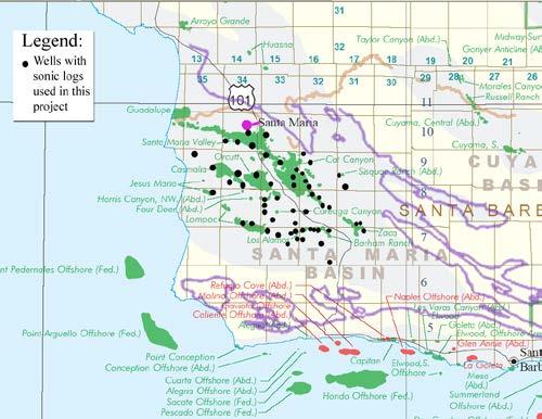
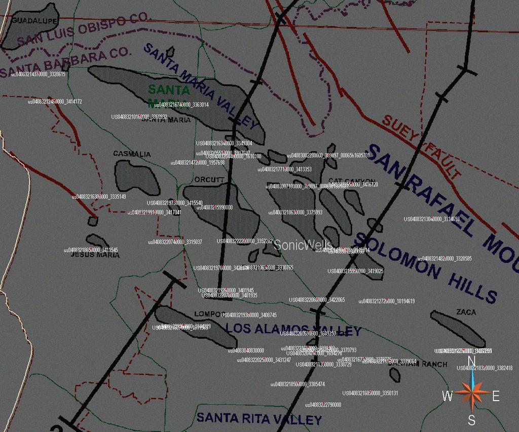
14 Sediment Velocity Structure - Industry sonic logs Süss & Shaw (2003)

15 Industry velocity data

16 Industry velocity data 14,000 log samples 72,000 stacking samples


17 Velocity measures at different scales Residual: vp of log Yellow: model vp minus vp in model Blue: well vp Dark blue: log vp (0.5 ft resolution)
. Salton Trough Defines Vp, Vs, and density to depth of Moho.")
18 Basin structures embedded in regional tomographic model Ventura basin LA basin CVM-H Basin velocities used as input for P and S wave traveltime tomography model (after Hauksson, 2000). Salton Trough Defines Vp, Vs, and density to depth of Moho. Vp (m/s)
.")
19 Moho and upper mantle models CVM-H Moho is defined using receiver functions, reflection/refraction surveys, and seismologic and potential field studies. Upper mantle velocity structure is defined using teleseismic surface wave models (T. Tanimoto).


20 Adjoint, spectral element method enhancement of CVM-H Misfit reduction Snapshot of a wavefield simulation generated by SPECFEM3D using mesh ECHR with model CVMH6.3. The red regions denote amplification of wavefield due to sedimentary basins. Various meshes have 5 million to 1 billion elements (Tape et al.)


21 CVM-H 6.3 and subsequent versions include 3D adjoint waveform tomography updates Full inversion uses more than 200 events, requiring 6800 wavefield simulations, implemented in 16 tomographic iterations. Tape et al., (2009) 6 30 s period
 and synthetics (red traces) for station RUS 50s recent SCEC validations Average goodness-of-fit (perfect fit = 100) at 0.1-0.5 Hz for synthetics relative to data. K.")
22 Evaluating the Community Models Evaluation of models is moving to higher frequency and precision representing early SCEC validations Comparison of recorded data (black traces) and synthetics (red traces) for station RUS 50s recent SCEC validations Average goodness-of-fit (perfect fit = 100) at Hz for synthetics relative to data. K. Olsen

23 USR in DCPP study area Vp in Santa Maria and Ventura basins (CVM-H 11.9): 0m depth

24 USR in DCPP study area Vp in onshore and offshore Santa Maria basin (CVM-H 11.9): 300m depth

25 USR in DCPP study area Vp in onshore and offshore Santa Maria basin (CVM-H 11.9): 1000m depth
26 Potential uses of USR/CVM s in DCPP seismic hazard analysis Precise earthquake relocations Seismic reflection data processing Provides regional context for integration of local studies Model and supporting data can be used in various aspects of deterministic hazards assessment, including strong ground motion calculations. Other potential applications
27 Thank you for your attention

28 Nazareth & Hauksson (2004) use the depth where 99.9% of the total moment in a vertical column was released Steps: Seismogenic thickness surface Selection of events Gridding and computation Filtering of low quality cells Smooth interpolation

29 Community Fault Model (CFM) CFM includes 3D representations of major fault in the DCPP study area.
 0 3 6")
30 Depth slices through high-res model Süss & Shaw (2003) km/s

31 Lithologic control on velocity Vp low in shales Vp high in sands


32 Depositional systems Basinfloor fan deposits resolved in velocity model of the LA basin upper fan shelf slope lower fan submarine high Veloci ty slice at 3600m km/s


33 USR in DCPP study area DCPP DCPP SONGS Onshore Santa Maria basin Onshore Santa Maria basin Vp in onshore and offshore Santa Maria basin (CVM-H 11.9).


34 USR in SONGS study area 0m depth 500m depth 1000m depth Vp in onshore and offshore Santa Maria basin (CVM-H 11.9)
35
Imaging sharp lateral velocity gradients using scattered waves on dense arrays: faults and basin edges
 2017 SCEC Proposal Report #17133 Imaging sharp lateral velocity gradients using scattered waves on dense arrays: faults and basin edges Principal Investigator Zhongwen Zhan Seismological Laboratory, California
SONGS SSC. Tom Freeman GeoPentech PRELIMINARY RESULTS
 SONGS SSC Tom Freeman GeoPentech PRELIMINARY RESULTS Focused Questions Summarize the tectonic setting What is the seismogenic thickness? Are you including deep ruptures in the upper mantle (~30 km)? Do
John Shaw CRUSTAL DEFORMATION MODEL: OBLIQUE CONVERGENCE IN THE INNER CALIFORNIA BORDERLANDS ACCOMMODATED BY ACTIVE STRIKE-SLIP AND REVERSE FAULTS
 CRUSTAL DEFORMATION MODEL: OBLIQUE CONVERGENCE IN THE INNER CALIFORNIA BORDERLANDS ACCOMMODATED BY ACTIVE STRIKE-SLIP AND REVERSE FAULTS August 2013 SONGS SSC SSHAC Workshop # 2 (August 12-14, 2013) Crustal
involved in multiple state-wide re-evaluations of seismic risk by the State of California.
 Resume Andreas Plesch CONTACT INFORMATION Andreas Plesch, 39 Barbara Rd., Waltham, MA 02453 Tel. +1-617-496-9746 (office), Fax. +1-617-495-7660 (office) email: andreas_plesch@gmail.com SUMMARY Ph.D. educated
Diablo Canyon SSHAC Level 3 Study
 1 Diablo Canyon SSHAC Level 3 Study Workshop 1 Summary of SSC Hazard Significant Issues and Data Needed William Lettis November 29 to December 1, 2011 PG&E DCPP SSHAC Study 2 Hosgri Hosgri Location Hosgri
Overview of Seismic Source Characterization for the Diablo Canyon Power Plant
 Overview of Seismic Source Characterization for the Diablo Canyon Power Plant Steve Thompson (LCI and SSC TI Team), for SWUS GMC Workshop 1, March 19, 2013 Questions from TI Team Summarize tectonic setting.
8.0 SUMMARY AND CONCLUSIONS
 8.0 SUMMARY AND CONCLUSIONS In November 2008, Pacific Gas and Electric (PG&E) informed the U.S. Nuclear Regulatory Commission (NRC) that preliminary results from the Diablo Canyon Power Plant (DCPP) Long
DCPP Seismic FAQ s Geosciences Department 08/04/2011 GM1) What magnitude earthquake is DCPP designed for?
 What magnitude earthquake is DCPP designed for?") GM1) What magnitude earthquake is DCPP designed for? The new design ground motions for DCPP were developed after the discovery of the Hosgri fault. In 1977, the largest magnitude of the Hosgri fault was
GM1) What magnitude earthquake is DCPP designed for? The new design ground motions for DCPP were developed after the discovery of the Hosgri fault. In 1977, the largest magnitude of the Hosgri fault was
Kinematics of the Southern California Fault System Constrained by GPS Measurements
 Title Page Kinematics of the Southern California Fault System Constrained by GPS Measurements Brendan Meade and Bradford Hager Three basic questions Large historical earthquakes One basic question How
John Baldwin and Brian Gray Lettis Consultants International, Inc. Alexis Lavine AMEC Josh Goodman and Janet Sowers Fugro Consultants, Inc.
 John Baldwin and Brian Gray Lettis Consultants International, Inc. Alexis Lavine AMEC Josh Goodman and Janet Sowers Fugro Consultants, Inc. December 1, 2011 Pacific Gas & Electric SSHAC Workshop 1 San
SCEC INCITE OLCF PROJECT PROGRESS REPORT,
 SCEC INCITE OLCF PROJECT PROGRESS REPORT, 2015 Title: PI and Co-PI(s): Thomas H. Jordan, Jacobo Bielak, Kim Olsen, Yifeng Cui, Po Chen, Ricardo Taborda, Philip Maechling Applying Institution/Organization:
San Andreas and Other Fault Sources; Background Source
 1 San Andreas and Other Fault Sources; Background Source SSC TI Team Evaluation Steve Thompson Diablo Canyon SSHAC Level 3 PSHA Workshop #3 Feedback to Technical Integration Team on Preliminary Models
BEM Model of slip on the Channel Islands Thrust, CA
 BEM Model of slip on the Channel Islands Thrust, CA Credit Where Credit is Due: Michele Cooke Michele Cooke UMass Amherst Has been training students/postdocs to work with and remesh the CFM since at least
Arthur Frankel, William Stephenson, David Carver, Jack Odum, Robert Williams, and Susan Rhea U.S. Geological Survey
 Probabilistic Seismic Hazard Maps for Seattle: 3D Sedimentary Basin Effects, Nonlinear Site Response, and Uncertainties from Random Velocity Variations Arthur Frankel, William Stephenson, David Carver,
CHAPTER 1 BASIC SEISMOLOGY AND EARTHQUAKE TERMINOLGY. Earth Formation Plate Tectonics Sources of Earthquakes...
 CHAPTER 1 BASIC SEISMOLOGY AND EARTHQUAKE TERMINOLGY Earth Formation... 1-2 Plate Tectonics... 1-2 Sources of Earthquakes... 1-3 Earth Faults... 1-4 Fault Creep... 1-5 California Faults... 1-6 Earthquake
The Seismogenic Thickness of the Southern California Crust
 Bulletin of the Seismological Society of America, Vol. 94, No. 3, pp. 940 960, June 2004 The Seismogenic Thickness of the Southern California Crust by Julie J. Nazareth and Egill Hauksson Abstract The
ACCOUNTING FOR SITE EFFECTS IN PROBABILISTIC SEISMIC HAZARD ANALYSIS: OVERVIEW OF THE SCEC PHASE III REPORT
 ACCOUNTING FOR SITE EFFECTS IN PROBABILISTIC SEISMIC HAZARD ANALYSIS: OVERVIEW OF THE SCEC PHASE III REPORT Edward H FIELD 1 And SCEC PHASE III WORKING GROUP 2 SUMMARY Probabilistic seismic hazard analysis
Regional deformation and kinematics from GPS data
 Regional deformation and kinematics from GPS data Jessica Murray, Jerry Svarc, Elizabeth Hearn, and Wayne Thatcher U. S. Geological Survey Acknowledgements: Rob McCaffrey, Portland State University UCERF3
Eleventh U.S. National Conference on Earthquake Engineering Integrating Science, Engineering & Policy June 25-29, 2018 Los Angeles, California
 Eleventh U.S. National Conference on Earthquake Engineering Integrating Science, Engineering & Policy June 25-29, 2018 Los Angeles, California Site-Specific MCE R Response Spectra for Los Angeles Region
SCEC Simulation Data Access
 SCEC Simulation Data Access 16 February 2018 Philip Maechling (maechlin@usc.edu) Fabio Silva, Scott Callaghan, Christine Goulet, Silvia Mazzoni, John Vidale, et al. SCEC Data Management Approach SCEC Open
Central Coast Seismicity Locations. Jeanne Hardebeck US Geological Survey Menlo Park, CA
 Central Coast Seismicity Locations Jeanne Hardebeck US Geological Survey Menlo Park, CA 11/29/2011 Seismic Network Issues for Earthquake Location: - Many stations are single-component, difficult to identify
EVALUATION OF TSUNAMI RISK FOR COASTAL SOUTHERN CALIFORNIA CITIES. Appendix A - Figures
 EVALUATION OF TSUNAMI RISK FOR COASTAL SOUTHERN CALIFORNIA CITIES Appendix A - Figures Figure 1.Map showing major faults of the southern California region. Northwest-trending faults are rightslip in character.
Overview of the Seismic Source Characterization for the Palo Verde Nuclear Generating Station
 Overview of the Seismic Source Characterization for the Palo Verde Nuclear Generating Station Scott Lindvall SSC TI Team Lead Palo Verde SSC SSHAC Level 3 Project Tuesday, March 19, 2013 1 Questions from
Lab 9: Satellite Geodesy (35 points)
") Lab 9: Satellite Geodesy (35 points) Here you will work with GPS Time Series data to explore plate motion and deformation in California. This lab modifies an exercise found here: http://www.unavco.org:8080/cws/pbonucleus/draftresources/sanandreas/
Lab 9: Satellite Geodesy (35 points) Here you will work with GPS Time Series data to explore plate motion and deformation in California. This lab modifies an exercise found here: http://www.unavco.org:8080/cws/pbonucleus/draftresources/sanandreas/
Simulation-based Seismic Hazard Analysis Using CyberShake
 Simulation-based Seismic Hazard Analysis Using CyberShake SCEC CyberShake Collaboration: Robert Graves, Scott Callaghan, Feng Wang, Thomas H. Jordan, Philip Maechling, Kim Olsen, Kevin Milner, En-Jui Lee,
Splay Fault Considerations
 Splay Fault Considerations Katie Wooddell 24 October 2013 SPLAY FAULT SCENARIOS: THIN CASE: (W=15 km) 9 Scenarios 32 Realizations per Scenario 3 Methods 87 Stations 75,168 Seismograms THICK CASE: (W=22
Geophysical Journal International
 Geophysical Journal International Geophys. J. Int. (2010) 180, 433 462 doi: 10.1111/j.1365-246X.2009.04429.x Seismic tomography of the southern California crust based on spectral-element and adjoint methods
Effects of 3D basin structure on long-period ground motions in SW British Columbia, Canada, for large scenario earthquakes
 Effects of 3D basin structure on long-period ground motions in SW British Columbia, Canada, for large scenario earthquakes S. Molnar University of British Columbia, Vancouver, BC, Canada J.F. Cassidy &
Fault Models SSC TI Team Evaluation Hans AbramsonWard
 1 Fault Models SSC TI Team Evaluation Hans AbramsonWard PG&E DCPP SSHAC Study 2 Outline Constraints on location of active faults: Uplift of ranges Quaternary fault map Constraints on Depth of seismogenic
Short Note Source Mechanism and Rupture Directivity of the 18 May 2009 M W 4.6 Inglewood, California, Earthquake
 Bulletin of the Seismological Society of America, Vol. 100, No. 6, pp. 3269 3277, December 2010, doi: 10.1785/0120100087 Short Note Source Mechanism and Rupture Directivity of the 18 May 2009 M W 4.6 Inglewood,
Imaging Moho topography beneath the Alps by multdisciplinary seismic tomography
 Imaging Moho topography beneath the Alps by multdisciplinary seismic tomography Edi Kissling ETH Zürich SPP short course February 1+2, 218, Berlin, Germany Alpine Moho map from CSS Moho uncertainty derived
We A10 12 Common Reflection Angle Migration Revealing the Complex Deformation Structure beneath Forearc Basin in the Nankai Trough
 We A10 12 Common Reflection Angle Migration Revealing the Complex Deformation Structure beneath Forearc Basin in the Nankai Trough K. Shiraishi* (JAMSTEC), M. Robb (Emerson Paradigm), K. Hosgood (Emerson
Wave-equation-based travel-time seismic tomography Part 2: Application to the 1992 Landers earthquake (M w 7.3) area
 area") doi:10.5194/se-5-1169-2014 Author(s) 2014. CC Attribution 3.0 License. Wave-equation-based travel-time seismic tomography Part 2: Application to the 1992 Landers earthquake (M w 7.3) area P. Tong 1, D.
doi:10.5194/se-5-1169-2014 Author(s) 2014. CC Attribution 3.0 License. Wave-equation-based travel-time seismic tomography Part 2: Application to the 1992 Landers earthquake (M w 7.3) area P. Tong 1, D.
Elastic full waveform inversion for near surface imaging in CMP domain Zhiyang Liu*, Jie Zhang, University of Science and Technology of China (USTC)
") Elastic full waveform inversion for near surface imaging in CMP domain Zhiyang Liu*, Jie Zhang, University of Science and Technology of China (USTC) Summary We develop an elastic full waveform inversion
Elastic full waveform inversion for near surface imaging in CMP domain Zhiyang Liu*, Jie Zhang, University of Science and Technology of China (USTC) Summary We develop an elastic full waveform inversion
Appendix O: Gridded Seismicity Sources
 Appendix O: Gridded Seismicity Sources Peter M. Powers U.S. Geological Survey Introduction The Uniform California Earthquake Rupture Forecast, Version 3 (UCERF3) is a forecast of earthquakes that fall
High Resolution Imaging of Fault Zone Properties
 Annual Report on 1998-99 Studies, Southern California Earthquake Center High Resolution Imaging of Fault Zone Properties Yehuda Ben-Zion Department of Earth Sciences, University of Southern California
THREE-DIMENSIONAL FINITE DIFFERENCE SIMULATION OF LONG-PERIOD GROUND MOTION IN THE KANTO PLAIN, JAPAN
 THREE-DIMENSIONAL FINITE DIFFERENCE SIMULATION OF LONG-PERIOD GROUND MOTION IN THE KANTO PLAIN, JAPAN Nobuyuki YAMADA 1 And Hiroaki YAMANAKA 2 SUMMARY This study tried to simulate the long-period earthquake
Effects of Surface Geology on Seismic Motion
 4 th IASPEI / IAEE International Symposium: Effects of Surface Geology on Seismic Motion August 23 26, 2011 University of California Santa Barbara LONG-PERIOD (3 TO 10 S) GROUND MOTIONS IN AND AROUND THE
2014 SCEC Annual Meeting!
 2014 SCEC Annual Meeting! Palm Springs, California! 7-10 September 2014! Welcome Back to Palm Springs! AVAILABLE FOR DOWNLOAD http://www.scec.org/meetings/ 2014am/SCEC2014Program.pdf Goals of the Annual
Basin & Range / Mojave Desert
 Basin & Range / Mojave Desert Basin & Range vs. Great Basin 1 2/20/2016 An overview of the last horst Basin and Range / Mojave Desert Summary: Granitic, volcanic, marine sedimentary, non marine sedimentary,
DATA ANALYSIS AND INTERPRETATION
 III. DATA ANALYSIS AND INTERPRETATION 3.1. Rift Geometry Identification Based on recent analysis of modern and ancient rifts, many previous workers concluded that the basic structural unit of continental
A three-dimensional crustal seismic velocity model for southern California from a composite event method
 JOURNAL OF GEOPHYSICAL RESEARCH, VOL. 112,, doi:10.1029/2007jb004977, 2007 A three-dimensional crustal seismic velocity model for southern California from a composite event method Guoqing Lin, 1,2 Peter
Some aspects of seismic tomography
 Some aspects of seismic tomography Peter Shearer IGPP/SIO/U.C. San Diego September 7, 2009 Earthquake Research Institute Part 1: Global Tomography P velocity perturbations 200 km 1000 km 2700 km MIT 2006
Scientific Research on the Cascadia Subduction Zone that Will Help Improve Seismic Hazard Maps, Building Codes, and Other Risk-Mitigation Measures
 Scientific Research on the Cascadia Subduction Zone that Will Help Improve Seismic Hazard Maps, Building Codes, and Other Risk-Mitigation Measures Art Frankel U.S. Geological Survey Seattle, WA GeoPrisms-Earthscope
VALIDATION AGAINST NGA EMPIRICAL MODEL OF SIMULATED MOTIONS FOR M7.8 RUPTURE OF SAN ANDREAS FAULT
 VALIDATION AGAINST NGA EMPIRICAL MODEL OF SIMULATED MOTIONS FOR M7.8 RUPTURE OF SAN ANDREAS FAULT L.M. Star 1, J. P. Stewart 1, R.W. Graves 2 and K.W. Hudnut 3 1 Department of Civil and Environmental Engineering,
Marine Science and Oceanography
 Marine Science and Oceanography Marine geology- study of the ocean floor Physical oceanography- study of waves, currents, and tides Marine biology study of nature and distribution of marine organisms Chemical
Earthquake stress drop estimates: What are they telling us?
 Earthquake stress drop estimates: What are they telling us? Peter Shearer IGPP/SIO/U.C. San Diego October 27, 2014 SCEC Community Stress Model Workshop Lots of data for big earthquakes (rupture dimensions,
Scenario Earthquake Shaking Maps in Japan
 1 Scenario Earthquake Shaking Maps in Japan Nobuyuki Morikawa National Research Institute for Earth Science and Disaster Prevention (NIED), JAPAN Scenario Earthquake Shaking Maps (SESMs) The shaking maps
Offshore Evidence for Uplift Rate Boundaries. Hans AbramsonWard Diablo Canyon SSHAC SSC Workshop 2 November 7, 2012
 Offshore Evidence for Uplift Rate Boundaries Hans AbramsonWard Diablo Canyon SSHAC SSC Workshop 2 November 7, 2012 Questions asked by the TI team Discuss your ability to distinguish and correlate offshore
Earthquake Stress Drops in Southern California
 Earthquake Stress Drops in Southern California Peter Shearer IGPP/SIO/U.C. San Diego September 11, 2009 Earthquake Research Institute Lots of data for big earthquakes (rupture dimensions, slip history,
overlie the seismogenic zone offshore Costa Rica, making the margin particularly well suited for combined land and ocean geophysical studies (Figure
 Chapter 1 Introduction Historically, highly destructive large magnitude (M w >7.0) underthrusting earthquakes nucleate along the shallow segment of subduction zone megathrust fault, and this region of
2008 Monitoring Research Review: Ground-Based Nuclear Explosion Monitoring Technologies
 STRUCTURE OF THE KOREAN PENINSULA FROM WAVEFORM TRAVEL-TIME ANALYSIS Roland Gritto 1, Jacob E. Siegel 1, and Winston W. Chan 2 Array Information Technology 1 and Harris Corporation 2 Sponsored by Air Force
Imaging complex structure with crosswell seismic in Jianghan oil field
 INTERPRETER S CORNER Coordinated by Rebecca B. Latimer Imaging complex structure with crosswell seismic in Jianghan oil field QICHENG DONG and BRUCE MARION, Z-Seis, Houston, Texas, U.S. JEFF MEYER, Fusion
2016 SCEC ANNUAL TECHNICAL REPORT - SCEC
 1 2016 SCEC ANNUAL TECHNICAL REPORT - SCEC Award 16065 Continuing to Evaluate 3D Fault Geometry in Special Fault Study Areas and to Update & Improve the SCEC Community Fault Model Craig Nicholson Marine
Tim Dawson (California Geological Survey) Ray Weldon (University of Oregon)
 Ray Weldon (University of Oregon)") UCERF3: w Fault Models and Geologic Slip Rate Tim Dawson (California Geological Survey) Ray Weldon (University of Oregon) Workshop on Use of UCERF3 in the USGS National Seismic Hazard Map October 17-18
UCERF3: w Fault Models and Geologic Slip Rate Tim Dawson (California Geological Survey) Ray Weldon (University of Oregon) Workshop on Use of UCERF3 in the USGS National Seismic Hazard Map October 17-18
High-Frequency Ground Motion Simulation Using a Source- and Site-Specific Empirical Green s Function Approach
 High-Frequency Ground Motion Simulation Using a Source- and Site-Specific Empirical Green s Function Approach R. Mourhatch & S. Krishnan California Institute of Technology, Pasadena, CA, USA SUMMARY: A
3D VISCO-ELASTIC WAVE PROPAGATION IN THE BORREGO VALLEY, CALIFORNIA
 3D VISCO-ELASTIC WAVE PROPAGATION IN THE BORREGO VALLEY, CALIFORNIA Kim B OLSEN 1, Robert L NIGBOR 2 And Takaaki KONNO 3 SUMMARY We have simulated 2-Hz wave propagation in a three-dimensional model of
Jack Loveless Department of Geosciences Smith College
 Geodetic constraints on fault interactions and stressing rates in southern California Jack Loveless Department of Geosciences Smith College jloveless@smith.edu Brendan Meade Department of Earth & Planetary
Seismic Issues for California's Nuclear Power Plants. Norman Abrahamson University of California, Berkeley
 Seismic Issues for California's Nuclear Power Plants Norman Abrahamson University of California, Berkeley From UCERF 2 Seismic Setting for California s Nuclear Power Plants Major Offshore Strike-Slip Faults
Nancy Natek The University of New Mexico
 Constraints on the SCEC 3D Velocity Model from Gravity Data: Two-Dimensional Gravity Modeling of the Central and Eastern Transverse Ranges in the Los Angeles Region Nancy Natek The University of New Mexico
The Southern California Earthquake Center, Phase 4 (SCEC4): Tracking Earthquake Cascades
: Tracking Earthquake Cascades") The Southern California Earthquake Center, Phase 4 (SCEC4): Tracking Earthquake Cascades Proposal Submitted to National Science Foundation and U.S. Geological Survey March 2010 Project Summary...i I. Introduction...1
The Southern California Earthquake Center, Phase 4 (SCEC4): Tracking Earthquake Cascades Proposal Submitted to National Science Foundation and U.S. Geological Survey March 2010 Project Summary...i I. Introduction...1
9th Workshop on Three-Dimensional Modelling of Seismic Waves Generation, Propagation and their Inversion
 1965-36 9th Workshop on Three-Dimensional Modelling of Seismic Waves Generation, Propagation and their Inversion 22 September - 4 October, 2008 Tomography and Active Tectonics in Kanto, Japan Francis T.
Japan Seismic Hazard Information Station
 Japan Seismic Hazard Information Station (J-SHIS) Hiroyuki Fujiwara National Research Institute for Earth Science and Disaster Prevention (NIED) Background of the Project Headquarters for Earthquake Research
SIMULATING STRONG GROUND MOTION FROM COMPLEX SOURCES BY RECIPROCAL GREEN FUNCTIONS ABSTRACT
 SIMULATING STRONG GROUND MOTION FROM COMPLEX SOURCES BY RECIPROCAL GREEN FUNCTIONS L. EISNER*, R.W. CLAYTON Seismological Laboratory, 1200 California Blvd. 252-21, California Institute of Technology, Pasadena,
NEODETERMINISTIC SEISMIC HAZARD ASSESSMENT. Seismic hazard in Asia Trieste 4-8 December 2006
 H4.SMR/1882-2 Seismic Hazard in Asia 4-8 December 2006 Neodeterministic Hazard Assessment G.F. Panza 1, 2 1 Department of Earth Sciences University of Trieste 2 ICTP SAND Group, Trieste NEODETERMINISTIC
Strain Green s Tensors, Reciprocity, and Their Applications to Seismic Source and Structure Studies
 Bulletin of the Seismological Society of America, Vol. 96, No. 5, pp. 1753 1763, October 2006, doi: 10.1785/0120050253 Strain Green s Tensors, Reciprocity, and Their Applications to Seismic Source and
Ocean Basins, Bathymetry and Sea Levels
 Ocean Basins, Bathymetry and Sea Levels Chapter 4 Please read chapter 5: sediments for next class and start chapter 6 on seawater for Thursday Basic concepts in Chapter 4 Bathymetry the measurement of
Tu N Fault Shadow Removal over Timor Trough Using Broadband Seismic, FWI and Fault Constrained Tomography
 Tu N118 05 Fault Shadow Removal over Timor Trough Using Broadband Seismic, FWI and Fault Constrained Tomography Y. Guo* (CGG), M. Fujimoto (INPEX), S. Wu (CGG) & Y. Sasaki (INPEX) SUMMARY Thrust-complex
RECORD OF REVISIONS. Page 2 of 17 GEO. DCPP.TR.14.06, Rev. 0
 Page 2 of 17 RECORD OF REVISIONS Rev. No. Reason for Revision Revision Date 0 Initial Report - this work is being tracked under Notification SAPN 50638425-1 8/6/2014 Page 3 of 17 TABLE OF CONTENTS Page
60% water. Big Bang: 14,000 millions years ago The Earth originated about 4,500 millions years ago its orbit allows water to exist in a liquid state!
 Ch2. The Sea Floor #1 Why geology of the oceans? Marine habitats are directly shaped by geological processes The form of the coastlines The depth of the water Type of bottom (muddy, sandy, rocky) #2 Geological
Topic 12: Dynamic Earth Pracatice
 Name: Topic 12: Dynamic Earth Pracatice 1. Earth s outer core is best inferred to be A) liquid, with an average density of approximately 4 g/cm 3 B) liquid, with an average density of approximately 11
Model Building Complexity in the Presence of a Rugose Water Bottom Gippsland Basin Australia
 Model Building Complexity in the Presence of a Rugose Water Bottom Gippsland Basin Australia Paul Bouloudas, Apache Energy, Juergen Fruehn, ION GX Technology Introduction Situated offshore south-eastern
The Earth s Structure from Travel Times
 from Travel Times Spherically symmetric structure: PREM - Crustal Structure - Upper Mantle structure Phase transitions Anisotropy - Lower Mantle Structure D D - Structure of of the Outer and Inner Core
Geo736: Seismicity and California s Active Faults Introduction
 Geo736: Seismicity and California s Active Faults Course Notes: S. G. Wesnousky Spring 2018 Introduction California sits on the boundary of the Pacific - North American plate boundary (Figure 1). Relative
Regional Geodesy. Shimon Wdowinski. MARGINS-RCL Workshop Lithospheric Rupture in the Gulf of California Salton Trough Region. University of Miami
 MARGINS-RCL Workshop Lithospheric Rupture in the Gulf of California Salton Trough Region Regional Geodesy Shimon Wdowinski University of Miami Rowena Lohman, Kim Outerbridge, Tom Rockwell, and Gina Schmalze
Acoustic wave-equation-based earthquake location
 submitted to Geophys. J. Int. Acoustic wave-equation-based earthquake location Ping Tong 1, Dinghui Yang 2, Qinya Liu 3, Xu Yang 4 and Jerry Harris 1 1 Department of Geophysics, Stanford University, California,
Refraction Microtremor for Shallow Shear Velocity in Urban Basins
 Refraction Microtremor for Shallow Shear Velocity in Urban Basins John Louie, Nevada Seismological Lab UNR students: J. B. Scott, T. Rasmussen, W. Thelen, M. Clark Collaborators: S. Pullammanappallil &
2008 Monitoring Research Review: Ground-Based Nuclear Explosion Monitoring Technologies ADVANCED WAVEFORM SIMULATION FOR SEISMIC MONITORING
 ADVANCED WAVEFORM SIMULATION FOR SEISMIC MONITORING Donald V. Helmberger 1, Arthur J. Rodgers 2, Sidao Ni 1,3, Shengji Wei 1, and Jeroen Tromp 1 California Institute of Technology 1, Lawrence Livermore
Oceanic Detachment Faults Generate Compression in Extension
 GSA Data Repository 2017309 Oceanic Detachment Faults Generate Compression in Extension R. Parnell-Turner 1, R. A. Sohn 1, C. Peirce 2, T. J. Reston 3, C. J. MacLeod 4, R. C. Searle 2 and N. M. Simão 2.
27th Seismic Research Review: Ground-Based Nuclear Explosion Monitoring Technologies
 SEISMIC SOURCE AND PATH CALIBRATION IN THE KOREAN PENINSULA, YELLOW SEA, AND NORTHEAST CHINA Robert B. Herrmann 1, Young-Soo Jeon 1, William R. Walter 2, and Michael E. Pasyanos 2 Saint Louis University
Chapter Two. Figure 02_02. Geography of the Ocean Basins. The Sea Floor
 Chapter Two The Sea Floor Geography of the Ocean Basins Figure 02_02 The world ocean is the predominant feature on the Earth in total area. In the Northern Hemisphere, 61% of the total area is ocean. In
Comparison of Strain Rate Maps
 Comparison of Strain Rate Maps David T. Sandwell UNAVCO March 8, 2010 why strain rate matters comparison of 10 strain rate models new data required interseismic model velocity v(x) = V π tan 1 x D strain
Dynamic Crust Practice
 1. Base your answer to the following question on the cross section below and on your knowledge of Earth science. The cross section represents the distance and age of ocean-floor bedrock found on both sides
Global Tectonics. Kearey, Philip. Table of Contents ISBN-13: Historical perspective. 2. The interior of the Earth.
 Global Tectonics Kearey, Philip ISBN-13: 9781405107778 Table of Contents Preface. Acknowledgments. 1. Historical perspective. 1.1 Continental drift. 1.2 Sea floor spreading and the birth of plate tectonics.
VALIDATION OF A 3D VELOCITY MODEL OF THE PUGET SOUND REGION BASED ON MODELING LONG PERIOD GROUND MOTION DATA
 13 th World Conference on Earthquake Engineering Vancouver, B.C., Canada August 1-6, 2004 Paper No. 2738 VALIDATION OF A 3D VELOCITY MODEL OF THE PUGET SOUND REGION BASED ON MODELING LONG PERIOD GROUND
GPS Monitoring of the San Andreas Fault and Modeling of Slip Rate on the Mojave Section of the San Andreas Fault
 GPS Monitoring 1 GPS Monitoring of the San Andreas Fault and Modeling of Slip Rate on the Mojave Section of the San Andreas Fault By Nayeli Jimenez and Mischel Bartie PRISM Research Program Coordinator:
Seismogram Interpretation. Seismogram Interpretation
 Travel times in the Earth Ray paths, phases and their name Wavefields in the Earth: SH waves, P-SV waves Seismic Tomography Receiver Functions Seismogram Example Long-period transverse displacement for
The Cascading Hazards from Cascadia s Earthquakes
 Tsunamis The Cascading Hazards from Cascadia s Earthquakes Earthquakes (Nisqually earthquake, Seattle, WA) Volcanoes (Mt St Helens eruption, WA) Joan Gomberg gomberg@usgs.gov Landslides (Oso landslide,
24. Ocean Basins p
 24. Ocean Basins p. 350-372 Background The majority of the planet is covered by ocean- about %. So the majority of the Earth s crust is. This crust is hidden from view beneath the water so it is not as
Tomography of the 2011 Iwaki earthquake (M 7.0) and Fukushima
 and Fukushima") 1 2 3 Auxiliary materials for Tomography of the 2011 Iwaki earthquake (M 7.0) and Fukushima nuclear power plant area 4 5 6 7 8 9 Ping Tong 1,2, Dapeng Zhao 1 and Dinghui Yang 2 [1] {Department of Geophysics,
1 2 3 Auxiliary materials for Tomography of the 2011 Iwaki earthquake (M 7.0) and Fukushima nuclear power plant area 4 5 6 7 8 9 Ping Tong 1,2, Dapeng Zhao 1 and Dinghui Yang 2 [1] {Department of Geophysics,
Tomographic imaging of P wave velocity structure beneath the region around Beijing
 403 Doi: 10.1007/s11589-009-0403-9 Tomographic imaging of P wave velocity structure beneath the region around Beijing Zhifeng Ding Xiaofeng Zhou Yan Wu Guiyin Li and Hong Zhang Institute of Geophysics,
RR#8 - Free Response
 Base your answers to questions 1 through 4 on the passage and the map below and on your knowledge of Earth science. The map indicates the epicenter (*) of a major earthquake that occurred at 38 N 142 E.
Why does the Earth have volcanoes? Why is there Earthquakes?
 Why does the Earth have volcanoes? Why is there Earthquakes? Turn to your neighbor and review: How and when did the Earth form? How old are the first traces of life on Earth? Logical? * 1.5Ga (1 st multicellular
Unit Topics. Topic 1: Earth s Interior Topic 2: Continental Drift Topic 3: Crustal Activity Topic 4: Crustal Boundaries Topic 5: Earthquakes
 The Dynamic Earth Unit Topics Topic 1: Earth s Interior Topic 2: Continental Drift Topic 3: Crustal Activity Topic 4: Crustal Boundaries Topic 5: Earthquakes Topic 1: Earth s Interior Essential Question:
Updated Graizer-Kalkan GMPEs (GK13) Southwestern U.S. Ground Motion Characterization SSHAC Level 3 Workshop 2 Berkeley, CA October 23, 2013
 Southwestern U.S. Ground Motion Characterization SSHAC Level 3 Workshop 2 Berkeley, CA October 23, 2013") Updated Graizer-Kalkan GMPEs (GK13) Southwestern U.S. Ground Motion Characterization SSHAC Level 3 Workshop 2 Berkeley, CA October 23, 2013 PGA Model Our model is based on representation of attenuation
Updated Graizer-Kalkan GMPEs (GK13) Southwestern U.S. Ground Motion Characterization SSHAC Level 3 Workshop 2 Berkeley, CA October 23, 2013 PGA Model Our model is based on representation of attenuation
Data Repository: Seismic and Geodetic Evidence For Extensive, Long-Lived Fault Damage Zones
 DR2009082 Data Repository: Seismic and Geodetic Evidence For Extensive, Long-Lived Fault Damage Zones Fault Zone Trapped Wave Data and Methods Fault zone trapped waves observed for 2 shots and 5 local
IV. ENVIRONMENTAL IMPACT ANALYSIS E. GEOLOGY AND SOILS
 IV. ENVIRONMENTAL IMPACT ANALYSIS E. GEOLOGY AND SOILS INTRODUCTION This section evaluates potential impacts related to geology, including seismicity, and soils associated with development of the proposed
OZ SEEBASE TM. Datasets. Digital Elevation Model
 Digital Elevation Model 10 Digital Elevation Models (DEM s) often show the youngest structures, and any active geological structures. They are widely used for neotectonic analysis. The composition of eroding
Sendai Earthquake NE Japan March 11, Some explanatory slides Bob Stern, Dave Scholl, others updated March
 Sendai Earthquake NE Japan March 11, 2011 Some explanatory slides Bob Stern, Dave Scholl, others updated March 14 2011 Earth has 11 large plates and many more smaller ones. Plates are 100-200 km thick
Tracing rays through the Earth
 Tracing rays through the Earth Ray parameter p: source receiv er i 1 V 1 sin i 1 = sin i 2 = = sin i n = const. = p V 1 V 2 V n p is constant for a given ray i 2 i 3 i 4 V 2 V 3 V 4 i critical If V increases