Prepared by: J. C. Grant, December Contributions by: Stephen Roach Alan Smith
|
|
|
- Curtis Barnett
- 6 years ago
- Views:
Transcription
1 GEOPHYSICAL REPORT FOR TRELAWNEY MINING AND EXPLORATION INC. ON THE MISHIBISHU PROJECT MISHIBISHU LAKE AREA SAULT STE. MARIE MINING DIVISION NORTHERN, ONTARIO Prepared by: J. C. Grant, December 2015 : Contributions by: Stephen Roach Alan Smith
2 TABLE OF CONTENTS SUMMARY Page 1 INTRODUCTION 2 PROPERTY LOCATION AND ACCESS 2 CLAIM BLOCK 5 PERSONNEL 5 GROUND PROGRAM 6 MAGNETIC SURVEY IP SURVEY PROPERTY GEOLOGY 9 MAGNETIC SURVEY RESULTS 10 IP SURVEY RESULTS 12 CONCLUSIONS AND RECOMMENDATIONS. 16 CERTIFICATE 18 LIST OF FIGURES: FIGURE 1, LOCATION MAP FIGURE 2, PROPERTY LOCATION MAP FIGURE 3, REGIONAL GEOLOGY MAP FIGURE 4, TRELAWNEY CLAIM BLOCK FIGURE 4a, GEOPHYSICAL GRID MAP APPENDICES: A: SCINTREX ENVI MAG SYSTEM B: G.D.D. IP RECEIVER, G.D.D. 2, 5000 KW TRANSMITTER C: IP RESULTS COMPILATION D: PLAN MAP TOTAL FIELD MAGNETICS, 1:2,500 INDIVIDUAL LINE PSEUDO-SECTIONS OF IP LINES IN COLOR, 1:2,500.
3 SUMMARY The Mishibishu (Mishi) Property is located 50 kilometers west of Wawa and 65 kilometers south of White River, Ontario. Access to the property can be attained by road and helicopter from Wawa, Ontario. The claims of the project are wholly owned by Trelawney Mining and Exploration Inc. (Trelawney) and consist of 208 units in 18 unpatented mining claims covering approximately 3328 hectares (41N14, 42C03, 42C04). Most of the historical exploration occurred in the 1980 s and 1990 s when production proceeded with the Magnacon and Mishi Mine pit, and the discovery of the Eagle River Deposit. Other than Wesdome Gold Mines, Trelawney has been the most active exploration company in the area in recent times, completing extensive prospecting, airborne magnetic / EM surveying, and diamond drilling (53 DDH, 18,844m) from The purpose of the 2015 geophysical program on the Mishi Property was to evaluate and expand an area where historical drilling intersected widespread gold mineralization within the Rook Lake Deformation (RLDZ) in A total of 23.5 km of line-cutting and magnetic survey was completed, and 15 kilometers of pole-dipole IP was also completed, starting in late October and finishing on November 28, The Mishi Property is located in the Mishibishu Greenstone Belt (2670 to 2713 Ma), located in the Wawa Subprovince of the Superior Province. It consists of weakly to strongly metamorphosed metavolcanics and metasediments intruded by a variety of complex intrusives. The metavolcanic supracrustal rocks underlying the property are bimodal and classify as calc-alkaline rhyolite to dacite and magnesium to iron-rich tholeiitic basalt metavolcanics. The bimodal metavolcanics account for 75% of the rocks underlying the property, and consist of massive, pillow, to porphyritic mafic flows and felsic fragmentals. Clastic metasediments account for 20% of the exposed bedrock and generally become more prolific and thicker in the northern part of the property. They consist of interbedded greywacke, and argillaceous/arenaceous metasediments, with thin volcaniclastic inter-formational units within mafic metavolcanics. The remaining 5% part of the property is underlain by chemical metasediments which consist of silicate/oxide facies banded iron formation (BIF) with sulphide-rich exhalative cherty tuff, located in the central part of the property. This marks a general boundary between the felsic and mafic metavolcanics. A series of thin, discontinuous quartz-diorite to diorite/gabbro intrusives are located in the southern part of the property. The monzo-granite and granodiorite intrusives (2673±12) of the Central Pluton, Mishibishu Lake Stock, and Bowman Batholith, and diabase dykes account for the remaining < 1%, cross-cutting and metamorphosing the supracrustal rocks. The rocks underlying the property have undergone regional greenschist metamorphism, with an upper greenschist to mid-amphibolite metamorphism in proximity to the Central Pluton and the Mishibishu Lake Stock. The bedding and foliation of the metasediments and metavolcanics generally trend east-west. Fold axis lineation along the RLDZ indicate a shallow to steep plunge of between 39º to 77º to the east. Although several sulphide showings and zones were located, extensive alteration and deformation has been recognized in all three map areas. The strongly altered and sheared/fractured felsic and mafic metavolcanics of the RLDZ has similar host rock, geochemical, and alteration characteristics to Wesdome Gold Mines Eagle River Mine (961,936 oz Au in 3,295, g/t Au total production) and the Mishi Mine pit (22,713 oz Au in 222, g/t Au total production), respectively. Airborne magnetics indicate variable trending magnetic lows and breaks and are consistent to regional deformation zones and cross-cutting features. The geological environment characterized by rocks underlying the Mishi Property has similarities to the deformation zones hosting Wesdome s producing mines in the Mishibishu Greenstone Belt, and known mesothermal lode gold mineralization in various Ontario mining camps, such as Timmins and Red Lake. Although no significant gold values were returned, the RLDZ on the Mishi Property has been outlined partially over 6 kilometers as part of a 20 kilometer long anastomosing shear zone. It consists of strongly sheared and hydrothermally altered metavolcanics. Historical drill hole M intersected over 80 meters of strong fractured and brecciated felsic/cherty tuff exhalative and strongly sheared chlorite-carbonate altered mafic metavolcanics with continuous anomalous gold values up to 0.28 g/t Au over 56.7 meters. The IP and magnetic survey were successful in outlining four (4) major IP chargeability zones, with two of the chargeability zones associated with a strong, linear magnetic low trending southwest splaying off the main RLDZ. 1
4 INTRODUCTION: The services of Exsics Exploration Limited were commissioned on behalf of Trelawney Mining and Exploration Inc., to complete a total field magnetic survey and an Induced Polarization, (IP), survey over the Mishibishu (Mishi) Property located in the north central section of Mishibishu Lake Area. The Mishibishu Project area is located to the immediate north of the Eagle River Gold Mine and south of the Mishi and Magnacon Gold properties. The purpose of this program was to investigate favorable stratigraphy hosting Au identified in historic diamond drilling. Geological investigations were completed in 2014 by Trelawney Mining and Exploration (wholly-owned subsidiary of IAMGOLD Corp) to follow-up anomalous Au values of 0.28 g/t Au / 56.7m encountered within an 80m interval of strongly fracture and altered felsic and mafic metavolcanics. The 2015 geophysical surveying program was centered on this target. PROPERTY LOCATION AND ACCESS: The Mishi Property is located 50 kilometers west of Wawa and 65 kilometers south of White River, Ontario (Figure 1). It is located in the Sault Ste. Marie Mining Division (NTS 42C/03SW and 41N/14NW). The Mishi Property can be accessed by both road via the Paint Lake Road from the Trans- Canada Highway 17 and by helicopter from Wawa. The Paint Lake Road is approximately 48.8 kilometers northwest of Wawa along Highway 17, with access to the property between 50 KM and 68 KM along the Paint Lake (mine) Road from the Trans-Canada Highway 17. The Paint Lake Road offers direct and easy access to most of the claim group, bisecting the claims in a north-south direction, and links Highway 17 to Wesdome s Eagle River Mine and Mishi Pit, with a security gate at KM 52. The grid is located between KM 57 and 59 on the Paint Lake Mine Road, two kilometers southwest of Mishibishu Lake. The Exsics Exploration crew stayed at Moose Lodge on Highway 17, situated 12 kilometers to the northwest of the Paint Lake Road. They stayed from about October 24, 2015 to November 28,

5 Fig 1 1

6
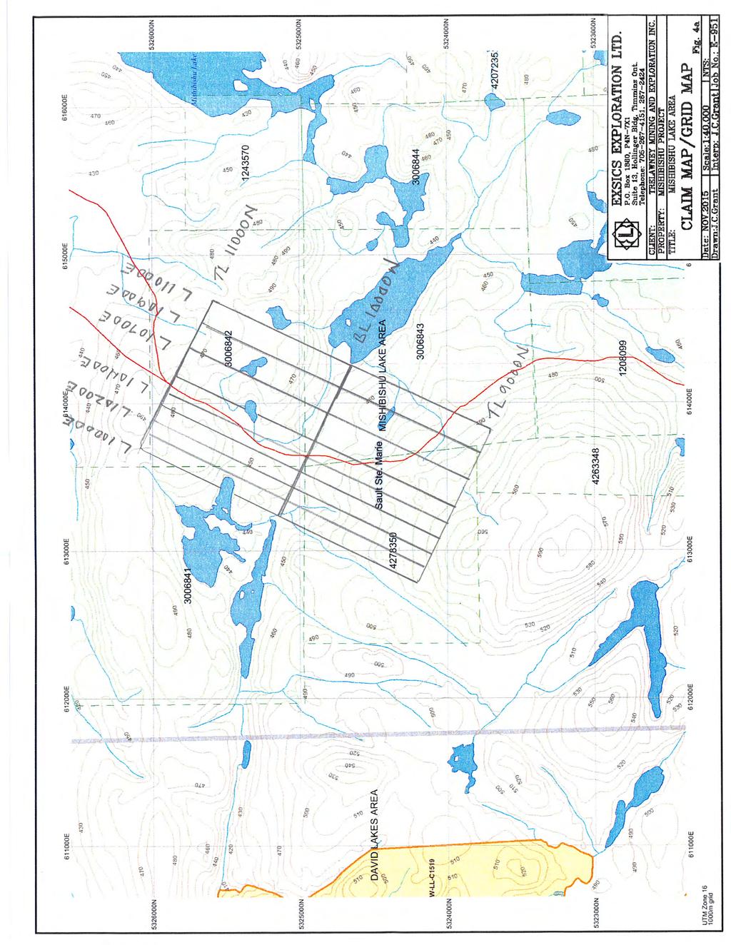
7 CLAIM BLOCK: The Mishi Property consists of 208 units in 18 unpatented mining claims, covering approximately 3328 hectares (Figure 2). The mining claims are wholly owned by Trelawney Mining and Exploration Inc. (3 Mesomikenda Lake Road, Gogama, Ontario P0M 1W0). The claim schedule is summarized in Table 1. Claims which were covered by the line-cutting and geophysical surveys are as follows: Units Units Units Units Table 1 Claim Schedule Mishibishu Lake (G-3772) Trelawney Mining & Exploration Inc. January 26, Mishibishu Lake (G-3772) Trelawney Mining & Exploration Inc. January 26, Mishibishu Lake (G-3772) Trelawney Mining & Exploration Inc. January 26, Mishibishu Lake (G-3772) Trelawney Mining & Exploration Inc. January 26, Point Isacor (G-3778) Trelawney Mining & Exploration Inc. January 26, Mishibishu Lake (G-3772) Trelawney Mining & Exploration Inc. January 26, Mishibishu Lake (G-3772) Trelawney Mining & Exploration Inc. January 26, Mishibishu Lake (G-3772) Trelawney Mining & Exploration Inc. January 26, Mishibishu Lake (G-3772) Trelawney Mining & Exploration Inc. January 26, Mishibishu Lake (G-3772) Trelawney Mining & Exploration Inc. February 7, Mishibishu Lake (G-3772) Trelawney Mining & Exploration Inc. February 7, Mishibishu Lake (G-3772) Trelawney Mining & Exploration Inc. February 7, Mishibishu Lake (G-3772) Trelawney Mining & Exploration Inc. February 22, Mishibishu Lake (G-3772) Trelawney Mining & Exploration Inc. May 10, Mishibishu Lake (G-3772) Trelawney Mining & Exploration Inc. February 22, Mishibishu Lake (G-3772) Trelawney Mining & Exploration Inc. April 22, Mishibishu Lake (G-3772) Trelawney Mining & Exploration Inc. April 22, claims One of the claims was acquired for Trelawney Mining and Exploration by staking ( ) and registered October 29, PERSONNEL: The field crew directly responsible for the collection of all the raw data were as follows. IP and Magnetic Survey Crew: J. Francoeur Timmins, Ontario A. Chamberlain Timmins, Ontario D. Poirier Timmins, Ontario R. Bradshaw Timmins, Ontario 5
8 DJ Gibson Timmins, Ontario D. Belair Timmins, Ontario R. Belair Timmins, Ontario N. Collins Timmins, Ontario C. Glouster Timmins, Ontario The field work was completed under the direct supervision of J. C. Grant of Exsics. The survey team was contracted by Stephen Roach (Trelawney Mining and Exploration Inc.) who supervised the project work. GROUND PROGRAM: The ground program was completed in two phases. The first phase was to establish a detailed metric grid across the claims. This was done by first establishing a base line that was turned off at a point designated by Trelawney. The base line was turned off at this point and cut at 115 degrees for 750 meters to line 11100ME which represented the southeast limit of the grid. The base line was also cut 350 meters at 295 degrees to line 10000ME which represented the northwest limit of the grid. Lines were turned off perpendicular to this base line at 100 meter intervals from line 10000ME to 10500ME and then at 200 meter intervals from 10500ME to 11100ME. All of these cross lines were then cut 1000 meters to the northeast and 1000 meters to the southwest of the base line to two tie lines labelled 11000MN and 9000MN which were cut parallel to the base line. All of the base lines, tie lines and cross lines were chained at 25 meter intervals and all station pickets have been metal tagged. In all a total of 21.3 kilometers of cut lines were completed across the claim block between October 24 th and November 7th Once the cutting was completed the grid was covered by a total field magnetic survey that was done in conjunction with an IP survey. The magnetic survey was completed using the Scintrex Envi mag system. Specifications can be found as Appendix A of this report. The following parameters were kept constant throughout the magnetic survey. Magnetic survey: Line spacing Station spacing Reading intervals Diurnal monitoring Base record intervals Reference field Datum subtracted Unit accuracy 100 and 200 meters 25 meters 12.5 meters base station recorder 30 seconds 56000nT 55500nT +/- 0.1 gamma 6
9 ± » MISHI PIT» MAGNACON MINE Pukaskwa Batholith Paint Lake Mine Road Mishibishu Lake Stock Central Pluton Bowman Lake Pluton » EAGLE RIVER MINE Legend» Mines Roads Watercourse Wetland Waterbody Lithology Unit Proterozoic to Archaean mafic intrusives Felsic to Intermediate Intrusives Mafic intrusives Synvolcanic felsic to intermediate intrusives Clastic metasediments Chemical metasediments Felsic metavolcanics Mafic metavolcanics
10 ± Legend Roads Watercourse Topography Wetland Waterbody Mishibishu Lake Cameron Lake Rook Lake Paint Lake Mine Road
11 The IP survey was completed using the G.D.D. transmitter and receiver units. Specifications for these units can be found as Appendix B of this report. The collected and corrected magnetic data was then plotted onto a base map at a scale of 1:2500 and then contoured at 25 gamma intervals wherever possible. A copy of this color contoured plan map is provided in Appendix D. The following parameters were used for the IP survey: IP Survey: Line spacing Station spacing Reading intervals IP method IP array Delay time Timing Number of electrodes Electrode spacing Parameters measured 100 and 200 meters 25 meters 50 meters Time domain Pole-Dipole 240Ms 80Ms through 20 windows 10 stainless steel 50 meters Chargeability and Apparent Resistivity The data was then plotted on individual line pseudo-sections at a scale of 1:2500 showing the contoured results of the chargeability and resistivity as well as for the calculated metal factors. Copies of these individual color sections are included in Appendix D. The ground geophysical surveys were completed between November 9 th and 30 th, PROPERTY GEOLOGY: The Mishibishu Property and grid area is situated in the Mishibishu Lake Greenstone Belt, an Archean greenstone belt which lies within the Wawa Sub province of the Superior Structural Province. The belt strikes in a rough east west direction, and is approximately 50 km long, and up to 20 km wide. The Mishibishu Lake greenstone belt is bounded to the north, northeast and northwest by the Pukaskwa granitic batholith, and to the south, by the Floating Heart batholith. At least three major granitic batholiths are located within the belt.supracrustal rocks in the belt are similar to other Archean greenstone belts found in northern Ontario. The rocks consist predominately of metavolcanicsand metasedimentary rocks, intruded by felsic and mafic dikes and sills. The regional geology has been well described by Bowen, 1985, and others. Approximately 55 % of the Mishibishu Lake belt is underlain by metavolcanic and metasedimentary rocks, with magnesium and iron tholeiitic volcanics covering approximately 20 % of the area. Felsic to intermediate volcanic rocks occupy approximately 15% of the area and clastic metasediments cover approximately 20% of the area. 9
12 Chemical sediments comprise less than 1%, and occur as sulphide and oxide facies iron formation. These rocks have been intruded by syn-tectonic to post-tectonic intrusive complexes ranging from felsic to intermediate composition.the supracrustal rocks are Precambrian in age, and have been metamorphosed to upper greenschist facies or lower. Diabase dikes intrude all of the above rocks. MAGNETIC SURVEY RESULTS: The magnetic survey was completed on the entire cut grid and was successful in outlining the geological characteristics of the grid. Certainly the most predominant magnetic structure outlined is the significant magnetic low that strikes across the entire grid at an azimuth of 115 and continues off of the grid in both directions. This structure is generally situated between 9650MN and 9700MN and appears to dip near vertical. The structure is quite visible on the grid as it is represented by a well-defined drainage system that generally lies between two well defined rock edges that are about meters in height and represent the north and south limbs of the magnetic low unit. Visual inspection of the rock faces by the survey crew suggest that there is abundant rust stained patches and stringers within the faces and there appears to be mixed quartz rubble along the bottom of these rock ledges. This structure most probably relates to the northwest extension of the Rook Lake Deformation Zone. This deformation Zone may have been faulted slightly to the southwest by a suspected fault that is assumed to strike northeast-southwest across the western tip of the lake that lies just east of the base line and line 11000ME. This fault structure was not outlined by the current ground program as it appears that the fault is off of the grid and to the east of line 11000ME. This deformation zone has cross cut and or offset several of the narrow magnetic highs that strike across the southern and central southern sections of the grid. One such narrow high can be traced from the southern tip of line 10700ME to about 9575MN on line 10400ME where it is cut off by the deformation zone and then possibly continues along line 10400ME to about 9850MN where it seems to come in contact with the geological contact between the Metasedimentary rock unit and the felsic intrusive. This narrow high appears again on line 10200ME at 10500MN and continues north to the northern tip of line 10050ME at 11000MN. This type of narrow magnetic high is indicative of dike like units. Another narrow magnetic high unit strikes from the first narrow high at 10600ME 9200MN and can be followed up to the deformation zone where it appears to be faulted to the north and then continues to the northeast striking across lines 10700ME at 9750MN to at least line 10900ME at MN. This dike like unit may then continue northeast paralleling line 10900ME to its northern tip. 10
13
14 The two narrow magnetic high units that strike parallel to the base line and can be followed from line 10400ME to 10000ME between 9250MN and 9300MN and from line 10900ME to 10000ME at 10150MN ay correlate to the upper and lower contacts of the Metasedimentary unit that lies between the felsic intrusive to the southwest and the felsic intrusive cutting across the central north section of the current grid. The magnetic high activity across the northern section of the grid lines may also correlate to the felsic intrusive that may have been cross cut by the dike like units paralleling lines 10100ME and 10200ME as well as a possible dike like feature paralleling line 10900ME. Spotty magnetic lows along these dike like features may represent dipole effects. IP SURVEY RESULTS: The IP surveys were completed on all of the cross line with the exception of line 10900ME and the northern half of line 10000ME due to a number of small lakes and flooded areas. Each of the grid lines covered by the IP survey will be discussed separately and in detail below along with any and all magnetic correlation. LINE 11100ME: There are at least 4 IP zones that were outlined across this grid line. The first is a moderate to strong zone that was noted on the northern tip of the line that is building as it continues off of the grid to the north. The zone appears to be relatively shallow with a modest shallow resistivity high that lies on the northern flank of a broad resistivity low. The zone correlates to a magnetic high and lies within the metasediments. The second zone is a deep rooted zone between 10275Mn and 10350MN that is associated with a resistivity low unit which may be indicative of the metasediment to felsic contact. The zone is associated with a narrow spot mag high and spot low just to the east of the suspected dike like unit. The zone may continue off of the grid to the southeast. The third zone lies between 9600Mn and 9800MN and it lies on the immediate north limb of the deformation zone. The zone is a moderate to strong broad IP anomaly with a modest resistivity high that lie to the immediate north of a narrow low which most likely represents the deformation zone. The final IP zone lies between 9250Mn and the south end of the line and it represents a moderate to strong zone building at depth with good resistivity high association. This zone lies just to the south of the access road and the power line that follows the road. 12
15 LINE 10700ME: There were 3 to 4 IP zones outlined across this line. The first zone lies between 10700MN and the north end of the line and continues off of the grid to the north. The zone is associated with a deep resistivity high and a spot magnetic high and it appears to lie within the sediments. The second zone lies between 9850MN and that portion of the line that lies under the swollen creek. It is associated with a modest resistivity high and a modest magnetic high. The zone lies on the northern edge of the deformation zone. The third zone lies between 9575MN and 9675MN that correlates to a moderate resistivity high and appears to correlate directly with the Deformation Zone. The zone also appears to be quite deep at its core. The final zone is a modest near surface response situated between 9150MN and 9200MN that correlates to a modest resistivity spot high above a resistivity low. The zone correlates to the eastern edge of one of the dike like units as well as the contact between the sediments and felsic units. LINE 10500ME: There were multiple zones outlined across this line as well. The first zone was noted at the northern tip of the line and it continues off of the grid to the northeast. The zone is a moderate shallow zone with a modest resistivity high association as well as a modest magnetic high association within the sediments. The second zone is a deeper rooted zone situated between 10300Mn and 10400MN that has a modest to weak magnetic high association. The zone appears to lie at the suspected contact between the felsic unit to the south and the sediments to the north. The next zone is a broad IP conductor that appears to get stronger at depth. The zone lies between 9650MN and 9925MN with the core of the zone lying between 9750MN and 9850MN. The zone correlates to a modest resistivity high that is part of a much broader high that covers most of the southern section of the grid line. The Deformation zone lies to the immediate south of the target. There is a broad magnetic high associated with the zone. A deep rooted zone lies between 9400MN and 9500MN that also has a good deep resistivity association and the zone appears to lie on the eastern edge of one of the dike like units striking north across the grid area. 13
16 A final zone is building up at the southern tip of the line that continues off of the grid to the south. The zone is a moderate to strong IP target with good resistivity high correlation and it appears to correlate directly with the dike like unit as it cross cuts the contact between the sediments and felsics. LINE 10400ME: There are three conductive zones across the central and southern section of this grid line. The first zone lies between 9700MN and 9900MN and it lies to the immediate north of the Deformation Zone. The northern flank of the zone appears to be somewhat shallow but the core of the target, that part between 9700MN and 9775MN is a deep rooted zone that is still building at depth and the entire zone correlates to a moderate resistivity high unit. The zone correlates to a good magnetic high which may actually be the dike like unit striking parallel to the line. There is a moderate parallel zone lying between 9525MN and 9600MN that lies to the immediate south of the Deformation Zone that appears to correlate to a narrow resistivity low unit. This zone also appears to correlate to the western edge of the dike like unit. The final zone is a broad modest zone that covers the southern section of the grid line with a somewhat stronger core lying between 9225MN and 9300MN. This zone has a good resistivity high association and correlates directly with the suspected contact between the sediments to the north and the felsics to the south. LINE 10300ME: There were a number of zones outlined across this grid line. The first zone is at the northern tip of the line and it appears to be a moderate to strong zone that is relatively shallow and continues off of the grid to the north. There is a modest and narrow resistivity high associated with the zone as well as s good magnetic high correlation. The zone appears to lie within the felsic unit. The second zone is a deep seated narrow zone located at 10200MN that correlates directly with a narrow resistivity high at depth as well. The zone appears to lie within the contact between the sediments and the felsic intrusive unit. The main target is the zone lying between 9700MN and 9900MN that is strongest between 9700MN and 9800MN. This zone lies to the immediate north of the Deformation Zone and continues to depth. The zone has a moderate to strong resistivity high association that is also strengthening at depth. The zone correlates to a modest low magnetic signature that is surrounded by a magnetic high. There is a narrow shallow zone between 9600Mn and 9650Mn that lies to the immediate south of the Deformation Zone that may, in part, be associated with the deeper and broader zone that lies between 9350MN and 9450MN. These zones correlate to a good resistivity high unit entered within a broad resistivity unit that covers the majority of the southern section of the grid line. 14
17 A final zone appears to be building at the southern tip of the line and it may continue off of the grid to the south. It appears that this zone and the afore mentioned zone lie at the contacts of the narrow magnetic high that strikes northwest to southeast across this section of the grid and is thought to represent the contact between the sediments and felsic units. LINE 10200ME: This line outlined at least four zones. The first is a narrow weak zone between 10550MN and 10600MN. The zone generally correlates to a modest resistivity low and a magnetic high bullseye that appears to lie at the contact of the dike like unit striking north. A somewhat stronger albeit narrow zone lies between 10350MN and 10400MN that also correlates to a resistivity low and a somewhat weaker magnetic high that lies between the dike like units. The main zone lies between 9650MN and 9900MN with a stronger core lying between 9700MN and 9825MN. This zone lies to the immediate north of the Deformation Zone and correlates to a broad resistivity high. The zone itself is associated with a magnetic high. The final zone is a broad IP zone that generally covers the southern section of the grid line and appears to be represented by two narrow stronger zones within the broad response. Both of these zones appear to lie at the contacts of a narrow magnetic high unit thought to represent the contact between the felsics and sediments. The zone correlates to a good resistivity high unit. This zone is building as it continues to the south and off of the grid. LINE 10100ME: Four zones were outlined across this grid line as well. The first zone is located at the northern tip of the line and continues off of the grid to the north. The zone is relatively shallow with a modest to weak resistivity high association. The zone correlates to a magnetic high unit at the northern tip of the line. The second zone is a deep rooted zone lying between 10200MN and 10300MN that appears to be getting stronger at depth. The zone correlates to a deep seated resistivity high that also seems to continue at depth. The zone is associated with the narrow magnetic high striking across this section of the grid. The main zone lies between 9700MN and 9900MN again with the core lying between 9700Mn and 9800MN. This zone is associated with a deep seated resistivity high unit that is getting stronger at depth. The zone lies to the immediate north of the Deformation Zone and it is generally associated with a modest magnetic low trapped between two highs. The final zone lies between 9600MN and 9375MN and it is represented by a broad anomaly that is associated with a good resistivity high unit that is strengthening at depth. This zone also lies at the northern edge of the contact between the sediments and felsic units. 15
18 LINE 10000ME: This line was only read from the south end to the baseline where a large pond cut off continual access to the northern section of the line. Two zones were noted on this section of the line. The first is a broad weak zone with a somewhat stronger section lying between 9250Mn and 9325MN. The zone correlates to a moderate resistivity high and again correlates to the northern edge of the contact between the sediments and felsic units. The main zone is represented by a broad IP anomaly that generally covers the remainder of the grid line between 9600MN and 9950MN. This broad zone contains two stronger zones, one at 9625MN located at the southern edge of the Deformation Zone which appears to be moderate in strength and deeper that the second zone that lies between 9800Mn and 9925MN. Both zones correlate to a moderate resistivity high with a narrow resistivity high correlating to the zone between 9800MN and 9925MN. This northern zone correlates to a good magnetic high unit that continues off of the grid to the west. A brief table description of the geological characteristics associated with the IP and magnetic anomalies is presented as Appendix C. CONCLUSIONS AND RECOMMENDATIONS: The ground program was successful in defining several good conductive IP trends. Certainly the most predominant feature on the grid correlates to the northwest extension of the Rook Lake Deformation Zone. The main IP zone correlates generally with the northern limb of the Deformation Zone and appears to continue off of the grid to the northwest. The southeast extension of the main IP target appears to have either been cut off by what appears to be a north striking dike like unit that has been faulted and or folded by the strike of the Deformation Zone. This dike like unit is represented by a narrow magnetic high unit that is comprised of somewhat spotty magnetic highs that can be traced from the south end of line 10700ME up to line 10400ME at the Deformation Zone. North of the Deformation Zone the dike like unit continues across line 10400ME and strikes in a northerly direction across lines 10300ME to the northern tip of line 10100ME. This narrow magnetic high appears to continue off of the grid to the north. There may be indications of the main zone showing up again on line 10700ME just at the northern edge of the Deformation Zone but at this writing it also appears to have been faulted and or folded by a second dike like unit that strikes off of the above mentioned dike in the vicinity of 10600ME at 9200MN that runs into the Deformation Zone and then may continue on the north side either striking northeast across the grid to line 11100ME at 10250MN and off of the grid or it strikes northward generally paralleling line 10900ME to its northern tip and then continue off of the grid. 16
19 This main zone should be followed up further by extending the current grid to the northwest for at least another several hundred meters to better define the strike of the anomaly as it seems to correlate to the historical drilling. Lines 10600ME and possibly 10800ME should be considered in the additional cutting to better define the strike of the main zone as it comes into contact with the two north striking dikes. Line 10900ME should also be surveyed once the lakes freeze up to fill in that part of the original grid that could not be done at the time of this ground survey. The additional magnetic coverage of these fill in lines will help with the interpretations of the dike directions in and to the north of the Deformation Zone. The moderate IP zone that parallels the north limb of the narrow magnetic high striking across the southern end of lines 10500ME to line 10000ME appears to correlate to the contact between the felsic intrusive and the metasediments. A parallel IP zone lies at the southern contact of this narrow high as well and both of these zones appear to have been offset by the dike like unit striking north. This zone should also be followed up further to the northwest to define the strike direction and limits of the two zones. Line 10000ME should also be completed to the north once the lakes and ponds have frozen over to help with the interpretations of the main zone to the north of the Deformation Zone. The IP zone that continues to appear on several of the northern tips of the survey lines should be considered for additional coverage in any additional line cutting and survey programs especially to the northeast to close off the anomaly and get a better definition of the anomaly. However, the topography is somewhat rugged across the southeastern and northeastern sections of the grid so caution should be used to pick the lines with the least outcrop ridges to get a good clean survey line and proper coverage. Diamond drilling of the main zone and the two parallel zones at the southern ends of lines 10500ME to 10000ME should be considered once detailed interpretations along with inversions are completed which will aid in the collar spotting and final depth determinations of the drill holes being contemplated. Respectfully submitted J. C. Grant, CET, FGAC December 2015 Contributions by: Stephen Roach Alan Smith
20
21 APPENDIX A: SCINTREX ENVI MAG SYSTEM

22

23
24 APPENDIX B: G.D.D. IP RECEIVER, G.D.D. 2, 5000 KW TRANSMITTER

25

26

27
28
29 APPENDIX C: IP RESULTS COMPILATION

30
31 Anomaly Strike Length (m) Open Direction A >500 West B >1100 West & East C >700 D >100? (series on anomalies) West & (East?) Northnorthwest Chargeability & Source Moderate shallow to moderate & locally deep sources Weak to moderate shallow & locally moderate source Weak to (moderate) shallow to local moderate source Moderate (strong) shallow source Resistivity Magnetics Geology Coincidental low Both coincidental high with low on end lines Coincidental high Coincidental low Direct moderate magnetics on south side of IP Direct & marginal strong magnetic linear low for 1100m following ravine Direct magnetic high Direct and strong Coincides on edge of 0.28 g/t Au / 56.7 m in py in QTBX in bimodal, fractured felsic and mafic metavolcanics with the chargeability coming into a clastic/mafic sequence (greywacke/volcaniclastics) with thin py-cpy-bearing shears; edge of sil-ab alteration of RLDZ Mafic Volcaniclastics with clastic metasediments inter-formational near sheared and folded xcut by felsic dykes. Also unexplained with qtz rubble and sulphide stains in wallrock ledges in ravine Regionallly mapped mafic to intermediate metavolcanics with inter-formational clastic metasediments unexpalined Regional mapped in a massive to mega-crystic quartz monzonite to monzonite in contact with mafic metavolcanics - unexplained
32 APPENDIX D: PLAN MAP TOTAL FIELD MAGNETICS, 1:2,500 INDIVIDUAL LINE PSEUDO-SECTIONS OF IP LINES, IN COLOR, 1:2,500.

33

34
35

36
37
38
39

40
41
Mishi Lake Gold Property Mishibishu Lake Area, Wawa
 Mishi Lake Gold Property Mishibishu Lake Area, Wawa Location, Accessibility, Infrastructure and Local Resources The property is located 40 km west of Wawa, Ontario, in the Mishibishu Lake Area, Sault Ste.
Report of Gridding and Magnetic Surveys. On the. Munro Property. Munro and Beatty Townships, Ontario. Larder Lake Mining Division
 Report of Gridding and Magnetic Surveys On the Munro Property Munro and Beatty Townships, Ontario Larder Lake Mining Division Claims: 39 4244 For Big Red Diamond Corporation October 3, 2 Timmins, Ontario
Summary of Rover Metals Geologic Mapping Program at the Up Town Gold Project, Northwest Territories
 October 13, 2017 Summary of Rover Metals Geologic Mapping Program at the Up Town Gold Project, Northwest Territories Vancouver, British Columbia, Canada - Rover Metals Corp., Rover, is pleased to provide
Lands Parcels in IOL CO-20
 Lands Parcels in IOL CO-20 1 CO-20 The Izok Corridor Lupin - multi-million ounce past gold production (3.6 million oz of gold at average grade of 9.3 g/t Au) Approximately 1 million ounces of undeveloped
Introducti on. Land Survey. Geomagnetic Survey. Geomagnetic Results and Interpretati ons - Conclusions and Recommendations C
 m M 42A86SW8281 63.42 PRICE 010 C O H T E H l 42A86SW828I 63.42 PRICE 010C Introducti on Land Survey Geomagnetic Survey Geomagnetic Results and Interpretati ons - Conclusions and Recommendations - - -
DÉCOUVERTE Positioned for Discovery in James Bay, Quebec. Investor Presentation, January 2018 by Danae Voormeij, MSc, PGeo
 DÉCOUVERTE Positioned for Discovery in James Bay, Quebec Investor Presentation, January 2018 by Danae Voormeij, MSc, PGeo Location Maps and Infrastructure Location: Durango Resources 100% owned Découverte
Gold Mineralization Potential in a Wabigoon Subprovince Granite-Greenstone Terrane, International Falls Area, Minnesota
 Gold Mineralization Potential in a Wabigoon Subprovince Granite-Greenstone Terrane, International Falls Area, Minnesota Manitoba Ontario Mn The State of Minnesota is located in the north-central portion
Burchell Lake, A Copper, Gold and Molybdenum Property In Ontario. Corporate Presentation September, 2013
 Burchell Lake, A Copper, Gold and Molybdenum Property In Ontario Corporate Presentation September, 2013 Background Tanager Energy Inc. is a Canadian corporation whose shares are traded on the TSX Venture
Prospecting Report 'S Office i DB Property, B.C. -J Negro Creek Nelson Mining District NTS 82F.050. Operator: Kootenay Gold Inc.
 . '.' I"' i9 12 Prospecting Report 'S Office i DB Property, B.C. -J Negro Creek Nelson Mining District NTS 82F.050 Operator: Kootenay Gold Inc. Owner: Darlene Lavoie Work Performed Summer of 2007 Report
We are committed to providing accessible customer service. If you need accessible formats or communications supports, please contact us.
 We are committed to providing accessible customer service. If you need accessible formats or communications supports, please contact us. Nous tenons à améliorer l accessibilité des services à la clientèle.
2014 AEROQUEST AIRBORNE HELI-BORNE VTEM PLUS AND HORIZONTAL MAGNETIC GRADIOMETER SURVEY ASSESSMENT REPORT CAMERON GOLD PROJECT
 2014 AEROQUEST AIRBORNE HELI-BORNE VTEM PLUS AND HORIZONTAL MAGNETIC GRADIOMETER SURVEY ASSESSMENT REPORT CAMERON GOLD PROJECT PREPARED BY: Nick Walker. January 2015 SUMMARY This report presents the results
SUMMARY REPORT. ESSAR STEEL ALGOMA INC. 105 West Street, Sault Ste. Marie, Ontario, Canada P6A 7B4
 SUMMARY REPORT IRON LAKE PROPERTY Keating and Keating Additional Townships, Ontario, Canada ESSAR STEEL ALGOMA INC. 105 West Street, Sault Ste. Marie, Ontario, Canada P6A 7B4 Date: March 18, 2013 Prepared
3. GEOLOGY. 3.1 Introduction. 3.2 Results and Discussion Regional Geology Surficial Geology Mine Study Area
 3. GEOLOGY 3.1 Introduction This chapter discusses the baseline study of the geology and mineralization characteristics of the mine study area. The study consolidates existing geological data and exploration
Copper Reef to Drill Massive Sulphide Targets in Flin Flon
 12 Mitchell Road Tel: (204) 687-3500 Flin Flon, MB, R8A 1N1 CZC.CSE Fax: (204) 687-4762 copperreef.com February 28, 2019. Copper Reef to Drill Massive Sulphide Targets in Flin Flon Copper Reef Mining Corporation
We are committed to providing accessible customer service. If you need accessible formats or communications supports, please contact us.
 We are committed to providing accessible customer service. If you need accessible formats or communications supports, please contact us. Nous tenons à améliorer l accessibilité des services à la clientèle.
Wind Mountain Project Summary Memo Feeder Program
 A Manex Resource Group Company Wind Mountain Project Summary Memo Feeder Program J.A. Kizis, Jr., February 07, 2018 Assays have been received for both holes drilled at Wind Mountain during late 2017 and
COPPERSTONE RESOURCES AB INTERCEPTS ZONE OF CHALCOPYRITE-ARSENOPYRITE- BORNITE MINERALIZATION AT SVARTLIDEN IN FIRST DEEP DRILLHOLE FROM 720m-810m
 COPPERSTONE RESOURCES AB INTERCEPTS ZONE OF CHALCOPYRITE-ARSENOPYRITE- BORNITE MINERALIZATION AT SVARTLIDEN IN FIRST DEEP DRILLHOLE FROM 720m-810m In mid-january 2017 Copperstone Resource published a geological
Total Magnetic Field and VLF Surveys on the Swayze Property. Claim Swayze Township. Porcupine Mining Division
 1 January, 016 NTS: 041 O 15 Total Magnetic Field and VLF Surveys on the Swayze Property Claim 475471 Swayze Township Porcupine Mining Division 380850E, 599450N UTM Z17N NAD83 Report Prepared for: 540
State Metallic Minerals Lease Sale Minnesota s Vermilion Gold District
 State Metallic Minerals Lease Sale Minnesota s Vermilion Gold District State Metallic Minerals Lease Sale Notice of Intent Scale 1:100,000 State Metallic Minerals Lease Sale This portion of the lease sale
Detour West Gold Project Technical Overview. April, 2018
 Detour West Gold Project Technical Overview April, 2018 Detour West Project Overview Detour West is a 7,680 hectare property located at the northwest margin of the Abitibi Greenstone Belt, 20 km west of
Uncovering The Riches of the Abitibi Greenstone Belt of Canada
 1 TSX.V: ALZ June 2016 Uncovering The Riches of the Abitibi Greenstone Belt of Canada The Haultain Gold Discovery The Abitibi Greenstone Belt & Gold 170+ million oz of gold produced to date from more than
SUMMARY REPORT. RE-ESTABLISH CLAIM BOUNDARY (Claim ) CARR TOWNSHIP (Larder Lake Mining Division) NTS (42 Al09) FOR
 CARR TOWNSHIP (Larder Lake Mining Division) NTS (42 Al09) FOR") 2.44330 " SUMMARY REPORT RE-ESTABLISH CLAIM BOUNDARY (Claim 3002288) CARR TOWNSHIP (Larder Lake Mining Division) NTS (42 Al09) FOR ST ANDREW GOLDFIELDS LTD. ""'1,.I Les 1. Kovacs, P. Geo For: St Andrew
2.44330 " SUMMARY REPORT RE-ESTABLISH CLAIM BOUNDARY (Claim 3002288) CARR TOWNSHIP (Larder Lake Mining Division) NTS (42 Al09) FOR ST ANDREW GOLDFIELDS LTD. ""'1,.I Les 1. Kovacs, P. Geo For: St Andrew
MEMORANDUM. Interpretation of Magnetic and Volterra-3DIP survey MC Claims
 11966 95A Avenue, Delta, BC V4C 3W2 Canada Tel +1 (604) 582-1100 www.sjgeophysics.com MEMORANDUM Date: September 13, 2017 From: To: SUBJECT: E. Trent Pezzot Bonanza Mining Corporation Interpretation of
CHAMPION BEAR RESOURCES
 CHAMPION BEAR RESOURCES EXPLORING ADVANCED STAGE PRECIOUS METAL PROPERTIES IN ONTARIO Exploration Update January 2011 Forward Looking Statements This exploration update contains forward looking statements
For personal use only
 22 April 2013 Drilling to commence at Majada, Copper-Gold Prospect, Chile. Red Gum Resources Limited (ASX: RGX, Red Gum or the Company ) is pleased to announce that drilling of its Majada Copper-Gold Prospect,
For personal use only
 Citadel Project LandTEM Electromagnetic Survey Detailed Update No. 1 Magnum Unlocked Corker Unearthed Highlights The LandTEM electromagnetic survey showed the Magnum Deposit to have a significant electromagnetic
Queenston intersects Contact Zone on the Pandora Property and new gold zones in Kirkland Lake
 1 Queenston intersects Contact Zone on the Pandora Property and new gold zones in Kirkland Lake TORONTO, Ontario, March 7, 2003. Queenston Mining Inc. (QMI-TSX) reports diamond drill results on its 100%
Magnetic Field and VLF Surveys on the Shining Tree Property. Claims: , , , , , , , ,
 December 29, 2014 NTS: 041P11 Magnetic Field and VLF Surveys on the Shining Tree Property Claims: 1203361, 4251801, 4251803, 4251805, 4263067, 4263068, 4270940, 4270436, 4276740 Churchill and Asquith Townships
LIST OF FIGURES APPENDICES
 RESISTIVITY / INDUCED POLARIZATION SURVEY EL PORVENIR PROJECT MUNICIPALITY OF REMEDIOS, ANTIOQUIA, COLOMBIA LOGISTICS REPORT M-17427 APRIL 2017 TABLE OF CONTENTS Abstract... 1 1. The Mandate... 2 2. El
FIRST YEAR ASSESSMENT REPORT PROSPECTING LICENCE 16512M MARYSTOWN AREA, BURIN PENINSULA NTS 1M/3
 FIRST YEAR ASSESSMENT REPORT OF PROSPECTING ON LICENCE 16512M MARYSTOWN AREA, BURIN PENINSULA NTS 1M/3 BY NATHANIEL NOEL MSc. FOR E. MICHELE NOEL MINERAL LICENCES: 16512 M WORK CONDUCTED: MID-SEPTEMBER
McVicar Lake Gold Property Lang Lake Greenstone Belt Ontario. Argo Gold Inc. (ARQ)
") McVicar Lake Gold Property Lang Lake Greenstone Belt Ontario Argo Gold Inc. (ARQ) Forward Looking Statements This presentation may contain forward-looking statements that involve a number of risks and
McVicar Lake Gold Property Lang Lake Greenstone Belt Ontario Argo Gold Inc. (ARQ) Forward Looking Statements This presentation may contain forward-looking statements that involve a number of risks and
ATON RETURNS 22.2 METRES OF 2.77 GRAMS PER TONNE GOLD EQUIVALENT FROM HAMAMA WEST; VISIBLE GOLD DISCOVERED AT BOHLOG
 FOR IMMEDIATE RELEASE: ATON RETURNS 22.2 METRES OF 2.77 GRAMS PER TONNE GOLD EQUIVALENT FROM HAMAMA WEST; VISIBLE GOLD DISCOVERED AT BOHLOG Vancouver, April XX, 2017: Aton Resources Inc. (AAN: TSX-V) (
We are committed to providing accessible customer service. If you need accessible formats or communications supports, please contact us.
 We are committed to providing accessible customer service. If you need accessible formats or communications supports, please contact us. Nous tenons à améliorer l accessibilité des services à la clientèle.
Project 81. Drill Ready Geophysical Targets & Trends. Timmins-Cochrane Northern Ontario Canada
 Project 81 Drill Ready Geophysical Targets & Trends Timmins-Cochrane Northern Ontario Canada FORWARD-LOOKING STATEMENT Certain statements contained in this presentation that are forwardlooking in nature
We are committed to providing accessible customer service. If you need accessible formats or communications supports, please contact us.
 We are committed to providing accessible customer service. If you need accessible formats or communications supports, please contact us. Nous tenons à améliorer l accessibilité des services à la clientèle.
POTENTIAL OF THE DONGWE COPPER GOLD PROJECT
 POTENTIAL OF THE DONGWE COPPER GOLD PROJECT By Nathan Sabao, P.Geo. September 2015 1 TABLE OF CONTENTS Page 1.0 EXECUTIVE SUMMARY 1 2.0 LOCATION 2 3.0 ACCESS 2 4.0 GEOLOGY 3 5.0 PREVIOUS DRILLING 5 6.0
COMPASS GOLD: FIELDWORK CONTINUES ON OUASSADA & SANKARANI PERMITS TO AID BEDROCK DRILLING TARGETING
 COMPASS GOLD: FIELDWORK CONTINUES ON OUASSADA & SANKARANI PERMITS TO AID BEDROCK DRILLING TARGETING Toronto, Ontario, July 16, 2018 Compass Gold Corp. (TSX-V:CVB) (Compass or the Company) is pleased to
COMPASS GOLD: SOIL GEOCHEMICAL SURVEY IDENTIFIES INTENSE GOLD ANOMALIES COINCIDENT WITH CRUSTAL-SCALE FAULTS ON SANKARANI PERMIT
 COMPASS GOLD: SOIL GEOCHEMICAL SURVEY IDENTIFIES INTENSE GOLD ANOMALIES COINCIDENT WITH CRUSTAL-SCALE FAULTS ON SANKARANI PERMIT Toronto, Ontario, May 31, 2018 Compass Gold Corp. (TSX-V:CVB) (Compass or
GEOLOGY OF THE NICOLA GROUP BETWEEN MISSEZULA LAKE AND ALLISON LAKE
 GEOLOGY OF THE NICOLA GROUP BETWEEN MISSEZULA LAKE AND ALLISON LAKE (92H/15E. 10E1 By V. A. Preto INTRODUCTION Mapping was continued southward from the area covered in 1973 and an additional 55 square
MAGNETIC SURVEY REPORT. on the O'BRIEN CLAIM GROUP. Deloro Township Porcupine Mining Division, Ontario. for PAMOUR PORCUPINE MINES LIMITED
 42A06NE0456 2.7439 DELORO 010 MAGNETIC SURVEY REPORT on the O'BRIEN CLAIM GROUP Deloro Township Porcupine Mining Division, Ontario as se C/J 1* m O for PAMOUR PORCUPINE MINES LIMITED by Kian A. Jensen,
PROJECT DETAILS August 2014
 PROJECT DETAILS August 2014 Executive Summary InterGroup Mining Pty Ltd has a major gold exploration project located in North Queensland, Australia, in an underexplored high gold bearing district, west
ASSESSMENT REPORT MAGNETOMETER SURVEY GOLDEN ROD, GOLDEN ROD #2. Long.: General Delivery, Vananda, B. C.
 ASSESSMENT REPORT MAGNETOMETER SURVEY GOLDEN ROD, GOLDEN ROD #2 t=/ NTS 92~110w Lat.: Long.: 49O 44' N 124O 34' W Owner: E. Johanson General Delivery, Vananda, B. C. Operator: Rhyolite Resources I nc.
Rockstar Gold Property Goudreau-Dog Lake Area, Wawa, Ontario. Argo Gold Inc. (ARQ)
") Rockstar Gold Property Goudreau-Dog Lake Area, Wawa, Ontario Argo Gold Inc. (ARQ) Location Map, Rockstar Gold Property Land Tenure, Rockstar Gold Property Regional Geology Michipicoten Greenstone Belt
Rockstar Gold Property Goudreau-Dog Lake Area, Wawa, Ontario Argo Gold Inc. (ARQ) Location Map, Rockstar Gold Property Land Tenure, Rockstar Gold Property Regional Geology Michipicoten Greenstone Belt
For personal use only
 2 May 2018 METEORIC SECURES FURTHER HIGHLY PROSPECTIVE CANADIAN COBALT PROJECT Meteoric has secured the Beauchamp Cobalt Project 40km north of the Cobalt Camp, Ontario Beauchamp comprises 33.5km 2 being
Report of Induced Polarization Surveys and. Total Field Magnetic Surveys. Turtle Pond, Emmons Lake, Prig, North Glatz, Glatz, and Double E Grids
 Report of nduced Polarization Surveys and Total Field Magnetic Surveys On the Turtlepond Project Turtle Pond, Emmons Lake, Prig, North Glatz, Glatz, and Double E Grids Turtlepond Lake Area, Ontario Claim
Elephant Mountain, Alaska Intrusive Related Gold Project July Option to Earn 100%
 Elephant Mountain, Alaska Intrusive Related Gold Project July 2018 Option to Earn 100% CORPORATE Corporate DISCLOSURE Disclosure The information contained herein, while obtained from sources which we believe
MORE HIGH-GRADE GOLD INTERSECTIONS FROM CITADEL S SHAYBAN PROJECT, SAUDI ARABIA
 Citadel Resource Group Limited ASX Release 7th July 2009 MORE HIGH-GRADE GOLD INTERSECTIONS FROM CITADEL S SHAYBAN PROJECT, SAUDI ARABIA Highlights: LATEST RC IN-FILL AND EXTENSIONAL DRILLING CONTINUES
COMPASS GOLD: DRILLING SUCCESS AT FIRST OUASSADA BEDROCK GOLD TARGETS
 COMPASS GOLD: DRILLING SUCCESS AT FIRST OUASSADA BEDROCK GOLD TARGETS Toronto, Ontario, January 10, 2019 Compass Gold Corp. (TSX-V: CVB) (Compass or the Company) is pleased to provide an update on the
Geological & Geophysical Interpretation of ZTEM EM and Magnetic Survey. Kemess Project, BC. for AuRico Metals Inc. September, 2016 Nicole Pendrigh
 Geological & Geophysical Interpretation of ZTEM EM and Magnetic Survey Kemess Project, BC for AuRico Metals Inc. September, 2016 Nicole Pendrigh SUMMARY REPORT Regional setting Located in North central
The McPhillamys Gold Deposit, Discovery History & Geology. Presenter: Tara French
 The McPhillamys Gold Deposit, Discovery History & Geology. Presenter: Tara French Forward-Looking Statements This presentation contains forward-looking statements. without limitation: Estimates of future
GS-17. Summary. Previous work. Regional setting. Introduction. Geology
 GS-17 Geology, structure and mineralization of the Ore Fault property, Bird River greenstone belt, southeastern Manitoba (parts of NTS 52L5NE and 52L6NW) by L.A. Murphy 1 and P. Theyer Murphy, L.A. and
Darnley Bay Resources Preliminary Airborne Survey Results
 4 King Street West, Suite 1103 Toronto, Ontario M5H 1B6, Canada Tel:(416) 862-7885 Fax:(416) 862-7889 dbr@darnleybay.com UPDATE Trading Symbol: DBL. TSX Venture Exchange April 19, 2010 Darnley Bay Resources
AND HORSEFLY PROSPECTS, N.W. BRITISH COLUMBIA NTS, 103H/ll, 14 FOR ATNA RESOURCES LTD DELTA GEOSCIENCE LTD
 AND HORSEFLY PROSPECTS, N.W. BRITISH COLUMBIA NTS, 103H/ll, 14 FOR ATNA RESOURCES LTD BY DELTA GEOSCIENCE LTD FE T A. HENDRICKSON, P.GEO. 1 . TABLE OF CONTENTS Introduction............. Page 1. Personnel..........
GREATLAND GOLD PLC (AIM:GGP) ERNEST GILES PROJECT - EASTERN YILGARN
 ERNEST GILES PROJECT - EASTERN YILGARN") GREATLAND GOLD PLC (AIM:GGP) ERNEST GILES PROJECT - EASTERN YILGARN Ownership Greatland Pty Ltd 100% Area 1,800 square kilometres Licences E38/2204 Calanchini Granted E38/2882 Carnegie Granted E38/3183
GREATLAND GOLD PLC (AIM:GGP) ERNEST GILES PROJECT - EASTERN YILGARN Ownership Greatland Pty Ltd 100% Area 1,800 square kilometres Licences E38/2204 Calanchini Granted E38/2882 Carnegie Granted E38/3183
Drill locations for the 2015 program are highlighted in the geology map below.
 2015 Exploration Program The exploration program plan at KSM for 2015 was designed to improve the understanding of block cave targets and support engineering/environmental aspects of development scenarios.
Atico Mining Provides Exploration Update
 Atico Mining Provides Exploration Update Vancouver, July 11, 2018 -- Atico Mining Corporation (TSX.V: ATY OTC: ATCMF)( Atico or the Company ) is pleased to announce the completion of two IP-DAS surveys
'?a October 31, 1990 COMINCO LTD. EXPLORATION NTS: 93 G-6. Cariboo Mining Division. Latitude: 53 deg. 16' N Longitude: 123 deg.
 COMINCO LTD. EXPLORATION NTS: 93 G-6 WESTERN DISTR CT Cariboo Mining Division Latitude: 53 deg. 16' N Longitude: 123 deg. 13' W Work Dates: June 7-8, 1990 '?a October 31, 1990 D.J. Holcombe ....... A ASSESSMENT
KEMESS SOUTH MAGNETIC MODELING. CONDOR CONSULTING, INC. OCTOBER 2017
 KEMESS SOUTH MAGNETIC MODELING. CONDOR CONSULTING, INC. OCTOBER 2017 INTRODUCTION Magnetic data in the vicinity of the Kemess South Mine in the Yukon has been analyzed and modeled in order to try to explain
Exploration Update: RC Drilling Commenced at Lucky Strike
 L efroy ASX Announcement LEFROY EXPLORATION LIMITED Western Australian Focused Gold Explorer ASX Code: LEX Shares on Issue: 64.5m Current Share Price: 17c Market Capitalisation: $11m Board of Directors
EXPLOR INTERSECTS MULTIPLE COPPER ZONES GRADES UP TO 3.65% CU OVER 5.35 METERS ON THE CHESTER COPPER PROPERTY
 15 Gamble East Street - Suite 204 - Rouyn-Noranda (Canada) J9X 3B6 Listing (TSX-V = EXS) (OTCQB = EXSFF) (FSE & BE = E1H1) EXPLOR INTERSECTS MULTIPLE COPPER ZONES GRADES UP TO 3.65% CU OVER 5.35 METERS
Yellowknife Gold Project
 Yellowknife Gold Project This presentation contains forward-looking statements within the meaning of Canadian securities legislation. All statements, other than statements of historical fact, that address
REPORT ON GEOPHYSICAL SURVEYS ON THE BAMAJI LAKE PROPERTY CROBIE PROJECT, NW ONTARIO OF UMEX INC.
 S20e3NWe«28 S20«3NWee37 FRY LAKE 0 1 0 REPORT ON GEOPHYSICAL SURVEYS ON THE BAMAJI LAKE PROPERTY CROBIE PROJECT, NW ONTARIO OF UMEX INC. Patricia Mining Division NTS 52 0/3 Latitude 51 10'N Longitude 91
High Grade Gold Intercepts at Bangaba
 20th March 2012 ASX Announcement High Grade Gold Intercepts at Bangaba Level 2, 9 Colin Street West Perth WA 6005 ABN 11 127 171 877 p (08) 9216 1000 f (08) 9481 7939 w www.predictivediscovery.com e info@predictivediscovery.com
SQUARE POST PROJECT CHARTERS TOWERS NORTH QUEENSLAND AUSTRALIA
 SQUARE POST PROJECT CHARTERS TOWERS NORTH QUEENSLAND AUSTRALIA Square Post - Summary PROJECT DETAILS - SQUARE POST The Square Post exploration permit (EPM 18510) contains two styles of mineralisation:
NOA ASSESSMENT HARRIS QUARRY MENDOCINO COUNTY, CALIFORNIA TABLE OF CONTENTS
 NOA ASSESSMENT HARRIS QUARRY MENDOCINO COUNTY, CALIFORNIA TABLE OF CONTENTS Introduction... 1 Scope of Services... 1 Project Location and Description... 1 Geologic Setting... 1 Regional Geology... 1 Site
Sombrero Butte Copper Project Arizona, USA
 Sombrero Butte Copper Project Arizona, USA January 2017 Sombrero Butte Project Location COPPER CREEK DEPOSIT (7.75 Billion Lbs Cu) SAN MANUEL KALAMAZOO MINE (BHP) (10.4 Billion Lbs Cu) SOMBRERO BUTTE EXPLORATION
42H88SW NEWMAN
 42H88SW0003 63.8199 NEWMAN 010 TRIPOINT MINES LIMITED, Suite 305-100 Adelaide St. West, Toronto l, Ontario. Gentlemen: Your Company recently conducted a combined magneticelectromagnetic survey over a ten
ARGENTINE FRONTIER RESOURCES INC (AFRI) SALTA EXPLORACIONES SA (SESA)
 SALTA EXPLORACIONES SA (SESA)") ARGENTINE FRONTIER RESOURCES INC (AFRI) SALTA EXPLORACIONES SA (SESA) LA SARITA IOCG-Porphyry Copper-Gold August 2006 La Sarita Cateo 2 La Sarita - bleached center is Taca Taca Arriba. The hematite zone
ARGENTINE FRONTIER RESOURCES INC (AFRI) SALTA EXPLORACIONES SA (SESA) LA SARITA IOCG-Porphyry Copper-Gold August 2006 La Sarita Cateo 2 La Sarita - bleached center is Taca Taca Arriba. The hematite zone
VECTORING VOLCANOGENIC MASSIVE SULPHIDE MINERALIZATION AT THE RAINDROP ZONE, SNOW LAKE (NTS 63K16), MANITOBA by G.H. Gale
, MANITOBA by G.H. Gale") GS-8 VECTORING VOLCANOGENIC MASSIVE SULPHIDE MINERALIZATION AT THE RAINDROP ZONE, SNOW LAKE (NTS 63K16), MANITOBA by G.H. Gale Gale, G.H. 2002: Vectoring volcanogenic massive sulphide mineralization at
GS-8 VECTORING VOLCANOGENIC MASSIVE SULPHIDE MINERALIZATION AT THE RAINDROP ZONE, SNOW LAKE (NTS 63K16), MANITOBA by G.H. Gale Gale, G.H. 2002: Vectoring volcanogenic massive sulphide mineralization at
Press Release Azimut and Partners announce Drilling Results from Eleonore South Gold Property, James Bay region, Quebec
 For immediate release December 17, 2018 Symbol: AZM. TSX Venture Press Release Azimut and Partners announce Drilling Results from Eleonore South Gold Property, James Bay region, Quebec Longueuil, Quebec
Rapier Gold provides exploration update on the Pen Gold Project, 37.6 g/t sample taken in new target area
 Suite 2270-1055 W. Georgia Street P.O. Box 11144, Royal Centre Vancouver, BC V6E 3P3 Telephone: 604-569-0049 rapiergold.com October 4, 2013 TSX-V: RPR Rapier Gold provides exploration update on the Pen
IVANHOE MINES EXTENDS HUGO NORTH GEOPHYSICAL ANOMALY FOUR KILOMETRES NORTH ADDITIONAL GEOPHYSICAL TARGETS IDENTIFIED
 December 6, 2004 IVANHOE MINES EXTENDS HUGO NORTH GEOPHYSICAL ANOMALY FOUR KILOMETRES NORTH ADDITIONAL GEOPHYSICAL TARGETS IDENTIFIED ULAANBAATAR, MONGOLIA Ivanhoe Mines Chairman Robert Friedland, Deputy
We are committed to providing accessible customer service. If you need accessible formats or communications supports, please contact us.
 We are committed to providing accessible customer service. If you need accessible formats or communications supports, please contact us. Nous tenons à améliorer l accessibilité des services à la clientèle.
FILE NO. ASSESSMENT REPORT VLF-EM GEOPHY S I CS BUCK CLAIMS. Moyie River and Perry Creek Area FORT STEELE MINING DIVISION. NTS 82 F/8 E and 82 G/5 W
 FILE NO. ASSESSMENT REPORT on - VLF-EM GEOPHY S I CS BUCK CLAIMS Moyie River and Perry Creek Area FORT STEELE MINING DIVISION NTS 82 F/8 E and 82 G/5 W Latitude 49 27' N Longitude 116 03' W PETER KLEWCHUK
BCGold Corp. Discovery Driven
 BCGold Corp. Discovery Driven Sickle-Sofia Property Copper-Gold Porphyry Discovery in the Toodoggone Camp! Cautionary Statement This presentation does not constitute an offer to sell or solicitation of
2013 GEOLOGICAL ASSESSMENT REPORT SHERIDAN HILL PROPERTY
 2013 GEOLOGICAL ASSESSMENT REPORT ON THE SHERIDAN HILL PROPERTY NEW WESTMINSTER MINING DIVISION BRITISH COLUMBIA NTS 092G07 49 16 31 NORTH LATITUDE, 122 39 48 WEST LONGITUDE PREPARED FOR Sheridan Hill
for the Greenwood Mining Division, B.C. NTS 82E/7W Latitude 49' 27' W, Longitude 118' 5 Prepared by a= D. Dylan Watt, B.Sc.
 t. b LOGnO: 37~ -08 m. ACTIO#: for the AMP AMP 2 AMP 3 t AMP 4 CLAIMS Greenwood Mining Division, B.C. NTS 82E/7W Latitude 49' 27' W, Longitude 8' 5 %E c,w zc *& a w Prepared by a= -4c. D. Dylan Watt, B.Sc.
Northern Mining Limited 2012 Annual General Meeting Presentation
 NORTHERN MINING LIMITED Northern Mining Limited 2012 Annual General Meeting Presentation www.northernmining.com.au 23 November 2012 NORTHERN MINING LIMITED DISCLAIMER This presentation has been prepared
A New Direction. Copper-Gold Deposit at Thor TSX.V:COL. August 11, May 2013
 A New Direction Copper-Gold Deposit at Thor August 11, 2016 May 2013 TSX.V:COL FORWARD LOOKING STATEMENTS This presentation includes certain forward-looking information or forward-looking statements for
Yukon Presentation. January 2015
 Yukon Presentation January 2015 Disclaimer This presentation contains forward looking statements. All statements, other than statements of historical fact, included herein, including without limitation,
Compilation Report Hawke Hill South. Licence No M NTS 01N/06. Newfoundland and Labrador. Submitted by Gordon E. Cooper and Kevin P.
 Compilation Report 2010 Hawke Hill South Licence No. 017282M NTS 01N/06 Newfoundland and Labrador Submitted by Gordon E. Cooper and Kevin P. Ryan For Kevin P. Ryan (Licence holder) January, 2011 Work Year:
Nachicapau Zn-Cu project THE NEXT MAJOR DISCOVERER IN QUEBEC
 Nachicapau Zn-Cu project THE NEXT MAJOR DISCOVERER IN QUEBEC Nachicapau Project - Location Willbob & Pallas Projects Kuujjuaq Located about 150km south of Kuujjuaq, the closest community (has a port) 215
For personal use only
 ACN 097 088 689 ASX Announcement 1 EXPLORATION SUCCESS CONTINUES AT RAVENSWOOD RC drilling targeting shallow portions of Welcome breccia returns a number of significant new results including: 7m @ 7.84g/t
Magmatic-Hydrothermal Gold Systems in the Archean of Northern Ontario, Canada: Examples of Syenite-Associated and Porphyry-Type Au-(Cu) Deposits
 Deposits") Magmatic-Hydrothermal Gold Systems in the Archean of Northern Ontario, Canada: Examples of Syenite-Associated and Porphyry-Type Au-(Cu) Deposits By Dr. Daniel J. Kontak Department of Earth Sciences Laurentian
Magmatic-Hydrothermal Gold Systems in the Archean of Northern Ontario, Canada: Examples of Syenite-Associated and Porphyry-Type Au-(Cu) Deposits By Dr. Daniel J. Kontak Department of Earth Sciences Laurentian
MINERAL MOUNTAIN RESOURCES LTD. MMV.TSX-V
 MINERAL MOUNTAIN RESOURCES LTD. 201-1416 West 8 th Avenue Vancouver, B.C. V6H 1E1 T: 604-714-0111 F: 604-714-1119 MMV.TSX-V NEWS RELEASE March 3, 2011 No. 2011-04 MINERAL MOUNTAIN DRILLS 3.17 g/t OVER
Update on Dargues Gold Mine and future exploration plans Mining NSW Conference
 Update on Dargues Gold Mine and future exploration plans Mining NSW Conference 27 August 2014 Unity Mining Limited Disclaimer This presentation has been prepared by Unity Mining Limited ( Company ). The
TIGER GOLD EXPLORATION CORPORATION. Prospecting Over the HARKER HERITAGE PROPERTY AREA 10. Harker Township, Ontario
 PO Box 219, 14579 Government Road, Larder Lake, Ontario, P0K 1L0, Canada Phone (705) 643-2345 Fax (705) 643-2191 www.cxsltd.com TIGER GOLD EXPLORATION CORPORATION Prospecting Over the HARKER HERITAGE PROPERTY
National Instrument Technical Report
 National Instrument 43-101Technical Report Pigeon River Property Hartington Township Ontario, Canada Thunder Bay Mining Division, NTS 42A4 Geology Updated Technical Report UTM: Zone 16, 277134m E, 5332229m
704,000 OUNCE MIYABI GOLD PROJECT UPDATE
 704,000 OUNCE MIYABI GOLD PROJECT UPDATE ASX/ RELEASE 21 April 2016 ASX code RVY Board of Directors: Geoff Gilmour Managing Director Greg Cunnold Technical Director Graeme Clatworthy Non-Executive Director
Grassroots Exploration for Gold in Labrador
 Grassroots Exploration for Gold in Labrador Roger Moss, Nikos Explorations Ltd., Shawn Ryan, RyanWood Exploration, John Clarke, GroundTruth Exploration. Mineral Resources Review November 1 st -4 th 2017
Prospect Resources Signs Mining Agreement over Bucks Reef Gold Mine.
 Prospect Resources Signs Mining Agreement over Bucks Reef Gold Mine. HIGHLIGHTS Prospect Resources has secured the mining rights to the Bucks Reef Gold Mine, which lies some 600m west of its Prestwood
ANTLER GOLD DRILLS GRAMS PER TONNE GOLD OVER 5.35 METRES AT THE WILDING LAKE GOLD PROJECT, NEWFOUNDLAND
 ANTLER GOLD DRILLS 10.01 GRAMS PER TONNE GOLD OVER 5.35 METRES AT THE WILDING LAKE GOLD PROJECT, NEWFOUNDLAND HALIFAX, NOVA SCOTIA (CNW December 13 th, 2017) Antler Gold Inc. ( Antler ) (TSX- V:ANTL) is
High Grade Uranium Samples
 13 November 2007 Manager Company Announcements Company Announcements Office Australian Stock Exchange Limited Level 10, 20 Bond Street SYDNEY NSW 2000 ABN 42 082 593 235 High Grade Uranium Samples Electronic
OEOMAQNETIC SURVEI QUIBORD TOWNSHIP GROUP #2 HOLLINGER CONSOLIDATED GOLD MINES, LTD.
 OEOMAQNETIC SURVEI QUIBORD TOWNSHIP GROUP #2 HOLLINGER CONSOLIDATED GOLD MINES, LTD. 42Ae9SE0268 63.1502 GUIBORD (711(71 Introduction During the period January 5 - February 26, 1965, a magnetometer survey
For personal use only
 ASX ANNOUNCEMENT By e-lodgement 7th April 2017 Ground Magnetics Highlights Targets on 20km Gold Anomaly, Korhogo Project Cote d Ivoire (, the Company) is pleased to report first geophysical images have
GEOLOGY AND GEOCHRONOLOGY OF THE ISLAND LAKE GREENSTONE BELT, NORTHWESTERN SUPERIOR PROVINCE by J. Parks 1, S. Lin 1, M.T. Corkery and D.W.
 GS-17 GEOLOGY AND GEOCHRONOLOGY OF THE ISLAND LAKE GREENSTONE BELT, NORTHWESTERN SUPERIOR PROVINCE by J. Parks 1, S. Lin 1, M.T. Corkery and D.W. Davis 2 Parks, J., Lin, S., Corkery, M.T. and Davis, D.W.
GEOPHYSICAL REPORT INDUCED POLARIZATION/RESISTMTY SURVEYS. on behalf of TEESHIN REOURCES LTD Argus Road. Oakville, Ontario L6J 354
 GEOPHYSICAL REPORT INDUCED POLARIZATION/RESISTMTY SURVEYS DOME MOUNTAIN PROPERTY, SMITHERS AREA CHRIS, APRIL 1, APRIL 2, APRIL 3, AND MAG 1 CLAIMS CMINECA MINING DMSION, BRITISH COLUMBIA Latitude: 546
NEWS RELEASE FOR IMMEDIATE RELEASE: MARCH 5, 2018
 NEWS RELEASE FOR IMMEDIATE RELEASE: MARCH 5, 2018 Eskay Mining provides update on ongoing geological review - Targeting E&L-Type Nickel-Copper-PGE and Eskay-Type VMS Potential on Its Golden Triangle Holdings:
Geophysical Signature of the DeGrussa Copper Gold Volcanogenic Massive Sulphide Deposit, Western Australia
 Geophysical Signature of the DeGrussa Copper Gold Volcanogenic Massive Sulphide Deposit, Western Australia by Kelvin Blundell 1 Bill Peters 1 Margaret Hawke 2 Summary The DeGrussa copper gold Volcanogenic
Sipa Resources Limited
 30 October 2012 Sipa Resources Limited ABN 26 009 448 980 September Quarter 2012 Quarterly ASX Report HIGHLIGHTS The September Quarter, and through October, has seen a very high level of drilling and geophysical