Radioactivity Maps of Nova Scotia
|
|
|
- Clemence Henry
- 6 years ago
- Views:
Transcription

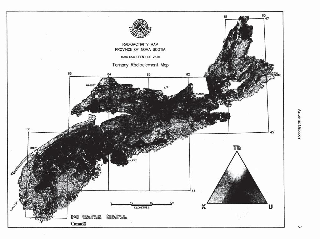
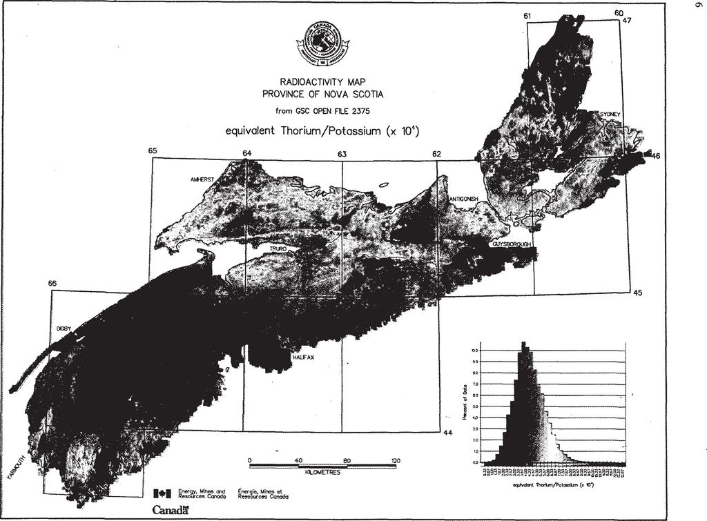
1 A tlantic Geol ogy 1 Radioactivity Maps of Nova Scotia K.L. Ford, P.B. Holman, J.A. Grant and J.M. Carson Airborne Geophysics Section, Mineral Resources Division, Geological Survey of Canada, 601 Booth Street, Ottawa, Ontario K1A 0E8, Canada Results of airborne gamma ray spectrometric surveys flown over the province of Nova Scotia by the Geological Survey of Canada between 1976 and 1990 have been published as a series of eight colour maps at 1:2,000,000 scale (Geological Survey of Canada Open File 2375). Four of these maps are reproduced here; the Ternary Radioelement Map, Potassium (pet), equivalent Uranium/equivalent Thorium, and equivalent Thorium/Potassium ratios. Other maps, not reproduced here, are Exposure Rate (ur/hr), equivalent Uranium (ppm), equivalent Thorium (ppm), and equivalent Uranium/Potassium ratio. Most of these data were previously released as 1:50,000-scale black-line contour maps and as a series of eight, 1:500,000-scale colour radioactivity maps of Nova Scotia (Ford etal., 1989). All data were collected using 50 L of sodium iodide detectors flown at a nominal terrain clearance of 120 m, with a ground speed of 190 km/hr and a flight line spacing of 1000 m. Uranium, thorium and potassium counts were measured over one-second intervals. Flight line data were averaged and interpolated to a 250 x 250 m grid. The general principles of airborne gamma ray spectrometric surveying have been recently reviewed by Grasty et al. (1991). Several studies (Ford et al., 1989; O Reilly et al., 1988; Ford and O Reilly, 1985) have demonstrated that airborne gamma ray spectrometry is a valuable aid to regional and detailed bedrock and surficial geological mapping and multielement geochemical exploration in granitic terrains similar to that of the Meguma Zone in southern Nova Scotia. The radioelement distribution patterns as measured by the airborne surveys accurately reflect the relative variations in K, U and Th in the bedrock and surficial materials. Any interpretation for bedrock mapping applications, however, must involve an understanding of the Pleistocene geology. In areas where bedrock radioelement contrasts are reflected in associated overburden, the airborne gamma ray surveys provide excellent predictive tools for mapping both the Pleistocene and bedrock geology. In the granitic rocks of southern Nova Scotia, studies have shown that the radioelement distribution patterns are controlled by variations in magmatic differentiation and by superimposed effects of late- and/or post-magmatic metasomatism and hydrothermal alteration. The ability of the airborne gamma ray surveys to recognize areas of pervasively altered rocks or cryptic compositional zonation is an important application for granophile-element mineral deposits and, as has been shown in other areas (Charbonneau etal., 1992), some forms of precious and base metal mineralization. Requests for map products or digital gridded or line data may be directed to any of the authors or to Publications, Geological Survey of Canada, 601 Booth Street, Ottawa, Ontario K1A 0E8; Telephone (613) The accompanying geological map was supplied by Dr. D. Kontak, Nova Scotia Department of Natural Resources. C h a r b o n n e a u, B.W., S h iv e s, R.B.K., and L ega ul t, M Application of gamma spectrometry to gold exploration. In Geological Survey of Canada, Minerals Colloquium, Program with Abstracts, January 22-24, F o r d, K.L. and O R eil l y, G.A Airborne gamma ray spectrometric surveys as in indicator of granophile element specialization and associated mineral deposits in the granitic rocks of the Meguma Zone of Nova Scotia. In High Heat Production (HHP) Granites, Hydrothermal Circulation and Ore Genesis. Institution of Mining and Metallurgy, St. Austell, Cornwall, England, pp F o r d, K.L., C a r s o n, J.M., G r a n t, J.A., and H o l m a n, P.B Radioactivity Maps of Nova Scotia. Geological Survey of Canada, Geophysical Series Map 35006G, Scale 1:500,000. F o r d, K.L., M a cd o n a l d, M.A., F in c k, P.W., B o n e r, F.J., H a m, L.J., H o r n e, R.J., C o r e y, M.C., and G r a v e s, R.M Airborne gamma ray spectrometry, and bedrock and surficial geology of the Davis Lake Pluton. In Mines and Minerals Branch, Report of Activities, 1989, Part A. Edited by D.R. MacDonald and K.A. Mills. Nova Scotia Department of Mines and Energy, Report 89-3, pp G r a s t y, R.L., M e l l a n d e r, H., and P a r k e r, M Airborne gamma ray spectrometer surveying. International Atomic Energy Agency, Technical Reports Series No. 323, Vienna, 97 p. O Reil l y, G.A., C o r e y, M.C., and F o r d, K.L The role of airborne gamma ray spectrometry in bedrock mapping and mineral exploration: case studies from granitic rocks within the Meguma Zone, Nova Scotia. Maritime Sediments and Atlantic Geology, 24, pp Geological Survey of Canada Contribution No ATLANTIC GEOLOGY 28, 1-6 (1992) /92/ /0


2 N> E3 TRIASSIC / JURASSIC LEGEND F o r d et al. [ 1 UPPER CARBONIFEROUS PICTOU. CUMBERLAND, d RIVERSDALE, CANSO LOWER CARBONIFEROUS n DEVONO-CARBONIFEROUS HORTON. WINDSOR WII\ DEVONO-CARBONIFEROUS iggg SILURIAN SILURIAN FOUNTAIN LAKE GROUP NEW CANAAN, WHITE ROCK ARISAIG SCALE km 50 miles H ill CAMBRO ORDOVICIAN CAMBRIAN / HADRYNIAN MEGUMA GROUP BOURINOT GROUP FOURCHU GROUP GEORGEVILLE / JEFFERS GROUP HELIKIAN GRANITE / GRANODIORITE POLLETS COVE GROUP Simplified geological map of the province of Nova Scotia.
3

4 F o r d e t al.

5 61 ic G e o l o g y

6 F o r d e t al.
Radon Soil Gas Associated With the C2 Zone, Millet Brook Uranium District (NTS 21A/16)
") Report of Activities 2009 35 Radon Soil Gas Associated With the C2 Zone, Millet Brook Uranium District (NTS 21A/16) T. A. Goodwin, G. A. O Reilly, K. L. Ford 1 and P. W. B. Friske 1 Introduction Radon
Report of Activities 2009 35 Radon Soil Gas Associated With the C2 Zone, Millet Brook Uranium District (NTS 21A/16) T. A. Goodwin, G. A. O Reilly, K. L. Ford 1 and P. W. B. Friske 1 Introduction Radon
The North American Soil Geochemical Landscapes Project: Report on the 2008 Sampling Program and Preliminary 2007 Results 1
 Report of Activities 2008 45 The North American Soil Geochemical Landscapes Project: Report on the 2008 Sampling Program and Preliminary 2007 Results 1 T. A. Goodwin, E. M. McIsaac and P. W. B. Friske
CJP EXPLORATION INC.
 PO Box 219 14579 Government Road Larder Lake, Ontario P0K 1L0, Canada Phone (705) 643-1122 Fax (705) 643-2191 CJP EXPLORATION INC. Spectrometer Survey Over the SHEBA PROPERTY Nouvel Township, Ontario TABLE
Lin Chen Robert A Creaser Daniel J Kontak Oct 29th, 2014
 FURTHER Re-Os ARSENOPYRITE GEOCHRONOLOGY FROM SELECTED MEGUMA AU DEPOSITS, MEGUMA TERRANE, NOVA SCOTIA: POSSIBLE EVIDENCE FOR A PROTRACTED GOLD-FORMING SYSTEM Lin Chen Robert A Creaser Daniel J Kontak
XA TERRESTRIAL GAMMA DOSE RATE MAPS, THEIR COMPILATION AND VERIFICATION RADIOMETRIC MAP OF THE CZECH REPUBLIC
 TERRESTRIAL GAMMA DOSE RATE MAPS, THEIR COMPILATION AND VERIFICATION RADIOMETRIC MAP OF THE CZECH REPUBLIC XA9745936 M. MATOLIN Faculty of Science, Charles University, Prague, Czech Republic Abstract Maps
ASX Company Announcement
 ASX Company Announcement Yellow Rock Resources ACN: 116 221 740 35 Great Eastern Highway Rivervale WA 6103 Telephone: (08) 9361 5400 Facsimile: (08) 9361 5900 Email: info@aurium.com.au Companies Announcement
Volume 35 Numbers 3/4 September/December
 GEOSCIENCE CANADA Volume 35 Numbers 3/4 September/December 2008 109 SERIES Remote Predictive Mapping 2. Gamma-Ray Spectrometry: A Tool for Mapping Canada's North K. Ford 1, J. R. Harris, R. Shives 2,J.
Assessing soil wetness with airborne radiometric data
 Assessing soil wetness with airborne radiometric data David Beamish British Geological Survey, Keyworth, Nottingham, NG12 5GG, UK Corresponding author (e-mail:dbe@bgs.ac.uk) Extended Abstract 20 th European
State Metallic Minerals Lease Sale Minnesota s Vermilion Gold District
 State Metallic Minerals Lease Sale Minnesota s Vermilion Gold District State Metallic Minerals Lease Sale Notice of Intent Scale 1:100,000 State Metallic Minerals Lease Sale This portion of the lease sale
Introduction. Report of Activities T. G. MacHattie
 Report of Activities 2009 65 Magmatism, Alteration and Polymetallic Mineralization in Late Devonian to Early Carboniferous Felsic Volcanic and Plutonic Rocks of the Eastern Cobequid Highlands T. G. MacHattie
Spectrometer Survey Over the Creelman-Roberts Property Roberts and Creelman Townships, Ontario
 PO Box 19 1479 Government Road Larder Lake, Ontario PK 1L, Canada Phone (7) 4-11 Fax (7) 4-191 Spectrometer Survey Over the Creelman-Roberts Property Roberts and Creelman Townships, Ontario Spectrometer
Nova Scotia Gold Grain Study: Results from the 2007 Field Program to Examine Background Concentrations of Gold in Till
 Report of Activities 2007 21 Nova Scotia Gold Grain Study: Results from the 2007 Field Program to Examine Background Concentrations of Gold in Till T. A. Goodwin Introduction During the 2007 field season,
3. Radiometry. The Australian Continent: A Geophysical Synthesis Radiometry
 16 3. Radiometry A major effort has been made to assemble a continent-scale study combining the results of many different airborne radiometric surveys (Figure 3.1). The radiometric surveys measure the
The Hillsvale Vein System, Hants County
 Report of Activities 2004 39 The Hillsvale Vein System, Hants County R. J. Horne, R. R. Stea and D. J. Kontak Introduction A number of previously undocumented, beddingparallel quartz veins were discovered
Nova Scotia s Involvement in the North American Soil Geochemical Landscape Project
 Report of Activities 2007 29 Nova Scotia s Involvement in the North American Soil Geochemical Landscape Project T. A. Goodwin Introduction The objective of the North American Soil Geochemical Landscape
GEOPHYSICAL DATA SET (GDS) 1084B METADATA
 1084B METADATA") GEOPHYSICAL DATA SET (GDS) 1084B METADATA GENERAL INFORMATION Official Name of the Data Set or Information Holding: Ontario Airborne Geophysical Surveys, Magnetic Gradiometer and Gamma-Ray Spectrometric
GEOPHYSICAL DATA SET (GDS) 1084B METADATA GENERAL INFORMATION Official Name of the Data Set or Information Holding: Ontario Airborne Geophysical Surveys, Magnetic Gradiometer and Gamma-Ray Spectrometric
THE USE OF GAMMA RAY DATA TO DEFINE THE NATURAL RADIATION ENVIRONMENT
 IAEA-TECDOC-566 THE USE OF GAMMA RAY DATA TO DEFINE THE NATURAL RADIATION ENVIRONMENT A TECHNICAL DOCUMENT ISSUED BY THE INTERNATIONAL ATOMIC ENERGY AGENCY, VIENNA, 1990 The SAEA does not normally maintain
Placer Potential Map. Dawson L and U se P lan. Jeffrey Bond. Yukon Geological Survey
 Placer Potential Map Dawson L and U se P lan By Jeffrey Bond Yukon Geological Survey Dawson Land Use Plan Placer Potential Map 1.0 Introduction Placer mining has been an important economic driver within
Processing and Enhancement of East Kemptville Airborne Magnetometer Survey
 M I N E R A L R E S O U R C E S B R A N C H Processing and Enhancement of East Kemptville Airborne Magnetometer Survey Open File Report ME 2006-1 M. S. (Steve) King Honourable Brooke D. Taylor Minister
CJP EXPLORATION INC.
 CJP Exploration Inc. Larder Lake, Ontario P0K1L0 CJP EXPLORATION INC. Spectrometer Survey Over the TANNAHILL GOLD PROPERTY TABLE OF CONTENTS 1. SURVEY DETAILS... 3 1.1 PROJECT NAME... 3 1.2 CLIENT... 3
Developments in the Standardization and Analysis of Airborne Gamma-Ray Data
 Radiometric Methods and Remote Sensing Paper 95 Explor97 Master Page Explor97 Contents G O T O Author Index Section Contents Next Paper Developments in the Standardization and Analysis of Airborne Gamma-Ray
CORPORATE PROFILE Airborne Geophysics for Mineral Exploration
 CORPORATE PROFILE Airborne Geophysics for Mineral Exploration Highlights Specialists in high resolution airborne geophysical surveys in mountainous terrain Precision GeoSurveys is a full-service airborne
Geochemistry and genesis of Darb-e-Behesht porphyric copper index, South Kerman, Iran
 Bulgarian Chemical Communications, Volume 48, Special Issue D (pp. 300-305) 2016 Geochemistry and genesis of Darb-e-Behesht porphyric copper index, South Kerman, Iran K. Noori Khankahdani 1*, H. Motavassel
Sustainable Management of Mineral Resources Project
 AIRBORNE GEOPHYSICS AS A TOOL TO PROM OTE M INERAL INVESTMENT IN AFRICA Stephen Re ford,k arl KwaiT2^Julius Nyakama3,Andre w Katum wehe4, Oumar Wane5 Paterson,Grant % Watson Limited,Toronto,Canada,Stephen.
AERO RADIOACTIVITY CHAPTER25 INTRODUCTION AVAILABLE DATA. Part IV. Regional Geophysics
 Part IV. Regional Geophysics CHAPTER25 AERO RAIOACTIVITY ELIZABETH R. KING U.S. Geological Survey National Center, MS 927 Reston, VA 20192 JOSEPHS. UVAL U.S. Geological Survey National Center, MS 927 Reston,
Bureau of Mineral Resources, Geology & Geophysics
 Bureau of Mineral Resources, Geology & Geophysics Record No. 1989/8 CALIBRATION OF THE BMR AIRBORNE GAMMA-RAY SPECTROMETERS UPWARD-LOOKING DETECTOR, FEBRUARY 1989. r & ) COl\IPACn;~ ~ - 1) by B.R.S. Minty
Mapping a Tensional Shear-related Auriferous Zone in the Meander River at Greenhill, Hants County
 Report of Activities 2010 111 Mapping a Tensional Shear-related Auriferous Zone in the Meander River at Greenhill, Hants County R. F. Mills The Meander River area of Hants County has been known to produce
SINGULARITY ANALYSIS FOR IMAGE PROCESSING AND ANOMALY ENHANCEMENT. Qiuming CHENG
 SINGULARITY ANALYSIS FOR IMAGE PROCESSING AND ANOMALY ENHANCEMENT Qiuming CHENG Department of Earth and Atmospheric Science, Department of Geography, York University, Toronto, 4700 Keele Street, Ont. M3J
New mapping of natural and manmade radioactivity
 New mapping of natural and manmade radioactivity Cathy Scheib and Dave Jones Acknowledgements: Tellus and JAC teams; Don Appleton (BGS); Jon Miles & Martyn Green (HPA); Robert Lamour (EHSNI); David Sanderson
Airborne Geophysical Survey Report River Jordan Property
 Airborne Geophysical Survey Report River Jordan Property Prepared for: Inc. September 3, 2009 Precision GeoSurveys Inc. 520-355 Burrard Street, Vancouver, Canada V6C 2G8 www.precisiongeosurveys.com Table
CORRELATIONS AMONG MINERALOGICAL AND SPECIFIC GRAVITY DATA FROM A GRANODIORITE PLUTON 1
 CORRELATIONS AMONG MINERALOGICAL AND SPECIFIC GRAVITY DATA FROM A GRANODIORITE PLUTON 1 J. ALLAN CAIN Geology Department, Western Reserve University, Cleveland, Ohio In the current efforts to quantify
Projects and
 DRIFT PROSPECTING IN THE DISTRICT OF KEEWATIN - URANIUM AND BASE METALS Projects 700014 and 750074 W. W. Shilts and R. A. Klassen Studies of trace metal distribution in till were continued in the Yandle-Henninga
Bibliography of Mining, Assessment and Other NSDNR Reports Reviewed during the Study.
 Bibliography of Mining, Assessment and Other NSDNR Reports Reviewed during the Study. Search word: Isaac's Harbour Barrett, A. M. Gold, Isaacs Harbour, Guysborough County, Nova Scotia. Report on the Potential
White Paper - SkyTEM Multi Geophysical Airborne Surveys
 White Paper - SkyTEM Multi Geophysical Airborne Surveys (TDEM / Magnetic and Gamma-Ray Spectrometry) Tomas Grand Han Limburg Bill Brown SkyTEM Surveys Medusa BV SkyTEM Surveys Denmark The Netherlands Denmark
MOKWA (Sheet 41) 1:250,000 GEOPHYSICAL MAP SERIES AND INTERPRETATION
 1:250,000 GEOPHYSICAL MAP SERIES AND INTERPRETATION") TECHNICAL ASSISTANCE FOR THE INTERPRETATION OF AIRBORNE GEOPHYSICAL SURVEY Contract No. SMMRP/C.2.1/CON/07/02 MOKWA (Sheet 41) 1:250,000 GEOPHYSICAL MAP SERIES AND INTERPRETATION Prepared for Federal Republic
TECHNICAL ASSISTANCE FOR THE INTERPRETATION OF AIRBORNE GEOPHYSICAL SURVEY Contract No. SMMRP/C.2.1/CON/07/02 MOKWA (Sheet 41) 1:250,000 GEOPHYSICAL MAP SERIES AND INTERPRETATION Prepared for Federal Republic
TIGER GOLD EXPLORATION CORPORATION
 PO Box 219, 14579 Government Road, Larder Lake, Ontario, P0K 1L0, Canada Phone (705) 643-2345 Fax (705) 643-2191 www.cxsltd.com TIGER GOLD EXPLORATION CORPORATION Spectrometer Survey Over the HARKER HERITAGE
EXISTING GEOLOGICAL INFORMATION
 CHAPER 3 EXISTING GEOLOGICAL INFORMATION 3-1 General Geology of the Surrounding Area (1) General geology and ore deposits in Mongolia Geographically, Mongolia is a country located between Russia to the
For personal use only
 VICTORIAN PORPHYRY COPPER GOLD TENEMENTS GRANTED ASX ANNOUNCEMENT 13 AUGUST 2013 Mantle Mining Corporation Limited (ASX: MNM) is pleased to report that three exploration licences highly prospective for
GEOCHEMISTRY UNIFORM SYLLABUS
 GEOCHEMISTRY UNIFORM SYLLABUS The Association of Professional Engineers and Geoscientists of the Province of British Columbia Note: 1. This Syllabus May Be Subject To Change 2. These Courses Are Required
QUANTITATIVE Cs-137 DISTRIBUTIONS FROM AIRBORNE GAMMA RAY DATA
 QUANTITATIVE Cs-137 DISTRIBUTIONS FROM AIRBORNE GAMMA RAY DATA XA9745947 G. OBERLERCHER, W. SEIBERL Geological Survey of Austria, Vienna, Austria Abstract The Chernobyl reactor accident caused in Austria
Sustainable Natural Resources Development on a Small Planet. Mineral Exploration
 Sustainable Natural Resources Development on a Small Planet Mineral Exploration Exploration the mining industry s principal activity in research and development Scientific and engineering principles used
SIXTH SCHEDULE REPUBLIC OF SOUTH SUDAN MINISTRY OF PETROLEUM, MINING THE MINING (MINERAL TITLE) REGULATIONS 2015
 REGULATIONS 2015") SIXTH SCHEDULE REPUBLIC OF SOUTH SUDAN MINISTRY OF PETROLEUM, MINING THE MINING ACT, 2012 THE MINING (MINERAL TITLE) REGULATIONS 2015 Guidelines should be prepared by the Directorate of Mineral Development
SIXTH SCHEDULE REPUBLIC OF SOUTH SUDAN MINISTRY OF PETROLEUM, MINING THE MINING ACT, 2012 THE MINING (MINERAL TITLE) REGULATIONS 2015 Guidelines should be prepared by the Directorate of Mineral Development
SQUARE POST PROJECT CHARTERS TOWERS NORTH QUEENSLAND AUSTRALIA
 SQUARE POST PROJECT CHARTERS TOWERS NORTH QUEENSLAND AUSTRALIA Square Post - Summary PROJECT DETAILS - SQUARE POST The Square Post exploration permit (EPM 18510) contains two styles of mineralisation:
GEOPHYSICS GRAVITY DATA COVERAGE
 GEOPHYSICS DATA COVERAGE The Mudgee-Gulgong district lies within the Dubbo 1:250,000 sheet area. This area is now covered by high res_olution gravity, magnetic and radiometric data. The aeromagnetic and
Earth History Exam. The remains of an early dinosaur could be found at reference point A. A B. B C. C D. D. page 1
 Name: Date: 1. Base your answer(s) to the following question(s) on the Earth Science Reference Tables and your knowledge of Earth science. The accompanying cross section shows undisturbed sedimentary bedrock.
Geophysical Surveys of the Continental Shelf South of Nova Scotia* PETER HOOD Geophysics Division, Geological Survey of Canada,
 Reports 6 Geophysical Surveys of the Continental Shelf South of Nova Scotia* PETER HOOD Geophysics Division, Geological Survey of Canada, Ottawa. A number of geophysical exploration programs have been
Report on The Magnetic Survey. Property of Loydex Resources Inc. Keigat Lake Area. Red Lake Mining Division
 010 Report on The Magnetic Survey On The Property of Loydex Resources Inc. SANDY POINT PROJECT Keigat Lake Area District of Kenora, Patricia Portion Red Lake Mining Division N.T.S. 52-N-8 Whitby, Ontario
r ffj Ronald C. Wells, BSc. Lacana Mining Corporation LACANA CLAIMS GAUTMER TOWNSMP GEOPHYSICAL REPORT OCT LARDER LAKE MINING DIVISION
 a- 32D04NWei39 2.3507 GAUTHIER 010 GEOPHYSICAL REPORT LACANA CLAIMS GAUTMER TOWNSMP LARDER LAKE MINING DIVISION RECEIVED OCT171980 MINING UNDS SECTION Author: Ronald C. Wells, BSc. Lacana Mining Corporation
Proton Magnetometer Signatures over Mineralized Basal Windsor Group Transects in Hants and Halifax Counties, Nova Scotia
 Report of Activities 2008 103 Proton Magnetometer Signatures over Mineralized Basal Windsor Group Transects in Hants and Halifax Counties, Nova Scotia R. F. Mills Introduction Regional Economic Geology
Introduction. Local Geology. Moose River. R. F. Mills and J. D. Chipman
 Report of Activities 2005 115 Investigation of Tills as Placer Ore Sources at Lake Catcha (NTS 11D/11) and Moose River (NTS 11D/15), Halifax County, and Kemptville (NTS 21A/04), Yarmouth County R. F. Mills
GEOPHYSICAL MAPS AND PETROPHYSICAL DATA OF MOZAMBIQUE
 Geophysical maps and petrophysical data of Mozambique GTK Consortium Geological Surveys in Mozambique 2002 2007, edited by Yrjö Pekkala, Tapio Lehto & Hannu Mäkitie, 65 80, 2008 GEOPHYSICAL MAPS AND PETROPHYSICAL
HISTORICAL GEOLOGY. Relative & Absolute age, fossils and geologic time
 HISTORICAL GEOLOGY Relative & Absolute age, fossils and geologic time Historical Geology A. Measuring Time 1. Relative Time (Relative Age) Measurement of time using comparison. No numbers used; uses words
Biology. Slide 1 of 40. End Show. Copyright Pearson Prentice Hall
 Biology 1 of 40 2 of 40 Fossils and Ancient Life What is the fossil record? 3 of 40 Fossils and Ancient Life The fossil record provides evidence about the history of life on Earth. It also shows how different
31C15NWW PALMERSTON REPORT ON AN AIRBORNE RADIOMETRIC AND MAGNETIC SURVEY PART OF PALMERSTON TOWNSHIP, ONTARIO TOR J.P.
 31C15NWW74 2.2248 PALMERSTON 1976 010 UNIX REPORT ON AN AIRBORNE RADIOMETRIC AND MAGNETIC SURVEY OF PART OF PALMERSTON TOWNSHIP, ONTARIO TOR J.P. JEWELL Flown and Compiled by GEOTERREX LIMITED Ottawa,
RETAIL STAR LIMITED EXPLORATION UPDATE MALAWI EXPLORATION HIGHLIGHTS
 Retail Star Limited Level 9, 440 Collins Street, Melbourne Vic 2000 P. +61 3 9607 1322 F. +61 3 9607 1329 www.retailstar.net.au ABN 71 098 238 585 7 July 2008 RETAIL STAR LIMITED EXPLORATION UPDATE MALAWI
Introduction. T. A. Goodwin
 Report of Activities 2006 55 Nova Scotia Gold Grain Study: Background and Anomalous Concentrations of Gold Grains in Till from the Beaver Dam Gold District (NTS 11E/02) and Hillsvale (11D/13) Areas T.
LONG LAKE ZINC MINE. Selected References "Zinc and Lead Deposits of Canada'% Geol. Surv. Can., Econ. Geol. Series, No k 8, 1930, pp, H6-151.
 April,1952 31CI8NW8eie 63.3149 OLDEN 010 ^ LONG LAKE ZINC MINE Selected References Alcock, P.J., "Zinc and Lead Deposits of Canada'% Geol. Surv. Can., Econ. Geol. Series, No k 8, 1930, pp, H6-151. Harding,
SANDER GEOPHYSICS LW 42D13SW ISLE ST. IGNACE RICHMONl
 SANDER GEOPHYSICS LW 42D13SW8363 83.1-117 ISLE ST. IGNACE 010 1305 RICHMONl REPORT ON THE HELICOPTER BORNE EM AND MAGNETOMETER SURVEY OFF ST. IGNACE ISLAND, LAKE SUPERIOR THUNDERBAY MINING DISTRICT, ONTARIO
3. GEOLOGY. 3.1 Introduction. 3.2 Results and Discussion Regional Geology Surficial Geology Mine Study Area
 3. GEOLOGY 3.1 Introduction This chapter discusses the baseline study of the geology and mineralization characteristics of the mine study area. The study consolidates existing geological data and exploration
RADON EMANOMETRY CASE STUDIES IN NAMIBIA : THE SPITZKOPPE AND TUMAS URANIUM DEPOSITS
 RADON EMANOMETRY CASE STUDIES IN NAMIBIA : THE SPITZKOPPE AND TUMAS URANIUM DEPOSITS Dr. B. Corner 1, Dr. V. Osiyuk 2, S. Lytvyniuk 2, A. Kuchmin 2, and D. Verran 3 1. Corner Geophysics Namibia, branko@iafrica.com.na
14. Weathering and Regolith
 The Australian Continent: A Geophysical Synthesis Weathering and Regolith 123 14. Weathering and Regolith The regolith consists of the zone at the Earth's surface between fresh rock and the interface with
FURTHER DISCOVERY KM COPPER PROJECT
 FURTHER DISCOVERY KM COPPER PROJECT ASX Release 24 October 2011 VOYAGER RESOURCES LIMITED ACN 076 390 451 Level 1 / 33 Richardson Street WEST PERTH stralia Tel: +61 8 9200 6264 Fax: +61 8 9200 4469 Contact:
Nuclear techniques in mineral exploration, extraction, and processing
 Nuclear techniques in mineral exploration, extraction, and processing Overview of typical applications and the IAEA's activities in the field by Rolf J. Rosenberg and Jacques Guizerix Mineral raw materials
:^^^^.^:*^.-f.^ r--", y.;-., - :^--,.,:,-;. ^;^u;;:-4:-;:-c?\'rfe *.V. V '^-t?"' :"^4^'A^'-*""^ ::--^-*^ii^i' :'^'^
 43C88SW0176 9939 JACOBSON i ;^*X ' y-f-'v' - * - :- " v-v-vj- "'-, p,v- *.,-... ''- i,. --: ^j v i,:^ v.- ' *,..-.- x, S'J~ f;" V J *J ' :'i? "'. 'f ' -'"c,- ; i -- - -?-.-'.f ' -' ' -. '.f-,-,.~.~ -Ji-'.'-:
We are committed to providing accessible customer service. If you need accessible formats or communications supports, please contact us.
 We are committed to providing accessible customer service. If you need accessible formats or communications supports, please contact us. Nous tenons à améliorer l accessibilité des services à la clientèle.
STRONG GOLD IN SOIL ANOMALY OUTLINED AT MARY HARRISON PROJECT HIGHLIGHTS
 National Stock Exchange of Australia Company Announcements Level 2, 117 Scott Street Newcastle NSW 2300 25 th January 2013 STRONG GOLD IN SOIL ANOMALY OUTLINED AT MARY HARRISON PROJECT HIGHLIGHTS 100m
The Fossil Record. CELLS and HEREDITY, CHAPTER 5, SECTION 3, PAGES 155 to 163
 The Fossil Record CELLS and HEREDITY, CHAPTER 5, SECTION 3, PAGES 155 to 163 Objectives 1. Describe how most fossils form. 2. Explain how scientists can determine a fossil s age. 3. Identify some unanswered
Chapter 3 Time and Geology
 Chapter 3 Time and Geology Methods of Dating Rocks 1. Relative dating - Using fundamental principles of geology (Steno's Laws, Fossil Succession, etc.) to determine the relative ages of rocks (which rocks
17-1 The Fossil Record Slide 2 of 40
 2 of 40 Fossils and Ancient Life What is the fossil record? 3 of 40 Fossils and Ancient Life Fossils and Ancient Life Paleontologists are scientists who collect and study fossils. All information about
MAYO LAKE MINERALS INC
 MAYO LAKE MINERALS INC FOR IMMEDIATE RELEASE Press release 2012-01 MAYO LAKE GEOPHYSICAL SURVEY IDENTIFIES 27 PROSPECTIVE GOLD/SILVER TARGETS OTTAWA, ONTARIO, May 29 th, 2012: Mayo Lake Minerals Inc. (MLM)
Evolution of the Slave Province and Abitibi Subprovince Based on U-Pb Dating and Hf Isotopic Composition of Zircon
 Evolution of the Slave Province and Abitibi Subprovince Based on U-Pb Dating and Hf Isotopic Composition of Zircon John W.F. Ketchum 1, Wouter Bleeker 2, William L. Griffin 1, Suzanne Y. O Reilly 1, Norman
CHAPTER 4 POTENTIAL FIELD MODELLING
 CHAPTER 4 POTENTIAL FIELD MODELLING POTENTIAL FIELD MODELLING The reference dataset used for the potential field modelling is the Gravity anomaly map and Magnetic anomaly map of the Atlantic region of
Soil and Till Geochemistry of the Halifax Regional Municipality, Nova Scotia
 Report of Activities 2002 41 Soil and Till Geochemistry of the Halifax Regional Municipality, Nova Scotia T. A. Goodwin Introduction Historically, there has been a general lack of geochemical sample sites
REPORT. ISSN: (print) ISSN: (online)
 ISSN: (online)") REPORT Geological Survey of Norway P.O.Box 6315 Sluppen NO-7491 TRONDHEIM Tel.: 47 73 90 40 00 Report no.: 2015.056 ISSN: 0800-3416 (print) ISSN: 2387-3515 (online) Grading: Open Title: Helicopter-borne
REPORT Geological Survey of Norway P.O.Box 6315 Sluppen NO-7491 TRONDHEIM Tel.: 47 73 90 40 00 Report no.: 2015.056 ISSN: 0800-3416 (print) ISSN: 2387-3515 (online) Grading: Open Title: Helicopter-borne
SAMPLE QUESTIONS FOR GEOLOGY 103, TEST 1
 SAMPLE QUESTIONS FOR GEOLOGY 103, TEST 1 The correct answers are listed at the bottom (no peeking!). These questions are to give you an idea of the type of questions that will be asked. They are not a
The McPhillamys Gold Deposit, Discovery History & Geology. Presenter: Tara French
 The McPhillamys Gold Deposit, Discovery History & Geology. Presenter: Tara French Forward-Looking Statements This presentation contains forward-looking statements. without limitation: Estimates of future
RADON EMANOMETRY IN URANIUM EXPLORATION USING ACTIVATED CHARCOAL : NAMIBIAN CASE STUDIES. Dr. B. Corner*, H. Sinclair** and D.
 RADON EMANOMETRY IN URANIUM EXPLORATION USING ACTIVATED CHARCOAL : NAMIBIAN CASE STUDIES Dr. B. Corner*, H. Sinclair** and D. Verran** Remote Exploration Services (Pty) Ltd * P. O. Box 2055 ** P.O Box
Numerical modeling of Z-TEM (airborne AFMAG) responses to guide exploration strategies Bob Lo*, Geotech Ltd., Michael Zang, Exploration Syndicate Inc.
 responses to guide exploration strategies Bob Lo*, Geotech Ltd., Michael Zang, Exploration Syndicate Inc.") Bob Lo*, Geotech Ltd., Michael Zang, Exploration Syndicate Inc. Summary Mineral exploration using the Z-TEM or Z-Axis Tipper Electromagnetics, an airborne AFMAG system, has been guided by numerical modeling
Bob Lo*, Geotech Ltd., Michael Zang, Exploration Syndicate Inc. Summary Mineral exploration using the Z-TEM or Z-Axis Tipper Electromagnetics, an airborne AFMAG system, has been guided by numerical modeling
Report of Gridding and Magnetic Surveys. On the. Munro Property. Munro and Beatty Townships, Ontario. Larder Lake Mining Division
 Report of Gridding and Magnetic Surveys On the Munro Property Munro and Beatty Townships, Ontario Larder Lake Mining Division Claims: 39 4244 For Big Red Diamond Corporation October 3, 2 Timmins, Ontario
Fox 2-Record No. 2524
 F HELICOPTER E.M. AND MAGNETOMETER SURVEY OVER THE FOX CLAIMS, OMINECA MINING DISTRICT BRITISH COLUMBIA ON BEHALF OF OWNER MR. MIKE BOYLE Claims: Fox l-record No. 2523 Fox 2-Record No. 2524 Location 126'
Chapter 3 Time and Geology
 Chapter 3 Time and Geology Finding the age of rocks: Relative versus Actual Dating The science that deals with determining the ages of rocks is called geochronology. Methods of Dating Rocks 1. Relative
Prospectivity Modelling of Granite-Related Nickel Deposits Throughout Eastern Australia
 Prospectivity Modelling of Granite-Related Nickel Deposits Throughout Eastern Australia M P Hill 1 and A McCarthy 2 ABSTRACT Spatial modelling has been used to determine potential locations of granite-related
Assessment Report by the Canadian Nickel Co. Ltd. Magnetometer Survey. Larder Lake Mining Division Lebel Tovnship, Ontario
 32084Nwea67 2.331* LEBEL 010 Assessment Report by the Canadian Nickel Co. Ltd. Magnetometer Survey Larder Lake Mining Division Lebel Tovnship, Ontario Claims L-531657 L-531658 L-531111 Map No.: M-359,
MAYO LAKE MINERALS INC
 MAYO LAKE MINERALS INC FOR IMMEDIATE RELEASE Press release 2014-05 Gold-Arsenic-Antimony Anomalies on Anderson Claim Group Follow-up Sampling on Davidson, Edmonton and Roop Claim Groups OTTAWA, ONTARIO,
INTRODUCTION Prospectivity mapping Study area and methods
 Quaternary geological and till geochemical studies in verifying GIS-based prospectivity mapping in the Central Lapland Greenstone Belt, northern Finland Sarala Pertti, Nykänen Vesa, Sarapää Olli, Peltoniemi
SUPPLEMENT TO MAGNETOMETER 6 ELECTROMAGNETIC SURVEY REPORT. DATED NOVEMBER l, 1973 CIGLEN INVESTMENTS LIMITED CLAIMS GROUP BAD VERMILLION LAKE AREA
 ^ A R l ^ 1974 010 PROJECTS UNIT SUPPLEMENT TO MAGNETOMETER 6 ELECTROMAGNETIC SURVEY REPORT DATED NOVEMBER l, 1973 CIGLEN INVESTMENTS LIMITED CLAIMS GROUP BAD VERMILLION LAKE AREA DISTRICT OF RAINY RIVER
John A. Wakeford Noranda Exploration Co., Ltd, November 4, 1980 rinnnins, Ontario
 42CC1NEfc4e9 801101 ECHUM 010 " ' i-^y&sg?' '.. -.r. K;VW\\:.!^-*.]-^--'^-r-r^Pj^Q..-. ;,: v 1,;-'-,..- ^^-^^^^ysr-r^ijjfiv^jj. v -." ". '. ' "i - '' '. '':.;': s.'.ilv'., p...--'*l r-j@tw IP ^vt'.'v*:-^
GEOLOGY AND MINERAL RESOURCES OF INDIAN RESERVE 26
 ) 41HI3NW94I4 I R NO 26 1*A1 MANITOULIN ISLAND 010 -f?;. GEOLOGY AND MINERAL RESOURCES OF INDIAN RESERVE 26 September 16, 1975 D. G. Innes, Resident Geologist Sudbury District Ministry of Natural Resources
The Need for Regional Geological Datasets
 The Need for Regional Geological Datasets Dr. Eibhlín Doyle PGeo Geological Survey of Ireland Regional Data Why What Who Future 2006 Why? Place developments in context Land use decision making Assist policy
Observations on a Veined Section of Core Drilled at Blockhouse, Lunenburg County
 Report of Activities 2016-17 53 Observations on a Veined Section of Core Drilled at Blockhouse, Lunenburg County R. F. Mills and A. MacKay 1 The Blockhouse gold district (NTS 21A/08) lies approximately
For personal use only
 ASX ANNOUNCEMENT ACN 123 567 073 3 July 2014 NEW FRASER RANGE PROJECT AREA AT KITCHENER New 100%-owned exploration licence application covers 203km 2, situated on the Fraser Range Gravity High Enterprise
LOS AZULES April 2018
 April 2018 lies along the southern extensions of the highly productive Paleocene Mineral Belt in northern Chile that contains numerous important copper, gold and silver mines and projects, and to the south
MRD 229-Revised METADATA
 GENERAL INFORMATION MRD 229-Revised METADATA Official Name of the Data Set or Information Holding: Till Compositional Database: Investigation of the Overburden Signature of the Caribou Lake Greenstone
I DES TERRAINS DIVISION. D. F. VanDine TERRAIN SCIENCES RESOURCE INVENTORY - MACKFWIE. Scale 1 : 250,000. D. E. Lawrence LA DIV'3'QN DE LA SCIENCE
 GRAN- RESOURCE INVENTORY - MACKFWIE LAC BELOT NTS 96 L SW4 Scale 1 : 250,000 D. E. Lawrence D. F. VanDine For: Department of Indian and Northern Affairs TERRAIN SCIENCES DIVISION LA DIV'3'QN DE LA SCIENCE
17-1 The Fossil Record Slide 1 of 40
 1 of 40 Fossils and Ancient Life Fossils and Ancient Life Paleontologists are scientists who collect and study fossils. All information about past life is called the fossil record. The fossil record includes
Drilling Program Commences on Iron Oxide Copper Gold Targets
 3 June 2008 Manager Company Announcements Company Announcements Office Australian Stock Exchange Limited Level 10, 20 Bond Street SYDNEY NSW 2000 ABN 42 082 593 235 Electronic delivery No of pages: 6 Drilling
Andrew Lee BEng (Hons) CEng MIStructE FGS FPWS
 CEng MIStructE FGS FPWS") Jim Twaddle BSc (Hons) FGS Andrew Lee BEng (Hons) CEng MIStructE FGS FPWS 22 January 2010 ME50231/RE001 !! "# # $ " %! &' ( "# # $ ) # ' %! "# # $ # "# # $ * + # "# # $ "! # "# # $, # "# # $! -( +.!!/
Jim Twaddle BSc (Hons) FGS Andrew Lee BEng (Hons) CEng MIStructE FGS FPWS 22 January 2010 ME50231/RE001 !! "# # $ " %! &' ( "# # $ ) # ' %! "# # $ # "# # $ * + # "# # $ "! # "# # $, # "# # $! -( +.!!/
International Training Course on Uranium Exploration
 International Training Course on Uranium Exploration by P.M.C Barretto As part of its Technical Assistance Programme for developing countries, the IAEA has conducted a series of training courses in prospecting
Rock cycle diagram. Principle of Original Horizontality. Sediment is deposited horizontally
 Geologic Time Rock cycle diagram Leaves of History Chapter 21 Lateral Continuity Principle of Original Horizontality Sediment is deposited horizontally Principle of Superposition Oldest rock A Younger
w a. REPORT ON AIRBORNE GEOPHYSICS'SURVEY 'ON' ' ' ' ".' v- - - PRESTON EAST DC8CB PROPERTIES, SERPENT RIVER AREA
 O Q,... -... - REPORT ON AIRBORNE GEOPHYSICS'SURVEY 'ON' ' ' ' ".' -..- -..v- - - PRESTON EAST DC8CB PROPERTIES, A combined aeromagnetic and airborne scintillation counter survey was carried out by Aeromagnetic