New mapping of natural and manmade radioactivity
|
|
|
- Jason Ford
- 6 years ago
- Views:
Transcription
1 New mapping of natural and manmade radioactivity Cathy Scheib and Dave Jones Acknowledgements: Tellus and JAC teams; Don Appleton (BGS); Jon Miles & Martyn Green (HPA); Robert Lamour (EHSNI); David Sanderson & Alan Creswell (SUERC), Andrew Tyler, Stuart Bradley Kingsley Dunham Centre Keyworth Nottingham NG12 5GG Tel & Christopher Brodie (Stirling Uni ERL).
2 What does the radiometric data reflect, and what can it be used for? 1. Bedrock geology (compositional changes within mapped units); improved mapping/ understanding of zonation 2. Superficial geology and soil; improve maps, peat resources 3. Enhancement in natural concentrations and inputs ( 137 Cs) due to man s activities; environmental monitoring, diverse range of environmental studies 4. Overall gamma dose rate; uranium source of radon; health studies/ mitigation 5. Snapshot; baseline studies to assess future impacts 6. Direct and indirect indications of mineralisation; mineral exploration
3 K, eu, eth and 137 Cs Single element maps, total count, ratio maps and ternary images. Footprint at 56 m: approx 75 % from a width of about 150 m, extending to around 220 m along the flight line


4 Total Count & bedrock geology Sperrin Mountains Basalts Inlier Rhyolites Triassic Lower Lough Erne Dalradian & L Palaeozoic Carboniferous & Devonian S Uplands Terrane Intrusives Hawick Group


5 SE Northern Ireland: intrusives Ternary plot with solid geology lines Simplified solid geology

6 SE Northern Ireland: Th/K ratio with solid geology lines

7 Drumlins K % Shamullagh Formation Clogher Valley Fault Tempo-Sixmilecross Fault Also apparent in magnetic data/ geochemistry

8 Superficial deposits Glenelly River Owenkillew River Owenreagh River Sperrin Mountains: draped on topography, Looking NE K %


9 Visible on radiometric images Generally good correspondence with mapped boundaries- but not in all locations Improved information on peat would be valuable for a range of end uses Peat cover

10 Superficial deposits reflecting ice transport direction Rhyolite Looking N over basalts with bedrock geology line-work K %


11 Technological enhancement of natural radioactivity Total Count K % U ppm Th ppm

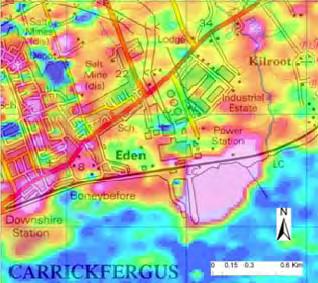
12 Carrickfergus power station: eth on air photo eth ppm


13 High Town landfill and area: K % on air photos
14 Gamma Dose Rate- ngy/h (Absorbed dose rate in air) Gamma Dose Rate means ngy/h 1. DOE for NI (max 103) 2. NRPB GB survey Tellus airborne 31 (max 320) 1. Terrestrial Gamma-ray Dose Rates Out Of Doors in Northern Ireland. Department of the Environment of Northern Ireland, Environmental Protection Division Environmental Monitoring Report 2 2. Green, B.M., Lomas, P.R., Bradley, E.J., Wrixon, A.D., Gamma radiation levels outdoors in Great Britain. NRPB- R-191.
15 Gamma Dose Rate- ngy/h Variation in dose rates reflect the natural variation in the K, U and Th.
16 Radon Pilot Study Probability of houses in Northern Ireland having high indoor radon concentrations is currently estimated on the basis of results of in-house radon measurements, grouped by 5-km grid squares. Scope for using K, eu, eth data and soil geochemical data to predict radon susceptibility. Data were compared statistically with the in-house radon measurements to determine the best combination of variables. Multivariate linear regression analysis was investigated as an alternative method for predicting indoor radon for areas where few indoor radon measurements are currently available.
 Modelled probability based on airborne eu-eth-k, ground permeability, and")
17 "These maps are provisional radon maps which should not be used in their present form for legislative (e.g. Building Regulations) purposes." Provisional estimated probability of exceeding the radon Action Level (Indoor radon measurements) Modelled probability based on airborne eu-eth-k, ground permeability, and soil Zr, Y, and SiO 2 (Tellus data)
18 137 Cs Man-made radionuclide (half-life of years) Sources: atmospheric weapons testing, authorised discharges & accidental releases Chernobyl 1986: Sheep restrictions- lifted in 2000 in NI
")

19 137 Cs: Wet deposition dominates (rainfall important) Topographical controls Coastal highs (marine discharges) Post-depositional redistribution into valleys in areas of organic soil Coleraine Ballycastle Re-distribution of 137 Cs into valleys Ballymoney 25 km 25 km

")


20 National scale: Preliminary 137 Cs data Reflect rainfall (Chernobyl plume) (Long-term averageweapons testing) Processing artefact? Independent studies confirmed majority of data Highlighted some flight lines affected by radon in air
21 Conclusions Data show clear relationships to bedrock geology, superficial geology and soils. Human influence is seen from extractive and power generation industries, and waste disposal. Combined with geochemical and permeability data, can be used to help predict radon susceptibility. Provides valuable baseline data. Combined with other geophysical datasets, can aid mineral exploration, mapping and a wide range of environmental applications.
18. Mapping the terrestrial gamma radiation dose
 18. Mapping the terrestrial gamma radiation dose David Beamish 1 How to cite this chapter: Beamish, D., 2016 Mapping the terrestrial gamma radiation dose in M.E. Young (ed.), Unearthed: impacts of the
Assessing soil wetness with airborne radiometric data
 Assessing soil wetness with airborne radiometric data David Beamish British Geological Survey, Keyworth, Nottingham, NG12 5GG, UK Corresponding author (e-mail:dbe@bgs.ac.uk) Extended Abstract 20 th European
Tellus Border Project Overview. Marie Cowan Ph.D Project Manager
 Tellus Border Project Overview Marie Cowan Ph.D Project Manager Presentation Outline History Goals Partners Project summary Legislative Framework Data Impacts Tellus History Proposed by GSNI, GSI, and
Does the SDCP need inputs from geology?
 The British Geological Survey s Experience and Expertise in Supporting Projects such as the Sirte Depression Connection Project David Ovadia Director of International Kingsley Dunham Centre Keyworth Nottingham
What is the scope for carbon capture and storage in Northern Ireland. Michelle Bentham
 What is the scope for carbon capture and storage in Northern Ireland Michelle Bentham Kingsley Dunham Centre Keyworth Nottingham NG12 5GG Tel 0115 936 3100 What is Carbon Capture and Storage? Capture of
Soil uranium, soil gas radon and indoor radon empirical relationships in the UK and other European countries
 Soil uranium, soil gas radon and indoor radon empirical relationships in the UK and other European countries Don Appleton (BGS) and Jon Miles (HPA) EUROPEAN GEOGENIC RADON POTENTIAL MAP Wide range of numerical
XA TERRESTRIAL GAMMA DOSE RATE MAPS, THEIR COMPILATION AND VERIFICATION RADIOMETRIC MAP OF THE CZECH REPUBLIC
 TERRESTRIAL GAMMA DOSE RATE MAPS, THEIR COMPILATION AND VERIFICATION RADIOMETRIC MAP OF THE CZECH REPUBLIC XA9745936 M. MATOLIN Faculty of Science, Charles University, Prague, Czech Republic Abstract Maps
User Guide: RADON POTENTIAL DATASET - England and Wales
 User Guide: RADON POTENTIAL DATASET - England and Wales This document provides information for users of the joint HPA-BGS RADON POTENTIAL DATASET for England and Wales. 1. Background to joint Health Protection
20. Modelling in-house radon potential using Tellus data and geology to supplement inhouse radon measurements
 20. Modelling in-house radon potential using Tellus data and geology to supplement inhouse radon measurements Don Appleton 1 and James Hodgson 2 How to cite this chapter: Appleton, J.D. and Hodgson, J.A.,
Common Exploration Methods.
 Common Exploration Methods. The following list contains the most common methods which a company with a mineral prospecting licence in Northern Ireland might use to carry out a mineral prospecting programme.
Radioactivity measurements and risk assessments in soil samples at south and middle of Qatar
 Radioactivity measurements and risk assessments in soil samples at south and middle of Qatar A. T. Al-Kinani*, M. A. Amr**, K. A. Al-Saad**, A. I. Helal***, and M. M. Al Dosari* *Radiation and Chemical
Andrew Lee BEng (Hons) CEng MIStructE FGS FPWS
 CEng MIStructE FGS FPWS") Jim Twaddle BSc (Hons) FGS Andrew Lee BEng (Hons) CEng MIStructE FGS FPWS 22 January 2010 ME50231/RE001 !! "# # $ " %! &' ( "# # $ ) # ' %! "# # $ # "# # $ * + # "# # $ "! # "# # $, # "# # $! -( +.!!/
Jim Twaddle BSc (Hons) FGS Andrew Lee BEng (Hons) CEng MIStructE FGS FPWS 22 January 2010 ME50231/RE001 !! "# # $ " %! &' ( "# # $ ) # ' %! "# # $ # "# # $ * + # "# # $ "! # "# # $, # "# # $! -( +.!!/
Geology Map Extracts. Geology Map Extracts. Report prepared for: Orkney Sustainable Energy Ltd 6 North End Road Stromness Orkney KW16 3AG
 Report prepared for: Orkney Sustainable Energy Ltd 6 North End Road Stromness Orkney KW16 3AG Geology Map Extracts This report is designed for users carrying out preliminary site assessments who require
Uncertainties in radon related to house specific factors and proximity to geological boundaries in England
 Uncertainties in radon related to house specific factors and proximity to geological boundaries in England NEZAHAT HUNTER a, 1, COLIN R MUIRHEAD a, JON C H MILES a DONALD APPLETON b a Health Protection
Radon Soil Gas Associated With the C2 Zone, Millet Brook Uranium District (NTS 21A/16)
") Report of Activities 2009 35 Radon Soil Gas Associated With the C2 Zone, Millet Brook Uranium District (NTS 21A/16) T. A. Goodwin, G. A. O Reilly, K. L. Ford 1 and P. W. B. Friske 1 Introduction Radon
Report of Activities 2009 35 Radon Soil Gas Associated With the C2 Zone, Millet Brook Uranium District (NTS 21A/16) T. A. Goodwin, G. A. O Reilly, K. L. Ford 1 and P. W. B. Friske 1 Introduction Radon
Deposited on: 30 January 2012
 Cresswell, A. (2012) Recovery and reanalysis of archived airborne gamma spectrometry data from the 1991 Dounreay survey. Applied Radiation and Isotopes, 70 (1). pp. 216-221. ISSN 0969-8043 http://eprints.gla.ac.uk/59481/
Radon levels in the area surrounding East Northants Resource Management Facility
 Radon levels in the area surrounding East Northants Resource Management Facility Summary Radon information for the area and villages around the ENRMF has been obtained. The information shows that in the
Radioactivity Maps of Nova Scotia
 A tlantic Geol ogy 1 Radioactivity Maps of Nova Scotia K.L. Ford, P.B. Holman, J.A. Grant and J.M. Carson Airborne Geophysics Section, Mineral Resources Division, Geological Survey of Canada, 601 Booth
Assessing our untapped energy resources. Derek Reay Geological Survey of Northern Ireland
 Assessing our untapped energy resources Derek Reay Geological Survey of Northern Ireland Talk Outline Northern Ireland energy market Oil and Gas Exploration Description Exploration risks Application of
20. Modelling in-house radon potential using Tellus data and geology to supplement inhouse radon measurements
 20. Modelling in-house radon potential using Tellus data and geology to supplement inhouse radon measurements Don Appleton 1 and James Hodgson 2 How to cite this chapter: Appleton, J.D. and Hodgson, J.A.,
Soil uranium, soil gas radon and indoor radon empirical relationships in the UK and other European countries.
 Soil uranium, soil gas radon and indoor radon empirical relationships in the UK and other European countries. J D Appleton 1 and JCH Miles 2 1 British Geological Survey, Keyworth, Nottingham NG12 5GG,
Developing a new National Radon Risk Map
 Developing a new National Radon Risk Map 2014 J. A. Hodgson, S. Carey and R. Scanlon Geological Survey of Ireland 2014 Developing a new national radon risk map Geological Survey of Ireland The Geological
THE USE OF GAMMA RAY DATA TO DEFINE THE NATURAL RADIATION ENVIRONMENT
 IAEA-TECDOC-566 THE USE OF GAMMA RAY DATA TO DEFINE THE NATURAL RADIATION ENVIRONMENT A TECHNICAL DOCUMENT ISSUED BY THE INTERNATIONAL ATOMIC ENERGY AGENCY, VIENNA, 1990 The SAEA does not normally maintain
Radiometric assessment of natural radioactivity levels around Mrima Hill, Kenya
 International Journal of the Physical Sciences Vol. 6(13), pp. 3105 3110, 4 July, 2011 Available online at http://www.academicjournals.org/ijps DOI: 10.5897/IJPS11.052 ISSN 1992-1950 2011 Academic Journals
QUANTITATIVE Cs-137 DISTRIBUTIONS FROM AIRBORNE GAMMA RAY DATA
 QUANTITATIVE Cs-137 DISTRIBUTIONS FROM AIRBORNE GAMMA RAY DATA XA9745947 G. OBERLERCHER, W. SEIBERL Geological Survey of Austria, Vienna, Austria Abstract The Chernobyl reactor accident caused in Austria
STUDIES ON THE AEROSOL RADIOACTIVITY LEVEL AND AIR QUALITY AROUND NUCLEAR RESEARCH INSTITUTE AREA
 STUDIES ON THE AEROSOL RADIOACTIVITY LEVEL AND AIR QUALITY AROUND NUCLEAR RESEARCH INSTITUTE AREA A. STOCHIOIU 1, F. MIHAI 1, C. STOCHIOIU 2 1 Horia Hulubei National Institute for Physics and Nuclear Engineering,
Golden Cross Resources
 Golden Cross Resources Labrador Uranium Joint Venture with Altius Resources Update - November 2007 Labrador Uranium - Canada LABRADOR URANIUM PROPERTIES Golden Cross Resources signed an agreement with
A radiometric airborne geophysical survey of the Isle of Wight
 A radiometric airborne geophysical survey of the Isle of Wight David Beamish and James C. White British Geological Survey, Keyworth, Nottingham, NG12 5GG, UK. Published in PGA, Special Issue, November
Airborne Geophysical Survey Report River Jordan Property
 Airborne Geophysical Survey Report River Jordan Property Prepared for: Inc. September 3, 2009 Precision GeoSurveys Inc. 520-355 Burrard Street, Vancouver, Canada V6C 2G8 www.precisiongeosurveys.com Table
Analysis of gross alpha, gross beta activities and beryllium-7 concentrations in surface air: their variation and statistical prediction model
 Iran. J. Radiat. Res., 2006; 4 (3): 155-159 Analysis of gross alpha, gross beta activities and beryllium-7 concentrations in surface air: their variation and statistical prediction model F.Arkian 1*, M.
A Survey of Environmental Rdiation in Gunma Prefecture
 A Survey of Environmental Rdiation in Gunma Prefecture M.Sugino1, S.Minato2, K.Kodaira2, M.Shiomo3 1 Gunma Prefectural College of Health Sciences 2 National Industrial Research Institute of Nagoya 3 National
GEOPHYSICAL MAPS AND PETROPHYSICAL DATA OF MOZAMBIQUE
 Geophysical maps and petrophysical data of Mozambique GTK Consortium Geological Surveys in Mozambique 2002 2007, edited by Yrjö Pekkala, Tapio Lehto & Hannu Mäkitie, 65 80, 2008 GEOPHYSICAL MAPS AND PETROPHYSICAL
RETAIL STAR LIMITED EXPLORATION UPDATE MALAWI EXPLORATION HIGHLIGHTS
 Retail Star Limited Level 9, 440 Collins Street, Melbourne Vic 2000 P. +61 3 9607 1322 F. +61 3 9607 1329 www.retailstar.net.au ABN 71 098 238 585 7 July 2008 RETAIL STAR LIMITED EXPLORATION UPDATE MALAWI
GEOLOGICAL CONTROLS ON RADON POTENTIAL IN SCOTLAND
 GEOLOGICAL CONTROLS ON RADON POTENTIAL IN SCOTLAND Scheib, C 1, Appleton J. D. 1, Miles J. C. H. 2, Green, B. M. R. 2, Barlow, T. S. 1, and D. G. Jones 1. 1 British Geological Survey, Keyworth, Nottingham
14. Weathering and Regolith
 The Australian Continent: A Geophysical Synthesis Weathering and Regolith 123 14. Weathering and Regolith The regolith consists of the zone at the Earth's surface between fresh rock and the interface with
The European Commission s science and knowledge service. Moderated discussion: Progress on European Geogenic Radon Mapping. Joint Research Centre
 The European Commission s science and knowledge service Joint Research Centre Moderated discussion: Progress on European Geogenic Radon Mapping 13 th GARRM, Prague, 15 September 2016 1 European Basic Safety
Tools for building and delivering 3D models Perspectives by the BGS
 Tools for building and delivering 3D models Perspectives by the BGS Holger Kessler (on behalf of the 3D community of BGS) Kingsley Dunham Centre Keyworth Nottingham NG12 5GG Tel 0115 936 3100 www.bgs.ac.uk/3dg
19. Soils and their radiometric characteristics
 19. Soils and their radiometric characteristics David Beamish 1 How to cite this chapter: Beamish, D., 2016 Soils and their radiometric characteristics in M.E. Young (ed.), Unearthed: impacts of the Tellus
7. Using soil geochemistry to investigate gold and base metal distribution and dispersal in the glaciated north of Ireland
 7. Using soil geochemistry to investigate gold and base metal distribution and dispersal in the glaciated north of Ireland Michael Dempster, 1 Mark Cooper, 2 Paul Dunlop 1 and Andreas Scheib 3 How to cite
Generalised geological units as a background for European Geogenic Radon Potential Map an example from the Czech Republic
 Generalised geological units as a background for European Geogenic Radon Potential Map an example from the Czech Republic Ivan Barnet, Petra Pacherová Czech Geological Survey, 11821 Prague 1, Klárov 3
Tellus Survey Frequently Asked Questions:
 Tellus Survey 2017 - Frequently Asked Questions: 1. What is Tellus? Tellus is a ground and airborne geoscience mapping programme, collecting chemical and geophysical data that will inform the management
Welsh Assembly Debate on the proposal to dump 300,000 tonnes of radioactively contaminated sediment into the Cardiff Grounds marine dispersal site
 Welsh Assembly Debate on the proposal to dump 300,000 tonnes of radioactively contaminated sediment into the Cardiff Grounds marine dispersal site As Assembly Members, you have to make a decision which
Economic information for planning
 Economic information for planning Fiona McEvoy Economic Geologist and GIS Specialist Kingsley Dunham Centre Keyworth Nottingham NG12 5GG Tel 0115 936 3100 Overview Original MIST project environmentally
Identification and characterization of scenarios de natural source, representation of the same ones by means of radiological maps.
 Identification and characterization of scenarios de natural source, representation of the same ones by means of radiological maps. Orlando Dominguez Ley, Eduardo Capote Ferrera, Dolores Alonso Abad, Reynaldo
Distribution of Radionuclide Concentration with Proximity to the Lagoon in Lagos State, Southwestern Nigeria
 Distribution of Radionuclide Concentration with Proximity to the Lagoon in Lagos State, Southwestern Nigeria Abstract T. J Ojo* B. O Afolayan Physics Unit of Science Technology Department, Federal Polytechnic,
3. Radiometry. The Australian Continent: A Geophysical Synthesis Radiometry
 16 3. Radiometry A major effort has been made to assemble a continent-scale study combining the results of many different airborne radiometric surveys (Figure 3.1). The radiometric surveys measure the
The Need for Regional Geological Datasets
 The Need for Regional Geological Datasets Dr. Eibhlín Doyle PGeo Geological Survey of Ireland Regional Data Why What Who Future 2006 Why? Place developments in context Land use decision making Assist policy
1/28/16. EGM101 Skills Toolbox. Map types. Political Physical Topographic Climate Resource Road. Thematic maps (use one of the above as backdrop)
") EGM101 Skills Toolbox Map types Political Physical Topographic Climate Resource Road Thematic maps (use one of the above as backdrop) Map Types Deriving information from maps Hydrographic Geological Soils
EGM101 Skills Toolbox Map types Political Physical Topographic Climate Resource Road Thematic maps (use one of the above as backdrop) Map Types Deriving information from maps Hydrographic Geological Soils
Radon potential mapping of the Tralee-Castleisland and Cavan areas (Ireland) based on airborne gamma-ray spectrometry and geology.
 based on airborne gamma-ray spectrometry and geology.") Radon potential mapping of the Tralee-Castleisland and Cavan areas (Ireland) based on airborne gamma-ray spectrometry and geology. Appleton J D 1, 4, Doyle E 2,5, Fenton D 3 and Organo C 3 1 British Geological
Radon potential mapping of the Tralee-Castleisland and Cavan areas (Ireland) based on airborne gamma-ray spectrometry and geology. Appleton J D 1, 4, Doyle E 2,5, Fenton D 3 and Organo C 3 1 British Geological
Regional Variation of Seasonal Behaviour for Indoor Radon Levels
 Int. Statistical Inst.: Proc. 58th World Statistical Congress, 2011, Dublin (Session CPS006) p.3924 Regional Variation of Seasonal Behaviour for Indoor Radon Levels Burke, Órlaith University of Oxford,
Douglas Millican Chief Executive Scottish Water Castle House 6 Castle Drive DUNFERMLINE KY11 8GG Our Reference: 9 January 2014
 Drinking Water Quality Regulator for Scotland T: 0131 244 0224 F: 0131 244 0743 E: regulator@dwqr.org.uk www.dwqr.org.uk Douglas Millican Chief Executive Scottish Water Castle House 6 Castle Drive DUNFERMLINE
Mapping the Baseline of Terrestrial Gamma Radiation in China
 Radiation Environment and Medicine 2017 Vol.6, No.1 29 33 Note Mapping the Baseline of Terrestrial Gamma Radiation in China Zhen Yang, Weihai Zhuo* and Bo Chen Institute of Radiation Medicine, Fudan University,
Geology 1:50,000 Maps Legends
 Geology 1:50,000 s Legends MGR WGR WMGR LSGR rtificial Ground and Landslip Made Ground (Undivided) Worked Ground (Undivided) Infilled Ground Landscaped Ground (Undivided) rtificial Deposit Void rtificial
A Convenient a Joint Venture Patterson Lake South
 Patterson Lake South (PLS) Property A Convenient a Joint Venture Patterson Lake South December 2012 TSX.V: AMW and FIS Garrett Ainsworth, PGeo, Alpha Minerals Inc. Saskatchewan Open House, Dec. 2012 Disclaimer
Isotopes 1. Carbon-12 and Carbon-14 have a different number of. A. Protons B. Neutrons C. Both D. Neither
 Isotopes 1. Carbon-12 and Carbon-14 have a different number of A. Protons B. Neutrons C. Both D. Neither 2. Which statement is true about an isotope s half life? Radioactive Isotopes A. Isotopes of the
Analysis on the formation process of high dose rate zone in the northwest direction of the Fukushima Daiichi nuclear power plant
 Analysis on the formation process of high dose rate zone in the northwest direction of the Fukushima Daiichi nuclear power plant Jun. 13, 2011 Research group of Japan Atomic Energy Agency (JAEA) has analyzed
24 September Best results achieved at U40 Prospect (West Arnhem JV with Cameco Australia): o 1.34% eu 3 O 8
: o 1.34% eu 3 O 8") 24 September 2010 The Company Announcement Officer Australian Securities Exchange Ltd via electronic lodgement Uranium Equities Reports Outstanding High Uranium Grades from Drilling at Nabarlek Joint Venture
24 September 2010 The Company Announcement Officer Australian Securities Exchange Ltd via electronic lodgement Uranium Equities Reports Outstanding High Uranium Grades from Drilling at Nabarlek Joint Venture
SLOVENIAN ALARM AND MONITORING NETWORKS
 SLOVENIAN ALARM AND MONITORING NETWORKS Jasmina Kožar Logar, Denis Glavič-Cindro "Jožef Stefan" Institute,, Slovenia CHERNOBYL 25 YEARS LATER: STUDIES, REMARKS AND RECENT FINDINGS June 21-22-23, 2011 UDINE
ASX ANNOUNCEMENT. Spectacular radiometric results at Mad Gap Project and East Kimberley Joint Venture
 5 th October 007 ASX Code: UTO ASX ANNOUNCEMENT Spectacular radiometric results at Mad Gap Project and East Kimberley Joint Venture HIGHLIGHTS Significant uranium anomalies identified in the south-western
BGS landslide data and mapping in Britain
 BGS landslide data and mapping in Britain Peter Hobbs British Geological Survey prnh@bgs.ac.uk Kingsley Dunham Centre Keyworth Nottingham NG12 5GG Tel 0115 936 3100 Acknowledgements Thanks to: Andrew Gibson
An updated map on radon risk in Estonia
 An updated map on radon risk in Estonia Petersell, V.*, Täht-Kok, K.*, Shtokalenko, M.*, Karimov, M.*, Jüriado, K.** *Geological Survey of Estonia **Tallinn University v.petersell@egk.ee Tallinn 2014 Radon
NGU Report Helicopter-borne magnetic and radiometric geophysical survey in Kviteseid area, Telemark, Norway
 NGU Report 2012.043 Helicopter-borne magnetic and radiometric geophysical survey in Kviteseid area, Telemark, Norway Geological Survey of Norway Postboks 6315 Sluppen NO-7491 Trondheim, Norway Tel.: 47
Estimating the natural and artificial radioactivity in soil samples from some oil sites in Kirkuk-Iraq using high resolution gamma rays spectrometry
 Indian Journal of Pure & Applied Physics Vol. 55, September 2017, pp. 674-682 Estimating the natural and artificial radioactivity in soil samples from some oil sites in Kirkuk-Iraq using high resolution
We are committed to providing accessible customer service. If you need accessible formats or communications supports, please contact us.
 We are committed to providing accessible customer service. If you need accessible formats or communications supports, please contact us. Nous tenons à améliorer l accessibilité des services à la clientèle.
Radionuclides in food and water. Dr. Ljudmila Benedik
 Radionuclides in food and water Dr. Ljudmila Benedik ISO-FOOD WP 3 and WP4 WP 3 Research and education P1 Food authenticity P2 Translation of regional isotopic and elemental signatures from natural environment
The European Commission s science and knowledge service. Joint Research Centre
 The European Commission s science and knowledge service Joint Research Centre Analysis of the European Atlas of Natural Radiation data within geological and soil units Giorgia Cinelli 1, Peter Bossew 2,
Research Physicist Field of Nuclear physics and Detector physics. Developing detector for radiation fields around particle accelerators using:
 Christopher Cassell Research Physicist Field of Nuclear physics and Detector physics Developing detector for radiation fields around particle accelerators using: Experimental data Geant4 Monte Carlo Simulations
Environmental Applications
 Environmental Applications Gamma ray Spectrometry Paul Nolan University of Liverpool Gamma ray spectrometry of environmental samples is a standard technique Germanium detector Programs available for spectrum
Yucca Mountain. High-level Nuclear Waste Repository. Radiation Basics
 Yucca Mountain High-level Nuclear Waste Repository Radiation Basics CRWMS CIVILIAN RADIOACTIVE WASTE MANAGEMENT SYSTEM Function of the CRWMS is to "Dispose of Waste directing or controlling any physical
Dalradian Reports Regional Gold and Base Metal Targets for the Tyrone Project. Drill Rig 6 Arrives to Start Scout Drilling Program
 2011 No. 11 TSX: DNA, DNA.WT Dalradian Reports Regional Gold and Base Metal Targets for the Tyrone Project. Drill Rig 6 Arrives to Start Scout Drilling Program TORONTO, ONTARIO - (Marketwire - July 28,
Chapter 6: Chronology
 6.1 21 Pb Sources and Pathways...48 6.2 Principles of 21 Pb Dating...48 6.3 Sediment Core Radionuclide Chronology...51 6.5 Sediment Core Trace Metal Chronology...57 47 6. Chronology The results from Chapter
Complement: Natural sources of radiations
 Complement: Natural sources of radiations 1 Notions of dose Absorbed dose at 1 point (D): Mean value of the energy deposited by ionizing radiation to matter per mass unit (unit: J/kg = gray (Gy)) Equivalent
BASIC OF RADIATION; ORIGIN AND UNITS
 INAYA MEDICAL COLLEGE (IMC) RAD 243 - LECTURE 2 BASIC OF RADIATION; ORIGIN AND UNITS DR. MOHAMMED MOSTAFA EMAM LECTURES & CLASS ACTIVITIES https://inayacollegedrmohammedemam.wordpress.com/ Password: drmohammedemam
Japanese Regulations for Waste Management
 公開決裁完了まで機密性 2 Japanese Regulations for Waste Management Norikazu YAMADA Regulatory Standard and Research Division, Secretariat of NRA, Nuclear Regulation Authority, Japan ICRP Workshop on Surface Disposal
The Ones That Got Away: Neutron Leakage Spectra
 The Ones That Got Away: Neutron Leakage Spectra Some neutrons are able to exit the surface before being captured The energies of these neutrons depend on their scattering history Fast neutrons that scatter
Exploration Potential
 Exploration Potential Curraghinalt Project October 2011 Damien Stephens Exploration Manager Forward-Looking Information and Qualified Person This presentation contains forward looking information which
Geology of Ireland. Topography of Ireland. Irish topography. Solid Geology. The Impact of Geology on some National Road Schemes.
 The Impact of Geology on some National Road Schemes IGI Conference, Dublin Castle Dr Eric R Farrell Department of Civil, Structural and Environmental Engineering, Dublin University, Trinity College Geology
12 GEOLOGY AND SOILS Executive summary
 12 GEOLOGY AND SOILS 12.1 Executive summary 12.1.1 The assessment has investigated the impacts of the Proposed Scheme on statutory and non-statutory geological sites, evaluated the risks associated with
sample What happens when we are exposed to radiation? 1.1 Natural radiation Cosmic radiation
 1.1 Natural radiation 3 1 What happens when we are exposed to radiation? 1.1 Natural radiation For as long as humans have walked the earth, we have continually been exposed to naturally-occurring radiation.
Advancing Geoscientific Capability. Geological Survey of Finland
 Advancing Geoscientific Capability Geological Survey of Finland GTK in brief The Geological Survey of Finland (GTK) is one of the largest European centres of excellence in assessment, research and the
COOMALIE RIDGES RADIOMETRIC SURVEY, RUM JUNGLE AREA,
 COMMONWEALTH OF AUSTRALIA DEPARTMENT OF NATIONAL DEVELOPMENT BUREAU OF MINERAL RESOURCES, GEOLOGY AND GEOPHYSICS RECORD No. 1966/51 500917 COOMALIE RIDGES RADIOMETRIC SURVEY, RUM JUNGLE AREA, NORTHERN
Uranium Mining Activities in Los Gigantes, Argentina: Possible Case Study Site
 Uranium Mining Activities in Los Gigantes, Argentina: Possible Case Study Site Dr. Daniel S. Cicerone Soil and Water Chemistry Division Department of Environment, Chemistry Management National Atomic Energy
Prospectivity Modelling of Granite-Related Nickel Deposits Throughout Eastern Australia
 Prospectivity Modelling of Granite-Related Nickel Deposits Throughout Eastern Australia M P Hill 1 and A McCarthy 2 ABSTRACT Spatial modelling has been used to determine potential locations of granite-related
Minimum Detectable and Maximum Missable Activities
 and Maximum Missable The HPA Approach David Williams 18 May 2005 Centre for Radiation, Chemical and Environmental Hazards Radiation Protection Division formerly the National Radiological Protection Board
Midterm Review. Nata/Lee
 Name: 1. Which statement best supports the theory that all the continents were once a single landmass? (1) Rocks of the ocean ridges are older than those of the adjacent sea floor. (2) Rock and fossil
JOSH LEIGH Project Exploration Geologist June ASX Code AIV
 COALSTOUN AND BOOUBYJAN Porphyry Copper-Gold Complexes, their structural setting, geology and geochemistry Joshua Leigh 1, Doug Young 2, Jose Veracruz 3, Paul Ashley 3 - ( 1 ActivEX Limited, 2 Consultant,
CORPORATE PROFILE Airborne Geophysics for Mineral Exploration
 CORPORATE PROFILE Airborne Geophysics for Mineral Exploration Highlights Specialists in high resolution airborne geophysical surveys in mountainous terrain Precision GeoSurveys is a full-service airborne
Improvements on 2D modelling with 3D spatial data: Tin prospectivity of Khartoum, Queensland, Australia
 Improvements on 2D modelling with 3D spatial data: Tin prospectivity of Khartoum, Queensland, Australia C. E. Payne, F. W. Cunningham, A. J. Wilkins & G. A. Partington Kenex Ltd. Outline Prospectivity
Multivariate analysis of regional-scale geochemical data for environmental monitoring
 Multivariate analysis of regional-scale geochemical data for environmental monitoring McKinley, J. M., Grunsky, E., & Mueller, U. (2016). Multivariate analysis of regional-scale geochemical data for environmental
The Pharmaceutical and Chemical Journal, 2017, 4(6): Research Article
: Research Article") , 217, 4(6):53-6 Available online www.tpcj.org Research Article ISSN: 2349-792 CODEN(USA): PCJHBA Determination of Natural Radioactivity Concentration Levels in Soil Samples in Odigbo Local Government
, 217, 4(6):53-6 Available online www.tpcj.org Research Article ISSN: 2349-792 CODEN(USA): PCJHBA Determination of Natural Radioactivity Concentration Levels in Soil Samples in Odigbo Local Government
Radiological Protection Principles concerning the Natural Radioactivity of Building Materials
 European Commission Radiation protection 112 Radiological Protection Principles concerning the Natural Radioactivity of Building Materials 1999 Directorate-General Environment, Nuclear Safety and Civil
Soil radium, soil gas radon and indoor radon empirical relationships to assist in
 Soil radium, soil gas radon and indoor radon empirical relationships to assist in post-closure impact assessment related to near-surface radioactive waste disposal J.D. Appleton a, M.R. Cave a, J.C.H.
RADON EMANOMETRY IN URANIUM EXPLORATION USING ACTIVATED CHARCOAL : NAMIBIAN CASE STUDIES. Dr. B. Corner*, H. Sinclair** and D.
 RADON EMANOMETRY IN URANIUM EXPLORATION USING ACTIVATED CHARCOAL : NAMIBIAN CASE STUDIES Dr. B. Corner*, H. Sinclair** and D. Verran** Remote Exploration Services (Pty) Ltd * P. O. Box 2055 ** P.O Box
For personal use only
 VICTORIAN PORPHYRY COPPER GOLD TENEMENTS GRANTED ASX ANNOUNCEMENT 13 AUGUST 2013 Mantle Mining Corporation Limited (ASX: MNM) is pleased to report that three exploration licences highly prospective for
Geochemical Investigation of Naturally Occurring Arsenic in Upper Midwest Ground Water
 Geochemical Investigation of Naturally Occurring Arsenic in Upper Midwest Ground Water Mindy Erickson Minnesota Department of Transportation and University of Minnesota Water Resources Science Source vs.
Soil gas and gas flux baselines
 Soil gas and gas flux baselines Regional and site-scale baseline surveys of near- surface gas geochemistry parameters Understanding natural variability as a framework for monitoring programs and public
THRESHOLD LIMIT VALUES FOR HEAVY METALS IN SOILS IN THE FUNCTION OF SPATIAL AND TEMPORAL VARIATION OF GEOCHEMICAL FACTORS. P. SIPOS and T.
 THRESHOLD LIMIT VALUES FOR HEAVY METALS IN SOILS IN THE FUNCTION OF SPATIAL AND TEMPORAL VARIATION OF GEOCHEMICAL FACTORS P. SIPOS and T. PÓKA Laboratory for Geochemical Research, Hungarian Academy of
Natural Radiation Map of the Sudan
 IOSR Journal of Applied Physics (IOSR-JAP) e-issn: 2278-4861.Volume 9, Issue 4 Ver. III (Jul. Aug. 2017), PP 35-39 www.iosrjournals.org Natural Radiation Map of the Sudan * Magdi Hassan Saad 1, 2 1 - Department
Assessment of Baseline Cs-137 Soil Concentrations to Support ISFSI Construction
 Assessment of Baseline Cs-137 Soil Concentrations to Support ISFSI Construction Ken Sejkora Entergy Nuclear Northeast Pilgrim Station Presented at the 23rd Annual RETS-REMP Workshop Westminster, CO / 25-27
Determination of natural radionuclides 40K, eu and eth in environmental samples from the vicinity of Aramar Experimental Center, Brazil
 Determination of natural radionuclides 40K, eu and eth in environmental samples from the vicinity of Aramar Experimental Center, Brazil André Luis Lima de Araújo Marco Antônio Proença de Moraes Bruno Robles