JNES open code for Tsunami Hazard Assessments at NPP site supplied in IAEA/Tsunami EBP
|
|
|
- Antonia Adela Dennis
- 6 years ago
- Views:
Transcription
1 ANSN Regional Workshop on Site Selection and Evaluation for Nuclear Power Plants June 2010, Hanoi Vietnam IAEA/ISSC JNES open code for Tsunami Hazard Assessments at NPP site supplied in IAEA/Tsunami EBP Noda Shizuo Seismic Safety Division 1
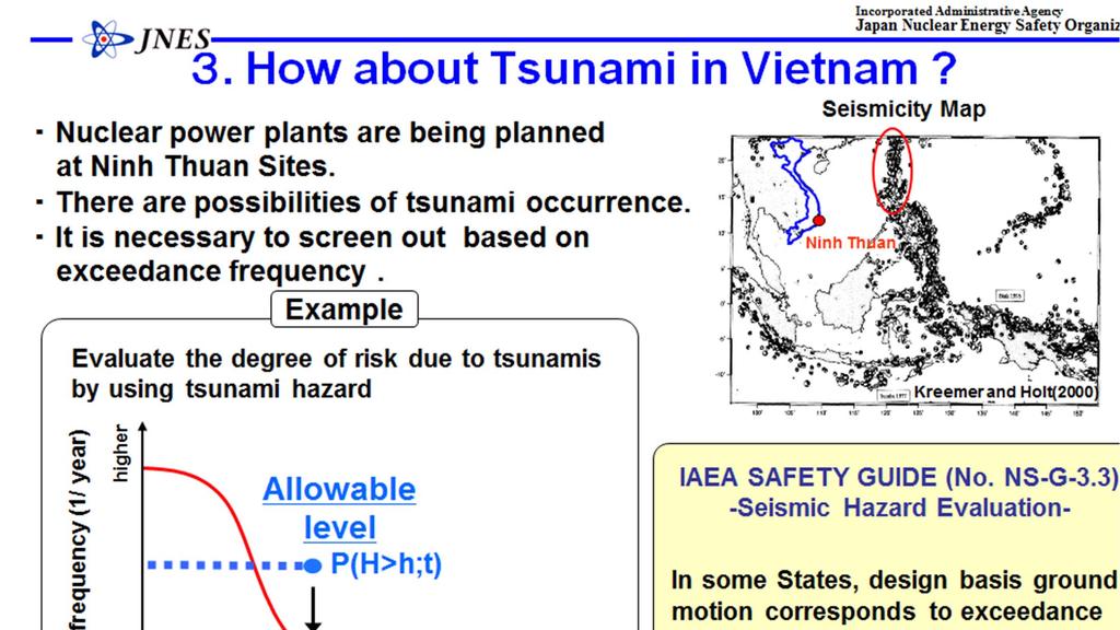
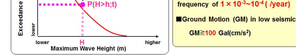
2 Contents 1. Outline of IAEA Tsunami EBP 2. Detail of Contributions 3. How about Tsunami at Vietnam 4. Summary 2
 Act.")

3 I. Introduction IAEA Tsunami EBP and contribution by JNES IAEA Target : IAEA member states, especially Asian regions Act.1 : Disaster mitigation of nuclear facilities and neighboring regions using the information system (TiPEEZ) Act.2 : Diffusion of the assessment method of tsunami hazard for NPPs Implementation term : from Apr 2007 to Mar 2010 JNES Provision and operations support of the TiPEEZ and tsunami analysis codes developed by JNES. IAEA Egypt Turkey Korea Pakistan India Japan USA : Participants of Act.1 : Participants of Act.2 Indonesia Damage of Sumatra tsunami Fig. Participants of Tsunami EBP 3
4 2. Detail of Contributions Base item (A-1) Provision of Codes & Manuals (A-2) Implementation of Training Seminar (A-3) Co-operative work with Participants transferred codes 4
5 (A-1) Provision of Codes & Manuals Incorporated Administrative Agency JNES provided to IAEA the tsunami analysis package in order to share tsunami analysis technology among the Member States of IAEA. This package consists of two codes, manuals and sources 1. Tsunami simulation code TSUNAMI 2. Bathymetry mesh generation code TSUNAMI-Mesh 5
6 (A-1) Provision of Codes & Manuals cont. Manual of TSUNAMI code Table of Contents 1. Methods of Numerical Simulation of Tsunami 2. Program Manual for Far-Field Tsunami Analysis Code 3. Program Manual for Near-Field Tsunami Analysis Code 4. User s Manual for Far-Field Tsunami Analysis Code 5. User s Manual for Near-Field Tsunami Analysis Code 6. Examples of Numerical Simulation of Tsunami 7. Copyright and Immunity 8. Acknowledgement 6
7 (A-1) Provision of Codes & Manuals cont. Manual of TSUNAMI-Mesh code Table of Contents 1. Preface 2. Installation and uninstallation 3. Hardware Requirements 4. Operation Flow 5. Software Structure 6. Open/Rendering Geographic Data 7. Coordinate System 8. Mesh Generation 9. Assignment of the Water Depth to the mesh 10. Faulting 11. Exporting Files 12. Example 13. Copyright and Immunity 7
8 (A-1) Provision of Codes & Manuals cont. Tsunami analysis tech. is transferred assuming users not familiar with tsunami analysis. As a user friendly package with all items shown in the flowchart below. Flowchart of the tsunami analysis (a) Preparation of topography data (b) Topography modeling (c) Tsunami source modeling (d) Numerical simulation 8
 Preparation of topography data ETOPO2 is prepared as default data of sea-depth and land level.")
9 (A-1) Provision of Codes & Manuals cont. (a) Preparation of topography data ETOPO2 is prepared as default data of sea-depth and land level. ETOPO2 is the data around the world developed by NOAA. 9
 Topography modeling TSUNAMI-Mesh is the GUI tool for mesh data generation of")

10 (A-1) Provision of Codes & Manuals cont. (b) Topography modeling TSUNAMI-Mesh is the GUI tool for mesh data generation of tsunami analysis code TSUNAMI developed by JNES. Usable data on TSUNAMI-Mesh is users proprietary topo. data. Selection of ana. region TSUNAMI-Mesh code Nested Grid and bathymetry allocation Fault model setup 10
 Tsunami source modeling TSUNAMI code is a wave")


11 (A-1) Provision of Codes & Manuals cont. (c) Tsunami source modeling TSUNAMI code is a wave propagation analysis code with GUI. Main function: Tsunami source modeling using Manshinha - Smylie (1971) method Far-field analysis with linear model Near-field analysis with linear and nonlinear model Run-up analysis Fault model TSUNAMI code Initial tsunami source North 11

 method Far-field analysis with linear model Near-field")

12 (A-1) Provision of Codes & Manuals last (d) Numerical simulation TSUNAMI code is a wave propagation analysis code with GUI. Main function: Tsunami source modeling using Manshinha - Smylie (1971) method Far-field analysis with linear model Near-field analysis with linear and nonlinear model Run-up analysis TSUNAMI code Far-field analysis Near-field analysis Run-up analysis Japan Chile tsunami 12


13 (A-2) Implementation of training seminar JNES supported two training seminars. 1 st Training Seminar in Korea (25-26 June 2008) Operational training of TSUNAMI & TSUNAMI-Mesh Sample analysis in Users Manual (2004 Indian Ocean Tsunami) Dispatch of Code experts 13
")

14 (A-2) Implementation of training seminar cont. 2 nd Training Seminar in Turkey (25-27 March 2009) Suggestion of the participants work Benchmark analysis Site specific analysis in each countries Dispatch of Code experts 14
 & JNES Target : 2004 Indian Ocean Tsunami, Kalpakkam site Bathymetry Data : ETOPO2, GEBCO, Proprietary data Analysis : Far-field and Near-field, Run-up Mesh size : 5 min. or 6 min.")
15 (A-3) Co-operative work with Participants transferred codes cont. AERB (India) & JNES Target : 2004 Indian Ocean Tsunami, Kalpakkam site Bathymetry Data : ETOPO2, GEBCO, Proprietary data Analysis : Far-field and Near-field, Run-up Mesh size : 5 min. or 6 min. (Far-field) 1350m ~ 50m (Near-field) AERB could use not only default but also Indian coast proprietary topo. data. Near-field TSUNAMI code was update through this work Analysis domain of far-field 15
 & JNES Target : 1983 Akita Tsunami, Ulchin site (Nihonkai Chubu Earthquake Tsunami) Bathymetry Data : ETOPO2, Proprietary data Analysis : Far-field and Near-field, Run-up Mesh size : 2")
16 (A-3) Co-operative work with Participants transferred codes cont. KEPRI (Korea) & JNES Target : 1983 Akita Tsunami, Ulchin site (Nihonkai Chubu Earthquake Tsunami) Bathymetry Data : ETOPO2, Proprietary data Analysis : Far-field and Near-field, Run-up Mesh size : 2 min (Far-field) 1100m ~ 4.6m (Near-field) KEPRI could use Korean coast proprietary topo. data. KEPRI could improve TSUNAMI source code in order to link with their familiar visualization code. New knowledge about the eddy viscosity was got through this work. Analysis domain of far-field 16
17 17


18 Tsunami Source Modeling Incorporated Administrative Agency Tsunami Analysis for Vietnam NPP Topography Modeling Open Topography Data (ETOPO2) Mesh Generator Code Manshinha and Smylie(1971) mgg/fliers/01mgg04.html Tsunami Analysis Tsunami Analysis Code JNES provided Tsunami code to IAEA EBP project. If VARANS and VAEC join the project, they can get the data and codes. We recommend you to join IAEA New EBP and try Tsunami Analysis. 18


19 JNES had already NUCLEAR SAFETY SEMINAR at VIETNAM, March 2009 JNES hope meeting again in order to discuss NPP safety sitting 19
20 JNES Achievements 6. Summary Act.2 on IAEA Tsunami EBP had be implemented to share among MS tsunami analysis tech. and knowledge in relation to tsunami hazard assessment for nuclear power plant. In this EBP, JNES had aimed at helpful contributions based on the cooperative work with MS not the one-side contributions. JNES achieved our (A-1~3) agreements at Kick-off meeting and supported (B) benchmark analysis. (A-1) Provision of Codes & Manuals (A-2) Implementation of Training Seminar (A-3) Co-operative work with Participants transferred codes (B) Benchmark analysis JNES hope These transferred codes will take root at Member States of IAEA. These transferred codes will be used for the tsunami hazard assessment of nuclear power plants in future activities of IAEA or Member States. 20
21 Thank you for your attention! 21
22 (A-2) Implementation of training seminar last Countries transferred Tsunami Analysis Tech. Country Institution Case study at: India Atomic Energy Regulatory Board (AERB) Kalpakkam Kudankulam Indonesia National Nuclear Energy Agency (BATAN) Muria (planning) Korea Korea Power Engineering Co. (KOPEC) Korea Electric Power Research Institute (KEPRI) Ulchin Pakistan Pakistan Atomic Energy Commission (PAEC) Karachi Turkey Middle East Technical Univ. (METU/TAEK) - USA U. S. Nuclear Regulatory Commission (NRC) - 7 institutions in 6 countries 22


23 (A-3) Co-operative work with Participants transferred codes JNES supported analysis of site specific condition by each participants. Q & A Support Suggestion of topography and bathymetry modeling (Location of nesting area, mesh size ) Improvement of transferred code based on these work Doc. of attention for making topo. and bath. model Doc. of suggestion for analysis of India Doc. of suggestion for analysis of Korea 23
 Implementation problem Benchmark Test for #2")
24 Additional support (B) Benchmark analysis Background & Objective Dr. Yalciner suggested benchmark analysis at 1 st StC on EBP To help the participants understanding tsunami analysis technology as code provider (JNES) Implementation problem Benchmark Test for #2 Tsunami run-up onto a complex 3D beach Benchmark Test for #6 Propagation, amplification and reflection of a sample tsunami in a simplified bathymetry 24
 Support of input data conversion Provision of analysis results (Document and animation) Example of Benchmark test #2 Analysis Condition Time")
25 (B) Benchmark analysis cont. Contribution as code provider (JNES) Support of input data conversion Provision of analysis results (Document and animation) Example of Benchmark test #2 Analysis Condition Time history of wave height at G3 point Input Wave G3 G2 G1 Wave Height (m) Experimental Numerical Numerical Time (s) 25
SMR/ May Simulation Analyses of Tsunami caused by Chilean and Nihon-Kai Chubu Earthquakes at Nuclear Power Plant Sites in Japan
 SMR/1839-2 Workshop on the Physics of Tsunami, Hazard Assessment Methods and Disaster Risk Management (Theories and Practices for Implementing Proactive Countermeasures) 14-18 May 2007 Simulation Analyses
Training System and Information Network for Earthquake Disaster Mitigation. Taiki SAITO. Building Research Institute (BRI)
") 1 Training System and Information Network for Earthquake Disaster Mitigation Taiki SAITO Chief Research Engineer, International Institute of Seismology and Earthquake Engineering (IISEE), Building Research
1 Training System and Information Network for Earthquake Disaster Mitigation Taiki SAITO Chief Research Engineer, International Institute of Seismology and Earthquake Engineering (IISEE), Building Research
Actual practices of seismic strong motion estimation at NPP sites
 ANSN Regional Workshop on Site Selection and Evaluation for Nuclear Power Plants June 2010, Hanoi Vietnam IAEA/ISSC Actual practices of seismic strong motion estimation at NPP sites Yoshi. FUKUSHIMA (JNES)
Training System and Information Network for Earthquake Disaster Mitigation. Taiki SAITO. Building Research Institute (BRI)
") Asian Science and Technology Forum Tsukuba Seminar, 2007.10.03, Tsukuba Training System and Information Network for Earthquake Disaster Mitigation Taiki SAITO Chief Research Engineer, International Institute
Asian Science and Technology Forum Tsukuba Seminar, 2007.10.03, Tsukuba Training System and Information Network for Earthquake Disaster Mitigation Taiki SAITO Chief Research Engineer, International Institute
COMPARE OF THE EMPIRICAL AND NUMERICAL TSUNAMI HAZARD ASSESSMENT RESULTS FOR THE EAST COAST OF KOREA. Min Kyu Kim 1, In-kil Choi 2
 COMPARE OF THE EMPIRICAL AND NUMERICAL TSUNAMI HAZARD ASSESSMENT RESULTS FOR THE EAST COAST OF KOREA Min Kyu Kim 1, In-kil Choi 2 1 Korea Atomic Energy Research Institute: 989-111 Daedeok-Daero Youseong
History of International Training in Seismology and Earthquake Engineering at IISEE
 History of International Training in Seismology and Earthquake Engineering at IISEE Activities of International Institute of Seismology and Earthquake Engineering (IISEE), BRI - Training for young researchers/engineers
Report of PCGIAP to the 18 th United Nations Regional Cartographic Conference for Asia and the Pacific (UNRCC-AP) for the period
 for the period") Permanent Committee on GIS Infrastructure for Asia and the Pacific (PCGIAP) Established in 1995 by a United Nations Resolution Report of PCGIAP to the 18 th United Nations Regional Cartographic Conference
Permanent Committee on GIS Infrastructure for Asia and the Pacific (PCGIAP) Established in 1995 by a United Nations Resolution Report of PCGIAP to the 18 th United Nations Regional Cartographic Conference
Updating the GEBCO Grid
 Updating the GEBCO Grid PAULINE WEATHERALL, GEBCO DIGITAL ATLAS MANAGER, BRITISH OCEANOGRAPHIC DATA CENTRE (BODC), NATIONAL OCEANOGRAPHY CENTRE (NOC), LIVERPOOL, UK. GEBCO TSCOM and SCRUM meeting, Kuala
DATA BASE DEVELOPMENT OF ETA (ESTIMATED TIME OF ARRIVAL) FOR TSUNAMI DISASTER MITIGATION AT SOUTHWESTERN CITIES OF ACEH, INDONESIA
 FOR TSUNAMI DISASTER MITIGATION AT SOUTHWESTERN CITIES OF ACEH, INDONESIA") 6 th South China Sea Tsunami Workshop Nanyang Technology University, Singapore, 6-8 November 2013 DATA BASE DEVELOPMENT OF ETA (ESTIMATED TIME OF ARRIVAL) FOR TSUNAMI DISASTER MITIGATION AT SOUTHWESTERN
6 th South China Sea Tsunami Workshop Nanyang Technology University, Singapore, 6-8 November 2013 DATA BASE DEVELOPMENT OF ETA (ESTIMATED TIME OF ARRIVAL) FOR TSUNAMI DISASTER MITIGATION AT SOUTHWESTERN
JCOMM-CHy Coastal Inundation Forecasting Demonstration Project (CIFDP)
") WMO World Meteorological Organization Working together in weather, climate and water JCOMM-CHy Coastal Inundation Forecasting Demonstration Project (CIFDP) Coastal Flooding & Vulnerable Populations Coastal
WMO World Meteorological Organization Working together in weather, climate and water JCOMM-CHy Coastal Inundation Forecasting Demonstration Project (CIFDP) Coastal Flooding & Vulnerable Populations Coastal
Advisors: Arcadii Grinshpan, Mathematics and Statistics Rocco Malservisi, School of Geosciences. Problem Suggested By: Rocco Malservisi
 Undergraduate Journal of Mathematical Modeling: One + Two Volume 8 2018 Spring 2018 Issue 2 Article 6 Tsunami Waves Samantha Pennino University of South Florida Advisors: Arcadii Grinshpan, Mathematics
Outline of Guideline for Development and Utilization of Tsunami Disaster Management Map
 Outline of Guideline for Development and Utilization of Tsunami Disaster Management Map Port and Airport Research Institute, Japan The Overseas Coastal Area Development Institute of Japan Ports and Harbours
Numerical simulations for Investigation of the Coastline Erosion due to the 2004 Indian Ocean Tsunami
 Numerical simulations for Investigation of the Coastline Erosion due to the 2004 Indian Ocean Tsunami Syamsidik, Musa Al ala, Mirza Fahmi, and Tursina Tsunami Computation and Visualization Laboratory Tsunami
NUMERICAL SIMULATION AS GUIDANCE IN MAKING TSUNAMI HAZARD MAP FOR LABUAN ISLAND
 NUMERICAL SIMULATION AS GUIDANCE IN MAKING TSUNAMI HAZARD MAP FOR LABUAN ISLAND MOHD RIDZUAN bin Adam Supervisor: Fumihiko IMAMURA MEE09199 ABSTRACT At the northeast end of the South China Sea, tsunamis
The ITSU System in the Pacific Region and Future Upgrades
 The ITSU System in the Pacific Region and Future Upgrades Eddie Bernard Director, Pacific Marine Environmental Laboratory (PMEL) NOAA/USA Pacific Tsunami Warning Center OPERATIONAL ACTIVITIES SEISMIC DATA
Revision of the AESJ Standard for Seismic Probabilistic Risk Assessment (2) Seismic Hazard Evaluation
 Seismic Hazard Evaluation") Revision of the AESJ Standard for Seismic Probabilistic Risk Assessment (2) Seismic Hazard Evaluation Katsumi Ebisawa a, Katsuhiro Kamae b, Tadashi Annaka c, Hideaki Tsutsumi d And Atsushi Onouchi e a
Revision of the AESJ Standard for Seismic Probabilistic Risk Assessment (2) Seismic Hazard Evaluation Katsumi Ebisawa a, Katsuhiro Kamae b, Tadashi Annaka c, Hideaki Tsutsumi d And Atsushi Onouchi e a
Utilization and Provision of Geographical Name Information on the Basic Map of Japan*
 UNITED NATIONS WORKING PAPER GROUP OF EXPERTS NO. 1/9 ON GEOGRAPHICAL NAMES Twenty-eight session 28 April 2 May 2014 Item 9 of the Provisional Agenda Activities relating to the Working Group on Toponymic
Indian Ocean Tsunami Warning System: Example from the 12 th September 2007 Tsunami
 Indian Ocean Tsunami Warning System: Example from the 12 th September 2007 Tsunami Charitha Pattiaratchi 1 Professor of Coastal Oceanography, The University of Western Australia Email: chari.pattiaratchi@uwa.edu.au
PoS(ISGC 2011 & OGF 31)078
078") Modeling scenarios of earthquake-generated tsunamis for Vietnam coasts Davide Bisignano Università degli Studi di Trieste, Department of Geosciences Via E. Weiss 4, Trieste, Italy E-mail: davide.bisignano@gmail.com
Modeling scenarios of earthquake-generated tsunamis for Vietnam coasts Davide Bisignano Università degli Studi di Trieste, Department of Geosciences Via E. Weiss 4, Trieste, Italy E-mail: davide.bisignano@gmail.com
Overview of Consequences of the Tsunami in Thailand and Roles and Activities of the Department of Mineral Resources after the 26 December 2004 Tsunami
 Overview of Consequences of the Tsunami in Thailand and Roles and Activities of the after the 26 December 2004 Tsunami By Mr.Worawoot Tantiwanit, Thailand 1 Earthquake in NW of North Sumatra Island 580
Checking of Seismic and Tsunami Hazard for Coastal NPP of Chinese Continent
 Checking of Seismic and Tsunami Hazard for Coastal NPP of Chinese Continent Chang Xiangdong (Nuclear and Radiation Safety Center, MEP, China) 2012.Sep 1. Introduction After Japanese Fukushima nuclear accident
Probable Maximum Tsunami due to an Earthquake in the Makran Subduction Zone
 Probable Maximum Tsunami due to an Earthquake in the Makran Subduction Zone Ahmed Jemie Dababneh, Ph.D., P.E., Benjamin Ferguson, P.E. and, Daniel J. Barton, P.E. Paul C. Rizzo Associates, Inc. Pittsburgh,
Tectonic Hazard Evaluations for Korean Nuclear Sites
 Tectonic Hazard Evaluations for Korean Nuclear Sites June 13-17, 2011 Jakarta, INDONESIA Hyunwoo LEE (heanu@kins.re.kr) Korea Institute of Nuclear Safety 1 2 3 4 5 Introduction Tectonic Environment of
International Research Collaboration in Indonesia: LIPI as a special reference
 Workshop on Science & Technology Cooperation With Developing Countries on Global Issues. Tokyo, 8 October 2008 International Research Collaboration in Indonesia: LIPI as a special reference Hery Harjono
Global Map: A Tool for Disaster Mitigation for the Asia and Pacific Region
 Global Map: A Tool for Disaster Mitigation for the Asia and Pacific Region D. R. Fraser Taylor Chair, International Steering Committee for Global Mapping (ISCGM) fraser_taylor@carleton.ca www. 18 th United
Coastal Inundation Forecasting Demonstration Project (CIFDP)
") WMO World Meteorological Organization Working together in weather, climate and water Coastal Inundation Forecasting Demonstration Project (CIFDP) WMO Technical Commission for Oceanography and Marine Meteorology
WMO World Meteorological Organization Working together in weather, climate and water Coastal Inundation Forecasting Demonstration Project (CIFDP) WMO Technical Commission for Oceanography and Marine Meteorology
Uniform Hazard Spectrum(UHS) for performance based seismic design
 for performance based seismic design") Uniform Hazard Spectrum(UHS) for performance based seismic design *Jun-Kyoung Kim 1), Soung-Hoon Wee 2) and Seong-Hwa Yoo 2) 1) Department of Fire Protection and Disaster Prevention, Semyoung University,
Uniform Hazard Spectrum(UHS) for performance based seismic design *Jun-Kyoung Kim 1), Soung-Hoon Wee 2) and Seong-Hwa Yoo 2) 1) Department of Fire Protection and Disaster Prevention, Semyoung University,
Analysis of Tsunami Resonance and Impact in Coastal Waters
 Journal of Navigation and Port Research International Edition Vol.35, No.9 pp. 755~763, 2011 (ISSN-1598-5725) DOI : http://dx.doi.org/10.5394/kinpr.2011.35.9.755 Analysis of Tsunami Resonance and Impact
The IISEE earthquake catalog, Catalog of Damaging Earthquakes in the World, IISEE-NET,, and BRI strong motion observation
 The IISEE earthquake catalog, Catalog of Damaging Earthquakes in the World, IISEE-NET,, and BRI strong motion observation Tatsuhiko Hara International Institute of Seismology and Earthquake Engineering,
Probabilistic Seismic Hazard Analysis Using Physical Constraints
 Probabilistic Seismic Hazard Analysis Using Physical Constraints NEA Workshop, Tsukuba, Japan, 15 17 November 2004 A. Gürpinar, International Atomic Energy Agency Contents of the Presentation Introduction
GENERAL. CHAPTER 1 BACKGROUND AND PURPOSE OF THE GUIDELINES Background of the Guidelines Purpose of the Guidelines...
 GENERAL CHAPTER 1 BACKGROUND AND PURPOSE OF THE GUIDELINES... 1 1.1 Background of the Guidelines... 1 1.2 Purpose of the Guidelines... 3 CHAPTER 2 APPLICATION OF THE GUIDELINES... 3 2.1 Potential Users
STUDY ON APPROPRIATE MODELING OF TSUNAMIS IN MALAYSIA FOR RISK EVALUATION
 STUDY ON APPROPRIATE MODELING OF TSUNAMIS IN MALAYSIA FOR RISK EVALUATION Zaty Aktar binti Mokhtar* Supervisor: Fumihiko Imamura** MEE06025 Shunichi Koshimura** ABSTRACT In order to design a tsunami warning
Effect of the Emperor seamounts on trans-oceanic propagation of the 2006 Kuril Island earthquake tsunami
 GEOPHYSICAL RESEARCH LETTERS, VOL. 35, L02611, doi:10.1029/2007gl032129, 2008 Effect of the Emperor seamounts on trans-oceanic propagation of the 2006 Kuril Island earthquake tsunami S. Koshimura, 1 Y.
Report for 15th PCGIAP Meeting at 18th UNRCC-AP Working Group 1 Regional Geodesy
 Report for 15th PCGIAP Meeting at 18th UNRCC-AP Working Group 1 Regional Geodesy Chairman Shigeru Matsuzaka, Japan - shigeru@gsi.go.jp Vice Chairman Prof. Pengfei Cheng, China - chengpf@casm.ac.cn John
NGIAs' roles in successful disaster response
 The Second UN-GGIM-AP Plenary Meeting NGIAs' roles in successful disaster response Japan Teheran Iran 28 October 2013 Shin-ichi SAKABE, Director of International Affairs Division Geospatial Information
Developing fragility functions for tsunami damage estimation using the numerical model and satellite imagery
 Developing fragility functions for tsunami damage estimation using the numerical model and satellite imagery Shunichi KOSHIMURA 1 and Hideaki YANAGISAWA 2 1 Associate Professor, Disaster Control Research
Meeting July 2018 Agenda Item 7.1. Tsunami Service Provider Messages for the Maritime Community. Submitted by IOC Secretariat SUMMARY
 WWNWS WWNWS10/7/1 Meeting 10 19 July 2018 Agenda Item 7.1 Tsunami Service Provider Messages for the Maritime Community Submitted by IOC Secretariat SUMMARY Executive Summary: This document provides details
Wainui Beach Management Strategy (WBMS) Summary of Existing Documents. GNS Tsunami Reports
 Summary of Existing Documents. GNS Tsunami Reports") Wainui Beach Management Strategy (WBMS) Summary of Existing Documents GNS Tsunami Reports a) Review of Tsunami Hazard and Risk in New Zealand ( National Risk Report ) b) Review of New Zealand s Preparedness
Wainui Beach Management Strategy (WBMS) Summary of Existing Documents GNS Tsunami Reports a) Review of Tsunami Hazard and Risk in New Zealand ( National Risk Report ) b) Review of New Zealand s Preparedness
Geographic Information Systems(GIS)
") Geographic Information Systems(GIS) Threat Analysis Techniques Overview What is GIS? Functional capabilities of GIS BCM Process and GIS How to leverage GIS in threat/risk analysis Ron Brown, CBCP Managing
Geographic Information Systems(GIS) Threat Analysis Techniques Overview What is GIS? Functional capabilities of GIS BCM Process and GIS How to leverage GIS in threat/risk analysis Ron Brown, CBCP Managing
Word Cards. 2 map. 1 geographic representation. a description or portrayal of the Earth or parts of the Earth. a visual representation of an area
 Name: Date: Hour: Word Cards 1 geographic representation a description or portrayal of the Earth or parts of the Earth Example: A map is a representation of an actual location or place. 2 map a visual
KARI Activation for the International Disasters
 KARI Activation for the International Disasters 5 th Joint Project Team Meeting for Sentinel Asia STEP2 (JPTM2012) 14 th Nov 2012 Boyeol Yoon Senior Researcher, Satellite Information Research Center (SIRC)
GUIDELINES FOR CONSTRUCTION TECHNOLOGY TRANSFER DEVELOPMENT OF WARNING AND EVACUATION SYSTEM AGAINST SEDIMENT DISASTERS IN DEVELOPING COUNTRIES
 GUIDELINES FOR CONSTRUCTION TECHNOLOGY TRANSFER DEVELOPMENT OF WARNING AND EVACUATION SYSTEM AGAINST SEDIMENT DISASTERS IN DEVELOPING COUNTRIES MARCH 2004 Ministry of Land, Infrastructure and Transport
Establishment of Abdus Salam Geomagnetic Observatory Sonmiani, Pakistan: Site Selection to INTERMAGNET Certification
 Pakistan Space & Upper Atmosphere Research Commission Establishment of Abdus Salam Geomagnetic Observatory Sonmiani, Pakistan: Site Selection to INTERMAGNET Certification G. Murtaza Space Science Department
Probabilistic Tsunami Hazard Assessment addressing the uncertainty of tsunami source
 Probabilistic Tsunami Hazard Assessment addressing the uncertainty of tsunami source Pacific Rim Forum 2017 January 23, 2017 Yuta Abe, ITOCHU Techno-Solutions Corporation, Japan Copyright (c)2017 ITOCHU
Lessons Learned from Past Tsunamis Warning and Emergency Response
 UNESCO IOC CTIC US NOAA ITIC Regional Training Workshop on Strengthening Tsunami Warning and Emergency Response Standard Operating Procedures and the Development of the ICG/CARIBE-EWS PTWC New Enhanced
Predicting of Tsunami Inundation Area based on Propagation and Runup Numerical Model in Pacitan City
 Predicting of Tsunami Inundation Area based on Propagation and Runup Numerical Model in Pacitan City 1 Agus Suharyanto, 1 Alwafi Pujiraharjo, 2 Adipandang Yudono, 3 Keisuke Murakami, and 3 Chikashi Deguchi
Funded by Japan Government through UN ESCAP and BMKG
 METEOROLOGY & COAST RADIO SERVICES MINISTRY OF METEOROLOGY, ENERGY, INFORMATION,DISASTER MANAGEMENT, ENVIRONMENT, CLIMATE CHANGE AND COMMUNICATION KINGDOM OF TONGA P. O. Box 845, Domestic Terminal, Fua
New Tsunami Disaster Mitigation System considering Local Conditions of Indian Ocean Rim Regions
 New Tsunami Disaster Mitigation System considering Local Conditions of Indian Ocean Rim Regions Kimiro Meguro Professor, Institute of Industrial Science, The University of Tokyo, Japan Shunichi Koshimura
Tsunami Waveform Inversion based on Oceanographic Radar Data
 Research Institute for Applied Mechanics Workshop of Oceanographic Radar 12-13 December 2012 1 Tsunami Waveform Inversion based on Oceanographic Radar Data Ryotaro Fuji 1), Hirofumi Hinata 1), Tomoyuki
IG-WRDRR, UNESCAP, UNESCO-IOC, WMO. Yukio Tamura Chairman, International. Group. Tuesday 10 May, , Room 13. for Disaster. Risk.
 Side Event: Saving of Lives and Improved Coastal Risk Management through Regional Cooperation in Ocean and Marine Related Early Warning Systems in Asia Tuesday 10 May, 13.15 14.15, Room 13 IG-WRDRR, UNESCAP,
WERA Ocean Radar Capability of Real-Time Tsunami Detection
 WERA Ocean Radar Capability of Real-Time Tsunami Detection Dr. Anna Dzvonkovskaya Helzel Messtechnik GmbH Kaltenkirchen, GERMANY e-mail: dzvonkovskaya@helzel.com member of and Worldwide WERA HF Ocean Radar
Tsunami Risk Mitigation Strategy for Thailand. Kjell Karlsrud Norwegian Geotechnical Institute (NGI)
") Tsunami Risk Mitigation Strategy for Thailand Kjell Karlsrud Norwegian Geotechnical Institute (NGI) The project was undertaken by NGI in cooperation with: NORSAR, UiB, UiO, NIBR, B.Heyerdahl, NTNU, Sintef
Tsunami Risk Mitigation Strategy for Thailand Kjell Karlsrud Norwegian Geotechnical Institute (NGI) The project was undertaken by NGI in cooperation with: NORSAR, UiB, UiO, NIBR, B.Heyerdahl, NTNU, Sintef
Progress Report. Flood Hazard Mapping in Thailand
 Progress Report Flood Hazard Mapping in Thailand Prepared By: Mr. PAITOON NAKTAE Chief of Safety Standard sub-beuro Disaster Prevention beuro Department of Disaster Prevention and Mitigation THAILAND E-mail:
Status after Six Years
 German-Indonesian Tsunami Early Warning System () Status after Six Years Joern Lauterjung and the -Team Challenge Indonesia Short Early Warning Time Tsunamis are generated at the trench (orange line) Traveltimes
Baldwin County, Alabama
 2015 Baldwin County, Alabama Multi-Hazard Mitigation Plan I. Comprehensive Plan A multi-jurisdiction plan City of Bay Minette City of Daphne Town of Elberta City of Fairhope City of Foley City of Gulf
What is PRECIS and what can it do?
 PRECIS: Facilitating capacity building and technology transfer to enable climate change mitigation and adaptation activities worldwide Joseph Intsiful, UNFCCC NWP Meeting, Mexico City 4-7 March 2008 Content:
caused displacement of ocean water resulting in a massive tsunami. II. Purpose
 I. Introduction The Great Sumatra Earthquake event took place on December 26, 2004, and was one of the most notable and devastating natural disasters of the decade. The event consisted of a major initial
Mechanism of tsunami generation,propagation and runup -sharing experiences with Japanese
 Mechanism of tsunami generation,propagation and runup -sharing experiences with Japanese Mechanism of tsunami generation Predicting the propagation, runup and inundation of tsunamis Near and far-field
Earthquake Hazards. Tsunami
 Earthquake Hazards Tsunami Measuring Earthquakes Two measurements that describe the power or strength of an earthquake are: Intensity a measure of the degree of earthquake shaking at a given locale based
Earthquake Hazards. Tsunami
 Earthquake Hazards Tsunami Review: What is an earthquake? Earthquake is the vibration (shaking) and/or displacement of the ground produced by the sudden release of energy. The point inside the Earth where
METEOROLOGICAL WARNINGS STUDY GROUP (METWSG)
") METWSG/4-SN No. 6 12/3/12 METEOROLOGICAL WARNINGS STUDY GROUP (METWSG) FOURTH MEETING Montréal, 15 to 18 May 2012 Agenda Item 6: Wind shear, turbulence and tsunami warnings TSUNAMI INFORMATION (Presented
METWSG/4-SN No. 6 12/3/12 METEOROLOGICAL WARNINGS STUDY GROUP (METWSG) FOURTH MEETING Montréal, 15 to 18 May 2012 Agenda Item 6: Wind shear, turbulence and tsunami warnings TSUNAMI INFORMATION (Presented
Fukushima: What don't we know?
 Fukushima: What don't we know? BY RODNEY C. EWING AND JEROEN RITSEMA 3 MAY 2011 On March 11, when news of the terrible events at the Fukushima Daiichi nuclear power plant began to emerge, so did the contrasts:
"The Natural Disasters, like The Sumatra Tsunami had taught us before -BUT" U Than Myint President Myanmar Engineering Society
 "The Natural Disasters, like The Sumatra Tsunami had taught us before -BUT" U Than Myint President Myanmar Engineering Society Present Day Regional Tectonic Setting of South East Asia Tsunami-generated
Mainstream Space Technology in Implementing SFDRR - GPSTAR. Srimal Samansiri Disaster Management Centre Government of Sri Lanka
 Mainstream Space Technology in Implementing SFDRR - GPSTAR Srimal Samansiri Disaster Management Centre Government of Sri Lanka SFDRR Priority Actions Effective use of Space technology in SFDRR Priority
Seismic Activity and Crustal Deformation after the 2011 Off the Pacific Coast of Tohoku Earthquake
 J-RAPID Symposium March 6-7, 2013 Seismic Activity and Crustal Deformation after the 2011 Off the Pacific Coast of Tohoku Earthquake Y. Honkura Tokyo Institute of Technology Japan Science and Technology
Annual Report for Research Work in the fiscal year 2005
 JST Basic Research Programs C R E S T (Core Research for Evolutional Science and Technology) Annual Report for Research Work in the fiscal year 2005 Research Area : High Performance Computing for Multi-scale
Tokyo Climate Center s activities as RCC Tokyo
 First WMO Workshop on Operational Climate Prediction Pune, India, 09-11 November 2015 Tokyo Climate Center s activities as RCC Tokyo Arata Endo Tokyo Climate Center Japan Meteorological Agency E-mail:
Application of a GIS for Earthquake Hazard Assessment and Risk Mitigation in Vietnam
 Application of a GIS for Earthquake Hazard Assessment and Risk Mitigation in Vietnam Nguyen Hong Phuong Earthquake Information and Tsunami Warning Centre, VAST OUTLINE Introduction Fault Source Model and
Coupling of Wave and Hydrodynamic Models for Predicting Coastal Inundation: A case study in Jakarta and Semarang
 Coupling of Wave and Hydrodynamic Models for Predicting Coastal Inundation: A case study in Jakarta and Semarang http://peta-maritim.bmkg.go.id/cifdp/maps Nelly Florida Riama,Andri Ramdhani, Andi Eka Sakya,,
NUMERICAL SIMULATION OF TSUNAMI PROPAGATION AND INUNDATION ALONG THE RAKHINE COAST AREAS IN MYANMAR
 NUMERICAL SIMULATION OF TSUNAMI PROPAGATION AND INUNDATION ALONG THE RAKHINE COAST AREAS IN MYANMAR Su Hninn Htwe Supervisor: Bunichiro SHIBAZAKI MEE12619 Yushiro FUJII ABSTRACT This study aimed to assess
Fukushima nuclear power plant damaged by M9 Earthquake with some focus on ocean
 Fukushima nuclear power plant damaged by M9 Earthquake with some focus on ocean Moto Ikeda (Hokkaido Univ. & JAMSTEC) Oceanographic Society of Japan, Earthquake Disaster Working Group Magnitude-9 earthquake
Capacity Building in Applications of Remote Sensing and GIS for Disaster Management
 Capacity Building in Applications of Remote Sensing and GIS for Disaster Management M.K. Hazarika, L. Samarakoon, N. Senevirathne, J.S.M. Fowze and R. de Silva Project Researcher GeoInformatics Center
KNOWLEDGE NOTE 5-1. Risk Assessment and Hazard Mapping. CLUSTER 5: Hazard and Risk Information and Decision Making. Public Disclosure Authorized
 Public Disclosure Authorized Public Disclosure Authorized Public Disclosure Authorized Public Disclosure Authorized KNOWLEDGE NOTE 5-1 CLUSTER 5: Hazard and Risk Information and Decision Making Risk Assessment
South Asian Climate Outlook Forum (SASCOF-6)
") Sixth Session of South Asian Climate Outlook Forum (SASCOF-6) Dhaka, Bangladesh, 19-22 April 2015 Consensus Statement Summary Below normal rainfall is most likely during the 2015 southwest monsoon season
Sixth Session of South Asian Climate Outlook Forum (SASCOF-6) Dhaka, Bangladesh, 19-22 April 2015 Consensus Statement Summary Below normal rainfall is most likely during the 2015 southwest monsoon season
Cooperating Country Report of GERMANY
 CCOP-47AS/4.1-19 COORDINATING COMMITTEE FOR GEOSCIENCE PROGRAMMES IN EAST AND SOUTHEAST ASIA (CCOP) 47 th CCOP Annual Session 17-21 October 2010 Manado, Indonesia Cooperating Country Report of GERMANY
"The Big One" by sea and not by land
 "The Big One" by sea and not by land By Los Angeles Times, adapted by Newsela staff on 03.24.14 Word Count 629 Surfer Lee Johnson emerges from the water at San Onofre State Beach, Calif., with the twin
Earthquakes. Earthquake Magnitudes 10/1/2013. Environmental Geology Chapter 8 Earthquakes and Related Phenomena
 Environmental Geology Chapter 8 Earthquakes and Related Phenomena Fall 2013 Northridge 1994 Kobe 1995 Mexico City 1985 China 2008 Earthquakes Earthquake Magnitudes Earthquake Magnitudes Richter Magnitude
Sentinel Asia Tsunami Working Group
 Sentinel Asia Tsunami Working Group Co-Chairman: Prof. Shunichi Koshimura Abdul Muhari, PhD 4 th Joint Project Team Meeting (JPTM 2017): Sentinel Asia STEP 3 Abdul MUHARI, PhD Ministry of Marine Affairs
Tsunami Inundation Modeling in the Aegean Sea
 Tsunami Inundation Modeling in the Aegean Sea B. Aydın Akdeniz University, Antalya, Turkey O. Hoto & U. Kânoğlu Middle East Technical University, Ankara, Turkey SUMMARY: The tsunami forecasting system
MODELLING CATASTROPHIC COASTAL FLOOD RISKS AROUND THE WORLD
 MODELLING CATASTROPHIC COASTAL FLOOD RISKS AROUND THE WORLD Nicola Howe Christopher Thomas Copyright 2016 Risk Management Solutions, Inc. All Rights Reserved. June 27, 2016 1 OUTLINE MOTIVATION What we
Riskscape module Documentation: Inundation Modelling in Bay of Plenty. X. Wang C. Mueller
 Riskscape module Documentation: Inundation Modelling in Bay of Plenty X. Wang C. Mueller CONTENTS 1.0 GENERAL INFORMATION... 2 1.1 SITE OF STUDY... 5 1.2 SOURCE SCENARIOS... 5 1.3 NUMERICAL MODEL... 5
Development of Global Map for GEOSS SBAs US-09-03a
 Development of Global Map for GEOSS SBAs US-09-03a UIC User Engagement Session 2 November, 2010 Yoshikazu FUKUSHIMA Secretariat General of International Steering Committee for Global Mapping Geospatial
Disaster Mitigation Competence Centre Project Meeting Coordinator: Simon Lin
 Disaster Mitigation Competence Centre Project Meeting Coordinator: Simon Lin April 26, 2018 Agenda Introduction (Simon Lin) From Previous Meeting on March 17, 2015 (Eric Yen) Progress Report (Eric Yen)
Study on a Simplified Method of Tsunami Risk Assessment
 Natural Hazards 29: 325 340, 2003. 2003 Kluwer Academic Publishers. Printed in the Netherlands. 325 Study on a Simplified Method of Tsunami Risk Assessment HIROAKI SATO River and Coastal Engineering Department,
is a unifying theme in modern geology that integrates the earlier ideas of
 The concept of Global Plate Tectonics is a unifying theme in modern geology that integrates the earlier ideas of continental drift, sea-floor spread, and mountain building To explain why the present ocean
Response characteristics of R/C buildings considering impulsive force of tsunami drifting objects
 Response characteristics of R/C buildings considering impulsive force of tsunami drifting objects Ho CHOI 1, Kazuto MATSUKAWA 2 and Yoshiaki NAKANO 3 1 Research Associate, Institute of Industrial Science,
at IHO IRCC7 Mexico City, Mexico, June 2015
 Report on Japan s Response to Disasters presented by JHOD at IHO IRCC7 Mexico City, Mexico, 01 03 June 2015 JAPAN COAST GUARD Actions against huge earthquake Actions taken by JHOD against the Great East
3D Seismic Hazard and Risk Maps for Earthquake Awareness of Citizens with Aids of GIS and Remote Sensing Technologies
 3D Seismic Hazard and Risk Maps for Earthquake Awareness of Citizens with Aids of GIS and Remote Sensing Technologies Saburoh Midorikawa Tokyo Institute of Technology In Japan, seismic hazard and risk
Integrated Hydrodynamic Modeling System
 Integrated Hydrodynamic Modeling System Applied Science Associates, Inc. 70 Dean Knauss Drive Narragansett, RI USA 02882 www.asascience.com support@asascience.com 1 Introduction HYDROMAP is a globally
Current Landscape of Spatial Decision Support Systems (SDSS) and Software Applications for Earthquake Disaster Management in Turkey
 and Software Applications for Earthquake Disaster Management in Turkey") Presented at the FIG Congress 2018, May 6-11, 2018 in Istanbul, Turkey Current Landscape of Spatial Decision Support Systems (SDSS) and Software Applications for Earthquake Disaster Management in Turkey
Presented at the FIG Congress 2018, May 6-11, 2018 in Istanbul, Turkey Current Landscape of Spatial Decision Support Systems (SDSS) and Software Applications for Earthquake Disaster Management in Turkey
Ryuji Yamada Tokyo Climate Center Japan Meteorological Agency E mail: URL:
 Ryuji Yamada Tokyo Center Japan Meteorological Agency E mail: tcc@met.kishou.go.jp URL: http://ds.data.jma.go.jp/tcc/tcc/index.html Tokyo Center (TCC) Established in April 2002 at JMA to support climate
PRECIS: Facilitating capacity building and climate vulnerability studies and applications in Africa
 PRECIS: Facilitating capacity building and climate vulnerability studies and applications in Africa Richard Jones Presentation to Met Africa group, Reading University 15.10.2007 Crown copyright Page 1
RESEARCH PROJECT ON ENHANCEMENT OF TECHNOLOGY TO DEVELOP TSUNAMI- RESILIENT COMMUNITY. Activities Considered in the Chilean Research Groups
 WORKING GROUPS RESEARCH PROJECT ON ENHANCEMENT OF TECHNOLOGY TO DEVELOP TSUNAMI- RESILIENT COMMUNITY Activities Considered in the Chilean Research Groups International Symposium on Earthquake & Tsunami
Impact, diffusion and scaling-up of a comprehensive land use planning approach in the Philippines
 Impact, diffusion and scaling-up of a comprehensive land use planning approach in the Philippines From development cooperation to national policies towards achieving the SDGs International Workshop: Impact
Tsunami hazard risk and early warning projects at Global Geophysics Institute, Vietnam
 Tsunami hazard risk and early warning projects at Global Geophysics Institute, Vietnam presented by Dr Kelvin Berryman, GNS Science, New Zealand k.berryman@gns.cri.nz on behalf of Prof. Bui C. Que,, Director
Visual Notices to mariners & Navigational Warnings
 Visual Notices to mariners & Navigational Warnings 22 MAY, 2017 Hydrographic and Oceanographic Department Talking about: Visual Notices to Mariners & Navigational Warning System Text on a paper Text information
WMO. Early Warning System
 World Meteorological Organization Working together in weather, climate and water WMO Tropical Cyclone Early Warning System Koji Kuroiwa Tropical Cyclone Programme World Meteorological Organization For
Status and Challenges on Geo-DRM Information Systems in Tonga
 Name: Mafua- i-vai utukakau Maka Status and Challenges on Geo-DRM Information Systems in Tonga 1 Roles and Relationships Land and Geographic Information Systems (LGIS) Unit: Establish updated high-resolution
By Geri Flanary To accompany AP Human Geography: A Study Guide 3 rd edition By Ethel Wood
 Session 1 By Geri Flanary To accompany AP Human Geography: A Study Guide 3 rd edition By Ethel Wood WHAT IS DEMOGRAPHY? It is the scientific or statistical study of population. It comes from the Greek
Disaster and Science. Post-Tohoku research actions in France. March 6, 2013
 Disaster and Science Post-Tohoku research actions in France March 6, 2013 Question for the "Disaster and Science" session "HOW SCIENTIFIC COMMUNITY OF HIS/HER COUNTRY HAS REACTED AFTER MARCH 11, 2011 EARTHQUAKE"?