DISTRIBUTION AND CLIMATIC RELATIONSHIPS OF THE AMERICAN PIKA (OCHOTONA PRINCEPS) IN THE SIERRA NEVADA AND WESTERN GREAT BASIN, USA;
|
|
|
- Delilah Flowers
- 6 years ago
- Views:
Transcription
1 Corresponding Author: Dr. Constance I. Millar USDA Forest Service, Sierra Nevada Research Center 00 Buchanan St. W.A.B., Albany, CA USA phone: --; fax: --0 DISTRIBUTION AND CLIMATIC RELATIONSHIPS OF THE AMERICAN PIKA (OCHOTONA PRINCEPS) IN THE SIERRA NEVADA AND WESTERN GREAT BASIN, USA; PERIGLACIAL LANDFORMS AS REFUGIA IN WARMING CLIMATES Constance I. Millar and Robert D. Westfall USDA Forest Service, Pacific Southwest Research Station Sierra Nevada Research Center 00 Buchanan St. Western Annex Bldg. Albany, CA USA 0 Suggested running head: Pika Distribution, Geomorphology, & Climate Re-revised manuscript submitted to: Arctic, Antarctic, and Alpine Research, August, 00
2 Abstract We used a rapid assessment to survey American pika (Ochotona princeps) populations and documented 0 pika site occurrences in southwestern USA. These included sites from the Sierra Nevada (SN), California; from six southwestern Great Basin (swgb) ranges, California and Nevada; from three central Great Basin ranges, Nevada; and from the central Oregon Cascades. Of these, % were currently occupied, % modern (indirectly scored active), and % old. Sites were grouped into demes, regions, and mountain ranges. Current elevations ranged from m (m, excluding Oregon) to m, extending the lower elevational range of the species at the study latitude. Sites were distributed on all slope aspects with a preference for north to easterly aspects, and without preference for substrate. % of sites occurred on rock-ice-feature (RIF) till, notably rock-glacier and boulder-stream landforms. Climatic relationships from the PRISM model for the SN and swgb sites showed wide tolerance, with average precipitation mm, average minimum temperature -. C, and average maximum temperature. C. Average minimum temperatures for old sites were not significantly different from recent sites, whereas average maximum temperatures were significantly higher in old sites. Unusual features of RIF landforms make them important refugia for pikas as climates warm. In contrast to studies that document species vulnerability elsewhere, pikas in the SN and swgb appear to be thriving and tolerating a wide range of thermal environments. 0 Key Words: American pika, Ochotona princeps, PRISM, climate envelope, climate-change impacts, periglacial processes, rock glaciers, Sierra Nevada, Great Basin
3 0 Introduction American pikas (Ochotona princeps Richardson, family Ochotonidae) are small, diurnal, and generalist herbivores that inhabit patchily distributed, rocky slopes of western North American mountains (Smith and Weston, 0). A relative of rabbits and hares (Order Lagomorpha), pikas tolerate cold-climate environments through a combination of physiological and behavioral adaptations that includes dense pelage, high basal metabolism, high core body temperature, discriminate forage choice, food stock-piling, and habitat selection (Smith and Weston, 0). While these and other characteristics enable pikas to exploit cold habitats and high elevations, many of the same features render them sensitive to even mildly warm conditions. This vulnerability has been shown under experimental conditions (Smith, a), documented in late Quaternary paleoclimatic transitions (Grayson 00), and as a response to contemporary anthropogenic climate warming (Beever et al., 00). Physiological sensitivity to warming, coupled with the geometry of decreasing area at increasing elevation on mountain peaks, has raised concern for the future persistence of pikas in the face of climate change. The species has been petitioned under California state and federal laws for endangered species listing (Wolf et al., 00a, b), elevating the urgency to monitor current distribution and improve understanding of climatic relations and biogeography. Pikas may also serve as early-warning indicators for climate-change effects in mountain environments generally, and thus understanding their current and historic ranges and habitat needs has broad implications. Of the pika subspecies described in North America, four occur in our primary study region of California (CA) and adjacent regions of Nevada (NV), including the Yosemite pika (O. p. muiri) from the central Sierra Nevada, CA and adjacent NV ranges; Mt. Whitney pika (O. p. albata) from the southern Sierra Nevada; White Mountain pika (O. p. sheltoni) from the White Mountains, CA & NV; and O. p. tutelata from the central NV mountains (Hall, ). The
4 0 historic elevations for these subspecies range from 0m to over 00m, with most records from the central Sierra Nevada and Great Basin above ~00m (Grinnell and Storer, ; Hall, ), and records in the southern Sierra Nevada above ~00m (Grinnell ). The highest published elevation in our region is 0m (Howell, ). Our observations of pika in Oregon are classed in a fifth subspecies, O. p. fumosa (Hall, ). A phylogenetic analysis based on allozyme diversity described four evolutionary lineages in the species (Hafner and Sullivan, ); our CA and NV sites are in one lineage, and the Oregon sites are in a second. Grinnell () made an early observation in the Sierra Nevada of a relationship between elevational distribution and temperature limitations of pikas, that is, that the species is limited to high elevations because temperatures are cool. This association subsequently was corroborated in our region by Smith (a) and Hafner (). Resurvey studies in two major regions of pikas species range, the western Sierra Nevada and Great Basin, recorded extirpation of historic low-elevation pika populations. In Yosemite National Park, Moritz and colleagues resampled early 0 th -century small mammal transects conducted by Grinnell (Grinnell and Storer, ). Their analyses document 0 th -century contraction upward of pikas lower range in Yosemite Park (Moritz et al., 00). Similarly, in a resurvey of historic populations in the Great Basin ranges, Beever et al. (00) found that seven sites had been abandoned. Their analysis of associated factors concluded elevation to be a primary correlate with extirpation, and that low elevations and warm habitats were most at risk. Results from continuing resurvey and extensive direct (temperature logger) and indirect (modeling) climate inference, give evidence of a far more massive and climate-dependent collapse of pika populations in the Great Basin than had been previously suspected (Erik Beever and Chris Ray, unpublished and pers. comms., 00). STUDY GOALS Our goal was to improve understanding of the current status, distribution, and habitat use of the American pika in mountains of eastern California and western Nevada, and to assess climatic
5 0 relationships of occupied and unoccupied habitat. In so doing we sought to develop a rapid assessment method for pika occurrence that would reliably document recent use of a site, be readily learned and applied by minimally trained observers with no or little equipment, require little time for survey, apply under diverse weather, seasons, times of day, and across regions of the species range, and enable compilation of a database that includes associated environmental and geographic statistics. Using this method our first objective was to survey pikas in the eastern California and western Nevada, and to build a database of occurrence and non-detection sites covering a wide range of elevations and environments. A second objective was to use the database to assess geomorphic affinities of pika habitat, analyze climatic relationships of sites, and evaluate refugium environments for pikas under warming climates. Methods STUDY AREA AND FIELD METHODS The study region was central-eastern Sierra Nevada CA (SN), and adjacent Great Basin (GB) ranges, CA and NV (Fig. ). In the SN, our study extended at the north from the West Fork Carson River southward to Big Pine Creek, with focused survey in the region between Robinson Canyon (Cyn; Bridgeport area) and Duck Pass (south of Mammoth Lakes [Lks] area). We considered mountain ranges that occur east of the Sierra Nevada crest and west of the Walker Lane (Unruh et al., 00) as a GB subregion of ecologic, geologic, and climatic integrity; here we call this region the southwestern GB (swgb). Ranges that we explored in this area were the White Mountains, Monitor Pass Range, Glass Mountain Range, Bodie Mountains, Sweetwater Mountains, and the Wassuk Range. We made minor forays into the central Oregon Cascades and central NV mountains (Shoshone, Toiyabe, and Toquima Ranges). During 00 through early 00 we searched for evidence of pikas in montane environments that have been described previously as pika habitat. These included diverse talus and fractured boulder slopes having rock fragments with diameters ranging from cm to 00 cm, and where
6 0 boulder fields were situated adjacent to vegetation suitable for forage. For each site we ranked the geomorphic setting using ten categories. When sites were on till of rock-ice features (RIFs), we used the classification of Millar and Westfall (00). RIFs are glacial- and/or periglacial derived landforms primarily occurring in high, semi-arid temperate mountain ranges and arctic landscapes. Most relevant to pika habitat were three RIF types, rock glaciers, boulder streams, and solifluction slopes, briefly described as follows. Rock glaciers comprise complexly lobed, elongate landforms of highly sorted rock debris and having distinctly oversteepened fronts (Millar and Westfall, 00). They are situated in distinct contexts, either in cirques, in which case they flow down-valley, or along ridge slopes, in which case they flow perpendicular to the valley axis. Rock glaciers can be active, in that they contain persistent ice, move as a discrete body, and have ongoing freeze-thaw processes influencing their morphology and movement. Conversely, relictual or inactive features contain no or little persistent ice and are characterized by remnant till. Related RIF boulder streams are small to large talus landforms characterized by highly sorted, shattered, angular rocks of consistent clast size, lacking oversteepened fronts but having characteristic sharp boundaries with adjacent turf, occurring on steep ridge and cirque slopes, and dominantly influenced by freeze-thaw processes. Solifluction fields derive from saturated slopes moving over frozen rock or permafrost substrate to form extensive fields of terraced slopes; terraces are characterized by steep rocky risers and flatter, vegetated treads. The remaining categories in which we searched were non-rif rocky environments including eroding bedrock slopes, rockslides and talus cones, till of glacial moraines, tors and inselbergs, and a miscellaneous category that included Holocene lava flows and cinder cones, cliff crevices, and caves. We also classified anthropogenic pika settings. Within these environmental settings, we searched during the snow-free seasons using no set criteria for weather, time-of-day, slope aspect, or substrate. We surveyed montane environments above ~0m. At each site, we surveyed up to 0 minutes, after which time we scored the site
7 0 as non-detection if pika evidence as described below was not present. We recorded latitude, longitude, elevation, slope aspect by azimuth degree (subsequently binned into eight groups centered on cardinal and diagonal azimuths), substrate to major geologic type, site age, and presence of other mammal signs. Our basic unit was a site occurrence, defined by the presence of > pika fecal pellets within a single area <.0 m. Pika pellets are round, hard, -mm diameter, and not confused with sign of other mammals. Sites were vouchered by pellet collections, which are archived at the USFS PSW Research Station (Albany, CA); all sites were photographed. Exceptional sites where pika were seen or heard but pellets not collected were also recorded. Site age (occupancy) was recorded in three categories: Current, if sightings, vocalizations, or fresh (green) vegetation in haypiles occurred these sites we considered to be definitively identified as actively occupied; modern, if none of the above signs were present but fecal pellets were fresh (hard, brown or green, non-decomposing), urine sign was fresh (yellow-white, smeary, often with fresh fecal pellets encased), and haypiles had only brown vegetation these sites we considered indirectly identified as active; old, if pellets were white and decomposing, urine sign was chalky white and flaking, and no other sign was present these sites we considered unoccupied. Site occurrences were recorded only where they were more than 0m apart, which exceeds the largest nearest-neighbor distance and home-range diameter for pikas (Smith and Weston, 0; Beever, et al., 00). Sites were grouped geographically into hierarchic categories as follows: Demes, groups of sites separated from other groups by more than km, which exceeds the average maximum dispersal distance of km cited for adult pikas (Smith and Weston, 0); Regions, groups of demes separated by significant but relatively short (- km) isolation barriers (i.e., unfavorable pika environment such as snow, ice, non-rocky ground), mostly demes
8 0 within an obvious canyon system or plateau region; and Mountain Ranges, distinct ranges separated by long-distance (>km) isolation barriers. CLIMATIC RELATIONSHIPS We evaluated climatic conditions of pika occurrence and non-detection sites with the PRISM climate model (Daly et al., ), using 0 arc-sec data and extracting annual, January, and July minimum temperatures; annual, January, and July maximum temperatures; and annual, January, and July precipitation, for the published period of record, We used downscaling methods described in Millar et al. (00) and Hamman and Wang (00) to adjust resolution to ha grids. In a previous study of the same general region and for the same time interval we tested accuracy by comparing PRISM estimates to nearby long-term observational weatherstation records and found high correlations between station observations and model estimates, especially in temperature variables (Millar et al., 00). In the analyses we have performed sites that are close together have the potential to be repeat samples of a PRISM cell, but autocorrelation is not a factor. Given repeats, we might underestimate climatic variance, but because our database is widely distributed spatially and involves many PRISM cells, underestimating spatial variance should not be a problem either. We summarized climatic data and correlations with elevation for the overall dataset by site age, and by SN versus southwestern GB groups and by occurrence versus non-detection sites. Correlations, discriminant analysis, and tests of significance (t-tests, Pearsons, likelihood, and analysis of variance [ANOVA]) were performed in JMP (SAS Institute Inc., 00). In addition to estimations from the PRISM model, we present data from RIF locations in the Sierra Nevada where we installed temperature dataloggers (Thermochron ibutton, Maxim Integrated Products, Sunnyvale, CA). Although we originally deployed these instruments for reasons other than to monitor pika habitat, of them were serendipitously located at pika sites. The instruments were set for -hr intervals, inserted within white PVC tubes to avoid direct solar
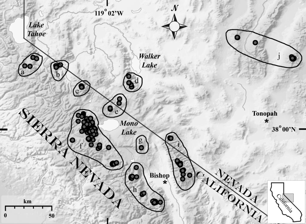
9 0 radiation, and placed either in ambient air in a rock-sheltered location at the RIF surfaces, or within RIF rock matrices ~m below the surface of the RIF. We extracted data for the warm season, defined as June September. These instruments recorded one to two seasons during the years 00 to 00, which varied by location. Results GEOGRAPHIC, ELEVATIONAL, AND GEOMORPHIC DISTRIBUTION Pika Occurrence Sites. In total, we recorded 0 pika site occurrences, distributed into demes, regions, and mountain ranges (Table ; Fig. ). These include sites in the SN ( north of Robinson Cyn, in the central SN, and south of Duck Pass); sites in the southwestern GB (including all ranges in which we searched); sites in the central GB; and sites in the Oregon Cascades. The lower numbers in the GB and Oregon relative to the SN reflect the significantly less time we spent in these areas as well as differences in non-detection. Ages of pika sites varied by region (Table ). Overall, % of the total were classed as recent, combining current (%) and modern (%), and % were old sites. The relative number of old sites increased from the SN eastward into the GB ranges: % in the SN, % in the southwestern GB ranges, and 0% in the central GB ranges. Of the sites in Oregon, all were recent. Considering the CA and NV locations, pika site elevations ranged from m to m, with an average of 0m (Table ). Oregon sites ranged from m to m. Sites averaged non-significantly higher for SN (0m) than GB (0m southwestern GB; m central GB) sites, with a narrower elevation range of the Great Basin sites. The latter may be related to the difference in our sampling and exploration efforts among the regions as well as the smaller area at high-elevation in the GB ranges compared to SN. Pika sites were distributed on all slope aspects (Fig. ), with slight preference to eastern, northeastern, and western orientations; above 00m, by contrast, pika sites were skewed to
10 0 northern and southern aspects. Of the 0 pika sites, were anthropogenic settings, including mine tailings, stone walls, rockwork dam, and historic foundations. At the remaining sites, pikas used a variety of substrates: sites were dark metamorphic, light metamorphic, granitic, dark volcanic, light volcanic, carbonate, and sedimentary in origin. Among the total, sites were in areas of at least moderate human visitation; of these were within m of heavily used recreational foot- and pack trails. Excluding the anthropogenic sites, % of the pika sites overall occurred in RIF landforms, both old and active (Table ). The most common was the boulder stream category, which accounted for % of all pika sites, with nearly equal proportions in the SN and GB. Cirque rock glaciers (RGC), old and active, were the second most common, composing % of all locations. Pika sites occurring in RGC landforms, as well as the remaining RIF category, occurred only in the SN with the exception of three sites in the Toquima Mtns. In the GB, more pika sites (0%) were in non-rif eroding bedrock slopes than in the SN (%). Unusual sites included cliff faces, Holocene lava flows, and large cave. In the Oregon Cascades, we searched only in the region of the North Sister and McKenzie Pass, both of which are areas dominated by extensive lava fields and cinder cones; all eight Oregon pika sites were in these non-rif, volcanic contexts. We recorded pika sites within the context of diverse vegetation associations, ranging from lower-elevation Artemesia and Chrysothamnus shrubland, Pinus monophylla woodland, P. jeffreyi forest, Salix riparian and wetland communities, through mid-montane forests types with P. contorta, Abies concolor, A. magnifica, or Populus tremuloides dominant, subalpine forest types including Tsuga heterophylla, Pinus contorta, P. albicaulis, P. flexilis, and P. longaeva, to many above-treeline alpine meadow, tundra, and fell-field communities. Although many sites adjoined dense grass, herb-, and forb-dominated vegetation patches, we commonly encountered sites where pika-inhabited taluses adjoined dry forest or woody shrublands with little to no plant
11 0 understory. We also commonly encountered pika sites in the midst of expansive talus environments that were distant (up to km) from obvious patches of vegetation. We encountered heavily used, active pika sites on very small tors and rocky spurs isolated from each other by km. In these situations, the intervening environments were non-rocky and supported vegetation not usually considered pika habitat, for instance, alpine meadows or sagebrush-shrub communities. We found sign of several other mammal species intermixed with pika pellets in our sites. Most common was scat of yellow-bellied marmot (Marmota flaviventris), frequent at mid- to upper elevation pika sites in all regions. Less common, and without obvious elevation association, were feces of rabbit (Lepus, Sylvilagus spp.), mule deer (Odocoileus hemionus), very small (< mm) rodent/shrew feces of diverse types and, in four instances, domestic horse (Equus caballus). Woodrat (Neotoma spp.) sign occurred in only six sites, all below 0m. Pika Non-Detection Sites. We recorded sites in otherwise optimal-appearing habitat where no pikas were detected after 0 minutes of searching (Table ). Relative to the total sites in a region (occurrence plus non-detection), these were distributed disproportionately among the regions, with % of SN sites non-detected, % of southwestern Great Basin sites non-detected, and % of central GB sites non-detected. We recorded no non-detection sites in Oregon. The average elevation of non-detection sites compared to pika occurrence sites in CA and NV was m lower, although the elevation ranges were similar between occurrence and non-detection sites (Table ). Slope aspects of non-detection sites were significantly (p < 0.0) different from those for occurrence sites, with southern aspects dominating (Fig b). Non-detection sites were far less common on RIF landforms than occurrence sites (% versus %, respectively), and far more common on rockslides, eroding bedrock, and glacial moraines (% vs %, respectively; Table ). The range of substrates on which non-detection sites occurred was similar to occurrence sites.
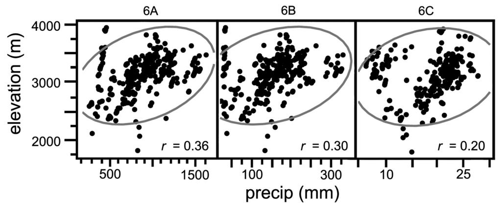
12 0 CLIMATIC RELATIONSHIPS Pika Occurrence Sites. As intersected with the PRISM climate grids, the pika sites from the SN and southwestern GB occupy a wide range of climatic conditions. Average annual precipitation for these sites ranged from to mm with an overall mean of mm (Fig. ). The sites classed as old were significantly drier than recent sites (current and modern classes combined) in annual and January precipitation (p < 0.000), but were not significantly different in July precipitation. At the latitude of our sites, most precipitation falls in winter, as evidenced by the high average precipitation in January (mm for recent sites) compared to July (mm). The distribution of precipitation values in both January and July deviated from normal by more values in the tails, with the summer distribution bimodal. Considering regional contrasts, southwestern GB pika sites were significantly drier than SN sites (Table ). In both annual and January precipitation means, southwestern GB sites averaged in the lowest % quartile for January precipitation. By contrast, GB sites averaged slightly higher July precipitation values than SN sites. Temperature values of the pika sites were also modeled with PRISM (Figs., ). Minimum temperatures for the SN and southwestern GB sites overall averaged -. C and maximum temperatures averaged. C. January minimum temperatures for all sites averaged -. C and July minimum temperatures for all sites averaged. C. January maximum temperatures averaged.0 C, and July maximum temperatures averaged.0 C. Average minimum temperatures for the old compared to recent sites were not significantly different for annual, January, or July values, although in each case the actual values of means for the old sites were lower (colder) than for the current sites. In contrast, old sites exhibited significantly higher (warmer) maximum temperatures than current sites for annual (p < 0.0), January (p < 0.0), and July (p < 0.0) means. Distributions of annual and the two monthly minimum temperatures and
13 0 also the July maximum temperature distribution were truncated or skewed, with fewer values in the warm range than in normal distribution. Comparing regions, southwestern GB sites had small but significantly lower mean minimum temperature and non-significantly higher mean maximum temperature than SN sites overall (Table ). Southwestern GB pika sites were colder than SN in minimum temperature for both January and July, whereas GB sites were warmer than SN in maximum temperature for both seasons. In general these sites reflect the more continental climate and the effect of the summer monsoon in the GB -- colder in winter, warmer in summer, overall drier but with relatively more of the annual precipitation during summer precipitation than in the SN. Correlations between elevation and climate values of pika sites (SN and southwestern GB) indicate distinct and contrasting patterns (Figs., ). Higher elevation sites had generally greater January and July precipitation, although the correlation was weak (r = 0.0 and 0.0, respectively). Minimum temperatures of pika sites had weak negative correlations with elevation (r = -0. and -0. for January and July, respectively). By contrast, maximum temperature and elevation of pika sites were strongly negatively correlated: r = -0. for average annual maximum temperature, r = -0. for January maximum temperature, and r= -0. for July maximum temperature. These contrasting trends are echoed also in low correlations of minimum and maximum temperatures: the average annual correlation (r) was 0. and the correlation of July minimum and maximum temperatures was 0. (not graphed). Warm-season air temperatures (June through September ) recorded by temperature dataloggers in till of rock glaciers and boulder streams at pika sites averaged.0 C (Table ). The mean site elevation for these instruments was m and sites ranged from m to m. Sensors placed in sheltered locations near the RIF rock surfaces were significantly warmer (p < 0.0) than those located more than m below the surface in rock matrices (means
14 0. C and. C, respectively). This difference is not readily explained by the lower elevation of locations of the surface-air versus sub-surface sensors (mean m lower), as a standard lapse rate differential (-0. /0m increase in elevation) would account for ~0. C whereas the observed difference was. C. The high extreme temperatures ranged from C to C, the latter being the upper limit of the instruments. This limit was met in three circumstances; in every case it occurred on fewer than two days. The lower range varied from C to - C, the latter being the low range limit of the units; this limit was reached on only one day for the single unit that recorded this minimum temperature. Pika Non-Detection Sites. Considering the SN and southwestern GB, climatic values estimated for the non-detection sites were significantly different (p < 0.000) from those of pika occurrence sites in discriminant analysis, and significantly different by ANOVA for all climate variables (p < 0.000) except July precipitation, where the differences were non-significant (p = 0.0). Relative to occurrence sites, non-detection sites were drier by 0mm (annual) and mm (January); warmer in minimum temperature by. C (annual),. C (January), and. C (July); and warmer in maximum temperature by.0 C (annual),. C (January), and. C (July). Discussion GEOGRAPHIC AND ELEVATIONAL DISTRIBUTION OF PIKA SITES Using a rapid-assessment method, we located and described 0 American pika site occurrences over the course of two field seasons in the Sierra Nevada (CA), southwestern Great Basin (CA and NV), and central Great Basin (NV), extending over 00m elevation, two degrees latitude ( 0. N to. N), and three degrees longitude (.0 W to. W), and in a small area in the central Oregon Cascades. While this represents only a portion of the species range, the survey greatly increases the geographic extent and number of pika sites
15 0 previously documented in CA and NV; expands information on slope aspects, substrate lithologies, and location of known sites to new mountain ranges; and refines understanding of habitat preference and climatic associations. Whereas concern exists for diminishing range of pikas relative to early surveys, the distribution and extent in our study, pertinent to four subspecies and the Pacific southwest lineage of pikas, resemble the diversity of range conditions described in early 0 th century pika records (e.g., Grinnell and Storer, ). A similar situation occurred for another lagomorph of concern, pygmy rabbit (Brachylagus idahoensis), where a rapid assessment method revealed much wider distribution than had been implied from historic population databases or resurvey efforts (Himes and Drohan, 00). Within these regions, however, and notwithstanding the relatively small number () of central Great Basin sites, the trend of increasing old sites eastward from the Sierra Nevada was strong, from only % in the SN to 0% in the central Great Basin. One interpretation of this finding is that variability in population status exists across the species range, and specifically that population viability may be lower in the central Great Basin relative to Sierra Nevada, a situation previously implicated (Beever et al., 00; Grayson, 00). Lack of association of elevation with age of sites contrasted with other studies, which have found extirpated sites to be at lowest elevations (Beever et al., 00; Beever et al., 00); our old sites occurred at low to high elevations (m-m). An alternate explanation to the increased number of old sites may be that local populations are simply be more influenced by stronger metapopulation perturbations in the isolated ranges of the central Great Basin, which doesn't automatically translate into lower viability, only to longer periods of time between extirpation and recolonization. The abundance of low elevation occupied sites in our study is noteworthy. Our lowest elevation extends the lower elevational range published for either current or historic condition. For instance, Smith (a) indicates Bodie, CA (m) locations to be at the low limit of the
16 0 species elevational range, and Smith and Weston (0) describe sites below 00m as unusual for our latitude. In our database, however, % of our sites were at or below the elevation of Bodie and % were below 00m. Hall () considers populations at 0m on Mt Rose to be marginal, and Howell () indicates the southern Sierra Nevada low-elevation range to be 0m. Our lowest site, at m, is below the historic lowest elevation of 0m recorded for the subspecies by Grinnell and Storer () in Yosemite National Park; below the low elevation range limit for the White Mountains populations given by Howell () as 0m; and below the lowest-elevation described for the southern Sierra Nevada populations of m (Sumner and Dixon, ). In resurveys of Grinnell s historic transects, Moritz et al. (00) documented an upward contraction in Yosemite Park of pikas lower elevational range by m, rendering the current lower species elevation in the Grinnell transect locations to 0m, which is 0m higher than our lowest active site. The upper elevation range of our sites (m) is higher than the historic elevation range for the SN subspecies (00m, Grinnell and Storer ), and only m below the upper range given for the southern SN and White Mountains subspecies (0m) by Howell (). Recognizing that we spent little effort searching above 00m, our survey was biased to elevations below that elevation. CLIMATIC RELATIONSHIPS Climatic dependence of pikas and vulnerability of pika habitat to global warming have been escalating concerns documented by recent research (Grayson 00; Beever et al. 00; Beever et al., 00; Moritz et al., 00) and conservation assessments (Wolf et al. 00a, b). Pikas thermal tolerance range has been considered to be quite narrow, restricting the species to cool, moist microhabitats with short summers (<0 day/yr with maximum temperatures > C), long winters (>0 days/yr with maximum temperatures <0 C), short frost-free period (<0 days/yr),
17 0 high mean annual precipitation (>00mm) (Hafner, ), and low maximum temperature extremes. Smith (a) calculated mean maximum temperature for June through September in California at a low-elevation pika population (Bodie, ~00m) as. C and at a high elevation population (near Tioga Pass, ~ 00m) as. C. At the high elevation site, no summer days exceeded C, while days exceeded this value for the warm months at the low-elevation site. Beever et al. (00) observed warm season (June to Sept ) temperatures at extant pika populations distributed through the Great Basin to average. C to. C. Vulnerability to temperature has been tested experimentally on caged pikas, which died soon after ambient (shade) temperatures reached. C. C (Smith a). These climatic values compare reasonably with our estimates from the PRISM model, although our large number of sites yielded a wider climate envelope for our region. The multiply moded distribution of precipitation values suggests pikas can tolerate a range of dry to wet conditions. Our average annual precipitation for southwestern Great Basin sites (mm) was lower than the average for extant GB sites (mm) of Beever et al. (00) and similar to the value they calculated for seven extirpated interior GB sites (mm). Our upper annual precipitation range (mm) was greater than most other estimates. The Great Basin sites in our study defined a much drier climatic envelope than our Sierran sites, the latter of which more closely resembles diversity cited for the entire species range. Temperature averages and ranges calculated from the PRISM model for our database indicated a relatively wide thermal tolerance for the species compared to published estimates. Annual (. C), January (-. C), and July (. C) average temperatures for the Sierran and southwestern Great Basin sites were much warmer and had wider ranges than those estimated previously for our region (Smith et al. a; Beever et al. 00). The truncated and skewed nature of several temperature variables suggests a recent disequilibrium in pikas range wherein
18 0 sites at warmer values have been recently abandoned and a new, normally distributed range of occupation sites has not been achieved. Whereas the pattern of these distributions aligns with other studies that indicate loss of pika sites where warm-season temperatures are high (Beever et al. 00), the similar pattern in winter minimum temperatures is less clearly interpreted. In addition to estimates of surface temperature from the PRISM model, we can compare our datalogger temperature records to Beever et al. s (00) results. At a low-elevation population slightly north of our study region in NV, Beever et al. estimated mean mid-june to late- September temperatures within rock matrices to be. C, and compared these to values ranging from. C to. C for their other Great Basin locations. Our mean mid-june to mid- September within rock-matrix temperature of. C in the Sierra Nevada was near the low range of Beever et al. s estimate, likely representing the higher elevation locations of our sensors. Our low mean within rock-matrix temperature (0. C) was colder than Beever et al. s low value, but our high mean (. C), was also colder than other estimates. We interpret these findings to suggest that pikas in our region tolerate a wider range of temperatures and precipitation than previously interpreted. GEOMORPHIC RELATIONSHIPS Pika sites occurred on a range of rocky landform classes but had clear dominance on certain categories. Whereas pika habitat is classically described as talus or rockslides (Smith and Weston, 0), the strong association in our study to RIF till, especially the boulder stream category (Millar and Westfall, 00), refines preferred pika habitat within broad hillslope categories. We found rockslides and talus cones infrequently associated with pika sites in our region, likely due to the high proportion of fine sediments, inconsistency and wide range of rock size, lack of open matrices, and frequent absence of adjacent forage opportunities. By corollary, a high proportion of non-detection sites occurred in eroded bedrock talus; these environments
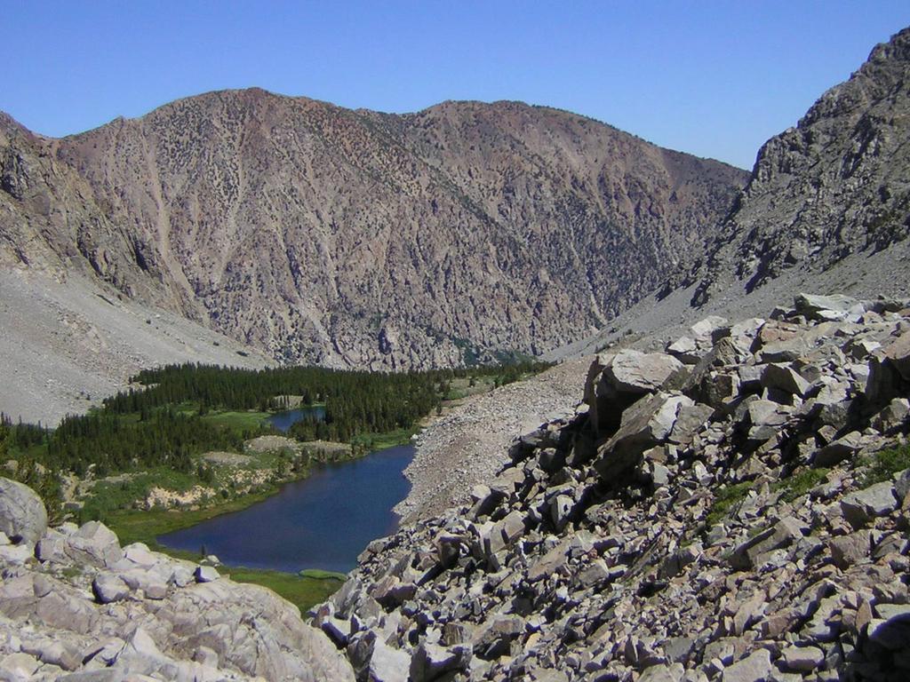
19 0 also had poorly sorted clasts with abundant fine sediments and shallow inter-rock matrices. Till of rock glacier and boulder stream landforms is generated via glacial and/or periglacial processes, characterized by repeat freeze-thaw and frozen-ground action. These autonomous processes, occurring during historic cold periods and/or persisting at present, create environments with features that appear to be highly favorable to pikas persistence, at least in the subspecies and lineages of our region. These are elaborated as follows: Rock and Rock-Matrix Conditions. The unique freeze-thaw action and clast-sorting processes of RIFs contribute to development of expansive areas of rockfields characterized by even-sized and loosely arranged rock clasts within relatively stable rock fields. Given the lithology of Sierra Nevada and Great Basin ranges (granitic, volcanic, and metamorphic, with little sedimentary), clast sizes that occur in these features are routinely in a range preferred by pikas, that is, 0..0m diameter (Tyser, 0). The sorting processes of these landforms remove soil and fine sediments, leading to deep accumulation (often many meters) of rock clasts and open matrices ideal for pikas to move, hide, eat, shelter, and den within, and from which to perch and survey. These landforms afford ample opportunity for pikas to move easily within rock openings in winter under dense snowpacks, a situation that has not been investigated. Climatic conditions of the arid Southwest (SN and GB) during historic cold periods were such as to favor extensive development of RIFs across mountain slope and even low hilly areas (Millar and Westfall, 00). The result of this is the existence, especially in the Sierra Nevada and less so in the Great Basin ranges, of abundant RIF terrain, capable of supporting one to many pika territories with relatively short distances between RIF environments. Thus, continuity for dispersal is relatively high, kin territories can be supported in single landforms, and mating potentials remain adequate within close distance. Topographic-Climatic Conditions and Intra-RIF Microclimates. The topographic contexts of rock-glacier and boulder-stream landforms are such that climatic conditions tend to
20 0 0 be cooler than means expected for their elevations (Millar and Westfall, 00). This results not only from northerly aspects of these RIFs but also from local topographic contexts that favor cold micro-sites and foster RIF development. These include steep rocky slopes; narrow and deep canyons; cirque head locations; slopes below cliffs, rock chutes, and avalanche tracks; and contexts where solar insolation is reduced and cold-air drainage, cold-air pooling, and inversions are common (Lundquist and Cayan, 00; Daly, et al., 00, 00). These conditions result in cooler summer temperatures favored by pikas, and could contribute to local depression of pikas elevation limit. Amplifying the climatic effect of cool topographic contexts are the distinctively cold microclimates created by intra-rif air circulation (Juliussen and Humlum, 00). These unique processes are of considerable interest in current periglacial research yet remain virtually unknown outside that research community. Because these are not obvious characteristics and because delineating refugial sites for pikas has high conservation priority (S. Wolf, Center for Biological Diversity, pers. comm.), we explain climatic processes here to interpret important habitat features of RIFs for pikas. RIFs generate unique microclimatic conditions within the rock landform in both summer and winter that depart from expected surface air temperatures for their elevation, topographic context, or season. During the warm season, within-rock matrix air temperatures are significantly lower than adjacent bedrock or soil, a condition known as negative thermal anomaly (Juliussen and Humlum, 00). These anomalies have been recorded as large as - C within boulder-stream talus relative to adjacent mineral soil (Harris and Pedersen, ) and up to C colder than adjacent morainal till and bedrock (Juliussen and Humlum, 00). Cold air is often felt as a persistent breeze as it circulates out the base of RIF landforms (Suwada et al., 00; Delaloye and Lambiel, 00). These unique circulation processes are known to create conditions cold and persistent enough to depress local permafrost elevations at
21 0 temperate latitudes by as much as 00m and to occur in locations where the mean annual air temperature is as high as + C (Delaloye and Lambiel, 00). Several hypotheses have been advanced to explain these intra-talus negative thermal anomalies (Ohata et al., ; von Wakonigg, ; Harris and Pedersen, ; Juliussen and Humlum, 00). Our temperature datalogger records corroborate this effect, recording warm season temperatures within rock matrices to average. C colder than sensors in rock shelters on the RIF surface. During the cold season, an opposite thermal anomaly can develop within open RIF blockfields such that within-rock matrix winter temperatures are warmer than ambient surface air (Keller and Gubler, ; Bernhard et al., ; Suwada et al., 00; Delaloye and Lambiel, 00). This occurs more commonly in the upper elevations within the rocky matrix of the landforms, in that internally heated air is ventilated upslope within the talus and exhaled through snow windows (Delaloye and Lambiel, 00) or snow funnels (Suwada et al., 00) created by the warm air. Temperatures of ventilated air have been recorded in the Japan Alps at the top of RIF blocky fields that are as much as. C warmer than air near the base of the landform over an elevational difference of only 0m (Suwada et al., 00). This pattern of RIF within-rock matrix environments being cooler than expected for elevation mean summer temperatures, and warmer than expected for winter temperatures creates highly favorable thermal conditions for pikas. This may be a primary reason explaining the importance of RIFs as important habitat. Beever found a similar functional correlation in Great Basin habitat wherein recently extirpated pika sites had both colder minimum winter temperatures and warmer maximum summer temperatures relative to actively occupied sites, implying that extant sites might be less thermally variable (Erik Beever, USGS, pers. communication, 00). The contrasting pattern of correlations between temperature and elevation in our data might also be a function of the association of pika habitat with RIFs and the unusual climatic conditions these
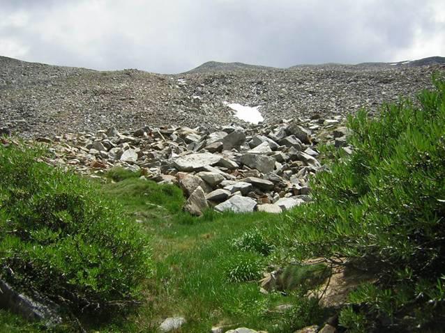
22 0 landforms have relative to elevation. Very low correlation of elevation with minimum temperatures could be a result of pika association with RIF environments, which would confound and depress temperatures relative to expected for the elevation. Hafner () found that temperature limits pika distribution more than elevation, a conclusion that also points to local environments such as RIFs creating appropriate micro-site conditions. Wetland Vegetation Communities. A final component of RIF environments conducive to pika habitat is the occurrence of dense, wetland forb, shrub, and herbaceous vegetation patches directly adjacent to RIF fronts and sides (Fig., Millar and Westfall, 00). The juxtaposition of active RIFs with wetland vegetation likely develops as a result of cool air exhalation downslope within the rock body and out the base of the RIF during the warm season, combined with persistent seepage of water out the base of the RIF. Our studies reveal that dense wetland vegetation areas occur directly below nearly all active boulder-stream and rock glacier RIFs we have surveyed (Millar and Westfall, 00), that these wetlands average more than twice the surface area of the RIFs, and that shrub and herbaceous plant species diversity is high relative to adjacent alpine and subalpine habitats in these environments (Millar and Westfall, unpublished surveys, 00-00). Such close proximity of diverse and abundant forage seems likely an important co-factor in making RIFs favored pika habitat (Huntly et al., ; Roach et al., 00). RAPID ASSESSMENT METHOD FOR SURVEYING PIKAS We developed a rapid method to assess pika presence and used this effectively in several portions of the species range (see Instructions_Form.pdf for sample survey form and instructions). We offer this as a method for opportunistic use by minimally trained observers. It can be used during any time of the day, throughout the field season as access and snowcover permit, requires little time or equipment to undertake, and applies across the geographic range of the species. This approach complements and should not replace intensive transect- and plot assessments or repeat surveys of historic
23 0 populations. The latter are essential for basic species understanding but are limited in geographic coverage due to the effort required. A potential limitation of our rapid method is that age of occupancy is only certain if pikas are actually observed or heard or if cut green vegetation is present (scored as current in our approach, and used with the same interpretation by Beever et al., 00). The other signs indicating occupancy (scored as modern ) are reliable but as they are indirect, we noted them separately. While some observers have noted that pellets remain intact for several years, our observations do not corroborate this. Even in dry and/or low-elevation environments of the western Great Basin we find that heavy rains or one winter season washes away all pellets except those concentrated in old haypile caches. Similar reliance and interpretation of pellets and other indirect signs in our method underlie the logic of the intensive pika monitoring protocol developed for British Columbia (Ministry of Environment, Lands, and Parks, ) and for a related Great Basin lagomorph, pygmy rabbit (Ulmschneider, 00). Variable decomposition time of pellets is likely in different regions of pikas range, and assigning actual age estimates to this criterion will depend on local tests for persistence of marked pellets, which we are currently undertaking. A limitation of any rapid survey is false negative results (type II error), that is, scoring a site non-detection when in fact it is occupied. In that we determined occurrence sites within - minutes with only one observer, searches at other sites beyond that time and up to one hour yielded no evidence. While these sites could well still have pika present, detection would depend on repeat visits or intensive assessments. We reconcile this problem by suggesting that in rapid surveys non-detection scores be clearly indicated as pertaining to a specified time interval, 0 minutes in our example. Such sites can thus be highlighted for re-visit with intensive survey methods. Conclusions
24 0 We developed and propose for wide use a simple and rapid survey method to assess pika presence. With it, we located and described 0 American pika site occurrences in the Sierra Nevada, Great Basin, and central Oregon. These represent mountain ranges and extend across a broad range of isolated regions, canyons within regions, and local demes. Our survey vastly increases the geographic extent and number of pika sites previously documented from our region, refines habitat preferences for pikas in the subspecies and lineages of our region, and expands knowledge of the species climatic envelope in eastern CA and western NV. The pika sites occurred on all slope aspects with minor preference for northeast and eastern orientations, and on a diverse range of representative substrate lithologies including granitic, metamorphic, and volcanic. Considering the SN and southwestern GB sites ( sites) combined, % and % of these sites respectively were evaluated as recently occupied, that is, most likely current year. The pattern of increasing old sites eastward from the Sierra Nevada was strong, from only % in the SN to 0% in the central Great Basin. This finding suggests variability across the species range even within our region, and lower viability of pikas in the GB. How such variability is influenced by differences in environment and topography, climate, and/or evolutionary relationships within the species is not clear. Excluding the eight Oregon sites, the elevational range of CA and NV sites was very broad, covering 00m elevation, and extending from a low of m to a high of m. We did not find an association of elevation with age of sites; old sites occurred at low to high elevations. This number, diversity of sites, occupancy, and elevational range suggest greater distribution in the SN and GB than has been found in other studies in our region. Our large number of sites also yielded a wider climate envelope than has been described for our region, suggesting a wide thermal tolerance for pikas there. Average minimum temperatures for the old sites were not significantly different from the recent sites, whereas average maximum temperatures were significantly higher in old relative to recent sites.
25 0 The strong association of pika sites with rock-ice feature (RIF) till, and especially the boulder stream category of RIFs (Millar and Westfall, 00), refines the preferred pika habitat within various hillslope categories that have been defined previously as pika habitat. We found rockslides and moraines little used by pikas, and ascribed the preference for RIF environments to their conditions of rock-clast and rock-matix, topographic-climatic (cold-air pooling) and intra- RIF microclimates, and associated wetlands with dense herbaceous vegetation of high pika forage value. With global warming, non-rif habitats in high likelihood will become warmer and more marginal for pikas, whereas RIF environments are highly likely to remain buffered against temperature change and lag in response to warming due to the insulation of the rocky carapace (Pelto, 00; Brenning, 00; Millar and Westfall, 00). As such, RIF environments are likely to become increasingly important refugial habitat for pikas in the future, and an effort to map and delineate such areas would be a valuable conservation exercise. In conclusion, our rapid survey results suggest that the pika populations in the Sierra Nevada and southwestern Great Basin are thriving, persist in a wide range of thermal environments, and show little evidence of extirpation or decline. Central Great Basin populations, from our relatively smaller number of sites, appear less viable, or more subject to the perturbations of metapopulation dynamics. Distribution data such as ours are important as baseline surveys that can be used in future remeasurements and further interpretation of pika ecology and population status. Conclusions from our study should be considered representative of conditions in the southwest portion of the species range only. Acknowledgements We are indebted to Erik Beever (USGS), Craig Frank (Fordham University), Don Grayson (University of Washington), Craig Moritz (University of California Berkeley), Jim Patton (University of California Berkeley), Chris Ray (University of Colorado), and David Wright (California Dept. of Fish and Game) for valuable discussions on pika distribution, behavior,
26 0 climatic relationships, and monitoring, and especially to Dan Fagre (USGS), Don Grayson, Pat Manley (USFS), Toni Lyn Morelli (USFS), and David Wright for reviews of the draft manuscript, and to two anonymous reviewers of the submitted manuscript. Special thanks to Diane Delany for rendering the figures in this manuscript. Literature Cited Beever, E.A., Brussard P.E., and Berger, J., 00: Patterns of extirpation among isolated populations of pikas (Ochotona princeps) in the Great Basin. Journal of Mammalogy, :-. Beever, E.A., Wilkening, J.L., McIvor, D.E., Weber, S.S. and Brussard, P.F., 00. American pikas (Ochotona princeps) in northwestern Nevada: A newly discovered population at a lowelevation site. Western North American Naturalist, :-. Bernhard, L., Sutter, F., Haeberli, W., and Keller, F., : Processes of snow/permafrostinteractions at a high mountain site, Murtel/Corvatsch, eastern Swiss Alps. Proceeding th International Conference on Permafrost, Yellowknife, Canada. Collection Nodicana. Centre d etudes Nordiques, Sainte-Foy, pp. -. Brenning, A., 00: Geomorphological, hydrological, and climatic significance of rock glaciers in the Andes of Central Chile. Permafrost and Periglacial Processes, :-0. Daly, C.R, Neilson, R.P., and Phillips, D.L., : A statistical-topographic model for mapping climatological precipitation over mountainous terrain. Journal of Applied Meteorology, :0-. Daly, C., Smith, J.W., Smith, J.I. and McKane, R.B., 00: High-resolution spatial modeling of daily weather elements for a catchment in the Oregon Cascade Mountains, United States. Journal of Applied Meteorology and Climatology, :-. Daly, C., Conklin, D.R., and Unsworth, M.H., 00: Local atmospheric decoupling in complex topography alters climate change impacts. International Journal of Climatology. In review.
27 0 Delaloye, R. and Lambiel, C., 00: Evidence of winter ascending air circulation throughout talus slopes and rock glaciers situation in the lower belt of alpine discontinuous permafrost (Swiss Alps). Norsk Geografisk Tidsskrift, :-0. Grayson, D.K., 00: A brief history of Great Basin pikas. Journal of Biogeography, :-. Grinnell, J., : A new cony from the vicinity of Mt. Whitney. University of California Publications in Zoology,:-. Grinnell, J., : Field tests of theories concerning distributional control. American Naturalist, :-. Grinnell, J. and Storer, T.I., : Animal life in the Yosemite. University of California Press, Berkeley, California. Hafner, D. J., : Pikas and permafrost: Post-Wisconsin historical zoogeography of Ochotona in the southern Rocky Mountains, USA. Arctic and Alpine Research, :-. Hafner, D.J. and Sullivan, R.M., : Historical and ecological biogeography of Nearctic pikas (Lagomorpha: Ochotonidae). Journal of Mammalogy, :0-. Hall, E.R., : Mammals of Nevada. University of California Press. Berkeley, California. pp. Reprinted in. Hamman, A. and Wang, T.L., 00: Models of climatic normals for genecology and climate change studies in British Columbia. Agricultural & Forest Meteorology, :-. Harris, S.A. and Pedersen, D.E., : Thermal regimes beneath coarse blocky materials. Permafrost and Periglacial Processes, :-0. Himes, J.G. and Drohan, P.J., 00: Distribution and habitat selection of the pygmy rabbit, Brachylagus idahoensis, in Nevada (USA). Journal of Arid Environments, :-. Howell, A.H., : Revision of the American pikas. North American Fauna No.. USDA Bureau of Biological Survey, Washington, D.C.
28 0 Huntly, N.J., Smith, A.T., and Ivins, B.L., : Foraging behavior of the pika (Ochotona princeps), with comparisons of grazing versus haying. Journal of Mammalogy, :-. Juliussen, H. and Humlum, O., 00: Thermal regime of openwork block fields on the mountains Elgahogna and Solen, central-eastern Norway. Permafrost and Periglacial Processes, :-. Keller, F., and Gubler, H.l., : Interaction between snow cover and high mountain permafrost. Proceedings Sixth International Conference on Permafrost, Beijing, China. South China Univ. Technology Press, Wuhan, pp. -. Lundquist, J. D., and Cayan, D.R., 00: Surface temperature patterns in complex terrain: Daily variations and long-term change in the central Sierra Nevada, California, J. Geophys. Res.,, D, doi:./00jd00. Millar, C.I. and Westfall, R.D., 00: Rock glaciers and periglacial rock-ice features in the Sierra Nevada; Classification, distribution, and climate relationships. Quaternary International, : 0-. Millar, C.I., King, J.C., Westfall, R.D., Alden, H.A., and Delany, D.L., 00: Late Holocene forest dynamics, volcanism, and climate change at Whitewing Mountain and San Joaquin Ridge, Mono County, Sierra Nevada, CA, USA. Quaternary Research :-. Ministry of Environment, Lands, and Parks, : Inventory methods for Pikas and Sciurids: Pikas, Marmots, Woodchuck, Chipmunks and Squirrels. Standards for components of British Columbia s Biodiversity No.. Resources Inventory Branch for the Terrestrial Ecosystems Task Force, Resources Inventory Committee. Vs. 0 pp. Moritz, C., Patton, J.L., Conroy, C.J., Parra, J.L., White, G.C., and Beissinger, S.R., 00: Impact of a century of climate change on small-mammal communities in Yosemite National Park, USA. Science, :-. Ohata, T., Furukawa, T., and Higuchi, K., : Glacio-climatological study of perennial ice in
29 0 the Fuji ice cave, Japan: Pt.. Seasonal variation and mechanism of maintenance. Arctic and Alpine Research, :-. Pelto, M.S., 000: Mass balance of adjacent debris-covered glaciers and clean glacier ice in the North Cascades, WA. In, Nakawo, M. (Ed.), Debris-Covered Glaciers. International Association of Hydrological Sciences Press, pp. -. Roach, W.J., Huntly, N., and Inouye, R., 00: Talus fragmentation mitigates the effects of pika, Ochotona princeps, on high alpine meadows. OIKOS, :-. SAS Institute Inc., 00: SAS Online Doc...Cary, NC: SAS Institute Inc. JMP Statistics and Graphics Guide, version. SAS Institute, Cary, NC. Smith, A. T.,a: Distribution and dispersal of pikas. Influence of behavior and climate. Ecology, :-. Smith, A. T. and Weston, M.L., 0: Mammalian species, Ochotona princeps. American Society of Mammologists, :-. Sumner, L. and Dixon, J.S., : Birds and mammals of the Sierra Nevada. University of California Press, Berkeley, California. Suwada, Y., Ishikawa, M., and Ono, Y., 00: Thermal regime of sporadic permafrost in a block slope on Mt. Nishi-Nupukaushinupuri, Hokkaido Island, Northern Japan. Geomorphology, :-0.. Tyser, R.W., 0: Use of substrate for surveillance behaviors in a community of talus slope mammals. The American Midland Naturalist, :-. Ulmschneider, H., 00: Surveying for pygmy rabbits (Brachylagus idahoensis). Fourth Draft, Idaho Bureau of Land Management Internal Document. pp. Unruh, J., Humphrey, J., and Barron, A., 00: Transtensional model for the Sierra Nevada frontal fault system, eastern California. Geology, :-0. Von Wakonigg, H., : Unterkuehlte Schutthalden. Arbt. Inst. Geographie (Graz), :0-
30 0 0. Wolf, S., Nowicki, B., and Siegel. K., 00a: Petition to list the American pika (Ochotona princeps) as threatened under the California Endangered Species Act. Center for Biological Diversity publication. San Francisco, CA. pp. Wolf, S., Nowicki, B, and Siegel. K., 00b: Petition to list the American pika (Ochotona princeps) as threatened under the United States Endangered Species Act. Center for Biological Diversity publication. San Francisco, CA. 0 pp. Figures Figure. Map of study region showing distribution of pika sites recorded in the Sierra Nevada, six southwestern Great Basin ranges, and three central Great Basin ranges, California and Nevada. Sites in Oregon are not shown. Mountain regions with pika samples include: Sierra Nevada (north, a; central, f; and southern, h); southwestern Great Basin ranges including Monitor Pass range (b), Sweetwater Mtns (c), Wassuk Range (d), Bodie Mtns (e), Glass Mtn Range (g), and White/Inyo Mtns (i); and central Great Basin ranges (j), including, from west to east, Shoshone, Toiyabe, and Toquima Ranges. Figure. Slope aspects of pika occurrence and non-detection sites in the Sierra Nevada and southwestern Great Basin ranges. Azimuths were binned into eight groups; arm lengths indicate the number of sites in that aspect group. Figures are scaled by sample size for each group, with center of diagram being zero. Figs A and Ci are scaled - to +; Figs B, Cii, and Ciii are scaled -0 to + 0. A. All pika occurrence sites (n=; longest arm, NE = ). B. Nondetection sites (n = ; longest arm, S = ). C. Sites grouped by elevation ranges, i) Pika sites >00m (n=0; longest arm NE = ). ii. Pika sites 00m (n=; longest arm N = 0). Figure. Precipitation (mm) estimated from the PRISM climate model (Daly et al. ) and adjusted for elevation, for pika sites from the Sierra Nevada and southwest Great Basin
31 0 ranges. Means are given for all sites, for recently used sites (rec; including current plus modern), and for old sites. The latter are indicated by dark shading. A. Average annual precipitation. B. Average January precipitation. C. Average July precipitation. Dark shading indicates the old sites and no shading indicates the 0 current sites. Box plots show overall mean (horizontal center of diamond), % confidence interval of the mean (upper and lower points of diamond), % and % quartiles (box boundaries), 0% density of values (bracket) and range of data (dotted line). Figure. Minimum temperatures ( C) estimated from the PRISM climate model (Daly et al. ) and adjusted for elevation, for pika sites from the Sierra Nevada and southwest Great Basin ranges. Means are given for all sites, for recently used sites (rec; including current plus modern), and for old sites. The latter are indicated by dark shading. A. Average minimum temperature. B. Average January minimum temperature. C. Average July minimum temperature. Shading for old and 0 recent sites, and box plot format as in Fig.. Figure. Maximum temperatures ( C) estimated from the PRISM climate model (Daly et al. ) and adjusted for elevation, for pika sites from the Sierra Nevada and southwest Great Basin ranges. Means are given for all sites, for recently used sites (rec; including current plus modern), and for old sites. The latter are indicated by dark shading. A. Average maximum temperature. B. Average January maximum temperature. C. Average July maximum temperature. Shading for old and 0 recent sites, and box plot format as in Fig.. Figure. Scatterplot of correlations between elevation and precipitation for pika sites from the Sierra Nevada and southwest Great Basin ranges. All pika sites combined. A. Average annual precipitation. B. Average January precipitation. C. Average July precipitation. Correlation values (r) are given for each graph. Ellipsoids indicate % concentration of values.
32 Figure. Scatterplot of correlations between elevation and temperature for pika sites from the Sierra Nevada and southwest Great Basin ranges. All pika sites combined. A. Average annual minimum temperature. B. Average January minimum temperature. C. Average July minimum temperature. D. Average annual maximum temperature. E. Average January maximum temperature. F. Average July maximum temperature. Correlation values (r) are given for each graph. Ellipsoids indicate % concentration of values. Figure. Rock glaciers and related rock-ice-features in the Sierra Nevada are typically situated in cold locations, including northward-facing cirques and valleys, and in topographic locations that favor cold-air drainage. Embedded ice and high groundwater tables provide sources for persistent water even during the dry season, which support wetlands at their bases. Together the rock features and their adjacent wetland vegetation associations create optimum pika habitat. A. Wetlands and lake at the base of rock glaciers in Oneida Canyon, Mono Basin. B. Willow-sedge association at the base of boulder streams in the upper Tuolumne River drainage, Yosemite National Park.
33
34
35
36
37
38
39
40
41
Constance I. Millar*{ and Robert D. Westfall* Abstract. Introduction 76 / ARCTIC, ANTARCTIC, AND ALPINE RESEARCH
 Arctic, Antarctic, and Alpine Research, Vol. 42, No. 1, 2010, pp. 76 88 Distribution and Climatic Relationships of the American Pika (Ochotona princeps) in the Sierra Nevada and Western Great Basin, U.S.A.;
Periglacial Geomorphology
 Periglacial Geomorphology Periglacial Geomorphology Periglacial: literally means around glacial - term introduced in 1909 to describe landforms and processes around glaciated areas. Periglacial environments:
Keys to Climate Climate Classification Low Latitude Climates Midlatitude Climates High Latitude Climates Highland Climates Our Changing Climate
 Climate Global Climates Keys to Climate Climate Classification Low Latitude Climates Midlatitude Climates High Latitude Climates Highland Climates Our Changing Climate Keys to Climate Climate the average
Tropical Moist Rainforest
 Tropical or Lowlatitude Climates: Controlled by equatorial tropical air masses Tropical Moist Rainforest Rainfall is heavy in all months - more than 250 cm. (100 in.). Common temperatures of 27 C (80 F)
The Cassiar Mountains
 The Cassiar Mountains Introduction Topography Dease Plateau Dease Lake, BC Stikine Ranges Eve Cone Mount Edziza Provincial Park Mount Ash, BC 2 125m Ketchika Ranges Muskwa- Ketchika Management Area Sifton
2. PHYSICAL SETTING FINAL GROUNDWATER MANAGEMENT PLAN. 2.1 Topography. 2.2 Climate
 FINAL GROUNDWATER MANAGEMENT PLAN 2. PHYSICAL SETTING Lassen County is a topographically diverse area at the confluence of the Cascade Range, Modoc Plateau, Sierra Nevada and Basin and Range geologic provinces.
Chapter 6, Part Colonizers arriving in North America found extremely landscapes. It looked different to region showing great.
 Social Studies 9 Unit 1 Worksheet Chapter 6, Part 1. 1. Colonizers arriving in North America found extremely landscapes. It looked different to region showing great. 2. The Earth is years old and is composed
Mass Wasting: The Work of Gravity
 Chapter 15 Lecture Earth: An Introduction to Physical Geology Twelfth Edition Mass Wasting: The Work of Gravity Tarbuck and Lutgens Chapter 15 Mass Wasting The Importance of Mass Wasting Slopes are the
National Wildland Significant Fire Potential Outlook
 National Wildland Significant Fire Potential Outlook National Interagency Fire Center Predictive Services Issued: September, 2007 Wildland Fire Outlook September through December 2007 Significant fire
Thermal Components of American Pika Habitat How does a Small Lagomorph Encounter Climate?
 Thermal Components of American Pika Habitat How does a Small Lagomorph Encounter Climate? Author(s): Constance I. Millar, Robert D. Westfall and Diane L. Delany Source: Arctic, Antarctic, and Alpine Research,
2011 National Seasonal Assessment Workshop for the Eastern, Southern, & Southwest Geographic Areas
 2011 National Seasonal Assessment Workshop for the Eastern, Southern, & Southwest Geographic Areas On January 11-13, 2011, wildland fire, weather, and climate met virtually for the ninth annual National
Preliminaries to Erosion: Weathering and Mass Wasting
 Preliminaries to Erosion: Weathering & Mass Wasting All things deteriorate in time. Virgil 1 Preliminaries to Erosion: Weathering and Mass Wasting Denudation The Impact of Weathering and Mass Wasting on
Match up the pictures and key terms
 Match up the pictures and key terms 1 Plucking Striations 3 Roche Mountonnees 2 Chatter Marks 4 What is the difference between plucking and abrasion? Glacial Processes Erosion, Weathering and Deposition
National Wildland Significant Fire Potential Outlook
 National Wildland Significant Fire Potential Outlook National Interagency Fire Center Predictive Services Issued: April 1, 2008 Next Issue: May 1, 2008 Wildland Fire Outlook April 2008 through July 2008
Page 1. Name:
 Name: 1) Which property would best distinguish sediment deposited by a river from sediment deposited by a glacier? thickness of sediment layers age of fossils found in the sediment mineral composition
The elevations on the interior plateau generally vary between 300 and 650 meters with
 11 2. HYDROLOGICAL SETTING 2.1 Physical Features and Relief Labrador is bounded in the east by the Labrador Sea (Atlantic Ocean), in the west by the watershed divide, and in the south, for the most part,
World Geography Chapter 3
 World Geography Chapter 3 Section 1 A. Introduction a. Weather b. Climate c. Both weather and climate are influenced by i. direct sunlight. ii. iii. iv. the features of the earth s surface. B. The Greenhouse
Gateway Trail Project
 Gateway Trail Project Debris Flow Hazard Assessment By: Juan de la Fuente April 30, 2010 Background- On April 22, 2010, the Shasta-Trinity National Forest (Mt. Shasta-McCloud Unit) requested a geologic
Foundations of Earth Science, 6e Lutgens, Tarbuck, & Tasa
 Foundations of Earth Science, 6e Lutgens, Tarbuck, & Tasa Weather Patterns and Severe Weather Foundations, 6e - Chapter 14 Stan Hatfield Southwestern Illinois College Air masses Characteristics Large body
Social Studies. Chapter 2 Canada s Physical Landscape
 Social Studies Chapter 2 Canada s Physical Landscape Introduction Canada s geography its landforms and climate - has a great impact on Canadians sense of identity. Planet Earth The earth is divided into
A SURVEY OF HYDROCLIMATE, FLOODING, AND RUNOFF IN THE RED RIVER BASIN PRIOR TO 1870
 A SURVEY OF HYDROCLIMATE, FLOODING, AND RUNOFF IN THE RED RIVER BASIN PRIOR TO 1870 W. F. RANNIE (UNIVERSITY OF WINNIPEG) Prepared for the Geological Survey of Canada September, 1998 TABLE OF CONTENTS
Lecture 10 Glaciers and glaciation
 Lecture 10 Glaciers and glaciation Outline Importance of ice to people! Basics of glaciers formation, classification, mechanisms of movement Glacial landscapes erosion and deposition by glaciers and the
Weather and Climate Summary and Forecast Winter
 Weather and Climate Summary and Forecast Winter 2016-17 Gregory V. Jones Southern Oregon University February 7, 2017 What a difference from last year at this time. Temperatures in January and February
An ENSO-Neutral Winter
 An ENSO-Neutral Winter This issue of the Blue Water Outlook newsletter is devoted towards my thoughts on the long range outlook for winter. You will see that I take a comprehensive approach to this outlook
Use of benthic invertebrate biological indicators in evaluating sediment deposition impairment on the Middle Truckee River, California
 Use of benthic invertebrate biological indicators in evaluating sediment deposition impairment on the Middle Truckee River, California David B. Herbst Sierra Nevada Aquatic Research Laboratory University
The subject paper is being submitted for approval for publication in the annual volume entitled Geological Survey Research.
 Water Resources Division 345 Middlefield Road Menlo Park, California January 12, 1965 Memorandum To: Mr. Frank E. Clark, Chief, General Hydrology Branch Thru: Area Hydrologist PCA From: Valmore C. LaMarche
GLOBAL CLIMATES FOCUS
 which you will learn more about in Chapter 6. Refer to the climate map and chart on pages 28-29 as you read the rest of this chapter. FOCUS GLOBAL CLIMATES What are the major influences on climate? Where
Glaciers form wherever snow and ice can accumulate High latitudes High mountains at low latitudes Ice temperatures vary among glaciers Warm
 The Cryosphere Glaciers form wherever snow and ice can accumulate High latitudes High mountains at low latitudes Ice temperatures vary among glaciers Warm (temperate) glaciers: at pressure melting point,
CORRELATION OF CLIMATIC AND SOLAR VARIATIONS OVER THE PAST 500 YEARS AND PREDICTING GLOBAL CLIMATE CHANGES FROM RECURRING CLIMATE CYCLES
 Easterbrook, D.J., 2008, Correlation of climatic and solar variations over the past 500 years and predicting global climate changes from recurring climate cycles: International Geological Congress, Oslo,
The Global Scope of Climate. The Global Scope of Climate. Keys to Climate. Chapter 8
 The Global Scope of Climate Chapter 8 The Global Scope of Climate In its most general sense, climate is the average weather of a region, but except where conditions change very little during the course
Weather and Climate of the Rogue Valley By Gregory V. Jones, Ph.D., Southern Oregon University
 Weather and Climate of the Rogue Valley By Gregory V. Jones, Ph.D., Southern Oregon University The Rogue Valley region is one of many intermountain valley areas along the west coast of the United States.
2015: A YEAR IN REVIEW F.S. ANSLOW
 2015: A YEAR IN REVIEW F.S. ANSLOW 1 INTRODUCTION Recently, three of the major centres for global climate monitoring determined with high confidence that 2015 was the warmest year on record, globally.
Ecoregions Glossary. 7.8B: Changes To Texas Land Earth and Space
 Ecoregions Glossary Ecoregions The term ecoregions was developed by combining the terms ecology and region. Ecology is the study of the interrelationship of organisms and their environments. The term,
Some Periglacial Morphology in the Sagarmatha. (Everest) Region, Khumbu Himal*
 Region, Khumbu Himal*") Seppyo, 1976 S. Iwata 115 Some Periglacial Morphology in the Sagarmatha (Everest) Region, Khumbu Himal* Shuji Iwata** Abstract The periglacial morphology in the Sagarmatha region, Khumbu Himal, was surveyed
Seppyo, 1976 S. Iwata 115 Some Periglacial Morphology in the Sagarmatha (Everest) Region, Khumbu Himal* Shuji Iwata** Abstract The periglacial morphology in the Sagarmatha region, Khumbu Himal, was surveyed
Northwest Outlook October 2016
 Northwest Outlook October 2016 Rainfall Opportunities and Challenges Rainfall over the month of September presented some challenges for the fall harvest while other producers benefitted. Figure 1a shows
DEPARTMENT OF EARTH & CLIMATE SCIENCES Name SAN FRANCISCO STATE UNIVERSITY Nov 29, ERTH 360 Test #2 200 pts
 DEPARTMENT OF EARTH & CLIMATE SCIENCES Name SAN FRANCISCO STATE UNIVERSITY Nov 29, 2018 ERTH 360 Test #2 200 pts Each question is worth 4 points. Indicate your BEST CHOICE for each question on the Scantron
PHYSICAL GEOGRAPHY. By Brett Lucas
 PHYSICAL GEOGRAPHY By Brett Lucas WEATHERING & MASS WASTING Denudation Disintegration, wearing away, and removal of rock material Involves three activities: Weathering is the break down of rocks into smaller
1. Which type of climate has the greatest amount of rock weathering caused by frost action? A) a wet climate in which temperatures remain below
 a wet climate in which temperatures remain below") 1. Which type of climate has the greatest amount of rock weathering caused by frost action? A) a wet climate in which temperatures remain below freezing B) a wet climate in which temperatures alternate
1. Which type of climate has the greatest amount of rock weathering caused by frost action? A) a wet climate in which temperatures remain below freezing B) a wet climate in which temperatures alternate
Which map shows the stream drainage pattern that most likely formed on the surface of this volcano? A) B)
 B)") 1. When snow cover on the land melts, the water will most likely become surface runoff if the land surface is A) frozen B) porous C) grass covered D) unconsolidated gravel Base your answers to questions
1. When snow cover on the land melts, the water will most likely become surface runoff if the land surface is A) frozen B) porous C) grass covered D) unconsolidated gravel Base your answers to questions
Weather History on the Bishop Paiute Reservation
 Weather History on the Bishop Paiute Reservation -211 For additional information contact Toni Richards, Air Quality Specialist 76 873 784 toni.richards@bishoppaiute.org Updated 2//214 3:14 PM Weather History
How do glaciers form?
 Glaciers What is a Glacier? A large mass of moving ice that exists year round is called a glacier. Glaciers are formed when snowfall exceeds snow melt year after year Snow and ice remain on the ground
L.O Students will learn about factors that influences the environment
 Name L.O Students will learn about factors that influences the environment Date 1. At the present time, glaciers occur mostly in areas of A) high latitude or high altitude B) low latitude or low altitude
Weathering, Erosion, Deposition, and Landscape Development
 Weathering, Erosion, Deposition, and Landscape Development I. Weathering - the breakdown of rocks into smaller particles, also called sediments, by natural processes. Weathering is further divided into
Our climate system is based on the location of hot and cold air mass regions and the atmospheric circulation created by trade winds and westerlies.
 CLIMATE REGIONS Have you ever wondered why one area of the world is a desert, another a grassland, and another a rainforest? Or have you wondered why are there different types of forests and deserts with
Chapter 1 Section 2. Land, Water, and Climate
 Chapter 1 Section 2 Land, Water, and Climate Vocabulary 1. Landforms- natural features of the Earth s land surface 2. Elevation- height above sea level 3. Relief- changes in height 4. Core- most inner
Unit 7.2 W.E.D. & Topography Test
 Name: Score: Unit 7.2 W.E.D. & Topography Test 1. 2. 3. 4. 5. 6. 7. 8. 9. 10. 11. 12. 13. 14. 15. 16. 17. 18. 19. 20. 21. 22. 23. 24. 25. 1. The formation of mountains is due mainly to while the destruction
NRC Workshop - Probabilistic Flood Hazard Assessment Jan 2013
 Regional Precipitation-Frequency Analysis And Extreme Storms Including PMP Current State of Understanding/Practice Mel Schaefer Ph.D. P.E. MGS Engineering Consultants, Inc. Olympia, WA NRC Workshop - Probabilistic
Unit 2. United States Physical Geography
 Unit 2 United States Physical Geography Physical Geography U.S. extends from the Atlantic to Pacific U.S. is the 3rd largest country U.S. has fertile soils, vast forests, and variety of minerals All major
Chapter 6. Field Trip to Sandia Mountains.
 University of New Mexico Biology 310L Principles of Ecology Lab Manual Page -40 Chapter 6. Field Trip to Sandia Mountains. Outline of activities: 1. Travel to Sandia Mountains 2. Collect forest community
Winter. Here s what a weak La Nina usually brings to the nation with tempseraures:
 2017-2018 Winter Time again for my annual Winter Weather Outlook. Here's just a small part of the items I considered this year and how I think they will play out with our winter of 2017-2018. El Nino /
Earth s Major Terrerstrial Biomes. *Wetlands (found all over Earth)
") Biomes Biome: the major types of terrestrial ecosystems determined primarily by climate 2 main factors: Depends on ; proximity to ocean; and air and ocean circulation patterns Similar traits of plants
Biomes Biome: the major types of terrestrial ecosystems determined primarily by climate 2 main factors: Depends on ; proximity to ocean; and air and ocean circulation patterns Similar traits of plants
Extent of Periglacial = Global Permafrost Permafrost: Soil and/or rock where temperatures remain below 0 degrees C for 2 or more years.
 Geog 1000 - Lecture 34 Periglacial Environments and Paleoclimatology http://scholar.ulethbridge.ca/chasmer/classes/ Today s Lecture (Pgs 422-434) 1. Exam questions from last week, and today 2. Extent of
Variability Across Space
 Variability and Vulnerability of Western US Snowpack Potential impacts of Climactic Change Mark Losleben, Kurt Chowanski Mountain Research Station, University of Colorado Introduction The Western United
Energy Systems, Structures and Processes Essential Standard: Analyze patterns of global climate change over time Learning Objective: Differentiate
 Energy Systems, Structures and Processes Essential Standard: Analyze patterns of global climate change over time Learning Objective: Differentiate between weather and climate Global Climate Focus Question
Weather and Climate Summary and Forecast March 2018 Report
 Weather and Climate Summary and Forecast March 2018 Report Gregory V. Jones Linfield College March 7, 2018 Summary: The ridge pattern that brought drier and warmer conditions from December through most
The Climate of Oregon Climate Zone 4 Northern Cascades
 /05 E55 Unbound issue No. 9/ is Does not circulate Special Report 916 May 1993 The Climate of Oregon Climate Zone 4 Property of OREGON STATE UNIVERSITY Library Serials Corvallis, OR 97331-4503 Agricultural
Mapping the extent of temperature-sensitive snowcover and the relative frequency of warm winters in the western US
 Mapping the extent of temperature-sensitive snowcover and the relative frequency of warm winters in the western US Anne Nolin Department of Geosciences Oregon State University Acknowledgements Chris Daly,
Geomorphology Of The Chilliwack River Watershed Landform Mapping At North Cascades National Park Service Complex, Washington By National Park Service
 Geomorphology Of The Chilliwack River Watershed Landform Mapping At North Cascades National Park Service Complex, Washington By National Park Service READ ONLINE Snowshed contributions to the Nooksack
Sierra Nevada Hydroclimatology: An Experimental Prediction of Maximum Daily Snowmelt Discharge in 2005
 Sierra Nevada Hydroclimatology: An Experimental Prediction of Maximum Daily Snowmelt Discharge in 2005 David Peterson, Jessica Lundquist, Iris Stewart, Noah Knowles, Madeline Solomon and Stephen Hager
3. The map below shows an eastern portion of North America. Points A and B represent locations on the eastern shoreline.
 1. Most tornadoes in the Northern Hemisphere are best described as violently rotating columns of air surrounded by A) clockwise surface winds moving toward the columns B) clockwise surface winds moving
Prentice Hall EARTH SCIENCE
 Prentice Hall EARTH SCIENCE Tarbuck Lutgens Chapter 21 Climate 21.1 Factors That Affect Climate Factors That Affect Climate Latitude As latitude increases, the intensity of solar energy decreases. The
Chapter 52 An Introduction to Ecology and the Biosphere
 Chapter 52 An Introduction to Ecology and the Biosphere Ecology The study of the interactions between organisms and their environment. Ecology Integrates all areas of biological research and informs environmental
Eagle Creek Post Fire Erosion Hazard Analysis Using the WEPP Model. John Rogers & Lauren McKinney
 Eagle Creek Post Fire Erosion Hazard Analysis Using the WEPP Model John Rogers & Lauren McKinney Columbia River Gorge at Risk: Using LiDAR and GIS-based predictive modeling for regional-scale erosion susceptibility
Chemistry 8 Chapter 7 Review Kinetic Molecular Theory 1. Define Mass The amount of matter in a substance or object.
 Chemistry 8 Chapter 7 Review Kinetic Molecular Theory 1. Define Mass The amount of matter in a substance or object. 2. Define Volume The amount of space taken up by a substance or object. 3. What are the
Development of statewide 30 meter winter sage grouse habitat models for Utah
 Development of statewide 30 meter winter sage grouse habitat models for Utah Ben Crabb, Remote Sensing and Geographic Information System Laboratory, Department of Wildland Resources, Utah State University
 Page 1 of 9 Name: Base your answer to the question on the diagram below. The arrows show the direction in which sediment is being transported along the shoreline. A barrier beach has formed, creating a
Fig Major air masses of the world
 Fig. 9.3 Major air masses of the world CLASSIFICATION FOUR BASIC CATEGORIES OF AIR MASSES: POLAR - P ARCTIC - A TROPICAL - T EQUATORIAL - E TWO DESIGNATIONS OF SURFACE IN SOURCE REGION MARITIME - m. CONTINENTAL
Midterm Review. Nata/Lee
 Name: 1. Which statement best supports the theory that all the continents were once a single landmass? (1) Rocks of the ocean ridges are older than those of the adjacent sea floor. (2) Rock and fossil
mountain rivers fixed channel boundaries (bedrock banks and bed) high transport capacity low storage input output
 high transport capacity low storage input output") mountain rivers fixed channel boundaries (bedrock banks and bed) high transport capacity low storage input output strong interaction between streams & hillslopes Sediment Budgets for Mountain Rivers Little
mountain rivers fixed channel boundaries (bedrock banks and bed) high transport capacity low storage input output strong interaction between streams & hillslopes Sediment Budgets for Mountain Rivers Little
Timing and magnitude of late Pleistocene and Holocene glaciations in Yosemite National Park
 National Park Service U.S. Department of the Interior Yosemite National Park Timing and magnitude of late Pleistocene and Holocene glaciations in Yosemite National Park Greg Stock Yosemite National Park
PERIGLACIAL PROCESSES & LANDFORMS
 PERIGLACIAL PROCESSES & LANDFORMS Periglacial processes all non-glacial processes in cold climates average annual temperature between -15 C and 2 C fundamental controlling factors are intense frost action
MET Lecture 20 Mountain Snowstorms (CH16)
") MET 4300 Lecture 20 Mountain Snowstorms (CH16) Learning Objectives Provide an overview of the importance and impacts of mountain snowstorms in the western US Describe how topography influence precipitation
MET 4300 Lecture 20 Mountain Snowstorms (CH16) Learning Objectives Provide an overview of the importance and impacts of mountain snowstorms in the western US Describe how topography influence precipitation
Chapter 1: America s Land Lesson 1: Land and Climate
 Chapter 1: America s Land Lesson 1: Land and Climate Geography: Describe landforms and other physical features of the United States. Geography: Explain how and why climate varies throughout the United
Spatial Survey of Surface Soil Moisture in a Sub-alpine Watershed Colloquium Presentation, University of Denver, Department of Geography
 Thank you all for coming today. I will be talking about my thesis work concerning the spatial distribution of soil moisture in an alpine catchment. But first we need some background in soil moisture. Why
Museum of Vertebrate Zoology, UC Berkeley
 Museum of Vertebrate Zoology, UC Berkeley Non-specimen archival record (fieldnotes and photographs)... our efforts are not... to accumulate as great a mass of animal remains as possible [rather]... our
How does the physical environment influence communities and ecosystems? Hoodoos in Cappadocia, Turkey
 Biomes of the World How does the physical environment influence communities and ecosystems? Hoodoos in Cappadocia, Turkey ecosystems are shaped by: abiotic factors climate/weather space Rainfall Soil air
COOLING DRYING 19 4 CT WT CT AR. mean global temperature levels of aridity latitudinal stratification have all changed appreciably
 as we have seen. BIOMES are the biota's adaptive response to earth's climate zones but climate too has a history - - it has evolved through time mean global temperature levels of aridity latitudinal stratification
Bell Ringer. Are soil and dirt the same material? In your explanation be sure to talk about plants.
 Bell Ringer Are soil and dirt the same material? In your explanation be sure to talk about plants. 5.3 Mass Movements Triggers of Mass Movements The transfer of rock and soil downslope due to gravity is
THE MAMMOTH "EARTHQUAKE FAULT" AND RELATED FEATURES IN MON0 COUNTY, CALIFORNIA* By H. BENIOFF and B. GUTENBERG
 THE MAMMOTH "EARTHQUAKE FAULT" AND RELATED FEATURES IN MON0 COUNTY, CALIFORNIA* By H. BENIOFF and B. GUTENBERG IN UNDERTAKING this work it was our intention to investigate the well-known "Earthquake Fault"
UNIT 5: ECOLOGY Chapter 15: The Biosphere
 CORNELL NOTES Directions: You must create a minimum of 5 questions in this column per page (average). Use these to study your notes and prepare for tests and quizzes. Notes will be stamped after each assigned
School Name Team # International Academy East Meteorology Test Graphs, Pictures, and Diagrams Diagram #1
 School Name Team # International Academy East Meteorology Test Graphs, Pictures, and Diagrams Diagram #1 Use the map above, and the locations marked A-F, to answer the following questions. 1. The center
The United States & Canada. A Regional Study of Anglo America
 A Regional Study of Anglo America Landform Regions of the United States & Canada world leaders in agricultural and industrial production because of... VAST LANDS stretch from the Atlantic Ocean on the
OBSERVING AND MAPPING THE ROCK STREAMS AND QUARRIES IN SOME MASSIFS FROM THE ROMANIAN CARPATHIANS BY MEANS OF SATELLITE IMAGES
 VASILE LOGHIN 371 OBSERVING AND MAPPING THE ROCK STREAMS AND QUARRIES IN SOME MASSIFS FROM THE ROMANIAN CARPATHIANS BY MEANS OF SATELLITE IMAGES Key words: rock streams, quarries, satellite images, Carpathians
Weather and Climate Change
 Weather and Climate Change What if the environmental lapse rate falls between the moist and dry adiabatic lapse rates? The atmosphere is unstable for saturated air parcels but stable for unsaturated air
Glaciers Earth 9th Edition Chapter 18 Glaciers: summary in haiku form Key Concepts Glaciers Glaciers Glaciers Glaciers
 1 2 3 4 5 6 7 8 9 10 11 12 13 14 Earth 9 th Edition Chapter 18 : summary in haiku form Ten thousand years thence big glaciers began to melt - called "global warming." Key Concepts and types of glaciers.
3.3 CLIMATE, GEOLOGY, TOPOGRAPHY, AND SOILS CLIMATE GEOLOGY TOPOGRAPHY
 3.3 CLIMATE, GEOLOGY, TOPOGRAPHY, AND SOILS This section describes the climate, geology, topography, and soil resource characteristics of the Yolo Bypass Wildlife Area (Wildlife Area). Agricultural soil
Chapter outline. Reference 12/13/2016
 Chapter 2. observation CC EST 5103 Climate Change Science Rezaul Karim Environmental Science & Technology Jessore University of science & Technology Chapter outline Temperature in the instrumental record
RaysWeather.Com Winter Fearless Forecast
 Author: Dr. Ray Russell Founder and President of RaysWeather.Com Date: October 19, 2017 RaysWeather.Com 2018-2019 Winter Fearless Forecast Background Unseasonably warm weather continues this fall no frost
Weather and Climate Summary and Forecast February 2018 Report
 Weather and Climate Summary and Forecast February 2018 Report Gregory V. Jones Linfield College February 5, 2018 Summary: For the majority of the month of January the persistent ridge of high pressure
Spheres of Life. Ecology. Chapter 52. Impact of Ecology as a Science. Ecology. Biotic Factors Competitors Predators / Parasites Food sources
 "Look again at that dot... That's here. That's home. That's us. On it everyone you love, everyone you know, everyone you ever heard of, every human being who ever was, lived out their lives. Ecology Chapter
The Documentation of Extreme Hydrometeorlogical Events: Two Case Studies in Utah, Water Year 2005
 The Documentation of Extreme Hydrometeorlogical Events: Two Case Studies in Utah, Water Year 2005 Tim Bardsley1*, Mark Losleben2, Randy Julander1 1. USDA, NRCS, Snow Survey Program, Salt Lake City, Utah.
Laboratory Exercise #4 Geologic Surface Processes in Dry Lands
 Page - 1 Laboratory Exercise #4 Geologic Surface Processes in Dry Lands Section A Overview of Lands with Dry Climates The definition of a dry climate is tied to an understanding of the hydrologic cycle
Lecture Outlines PowerPoint. Chapter 6 Earth Science 11e Tarbuck/Lutgens
 Lecture Outlines PowerPoint Chapter 6 Earth Science 11e Tarbuck/Lutgens 2006 Pearson Prentice Hall This work is protected by United States copyright laws and is provided solely for the use of instructors
How does the greenhouse effect maintain the biosphere s temperature range? What are Earth s three main climate zones?
 Section 4 1 The Role of Climate (pages 87 89) Key Concepts How does the greenhouse effect maintain the biosphere s temperature range? What are Earth s three main climate zones? What Is Climate? (page 87)
Climate Change 2007: The Physical Science Basis
 Climate Change 2007: The Physical Science Basis Working Group I Contribution to the IPCC Fourth Assessment Report Presented by R.K. Pachauri, IPCC Chair and Bubu Jallow, WG 1 Vice Chair Nairobi, 6 February
Weather and Climate Summary and Forecast March 2019 Report
 Weather and Climate Summary and Forecast March 2019 Report Gregory V. Jones Linfield College March 2, 2019 Summary: Dramatic flip from a mild winter to a top five coldest February on record in many locations
 12 10 8 6 4 2 0 40-50 50-60 60-70 70-80 80-90 90-100 Fresh Water What we will cover The Hydrologic Cycle River systems Floods Groundwater Caves and Karst Topography Hot springs Distribution of water in
Seasonal associations between mid-tropospheric height patterns and precipitation in the western Great Basin, USA
 Seasonal associations between mid-tropospheric height patterns and precipitation in the western Great Basin, USA By: Paul A. Knapp Knapp, P.A. (1994) Seasonal associations between mid-tropospheric pressure
A Geological Tour of Tumbledown Mountain, Maine
 Maine Geologic Facts and Localities April, 1998 A Geological Tour of Tumbledown Mountain, Maine 44 45 3.21 N, 70 32 50.24 W Text by Robert G. Marvinney, Department of Agriculture, Conservation & Forestry
Weather and Climate Summary and Forecast January 2018 Report
 Weather and Climate Summary and Forecast January 2018 Report Gregory V. Jones Linfield College January 5, 2018 Summary: A persistent ridge of high pressure over the west in December produced strong inversions