Variations of b-values at the western edge of the Ryukyu Subduction Zone, north-east Taiwan
|
|
|
- Lesley Armstrong
- 6 years ago
- Views:
Transcription
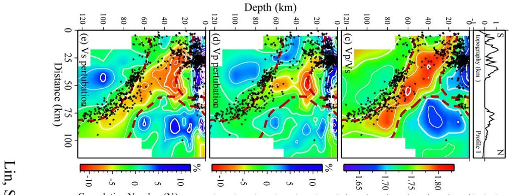
1 Please note that this is an author-produced PDF of an article accepted for publication following peer review. The definitive publisher-authenticated version is available on the publisher Web site Terra Nova April 2008, Volume 20 Issue 2 : Pages Blackwell Publishing, Inc. The definitive version is available at Archimer, archive institutionnelle de l Ifremer Variations of b-values at the western edge of the Ryukyu Subduction Zone, north-east Taiwan Jing-Yi Lin 1, 2, *, Jean-Claude Sibuet 2, Shu-Kun Hsu 3 1 Collège de France, Chaire de Géodynamique, Europôle de l'arbois, Bat. Le Trocadéro - Aile Sud, BP 80, Aix en Provence cedex 4, France 2 Ifremer, Centre de Brest, DRO/GM, B.P. 70, Plouzané, France 3 Institute of Geophysics, National Central University, Chung-Li 32001, Taiwan *: Corresponding author : Jing-Yi Lin, Tel: (33) Fax: (33) , address : lin@cdf.u-3mrs.fr Abstract: Using earthquakes relocated in north-east Taiwan, we estimated b-value distribution along a crosssection located near the Ryukyu slab edge, and four b-value anomalous areas are evidenced: (1) a high b-value body lying on top of a low Vp, low Vs and high Vp/Vs sausage-like body was considered as a region of enhanced partial melt or water supply above which seismicity occurs; (2) beneath the Ilan Plain, an anomalous area characterized by b-values slightly higher than 1.1 might give evidence to the magma conduits to the Kueishantao Island; (3) above the Ryukyu Wadati-Benioff zone, at depths ranging from 90 to 110 km, a high b-value anomaly might correspond to the depth where dehydration occurs in the subducting oceanic plate; and (4) a low b-value area located within the Ryukyu slab, at depths ranging from 70 to 90 km, might be linked to the compressive mechanisms shown by focal mechanisms and the bending of the subducting plate. Introduction 1. In the westernmost part of the Ryukyu subduction zone where the Philippine Sea (PH) plate converges with the Eurasia (EU) plate at about 8 cm/yr along the N306 direction (Yu et al., 1997) (Figure 1), horizontal compression prevails in the upper plate as suggested by earthquake focal mechanisms (Kao et al., 1998). By using the earthquake distribution, the geometry of the western extremity of the Ryukyu slab was roughly defined (Figures 2a and 2b) (Kao et al., 1998; Font et al., 1999; Chou et al., 2006). More recently, the plate border was imaged by tomographic results. A low Vp, low Vs and high Vp/Vs sausage-like body, about 30 km in diameter was located at depths ranging between 20 and 100 km on top of the western Ryukyu slab extremity 1
2 (Lin et al., 2004) (north-dipping dashed contour in Figures 2c to 2g). This body might be the result of asthenospheric rising flow around the slab edge and might be associated with partial melting and/or an increase in H 2 O content. The existence of a magmatic pathway rising from the sausage-like body in direction of the andesitic Kueishantao Island (north-rising dashed contour in Figures 2c to 2g) explains why a slab component was found in the geochemical analyses of the andesites (Lin et al., 2004; Shinjo, 1999). In this study, b-value distributions will be calculated near the Ryukyu slab border where complex tectonic mechanisms are involved and compared with tomographic results. 2. The Gutenberg-Richter frequency-magnitude relationship logn=a-bm (Ishimoto and Iida, 1939; Gutenberg and Richter, 1944) gives the number N of events, with a magnitude equal or larger than M (cumulative distribution), a and b being positive, real constants. The parameter b is the slope of the best fitting line of the observed number N in function of the magnitude M (Figure 2h). 3. The decrease of b is interpreted in terms of stress variations depending on either material heterogeneity (Mogi, 1962), stress increase before a main seismic event (Scholz, 1968; Wyss, 1973) or stress decrease with high thermal gradients (Warren and Latham, 1970). For laboratory experiments (Scholz, 1968) and mine excavation measurements (Urbancic et al., 1992), b-values display an inverse relationship with stress: low b-values are linked to higher stress, and high b- values are linked to lower stress. High b-values have been reported in volcanic areas surrounding magma chambers (Warren and Latham, 1970) and in the area of geothermal systems (Wiemer and Wyss, 1997; Wiemer et al., 1998; Murru et al., 1999). High b-value anomalies have been also reported at depths of km in the Alaskan and New-Zealand subduction zones (Wiemer and Benoit, 1996) and within the subducted slab beneath northeastern Japan (Wyss et al., 2001), 3
3 reflecting slab dehydration and a subsequent increase in pore pressure and a decrease of the effective stress. Data and Method 4. Relocation of the earthquakes recorded by the Central Weather Bureau (CWB) from December 1990 to May 1999 in northern Taiwan has been performed by Lin et al. (2004) earthquakes located north of 23.5 N latitude were relocated with the SIMUL2000 program (Thurber and Eberhart-Phillips, 1999) (Figure 1). 5. The distribution of earthquakes is not homogeneous in northern Taiwan. Most of the earthquakes are associated with the Ryukyu slab while the shallow seismicity around the Ilan Plain is linked to the backarc opening and the left-lateral motion along the Lishan Fault (Figure 1). We thus decided to apply the b-value calculation along a cross-section located near the Ryukyu slab edge (Figures 1 and 2a). Along this cross-section, the earthquake distribution is dense enough to get a reliable b-value estimation (Figures 1, 2c to 2e). The Zmap software (Wiemer, 2001; Wiemer and Wyss, 1994 and 1997) was used to determine the spatial distribution of b. In total, 884 earthquakes located within 15 km on each side of the cross-section have been selected and projected perpendicularly to the cross-section. Sampling volumes are cylinders around a horizontal axis. A sliding spatial window was used to analyze the b-values in function of depth with a 5 x 5 km grid. b-values were calculated in cylinder-shaped volumes with varying radii in order to sample a constant number of events. A constant number of events in each sample is preferred rather than windows with constant width spacing to ensure that a change in sample size does not affect the results. The final number of events in each cylinder was a compromise 4
4 between the spatial resolution and the smoothing effect of large windows and we used 100 events as in similar studies (Wiemer and Benoit, 1996; Power et al., 1998). The resolution is thus a function of cylinder radii (Figure 2g). 6. The completeness of the earthquake catalogue, i.e. the estimation of the so-called threshold magnitude Mc is critical. In general, Mc magnitude of a data set is obtained plotting logn (cumulative number of events versus magnitude) and the straight line that fits the data. Following Habermann (1983), Mc is the level at which the data fall below the line (e.g. 3.1 in Figure 2h). Once Mc values are computed, b-values are calculated at every grid node by using weighted least squares methods (Bender, 1983) (Figure 2h). Results and Discussion 7. The resolution of b-values is high (radii < 10 km) around the top of the subducting slab and within the overlying crust and lithosphere (Figures 2f and 2g). Only b-values calculated from cylinders with a radius less than 30 km are displayed in Figure 2f. 30 km was chosen as a maximum value to limit the amount of smoothing between grid nodes and to maintain a uniformity in the cylinder size. In our study, we focused the discussion on the areas where the spatial resolution is smaller than 20 km (Figures 2f and 2g) to ensure that the observed b-value variation represents the real local tectonic structure. 8. Three areas of high b-value are observed: the largest one is located on top of the low Vp, low Vs and high Vp/Vs sausage-like body at depths ranging from 0 to 40 km (1 in Figure 2f). If the sausage-like body is linked to melt and/or H 2 O enriched material (Lin et al., 2004), 5
5 earthquakes are rather expected to occur around this body. The high b-value feature might be linked to earthquakes produced at the boundary between the sausage-like body and the overlying lithosphere. Within this feature, the highest b-values (~ 1.5) are observed close to the surface, south of the Ilan Plain. Anomalous heat provided by the rising magma might affect the upper brittle crust and trigger the hydrothermal process near the surface, causing these large b-values. 9. In the upper crust (0-10 km) near Kueishantao Island, b-values are slightly higher than 1.1 (2 in Figure 2f). They correspond to the region of the feeding channel imaged by tomographic results (north-rising red dashed contours in Figures 2c to 2g). As Kueishantao Island magma supply may rise up from the lower crust to the surface through numerous conduits, the whole region may be characterized by b-values higher than b-values higher than 1.0 are observed between depths of 90 and 110 km, above the Wadati-Benioff zone (3 in Figure 2f). They are 20% higher than in the adjacent volumes of the wedge. The widely accepted concept that dehydration of subducting oceanic crust at about 100 km providing fluids which migrate in the overlying mantle (Gill, 1981; Arculus, 1994) may be at the origin of the increase of pore pressure and decrease of the effective stress. Such dehydration processes in subduction zones linked to high b-values were already reported in Alaska, New- Zealand and north Japan (Wiemer and Benoit, 1996; Wyss et al., 2001). We consequently suggest that this high b-value region might correspond to the depth where the dehydration process of the subducting oceanic PH plate occurs. 11. Significantly low b-values are also found within the subducting slab, at depths ranging from 70 to 90 km (4 in figure 2f). After earthquakes relocation, Chou et al. (2006) showed that the western extremity of the Ryukyu slab was folded beneath the Ilan Plain at km depth, 6
6 as a result of the collision between the EU and PH lithospheres (Figure 2b). Horizontal compressive mechanisms were also determined in this area (Kao et al., 1998). According to several laboratory experiment and field studies, a link between low b-values and a rise of ambient stress was proposed (Scholz, 1968; Lahaie and Grasso, 1999; Gibowicz and Lasocki, 2001). We consequently suggest that the low b-values observed within the Ryukyu slab might be due to the compressive mechanisms detected in the portion of folding slab located in the area of convergence between the PH and EU plates. These compressive mechanisms do not exist everywhere in the subducted slab (Kao et al., 1998), and it might be the reason why the low b- value distribution pattern is not observed along the entire slab. Conclusions 12. b-values determined along the cross-section located in the vicinity of the Ryukyu slab edge by using Central Weather Bureau relocated earthquakes located within 15 km on each side of the cross-section provide new insights in the convergence area of the PH and EU plates: (1) high b-values lies on top of the low Vp, low Vs and high Vp/Vs sausage-like body, a region of increased partial melting or water supply, suggesting that regions surrounding magma chambers are seismogenic; (2) the magma feeding channel rising from the sausage-like body to the Kueishantao Island is also characterized by b-values slightly higher than 1.1, suggesting that the magma may rise through numerous conduits; (3) above the Ryukyu Wadati-Benioff zone, at depths ranging from 90 to 110 km, the high b-values might correspond to the depth of dehydration of the subducting oceanic crust; and (4) the low b-value region located within the 7
7 slab, at depths ranging from 70 to 90 km might be linked to the existence of compressive mechanisms evidenced by focal mechanisms and the folding of the Ryukyu slab extremity. Acknowledgments We thank the Central Weather Bureau of Taiwan for providing land station data. The Zmap software (Wiemer, 2001) was used for the computation of b-values. Some of the figures were drawn by using the GMT software package (Wessel and Smith, 1991). This work is part of an ongoing cooperative project between France and Taiwan encouraged and supported by Ifremer, the Institut Français de Taipei and by the National Science Council, Taiwan. Pertinent suggestions proposed by Wen-Nan Wu are acknowledged. References Arculus, R. J., Aspects of magma genesis in arcs. Lithos, 33, Bender, B., Maximum likelihood estimation of b-values for magnitude grouped data. Bull. Seism. Soc. Am., 73, Chou, H.-C., Kuo, B.-Y., Hung, S.-H. et al., The Taiwan-Ryukyu subduction-collision complex: Folding of a viscoelastic slab and the double seismic zone. J. Geophys. Res., 111, B04410, doi: /2005jb Font, Y., Lallemand, S. and Angelier, J., Etude de la transition entre l orogène actif de Taiwan et la subduction des Ryukyus - Apport de la sismicité. Bull. Soc. Géol. France, 170,
8 Gibowicz, S. J. and Lasocki, S., Seismicity induced by mining: Ten years later. Adv. Geophys., 44, Gill, J. B., Orogenic andesite and plate tectonics Springer-Verlag, New York, 390 pp. Gutenberg, R. and Richter, C. F., Frequency of earthquakes in California. Bull. Seism. Soc. Am., 34, Habermann, R. E., Teleseismic detection in the Aleutin Island arc, J. Geophys. Res., 88, Ishimoto, M. and Iida, K., Observations of earthquakes registered with the microseismograph constructed recently. Bull. Earthq. Res. Inst., Univ. Tokyo, 17, Kao, H., Shen, S.-S. J. and Ma, K.-F., Transition from oblique subduction to collision: Earthquakes in the southernmost Ryukyu Arc - Taiwan region. J. Geophys. Res., 103, Lahaie, F. and Grasso, J. R., Loading rate impact on fracturing pattern: Lessons from hydrocarbon recovery, Lacq gas field, France. J. Geophys. Res., 104, Lin, J.-Y., Hsu, S.-K. and Sibuet, J.-C., Melting features along the western Ryukyu slab edge (northeast Taiwan): Tomographic evidence. J. Geophys. Res., 109, B12402, doi: /2004jb Mogi, K., Magnitude-frequency relationship for elastic shocks accompanying fractures of various materials and some related problems in earthquakes. Bull. Earthq. Res. Inst., Univ. Tokyo, 40, Murru, M., Montuori, C., Wyss, M. et al., The location of magma chambers at Mt. Etna, Italy, mapped by b-values. Geophys. Res. Lett., 26,
9 Power, J. A., Wyss, M. and Latchman, J. L., Spatial variations in frequency-magnitude distribution of earthquakes at Soufrière Hills volcano, Montserrat, West Indies. Geophys. Res. Lett., 25, Scholz, C. H., The frequency-magnitude relation of microfracturing in rock and its relation to earthquakes. Bull. Seism. Soc. Am., 58, Sibuet, J.-C., Deffontaines, B., Hsu, S.-K. et al., The southwestern Okinawa Trough backarc basin: Tectonics and volcanism. J. Geophys. Res., 103, 30,245-30,267. Sibuet, J.-C. and Hsu, S.-K., How was Taiwan created? Tectonophysics, 379, Shinjo, R., Geochemistry of high Mg andesites and the tectonic evolution of the Okinawa Trough-Ryukyu arc system, Chem. Geol., 157, Thurber, C. H. and Eberhart-Phillips, D., Local earthquake tomography with flexible gridding. Comput. Geosci., 25, Urbancic, T. I., Trifu, C. I., Long, J. M. et al., Space-time correlations of b-values with stress release. PAGEOPH, 139, Warren, N. W. and Latham, G. V., An experimental study of thermally induced microfracturing and its relation to volcanic seismicity. J. Geophys. Res., 75, Wessel, P. and Smith, W. M. F., Free software helps map and display data. EOS, Trans., Am. Geophys. Union, 72, Wiemer, S. and Wyss, M., Seismic quiescence before the Landers (M=7.5) and Big Bear (M=6.5) 1992 earthquakes. Bull. Seism. Soc. Am., 84,
10 Wiemer, S., A software package to analyze seismicity: ZMAP. Seismol. Res. Lett., 72, Wiemer, S. and Benoit, J. P., Mapping the b-value anomaly at 100 km depth in the Alaska and New Zealand subduction zones. Geophys. Res. Lett., 23, Wiemer, S., McNutt, S. R. and Wyss, M., Temporal and three-dimensional spatial analysis of the frequency-magnitude distribution near Long Valley caldera, California. Geophys. J. Int., 134, Wiemer, S. and Wyss, M., Mapping the frequency-magnitude distribution in asperities: An improved technique to calculate recurrence times? J. Geophys. Res., 102, 15,115-15,128. Wyss, M., Towards a physical understanding of the earthquake frequency distribution. Geophys. J. R. Astr. Soc., 31, Wyss, M., Hasegawa A. and Nakajima, J., Source and path of magma for volcanoes in the subduction of northeastern Japan. Geophys. Res. Lett., 28, Yu, S.-B., Chen, H. Y. and Kuo, L.-C., Velocity field of GPS stations in the Taiwan area. Tectonophysics, 274, Figure Captions Figure 1. Hypocenters of 3370 NE Taiwan earthquakes located by the Central Weather Bureau and relocated with the SIMUL2000 program (Thurber and Eberhart-Phillips, 1999) from December 1990 to May relocated earthquakes in the gray rectangle were used for the computation of spatial b-values and projected along the cross-section (Profile 1). 11
11 Gray tones show depth ranges. Dashed lines are the isobaths of the Wadati-Benioff zone (Font et al., 1999). Bathymetric contours every 500 m (Sibuet et al., 1998; Sibuet and Hsu, 2004). Simplified map of the Ryukyu subduction zone with slab isobaths every 50 km (Sibuet et al., 1998) in the inset. The volcanic front (dashed gray line) is located km above the slab. The arrow indicates the Philippine Sea plate motion relative to the Eurasia plate (Yu et al., 1997). Figure 2. (a) Geographical distribution of low Vp, low Vs and Vp/Vs values higher than 1.78 (Lin et al., 2004). The areas of high Vp/Vs anomalies are located above the western edge of the Ryukyu slab. The black line shows the position of Profile 1; (b) Geometry of the western extremity of the Ryukyu slab (Chou et al., 2006). Solid and dotted lines show the trace of the trench. The folding feature of the slab near the western boundary is evident in comparison with the trace of the trench. The slab bends reversely with respect to the general trend of the Ryukyu trench (dotted lines). Tomographic images and b-value distributions for the cross-section 1 are displayed in (c) to (g). (c), (d) and (e): Vp/Vs, P- wave and S-wave velocity perturbations. Stars: earthquakes used in this study; (f) b-value distribution. Areas where the resolution is larger than 30 km are masked. Numbers show the features where b-value anomalies are discussed; solid contours show the spatial resolution of 10- and 20- km; (g) Spatial resolution map along the cross-section 1. The north-dipping high Vp/Vs sausage-like body and the north-rising Kueishantao feeding channel are underlined by dashed lines. (h) Frequency magnitude distribution (FMD) for the two sampled circles located in (f). b-values are the slopes of straight best fitting lines estimated from the weighted least squares methods. Mc: magnitude of completeness. 12

12

13
Spatial variations in the frequency-magnitude distribution of earthquakes in the southwestern Okinawa Trough
 Earth Planets Space, 59, 221 225, 2007 Spatial variations in the frequency-magnitude distribution of earthquakes in the southwestern Okinawa Trough Jing-Yi Lin 1,4, Jean-Claude Sibuet 1, Chao-Shing Lee
ETH Swiss Federal Institute of Technology Zürich
 Swiss Federal Institute of Technology Zürich Earthquake Statistics using ZMAP Recent Results Danijel Schorlemmer, Stefan Wiemer Zürich, Swiss Seismological Service, Switzerland Contributions by: Matt Gerstenberger
The Frequency-Magnitude Distribution (FMD) by Aswan Seismic Network Earthquakes Catalog, Egypt
 by Aswan Seismic Network Earthquakes Catalog, Egypt") African Journal of Basic & Applied Sciences 4 (3): 77-82, 2012 ISSN 2079-2034 IDOSI Publications, 2012 DOI: 10.5829/idosi.ajbas.2012.4.3.64217 The Frequency-Magnitude Distribution (FMD) by Aswan Seismic
African Journal of Basic & Applied Sciences 4 (3): 77-82, 2012 ISSN 2079-2034 IDOSI Publications, 2012 DOI: 10.5829/idosi.ajbas.2012.4.3.64217 The Frequency-Magnitude Distribution (FMD) by Aswan Seismic
Seismic Quiescence before the 1999 Chi-Chi, Taiwan, M w 7.6 Earthquake
 Bulletin of the Seismological Society of America, Vol. 96, No. 1, pp. 321 327, February 2006, doi: 10.1785/0120050069 Seismic Quiescence before the 1999 Chi-Chi, Taiwan, M w 7.6 Earthquake by Yih-Min Wu
Lateral extrusion and tectonic escape in Ilan Plain of northeastern Taiwan
 Lateral extrusion and tectonic escape in Ilan Plain of northeastern Taiwan Angelier, J., Chang, T.Y., Hu, J.C., Chang, C.P., Siame, L., Lee, J.C., Deffontaines, B., Chu, H.T, Lu, C.Y., Does extrusion occur
Earthquake-induced gravitational potential energy change in the active Taiwan orogenic belt
 Geophys. J. Int. (25) 162, 169 176 doi: 1.1111/j.1365-246X.25.2634.x Earthquake-induced gravitational potential energy change in the active Taiwan orogenic belt Chung-Liang Lo and Shu-Kun su Institute
Spatial variation of seismic b-values beneath Makushin Volcano, Unalaska Island, Alaska
 Earth and Planetary Science Letters 245 (2006) 408 415 www.elsevier.com/locate/epsl Spatial variation of seismic b-values beneath Makushin Volcano, Unalaska Island, Alaska David L. Bridges, Stephen S.
GEOPHYSICAL RESEARCH LETTERS, VOL. 35, L14308, doi: /2008gl034461, 2008
 Click Here for Full Article GEOPHYSICAL RESEARCH LETTERS, VOL. 35,, doi:10.1029/2008gl034461, 2008 Tomographic evidence for hydrated oceanic crust of the Pacific slab beneath northeastern Japan: Implications
Microseismicity and faulting in the southwestern Okinawa Trough
 Available online at www.sciencedirect.com Tectonophysics 466 (2009) 268 280 www.elsevier.com/locate/tecto Microseismicity and faulting in the southwestern Okinawa Trough Jing-Yi Lin a,e,, Jean-Claude Sibuet
9th Workshop on Three-Dimensional Modelling of Seismic Waves Generation, Propagation and their Inversion
 1965-36 9th Workshop on Three-Dimensional Modelling of Seismic Waves Generation, Propagation and their Inversion 22 September - 4 October, 2008 Tomography and Active Tectonics in Kanto, Japan Francis T.
Earthquake Doublet Sequences: Evidence of Static Triggering in the Strong Convergent Zones of Taiwan
 Terr. Atmos. Ocean. Sci., Vol. 19, No. 6, 589-594, December 2008 doi: 10.3319/TAO.2008.19.6.589(PT) Earthquake Doublet Sequences: Evidence of Static Triggering in the Strong Convergent Zones of Taiwan
Mapping active magma chambers by b values beneath the off-ito volcano, Japan
 JOURNAL OF GEOPHYSICAL RESEARCH, VOL. 102, NO. B9, PAGES 20,413-20,422, SEPTEMBER 10, 1997 Mapping active magma chambers by b values beneath the off-ito volcano, Japan Max Wyss Geophysical Institute, University
Modern Seismic Observations in the Tatun Volcano Region of Northern Taiwan: Seismic/Volcanic Hazard Adjacent to the Taipei Metropolitan Area
 TAO, Vol. 16, No. 3, 579-594, August 2005 Modern Seismic Observations in the Tatun Volcano Region of Northern Taiwan: Seismic/Volcanic Hazard Adjacent to the Taipei Metropolitan Area Kwang-Hee Kim 1,2,
Seismic Activity near the Sunda and Andaman Trenches in the Sumatra Subduction Zone
 IJMS 2017 vol. 4 (2): 49-54 International Journal of Multidisciplinary Studies (IJMS) Volume 4, Issue 2, 2017 DOI: http://doi.org/10.4038/ijms.v4i2.22 Seismic Activity near the Sunda and Andaman Trenches
ANOTHER MEXICAN EARTHQUAKE! Magnitude 7.1, Tuesday Sept. 19, 2017
 ANOTHER MEXICAN EARTHQUAKE! Magnitude 7.1, Tuesday Sept. 19, 2017 Why is there no oceanic crust older than 200 million years? SUBDUCTION If new oceanic crust is being continuously created along the earth
Shear-wave anisotropy beneath the Ryukyu arc
 LETTER Earth Planets Space, 61, 1197 1202, 2009 Shear-wave anisotropy beneath the Ryukyu arc Mamoru Nakamura and Ai Yamamoto Department of Physics and Earth Sciences, Faculty of Science, University of
Seismic ray path variations in a 3D global velocity model
 Physics of the Earth and Planetary Interiors 141 (2004) 153 166 Seismic ray path variations in a 3D global velocity model Dapeng Zhao, Jianshe Lei Geodynamics Research Center, Ehime University, Matsuyama
A model for the termination of the Ryukyu subduction zone against Taiwan: A junction of collision, subduction/separation, and subduction boundaries
 Click Here for Full Article JOURNAL OF GEOPHYSICAL RESEARCH, VOL. 114,, doi:10.1029/2008jb005950, 2009 A model for the termination of the Ryukyu subduction zone against Taiwan: A junction of collision,
Tomographic imaging of P wave velocity structure beneath the region around Beijing
 403 Doi: 10.1007/s11589-009-0403-9 Tomographic imaging of P wave velocity structure beneath the region around Beijing Zhifeng Ding Xiaofeng Zhou Yan Wu Guiyin Li and Hong Zhang Institute of Geophysics,
Some aspects of seismic tomography
 Some aspects of seismic tomography Peter Shearer IGPP/SIO/U.C. San Diego September 7, 2009 Earthquake Research Institute Part 1: Global Tomography P velocity perturbations 200 km 1000 km 2700 km MIT 2006
Assessment of long-term variation in displacement for a GPS site adjacent to a transition zone between collision and subduction
 DOI 1.17/s477-7-128-z ORIGINAL PAPER Assessment of long-term variation in displacement for a GPS site adjacent to a transition zone between collision and subduction David Ching-Fang Shih Æ Yih-Min Wu Æ
Long-term Crustal Deformation in and around Japan, Simulated by a 3-D Plate Subduction Model
 Long-term Crustal Deformation in and around Japan, Simulated by a 3-D Plate Subduction Model Chihiro Hashimoto (1) and Mitsuhiro Matsu ura (2) (1) Institute of Frontier Research for Earth Evolution, Japan
Plate Tectonics. Structure of the Earth
 Plate Tectonics Structure of the Earth The Earth can be considered as being made up of a series of concentric spheres, each made up of materials that differ in terms of composition and mechanical properties.
Plate Tectonics. entirely rock both and rock
 Plate Tectonics I. Tectonics A. Tectonic Forces are forces generated from within Earth causing rock to become. B. 1. The study of the origin and arrangement of Earth surface including mountain belts, continents,
Convergent plate boundaries. Objective to be able to explain the formation and key features of these zones.
 Convergent plate boundaries Objective to be able to explain the formation and key features of these zones. Destructive plate margins When plates collide due to convection currents/slab pull in the asthenosphere
Haruhisa N. (Fig. + ) *+ Graduate School of Environmental Studies, Nagoya University, Furo-cho, Chikusa-ku, Nagoya.0. 20*+ Japan.
 *+ Graduate School of Environmental Studies, Nagoya University, Furo-cho, Chikusa-ku, Nagoya.0. 20*+ Japan.") /- (,**2) 0,+/,,+ Source Mechanism and Seismic Velocity Structure of Source Region of Deep Low-frequency Earthquakes beneath Volcanoes: Case Studies of Mt Iwate and Mt Fuji Haruhisa N AKAMICHI + +3 (Fig
/- (,**2) 0,+/,,+ Source Mechanism and Seismic Velocity Structure of Source Region of Deep Low-frequency Earthquakes beneath Volcanoes: Case Studies of Mt Iwate and Mt Fuji Haruhisa N AKAMICHI + +3 (Fig
DOUBLE-PLANED STRUCTURE OF INTERMEDIATE- DEPTH SEISMIC ZONE AND THERMAL STRESS IN THE DESCENDING PLATE. (Received December 20, 1983)
") J. Phys. Earth, 31, 329-347, 1983 DOUBLE-PLANED STRUCTURE OF INTERMEDIATE- DEPTH SEISMIC ZONE AND THERMAL STRESS IN THE DESCENDING PLATE Hiroyuki HAMAGUCHI, Kazuhiko GOTO, and Ziro SUZUKI Geophysical Institute,
J. Phys. Earth, 31, 329-347, 1983 DOUBLE-PLANED STRUCTURE OF INTERMEDIATE- DEPTH SEISMIC ZONE AND THERMAL STRESS IN THE DESCENDING PLATE Hiroyuki HAMAGUCHI, Kazuhiko GOTO, and Ziro SUZUKI Geophysical Institute,
Most and Least Likely Locations of Large to Great Earthquakes Along the Pacific Coast of Mexico, Estimated from Local Recurrence Times Based on b-
 version June 2001 Most and Least Likely Locations of Large to Great Earthquakes Along the Pacific Coast of Mexico, Estimated from Local Recurrence Times Based on b-values by F. Ramón Zuñiga Unidad de Ciencias
Tomography of the 2011 Iwaki earthquake (M 7.0) and Fukushima
 and Fukushima") 1 2 3 Auxiliary materials for Tomography of the 2011 Iwaki earthquake (M 7.0) and Fukushima nuclear power plant area 4 5 6 7 8 9 Ping Tong 1,2, Dapeng Zhao 1 and Dinghui Yang 2 [1] {Department of Geophysics,
1 2 3 Auxiliary materials for Tomography of the 2011 Iwaki earthquake (M 7.0) and Fukushima nuclear power plant area 4 5 6 7 8 9 Ping Tong 1,2, Dapeng Zhao 1 and Dinghui Yang 2 [1] {Department of Geophysics,
Interface locking along the subduction megathrust from b-value mapping near Nicoya Peninsula, Costa Rica
 GEOPHYSICAL RESEARCH LETTERS, VOL. 35, L01301, doi:10.1029/2007gl031617, 2008 Interface locking along the subduction megathrust from b-value mapping near Nicoya Peninsula, Costa Rica Abhijit Ghosh, 1,2
An Introduction of Aleutian Subduction Zone. Chuanmao Yang, Hong Yang, Meng Zhang, Wenzhong Wang 2016/04/29
 An Introduction of Aleutian Subduction Zone Chuanmao Yang, Hong Yang, Meng Zhang, Wenzhong Wang 2016/04/29 Outline General Introduction Formation history Structure from seismic study geochemical features
How do we explain Wegener s observations? With the Theory of Seafloor Spreading. So, in which way was Wegener correct?
 So, in which way was Wegener correct? A. His hypothesis of Continental Drift was correct: continents move through the ocean basins. B. He was correct that continents move. C. He was correct that the continents
Plate Tectonics: The New Paradigm
 Earth s major plates Plate Tectonics: The New Paradigm Associated with Earth's strong, rigid outer layer: Known as the lithosphere Consists of uppermost mantle and overlying crust Overlies a weaker region
Thermal Structure of Subducting Slab along the Java Arc and Its Significance to the Volcanoes Distribution
 ITB J. Sci. Vol. 42 A, No. 2, 2010, 127-134 127 Thermal Structure of Subducting Slab along the Java Arc and Its Significance to the Volcanoes Distribution Lina Handayani Research Center for Geotechnology,
P32 Temporal and Spatial Variations of b-value in the Western Anatolia
 P32 Temporal and Spatial Variations of b-value in the Western Anatolia E. Bayrak* (Karadeniz Technical University) & Y. Bayrak (Karadeniz Technical University) SUMMARY The b-value calculated in time and
External Grant Award Number 04HQGR0058 IMPROVED THREE-DIMENSIONAL VELOCITY MODELS AND EARTHQUAKE LOCATIONS FOR CALIFORNIA
 External Grant Award Number 04HQGR0058 IMPROVED THREE-DIMENSIONAL VELOCITY MODELS AND EARTHQUAKE LOCATIONS FOR CALIFORNIA Clifford H. Thurber University of Wisconsin-Madison 1215 W. Dayton St. Madison,
Plates & Boundaries The earth's continents are constantly moving due to the motions of the tectonic plates.
 Plates & Boundaries The earth's continents are constantly moving due to the motions of the tectonic plates. As you can see, some of the plates contain continents and others are mostly under the ocean.
Subduction zone dynamics: role of H 2 O in generation of earthquakes and magmas
 Subduction zone dynamics: role of H 2 O in generation of earthquakes and magmas Akira Hasegawa Research Center for Prediction of Earthquakes and Volcanic Eruptions Graduate School of Science, Tohoku University
Plates Moving Apart Types of Boundaries
 Plates Moving Apart Types of Boundaries PLATE TECTONICS IS The theory that the Earth s crust is broken into slabs of rock that move around on top of the asthenosphere. How fast are plates moving? The Arctic
The Theory of Seafloor Spreading: How do we explain Wegener s observations? With the Theory of Seafloor Spreading
 So, in which way was Wegener correct? A. His hypothesis of Continental Drift was correct: continents move through the ocean basins. B. He was correct that continents move. C. He was correct that the continents
Induced Seismicity Around Masjed Soleyman Dam, South West of Iran
 Induced Seismicity Around Masjed Soleyman Dam, South West of Iran M.Ebrahimi & M.Tatar International Institute of Earthquake Engineering and Seismology, Tehran SUMMARY: During impounding of the Masjed
P33 Correlation between the Values of b and DC for the Different Regions in the Western Anatolia
 P33 Correlation between the Values of b and DC for the Different Regions in the Western Anatolia E. Bayrak* (Karadeniz Technical University) & Y. Bayrak (Karadeniz Technical University) SUMMARY The b-value
Plate Boundary Models in and around Japan
 Plate Boundary Models in and around Japan Takaya IWASAKI Earthquake Research Institute, the University of Tokyo iwasaki@eru.u-tokyo.ac.jp A. Download site:http://evrrss.eri.u-tokyo.ac.jp/database/platemodel/plmdl_2016/
Bulletin of the Seismological Society of America, Vol. 97, No. 4, pp , August 2007, doi: /
 Bulletin of the Seismological Society of America, Vol. 97, No. 4, pp. 1370 1377, August 2007, doi: 10.1785/0120060226 Short Note Anomalous Pn Waves Observed in Eastern Taiwan: Implications of a Thin Crust
Earth Dynamics. Landforms at Plate Boundaries
 Earth Dynamics CHAPTER 8 LESSON 2 Landforms at Boundaries What do you think? Read the two statements below and decide whether you agree or disagree with them. Place an A in the Before column if you agree
overlie the seismogenic zone offshore Costa Rica, making the margin particularly well suited for combined land and ocean geophysical studies (Figure
 Chapter 1 Introduction Historically, highly destructive large magnitude (M w >7.0) underthrusting earthquakes nucleate along the shallow segment of subduction zone megathrust fault, and this region of
Slip Partition of the 26 December 2006 Pingtung, Taiwan (M 6.9, M 6.8) Earthquake Doublet Determined from Teleseismic Waveforms
 Earthquake Doublet Determined from Teleseismic Waveforms") Terr. Atmos. Ocean. Sci., Vol. 19, No. 6, 567-578, December 2008 doi: 10.3319/TAO.2008.19.6.567(PT) Slip Partition of the 26 December 2006 Pingtung, Taiwan (M 6.9, M 6.8) Earthquake Doublet Determined
Terr. Atmos. Ocean. Sci., Vol. 19, No. 6, 567-578, December 2008 doi: 10.3319/TAO.2008.19.6.567(PT) Slip Partition of the 26 December 2006 Pingtung, Taiwan (M 6.9, M 6.8) Earthquake Doublet Determined
Velocity-Interface Structure of the Southwestern Ryukyu Subduction Zone from EW OBS/MCS Data
 Marine Geophysical Researches 22: 265-287, 2001. 2002 Kluwer Academic Publishers. Printed in the Netherlands. Velocity-Interface Structure of the Southwestern Ryukyu Subduction Zone from EW9509-1 OBS/MCS
Development of a Predictive Simulation System for Crustal Activities in and around Japan - II
 Development of a Predictive Simulation System for Crustal Activities in and around Japan - II Project Representative Mitsuhiro Matsu'ura Graduate School of Science, The University of Tokyo Authors Mitsuhiro
Detection and location of non-volcanic tremor beneath the Central Range in Taiwan
 Detection and location of non-volcanic tremor beneath the Central Range in Taiwan Aileen Zhang Advisor: Prof. Kazushige Obara Introduction Volcanic tremor is a long-duration episode of weak seismic motions
Plate Tectonics Unit II: Plate Boundaries (3.5 pts)
") T. James Noyes, El Camino College Plate Tectonics Unit II: The Plate Boundaries (Topic 11A-2) page 1 Name: Section: Plate Tectonics Unit II: Plate Boundaries (3.5 pts) Plate Boundaries We will now discuss
T. James Noyes, El Camino College Plate Tectonics Unit II: The Plate Boundaries (Topic 11A-2) page 1 Name: Section: Plate Tectonics Unit II: Plate Boundaries (3.5 pts) Plate Boundaries We will now discuss
A Comprehensive Relocation of Earthquakes in Taiwan from 1991 to 2005
 Bulletin of the Seismological Society of America, Vol. 98, No. 3, pp. 1471 1481, June 2008, doi: 10.1785/0120070166 A Comprehensive Relocation of Earthquakes in Taiwan from 1991 to 2005 by Yih-Min Wu,
Taiwan Earthquake Occurrence Probability Estimation from Regional Source Model Since 1900
 Terr. Atmos. Ocean. Sci., Vol. 25, No. 3, 319-335, June 2014 doi: 10.3319/TAO.2013.11.26.02(T) Taiwan Earthquake Occurrence Probability Estimation from Regional Source Model Since 1900 Kuo-Liang Wen 1,
Supplementary Figure 1. Distribution of seismic event locations determined using the final 3-D velocity model. We separate the crust-related
 Supplementary Figure 1. Distribution of seismic event locations determined using the final 3-D velocity model. We separate the crust-related seismicity at depths of less than 40 km (panel A) from the deeper
Scaling relationship between the duration and the amplitude of non-volcanic deep low-frequency tremors
 GEOPHYSICAL RESEARCH LETTERS, VOL. 34, L07305, doi:10.1029/2007gl029391, 2007 Scaling relationship between the duration and the amplitude of non-volcanic deep low-frequency tremors Tomoko Watanabe, 1 Yoshihiro
The Tectonic Setting of New Zealand
 The Tectonic Setting of New Zealand we are here Subduction-driven tectonics The New Zealand continent Papua New Guinea Australia 3,000,000 sq km micro-continent back-arc basin trench volcanism faults accretionary
Plate Tectonics - Demonstration
 Name: Reference: Prof. Larry Braile - Educational Resources Copyright 2000. L. Braile. Permission granted for reproduction for non-commercial uses. http://web.ics.purdue.edu/~braile/indexlinks/educ.htm
Negative repeating doublets in an aftershock sequence
 LETTER Earth Planets Space, 65, 923 927, 2013 Negative repeating doublets in an aftershock sequence X. J. Ma and Z. L. Wu Institute of Geophysics, China Earthquake Administration, 100081 Beijing, China
Global Tectonics. Kearey, Philip. Table of Contents ISBN-13: Historical perspective. 2. The interior of the Earth.
 Global Tectonics Kearey, Philip ISBN-13: 9781405107778 Table of Contents Preface. Acknowledgments. 1. Historical perspective. 1.1 Continental drift. 1.2 Sea floor spreading and the birth of plate tectonics.
USU 1360 TECTONICS / PROCESSES
 USU 1360 TECTONICS / PROCESSES Observe the world map and each enlargement Pacific Northwest Tibet South America Japan 03.00.a1 South Atlantic Arabian Peninsula Observe features near the Pacific Northwest
General Oceanography Geology 105 Expedition 10 - Whole Lotta Shakin' Goin' On
 General Oceanography Geology 105 Expedition 10 - Whole Lotta Shakin' Goin' On Name Not attempting to answer questions on expeditions will result in point deductions on course workbook (two or more blank
Mapping spatial variability of the frequency-magnitude distribution of earthquakes
 Mapping spatial variability of the frequency-magnitude distribution of earthquakes Stefan Wiemer 1 and Max Wyss 2 1 Institute of Geophysics; ETH Hoenggerberg; CH-8093; Zurich, Switzerland; tel. +41 633
DOWNLOAD OR READ : SHALLOW SUBDUCTION ZONES SEISMICITY MECHANICS AND SEISMIC POTENTIAL PDF EBOOK EPUB MOBI
 DOWNLOAD OR READ : SHALLOW SUBDUCTION ZONES SEISMICITY MECHANICS AND SEISMIC POTENTIAL PDF EBOOK EPUB MOBI Page 1 Page 2 shallow subduction zones seismicity mechanics and seismic potential shallow subduction
1.4 Notes: Plates Converge or Scrape Past Each Other Think About Tectonic Plates Push Together at Convergent Boundaries
 1.4 Notes: Plates Converge or Scrape Past Each Other Think About If new crust is created at divergent boundaries, why does the total amount of crust on Earth stay the same? Tectonic Plates Push Together
A magnitude 7.8 earthquake has occurred km (63.3 mi) ESE of Suva, Fiji at a depth of km (378 miles).
 ESE of Suva, Fiji at a depth of km (378 miles).") A magnitude 7.8 earthquake has occurred 101.8 km (63.3 mi) ESE of Suva, Fiji at a depth of 608.6 km (378 miles). There is no risk of a tsunami from an earthquake at this depth. Images courtesy of Google
A magnitude 7.8 earthquake has occurred 101.8 km (63.3 mi) ESE of Suva, Fiji at a depth of 608.6 km (378 miles). There is no risk of a tsunami from an earthquake at this depth. Images courtesy of Google
GJI Tectonics and geodynamics
 Geophys. J. Int. (2009) doi: 10.1111/j.1365-246X.2009.04307.x The 2005 Ilan earthquake doublet and seismic crisis in northeastern Taiwan: evidence for dyke intrusion associated with on-land propagation
Supporting Information for Break of slope in earthquake-size distribution reveals creep rate along the San Andreas fault system
 GEOPHYSICAL RESEARCH LETTERS Supporting Information for Break of slope in earthquake-size distribution reveals creep rate along the San Andreas fault system Inessa Vorobieva, 1,2 Peter Shebalin, 1,2 Clément
Section 10.1 The Nature of Volcanic Eruptions This section discusses volcanic eruptions, types of volcanoes, and other volcanic landforms.
 Chapter 10 Section 10.1 The Nature of Volcanic Eruptions This section discusses volcanic eruptions, types of volcanoes, and other volcanic landforms. Reading Strategy Previewing Before you read the section,
The Japanese University Joint Seismic Observations at the Niigaka-Kobe Tectonic Zone
 Bull. Earthq. Res. Inst. Univ. Tokyo Vol. 2*,**/ pp. +-- +.1 * The Japanese University Joint Seismic Observations at the Niigaka-Kobe Tectonic Zone The Japanese University Group of the Joint Seismic Observations
Crustal structure and deformation at the northern Manila Trench between Taiwan and Luzon islands
 Available online at www.sciencedirect.com Tectonophysics 466 (2009) 229 240 www.elsevier.com/locate/tecto Crustal structure and deformation at the northern Manila Trench between Taiwan and Luzon islands
Extending the magnitude range of seismic reservoir monitoring by Utilizing Hybrid Surface Downhole Seismic Networks
 Extending the magnitude range of seismic reservoir monitoring by Utilizing Hybrid Surface Downhole Seismic Networks Gisela Viegas*, ESG, Kingston, Ontario, Canada Gisela.Fernandes@esgsolutions.com and
Regional and temporal evaluation of seismicity in the Vlora-Elbasani-Dibra Transversal Fault Zone, Albania
 Regional and temporal evaluation of seismicity in the Vlora-Elbasani-Dibra Transversal Fault Zone, Albania Rrapo Ormeni 1, Serkan Öztürk 2, Olgert Gjuzi 1 1 Institute of Geosciences, Energy, Water and
1. What is Wegener s theory of continental drift? 2. What were the 4 evidences supporting his theory? 3. Why wasn t Wegener s theory excepted?
 Notebook 7a and 7b Objective (left-side): Students will be able to explain the theory of plate tectonics and be able to make predictions about plate interactions. Mapping Reflection 1. What is Wegener
PLATE TECTONIC PROCESSES
 Lab 9 Name Sec PLATE TECTONIC PROCESSES 1. Fill in the blank spaces on the chart with the correct answers. Refer to figures 2.3, 2.4 p.33 (2.2 and 2.3 on p. 23) as needed. 2. With your knowledge of different
GEOPHYSICAL RESEARCH LETTERS, VOL. 37, L09304, doi: /2010gl042935, 2010
 Click Here for Full Article GEOPHYSICAL RESEARCH LETTERS, VOL. 37,, doi:10.1029/2010gl042935, 2010 Seismic characteristics around the fault segment boundary of historical great earthquakes along the Nankai
Short Note Basement Imaging Using Sp Converted Phases from a Dense Strong-Motion Array in Lan-Yang Plain, Taiwan
 Bulletin of the Seismological Society of America, Vol. 100, No. 3, pp. 1363 1369, June 2010, doi: 10.1785/0120090305 Short Note Basement Imaging Using Sp Converted Phases from a Dense Strong-Motion Array
Beneath our Feet: The 4 Layers of the Earty by Kelly Hashway
 Beneath our Feet: The 4 Layers of the Earty by Kelly Hashway The Earth is more than a giant ball made up of dirt, rocks, and minerals. The Earth may look like a giant ball from when looking at it from
The Taiwan-Ryukyu subduction-collision complex: Folding of a viscoelastic slab and the double seismic zone
 JOURNAL OF GEOPHYSICAL RESEARCH, VOL. 111,, doi:10.1029/2005jb003822, 2006 The Taiwan-Ryukyu subduction-collision complex: Folding of a viscoelastic slab and the double seismic zone Han-Chiang Chou, 1,2
Full file at
 Chapter 2 PLATE TECTONICS AND PHYSICAL HAZARDS MULTIPLE-CHOICE QUESTIONS 1. What direction is the Pacific Plate currently moving, based on the chain of Hawaiian Islands with only the easternmost island
Seismic Characteristics and Energy Release of Aftershock Sequences of Two Giant Sumatran Earthquakes of 2004 and 2005
 P-168 Seismic Characteristics and Energy Release of Aftershock Sequences of Two Giant Sumatran Earthquakes of 004 and 005 R. K. Jaiswal*, Harish Naswa and Anoop Singh Oil and Natural Gas Corporation, Vadodara
Answers: Internal Processes and Structures (Isostasy)
") Answers: Internal Processes and Structures (Isostasy) 1. Analyse the adjustment of the crust to changes in loads associated with volcanism, mountain building, erosion, and glaciation by using the concept
Answers: Internal Processes and Structures (Isostasy) 1. Analyse the adjustment of the crust to changes in loads associated with volcanism, mountain building, erosion, and glaciation by using the concept
2008 Monitoring Research Review: Ground-Based Nuclear Explosion Monitoring Technologies
 STRUCTURE OF THE KOREAN PENINSULA FROM WAVEFORM TRAVEL-TIME ANALYSIS Roland Gritto 1, Jacob E. Siegel 1, and Winston W. Chan 2 Array Information Technology 1 and Harris Corporation 2 Sponsored by Air Force
The continental lithosphere
 Simplicity to complexity: The continental lithosphere Reading: Fowler p350-377 Sampling techniques Seismic refraction Bulk crustal properties, thickness velocity profiles Seismic reflection To image specific
Seismogenic structure of 1935 Hsinchu-Taichung (M GR =7.1) earthquake, Miaoli, western Taiwan 1935 (M GR =7.1)
 earthquake, Miaoli, western Taiwan 1935 (M GR =7.1)") Seismogenic structure of 1935 Hsinchu-Taichung (M GR =7.1) earthquake, Miaoli, western Taiwan 1935 (M GR =7.1) Y.N. Nina Lin; Y.G. Chen; Y.M. Wu (Inst. of Geosciences, NTU); K.M. Yang (Exploration and
Seismogenic structure of 1935 Hsinchu-Taichung (M GR =7.1) earthquake, Miaoli, western Taiwan 1935 (M GR =7.1) Y.N. Nina Lin; Y.G. Chen; Y.M. Wu (Inst. of Geosciences, NTU); K.M. Yang (Exploration and
An intermediate deep earthquake rupturing on a dip-bending fault: Waveform analysis of the 2003 Miyagi-ken Oki earthquake
 GEOPHYSICAL RESEARCH LETTERS, VOL. 31, L24619, doi:10.1029/2004gl021228, 2004 An intermediate deep earthquake rupturing on a dip-bending fault: Waveform analysis of the 2003 Miyagi-ken Oki earthquake Changjiang
Strong, Wen (Shih Chung Wen, 溫士忠 ) TEL: ext FAX:
 TEL: ext FAX:") Strong, Wen (Shih Chung Wen, 溫士忠 ) TEL: +886-5-2720411 ext. 61212 FAX: +886-6-2720807 E-mail: strong@eq.ccu.edu.tw strong6212@gmail.com [Education] Ph.D., Institute of Seismology, National Chung Cheng
Strong, Wen (Shih Chung Wen, 溫士忠 ) TEL: +886-5-2720411 ext. 61212 FAX: +886-6-2720807 E-mail: strong@eq.ccu.edu.tw strong6212@gmail.com [Education] Ph.D., Institute of Seismology, National Chung Cheng
Tectonic Seismogenic Index of Geothermal Reservoirs
 Tectonic Seismogenic Index of Geothermal Reservoirs C. Dinske 1, F. Wenzel 2 and S.A. Shapiro 1 1 Freie Universität Berlin 2 KIT Karlsruhe November 27, 2012 Introduction M max reservoir location -2.0 Barnett
Section 2: How Mountains Form
 Section 2: How Mountains Form Preview Objectives Mountain Ranges and Systems Plate Tectonics and Mountains Types of Mountains Objectives Identify the types of plate collisions that form mountains. Identify
Lab 1: Plate Tectonics April 2, 2009
 Name: Lab 1: Plate Tectonics April 2, 2009 Objective: Students will be introduced to the theory of plate tectonics and different styles of plate margins and interactions. Introduction The planet can be
Directed Reading. Section: How Mountains Form MOUNTAIN RANGES AND SYSTEMS. Skills Worksheet
 Skills Worksheet Directed Reading Section: How Mountains Form 1. How high is Mount Everest? a. about 1980 km above sea level b. more than 8 km below sea level c. more than 8 km above sea level d. more
Dynamic Triggering Semi-Volcanic Tremor in Japanese Volcanic Region by The 2016 Mw 7.0 Kumamoto Earthquake
 Dynamic Triggering Semi-Volcanic Tremor in Japanese Volcanic Region by The 016 Mw 7.0 Kumamoto Earthquake Heng-Yi Su 1 *, Aitaro Kato 1 Department of Earth Sciences, National Central University, Taoyuan
D DAVID PUBLISHING. Deformation of Mild Steel Plate with Linear Cracks due to Horizontal Compression. 1. Introduction
 Journal of Control Science and Engineering 1 (2015) 40-47 doi: 10.17265/2328-2231/2015.01.005 D DAVID PUBLISHING Deformation of Mild Steel Plate with Linear Cracks due to Horizontal Compression Mitsuru
Lab 2: Plate tectonics
 Geology 101 Name(s): Lab 2: Plate tectonics Plate tectonics is the theory that is used to explain geological phenomena worldwide. For this reason, most of the useful maps that illustrate plate tectonics
12. The diagram below shows the collision of an oceanic plate and a continental plate.
 Review 1. Base your answer to the following question on the cross section below, which shows the boundary between two lithospheric plates. Point X is a location in the continental lithosphere. The depth
Layer Composition Thickness State of Matter
 Unit 4.2 Test Review Earth and Its Layers 1. Label the layers of the earth. oceanic crust continental crust lithosphere asthenosphere mantle outer core inner core 2. Complete the Following Table about
Dynamic Crust Regents Review
 Name Dynamic Crust Regents Review Base your answers to questions 1 through 3 on the table below, which lists the location of some earthquakes, their Richter magnitude, and their year of occurrence. Data
Late 20 th Century Tests of the Continental Drift Hypothesis
 Late 20 th Century Tests of the Continental Drift Hypothesis 5 Characteristics of the Ocean Trenches Unless otherwise noted the artwork and photographs in this slide show are original and by Burt Carter.
The influence of short wavelength variations in viscosity on subduction dynamics
 1 Introduction Deformation within the earth, driven by mantle convection due primarily to cooling and subduction of oceanic lithosphere, is expressed at every length scale in various geophysical observations.
FOCAL MECHANISMS OF SUBDUCTION ZONE EARTHQUAKES ALONG THE JAVA TRENCH: PRELIMINARY STUDY FOR THE PSHA FOR YOGYAKARTA REGION, INDONESIA
 FOCAL MECHANISMS OF SUBDUCTION ZONE EARTHQUAKES ALONG THE JAVA TRENCH: PRELIMINARY STUDY FOR THE PSHA FOR YOGYAKARTA REGION, INDONESIA Myo Thant 1, Hiroshi Kawase 2, Subagyo Pramumijoyo 3, Heru Hendrayana
Earth Movement and Resultant Landforms
 Earth Movement and Resultant Landforms Structure of the Earth Lithosphere : earth s crust Asthenosphere : upper mantle zone where material is near its melting point & acts almost like liquid (appprox.