IDENTIFICATION OF GEOLOGIC LINEAMENTS AND GROUNDWATER FLOW SYSTEMS, USING DIGITAL ELEVATION MODELS, SATELLITE IMAGERY, AND SPRING. Miriam Rios-Sanchez
|
|
|
- Randall Lane
- 6 years ago
- Views:
Transcription
1 IDENTIFICATION OF GEOLOGIC LINEAMENTS AND GROUNDWATER FLOW SYSTEMS, USING DIGITAL ELEVATION MODELS, SATELLITE IMAGERY, AND SPRING DATA IN QUITO, ECUADOR Miriam Rios-Sanchez
2
3 PROBLEM STATEMENT Quito area is located in the Ecuadorian Andes, is a basin conformed by volcanic sediments and surrounded by volcanic and metamorphic rocks and active volcanoes The exploration of groundwater resources in Quito Area, developed mainly for the Quito Water Company (EMAAP-Q), has been focused only in the volcanic sediments where some water wells have drilled to tap shallow aquifers. Fractured rocks have not yet been considered as potential aquifers However, fractures can act as discharge or recharge areas than can affect the groundwater balance in the area
4 PROBLEM STATEMENT (continued) Satellite Imagery has proven to be a useful tool to characterize groundwater resources in fractured rocks because of the ability of displaying extended large-scale structural elements across large regions. Also, remote sensing offers the opportunity to evaluate groundwater flow systems using thermal imagery, springs and topographic analysis. In equatorial areas, recharge areas along fractures normally are cooler than the surroundings and discharge areas are often warmer (Bobba et al., in Meijerink 2004 & Manga,2001)


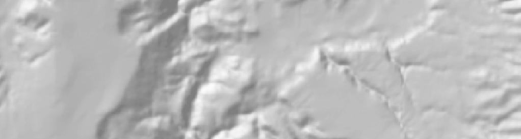
 ETM+ LANDSAT IMAGE")
5 NONO GUAYLLABAMBA CAYAMBE NONO GUAYLLABAMBA NONO GUAYLLABAMBA CAYAMBE QUITO QUITO QUITO ANTISANA ANTISANA ANTISANA COTOPAXI Kilom eters Miles Bands 7,5,4 (30m pixel resolution) COTOPAXI Bands 6 (90m pixel resolution) ETM+ LANDSAT IMAGE DEM
6 FLOWCHART 1. DOWNLOAD DATA AND PRE-PROCESSING DIGITAL ELEVATION MODEL (50m) Marc Souris IRD website ETM+ LANDSAT IMAGE (Bands 1,2,3,4,5,6 & 7) Global Land Cover Facility GEOLOGY/HYDROGEOLOGY (Faults and Well Inventory) Ecuador National Institute of Hydrology and Meteorology (1) DEM Layer 3) Composite Bands Layer (6) FAULTS Layer (2) HILLSHADE Layer (4) PCA Layer ( PC1, PC2 & PC3) (7) SPRINGS Layer (5) RADIANCE Layer

 6.698 9.1 7.35 7.79 9.55 10.05 8.24 8.69 10.71 12.")
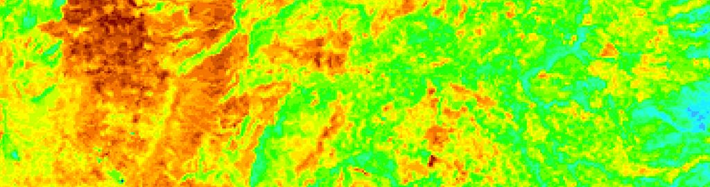
7 NONO GUAYLLABAMBA CAYAMBE NONO GUAYLLABAMBA CAYAMBE QUITO QUITO ANTISANA ANTISANA COTOPAXI COTOPAXI Kilometers Legend Radiance watts/(m2 ster µm)
8 2. PROCESSING DATA 2.1 CREATION OF LINEAMENTS MAP 2.2 IDENTIFICATION OF GROUNDWATER RECHARGE AREAS 2.2 IDENTIFICATION OF GROUNDWATER DISCHARGE AREAS IDENTIFICATION OF LINEAR FEATURES ON (1) DEM (Topography) (2) HILLSHADE (Topography) (3) PCA (Geological structures) (4) 4,3,2 Composite Landsat (6) Faults Layer OVERLAY (8) LINEAMENTS MAP (5) RADIANCE MAP OVERLAY (8) LINEAMENTS MAP WITH (5) RADIANCE MAP OVERLAY (5) RADIANCE MAP (7) SPRINGS LAYER DIGITIZING LINEAMENTS FOUN ON SEVERAL LAYERS CLASIFICATION OF LINEAMENTS AS POTENTIAL RECHARGE AREA** 1. There is a Lineament and 2. There are Low radiance values (in comparison to the surroundings) 3. Assign a field value as potential for recharge CLASIFICATION OF LINEAMENTS AS POTENTIAL DISCHARGE AREA 1. There is a Lineament and 2. There are High radiance values (in comparison to the surroundings) 3. Assign a field value as no potential for rechargel CLASIFICATION OF AREAS AS POTENTIAL DISCHARGE ` AREA 1. There is a spring of a group of springs 2. There are High radiance values (in comparison to the surroundings) ( 8) LINEAMENTS LAYER GENERATION OF RECHARGE ZONES 1. Buffer of 300m. (for Lineaments classified as potential recharge areas 2. Dissolve (to create non overlapping polygons) DIGITIZE THE POLYGON ON DISCHARGE SHP FILE ( 9) RECHARGE LAYER ( 10) DISCHARGE LAYER


9 Miles
10


11 Lineament Map NONO GUAYLLABAMBA CAYAMBE NONO GUAYLLABAMBA QUITO QUITO QUITO ANTISANA ANTISANA ANTISANA COTOPAXI COTOPAXI
")
12 MAP 6. POTENTIAL GROUNDWATER RECHARGE AND DISCHARGE ZONES OF QUITO AREA (BASED ON LINEAMENTS, SPRINGS AND THERMAL IMAGERY) NONO CAYAMBE GUAYLLABAMBA QUITO Legend ANTISANA cities volcanoes Springs Discharge areas Recharge areas COTOPAXI
13 CONCLUSIONS Landsat Imagery, Principal Component Analysis and DEM are very useful tools to identify geologic/geomorphologic lineaments. Thermal Imagery (Reflectance) shows a very interesting correlation with mapped lineaments. This map could be used as an orientation of future works to prove the assumption of lineaments/fractures acting as recharge/discharge areas. Fracturing is an important factor in the geologic conditions of Quito Area and further work should be done to characterize it in terms of the potential for groundwater resources.
14 Creating a Composite Map for Use in Selection of Possible Sites for New Well Placement near Quito, Ecuador ROB HEGEMANN

15 Combine: Existing well locations Lineament locations Map of porosity derived from geologic map km mi
16 Well and Lineament Locations km mi km mi

17 Porosity Map (Digitized Geology) Geologic units were classified based on description as: No Porosity Primary Porosity Secondary Porosity km mi
18 2. PROCESSING DATA 2.2 Conversion to raster (pixel size 1000m x1000m) Lineament Layer Well Layer Geology Layer Lineament Raster Well Raster Geology Raster Lineament Raster Well Raster Geology Porosity Raster Lineament: No Data (0) All values (10) Wells: No Data (0) All values (1) Geology: Primary porosity (100) Secondary porosity (200) No porosity (0) 2.3 Reclassify Values 3. PRODUCTION OF COMPOSITE MAP FOR GROUNDWATER POTENTIAL Lineament Raster Well Raster Geology Raster 3.1 Raster Calculator Sum raster values Composite Raster

19 Composite Map Quito No Porosity No Porosity, Wells No Porosity,Lineaments No Porosity, Lineaments, Wells Primary Porosity Primary Porosity, Wells Primary Porosity, Lineaments Primary Porosity, Lineaments, Wells Secondary Porosity Secondary Porosity, Wells Secondary Porosity, Lineaments Secondary Porosity, Lineaments, Wells km mi
A Remote Sensing Approach to Characterize the Hydrogeology of Mountainous Areas: Application to the Quito Aquifer System (QAS), Ecuador
, Ecuador") A Remote Sensing Approach to Characterize the Hydrogeology of Mountainous Areas: Application to the Quito Aquifer System (QAS), Ecuador Dissertation Research Proposal PIRE 0530109 Miriam Rios Sánchez July
A Remote Sensing Approach to Characterize the Hydrogeology of Mountainous Areas: Application to the Quito Aquifer System (QAS), Ecuador Dissertation Research Proposal PIRE 0530109 Miriam Rios Sánchez July
Outcrop suitability analysis of blueschists within the Dry Lakes region of the Condrey Mountain Window, North-central Klamaths, Northern California
 Outcrop suitability analysis of blueschists within the Dry Lakes region of the Condrey Mountain Window, North-central Klamaths, Northern California (1) Introduction: This project proposes to assess the
Mapping of Selected Important Bird Areas near Quito, Ecuador
 Mapping of Selected Important Bird Areas near Quito, Ecuador By Orfa Rodriguez, Peter Morrison and Hans Smith December 2003 Introduction and Justification The Important Bird Area (IBA) program is a global
USING GIS CARTOGRAPHIC MODELING TO ANALYSIS SPATIAL DISTRIBUTION OF LANDSLIDE SENSITIVE AREAS IN YANGMINGSHAN NATIONAL PARK, TAIWAN
 CO-145 USING GIS CARTOGRAPHIC MODELING TO ANALYSIS SPATIAL DISTRIBUTION OF LANDSLIDE SENSITIVE AREAS IN YANGMINGSHAN NATIONAL PARK, TAIWAN DING Y.C. Chinese Culture University., TAIPEI, TAIWAN, PROVINCE
Raster Analysis: An Example
 Raster Analysis: An Example Fires (1 or 4) Slope (1-4) + Geology (1-4) Erosion Ranking (3-12) 1 Typical Raster Model Types: Suitability Modeling: Where is optimum location? Distance Modeling: What is the
Raster Analysis; A Yellowstone Example 3/29/2018
 Fires (1 or 4) Typical Raster Model Types: Raster Analysis: An Example Suitability Modeling: Where is optimum location? Distance Modeling: What is the most efficient path from A to B? + Slope (1-4) Geology
Raster Analysis; A Yellowstone Example 10/24/2013. M. Helper GEO327G/386G, UT Austin 2. M. Helper GEO327G/386G, UT Austin 4
 + Fires (1 or 4) Slope (1-4) Geology (1-4) Erosion Ranking (3-12) Raster Analysis: An Example Typical Raster Model Types: Suitability Modeling: Where is optimum location? Distance Modeling: What is the
2013 Esri Europe, Middle East and Africa User Conference October 23-25, 2013 Munich, Germany
 2013 Esri Europe, Middle East and Africa User Conference October 23-25, 2013 Munich, Germany Environmental and Disaster Management System in the Valles Altos Region in Carabobo / NW-Venezuela Prof.Dr.habil.Barbara
Display data in a map-like format so that geographic patterns and interrelationships are visible
 Vilmaliz Rodríguez Guzmán M.S. Student, Department of Geology University of Puerto Rico at Mayagüez Remote Sensing and Geographic Information Systems (GIS) Reference: James B. Campbell. Introduction to
Raster Analysis: An Example
 Raster Analysis: An Example Fires (1 or 4) Slope (1-4) + Geology (1-4) Erosion Ranking (3-12) 11/8/2016 GEO327G/386G, UT Austin 1 Typical Raster Model Types: Suitability Modeling: Where is optimum location?
Remote sensing, GIS and groundwater exploration
 Remote sensing, GIS and groundwater exploration Geraint Burrows CEO of Groundwater Relief 4 th United Nations / Pakistan / Prince Sultan Bin Abdulaziz International Prize for Water International Conference
Geo-hazard Potential Mapping Using GIS and Artificial Intelligence
 Geo-hazard Potential Mapping Using GIS and Artificial Intelligence Theoretical Background and Uses Case from Namibia Andreas Knobloch 1, Dr Andreas Barth 1, Ellen Dickmayer 1, Israel Hasheela 2, Andreas
Groundwater. (x 1000 km 3 /y) Reservoirs. Oceans Cover >70% of Surface. Groundwater and the. Hydrologic Cycle
 Reservoirs. Oceans Cover >70% of Surface. Groundwater and the. Hydrologic Cycle") Chapter 13 Oceans Cover >70% of Surface Groundwater and the Hydrologic Cycle Oceans are only 0.025% of Mass Groundwater Groundwater is liquid water that lies in the subsurface in fractures in rocks and
Chapter 13 Oceans Cover >70% of Surface Groundwater and the Hydrologic Cycle Oceans are only 0.025% of Mass Groundwater Groundwater is liquid water that lies in the subsurface in fractures in rocks and
Geo 327G Semester Project. Landslide Suitability Assessment of Olympic National Park, WA. Fall Shane Lewis
 Geo 327G Semester Project Landslide Suitability Assessment of Olympic National Park, WA Fall 2011 Shane Lewis 1 I. Problem Landslides cause millions of dollars of damage nationally every year, and are
Louisiana Transportation Engineering Conference. Monday, February 12, 2007
 Louisiana Transportation Engineering Conference Monday, February 12, 2007 Agenda Project Background Goal of EIS Why Use GIS? What is GIS? How used on this Project Other site selection tools I-69 Corridor
GEO 327G Fall 2016 Project: Expansion of the Columbia South Shore Well Field
 GEO 327G Fall 2016 Project: Expansion of the Columbia South Shore Well Field Problem: If the Portland, OR surface water supply is rendered useless by turbidity or another natural event, then the Columbia
Delineation of Groundwater Potential Zone on Brantas Groundwater Basin
 Delineation of Groundwater Potential Zone on Brantas Groundwater Basin Andi Rachman Putra 1, Ali Masduqi 2 1,2 Departement of Environmental Engineering, Sepuluh Nopember Institute of Technology, Indonesia
Assessment of the Incidence of Landslides Using Numerical Information
 PAPER Assessment of the Incidence of Landslides Using Numerical Information Atsushi HASEGAWA Takehiro OHTA, Dr. Sci. Assistant Senior Researcher, Senior Researcher, Laboratory Head, Geology Laboratory,
INTERNATIONAL JOURNAL OF GEOMATICS AND GEOSCIENCES Volume 1, No 3, 2010
 Integrated approach using RS and GIS techniques for mapping of ground water prospects in Lower Sanjai Watershed, Jharkhand Binay Kumar 1, Uday Kumar 2 1 Geomatics Solutions Development Group, Centre for
Land Cover and Soil Properties of the San Marcos Subbasin
 Land Cover and Soil Properties of the San Marcos Subbasin Cody McCann EWRE Graduate Studies December 6, 2012 Table of Contents Project Background............................................................
Assessment of groundwater potential zones in Allahabad district by using remote sensing & GIS techniques
 2015; 1(13): 586-591 ISSN Print: 2394-7500 ISSN Online: 2394-5869 Impact Factor: 5.2 IJAR 2015; 1(13): 586-591 www.allresearchjournal.com Received: 21-10-2015 Accepted: 22-11-2015 Qazi Syed Wamiq Ali Sciences
GEOMATICS FOR MAPPING OF GROUNDWATER POTENTIAL ZONES IN NORTHERN PART OF THE UNITED ARAB EMIRATIS - SHARJAH CITY
 GEOMATICS FOR MAPPING OF GROUNDWATER POTENTIAL ZONES IN NORTHERN PART OF THE UNITED ARAB EMIRATIS - SHARJAH CITY R. AL-Ruzouq*, A. Shanableh and T. Merabtene University of Sharjah, Departmrnt of Civil
Erosion Susceptibility in the area Around the Okanogan Fire Complex, Washington, US
 Erosion Susceptibility in the area Around the Okanogan Fire Complex, Washington, US 1. Problem Construct a raster that represents susceptibility to erosion based on lithology, slope, cover type, burned
Alaska, USA. Sam Robbins
 Using ArcGIS to determine erosion susceptibility within Denali National Park, Alaska, USA Sam Robbins Introduction Denali National Park is six million acres of wild land with only one road and one road
Chapter Overview. Bathymetry. Measuring Bathymetry. Measuring Bathymetry
 CHAPTER 3 Marine Provinces Chapter Overview The study of bathymetry determines ocean depths and ocean floor topography. Echo sounding and satellites are efficient bathymetric tools. Most ocean floor features
Use of ArcGIS Applications for Analysis and Representation of the Terrains: The Case Study of Alakır River Sub-basin
 Use of ArcGIS Applications for Analysis and Representation of the Terrains: The Case Study of Alakır River Sub-basin Ahmet BENLİAY, Tahsin YILMAZ and H. Ekin OKTAY 1 Introduction 3D visualizations have
Creating Watersheds from a DEM
 Creating Watersheds from a DEM These instructions enable you to create watersheds of specified area using a good quality Digital Elevation Model (DEM) in ArcGIS 8.1. The modeling is performed in ArcMap
Introduction-Overview. Why use a GIS? What can a GIS do? Spatial (coordinate) data model Relational (tabular) data model
 data model Relational (tabular) data model") Introduction-Overview Why use a GIS? What can a GIS do? How does a GIS work? GIS definitions Spatial (coordinate) data model Relational (tabular) data model intro_gis.ppt 1 Why use a GIS? An extension
Introduction-Overview Why use a GIS? What can a GIS do? How does a GIS work? GIS definitions Spatial (coordinate) data model Relational (tabular) data model intro_gis.ppt 1 Why use a GIS? An extension
Location Suitability Analysis
 2010 Fall 406 Final Project Location Suitability Analysis New Burger stores in San Fernando Valley Presenter: Rich Lee I. Introduction In-N-Out Burger is famous in South West America. Established in 1948
+ = Spatial Analysis of Raster Data. 2 =Fault in shale 3 = Fault in limestone 4 = no Fault, shale 5 = no Fault, limestone. 2 = fault 4 = no fault
 Spatial Analysis of Raster Data 0 0 1 1 0 0 1 1 1 0 1 1 1 1 1 1 2 4 4 4 2 4 4 2 4 4 4 2 4 4 2 4 4 3 4 4 4 2 3 + = 0 = shale 1 = limestone 2 = fault 4 = no fault 2 =Fault in shale 3 = Fault in limestone
1 Oil Exploration and Production Authority, Ministry of Petroleum, Sudan 2 Faculty of Petroleum and Minerals, Al Neelain University, Khartoum, Sudan
 The Identification Of The Surface Phenomena Behind The Bad Acquired Seismic Data Through The Use Of Remote Sensing And GIS Techniques, Shelungo Area, Block-4, Muglad Basin, South Kordofan State, Sudan.
Groundwater Exploration using Integration of Electrical Resistivity Data with Remote Sensing and GIS Data, Northern State Sudan
 736 Groundwater Exploration using Integration of Electrical Resistivity Data with Remote Sensing and GIS Data, Northern State Sudan Dafalla Siddig Dafalla Department of Geology Email: wadiadam@gmail.com
MODULE 7 LECTURE NOTES 5 DRAINAGE PATTERN AND CATCHMENT AREA DELINEATION
 MODULE 7 LECTURE NOTES 5 DRAINAGE PATTERN AND CATCHMENT AREA DELINEATION 1. Introduction Topography of the river basin plays an important role in hydrologic modelling, by providing information on different
Czech Geological Survey Remote sensing unit
 Czech Geological Survey Remote sensing unit CGS Remote sensing unit Who we are? Part of the Dpt. of Regional geology of crystalline complexes Since 2005 Processing of satellite and airborne data Geoinformation
9-25. Sediment in Massai Steppe. Lake Natron, Lake Eyasi, Lake Manyara, Bahi swamp, part of Bubu river Purple. Purple-red Saline lake, swamp
 9.5 Productivity Analysis and Hydrogeological Map 9.5.1 Productivity Analysis Productivity distribution of groundwater was presumed by the geological condition, yield of existing wells, rainfall, topographic
Surface Processes Focus on Mass Wasting (Chapter 10)
") Surface Processes Focus on Mass Wasting (Chapter 10) 1. What is the distinction between weathering, mass wasting, and erosion? 2. What is the controlling force in mass wasting? What force provides resistance?
Surface Processes Focus on Mass Wasting (Chapter 10) 1. What is the distinction between weathering, mass wasting, and erosion? 2. What is the controlling force in mass wasting? What force provides resistance?
Spatial Analysis of Raster Data
 Spatial Analysis of Raster Data 0 0 1 1 0 0 1 1 1 0 1 1 1 1 1 1 2 4 4 4 2 4 5 5 4 2 4 4 4 2 5 5 4 4 2 4 5 4 3 5 4 4 4 2 5 5 5 3 + = 0 = shale 1 = limestone 2 = fault 4 = no fault 2 =Fault in shale 3 =
ESRI GIS For Mining Seminar, 10 th August, 2016, Nairobi, Kenya. Spatial DATA Solutions for Mining
 ESRI GIS For Mining Seminar, 10 th August, 2016, Nairobi, Kenya Spatial DATA Solutions for Mining Spatial Data Solutions for Mining Spatial - Data that identifies the geographic location of features &
Chapter 14: Groundwater. Fig 14.5b
 Chapter 14: Groundwater Fig 14.5b OBJECTIVES Recognize that groundwater is a vital source of accessible freshwater. Describe how groundwater forms below the water table. Explain the origin of aquifers,
Gravity and Magnetic Anomalies Compared to Moho Depth throughout the State of Texas
 Gravity and Magnetic Anomalies Compared to Moho Depth throughout the State of Texas Taylor Borgfeldt Introduction My Master s thesis is to improve and create additional crustal seismic velocity models
Ground Water in the Piedmont and Blue Ridge
 engineering earth's development preserving earth's integrity Engineering Earth s Development Preserving Earth s Integrity Ground Water in the Piedmont and Blue Ridge Jim Renner Acknowledgements Contributors:
Interpretive Map Series 24
 Oregon Department of Geology and Mineral Industries Interpretive Map Series 24 Geologic Hazards, and Hazard Maps, and Future Damage Estimates for Six Counties in the Mid/Southern Willamette Valley Including
Integrated Remote Sensing and GIS Approach for Groundwater Exploration using Analytic Hierarchy Process (AHP) Technique.
 Technique.") ISSN (Online) : 2319-8753 ISSN (Print) : 2347-6710 International Journal of Innovative Research in Science, Engineering and Technology An ISO 3297: 2007 Certified Organization, Volume 2, Special Issue
ISSN (Online) : 2319-8753 ISSN (Print) : 2347-6710 International Journal of Innovative Research in Science, Engineering and Technology An ISO 3297: 2007 Certified Organization, Volume 2, Special Issue
Volcanic Hazards of Mt Shasta
 Volcanic Hazards of Mt Shasta Introduction Mt Shasta is a volcano in the northern part of California. Although it has been recently inactive for over 10,000 years. However, its eruption would cause damage
Required Materials Plummer, C., Physical geology. Columbus, OH: McGraw Hill Higher Education
 Butler Community College Science, Technology, Engineering, and Math Division Robert Carlson Revised Fall 2017 Implemented Spring 2018 Textbook Update Spring 2018 COURSE OUTLINE Physical Geology Course
11/22/2010. Groundwater in Unconsolidated Deposits. Alluvial (fluvial) deposits. - consist of gravel, sand, silt and clay
 deposits. - consist of gravel, sand, silt and clay") Groundwater in Unconsolidated Deposits Alluvial (fluvial) deposits - consist of gravel, sand, silt and clay - laid down by physical processes in rivers and flood plains - major sources for water supplies
Groundwater in Unconsolidated Deposits Alluvial (fluvial) deposits - consist of gravel, sand, silt and clay - laid down by physical processes in rivers and flood plains - major sources for water supplies
Remote Sensing and GIS Applications for Hilly Watersheds SUBASHISA DUTTA DEPARTMENT OF CIVIL ENGINEERING IIT GUWAHATI
 Remote Sensing and GIS Applications for Hilly Watersheds SUBASHISA DUTTA DEPARTMENT OF CIVIL ENGINEERING IIT GUWAHATI Deciding Alternative Land Use Options in a Watershed Using GIS Source: Anita Prakash
Pipeline Routing Using Geospatial Information System Analysis
 Pipeline Routing Using Geospatial Information System Analysis Mahmoud Reza 1 Delavar and Fereydoon 2 Naghibi 1-Assistance Professor, Dept. of Surveying and Geomatic Eng., Eng. Faculty, University of Tehran,
Fire Susceptibility Analysis Carson National Forest New Mexico. Can a geographic information system (GIS) be used to analyze the susceptibility of
 be used to analyze the susceptibility of") 1 David Werth Fire Susceptibility Analysis Carson National Forest New Mexico Can a geographic information system (GIS) be used to analyze the susceptibility of Carson National Forest, New Mexico to forest
1 David Werth Fire Susceptibility Analysis Carson National Forest New Mexico Can a geographic information system (GIS) be used to analyze the susceptibility of Carson National Forest, New Mexico to forest
PROANA A USEFUL SOFTWARE FOR TERRAIN ANALYSIS AND GEOENVIRONMENTAL APPLICATIONS STUDY CASE ON THE GEODYNAMIC EVOLUTION OF ARGOLIS PENINSULA, GREECE.
 PROANA A USEFUL SOFTWARE FOR TERRAIN ANALYSIS AND GEOENVIRONMENTAL APPLICATIONS STUDY CASE ON THE GEODYNAMIC EVOLUTION OF ARGOLIS PENINSULA, GREECE. Spyridoula Vassilopoulou * Institute of Cartography
B. T. Brady, M. S. Bedinger, John Mikels, William H. Langer, and Deborah A. Mulvihill
 DEPARTMENT OF THE INTERIOR UNITED STATES GEOLOGICAL SURVEY TO ACCOMPANY WRI REPORT 83-4121-B MAP SHOWING GROUND-WATER LEVELS, SPRINGS. AND DEPTH TO GROUND WATER, BASIN AND RANGE PROVINCE, TEXAS by B. T.
Lineaments Analysis to Identify Favourable Areas for Groundwater in Kano City, Northwestern Nigeria
 Lineaments Analysis to Identify Favourable Areas for Groundwater in Kano City, Northwestern Nigeria Tahir A.G. Garba M. L. Hassan C. Department of Geology, Ahmadu Bello University Zaria, Nigeria E-mail:
Determining the Location of the Simav Fault
 Lindsey German May 3, 2012 Determining the Location of the Simav Fault 1. Introduction and Problem Formulation: The issue I will be focusing on involves interpreting the location of the Simav fault in
Integrated GIS based approach in mapping the groundwater potential zones in Kota Kinabalu, Sabah, Malaysia
 Integrated GIS based approach in mapping the groundwater potential zones in Kota Kinabalu, Sabah, Malaysia Zulherry Isnain and Juhari Mat Akhir Faculty of Science and Natural Resources, Universiti Malaysia
An experience with ILWIS in connection with National Geochemical Mapping by Geological Survey of India
 An experience with ILWIS in connection with National Geochemical Mapping by Geological Survey of India 1 S. Ramamurthy Geodata Division, Eastern Region, Geological Survey of India, Dk-6, Sector-2, Kolkata-91(ramasoma@yahoo.com)
Groundwater Hydrology
 EXERCISE 12 Groundwater Hydrology INTRODUCTION Groundwater is an important component of the hydrologic cycle. It feeds lakes, rivers, wetlands, and reservoirs; it supplies water for domestic, municipal,
The Favorability of Florida s Geology to Sinkhole Formation
 Florida Geological Survey The Favorability of Florida s Geology to Sinkhole Formation Clint Kromhout Alan Baker October 24, 2017 Subsidence Report Database Map of Subsidence Incident Reports taken from
Watershed Delineation
 Foundations of Physical Hydrology Watershed Delineation Contact information: Jack Hermance Environmental Geophysics/Hydrology Department of Geological Sciences Brown University, Providence, RI 02912-1846
Pierce Cedar Creek Institute GIS Development Final Report. Grand Valley State University
 Pierce Cedar Creek Institute GIS Development Final Report Grand Valley State University Major Goals of Project The two primary goals of the project were to provide Matt VanPortfliet, GVSU student, the
Bonn, Germany MOUTAZ DALATI. General Organization for Remote Sensing ( GORS ), Syria Advisor to the General Director of GORS,
, Syria Advisor to the General Director of GORS,") Bonn, Germany Early Warning System is needed for Earthquakes disaster mitigation in Syria Case Study: Detecting and Monitoring the Active faulting zones along the Afro-Arabian-Syrian Rift System MOUTAZ
Bonn, Germany Early Warning System is needed for Earthquakes disaster mitigation in Syria Case Study: Detecting and Monitoring the Active faulting zones along the Afro-Arabian-Syrian Rift System MOUTAZ
Sea Level Scare in South Carolina. by William Witmer GEO 327G 5 December 2016
 Sea Level Scare in South Carolina by William Witmer GEO 327G 5 December 2016 Problem Hilton Head Island in South Carolina attracts 2.5 million tourists every year. This popular locale features endangered
Bathymetry Measures the vertical distance from the ocean surface to mountains, valleys, plains, and other sea floor features
 1 2 3 4 5 6 7 8 9 10 11 CHAPTER 3 Marine Provinces Chapter Overview The study of bathymetry determines ocean depths and ocean floor topography. Echo sounding and satellites are efficient bathymetric tools.
Using LiDAR as an Oil and Natural Gas Exploration Tool
 Figure 1: The Face of the Matanuska Glacier outside of Palmer Alaska. The Matanuska is a good example of a small retreating alpine glacier. Fractures in the glacier allow meltwater to carry rock and sediment
Georeferencing the Lackawanna Synclinorium using GIS
 Georeferencing the Lackawanna Synclinorium using GIS Conservation Services, LLC 2/20/2010 Contact: Philip Pass 570.510.1758 Rick Marquardt 570-335-7525 Managing Partners: Conservation Services LLC Author:
Final Project: Geodatabase of Mule Mountains Area, southeastern Arizona
 R. Aisner 11/24/09 GEO 386G Final Project: Geodatabase of Mule Mountains Area, southeastern Arizona Project goal: Develop a geodatabase with vector and raster data for future data organization and analysis.
INTERNATIONAL JOURNAL OF GEOMATICS AND GEOSCIENCES Volume 3, No 1, 2012
 INTERNATIONAL JOURNAL OF GEOMATICS AND GEOSCIENCES Volume 3, No 1, 2012 Copyright by the authors - Licensee IPA- Under Creative Commons license 3.0 Research article ISSN 0976 4380 Geo-Hydrological study
Earth Science. Explain how Earth's biogeochemical cycles create a balance of materials. Examine the importance of biogeochemical cycles.
 Unit 1: DYNAMIC STRUCTURE OF EARTH Introduction to Understand that earth science is based upon the four sciences of astronomy, geology, meteorology, and oceanography. Identify topics studied within the
Landslide Susceptibility, Hazard, and Risk Assessment. Twin Hosea W. K. Advisor: Prof. C.T. Lee
 Landslide Susceptibility, Hazard, and Risk Assessment Twin Hosea W. K. Advisor: Prof. C.T. Lee Date: 2018/05/24 1 OUTLINE INTRODUCTION LANDSLIDE HAZARD ASSESSTMENT LOGISTIC REGRESSION IN LSA STUDY CASE
Volcanic Hazard Assessment of Southern Iceland Helper, GIS 327G
 Raeann Garcia 05/03/2018 Volcanic Hazard Assessment of Southern Iceland Helper, GIS 327G Introduction: Iceland is an island nation far in the northern hemisphere, with a portion of the country included
Mark S. Nordberg Geology and Groundwater Investigations Section North Central Region Office California Department of Water Resources
 Mark S. Nordberg Geology and Groundwater Investigations Section North Central Region Office California Department of Water Resources Ukiah Drought Workshop July 29, 2009 Groundwater 101 Groundwater is
ASTER DEM Based Studies for Geological and Geomorphological Investigation in and around Gola block, Ramgarh District, Jharkhand, India
 International Journal of Scientific & Engineering Research, Volume 3, Issue 2, February-2012 1 ASTER DEM Based Studies for Geological and Geomorphological Investigation in and around Gola block, Ramgarh
Watershed Delineation
 Watershed Delineation Jessica L. Watkins, University of Georgia 2 April 2009 Updated by KC Love February 25, 2011 PURPOSE For this project, I delineated watersheds for the Coweeta synoptic sampling area
GED 554 IT & GIS INTRODUCTION TO THE COURSE CHAPTER 1
 GED 554 IT & GIS INTRODUCTION TO THE COURSE CHAPTER 1 March 1, 2013 Lines before starting class 1. Initial Introductions 2. Usage of the building 3. Assistance 4. Timetable 5. Curriculum 6. Introduction
Springshed Springshed Management Training Curriculum
 Springshed Springshed Management Training Curriculum Management Training Curriculum Draft Version 2 January 2016 The Springs Initiative 2016 The Springs Initiative SESSION TITLE: Section Mapping SECTION:
Technical Requirements of Geothermal Exploration in the RSM DADI THORBJORNSON, RSM CONSULTANT WORKSHOP SWISS HOTEL IZMIR 5 JULY 2018
 Technical Requirements of Geothermal Exploration in the RSM DADI THORBJORNSON, RSM CONSULTANT WORKSHOP SWISS HOTEL IZMIR 5 JULY 2018 JV Partners Engineering firm with hundred twenty years of experience
Using MODIS imagery to validate the spatial representation of snow cover extent obtained from SWAT in a data-scarce Chilean Andean watershed
 Using MODIS imagery to validate the spatial representation of snow cover extent obtained from SWAT in a data-scarce Chilean Andean watershed Alejandra Stehr 1, Oscar Link 2, Mauricio Aguayo 1 1 Centro
Application of Thermal Remote Sensing for Geothermal Mapping, Lake Naivasha, Kenya
 Proceedings World Geothermal Congress 2010 Bali, Indonesia, 25-29 April 2010 Application of Thermal Remote Sensing for Geothermal Mapping, Lake Naivasha, Kenya Michael S. Pastor Geothermal and Coal Resources
Southern Gulf Islands, British Columbia. Ministry of Forests Lands and Natural Resource Operations West Coast Region, Nanaimo, British Columbia
 Comparison of DRASTIC and DRASTIC-Fm methodologies for evaluation of intrinsic susceptibility of coastal bedrock aquifers and the adjustment of DRASTIC-Fm Fractured Media parameter Southern Gulf Islands,
Favorable potential zone map using Remote sensing and GIS
 Favorable potential zone map using Remote sensing and GIS M. Devarajan & S.Mohan GIS Cell, Hydrogeology Wing Tamilnadu Water Supply and Drainage Board, Chennai Abstract: TWAD Board is shouldering the responsibility
Groundwater. (x 1000 km 3 /y) Oceans Cover >70% of Surface. Groundwater and the. Hydrologic Cycle
 Oceans Cover >70% of Surface. Groundwater and the. Hydrologic Cycle") Chapter 17 Oceans Cover >70% of Surface Groundwater and the Hydrologic Cycle Vasey s Paradise, GCNP Oceans are only 0.025% of Mass Groundwater Groundwater is liquid water that lies in the subsurface in
Chapter 17 Oceans Cover >70% of Surface Groundwater and the Hydrologic Cycle Vasey s Paradise, GCNP Oceans are only 0.025% of Mass Groundwater Groundwater is liquid water that lies in the subsurface in
GOVERNMENT OF NEPAL MINISTRY OF IRRIGATION GROUND WATER RESOURCES DEVELOPMENT BOARD BABARMAHAL, KATHMANDU, NEPAL
 GOVERNMENT OF NEPAL MINISTRY OF IRRIGATION GROUND WATER RESOURCES DEVELOPMENT BOARD BABARMAHAL, KATHMANDU, NEPAL GIS Based Updating of Groundwater Level Siraha District Final Report Submitted to Ground
Assessment of Urban Geomorphological Hazard in the North-East of Cairo City, Using Remote Sensing and GIS Techniques. G. Albayomi
 Assessment of Urban Geomorphological Hazard in the North-East of Cairo City, Using Remote Sensing and GIS Techniques G. Albayomi Geography Department, Faculty of Arts, Helwan University, Cairo, Egypt Gehan_albayomi@arts.helwan.edu.eg
Science. Smyth County Schools Curriculum Map Grade:9 Subject:Earth Science I
 Standards 1st Quarter Grade:9 Subject:Earth I ES.1 The student will plan and conduct investigations in which a) volume, area, mass, elapsed time, direction, temperature, pressure, distance, density, and
Spatio-temporal models
 Spatio-temporal models Involve a least a three dimensional representation of one or more key attribute variation in planar (X-Y) space and through time. (a 4 th dimension could also be use, like Z for
a system for input, storage, manipulation, and output of geographic information. GIS combines software with hardware,
 Introduction to GIS Dr. Pranjit Kr. Sarma Assistant Professor Department of Geography Mangaldi College Mobile: +91 94357 04398 What is a GIS a system for input, storage, manipulation, and output of geographic
Delineation of high landslide risk areas as a result of land cover, slope, and geology in San Mateo County, California
 Delineation of high landslide risk areas as a result of land cover, slope, and geology in San Mateo County, California Introduction Problem Overview This project attempts to delineate the high-risk areas
1. Introduction. Jai Kumar, Paras Talwar and Krishna A.P. Department of Remote Sensing, Birla Institute of Technology, Ranchi, Jharkhand, India
 Cloud Publications International Journal of Advanced Remote Sensing and GIS 2015, Volume 4, Issue 1, pp. 1026-1032, Article ID Tech-393 ISSN 2320-0243 Research Article Open Access Forest Canopy Density
Lecture 3. Data Sources for GIS in Water Resources
 Lecture 3 Data Sources for GIS in Water Resources GIS in Water Resources Spring 2015 http://www.data.gov/ 1 USGS GIS data for Water http://water.usgs.gov/maps.html Watersheds of the US 2-digit water resource
GROUNDWATER OCCURRENCE IN KENYA
 GROUNDWATER OCCURRENCE IN KENYA Steven Okoth Owuor Ministry of Water and Sanitation Sunday, January 20, 2019 1 Geography INTRODUCTION The Republic of Kenya is located in East Africa The total area of the
About the Author: Abstract:
 Identification of groundwater prospecting zones using Remote Sensing and GIS techniques in upper Vena river watersheds Nagpur district, Maharashtra, India B.S. Manjare Department of Geology RTM Nagpur
IPMO2-1. Groundwater Modelling of Chiang Rai Basin, Northern Thailand. Sattaya Intanum* Dr.Schradh Saenton**
 IPMO2-1 Groundwater Modelling of Chiang Rai Basin, Northern Thailand Sattaya Intanum* Dr.Schradh Saenton** ABSTRACT Chiang Rai basin, situated in Chiang Rai and Phayao provinces covering an area of 11,000
GEOSENSE - GEOLOGICAL MAPPING
 GEOSENSE - GEOLOGICAL MAPPING Whatever the terrain you re working in (from desert to arctic to tropical jungle), whatever the tectonic setting, Geosense has undertaken geological mapping in similar regions.
the Quarrying Industry Dewatering and the Quarrying Industry the Quarrying Industry
 Dewatering and the Quarrying Industry Dewatering and Dewatering and the Quarrying Industry the Quarrying Industry Les Brown Eugene P. Daly John Kelly Objectives 1) To present a summary of water management
Prof. Stephen A. Nelson EENS 111. Groundwater
 Page 1 of 8 Prof. Stephen A. Nelson EENS 111 Tulane University Physical Geology This page last updated on 20-Oct-2003 is water that exists in the pore spaces and fractures in rock and sediment beneath
GIS and Remote Sensing
 Spring School Land use and the vulnerability of socio-ecosystems to climate change: remote sensing and modelling techniques GIS and Remote Sensing Katerina Tzavella Project Researcher PhD candidate Technology
New Course Form. 1. Catalog Prefix and Number*: EST Course Title: Hydrologic Geology Lab. Pilot Course Information:
 57 New Course Form For help filling out the form press F1 or look at the bottom of the screen. For additional instructions, see Course Form Instructions. Type of Action New Course Course not previously
NR402 GIS Applications in Natural Resources
 NR402 GIS Applications in Natural Resources Lesson 1 Introduction to GIS Eva Strand, University of Idaho Map of the Pacific Northwest from http://www.or.blm.gov/gis/ Welcome to NR402 GIS Applications in
GEOLOGY CURRICULUM. Unit 1: Introduction to Geology
 Chariho Regional School District - Science Curriculum September, 2016 GEOLOGY CURRICULUM Unit 1: Introduction to Geology OVERVIEW Summary In this unit students will be introduced to the field of geology.
Hydrologic Modelling of the Upper Malaprabha Catchment using ArcView SWAT
 Hydrologic Modelling of the Upper Malaprabha Catchment using ArcView SWAT Technical briefs are short summaries of the models used in the project aimed at nontechnical readers. The aim of the PES India
Application of Weights of Evidence Method for Assessment of Flowing Wells in the Greater Toronto Area, Canada
 Natural Resources Research, Vol. 13, No. 2, June 2004 ( C 2004) Application of Weights of Evidence Method for Assessment of Flowing Wells in the Greater Toronto Area, Canada Qiuming Cheng 1,2 Received