An Exploration of the Use of Satellite Remote Sensing to Predict Extrusive Events on Colima Volcano Bruce Wahle ASEN 5235 April 24, 2003
|
|
|
- Agatha Houston
- 6 years ago
- Views:
Transcription
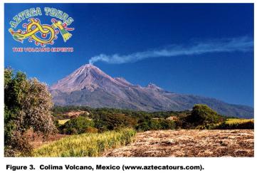
1 An Exploration of the Use of Satellite Remote Sensing to Predict Extrusive Events on Colima Volcano Bruce Wahle ASEN 5235 April 24, 2003 There are more than 1300 active volcanoes in the world (Stoiber 1995), and the majority of world s most dangerous volcanoes are not monitored at all (Chester 1993, Tilling 1993). As the Earth s population increases more people are living close to active volcanoes. Some of these volcanoes are isolated and remote sensing by satellite could be a cost efficient and rapid way to monitor and forecast their eruptive activity. Increasing concentrations of volcanic gases and/or their ratios (Menyailov 1975, Shimozuru 1983, Stoiber et al. 1983), and lava dome building have been suggested as precursors of eruptions (Luhr 2002). The purpose of this paper is: to explorer the ability of satellites to remotely identify pre-eruption sulfur dioxide (SO 2 ) flux changes; to explorer what are the satellite availability, cost and quality of the data; to look specifically at Colima Volcano, Mexico; with the intended goal of identifying a remote satellite system, that can measure volcanic gas changes of sulfur dioxide, rapidly and in a cost effective manner, in order to predict eruptive events in andesitic arc stratovolcanoes For this study, I wanted to look at Colima Volcano in Mexico. The area is at the juncture of three tectonic plates (Cocos, Rivera, North American, Figure 1); a large-scale earthquake occurred nearby on January 22, In the state of Jalisco, Mexico are two andesitic stratovolcanoes 4.8 km (3miles) apart: Colima Volcano (also known as Volcan de Colima and El Volcan de Fuego de Colima) and Nevado de Colima Volcano (Figure 2). Volcan Nevado de Colima is 4381 m (14,365 feet) tall, covered by coniferous forest, and is considered dormant. Colima Volcano at 3962 m (12,989) feet is considered the most dangerous volcano in Mexico (Figure 3, Luhr 1981). Colima Volcano is continually active and erupts frequently; it is one of North America s most active volcanoes (Moreno Pena and Salazar Silva 2002). Colima Volcano is a Quaternary volcano that is in an area that is both tectonically and seismically active, and the present cone has been growing for approximately 4000 years (Taran et al. 2002). In general, monitoring of SO 2 fluxes and potential eruption of volcanoes is important for a number of reasons. It is important from a public health/emergency-planning standpoint. The immediate danger from an eruption may endanger humans and livestock. In political failures to evacuate threatened cities there have been massive death counts, such as in St. Pierre, Martinique (~29,000) and Armero, Colombia (~25,000). On the other hand, predicting eruptions and evacuating populations have success stories, such as around Mt. Pinatubo, Philippines and
2 Mount St. Helens, USA. Long-term effects from ash fall may result in famine and death; the Laki fissure eruption in Iceland in 1783 caused the death of much of the island s livestock and approximate 20% of the island s human population from starvation (Chester 1993). The monitoring of ash and temperature changes is important because they are factors in atmospheric forcing. Increases in SO 2 flux will, over time, convert to sulfuric acid and sulfates. Sulfuric acid is one of the causes of acid rain, and sulfates contribute to atmospheric cooling and may affect the formation of cirrus clouds. Ozone destruction is another possible result from increased SO 2 atmospheric increases. The danger of aircraft flying into volcanic plumes is great, both in aircraft mechanical damage and plane crashes (Trebella 2002). More than 300,000 people are living near by Colima Volcano. Methods There are two basic types of volcanoes: arc and nonarc volcanoes. Arc volcanoes are located in areas of subduction zones. Eighty-one percent (429 of 530) of eruptions are in subduction-zone volcanoes (Simkin and Siebert 1984). Nonarc volcanoes are found over hotspots and rifts. Colima Volcano is an arc stratovolcano with andesitic (57-63% silica) lava, which makes the eruption more explosive, rather than effusive (Chester 1993). The general trend of Colima Volcano and other andesitic volcanoes like it is to undergo a cyclic process of a large eruption, filling back up again with lava, becoming plugged up again, sealing shut, and then another large eruption to clear the volcanic throat (Figure 4, Luhr 2002). As fresh magma begins to rise in a volcanic system, volcanic gases should become more prevalent in the volcanic plume. The major volcanic gases are: water vapor, carbon dioxide, SO 2, and hydrochloric acid mixed with other trace gases (Chester 1993, Williams and Montaigne 2001). With remote satellite measurements, water, carbon dioxide and ozone are confounders in the atmosphere and must be corrected for (Krueger 1983, Stoiber et al. 1986). For this reason, I 2

3 3
4 decided to concentrate on SO 2 measurements. As magma moves to the surface, more SO 2 should be detectable in the volcanic plume, up to the point where the lava dome becomes sealed, just before eruption. Unfortunately, not all volcanoes have high sulfur emissions (Schnetzler et al. 1997). Satellites and aircraft have done remote sensing volcanic monitoring by observing changes in thermal, volcanic ash and gaseous emissions. Airborne monitoring of SO 2 and sulfates has been carried out with the Thermal Infrared Multispectral Scanner (TIMS). Some of the satellite platforms or sensors, which have been used to monitor volcanic thermal, volcanic ash and/or SO2, are: Advanced Very High Resolution Radiometer (AVHRR) Geostationary Operational Environmental Satellite (GOES) Moderate Resolution Imaging Spectroradiometer (MODIS) Advanced Spaceborne Thermal Emission and Reflection Radiometer (ASTER) Total Ozone Mapping Spectrometer (TOMS) 4
. MODIS data, while free, still is too broad (pixels 240-1920 m) for this task.")
5 The AVHRR and GOES satellite have large area coverages and while good to monitor the volcanic eruption after the fact, they would not have the fine resolution to measure volcanoes pre-eruption (pixels m). MODIS data, while free, still is too broad (pixels m) for this task. ASTER data (pixels m) would be interesting to use, but it costs $55 per scene and its return time is too long (16 days). Based on spatial resolution ( m), cost and return time (1 day), TOMS was the only choice for this project. Data used in this study were downloaded from the Earth Probe TOMS V. 7 Internet site for the Guadalajara, Mexico station (site ID 654, elevation 1420 masl, generated March 9, 2003), approximately 128 km to the northwest of Colima Volcano. The TOMS sulfur dioxide index (SOI) from July 17, 1996 to March 8, 2003 was used for this study. Volcanic activities of Colima Volcano were identified from the numerous sources (Anon. 1999, 2001, 2002, 2003a, 2003b; Galindo and Dominguez 2002; Penick 2003). TOMS data was plotted in a spreadsheet software package. In addition to plotting the raw SOI versus time, I tried to normalize the data by calculating the percent difference from the previous measurement (usually 24 hours). Results SOI % Change = ((day 2 day 1)/day 1) x 100 All TOMS data downloaded were plotted in Figure 5. It is immediately apparent that there is a problem after August 1, 2001 (day 213). A sensor began to degrade and corrections were made to the instrument. Although NASA says this has been corrected (NASA 2003), I question this. 5

6 The upward swing just before the sensor correction is probably due to erroneous readings, rather than increasing SOI, in my opinion. Long-term trend analysis cannot be done until the database is corrected. Data after approximately January 2001 must be corrected before direct use of the SOI can be done because of the downward shift. Figure 6 shows the percent SOI change versus time for the years This was the beginning of another active eruption cycle on Colima Volcano. Beginning in mid-summer 1997 geochemistry values began to increase in the fumaroles. In November 1997 there was an eruption and seismic swarms on the cone. A large eruption was predicted and occurred in November 1998 (Zobin et al. 2002). Before the eruptions, the variation in the percent SOI change decreased. The events that began with large eruption on November 20, 1998 continued into Figure 7 shows the data plotted from November 1, 1998 to December 31, There were a number of eruptions during this time period, some minor and other major eruptions (November 20, 1998, February 10, 1999, May 10, 1999, July 17, 1999; Zobin et al. 2002). Once again SO 2 fluxes usually decrease before the eruption, but not always. One has to realize the eruption data has come from various sources and has not been collected first hand by the investigator. The general trend of SO 2 activity increasing previous to an eruptive event, then a decrease just prior to eruption follows the prediction of events. 6
.")
7 An idea that volcanic eruptions have a seasonality has been looked at in several studies. With larger databases, this has proven to be statistically valid for several volcanoes (Mason 2003). With the volcanic activity I was able to locate for Colima Volcano from November 21, 1997 to March 8, 2003, 51 volcanic events were identified (Figures 8 and 9, Table 1). Figure 8 is a plot of the count of events versus day of year over more than 5 years. Figure 9 shows the same data, but in a pie chart of counts per month. Table 1 represents the data from Figure 9, but in a more readable table format. The apparent seasonality of eruptions at Colima Volcano looks intriguing, but this represents a very small and incomplete database. Studies with much larger data sets and more rigorous statistics have been needed to show this on (some) volcanoes (see Mason 2003). Summary The purpose of this study was to investigate whether a remote sensing satellite could measure SO 2 concentrations in volcanic emissions prior to an eruption. Some volcanologists believe either SO 2 concentrations or a ratio of volcanic gases can forecast a volcanic eruption. The TOMS instrument measures SO 2 approximately daily for a number of sites worldwide. TOMS measures SO 2 at UV wavelengths during the daytime only. The first TOMS sensor detected 55 of the 350 known eruptions (16%, post eruption) between 1979 to 1992, and improved TOMS instruments were launched in lower orbits have detected SO 2 gas from smaller eruptions and passive volcanic degassing (USGS 2001). TOMS is best used to detect and track SO2 emitted from the explosive phase of eruptions; it observes SO 2 primarily in the stratosphere. The detection limit for TOMS was about 5 kilotons SO 2. Typical volcanic SO 2 clouds measured by TOMS are 20-several hundred Dobson Units (DU), with an error estimation of +/- 30% 7
.")
8 (Bluth et al. 1992). TOMS is ideal for large eruptions, but it cannot capture all eruptions, especially numerous low-level or non-explosive eruptions (Bluth et al. 1993, 1997). Total SO 2 values greater than 100 DU in the TOMS database are observed only in the first day of eruptions except for the largest eruptions (e.g., Mt. Pinatubo, El Chinchon). The maximum of SO 2 amounts extends to 600 DU (only rarely observed in very fresh plumes). Most plumes are less than 100 DU SO 2 (Krueger et al. 1995). Other limitations exists in accessing high latitude volcanic activity with TOMS in the winter because of decreased daylight hours, and longer path lengths due to low sun angles reducing precision of the SO 2 algorithm (Bluth et al. 1997). At near-nadir scan positions, a measurement change of 1 DU is caused by a little more than 50 tons SO 2 (Krueger et al. 1995). The TOMS site at Guadalajara, Mexico is approximately 128 km from Colima Volcano (2-6 pixels from nadir). This means that to capture a SO 2 emission, at least a reading of 9-10 DU must be observed. Two ground measuring spectrometers are utilized in volcano monitoring, a correlation spectrometer (COSPEC) and a Brewer spectrometer, for measuring total mass of gaseous eruptions. Attempts to correlate TOMS SO 2 retrievals with COSPEC have not met with success because they have vastly different sensitivities and they are not operating at same times. The attempts with the Brewer spectrophotometer were in good agreement when data were available on the same days (Krueger et al. 1995). Use of these 8
9 ground based instruments at the same time as the TOMS over flights would help to validate the TOMS data. Specifically looking at the andesitic Colima Volcano, COSPEC measurements from the air gave 320 +/- 50 metric tons/day while the volcano was quiescent. A comparison of SO 2 concentrations in plumes with ground fumarole gas samples suggests that the plumes are diluted by the atmosphere by factors of up to A COSPEC clean troposphere measurement gives values of ppb SO 2, while Colima Volcano had values of ppb SO 2. The lifetime of these quiescent plumes is short, probably hours to days, compared to the longer residence times of months to years of eruption plumes injected into the stratosphere (Casadevall et al. 1984). Quiescent volcanoes with noticeable vapor plumes emit on order of 10 2 tons SO 2 /day; volcanoes with small plumes emit an order of magnitude less (Stoiber and Jepsen 1973). SO 2 flux rates of 10 s to 1000 s of metric tons/day for a volcano producing very little or no solid products (non-eruptive) are seen. An erupting volcano, producing ash or lava, can produce 10 s to 1000 s of thousands of tons per day of SO 2 (Stoiber et al. 1983). TOMS is able to measure SO 2 concentrations, but not H 2 S or sulfates (McKeen et al. 1984) and probably not S 2, so the TOMS values would represent a minimum of sulfur products being released. There is a variation in gases depending on their release area on the volcano (e.g., main vent, associated lava flows, pyroclastic flows; Stoiber 1995). The SOI accurate measure of SO 2 for ash-free plumes is up to 100 DU, the SOI begins to lose some accuracy between DU and becomes unreliable >200 DU. The presence of ash causes the SOI to underestimate the SO 2 mass (Seftor et al. 1997). Andesite-producting volcanoes often penetrate the tropopause (Cadle 1975). Based on measurements from the quiescent Colima Volcanco and the sensitivity of the TOMS instrument, a warning SOI threshold in the area of 8-10 DU could be proposed to indicate above normal, quiescent SO 2 emissions from the volcano. On October 30 and November 16, 1998 COSPEC readings of 400 tons/day SO 2 presaged the plume of November 18, 1998, which resulted a record SO 2 flux measured at Colima Volcano of 1600 tons/day and the eruption of November 20, 1998 (Zobin et al. 2002). The problems that exist with study are that although the TOMS instrument may capture a volcano in its scene, it may not be at the nadir location and this affects the values returned. The value of the SOI information since the correction of the sensors in August 2001 is unknown. Validation of TOMS with on ground COSPEC measurements at the same day and time is usually not done. At the present time, only TOMS provides a sensor for measuring SO 2 flux with low cost (free) data, rapid return time (24 hours), rapid retrieval time from the internet of day, and is sensitive enough to capture SO 2 emission changes from a satellite (although this can be improved). TOMS does show the potential to help forecast volcanic eruptions in andesitic arc stratovolcanoes that may only be easily monitored by satellite remote sensors. No one method of volcanic monitoring works by itself. This method would optimally be used in conjunction with seismic monitoring, tiltmeters, fracture monitoring, fumarole monitoring (geochemical, thermal), video monitoring, other remote satellite sensing, and ground-based spectrometer monitoring. 9
10 References Cited Anonymous Summary of recent volcanic activity. Smithsonian Institution s global volcanism network. Bull. Volcanol. 61: Anonymous Imagenes de RSEM/Actividad Sismica. Colima Mexico, Volcan, Queseria, Naranjal, Tonila, Universidad de Colima. Internet, Anonymous Colima Volcano Eruption (western Mexico). Volcano live. Archived volcano eruption news. Internet, Anonymous. 2003a. Colima, Mexico. University of North Dakota Volcano World Web site. Internet, Anonymous. 2003b. Eruption activity to date. Southwest volcano research center. Internet, Bluth, G. et al Global tracking of the SO 2 clouds from the June, 1991 Mount Pinatububo eruptions. Geophys. Res. Lett. 19: Bluth, G. J. S., S. D. Doiron, C. C. Schnetzler, A. J. Krueger, and L. S. Walter New Constraints on sulfur dioxide emissions from global volcanism. Nature 366: Bluth, G. et al. (1997) Stratospheric loading of sulfur from explosive volcanic eruptions. Journal of Geology, v. 105, Cadle, R. D Volcanic emissions of halides and sulfur compounds to the troposphere and stratosphere. J. Geophys. Res. 80: Casadevall, T. J., W. I. Rose Jr., W. H. Fuller, W. H. Hunt, M. A. Hart, J. L. Moyers, D. C. Woods, R. L. Chuan, and J. P. Friend Sulfur dioxide and particles in quiescent volcanic plumes from Poas, Arenal, and Colima volcanoes, Costa Rica and Mexico. J. Geophys. Res. 89: Chester, David Volcanoes and society. London:Edward Arnold. 351 p. Galindo, Ignacio and Tonatiuh Dominguez Near real-time satellite monitoring during the activity of Volcan de Colima (Mexico) and its relationship with seismic monitoring. J. Volcanol. Geotherm. Res. 117: Krueger, A. J Sighting of El Chichon sulfur dioxide clouds with the Nimbus-7 Total Ozone Mapping Spectrometer. Science 220:
11 Krueger, A. J. L. S. Walter, P. K. Bhartia, C. C. Schnetzler, N. A. Krotkov, I. E. Sprod, and G. J. S. Bluth Volcanic sulfur dioxide measurements from the total ozone mapping spectrometer instruments. J. Geophys. Res. 100: Luhr, J Colima: history and cyclicity of eruptions. Volcano News 7:1-3. Luhr, J Petrology and geochemistry of the 1991 and lava flows from Volcan de Colima, Mexico: implications for the end of the current eruptive cycle. J. Volcanol. Geotherm. Res. 117: Mason, Betsy Season of fire. Discover 24(2): McKeen, S. A., S. C. Liu and C. S. Kiang On the chemistry of stratospheric SO2 from volcanic eruptions. J. Geophys. Res. 89: NASA TOMS overpass release notes. Internet, Moreno Pena, F. and Salazar Silva, C Preface. J. Volcanol. Geotherm. Res. 117:ix. Penick, Tom Seismic activity. Internet, Schnetzler et al A proposed volcanic sulfur dioxide index (VSI) J. Geophy. Res. 102: Seftor, C. et al Detection of volcanic ash clouds from Nimbus 7/total ozone mapping spectrometer. Journal of Geophysical Research, v. 102: 16,749-16,759. Shimozuru, Daisuke Volcano surveillance and prediction of eruptions in Japan. pp in Tazieff, H. and J. C. Sabroux (eds.). Forecasting volcanic events. Amsterdam:Elsevier. 635 p. Simkin, T. and L. Siebert Explosive eruptions in space and time: duration, intervals and a comparison of the world s active volcanic belts. pp in Geophysics Study Committee. Explosive volcanism: inception, evolution and hazards. Washington, D. C.:Natl. Acad. Press. 176 p. Stoiber, Richard E Volcanic gases from subaerial volcanoes on Earth. Global Earth physics. A handbook of physical constants. American Geophysical Union. Stoiber, R. E. and A. Jepsen Sulfur dioxide contributions to the atmosphere by volcanoes. Sci. 182: Stoiber, R., S. N. Williams and B. Huebert Sulfur and halogen gases at Masaya caldera complex, Nicaragua: total flux and variation with time. J. Geophys. Res. 91:
12 Stoiber, R., S. Williams and L. Malinconico Use of the correlation spectrometer at volcanoes. pp in Tazieff, H. and J. C. Sabroux (eds.). Forecasting volcanic events. New York, NY:Elsevier. 635 p. Taran, Yuri, Juan Carlos Gavilanes and Abel Cortes Chemical and isotopic composition of fumarolic gases and the SO 2 flux from Volcan de Colima, Mexico, between the 1994 and 1998 eruptions. J. Volcanol. Geotherm. Res. 117: Tilling, Robert I Monitoring active volcanoes. USDI, USGS. USGPO, p. Trebella, Matthew Comparison of TOMS and AVHRR volcanic ash detection algorithms for the February 2000 eruption of Mt. Hekla, Iceland. Remote Sensing Project. Internet, USGS Detecting sulfur dioxide gas in eruption clouds. Internet, Volka, Vicki Le volcan Colima vu de l espace. Internet Wallace, Paul J. and Ian. S. E. Carmichael Quaternary volcanism near the Valley of Mexico: implications for subduction zone magmatism and the effects of crustal thickness variations on primitive magma compositions. Contrib. Mineral Petrol. 135: Williams, Stanley and Fen Montaigne Surviving Galeras. Boston, MA:Houghton Mifflin Co. 270 p. General Reading, Volcanoes Bruce, Victoria No apparent danger. The true story of volcanic disaster at Galeras and Nevado del Ruiz. New York, NY:HarperCollins Publ., Inc. 239 p. Williams, Stanley and Fen Montaigne Surviving Galeras. Boston, MA:Houghton Mifflin Co. 270 p. Winchester, Simon Krakatoa: The day the world exploded August 27, HarperCollins Publishers. Real Time Video Cameras of Colima Volcano 12
Degassing processes and recent activity at Volcán de Colima. Universidad de Colima, Mexico Corresponding author
 Degassing processes and recent activity at Volcán de Colima Nick Varley * & Gabriel Reyes Dávila Universidad de Colima, Mexico Corresponding author email: nick@ucol.mx Volcán de Colima is currently in
Magma is a complex mixture of liquid, solid and gas
 Magma is a complex mixture of liquid, solid and gas Liquid molten silicate Solid early-formed minerals Gas Generally 0.1% to 5% of the magma by weight, but can be as much as 15% >90% of the gas in magma
NATURAL CLIMATIC FORCING Part II
 TOPIC #12 NATURAL CLIMATIC FORCING Part II (p 72 in Class Notes) Today we will focus on the third main driver of NATURAL CLIMATIC FORCING: 1) ATRONOMICAL FORCING 2) SOLAR FORCING 3) VOLCANIC FORCING VOLCANIC
A proposed volcanic sulfur dioxide index (VSI)
") JOURNAL OF GEOPHYSICAL RESEARCH, VOL. 102, NO. B9, PAGES 20,087-20,091, SEPTEMBER 10, 1997 A proposed volcanic sulfur dioxide index (VSI) C. C. Schnetzler, G. J. S. Bluth, 2 A. J. Krueger? and L. S. Walter
JOURNAL OF GEOPHYSICAL RESEARCH, VOL. 102, NO. B9, PAGES 20,087-20,091, SEPTEMBER 10, 1997 A proposed volcanic sulfur dioxide index (VSI) C. C. Schnetzler, G. J. S. Bluth, 2 A. J. Krueger? and L. S. Walter
FINAL EXAM December 20 th, here at 1:00 3:00 pm
 FINAL EXAM December 20 th, here at 1:00 3:00 pm REVIEW SESSION December 11 th at 6:00-7:30 pm Morrill I Auditorium (Room N375) Same as last time Don t forget your online course evaluations! Major Volcanic
Advantageous GOES IR results for ash mapping at high latitudes: Cleveland eruptions 2001
 GEOPHYSICAL RESEARCH LETTERS, VOL. 32, L02305, doi:10.1029/2004gl021651, 2005 Advantageous GOES IR results for ash mapping at high latitudes: Cleveland eruptions 2001 Yingxin Gu, 1 William I. Rose, 1 David
Estimates of the Dynamics of Volcano Eruption Column Using Real-time AVHRR Data
 Estimates of the Dynamics of Volcano Eruption Column Using Real-time AVHRR Data Ignacio Galindo Centro Universitario de Investigaciones en Ciencias del Ambiente (CUICA) UNIVERSIDAD DE COLIMA, Colima, México
FORCING ANTHROPOGENIC
 NATURAL CLIMATIC FORCING Earth-Sun orbital relationships, changing landsea distribution (due to plate tectonics), solar variability & VOLCANIC ERUPTIONS vs. ANTHROPOGENIC FORCING Human-Enhanced GH Effect,
68. Izu-Torishima. Summary. Latitude: 30 29'02" N, Longitude: '11" E, Elevation: 394 m (Ioyama) (Elevation Point) (68.
 (Elevation Point) (68.") 68. Izu-Torishima Latitude: 30 29'02" N, Longitude: 140 18'11" E, Elevation: 394 m (Ioyama) (Elevation Point) Izu-Torishima taken from southeast side on August 12, 2002. Courtesy of the Maritime Safety
68. Izu-Torishima Latitude: 30 29'02" N, Longitude: 140 18'11" E, Elevation: 394 m (Ioyama) (Elevation Point) Izu-Torishima taken from southeast side on August 12, 2002. Courtesy of the Maritime Safety
Nick Varley Universidad de Colima, Mexico
 Nick Varley Universidad de Colima, Mexico nick@ucol.mx Remote sensing often is the first signal of a new eruption for remote volcanoes Fumarole direct temperature measurements Spring water temperatures
Module 1, Investigation 3: Predicting Eruptions
 Module 1, Investigation 3: Predicting Eruptions Introduction Welcome! Volcanoes are either "active" or "extinct". Active means that the volcano has erupted during the past 10,000 years. It can also mean
Erupted and killed approximately 15,000 people 200 years ago
 1 2 3 4 5 6 7 8 Introduction to Environmental Geology, 5e Chapter 8 Volcanic Activity Volcanoes: summary in haiku form A volcano forms. Magma comes to the surface - explodes, if felsic. Case History: Mt.
Chapter 18. Volcanism
 Chapter 18 Volcanism Ring of fire contains 66% of world s active volcanoes Convergent : Divergent: Icelandic Eruption Mount Etna Different Kinds of eruptions: Volcanic activity is controlled by plate tectonics,
GEOLOGY MEDIA SUITE Chapter 12
 UNDERSTANDING EARTH, SIXTH EDITION GROTZINGER JORDAN GEOLOGY MEDIA SUITE Chapter 12 Volcanoes 2010 W.H. Freeman and Company Plate tectonics explains the global pattern of volcanism. Key Figure 12.20 (page
Volcanoes. Table of Contents Volcanoes and Plate Tectonics Volcanic Eruptions Volcanic Landforms
 Volcanoes Table of Contents Volcanoes and Plate Tectonics Volcanic Eruptions Volcanic Landforms What is a volcano? cone Conduit Or Pipe vent Side vent Central vent Crater A volcano is a vent or 'chimney'
Physical Geology, 15/e
 Lecture Outlines Physical Geology, 15/e Plummer, Carlson & Hammersley Copyright McGraw-Hill Education, Inc. Permission required for reproduction or display. Volcanism and Extrusive Rocks Physical Geology
Debris Avalanches. Debris avalanche deposits on a volcano in Chile. All of the area in the foreground is buried by a thick debris avalanche.
 Debris Avalanches Volcanoes are not very stable structures. From time to time, they collapse producing large rock and ash avalanches that travel at high speeds down valleys. Collapse maybe caused by an
Prodigious sulfur dioxide emissions from Nyamuragira volcano, D.R. Congo
 GEOPHYSICAL RESEARCH LETTERS, VOL. 30, NO. 23, 2211, doi:10.1029/2003gl018465, 2003 Prodigious sulfur dioxide emissions from Nyamuragira volcano, D.R. Congo S. A. Carn Joint Center for Earth Systems Technology
! Profile of Mauna Loa in Hawaii. Mauna Loa is one of five huge shield volcanoes that make up the island of Hawaii.
 - Shield Volcanoes - Low, rounded profiles; slope angles 2-10 ; composed of numerous flows of mafic composition and little explosive activity - Largest of all volcanoes! Shield volcanoes consist of numerous
Overview of Ch. 4. I. The nature of volcanic eruptions 9/19/2011. Volcanoes and Other Igneous Activity Chapter 4 or 5
 Overview of Ch. 4 Volcanoes and Other Igneous Activity Chapter 4 or 5 I. Nature of Volcanic Eruptions II. Materials Extruded from a Volcano III.Types of Volcanoes IV.Volcanic Landforms V. Plutonic (intrusive)
FIRST GRADE HAZARDS 1 WEEK LESSON PLANS AND ACTIVITIES
 FIRST GRADE HAZARDS 1 WEEK LESSON PLANS AND ACTIVITIES PLATE TECTONIC CYCLE OVERVIEW OF FIRST GRADE VOLCANOES WEEK 1. PRE: Learning the shapes of volcanoes. LAB: Experimenting with "lava." POST: Comparing
S3 IHE GE 2014/Chan ML
 S3 IHE GE 2014/Chan ML Formation Types Advantages and Disadvantages of living near/in volcanic areas Introduction Volcano, mountain or hill formed by the accumulation of materials erupted through one or
Daniel Frost & Stefan Lachowycz
 Daniel Frost & Stefan Lachowycz Studying the Colima active volcano, Mexico 2009 Daniel and Stefan studied Earth Science at Oxford University. For their project they went to Mexico to work as field assistants
LECTURE #11: Volcanoes: Monitoring & Mitigation
 GEOL 0820 Ramsey Natural Disasters Spring, 2018 LECTURE #11: Volcanoes: Monitoring & Mitigation Date: 15 February 2018 I. What is volcanic monitoring? the continuous collection of one or more data sources
Mt St Helens was know to have entered into active periods that lasted from years once every years over the last 500 years, (Figure 5).
.") Lecture #8 notes; Geology 3950, Spring 2006; CR Stern May 1980 eruption of Mt St Helens volcano (text pages 183-192 in the 4 th edition and 206-222 in the 5 th edition) Mt St Helens in southwest Washington
Lecture #8 notes; Geology 3950, Spring 2006; CR Stern May 1980 eruption of Mt St Helens volcano (text pages 183-192 in the 4 th edition and 206-222 in the 5 th edition) Mt St Helens in southwest Washington
EAS 116 Earthquakes and Volcanoes
 EAS 116 Earthquakes and Volcanoes J. Haase Forecasting Volcanic Eruptions Assessment of Volcanic Hazard Is that volcano active? Mount Lassen: 12000 BP and 1915 Santorini, IT: 180,000 BP, 70,000 BP, 21000
SOURCE ACTIVITY TITLE: Volcanoes NFR CODE:
 SNAP CODE: 110800 SOURCE ACTIVITY TITLE: OTHER SOURCES AND SINKS Volcanoes NOSE CODE: 301.08.01 NFR CODE: N/A 1 ACTIVITIES INCLUDED The current chapter includes emissions from geothermal activities, both
REFERENCE: The Blue Planet An Introduction to Earth System Science. Brian J. Skinner and Barbara W. Murck (2011) Third Edition. John Wiley and Sons
 Third Edition. John Wiley and Sons") REFERENCE: The Blue Planet An Introduction to Earth System Science. Brian J. Skinner and Barbara W. Murck (2011) Third Edition. John Wiley and Sons Inc. PLATE BOUNDARIES OCEAN FLOOR SEISMIC ACTIVITY WORLD'S
REFERENCE: The Blue Planet An Introduction to Earth System Science. Brian J. Skinner and Barbara W. Murck (2011) Third Edition. John Wiley and Sons Inc. PLATE BOUNDARIES OCEAN FLOOR SEISMIC ACTIVITY WORLD'S
GLY July Ms. Nelda Breedt. Plates move slowly and eventually.
 GLY 162 Tectonic Processes: Volcanism Ms. Nelda Breedt GLY 162 Environmental Geology Plate Tectonics Plates move slowly and eventually. 2 Spread apart (divergent plates) Dive beneath one another (converging
Chapter 5 9/10/2011. Introduction. Volcanoes and Volcanism. Volcanism. Introduction. Introduction. Introduction
 Introduction Chapter 5 Volcanism is the eruption of magma, and associated gases at the surface. Some magma erupts explosively as pyroclastic (fire-broken) rock and other erupts as lava flows. Volcanoes
Estimates of the dynamics of volcano eruption column using real-time AVHRR data
 Estimates of the dynamics of volcano eruption column using real-time AVHRR data Ignacio Galindo Centro Universitario de Investigaciones en Ciencias del Ambiente (CUICA) UNIVERSIDAD DE COLIMA, Colima, México
Surname 1. Name: Instructor s Name: Course Number: Date: Geological Significance
 Surname 1 Name: Instructor s Name: Course Number: Date: Geological Significance Eruption of Mt. St. Helens in 1980 Eruption of Mt.St. Helens in the 1980s availed a significant learning experience in geology.
2/25/2013. Volcanoes: summary in haiku form A volcano forms. Magma comes to the surface - explodes, if felsic.
 Introduction to Environmental Geology, 5e Edward A. Keller Chapter 8 Volcanic Activity Volcanoes: summary in haiku form A volcano forms. Magma comes to the surface - explodes, if felsic. Lecture Presentation
Chapter Introduction Lesson 1 Earthquakes Lesson 2 Volcanoes Chapter Wrap-Up
 Chapter Introduction Lesson 1 Earthquakes Lesson 2 Volcanoes Chapter Wrap-Up What causes earthquakes and volcanic eruptions? What do you think? Before you begin, decide if you agree or disagree with each
Guiding Question: What effects do volcanic eruptions have on the Earth's climate, and how can we tell?
 Recommended Age: Intermediate Level (Grade 6-8); Secondary Level (Grade 9-12) Guiding Question: What effects do volcanic eruptions have on the Earth's climate, and how can we tell? Concepts: Volcanic eruptions
3.2 Notes: Volcanoes Form as Molten Rock Erupts
 3.2 Notes: Volcanoes Form as Molten Rock Erupts Think about What happens when a volcano erupts? Volcanoes erupt many types of material Earth s thin outer layer is, but most of Earth is extremely hot rock
GEOLOGY 285: INTRO. PETROLOGY
 Dr. Helen Lang Dept. of Geology & Geography West Virginia University FALL 2005 GEOLOGY 285: INTRO. PETROLOGY Mount St. Helens 1980 Eruption Small earthquakes Small steam and ash eruptions in March and
Volcanoes and Urban Planning
 Background Reading & Lesson Plan Document ID: 10_04_04_1 Date Received: 2004-10-04 Date Revised: 2004-11-16 Date Accepted: 2004-11-23 Curriculum Topic Benchmarks: M1.3.5, M3.3.17, M5.3.3, M9.3.2, S12.3.7,
Recent activity. Current episode 12 years Transition between styles 4 periods of dome growth Since 2003, Vulcanian explosions (4 25 per day)
") Recent activity Current episode 12 years Transition between styles 4 periods of dome growth Since 2003, Vulcanian explosions (4 25 per day) 02 December 09 Explosions originating from dome e.g. 10 Jan 2010
Recent activity Current episode 12 years Transition between styles 4 periods of dome growth Since 2003, Vulcanian explosions (4 25 per day) 02 December 09 Explosions originating from dome e.g. 10 Jan 2010
Volcanoes. Environmental Geology, Mr. Paul Lowrey Stacey Singleton, Cassandra Combs, Dwight Stephenson, Matt Smithyman
 Volcanoes Environmental Geology, Mr. Paul Lowrey Stacey Singleton, Cassandra Combs, Dwight Stephenson, Matt Smithyman EMPACTS Project, Spring 2017 Northwest Arkansas Community College, Bentonville, AR
Introduction to volcanoes. Volcano: an opening in the earth s surface through which lava, hot gases, and rock fragments erupt
 Introduction to volcanoes Volcano: an opening in the earth s surface through which lava, hot gases, and rock fragments erupt Origin of Volcanoes 1. Magma 50-100 miles below the earth s surface slowly begins
Thursday Nov 6 th SIT WITH YOUR GROUP TODAY Topic # 11 Natural Climatic Forcing Part II ANNOUNCEMENTS
 Thursday Nov 6 th SIT WITH YOUR GROUP TODAY Topic # 11 Natural Climatic Forcing Part II ANNOUNCEMENTS NO CLASS next Tuesday Nov 11 (Veteran s Day) but don t forget that RQ-7 is DUE before Midnight that
Virtual Design Center Deliverable 4-2: Three Levels of Assessment
 Virtual Design Center Deliverable 4-2: Three Levels of Assessment Project Name Operation Montserrat Test Questions 1. Which of these is an immediate result of the movement of tectonic plates: a) Ocean
INTRODUCTION TO VOLCANIC SEISMOLOGY
 INTRODUCTION TO VOLCANIC SEISMOLOGY V.M. Zobin Observatorio Vulcanologico, Colima, Mexico ELSEVIER Amsterdam - Boston - Heidelberg - London - New York - Oxford Paris - San Diego - San Francisco - Singapore
Volcanoes. 11/25/2013. Geology 15 Lecture 27 VOLCANO!
 Hazard Update Surprise POP Review Tsunami Activity 10 B Today s Material Volcanoes Volcanic Hazards Geology 15 Lecture 27 VOLCANO! http://motherboard.vice.com/blog/watch an erupting volcano create a newisland
Part A GEOLOGY 12 CHAPTER 4 WORKSHEET VOLCANOES. Name
 GEOLOGY 12 CHAPTER 4 WORKSHEET VOLCANOES Name Part A 1. The rough, jumbled blocky or jagged surface of a lava flow is called a. pahoehoe b. lahar c. aa d. phreatic 2. The Cascade volcanoes like Mt. St.
A New College in Orting?
 A New College in Orting? Risk Report and Recommendation by: Safe Schools Kause Everyone Deserves (SSKED) 2017 Geographic location and physical site of Orting The city of Orting is located in Pierce county,
Learning Objectives. Thermal Remote Sensing. Thermal = Emitted Infrared
 November 2014 lava flow on Kilauea (USGS Volcano Observatory) (http://hvo.wr.usgs.gov) Landsat-based thermal change of Nisyros Island (volcanic) Thermal Remote Sensing Distinguishing materials on the ground
3/7/17. #16 - Case Studies of Volcanoes II. Announcements Monday 2/27
 Announcements Monday 2/27 Exam #1: Monday Feb. 27 th, 7:15-8:15 (see web site) Last Names A - N Loomis 141 Last Names O - Z Loomis 151 Bring your student ID An old exam is posted in Compass If you are
Ice in Volcanic Clouds: When and Where? William I Rose, Gregg JS Bluth and I Matthew Watson Michigan Technological University, Houghton, MI USA
 Ice in Volcanic Clouds: When and Where? William I Rose, Gregg JS Bluth and I Matthew Watson Michigan Technological University, Houghton, MI 49931 USA Volcanic clouds are suspensions of particles, analogous
Enhanced monitoring of sulfur dioxide sources with hyperspectral UV sensors
 Enhanced monitoring of sulfur dioxide sources with hyperspectral UV sensors Arlin Krueger* 1, Kai Yang 2, and Nickolay Krotkov 2 ; 1 Joint Center for Earth Sciences Technology 2 Goddard Earth Sciences
The Impacts on Air Traffic of Volcanic Ash from the Okmok and Kasatochi Eruptions During the Summer of 2008
 The Impacts on Air Traffic of Volcanic Ash from the Okmok and Kasatochi Eruptions During the Summer of 2008 Lauren A. Hudnall Christopher Newport University, Newport News, VA A.J. Krueger University of
Introduction to Volcanic Seismology
 Introduction to Volcanic Seismology Second edition Vyacheslav M. Zobin Observatorio Vulcanolo'gico, Universidad de Colima, Colima, Col., Mexico ELSEVIER AMSTERDAM BOSTON HEIDELBERG LONDON * NEW YORK OXFORD
Volcanic Hazards: Airborne Debris
 Activity 4 Volcanic Hazards: Airborne Debris Goals In this activity you will: Understand why ash from volcanic eruptions can affect a much larger region than lava, pyroclastic flows, or lahars. Define
A Volcano is An opening in Earth s crust through
 Volcanoes A Volcano is An opening in Earth s crust through which molten rock, gases, and ash erupt. Also, the landform that develops around this opening. Kinds of Eruptions Geologists classify volcanic
WHAT YOU WILL LEARN. Key Concepts: TitleTitle Volcanoes and Global Warming. Carbon dioxide Sulfur dioxide Sulfate aerosols Greenhouse effect
 TitleTitle Volcanoes and Global Warming Key Concepts: Carbon dioxide Sulfur dioxide Sulfate aerosols Greenhouse effect WHAT YOU WILL LEARN 1. You will identify materials ejected by volcanic activity. 2.
Remote Detection and Monitoring of Volcanic Eruptions in the East African Rift
 Remote Detection and Monitoring of Volcanic Eruptions in the East African Rift Simon Carn 1, David Fee 2, Fred Prata 3 1 Department of Geological and Mining Engineering and Sciences, Michigan Technological
3/24/2016. Geology 12 Mr. M. Gauthier 24 March 2016
 Geology 12 Mr. M. Gauthier 24 March 2016 Introduction: Mt. St. Helens Before 1980 Mt. St Helens, in Southern Washington State, had not erupted since 1857 On March 27,1980 minor ashand eruptions were due
GEOLOGY 285: INTRO. PETROLOGY
 Dr. Helen Lang Dept. of Geology & Geography West Virginia University SPRING 2015 GEOLOGY 285: INTRO. PETROLOGY The Cascade Volcanoes are a good example of the Circum- Pacific ring of fire of subductionrelated
IMPACT OF AEROSOLS FROM THE ERUPTION OF EL CHICHÓN ON BEAM RADIATION IN THE PACIFIC NORTHWEST
 IX. IMPACT OF AEROSOLS FROM THE ERUPTION OF EL CHICHÓN ON BEAM RADIATION IN THE PACIFIC NORTHWEST The eruptions of the Mexican volcano El Chichón over the period of March 28 to April 4, 1982 ejected an
Volcanoes drive climate variability by
 Volcanoes drive climate variability by 1. emitting ozone weeks before eruptions, 2. forming lower stratospheric aerosols that cool Earth, 3. causing sustained ozone depletion, surface warming, and lower
Physical Geography. Tectonics, Earthquakes, and Volcanism. Chapter 12 GEOGRAPHY Earthquakes and Volcanoes. What are Earthquakes?
 Physical Geography GEOGRAPHY 1710 DAVID R. SALLEE Tectonics, Earthquakes, and Chapter 12 Earthquakes and Volcanoes Earthquakes? The shaking or trembling caused by the sudden release of energy Usually associated
( ) USGS (United States Geological Survey) Watch Green. Normal. alert level 1 Normal
 USGS (United States Geological Survey) Watch Green. Normal. alert level 1 Normal") (200610.1) USGS (United States Geological Survey) 1014 alert level 1 Normal Watch Green Normal USGS WARNING WATCH ADVISORY NORMAL SUMMARY OF VOLCANIC-ALERT LEVELS Highly hazardous eruption underway or
(200610.1) USGS (United States Geological Survey) 1014 alert level 1 Normal Watch Green Normal USGS WARNING WATCH ADVISORY NORMAL SUMMARY OF VOLCANIC-ALERT LEVELS Highly hazardous eruption underway or
Mount Pinatubo and the Ring of Fire
 Mount Pinatubo and the Ring of Fire Mount Pinatubo and the Ring of Fire On July 16, 1990, a large earthquake struck Luzon, an island in the Philippines. The earthquake devastated cities for hundreds of
Magma vs. Lava. Molten rock below Earth s surface is called magma. The magma that reaches the surface and erupts out of a volcano is called lava.
 CH. 10.1 Be able to Explain the factors that determine the type of volcanic eruption. List the 3 types of volcanoes Describe the features of a volcano. What is a Volcano? Volcanoes are sites where molten
Earthquakes and Volcanoes
 Earthquakes and Volcanoes Volcanoes What do you think? Read the three statements below and decide whether you agree or disagree with them. Place an A in the Before column if you agree with the statement
Volcanoes. Volcanic eruptions can be more powerful than the explosion of an atomic bomb.
 Ch. 13 Volcanoes Volcanoes Volcanic eruptions can be more powerful than the explosion of an atomic bomb. Many of these eruptions are caused by the movement of tectonic plates. Volcanism Volcanism-any activity
Magma. Objectives. Describe factors that affect the formation of magma. Compare and contrast the different types of magma. Vocabulary.
 Magma Objectives Describe factors that affect the formation of magma. Compare and contrast the different types of magma. Vocabulary viscosity Magma Magma The ash that spews from some volcanoes can form
Foundations of Earth Science, 6e Lutgens, Tarbuck, & Tasa
 Foundations of Earth Science, 6e Lutgens, Tarbuck, & Tasa Fires Within: Igneous Activity Foundations, 6e - Chapter 7 Stan Hatfield Southwestern Illinois College The nature of volcanic eruptions Characteristics
Near real-time monitoring of the April-May 2010 Eyjafjöll s ash cloud
 Near real-time monitoring of the April-May 2010 Eyjafjöll s ash cloud Labazuy P. and the HotVolc Team Observatoire de Physique du Globe de Clermont-Ferrand, CNRS, Université Blaise Pascal 13th International
From Punchbowl to Panum: Long Valley Volcanism and the Mono-Inyo Crater Chain
 From Punchbowl to Panum: Leslie Schaffer E105 2002 Final Paper Long Valley Volcanism and the Mono-Inyo Crater Chain Figure 1. After a sequence of earthquakes during the late 1970 s to the early 1980 s
GEOL1 Physical Geology Laboratory Manual College of the Redwoods Lesson Five: Volcanoes Background Reading: Volcanoes Volcanic Terms: Silca:
 Name: Date: GEOL1 Physical Geology Laboratory Manual College of the Redwoods Lesson Five: Volcanoes Background Reading: Volcanoes Volcanic Terms: Silca: SiO 2 silicon dioxide. This is quartz when it crystallizes.
Augustine Volcano, Calculating Ash Fallout
 Augustine Volcano, 1986 - Calculating Fallout -What controls the fallout of particles through the atmosphere? -Can we predict when and where an erupted ash cloud will fall out on the Earth? Summit: 1260
What are Aerosols? Suspension of very small solid particles or liquid droplets Radii typically in the range of 10nm to
 What are Aerosols? Suspension of very small solid particles or liquid droplets Radii typically in the range of 10nm to 10µm Concentrations decrease exponentially with height N(z) = N(0)exp(-z/H) Long-lived
Chapter 5 Volcanoes The Nature of Volcanic Eruptions The Nature of Volcanic Eruptions The Nature of Volcanic Eruptions
 1 2 3 4 5 6 7 8 9 10 11 Chapter 5 Volcanoes All eruptions involve magma Magma is molten rock that usually contains some crystals and varying amounts of dissolved gases Lava is erupted magma The behavior
Measured Ozone Depletion
 Measured Ozone Depletion Global Ozone After carefully accounting for all of the known natural variations, a net decrease of about 3% per decade for the period 1978-1991 was found. This is a global average
Volcano Surveillance Using Shortwave Infrared Thermal Data from the ERS Along Track Scanning Radiometers
 Volcano Surveillance Using Shortwave Infrared Thermal Data from the ERS Along Track Scanning Radiometers M. J. Wooster Department of Geography, King s College London, Strand, London, WC2R 2LS, UK. D.A.
Geography. Key facts. Volcanoes and volcanic eruptions
 Geography Volcanoes and volcanic eruptions Volcanoes form when magma reaches the Earth's surface, causing eruptions of lava and ash. They occur at destructive (compressional) and constructive (tensional)
Volcano - A Volcano is an opening in the Earth s surface through which molten material or volcanic gases are erupted.
 What is a Volcano? Volcano - A Volcano is an opening in the Earth s surface through which molten material or volcanic gases are erupted. A volcano can either be a classic volcanic cone.. Mt. St. Helens,
Volcanoes: Help or Hindrance?
 Volcanoes: Help or Hindrance? Volcanic eruptions can range from violent to mild. All kinds of eruptions have effects that can be both harmful and beneficial to people and the environment. Volcanoes Can
Hands-on Activity Predicting Eruptions on Montserrat
 Hands-on Activity Predicting Eruptions on Montserrat Predicting Eruptions No one can predict exactly when a volcano might explode. There are, however, common clues to look for to let people know that the
Chapter 7: Volcanoes 8/18/2014. Section 1 (Volcanoes and Plate Tectonics) 8 th Grade. Ring of Fire
 8 th Grade. Ring of Fire") Section 1 (Volcanoes and Plate Tectonics) Chapter 7: Volcanoes 8 th Grade Ring of Fire a major belt of es that rims the Pacific Ocean Volcanic belts form along the boundaries of Earth s plates as they
Section 1 (Volcanoes and Plate Tectonics) Chapter 7: Volcanoes 8 th Grade Ring of Fire a major belt of es that rims the Pacific Ocean Volcanic belts form along the boundaries of Earth s plates as they
About Volcanoes Volcanology IMPORTANT TERMS
 About Volcanoes IMPORTANT TERMS magma Rock that is molten (in liquid form due to heating). When magma reaches the surface, it is called lava. lava magma reservoir An underground pool that is filled with
Earth has more than 600 active volcanoes. An active volcano is one that has erupted within recorded history.
 Volcanoes A volcano is an opening in Earth s surface that erupts gases, ash, and lava. These materials pile up in layers around the opening, forming volcanic mountains. Earth has more than 600 active volcanoes.
ttp://news.discovery.com/earth/iceland-volcano-aurora.html
 ttp://news.discovery.com/earth/iceland-volcano-aurora.html Outline Role of volcanism on the climate system Distribution of Arctic volcanoes Types of eruptions Frequency of Arctic eruptions Influence on
Explosive volcanic eruptions in the North Pacific: Interactions between the Alaska Volcano Observatory and Volcanic Ash Advisory Centers
 Explosive volcanic eruptions in the North Pacific: Interactions between the Alaska Volcano Observatory and Volcanic Ash Advisory Centers David Schneider U.S. Geological Survey Alaska Volcano Observatory
3/7/17. #17 - Volcanoes: Benefits and Hazards. Announcements
 Announcements #17 - Volcanoes: Benefits and Hazards Exam #1 results + key will be posted within a few days Conflict exams: Arranged with Fangruo Web Ex #3 starts later today, due in one week Check your
Investigation 3: Predicting Eruptions
 Investigation 3: Predicting Eruptions Table of Contents Folder 1: Seismic Activity... 23 Folder 2: Ground Deformation (Mount St. Helens, Washington)... 25 Folder 3: Hot Spots... 26 Folder 4: Gas Emissions...
Ch12&13 Test. 3. Where does the first motion of an earthquake occur? a. fault c. epicenter b. focus d. locus
 Ch12&13 Test Multiple Choice Identify the choice that best completes the statement or answers the question. 1. What is the epicenter of an earthquake? a. the location along a fault where the first motion
Introduction to Earth s s Spheres The Benchmark
 Introduction to Earth s s Spheres The Benchmark Volcanism Volcanic eruptions Effusive: lavas (e.g., Kilauea) Volcanism Volcanic eruptions Explosive: pyroclastic rocks (e.g., Krakatau) Factors Governing
M 7.2 Earthquake along Iraq Iran border Sunday, November 12, Close to boundary of the Arabian and Eurasian Plates
 M 7.2 Earthquake along Iraq Iran border Sunday, November 12, 2017 Close to boundary of the Arabian and Eurasian Plates Length of Lava Flows Since the path of a lava flow is controlled by topography it
). It is a gas produced naturally in the stratosphere where it strongly absorbs incoming
. It is a gas produced naturally in the stratosphere where it strongly absorbs incoming") Page 1 of 6 What Determines How Much Ultraviolet Radiation Reaches the Earth s Surface? The amount of UV radiation reaching the Earth s surface varies widely around the globe and through time. Several
Page 1 of 6 What Determines How Much Ultraviolet Radiation Reaches the Earth s Surface? The amount of UV radiation reaching the Earth s surface varies widely around the globe and through time. Several
Lesson 6: Predicting Eruptions. Grade Level 6-8. Volcanoes Educator Guide
 Lesson : Predicting eruptions Lesson : Predicting Eruptions Grade Level -8 Volcanoes Educator Guide Volcanoes Educator Guide Lesson : Predicting Eruptions Grade Level -8 () minute prep lesson () minute
Which graph best shows the relationship between intensity of insolation and position on the Earth's surface? A) B) C) D)
 B) C) D)") 1. The hottest climates on Earth are located near the Equator because this region A) is usually closest to the Sun B) reflects the greatest amount of insolation C) receives the most hours of daylight D)
1. The hottest climates on Earth are located near the Equator because this region A) is usually closest to the Sun B) reflects the greatest amount of insolation C) receives the most hours of daylight D)
VOLCANO MONITORING PRACTICAL. Hazard alert levels established for communication at Mt. Pinatubo
 VOLCANO MONITORING PRACTICAL Predicting volcanic eruptions is a hazardous and stressful business. If an eruption has occurred and was not predicted then the volcanologists get the blame for not giving
NSF-MARGINS Expedition to Anatahan Volcano March 2005
 1 NSF-MARGINS Expedition to Anatahan Volcano March 2005 According to the Emergency Management Office (EMO) report distributed in February 2005, the third historical eruption of Anatahan began on January
Module 1 Educator s Guide Investigation 2
 Module 1 Educator s Guide Investigation 2 Sensing volcanic effects from space Investigation Overview This investigation supplements traditional curriculum materials about volcanoes by focusing on how the
Predicting and Preparing for Volcanoes
 Predicting and Preparing for Volcanoes Prediction methods for volcanic eruptions are more reliable than those for earthquakes. Some volcanoes such as Mount Etna in Italy are monitored all of the time because
Objectives: Describe how volcanoes can affect people. Describe conditions that cause volcanoes. Describe the relationship between volcanoes and Earth
 Objectives: Describe how volcanoes can affect people. Describe conditions that cause volcanoes. Describe the relationship between volcanoes and Earth s moving plates. Inside of Old Smokey, All covered
Holocene Concentrations of Methane in the Atmosphere are in Part Proportional to Concentrations of Sulfur Dioxide and Inversely Proportional to the
 Holocene Concentrations of Methane in the Atmosphere are in Part Proportional to Concentrations of Sulfur Dioxide and Inversely Proportional to the Oxidizing Capacity of the Atmosphere U31A-0005 Peter