Williams et al. Supplemental Material
|
|
|
- Adela Quinn
- 6 years ago
- Views:
Transcription
1 Field guide to exhumed paleochannels near Green River, Utah: Terrestrial analogs for sinuous ridges on Mars Rebecca M. E. Williams 1, Rossman P. Irwin III 1, James R. Zimbelman 2, Thomas C. Chidsey, Jr. 3, David E. Eby 4 1 Planetary Science Institute, 1700 East Fort Lowell Rd., Suite 106, Tucson, AZ Center for Earth and Planetary Studies, National Air and Space Museum, Smithsonian Institution, Independence Ave. at Sixth St. SW, MRC 315, Washington, DC Utah Geological Survey, P. O. Box , Salt Lake City, UT Eby Petrography and Consulting, 2830 W. 9 th Ave. Denver, CO SUPPLEMENTAL MATERIALS Supplemental Figures in Color and Black & White p SUPPLEMENTAL FIGURES For all photomicrographs, the following key is used: PL = Plain Light; XN = Crossed Nicols; AP = Gypsum Accessory Plate; ND = Neutral Density filter. 1
 with Sevier orogenic belt in western Utah and various fluvial depositional")
2 Supplemental Figure 1. Paleogeographic map of Utah during Ruby Ranch time (Aptian to middle Albian) with Sevier orogenic belt in western Utah and various fluvial depositional environments present in east-central Utah (Figure from Williams et al., 2007b, modified from Elder and Kirkland, 1993; Kirkland et al., 1998). 2

3 Supplemental Figure 2. View to the east of Derr s (1974) inverted channel 2 in the Brushy Basin Member of the Morrison Formation and location of stop 1. See Figure 8 for vantage point P where picture was taken. Ridge along the skyline is the Ferroan Sandstone Member in the lower part of the Mancos Shale. Note truck for scale. Photo by T. Chidsey. 3
 Subscene of HiRISE image PSP_005355_2125 showing transition zone.")
4 Supplemental Figure 3. A) Negative relief valley network (top of image) transitions to a low relief plateau (sinuous ridge at bottom) near 32 N, 314 W in Arabia Terra. White box marks location of panel B. Illuminati on from the lower left in this subscene of CTX image P15_006990_2127. B) Subscene of HiRISE image PSP_005355_2125 showing transition zone. Illumination is from the left (note impact crater at upper right in panel B). Image modified from original NASA/JPL/University of Arizona. 4

5 Supplemental Figure 4. A) View to the west from a nearby hill where two low-relief (<2 m) inverted channels are marked by black and white arrows. See Figure 8 for vantage point P where the picture was taken. The San Rafael Swell is in the background. Width of scene at the location of the black arrows is ~0.5 km. Photo by T. Chidsey. B) Ground-based photo of same site shows that the surface expression of these inverted channels (marked by white and black arrows) is very subtle. Photo by R. Williams. 5
 Low-resolution view of quartz sandstone with extensive calcite cement.")
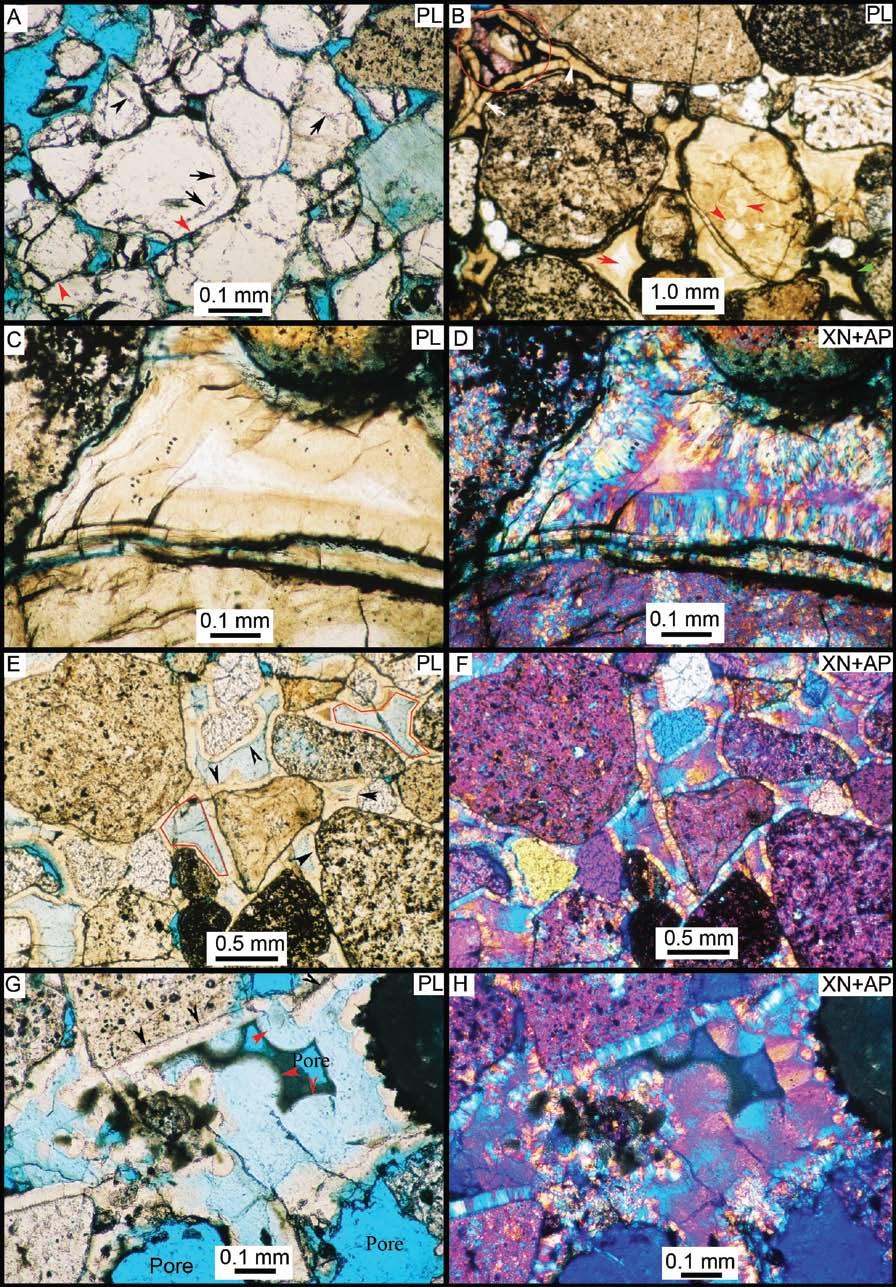
6 Supplemental Figure 5. Photomicrographs from samples of cemented channel materials in the Brushy Basin Member of the Morrison Formation (Figure 8, stop 2). Examples A-D are from site L and examples E-F are from site M. A) Low-resolution view of quartz sandstone with extensive calcite cement. 50X B) Interpenetrating quartz grain contacts (black arrows) provide evidence of burial. 250X C) Sparry calcite cement is pink due to Alizarin Red-S staining. 200X D) Same view with XN+AP. 200X E) Adjacent pores have different composition: calcite (black arrows) and ferroan calcite (red arrows). Dissolution pores (blue voids) are also present. 200X F) Same view with XN. Note pressure-solution grain contacts. 200X 6
 In channel D, muddy deposits are protected by overlying channel deposits, forming an overhang in the picture.")
7 Supplemental Figure 6. Several examples of outcrop exposures at the base of paleochannels in the Ruby Ranch Member. A) In channel D, muddy deposits are protected by overlying channel deposits, forming an overhang in the picture. Green and yellow-brown mudstone subjacent to the channel base formed in a reducing environment at the channel-floodplain interface. Photo by R. Williams. B) In places, there are large (~50 cm diameter) limestone ripup clasts, likely lacustrine deposits that were reworked during high flow events. This example is from channel A. Photo by J. Zimbelman. C) Elsewhere the base of channel D is marked by a basal conglomerate with pedogenic carbonate nodules up to 10 cm in diameter; a similar basal conglomerate is observed elsewhere in the Cedar Mountain Formation to the north (Currie, 1998). Photo by R. Williams. 7
8 Supplemental Figure 7. 8
 Quartz-cemented coarse sandstone with secondary porosity (blue voids).")
9 Supplemental Figure 7. Photomicrographs from samples of cemented channel materials in the Cedar Mountain Formation. Sample locations are marked on Figure 10B with example A from site E, examples B-D from site F and examples E-H from site G. A) Quartz-cemented coarse sandstone with secondary porosity (blue voids). Dust lines (arrows) demarcate quartz grain and silica overgrowth cement boundary. Linear grain contacts (red arrows) are evidence for pressure solution modification and indicate the specimen was largely uncemented prior to burial. Plain light (PL) 160X. B) Sandstone with multiple stages of silica cement formed under near-surface conditions: isopachous silica cements encircling grains (white arrows) form in phreatic pores, pore-filling silica cement is dense and brownish (green arrow), and third-generation crystalline cement with white core (red arrows). Alizarin Red-S staining highlights minor, late-stage calcite cement (red circle). PL 18.5X. C) Pore-filling siliceous cement. PL 160X. D) Same view as previous with crossed Nichols (XN) and gypsum accessory plate (AP) which highlights the fibrous character of the chalcedony cement. 160X. E) Isopachous silica cement (black arrows) encircles grains. Light blue color (from blue impregnated epoxy; red outline) indicates the microporous nature of the pore-filling silica cement. 40X. F) Same view as previous with XN+AP. Fibrous character of chalcedony cement is evident. 40X. G) Isopachous silicious cement (black arrows) and secondary botryoidal, microporous silicious cements (red arrows) in pore centers. 130X. H) Same view as previous with XN+AP shows the radiating fiber of the botryoidal cement. 130X. Supplemental Figure 8. Oblique aerial photograph to the southeast of a sinuous section of channel A in the Cedar Mountain Formation. Water gap marked by black arrow at top right. Older channels (white arrow at center bottom) beneath the main trunk channel are preserved only on the north side. Image width in foreground is ~1.8 km. Illumination is from the upper left. Photo by R. Williams. 9

10 Supplemental Figure 9A. 10
, presumably the downstream section, is buried beneath rock layers (black arrow).")
11 Supplemental Figure 9. A) Branching landform in Meridiani Planum that exhibits variations in preservation style from positive to negative relief. Black boxes in A are Enlargement of subscenes from panel A are presented in panels B-E. Northern portion of system (B), presumably the downstream section, is buried beneath rock layers (black arrow). The landform transitions from positive relief (low-relief ridge marked by black arrow) to negative relief trough (white arrows in C) that has a medial ridge in places. The southern portion of the landform is marked by a series of aligned pits that trace out the branching pattern (E). At higher resolution (D), the stratigraphic relationship is evident with the low-relief, light-toned ridge (the inverted channel) capped by a narrow band of the former overburden. The cracked pattern on the light-toned ridge and superposing material (cracks are sometimes traverse across the two materials, marked by black arrows) differ in size and configuration from the polygonal pattern on the surrounding plains. Panels A-C and E are subframes of CTX image P03_002390_1840 near 4.6 N, 1.3 W. Panel D is subframe of HiRISE PSP_004091_1845. Illumination is from left for all images. 11

12 Supplemental Figure 10. Oblique aerial photograph of two channel segments in the Cedar Mountain Formation looking northward, at the location near the labels F and G in Figure 10. The apparent bifurcation marked by black arrows is actually two segments at two different topographic and stratigraphic levels. The inverted paleochannel segment from top to bottom (north to south, segment D) in image is stratigraphically higher than the paleochannel segment that extends to the right (westernmost section of segment B). Scale bar is for image foreground. The Late Cretaceous Book Cliffs (e.g. Young, 1955), which form the northern rim of the Colorado Plateau in eastern Utah, are visible in the background. Photo by R. Williams. 12
.")
13 Supplemental Figure 11. A) Sinuous ridges in the Aeolis/Zephyria Plana region immediately east of the location in Figure 6. Black boxes are approximate regions enlarged in panels B and C, which show areas where eolian erosion has modified former sinuous ridges into aligned knobs and mesas (black arrows). Subframe of CTX image P03_002081_1751 is located near 5 S, 205 W. Illumination is from lower left. 13

14 Supplemental Figure 12. A) Examples of degradation along sections of inverted paleochannels in the Ruby Ranch Member of the Cedar Mountain Formation. Erosion exploits the joints and faults in the paleochannels, producing blocks of cemented channel sediments. Blocks that have been transported downslope by mass wasting are marked by white circles. Differential erosion is also evident, with the underlying mudstone preferentially removed from beneath the more resistant paleochannels caprock; this undermining produces alcoves (red arrow). B) Cemented fluvial sediments form a capstone (white arrow). Where the capstone has been removed, the underlying mudstone still marks the original flow path (in this case curing around to the lower right in the image). 14
 Quartz sandstone with silica overgrowth cements and minor calcite (red due to Alizarin Red-S stain) cement in plain light with neutral density filter. 50X.")
15 Supplemental Figure 13. Photomicrographs from samples of cemented channel materials in the Salt Wash Member of the Morrison Formation (stop 7; Figure 12). A) Quartz sandstone with silica overgrowth cements and minor calcite (red due to Alizarin Red-S stain) cement in plain light with neutral density filter. 50X. B) Same view as in previous figure with XN. 50X C) Sparry calcite (red) and silica cement around detrital quartz grains. 160X. D) Same view as in previous figure. 160X. E) Close-up view of dust lines (arrows) separating grains from silica cement. 200X. F) Same view as in previous figure. Optical continuity between grain and cement is evident under XN. 200X. 15

16 Supplemental Figure 14. View of the contact between cemented fluvial deposits and underlying red floodplain materials within the Salt Wash Member of the Morrison Formation. The capstone margin is near vertical and cut by fractures. Approximate outcrop thickness is 2.5 m. Photo by R. Williams. 16
Field guide to exhumed paleochannels near Green River, Utah: Terrestrial analogs for sinuous ridges on Mars
 Field guide to exhumed paleochannels near Green River, Utah: Terrestrial analogs for sinuous ridges on Mars Rebecca M. E. Williams 1, Rossman P. Irwin III 1, James R. Zimbelman 2, Thomas C. Chidsey, Jr.
Sediment and sedimentary rocks Sediment
 Sediment and sedimentary rocks Sediment From sediments to sedimentary rocks (transportation, deposition, preservation and lithification) Types of sedimentary rocks (clastic, chemical and organic) Sedimentary
New HiRISE Views of Eberswalde Crater and a Tour of Fluvial Systems. Melissa Rice, Jim Bell MSL LSWG telecon, 8 September 2010
 New HiRISE Views of Eberswalde Crater and a Tour of Fluvial Systems Melissa Rice, Jim Bell MSL LSWG telecon, 8 September 2010 HiRISE Coverage posted on the LSWG site on 12 April NEW HiRISE Coverage 5 new
Cenozoic Extensional Basin Development and Sedimentation in SW Montana
 Cenozoic Extensional Basin Development and Sedimentation in SW Montana Robert C. Thomas Department of Environmental Sciences, The University of Montana Western, Dillon, MT 59725, (406) 683-7615, r_thomas@umwestern.edu
Dakota Sandstone. of the Moxa Arch and Surrounding Green River Basin
 Dakota Sandstone of the Moxa Arch and Surrounding Green River Basin Dakota Sandstones of the Green River Basin Overview The Dakota sandstones of the Moxa Arch and surrounding Green River Basin remain attractive
Bryce Canyon. Bryce Zion
 Bryce Canyon Located ~50 mi NE of Zion in southern Utah On Paunsaugunt Plateau: Wetter and Colder than Zion Bounded by Sevier Fault to west and Paunsaugunt Fault to east Rocks are ~100 Ma older than at
Chapter 6 Pages of Earth s Past: Sedimentary Rocks
 Chapter 6 Pages of Earth s Past: Sedimentary Rocks Introduction! Drilling into the bottom of the North Sea, we encounter: " Soft mud and loose sand, silt, pebbles, and shells. Then: " Similar materials
=%REPORT RECONNAISSANCE OF CHISHOLM LAKE PROSPECT. October 25, 1977
 =%REPORT ON FIELD RECONNAISSANCE OF CHISHOLM LAKE PROSPECT October 25, 1977 Bruce D. Vincent Imperial Oil Limited, Minerals - Coal, CALGARY, ALBERTA CHISHOLM LAKE PROSPECT Introduction The Chisholm Lake
Photogeologic Mapping of Mars
 Exercise Two and Fifteen are suggested as introductory exercises. 2.0 hours Exercise Seventeen Photogeologic Mapping of Mars Instructor Notes Suggested Correlation of Topics Deductive reasoning, geologic
Lab 7: Sedimentary Structures
 Name: Lab 7: Sedimentary Structures Sedimentary rocks account for a negligibly small fraction of Earth s mass, yet they are commonly encountered because the processes that form them are ubiquitous in the
Lecture Outline Wednesday - Friday February 14-16, 2018
 Lecture Outline Wednesday - Friday February 14-16, 2018 Quiz 2 scheduled for Friday Feb 23 (Interlude B, Chapters 6,7) Questions? Chapter 6 Pages of the Past: Sedimentary Rocks Key Points for today Be
Summary. Introduction. Observations and Interpretations
 Lower McMurray Formation sinkholes and their fill fabrics: effects of salt dissolution collapse-subsidence across the northern Athabasca oil sands deposit Paul L. Broughton, Chevron Canada Resources, Calgary,
Name: Which rock layers appear to be most resistant to weathering? A) A, C, and E B) B and D
 A, C, and E B) B and D") Name: 1) The formation of soil is primarily the result of A) stream deposition and runoff B) precipitation and wind erosion C) stream erosion and mass movement D) weathering and biological activity 2)
Name: 1) The formation of soil is primarily the result of A) stream deposition and runoff B) precipitation and wind erosion C) stream erosion and mass movement D) weathering and biological activity 2)
Continental Landscapes
 Continental Landscapes Landscape influenced by tectonics, climate & differential weathering Most landforms developed within the last 2 million years System moves toward an equilibrium Continental Landscapes
THE NEW GEOLOGY OF MARS: TOP TEN RESULTS OF POST-VIKING GLOBAL MAPPING AND CRATER-DATING
 THE NEW GEOLOGY OF MARS: TOP TEN RESULTS OF POST-VIKING GLOBAL MAPPING AND CRATER-DATING K.L. Tanaka 1, J.A. Skinner, Jr. 1, C.M. Fortezzo 1, T.M. Hare 1, R.P. Irwin 2, T. Platz 3, G. Michael 3, J.M. Dohm
Science Targets Along a Proposed Gale Traverse. Ryan Anderson, Dawn Sumner & Jim Bell 5 th Mars Science Laboratory Landing Site Workshop May 17, 2011
 Science Targets Along a Proposed Gale Traverse Ryan Anderson, Dawn Sumner & Jim Bell 5 th Mars Science Laboratory Landing Site Workshop May 17, 2011 Traverse Overview This is a notional traverse. Based
2. What type of rocks would you expect in this area, based on the topography? What is your reasoning?
 Geology 101 Bonus Lab Name Topographic maps are useful in helping us interpret the history of the landscape of an area. The questions below are designed to help you learn to interpret topographic maps.
High-resolution Sequence Stratigraphy of the Glauconitic Sandstone, Upper Mannville C Pool, Cessford Field: a Record of Evolving Accommodation
 Page No. 069-1 High-resolution Sequence Stratigraphy of the Glauconitic Sandstone, Upper Mannville C Pool, Cessford Field: a Record of Evolving Accommodation Thérèse Lynch* and John Hopkins, Department
Quiz 1. 3) Which of the following planetary bodies has the least number of impact craters on its surface? A) Mercury B) Mars C) the Moon D) Earth
 Which of the following planetary bodies has the least number of impact craters on its surface? A) Mercury B) Mars C) the Moon D) Earth") Quiz 1 1) Earth's atmosphere is unique among the moons and planets in that A) it has a nitrogen (N2) rich atmosphere. B) it is rich in oxygen (O2) and nitrogen (N2). C) it is rich in carbon dioxide because
Quiz 1 1) Earth's atmosphere is unique among the moons and planets in that A) it has a nitrogen (N2) rich atmosphere. B) it is rich in oxygen (O2) and nitrogen (N2). C) it is rich in carbon dioxide because
Sequence Stratigraphy of the Upper Cretaceous Niobrara Formation, A Bench, Wattenberg Field, Denver Julesburg Basin, Colorado*
 Sequence Stratigraphy of the Upper Cretaceous Niobrara Formation, A Bench, Wattenberg Field, Denver Julesburg Basin, Colorado* Lisa E. Remington LaChance 1 and Mark C. Robinson 1 Search and Discovery Article
Structural Deformation and Karst in the Devonian Waterways Formation: Examples from Outcrops along the Athabasca River*
 Structural Deformation and Karst in the Devonian Waterways Formation: Examples from Outcrops along the Athabasca River* Chris L. Schneider 1 and Matthias Grobe 2 Search and Discovery Article #51073 (2015)
Cretes and Chemical Landscapes, South Australia
 5 th ARGA Conference Wallaroo, S.A. 8-12 April, 2018 Cretes and Chemical Landscapes, South Australia K.G. McQueen IAE, University of Canberra Physical and Chemical Landscapes Processes Landscapes erosion
Structural Geology Lab. The Objectives are to gain experience
 Geology 2 Structural Geology Lab The Objectives are to gain experience 1. Drawing cross sections from information given on geologic maps. 2. Recognizing folds and naming their parts on stereoscopic air
Examining the Terrestrial Planets (Chapter 20)
") GEOLOGY 306 Laboratory Instructor: TERRY J. BOROUGHS NAME: Examining the Terrestrial Planets (Chapter 20) For this assignment you will require: a calculator, colored pencils, a metric ruler, and your geology
GEOLOGY 306 Laboratory Instructor: TERRY J. BOROUGHS NAME: Examining the Terrestrial Planets (Chapter 20) For this assignment you will require: a calculator, colored pencils, a metric ruler, and your geology
The petrography of sandstone samples from the Upper Greensand Formation in southern England.
 BRITISH GEOLOGICAL SURVEY TECHNICAL REPORT Stratigraphy Series IR/05/138 The petrography of sandstone samples from the Upper Greensand Formation in southern England. G.K.Lott (British Geological Survey)
Practice Test Rocks and Minerals. Name. Page 1
 Name Practice Test Rocks and Minerals 1. Which rock would be the best source of the mineral garnet? A) basalt B) limestone C) schist D) slate 2. Which mineral is mined for its iron content? A) hematite
Module 9 Sedimentary Rocks
 Module 9 Sedimentary Rocks SEDIMENTARY ROCKS Rocks formed from material derived from preexisting rocks by surfacial processes followed by diagenesis There are two main classes of sedimentary rocks Clastic
GLY 155 Introduction to Physical Geology, W. Altermann. Press & Siever, compressive forces. Compressive forces cause folding and faulting.
 Press & Siever, 1995 compressive forces Compressive forces cause folding and faulting. faults 1 Uplift is followed by erosion, which creates new horizontal surface. lava flows Volcanic eruptions cover
COSMORPHOLOGY - May 2009
 Name COSMORPHOLOGY - May 2009 Geologic landforms Purpose: By studying aerial photographs you will learn to identify different kinds of geologic features based on their different morphologies and learn
Structural Geology of the Mountains
 Structural Geology of the Mountains Clinton R. Tippett Shell Canada Limited, Calgary, Alberta clinton.tippett@shell.ca INTRODUCTION The Southern Rocky Mountains of Canada (Figure 1) are made up of several
Unit 7.2 W.E.D. & Topography Test
 Name: Score: Unit 7.2 W.E.D. & Topography Test 1. 2. 3. 4. 5. 6. 7. 8. 9. 10. 11. 12. 13. 14. 15. 16. 17. 18. 19. 20. 21. 22. 23. 24. 25. 1. The formation of mountains is due mainly to while the destruction
Geo 302D: Age of Dinosaurs. LAB 1: Introduction to Rocks and Sedimentary Processes
 Geo 302D: Age of Dinosaurs LAB 1: Introduction to Rocks and Sedimentary Processes We would not be able to address the interesting questions of dinosaurs and their place in the history of life without the
Wind Mountain Project Summary Memo Feeder Program
 A Manex Resource Group Company Wind Mountain Project Summary Memo Feeder Program J.A. Kizis, Jr., February 07, 2018 Assays have been received for both holes drilled at Wind Mountain during late 2017 and
Geology 252, Historical Geology, California State University, Los Angeles - professor: Dr. Alessandro Grippo
 LAB # 1 - CLASTIC ROCKS Background: - Mechanical and Chemical Weathering - Production of Clastic Sediment - Classification of Sediment according to size: Gravel, Sand, Silt, Clay - Erosion, Transportation
UNIT 4 SEDIMENTARY ROCKS
 UNIT 4 SEDIMENTARY ROCKS WHAT ARE SEDIMENTS Sediments are loose Earth materials (unconsolidated materials) such as sand which are transported by the action of water, wind, glacial ice and gravity. These
A Classification Oncoidal wackestone. Interpretation Shallow tail or channel environment.
 A132 Photo 1: Matrix of micrite/ carbonaceous mud with high percentage of siliciclastic sand and silt. Shrinkage fractures partially filled with microcrystalline carbonate cement. Other small voids contain
Starting at Rock Bottom
 Starting at Rock Bottom At rock bottom of the Brushy Creek site s geological column lies the first clue to human habitation: A smelting and heattreating furnace, and mold, carved into Bed Ked: Figure 15
Outcrops from Every Continent and 20 Countries in 140 Contributions. Tor H. Nilsen, Roger D. Shew, Gary S. Steffens, and Joseph R.J. Studlick.
 Paper VIII Tor H. Nilsen, Roger D. Shew, Gary S. Steffens, and Joseph R.J. Studlick Editors Outcrops from Every Continent and 20 Countries in 140 Contributions http://bookstore.aapg.org Length ~ 23 m (75.5
Geo 302D: Age of Dinosaurs. LAB 2: Sedimentary rocks and processes
 Geo 302D: Age of Dinosaurs LAB 2: Sedimentary rocks and processes Last week we covered the basic types of rocks and the rock cycle. This lab concentrates on sedimentary rocks. Sedimentary rocks have special
Meandering Miocene Deep Sea Channel Systems Offshore Congo, West Africa
 Meandering Miocene Deep Sea Channel Systems Offshore Congo, West Africa S. Baer* (PGS), J. E. Comstock (PGS), K. Vrålstad (PGS), R. Borsato (PGS), M. Martin (PGS), J.P. Saba (SNPC), B. Débi-Obambé (SNPC)
Questions for the Edwards formation
 Name: Professor name: Class Time: The Virtual Field trip is to be completed by your self. You should not work with a partner. This is not group work. Nor should you search for answers on the internet.
Sedimentary Rocks. Weathering. Mechanical & Chemical Weathering. Sediments. Lithification. Deposition. Transport. Erosion.
 Lithification Sedimentary Rocks Sediments Deposition Transport Erosion Weathering Weathering The sediments that make up sedimentary rocks are produced by: Mechanical & Chemical Weathering Mechanical Weathering
EPS 50 Lab 4: Sedimentary Rocks
 Name: EPS 50 Lab 4: Sedimentary Rocks Grotzinger and Jordan, Chapter 5 Introduction In this lab we will classify sedimentary rocks and investigate the relationship between environmental conditions and
Clastic Sedimentary Rocks
 Clastic Sedimentary Rocks Alessandro Grippo, Ph.D. Alternating sandstones and mudstones in Miocene turbidites Camaggiore di Firenzuola, Firenze, Italy Alessandro Grippo review Mechanical weathering creates
Earth History: Record in the Rocks
 Earth History: Record in the Rocks The geologic history of Earth can be read from rocks if you know what to look for. In this presentation, you will see examples of many types of clues, stored in rocks.
SECTION 4 TABLES. 1 Summary of Hydrogeologic Parameters for Various Stratigraphic Units FIGURES
 SECTION 4 4.0 OVERVIEW OF GEOLOGY AND HYDROGEOLOGY... 13 4.1 Comparison of East and West Sides of Study Area... 15 4.2 Bedrock Sequence... 17 4.3 Mancos Shale (Upper Cretaceous)... 18 4.4 Mesaverde Formation
Sediment. Weathering: mechanical and chemical decomposition and disintegration of rock and minerals at the surface
 Sediment Some basic terminology Weathering: mechanical and chemical decomposition and disintegration of rock and minerals at the surface Erosion: removal of weathered rock and minerals from one place to
1. Base your answer to the following question on the map below, which shows the generalized bedrock of a part of western New York State.
 1. Base your answer to the following question on the map below, which shows the generalized bedrock of a part of western New York State. 3. The table below describes the deposits that an observer saw while
Red Sea Basins. by Prof. Dr. Abbas Mansour
 Red Sea Basins TECTONO-SEDIMENTARY EVOLUTION OF THE NW PARTS OF THE RED SEA The pre-rift rift by Prof. Dr. Abbas Mansour 1.a. The Precambrian basement and the inherited structural pattern of the rift
Section I: Multiple Choice Select the best answer to each question. Mark your final answer on the answer sheet. (1 pt each)
") Sedimentary Rocks & Surface Processes Quest Name: Earth Science 2013 Block: Date: Section I: Multiple Choice Select the best answer to each question. Mark your final answer on the answer sheet. (1 pt each)
Sedimentary Rocks & Surface Processes Quest Name: Earth Science 2013 Block: Date: Section I: Multiple Choice Select the best answer to each question. Mark your final answer on the answer sheet. (1 pt each)
Page 1. Name:
 Name: 1) Which property would best distinguish sediment deposited by a river from sediment deposited by a glacier? thickness of sediment layers age of fossils found in the sediment mineral composition
Devil s Punchbowl -Virtual Field Trip-
 Devil s Punchbowl -Virtual Field Trip- School of GEOGRAPHY & GEOLOGY Carolyn Eyles & Susan Vajoczki Prepared by Zachary Windus and Liz Kenny From McMaster University take Main Street West towards Ancaster.
Continuity and Compartmentalization of Viking Formation gas production from the Ricinus / Bearberry area of the Rocky Mountain Triangle Zone
 Page No. 001-1 Continuity and Compartmentalization of Formation gas production from the Ricinus / Bearberry area of the Rocky Mountain Triangle Zone David Halwas* (Senior Staff Geologist), Darryl Parry
Page 1. Name:
 Name: Questions 1 through 3 refer to the following: The diagrams below represent two rock outcrops found several miles apart in New York State. Individual rock layers are lettered, and fossils and rock
4.2 Valles Marineris 99
 4.2 Valles Marineris 99 Ganges 2: The ILD (7.4 S/313.1 E) is located in the eastern Valles Marineris (Fig. 2, 10), in Ganges Chasma (Fig. 28), east of Ganges 1 (Fig. 52). Ganges 2 shows a N-S strike, measures
Structural Geology Lab. The Objectives are to gain experience
 Geology 2 Structural Geology Lab The Objectives are to gain experience 1. Drawing cross sections from information given on geologic maps. 2. Recognizing folds and naming their parts on stereoscopic air
GLG Chapter 7 Sedimentary Environments & Rocks
 GLG 101 - Chapter 7 Sedimentary Environments & Rocks Name Note, Oct 11: I ll be writing this study sheet over the next few days. Each day I will add questions until the entire chapter is done, hopefully
Surface Process Hazards Unit 2: Landscape Feature Scavenger Hunt
 Surface Process Hazards Unit 2: Landscape Feature Scavenger Hunt Sarah Hall (College of the Atlantic) and Becca Walker (Mt. San Antonio College) The following pages each have a series of questions about
PRECAMBRIAN CRYSTALLINE AQUIFER (METAMORPHIC ROCKS)
") HAYWARD QUADRANGLE: Groundwater Production by Aquifer In the 56-square-mile area of the Hayward Quadrangle, groundwater is produced from metamorphic crystalline rocks of the Precambrian basement (in the
HAYWARD QUADRANGLE: Groundwater Production by Aquifer In the 56-square-mile area of the Hayward Quadrangle, groundwater is produced from metamorphic crystalline rocks of the Precambrian basement (in the
Steve Cumella 1. Search and Discovery Article # (2009) Posted July 30, Abstract
 Posted July 30, Abstract") AV Geology of the Piceance Basin Mesaverde Gas Accumulation* Steve Cumella 1 Search and Discovery Article #110106 (2009) Posted July 30, 2009 *Adapted from oral presentation at AAPG Annual Convention,
AV Geology of the Piceance Basin Mesaverde Gas Accumulation* Steve Cumella 1 Search and Discovery Article #110106 (2009) Posted July 30, 2009 *Adapted from oral presentation at AAPG Annual Convention,
Pratice Surface Processes Test
 1. The cross section below shows the movement of wind-driven sand particles that strike a partly exposed basalt cobble located at the surface of a windy desert. Which cross section best represents the
Sedimentary Rocks. Origin, Properties and Identification. Geology Laboratory GEOL 101 Lab Ray Rector - Instructor
 Sedimentary Rocks Origin, Properties and Identification Geology Laboratory GEOL 101 Lab Ray Rector - Instructor Sedimentary Rock Origin and Identification Lab Pre-Lab Internet Link Resources 1) http://www.rockhounds.com/rockshop/rockkey/index.html
Cretaceous Shelf Sandstones and Shelf Depositional Sequences, Western Interior Basin, Utah, Colorado and New Mexico
 Cretaceous Shelf Sandstones and Shelf Depositional Sequences, Western Interior Basin, Utah, Colorado and New Mexico Salt Lake City, Utah to Albuquerque, New Mexico June 30-July 7, 1989 Field Trip Guidebook
Update on Trenton Black River Playbook Study-New York State Museum
 Update on Trenton Black River Playbook Study-New York State Museum Taury Smith, Rich Nyahay, Rick Bray, Courtney Lugert, Rose Schulze and Brian Slater New York State Museum Task 4: Geochemistry Task 1
The Nature of Sedimentary Rocks
 The Nature of Sedimentary Rocks Sedimentary rocks are composed of: Fragments of other rocks Chemical precipitates Organic matter or biochemically produced materials The Nature of Sedimentary Rocks Sedimentary
Beneath the sand of the Tanami Desert
 Beneath the sand of the Tanami Desert ARGA 2018, Wallaroo, SA Nadir de Souza Kovacs Ngururrpa program The program area covers the traditional land of the Parna Ngururrpa People in a remote part of the
American Institute of Professional Geologists South Dakota Section
 American Institute of Professional Geologists South Dakota Section 2015 Field Trip Guide Deadwood Formation in the Black Hills of South Dakota and Frac Sand Potential Saturday, September 12, 2015 1 Field
Seismic Reflection Imaging across the Johnson Ranch, Valley County, Idaho
 Seismic Reflection Imaging across the Johnson Ranch, Valley County, Idaho Report Prepared for the Skyline Corporation Lee M. Liberty Center for Geophysical Investigation of the Shallow Subsurface (CGISS)
The Kingfisher Field, Uganda - A Bird in the Hand! S R Curd, R Downie, P C Logan, P Holley Heritage Oil plc *
 A Bird in the Hand! EXTENDED ABSTRACT The Kingfisher Field, Uganda - A Bird in the Hand! Heritage Oil plc * The Kingfisher Field lies on Uganda s western border beneath Lake Albert, situated in the western
!'f \, w. Alan Stewart Colorado Exploration Company, Golden STRUCTURE OF THE FOOTHILLS AREA WEST OF DENVER, COLORADO. Introduction
 STRUCTURE OF THE FOOTHLLS AREA WEST OF DENVER, COLORADO w. Alan Stewart Colorado Exploration Company, Golden ntroduction i ; The dominant structural features west of Denver and along the mountain front
EROSION, DEPOSITION AND SEDIMENTARY ROCKS. Reading: Earth Science Tarbuck and Lutgens Chapter 5: pages Chapter 3: pages 52-54, 61-69
 EROSION, DEPOSITION AND SEDIMENTARY ROCKS Reading: Earth Science Tarbuck and Lutgens Chapter 5: pages 124-133 Chapter 3: pages 52-54, 61-69 Base Level Resistant bed Resistant bed creates a local base level
Cretaceous, Dakota Formation, Terra Cotta Member South Side of I-70, Salina County, Kansas
 Cretaceous, Dakota Formation, Terra Cotta Member South Side of I-70, Salina County, Kansas Written By: Steven D.J. Baumann G-102010-1A Outcrop looking southeast Photo taken by: Steven Baumann on 10-20-2010
Chapter 5. The Sedimentary Archives
 Chapter 5 The Sedimentary Archives Factors affecting Sedimentary Characteristics 1. Tectonic setting 2. Physical, chemical, and biological processes in the depositional environment 3. Method of sediment
402: Sedimentary Petrology
 UNIVERSITY OF SOUTH ALABAMA 402: Sedimentary Petrology Lecture 14: Siliciclastic Diagenesis Instructor: Dr. Douglas W. Haywick Last Time (online) Immature siliciclastic sediment and sedimentary rocks Pictorial
Structural Features and Fracture Orientation similarities between outcrops of the Ridgeley Sandstone
 The JUNIATA JOURNAL of GEOLOGY, 1, 1-8 (2014) Original article Structural Features and Fracture Orientation similarities between outcrops of the Ridgeley Sandstone Robert W. Baronner Two outcrops of the
B) color B) Sediment must be compacted and cemented before it can change to sedimentary rock. D) igneous, metamorphic, and sedimentary rocks
 color B) Sediment must be compacted and cemented before it can change to sedimentary rock. D) igneous, metamorphic, and sedimentary rocks") 1. Which characteristic of nonsedimentary rocks would provide the least evidence about the environment in which the rocks were formed? A) structure B) color C) crystal size D) mineral composition 2. Which
1. Which characteristic of nonsedimentary rocks would provide the least evidence about the environment in which the rocks were formed? A) structure B) color C) crystal size D) mineral composition 2. Which
Soils, Hydrogeology, and Aquifer Properties. Philip B. Bedient 2006 Rice University
 Soils, Hydrogeology, and Aquifer Properties Philip B. Bedient 2006 Rice University Charbeneau, 2000. Basin Hydrologic Cycle Global Water Supply Distribution 3% of earth s water is fresh - 97% oceans 1%
MULTIPLE CHOICE. Choose the one alternative that best completes the statement or answers the question.
 GLS100-01 Quiz#7 chapters 5 and 6 Fall 2009 Name MULTIPLE CHOICE. Choose the one alternative that best completes the statement or answers the question. 1) Clay minerals formed from gabbro or diorite bedrock
Unconformities are depositional contacts that overlie rocks distinctly older than they are. They are often called gaps in the sedimentary record.
 UNCONFORMITIES Unconformities are depositional contacts that overlie rocks distinctly older than they are. They are often called gaps in the sedimentary record. The contact represents time when no sediment
ESC102. Sedimentary Rocks. Our keys to the past. Monday, February 11, 13
 ESC102 Sedimentary Rocks Our keys to the past Sedimentary Rocks Sedimentary rocks are rocks that form through the accumulation of sediment and the process of lithification. Lithification occurs after deposition
Chapter 3 Sedimentation of clay minerals
 Chapter 3 Sedimentation of clay minerals 3.1 Clay sedimentation on land 3.2 From land to sea 3.3 Clay sedimentation in the sea 1 3.1 Clay sedimentation on land Deserts Glaciers Rivers Lacustrine 2 University
Black Point & Bihler Point
 Black Point & Bihler Point Conglomerate Photo: looking north toward end of Black Point (south of post 1) All of the rocks in this photo are conglomerate. Both Black Point and Bihler Point are formed from
CEE 437 Lecture 10 Rock Classification. Thomas Doe
 CEE 437 Lecture 10 Rock Classification Thomas Doe Igneous Origins Intrusive Batholithic or plutonic: phaneritic Dikes or sills that chill rapidly: aphanitic Extrusive deposition as melt (lava) pyroclastic
Maine Geologic Facts and Localities October, Lobster Lake, Maine. Text by Robert G. Marvinney. Maine Geological Survey
 Maine Geologic Facts and Localities October, 1998 Lobster Lake, Maine 45 o 51 7.91 N, 69 o 30 53.88 W Text by Robert G. Marvinney, Department of Agriculture, Conservation & Forestry 1 Map by Introduction
transform boundary Photograph by Robert E. Wallace, USGS.
 transform boundary The San Andreas Fault is undoubtedly the most famous transform boundary in the world. To the west of the fault is the Pacific plate, which is moving northwest. To the east is the North
New York University Excavations at Amheida 2010 Geological Investigations LOCAL GEOLOGY
 New York University Excavations at Amheida 2010 Geological Investigations LOCAL GEOLOGY The geology of the Amheida area has been outlined previously by the site topographers; the general geomorphology
A comparison of structural styles and prospectivity along the Atlantic margin from Senegal to Benin. Peter Conn*, Ian Deighton* & Dario Chisari*
 A comparison of structural styles and prospectivity along the Atlantic margin from Senegal to Benin Overview Peter Conn*, Ian Deighton* & Dario Chisari* * TGS, Millbank House, Surbiton, UK, KT6 6AP The
As compaction and cementation of these sediments eventually occur, which area will become siltstone? A) A B) B C) C D) D
 A B) B C) C D) D") 1. A student obtains a cup of quartz sand from a beach. A saltwater solution is poured into the sand and allowed to evaporate. The mineral residue from the saltwater solution cements the sand grains together,
1. A student obtains a cup of quartz sand from a beach. A saltwater solution is poured into the sand and allowed to evaporate. The mineral residue from the saltwater solution cements the sand grains together,
The boundary between two formations (or any distinct layers) is called a contact. Sedimentary rocks cover 75% of continents.
 is called a contact. Sedimentary rocks cover 75% of continents.") Sedimentary Rocks Sedimentary rocks form at the Earth s surface through interactions of the hydrologic system and the crust. Fortunately, many of these processes are in operation today, and geologists
Sedimentary Rocks Sedimentary rocks form at the Earth s surface through interactions of the hydrologic system and the crust. Fortunately, many of these processes are in operation today, and geologists
6. Crater Rim Uplift and Crater Wall Collapse
 6. Crater Rim Uplift and Crater Wall Collapse The basic processes involved in crater rim uplift are understood, but there is a lot of evidence at the crater that has not been fully explored and may eventually
1. How many unconformities exist in each column? Note that it is not the same number, necessarily, for each column!
 Geology 103 Name(s): Lab 5: Sequence stratigraphy Introduction: In the previous lab, you were able to illustrate Walther s Law by showing how transgressive rock sequences mirrored the offshore facies sequence.
Summary. Introduction
 Orthogonal geometrics of lower McMurray Formation sand complexes: effects of salt dissolution collapse-subsidence across the northern Athabasca oil sands deposit Paul L. Broughton, Chevron Canada Resources,
North Greenland collection of oblique aerial photographs - (Twin Otter photos)
") North Greenland collection of oblique aerial photographs - (Twin Otter photos) The Geological Survey of Greenland (now part of the Geological Survey of Denmark and Greenland: GEUS) carried out a systematic
North Greenland collection of oblique aerial photographs - (Twin Otter photos) The Geological Survey of Greenland (now part of the Geological Survey of Denmark and Greenland: GEUS) carried out a systematic
Sedimentary Rocks. Origin, Properties and Identification. Physical Geology GEOL 100. Ray Rector - Instructor
 Sedimentary Rocks Origin, Properties and Identification Physical Geology GEOL 100 Ray Rector - Instructor Sedimentary Rock Origin and Identification Lab Pre-Lab Internet Link Resources 1) http://www.rockhounds.com/rockshop/rockkey/index.html
A Regional Diagenetic and Petrophysical Model for the Montney Formation, Western Canada Sedimentary Basin*
 A Regional Diagenetic and Petrophysical Model for the Montney Formation, Western Canada Sedimentary Basin* Noga Vaisblat 1, Nicholas B. Harris 1, Vincent Crombez 2, Tristan Euzen 3, Marta Gasparrini 2,
Lower Skinner Valley Fill Sandstones: Attractive Exploration Targets on the Northeast Oklahoma Platform*
 Lower Skinner Valley Fill Sandstones: Attractive Exploration Targets on the Northeast Oklahoma Platform* By Jim Puckette 1 Search and Discovery Article #10050 (2003) *Adapted from presentation to Tulsa
Data Repository item DATA REPOSITORY
 Data Repository item 2003053 1 DATA REPOSITORY Stable isotope and trace-element geochemistry of the basal Bouse Formation carbonate, southwestern USA: Implications for the Pliocene uplift history of the
mountain rivers fixed channel boundaries (bedrock banks and bed) high transport capacity low storage input output
 high transport capacity low storage input output") mountain rivers fixed channel boundaries (bedrock banks and bed) high transport capacity low storage input output strong interaction between streams & hillslopes Sediment Budgets for Mountain Rivers Little
mountain rivers fixed channel boundaries (bedrock banks and bed) high transport capacity low storage input output strong interaction between streams & hillslopes Sediment Budgets for Mountain Rivers Little
Classify Rock (rock1)
") Name: Date: 1. Cleavage of a mineral is related to a mineral's A. chemical composition. B. streak color. C. luster. D. crystalline structure. 2. Which is not part of the definition of a mineral? A. naturally
Name: Date: 1. Cleavage of a mineral is related to a mineral's A. chemical composition. B. streak color. C. luster. D. crystalline structure. 2. Which is not part of the definition of a mineral? A. naturally