New York University Excavations at Amheida 2010 Geological Investigations LOCAL GEOLOGY
|
|
|
- Logan Ray
- 5 years ago
- Views:
Transcription
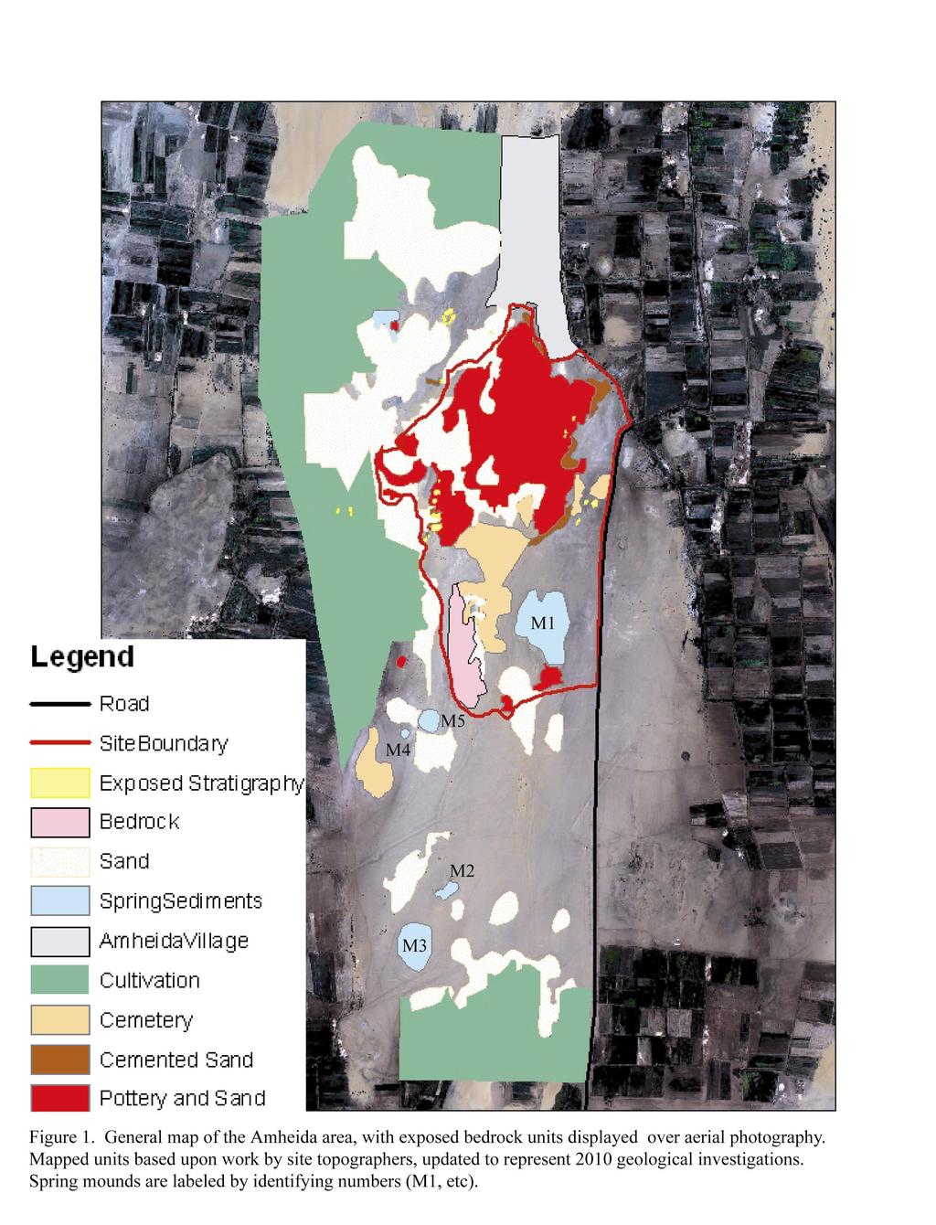
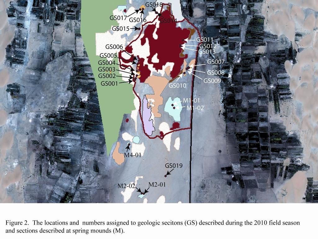
1 New York University Excavations at Amheida 2010 Geological Investigations LOCAL GEOLOGY The geology of the Amheida area has been outlined previously by the site topographers; the general geomorphology and location of most exposed units has been identified with great accuracy. The description that follows is based upon observations during the 2010 season that have built upon, and in some cases have slightly altered the details of, this previous work. It should be noted that a Munsell color chart was not available during this survey, and colors are therefore described as closely as possible based on observer bias. In addition, because the region of Amheida is one of active dune activity, local geology has been described as best as possible using current sedimentary exposures. Future dune movements may provide additional opportunities to describe and correlate local outcrops. Also, this field report reflects initial data and impressions at the end of the 2010 season, which are subject to revision through additional data collection and analysis. Topographically, the Temple and associated occupation areas at Amheida form a local high point. Surrounding land surfaces are lower but also exhibit variable geomorphologies and degrees of erosion. Beyond the Temple mound, local high points tend to be either spring mounds or exposures of local sedimentary units (Figure 1). In some cases it is difficult to distinguish between these two types of sediment from geomorphology alone, as the formation of yardangs and the degradation of previous deposits may take a variety of forms. For this reason, ground-truthing of presumed spring mound environments has revealed regular stratigraphy instead of spring sediments in two different areas around the site. Geologic survey during 2010 revealed a fairly regular stratigraphy present where outcrops have been preserved. Generally, a series of cemented dune deposits (paleodunes) exist beneath and between silty deposits and localized evidence for standing freshwater. Elevations taken on these deposits match the elevations provided for sub-excavation cemented sand deposits (approximately m asl), which supports the hypothesis that exposed outcrops outside the excavation area represent the stratigraphy beneath the Temple mound as well. Observations of the modern surface surrounding the excavation areas also reveal paleodune deposits forming the modern land surface, which is again confirmation that remnant outcrops reveal a regional stratigraphy that continues beneath and beyond the Temple mound. In an effort to correlate these stratigraphic units and provide a more detailed view of the environments represented by these sediments, geologic sections (GS, Figure 2) were described and drawn at a number of locales in and around Amheida. 1
2 STRATIGRAPHY Southwest (GS001-GS006) Several outcrops to the SW of the site proper (Figure 1) provide excellent exposures of the subsurface deposits and provide a small area for the correlation of stratigraphic units (Figures 2, 3). The basal unit exposed in some of these sections is well-sorted medium sand with limited fabric preservation, as significant biogenic overprinting has occurred since the original deposition of this sand. Root casts and burrows are common, but the sorting of the sand as well as the overlying deposits suggest that this unit represents a dune environment. Pottery found in situ and some small pieces of charcoal in this unit provide evidence for occupation within or on this unit, which may provide a means for dating this early dune environment through radiocarbon or relative dating via pottery fabric. Above this occupied dune unit are a number of additional dune units, some with excellent cross-bedding and all composed of well-sorted medium to fine sand. Root traces are common, and several paleosurfaces can be identified via erosional (wavy) surfaces and the presence of mudcracks. The specific units present within each section vary, which is to be expected given the variable progression of dune deposits. Above these dune deposits, there is sometimes preserved a moderately sorted, medium to fine sand with abundant bioturbation and root traces. This unit contains abundant gastropods of the species Melanoides tuberculata as well as at least two additional gastropod species, and pottery is also abundant. The presence of the gastropods in particular is indicative of standing freshwater, and the abundance of pottery suggests heavy human use of this area during this period. The presence of some pottery in the unit below may be indicate related occupation of upper dune units, and the presence of charcoal again may provide a means for dating this unit if relative dating of pottery does not provide an accurate date. Above this freshwater deposit is another dune-sand, which sits below a unit composed of very fine silt to clay with well-developed angular-blocky peds, root traces, biopores and variable oxidation staining. The color of this unit is very similar to the Mut bedrock found elsewhere in the oasis, a reddish-purple. There is pottery within this silty layer in some areas. Above this silt is yet another cross-bedded dune deposit that contains woody material in some areas. Finally, the cap of several outcrops consists of another silt/clay unit with ped formation, root traces, biopores and oxidation staining. This top unit in particular is extremely chunky and almost seems out of place or transported in some areas, with sand filling in around 2
3 peds. Coloration is again a reddish-purple, with some areas of more gleyed greenish-gray. Charcoal is present as displaced pieces in at least one area within this unit. The two silty layers, and in particular the well-developed peds found within them, indicate that these fine-grained units may represent paleosols, which would in turn indicate the presence of stable land surfaces in this area for relatively long periods of time, separated by a period of dune formation. The source of the silt is difficult to determine, though it may have accumulated during a period of slower erosion and increased vegetation. The similarity between these silts and the Mut formation may indicate that these units represent reworked Mut shales. A comparison between current bedrock and these units may clarify the degree to which these units are actually similar to bedrock. Stratigraphic investigations of these outcrops (GS001-GS006) reveal occupation surfaces older than those currently under investigation, which may aid in the determination of the timing of paleodune and silt deposition. In addition, the close spacing of these six outcrops provided an opportunity for small-scale investigation into the paleoenvironments that preceded Roman occupation at Amheida, which are unsurprisingly punctuated by dune formation and movement. However, the evidence for stable surfaces and standing freshwater may provide additional insights into the hydrologic and geomorphologic history of the Amheida area, even if these deposits are too old to provide much information relevant to current excavations. A secondary goal of the detailed descriptions provided here is to provide an understanding of the local stratigraphy and the extent to which the described units are representative of the geology of the Amheida area as a whole. With this goal in mind, additional sections were described in other areas of outcrop to the southeast and north of the Amheida excavations. Southeast (GS007-GS010) To the southeast of the Temple hill (Figure 2), two large hills reveal the same general stratigraphy found to the southwest. For both of these hills, the lower-most slope is covered by significant slope wash. Because an effort is being made to avoid significant digging or disturbance of potentially archaeological deposits on the Amheida site proper, minimal cleaning of this slope wash means that the stratigraphy has been reconstructed using minimal sedimentary exposures. The details of the units making up the bottom half of these sections should therefore not be taken as complete. It may be prudent to obtain permission to clear sections on these hills in the future in order to obtain a more accurate sedimentary description. The eastern-most hill, described as GS007, and reveals a significant thickness of dune sand deposits. Limited exposure reveals cross-beds as well as the presence of flakes of shale and leaf 3
4 litter preserved in the upper portion of the cross-bedded laminations. On top of this sand is bioturbated fine silt found in chunks that could be well-developed peds. These chunks of silt are often sandy on their surfaces and look like they have been transported or otherwise disturbed (conglomeratic). A thin sand unit separates two such units, similar to those found to the SW except that in this case they do not look like they are in place. It is possible that the nature of the weathering of these pedogenic horizons has resulted in deposits that have been heaved and broken to the extent that they look transported. The stratigraphic context of these units and its similarity to that found elsewhere supports the idea of in situ silts, although it is also possible that these silt units were transported in this portion of the site during the same periods that they could be found in situ elsewhere. The second hill, to the west of GS007, exhibits enough variation that two sections were measured. GS008 was measured on the northern side of the hill, and reveals a similar stratigraphy to GS007 except for a small area of Interbedded silt/clay and sand approximately 1.8 m above the modern surface. This unit pinches out to the south in this hill, and is not found on the eastern hill. Sand units in GS008 also contain shale flakes, and sit beneath conglomeratic silts. Farther to the south along this same outcrop, and additional section, GS009, reveals a slight variation in the upper stratigraphy. The lower units here were largely covered by slope wash, although a single piece of pottery was seen within the dune deposit. At the top, massive sand units are interbedded with chunky silts that break into subangular blocky peds and contain root traces. The top of this section is composed of a very colorful medium sand in black, orange, yellow and red. Gray silts are also present. This upper unit and the silts directly below it have a sulfurous smell to them when pieces are broken open. The very local nature of this sandy unit as well as its significant oxidation and sulfurous smell support the presence of a spring vent on the southern portion of this hill, which would have altered the local stratigraphy in the immediate area of water discharge. There is a similarly localized patch of colorful coarser sand on the eastern hill, which again may indicate spring activity. Additional excavation into the tops and sides of these hills may reveal the presence of spring vents, though given the elevation of these units it is likely that any spring activity here would pre-date the time period of current interest to the Amheida excavations. An isolated yardang present to the south of these large hills provides yet another outcrop, here described as GS010. A similar stratigraphy is revealed, although in this case the cross-bedding of lower dune sands is more obvious. Unit three contains some inclusions of sandy silt, presumably a portion of the upper-most unit here. Shale inclusions are also present in the upper-most sand, providing a correlation with the cross-bedded, shale-containing sands to the north. Finally, the uppermost unit here is again conglomeratic silt to fine sand, primarily of a pinkish color but more 4
5 grayish-green is found toward the top of the unit. Chunks are subangular blocky with root traces when they are broken open. In this case there is no question whether this unit has been transported, as a ~10 cm. piece of limestone was present within the jumble of silt chunks. The regularity of the stratigraphy across this southern portion of the Amheida site suggests a predictable basement beneath the occupation, and may also provide a means for determining the relative ages of various units found at the site. The transport of the upper silty units to the SE of the Temple mound is not currently well-understood. It may be that spring activation provided localized flows that transported silty units as peds without changing the overall stratigraphy. Further investigations of these units may be necessary to understand the history of their deposition. East (GS011-GS013) Stratigraphic exposures closer to the Temple mound and to the north of the site provide additional evidence that the stratigraphy described thus far continues beneath the site and throughout the immediate area. Three areas of stratigraphic exposure quite close to the excavation area reveal bioturbated, cross-bedded sands topped by silt deposits very similar to those found to the southeast of the site boundary. Dune sands sometimes include shale flakes, and here also the uppermost silty deposits look transported, with blocks of well-consolidated silt piled and loosely aggregated. The interface between sand and silt is rich in pottery, again suggesting an occupational surface within the uppermost dune layers or upon the surface represented by the dune deposits (Figures 2, 4). Collection of these materials, and potentially the clearing of better sections here, may elucidate finer-scale details regarding environmental change or the nature and timing of this occupational layer. North (GS014-GS018) Areas to the north and northwest of the site are difficult to see, due to extensive ground coverage by modern dune sands as well as the presence of Amheida Village. A few yardangs (GS014, GS015, and GS018) were described in order to examine the cemented sand in this portion of the site (Figure 5). These sections indicate that the dune deposits hidden under slope wash in other areas (GS007-GS009 in particular) may contain microstratigraphic details that are difficult to discern without clear exposures of sediment. Cross-bedded dune sands in these sections are variably cross-bedded and bioturbated, with a single exposure of a pebbly sand which may indicate limited water-related transport. The limited extent of these deposits makes this information of limited interest from a paleoenvironmental perspective, but the presence of these cemented sands to 5
6 the north and northwest does support the idea of paleodune environments as the sub-occupation surface and the bedrock beneath the Temple Mound. GS016 and GS017 were sections described within a series of mounded deposits that form a rough circle on the northeast side of the site (Figure 2). Although it was originally thought that these deposits might represent a spring mound, they instead reveal a similar stratigraphy to that found to the southeast at GS007 and GS008. Cross-bedded sands contain gray shale flakes and are overlain by silty deposits. The basal sands contained some pottery and charcoal as well, suggesting a potential link with the basal dune deposits found to the SW (GS001-GS006). The silty deposits capping GS016 and GS017 are variably pinkish to greenish-gray, and are not clearly in place, though they do not look as well-transported as those found to the southeast of the site. South (GS019) Digging was avoided during the current season, but in one instance a two-meter pit was discovered dug into the surface just north of the Second Pyramid (M2). This opportunity to investigate sub-surface deposits to the south revealed the presence of fluvial gravels in at least two individual units separated by an erosional boundary. These units sit on Mut Formation bedrock. The occurrence of fluvial deposits so close to obviously fluvial deposits associated with Spring Mound 2 (see below) is not particularly surprising, but the relationship between these deposits and anything described farther north is currently unknown. The surface of the southern plain is covered in most places in a lag of silica gravel, which is likely sourced within the fluvial gravels described at GS019. This surface lag disappears on the south side of M1, just at the boundary of the site proper. The placement of this lag deposit may indicate areas of subsurface fluvial gravels; in this case fluvial activity would have affected only the southernmost portions of the area so far examined. A second possibility is that these fluvial gravels naturally underlie dune deposits throughout this area, and that moving north brings us up-section into the dune deposits. Other possibilities include land use within the site boundary removing any fluvial deposits. Only additional subsurface stratigraphic investigations will reveal answers to these questions. 6
7 SPRING MOUNDS M1 The first spring mound examined within the Amheida area was the large horseshoe-shaped mound to the southeast of the site. The horseshoe itself seems to be composed of ironstone and sand, and may indicate an older and more extensive period of spring activation. Within the central horseshoe are much lower ridges of colorful sand, which preserves ceramics. These small ridges, one on each side of a central pile of vegetation-collected sand, were described as M1-01 to the west and M1-02 to the east. The various sandy units are consistent with spring-deposited sands found elsewhere in the oasis, and the presence of pottery within the sediment suggests that this spring was active during some period of human use of the area. A general age on the pottery may provide insights into the exact timing of this activation. The southeastern extension of this horseshoe mound seems to be composed of a second spring eye, with a higher concentration of ironstone and more consolidated sediment. No pottery or other material is present here to suggest an age of activation, but the higher elevation of these sediments suggest that it may represent an older period of spring activity than the sands described as M1-01 and M1-02. M2 The second spring mound to be described in 2010, and therefore the mound designated as M2, is farther south and is the site of a tomb known as the Second Pyramid. This mound exposes a large central area that may have contained a vent of some sort. The sediment exposed on the sides of the interior of the vent is at the base variably oxidized and very colorful, containing yellow, red, and orange sediments. Silt and silty inclusions are present, supporting deposition by water as well as the presence of groundwater activation these basal deposits are identical to springdeposited silts and sands found elsewhere in the oasis. Above these obviously spring-related sediments is a significant thickness of oxidized, purplish fluvial sand and gravel, all highly bioturbated and indicative of flowing water. The source of the fluvial water may have been this spring itself, but the deposits are poorly sorted and course, indicating water flow. Elsewhere there are masses of iron-cemented root casts and other evidence of a highly vegetated area, supporting the presence of surface water. The spring activity here may have been the source of both the deposits exposed at this spring mound, and additionally may have been the water source for fluvial deposition elsewhere in this 7
8 southern plain. The activity of a spring here may explain the fluvial deposits at GS019, for example, making a stronger case for significant groundwater flow at some point in the past. The presence of the tomb built high on the side of the mound suggests that spring activity predated the related occupational period, but any finer dating would be difficult without organic matter for radiocarbon dating or artifacts found in situ in fluvial deposits. M3 Mound 3 is a large pile of sand and ironstone to the south of M2. Very little sediment is visible, though there is a small exposure of yellow and orange sediment that is likely spring-related. Additional information may require the clearing of a stratigraphic section. M4 M4 is a relatively small but round feature, with a depression in the center that may represent a spring vent. Infilling sand makes it difficult to determine what may be present in the center, but an exposure along the raised side was described as M4-01 (Figure 2). These sediments are water-lain, with highly and variably oxidized spring-related sediments as a cap. These sediments support M4 as a spring-related deposit beyond its suggestive morphology. M5 Mound 5 is slightly larger than M4, to the northeast. It has a similar round morphology with a depression in the center, but exposed sediments are more variable. Cemented cross-bedded sands along the edges of M5 are well-sorted and suggest a dune environment, whereas sands found within the depression (potentially a vent) contain silty chunks and a lag of Melanoides tuberculata. Along the eastern edge of the mound are salt-cemented sands underlain by iron-cemented sand. These deposits suggest standing freshwater and evaporative conditions, with variable cement potentially determined by the variable influence of groundwater flow. While excavation would reveal a more useful stratigraphy, the surface expression of these deposits supports spring activity at M5 at some point in the past. 8
9 Spring Mounds as Water Sources The investigations undertaken thus far at Amheida suggest that there are a number of springrelated deposits surrounding the site. The difficulty with spring mounds of this sort is that they may have been active at almost any time in the past, and any given spring mound not necessarily have been active at the same time as others. The mounded nature of the deposits is generally the result of the erosion of previously isolated deposits; presumably the more resistant iron-rich sediments deposited by the groundwater stood up to erosion far better than the surrounding landscape, resulting in mounds on the modern surface. The presence of a spring mound therefore tells us that groundwater-related deposition occurred in this place, but doesn t necessarily reveal the vent source of this water or the timing of spring activity. There is some evidence of re-activation of springs. At M1 in particular, the elevation of the horseshoe is much higher than that of the sandy deposits that contain pottery. It seems that this area was subject to groundwater flow at some time in the distant past, followed by the lowering of the landscape and reactivation of flow more recently. Multiple periods of groundwater flow may have been initiated by climatic conditions in the region. However, it is difficult to say when any given mound may have been active unless we find direct evidence in the form of artifacts or architecture. It is worth noting that many of the regular stratigraphy deposits described here, particularly GS017 and GS016, take the same erosional form as some of the spring-related deposits. This supports the idea that the modern form of spring deposits is related to erosional processes, and less dependent upon the nature of spring deposition and flow. It also suggests that ground-truthing will be required for the identification of any sediment, regardless of its morphological expression. OTHER OBSERVATIONS Limestone Gravel A pile of gravel found near what has been magnetically interpreted as an area of pottery kilns (just south of GS009) is composed primarily of limestone, with some mudstone and chert present as well. All of these clasts are at minimum moderately rounded, and they are coated with a black substance on surfaces that face the interior of the pile. Even minimal digging into this gravel was avoided at present, but a limestone fossil of a marine bivalve was present in the surface gravel. Similar marine fossils can be found in the capping limestones on the Libyan Plateau to the north, 9
10 which implies a Plateau source for the gravel pile. It should also be noted that some small piles of limestone can be found to the north of this area, closer to the road, and that a crushed gravel unit is commonly used as a subsurface before paving in this area (see road at entrance to site). Although these other limestone piles do not exhibit the same black coating, it may be prudent to investigate the possibility of a more recent source for this gravel pile. Channeled Lands and Construction Slightly south of GS009 and the limestone gravel described above, a series of channels have been dug into the land surface. While it is difficult to determine the extent to which erosion has affected the current land surface in some areas, the channeled land here may have been associated with irrigation at some point in the past. One intriguing feature in this area is a linear construction of mud built across two channels running N-S. Within this construction, a grass mat has been preserved within the mud mixture. The dating of this feature may provide some limitations in terms of when these channels were created and utilized in the past. This area has been identified by previous magnetometry survey as an area of pottery production; it would be interesting to pursue specific investigations of the usage of this portion of the site and the extent to which water use and pottery production may have been linked. Preliminary Investigations: SE and E Initial and limited investigations to the southeast of the site (east of the road, across from M2/Second Pyramid) suggest an area of uplifted Taref Formation sandstone and a visible (due to modern activities involving bulldozers) fault surfaces. This uplifted area was previously visited by Professor Ellen Morris, and contains scatters of paleolithic materials as well as carvings within the sandstone. In addition, there is evidence of at least two small basins where groundwater ponding occurred. The silica gravel in this area consists of pieces very similar to, but much larger than, that found throughout the southern portion of the study area to the west of the road, which suggests that this area may be a source of that gravel or at least is closer to that source than areas farther west. Detailed investigations of this area would be suggested for future seasons. East of the road farther north, there are several large mounds. At least one of these is a spring mound, and one other is composed of fluvial deposits that contain pottery. Another mound seems to expose the regular dune-beneath-silt stratigraphy found elsewhere during the 2010 season. Detailed stratigraphy of these deposits should be included in plans for future investigations. 10
11 DISCUSSION AND CONCLUSIONS Investigations into local stratigraphy have revealed evidence for occupation within dune/interdune environments, which likely predate Roman occupation at the site by a significant margin. Although there is evidence for standing freshwater as well as active spring discharge within the local area, preliminary opinions on the age of the pottery found within these deposits suggest that all evidence for surface water found thus far is relevant to periods much older than the Roman period of interest. One of the more curious aspects of the local stratigraphy is the extent to which we find a regular sequence of dune sands beneath silts, while those silts seem variably disturbed. The variety of colors found within these silt units is also notable in the more in situ deposits the color is a purplish red, very similar to the color of the local Mut siltstone bedrock. In those areas where these deposits look transported, the color is more frequently a greenish color. This coloration is also seen within the Mut bedrock but only along fissures and within spring mounds, presumably as a result of contact with groundwater. It is therefore possible that the color change supports the idea of waterrelated transport of these silty deposits, which may correlate with the in situ units found elsewhere. This would suggest localized reworking of silt deposits within very limited time frames, so that silt was reworked on the same land surface where it can be found in place. Regardless of the specific environmental origin of these silt deposits, the regularity of the stratigraphy surrounding the Temple Mound suggests that the visible outcrops are in fact revealing the original stratigraphy of the area. This hypothesis is supported by the fact that excavations found cemented sandstone at an elevation of meters above sea level (asl) beneath the Temple Mound, which matches perfectly with the elevations taken on sandstone units southeast of the site (GS001-GS006, see Figures 2 and 3). Sandstone beneath silts therefore appears to be the general stratigraphy of the area immediately surrounding the Amheida site proper, though the specific location of interdune freshwater deposits may be localized and difficult to determine without extremely clear stratigraphic exposures. Overall, the 2010 geologic investigations at Amheida reveal a number of directions for potential future research at the site (see additional document), and indicate that the work done thus far in the area has been of high quality, providing a useful basis for the current study. Future work will hopefully elucidate sedimentary details in the deposits already examined while expanding the range of geologic investigations into areas farther east and north. Katherine A. Adelsberger 11
12 12
13
14
15
16 16
Sediment and sedimentary rocks Sediment
 Sediment and sedimentary rocks Sediment From sediments to sedimentary rocks (transportation, deposition, preservation and lithification) Types of sedimentary rocks (clastic, chemical and organic) Sedimentary
SUPPLEMENTAL MATERIAL
 SUPPLEMENTAL MATERIAL DESCRIPTIONS OF OTHER STRATIGRAPHIC SECTIONS Cherry Creek In its middle reaches, Cherry Creek meanders between three paired terraces within a narrow bedrock valley. The highest is
Starting at Rock Bottom
 Starting at Rock Bottom At rock bottom of the Brushy Creek site s geological column lies the first clue to human habitation: A smelting and heattreating furnace, and mold, carved into Bed Ked: Figure 15
Sand. Sand is any eroded material (igneous, metamorphic or sedimentary) that has a grain size from 1/16 th to 2 millimeters in size.
 that has a grain size from 1/16 th to 2 millimeters in size.") Sedimentology 001 What is sedimentology? Sedimentology...encompasses the study of modern sediments such as sand [1], mud (silt) [2] andclay [3] and understanding the processes that deposit them.[4] It
Sedimentology 001 What is sedimentology? Sedimentology...encompasses the study of modern sediments such as sand [1], mud (silt) [2] andclay [3] and understanding the processes that deposit them.[4] It
GLG Chapter 7 Sedimentary Environments & Rocks
 GLG 101 - Chapter 7 Sedimentary Environments & Rocks Name Note, Oct 11: I ll be writing this study sheet over the next few days. Each day I will add questions until the entire chapter is done, hopefully
 UNIT DESCRIPTIONS: Artificial Fill, Undocumented (Afu): Locally derived sandy silt and silty sand, locally with clay and varying amounts of gravel and man-made debris. Abundant concrete rubble, in places
Geology 252, Historical Geology, California State University, Los Angeles - professor: Dr. Alessandro Grippo
 LAB # 1 - CLASTIC ROCKS Background: - Mechanical and Chemical Weathering - Production of Clastic Sediment - Classification of Sediment according to size: Gravel, Sand, Silt, Clay - Erosion, Transportation
Sedimentary Rocks. Origin, Properties and Identification. Physical Geology GEOL 100. Ray Rector - Instructor
 Sedimentary Rocks Origin, Properties and Identification Physical Geology GEOL 100 Ray Rector - Instructor Sedimentary Rock Origin and Identification Lab Pre-Lab Internet Link Resources 1) http://www.rockhounds.com/rockshop/rockkey/index.html
Lab 7: Sedimentary Structures
 Name: Lab 7: Sedimentary Structures Sedimentary rocks account for a negligibly small fraction of Earth s mass, yet they are commonly encountered because the processes that form them are ubiquitous in the
Sedimentary Rocks. Origin, Properties and Identification. Geology Laboratory GEOL 101 Lab Ray Rector - Instructor
 Sedimentary Rocks Origin, Properties and Identification Geology Laboratory GEOL 101 Lab Ray Rector - Instructor Sedimentary Rock Origin and Identification Lab Pre-Lab Internet Link Resources 1) http://www.rockhounds.com/rockshop/rockkey/index.html
Chapter 6 Pages of Earth s Past: Sedimentary Rocks
 Chapter 6 Pages of Earth s Past: Sedimentary Rocks Introduction! Drilling into the bottom of the North Sea, we encounter: " Soft mud and loose sand, silt, pebbles, and shells. Then: " Similar materials
=%REPORT RECONNAISSANCE OF CHISHOLM LAKE PROSPECT. October 25, 1977
 =%REPORT ON FIELD RECONNAISSANCE OF CHISHOLM LAKE PROSPECT October 25, 1977 Bruce D. Vincent Imperial Oil Limited, Minerals - Coal, CALGARY, ALBERTA CHISHOLM LAKE PROSPECT Introduction The Chisholm Lake
Feet. SAND; clayey, fine grained; shells are common; rounded quartz grains. SHELLS; muddy; almost no sand, shells and fragments common
 SAND; clayey, fine grained; shells are common; rounded quartz grains SHELLS; muddy; almost no sand, shells and fragments common SAND; back to medium to fine; has a mottled appearance and looks burrowed;
Correlation of gravel deposits from trenching project on Alder Creek fluvial terrace near Point Arena, California
 Correlation of gravel deposits from trenching project on Alder Creek fluvial terrace near Point Arena, California Aletha Lee Department of Geology and Geography, West Virginia University, White Hall, Morgantown,
ROCK CLASSIFICATION AND IDENTIFICATION
 Name: Miramar College Grade: GEOL 101 - Physical Geology Laboratory SEDIMENTARY ROCK CLASSIFICATION AND IDENTIFICATION PRELAB SECTION To be completed before labs starts: I. Introduction & Purpose: The
A study of the variation in the Rooikoppie gravels in the Lower Vaal area
 A study of the variation in the Rooikoppie gravels in the Lower Vaal area A study of the variation in the Rooikoppie gravels in the Lower Vaal area M. Ndwammbi Rockwell Diamonds Inc The Rooikoppie gravel
Geo 302D: Age of Dinosaurs. LAB 2: Sedimentary rocks and processes
 Geo 302D: Age of Dinosaurs LAB 2: Sedimentary rocks and processes Last week we covered the basic types of rocks and the rock cycle. This lab concentrates on sedimentary rocks. Sedimentary rocks have special
Your web browser (Safari 7) is out of date. For more security, comfort and the best experience on this site: Update your browser Ignore
 is out of date. For more security, comfort and the best experience on this site: Update your browser Ignore") Your web browser (Safari 7) is out of date. For more security, comfort and the best experience on this site: Update your browser Ignore BEDRO CK For the complete encyclopedic entry with media resources,
Your web browser (Safari 7) is out of date. For more security, comfort and the best experience on this site: Update your browser Ignore BEDRO CK For the complete encyclopedic entry with media resources,
Sedimentary Rocks. Origin, Properties and Identification. Physical Geology GEOL 101 Lab Ray Rector - Instructor
 Sedimentary Rocks Origin, Properties and Identification Physical Geology GEOL 101 Lab Ray Rector - Instructor Sedimentary Rock Origin and Identification Lab Pre-Lab Internet Link Resources 1) http://www.rockhounds.com/rockshop/rockkey/index.html
DATA REPOSITORY FIGURES AND TABLES
 GSA Data Repository Item 2016322 Sweeney, K.E., and Roering, J.J., 2016, Rapid fluvial incision of a late Holocene lava flow: Insights from lidar, alluvial stratigraphy, and numerical modeling: GSA Bulletin,
Feet. Cape May Core #51 Start depth: 240 ft Stop depth: 245 ft Recovery (ft): 5.1 ft Date: 3/21/94 Described by: JVB, KGM, CL. 5.
: 5.1 ft Date: 3/21/94 Described by: JVB, KGM, CL. 5.") SAND; medium to fine sand with abundant silt, homogenous slightly mottled appearance; mica on outside, mostly quartz; few darks; peat layer.9 - ft; cnv - same as above; the last few cores are all the same;
SAND; medium to fine sand with abundant silt, homogenous slightly mottled appearance; mica on outside, mostly quartz; few darks; peat layer.9 - ft; cnv - same as above; the last few cores are all the same;
Lecture Outline Wednesday - Friday February 14-16, 2018
 Lecture Outline Wednesday - Friday February 14-16, 2018 Quiz 2 scheduled for Friday Feb 23 (Interlude B, Chapters 6,7) Questions? Chapter 6 Pages of the Past: Sedimentary Rocks Key Points for today Be
Paleo Lab #4 - Sedimentary Environments
 Paleo Lab #4 - Sedimentary Environments page - 1. CHARACTERISTICS OF SEDIMENT Grain size and grain shape: The sizes and shapes of sedimentary particles (grains) are modified considerably during their transportation
EPS 50 Lab 4: Sedimentary Rocks
 Name: EPS 50 Lab 4: Sedimentary Rocks Grotzinger and Jordan, Chapter 5 Introduction In this lab we will classify sedimentary rocks and investigate the relationship between environmental conditions and
Sediment. Weathering: mechanical and chemical decomposition and disintegration of rock and minerals at the surface
 Sediment Some basic terminology Weathering: mechanical and chemical decomposition and disintegration of rock and minerals at the surface Erosion: removal of weathered rock and minerals from one place to
Bowen s Chemical Stability Series
 Lab 5 - Identification of Sedimentary Rocks Page - Introduction Sedimentary rocks are the second great rock group. Although they make up only a small percentage of the rocks in the earth s crust (~5%)
Name. 4. The diagram below shows a soil profile formed in an area of granite bedrock. Four different soil horizons, A, B, C, and D, are shown.
 Name 1. In the cross section of the hill shown below, which rock units are probably most resistant to weathering? 4. The diagram below shows a soil profile formed in an area of granite bedrock. Four different
Cretaceous, Dakota Formation, Terra Cotta Member South Side of I-70, Salina County, Kansas
 Cretaceous, Dakota Formation, Terra Cotta Member South Side of I-70, Salina County, Kansas Written By: Steven D.J. Baumann G-102010-1A Outcrop looking southeast Photo taken by: Steven Baumann on 10-20-2010
ESC102. Sedimentary Rocks. Our keys to the past. Monday, February 11, 13
 ESC102 Sedimentary Rocks Our keys to the past Sedimentary Rocks Sedimentary rocks are rocks that form through the accumulation of sediment and the process of lithification. Lithification occurs after deposition
Data Repository item DATA REPOSITORY
 Data Repository item 2003053 1 DATA REPOSITORY Stable isotope and trace-element geochemistry of the basal Bouse Formation carbonate, southwestern USA: Implications for the Pliocene uplift history of the
Pratice Surface Processes Test
 1. The cross section below shows the movement of wind-driven sand particles that strike a partly exposed basalt cobble located at the surface of a windy desert. Which cross section best represents the
Sedimentary Rocks. All sedimentary rocks begin to form when existing rocks are broken down into sediments Sediments are mainly weathered debris
 Rocks! Objectives Describe the major processes involved in the formation of sedimentary rock Distinguish between clastic sedimentary rocks and chemical sedimentary rocks Identify the features that are
Coso Red Hill and Coso Playa field trip, Prof. Alessandro Grippo, Ph.D.
 HISTORICAL GEOLOGY fall 2016 Professor: Dr. Alessandro Grippo, Ph.D. FIELD TRIP REPORT: Friday, October 21, 2016: Coso Red Hill & Playa, Coso Junction CA YOUR NAME part 1: COSO RED HILL (you can sample
Clyde River Landslide
 Clyde River Landslide Department of Geology, Perkins Hall, University of Vermont, Burlington, VT 05405 Abstract: This paper investigates a landslide on the Clyde River in Newport, Vermont. The landslide
Data Repository item
 Data Repository (B25407): Localities and descriptions of measured sections of study areas Table 1. Localities of the measured sedimentary sections in the NW Sichuan Basin Section Number Stratigraphy Locality
Sediment and Sedimentary rock
 Sediment and Sedimentary rock Sediment: An accumulation of loose mineral grains, such as boulders, pebbles, sand, silt or mud, which are not cemented together. Mechanical and chemical weathering produces
Sedimentary Rocks, Stratigraphy, and Geologic Time
 Sedimentary Rocks, Stratigraphy, and Geologic Time A rock is any naturally formed, nonliving, coherent aggregate mass of solid matter that constitutes part of a planet, asteroid, moon, or other planetary
Table 9. FAI accession log
 Table 9. FAI-02045 accession log UA Accession # FS # Depth (cm BS) Artifact Type n= Material Color UA2010-187-0001 1 5-10 utilized flake 1 basalt black UA2010-187-0002 2 5-10 flake 1 chert black UA2010-187-0003
LAB 6: TRINIDAD BEACH FIELD TRIP
 OBJECTIVES: LAB 6: TRINIDAD BEACH FIELD TRIP 1) to develop your powers of observation, especially of geological phenomena; 2) to identify the rocks exposed at Trinidad Beach; 3) to reconstruct some of
Ecoregions Glossary. 7.8B: Changes To Texas Land Earth and Space
 Ecoregions Glossary Ecoregions The term ecoregions was developed by combining the terms ecology and region. Ecology is the study of the interrelationship of organisms and their environments. The term,
Mud Sand Gravel. Clastic Textures
 Sed Rocks Self-Instruction Lab Name Geology 100 Harbor Section Please see the questions online before you begin. Sedimentary rocks are usually identified in the field by their stratification or layering,
Mud Sand Gravel. Clastic Textures
 Sed Rocks Self-Instruction Lab Name Geology 100 Harbor Section Read the sedimentary rocks chapter before you start. Sedimentary rocks are usually identified in the field by their stratification or layering,
4. The map below shows a meandering stream. Points A, B, C, and D represent locations along the stream bottom.
 1. Sediment is deposited as a river enters a lake because the A) velocity of the river decreases B) force of gravity decreases C) volume of water increases D) slope of the river increases 2. Which diagram
Module 9 Sedimentary Rocks
 Module 9 Sedimentary Rocks SEDIMENTARY ROCKS Rocks formed from material derived from preexisting rocks by surfacial processes followed by diagenesis There are two main classes of sedimentary rocks Clastic
13. Sedimentary Rocks I (p )
") 13. Sedimentary Rocks I (p. 194-208) Sediment Deposition Weathering results in rock being broken down into smaller fragments, called regolith. This regolith is then broken down to form soil. The regolith
13. Sedimentary Rocks I (p. 194-208) Sediment Deposition Weathering results in rock being broken down into smaller fragments, called regolith. This regolith is then broken down to form soil. The regolith
GEOLOGY MEDIA SUITE Chapter 5
 UNDERSTANDING EARTH, SIXTH EDITION GROTZINGER JORDAN GEOLOGY MEDIA SUITE Chapter 5 Sedimentation Rocks Formed by Surface Processes 2010 W.H. Freeman and Company Mineralogy of sandstones Key Figure 5.12
NC Earth Science Essential Standards
 NC Earth Science Essential Standards EEn. 2.1 Explain how processes and forces affect the Lithosphere. EEn. 2.1.1 Explain how the rock cycle, plate tectonics, volcanoes, and earthquakes impact the Lithosphere.
UNIT 4 SEDIMENTARY ROCKS
 UNIT 4 SEDIMENTARY ROCKS WHAT ARE SEDIMENTS Sediments are loose Earth materials (unconsolidated materials) such as sand which are transported by the action of water, wind, glacial ice and gravity. These
GeoCanada 2010 Working with the Earth
 Lithofacies Identification and the Implications for SAGD Well Planning in the McMurray Formation, Christina Lake Area, Alberta Travis Shackleton*, Robert Gardner, Sung Youn, Grace Eng and Lori Barth Cenovus
Section I: Multiple Choice Select the best answer to each question. Mark your final answer on the answer sheet. (1 pt each)
") Sedimentary Rocks & Surface Processes Quest Name: Earth Science 2013 Block: Date: Section I: Multiple Choice Select the best answer to each question. Mark your final answer on the answer sheet. (1 pt each)
Sedimentary Rocks & Surface Processes Quest Name: Earth Science 2013 Block: Date: Section I: Multiple Choice Select the best answer to each question. Mark your final answer on the answer sheet. (1 pt each)
Stratigraphy and structure of the Ganson Hill area: northern Taconic Allochthon
 University at Albany, State University of New York Scholars Archive Geology Theses and Dissertations Atmospheric and Environmental Sciences 1985 Stratigraphy and structure of the Ganson Hill area: northern
Sediments and Sedimentary Rocks
 Sediments and Sedimentary Rocks (Shaping Earth s Surface, Part 2) Science 330 Summer 2005 What is a sedimentary rock? Products of mechanical and chemical weathering Account for about 5 percent of Earth
Page 1. Weathering & Erosion by Mass Wasting Pre-Test. Name:
 Weathering & Erosion by Mass Wasting Pre-Test 3048-1 - Page 1 Name: 1) As a particle of sediment in a stream breaks into several smaller pieces, the rate of weathering of the sediment will A) increase
As compaction and cementation of these sediments eventually occur, which area will become siltstone? A) A B) B C) C D) D
 A B) B C) C D) D") 1. A student obtains a cup of quartz sand from a beach. A saltwater solution is poured into the sand and allowed to evaporate. The mineral residue from the saltwater solution cements the sand grains together,
1. A student obtains a cup of quartz sand from a beach. A saltwater solution is poured into the sand and allowed to evaporate. The mineral residue from the saltwater solution cements the sand grains together,
THE CROOKS GAP HOUSEPIT SITE AND OTHER NEARBY MID-HOLOCENE HOUSEPITS
 Volume 56(1 ), Spring 2012 The Wyoming Archaeologist THE CROOKS GAP HOUSEPIT SITE AND OTHER NEARBY MID-HOLOCENE HOUSEPITS by Craig S. Smith Marcia Peterson INTRODUCTION This article summarizes excavation
1. The map below shows a meandering river. A A' is the location of a cross section. The arrows show the direction of the river flow.
 1. The map below shows a meandering river. A A' is the location of a cross section. The arrows show the direction of the river flow. Which cross section best represents the shape of the river bottom at
American Institute of Professional Geologists South Dakota Section
 American Institute of Professional Geologists South Dakota Section 2015 Field Trip Guide Deadwood Formation in the Black Hills of South Dakota and Frac Sand Potential Saturday, September 12, 2015 1 Field
Facies Analysis Of The Reservoir Rocks In The. Sylhet Trough, Bangladesh. Abstract
 Facies Analysis Of The Reservoir Rocks In The Sylhet Trough, Bangladesh Joyanta Dutta Petroleum Geoscience Program, Department of Geology, Faculty of Science, Chulalongkorn University, Bangkok 10330, Thailand
Your teacher will show you a sample or diagram of each, and show you a settling column. Draw these, and label your diagrams (8 pts) Ungraded:
 Ungraded:") From Sand to Stone: How do we recognize and interpret sedimentary rocks in the rock record? (Based closely on the University of Washington ESS 101 Lab 5: Sedimentary Rocks) Introduction: This lab consists
From Sand to Stone: How do we recognize and interpret sedimentary rocks in the rock record? (Based closely on the University of Washington ESS 101 Lab 5: Sedimentary Rocks) Introduction: This lab consists
The physical breakdown and chemical alteration of rocks and minerals at or near Earth s surface.
 The physical breakdown and chemical alteration of rocks and minerals at or near Earth s surface. The material that is chemically and mechanically weathered to yield sediment and soil. Regolith consisting
 27 Figure 7 Poorly cleaved, massive, light-weathering Bomoseen graywacke outcrop located on Brandon Mountain Road. Figure 8 Photomicrograph of Bomoseen graywacke. Subangular, poorly sorted quartz grains
Topic 6: Weathering, Erosion and Erosional-Deposition Systems (workbook p ) Workbook Chapter 4, 5 WEATHERING
 Workbook Chapter 4, 5 WEATHERING") Topic 6: Weathering, Erosion and Erosional-Deposition Systems (workbook p. 95-125) Workbook Chapter 4, 5 THE BIG PICTURE: Weathering, erosion and deposition are processes that cause changes to rock material
Topic 6: Weathering, Erosion and Erosional-Deposition Systems (workbook p. 95-125) Workbook Chapter 4, 5 THE BIG PICTURE: Weathering, erosion and deposition are processes that cause changes to rock material
To get you thinking Explain how these different layers of rock formed? Why are these layers different colors? Sedimentary Rocks
 To get you thinking Explain how these different layers of rock formed? Why are these layers different colors? Sedimentary Rocks Bryce Canyon, Utah Badlands, South Dakota Weathering Whenever rock is exposed
Image: G. Parker. Presenters: Henry Chan, Kayla Ireland, Mara Morgenstern, Jessica Palmer, Megan Scott
 Image: G. Parker Presenters: Henry Chan, Kayla Ireland, Mara Morgenstern, Jessica Palmer, Megan Scott Is the Ross Formation a suitable analog for sand-rich turbidite plays in passive margin basins? Play:
Clastic Textures. I. What is the sorting of sample numbers 60, 61, and 62? Answers on last page.
 Sed Rock s Sel f-instruction N ame Geology 100 Harbor Secti on Sedimentary rocks are usually identified in the field by their stratification or layering, which originates by the successive deposition of
Sedimentary Geology. Strat and Sed, Ch. 1 1
 Sedimentary Geology Strat and Sed, Ch. 1 1 Sedimentology vs. Stratigraphy Sedimentology is the study of the origin and classification of sediments and sedimentary rocks Mostly the physical and chemical
The Nature of Sedimentary Rocks
 The Nature of Sedimentary Rocks Sedimentary rocks are composed of: Fragments of other rocks Chemical precipitates Organic matter or biochemically produced materials The Nature of Sedimentary Rocks Sedimentary
Sedimentary Rocks. Weathering. Mechanical & Chemical Weathering. Sediments. Lithification. Deposition. Transport. Erosion.
 Lithification Sedimentary Rocks Sediments Deposition Transport Erosion Weathering Weathering The sediments that make up sedimentary rocks are produced by: Mechanical & Chemical Weathering Mechanical Weathering
Maine Geologic Facts and Localities October, Lobster Lake, Maine. Text by Robert G. Marvinney. Maine Geological Survey
 Maine Geologic Facts and Localities October, 1998 Lobster Lake, Maine 45 o 51 7.91 N, 69 o 30 53.88 W Text by Robert G. Marvinney, Department of Agriculture, Conservation & Forestry 1 Map by Introduction
UPPER MANZANILLA FORMATION AT FISHING POND VILLAGE FIELDTRIP GUIDE
 UPPER MANZANILLA FORMATION AT FISHING POND VILLAGE FIELDTRIP GUIDE Saturday 10 th March 2012 Trip Leader: Georgia Huggins INTRODUCTION MANZANILLA Formation Author of name: WARING (G.A.) (1926.). The geology
Bulletin of Earth Sciences of Thailand
 Quantitative Seismic Geomorphology of Early Miocene to Pleistocene Fluvial System of Northern Songkhla Basin, Gulf of Thailand Oanh Thi Tran Petroleum Geoscience Program, Department of Geology, Faculty
LINGUAU DEPOSITION IN THE WOODBINE SANDS ALONG COPPERAS BRANCH, DENTON COUNTY. TEXAS: A STUDY IN MARINE SEDIMENTATION
 LINGUAU DEPOSITION IN THE WOODBINE SANDS ALONG COPPERAS BRANCH, DENTON COUNTY. TEXAS: A STUDY IN MARINE SEDIMENTATION Ellis W. Shuler and Olin M. Millican The lack of outcrops in three dimensions often
The Geology of Sebago Lake State Park
 Maine Geologic Facts and Localities September, 2002 43 55 17.46 N, 70 34 13.07 W Text by Robert Johnston, Department of Agriculture, Conservation & Forestry 1 Map by Robert Johnston Introduction Sebago
Sedimentary Rocks, our most Valuable Rocks. Or, what you will probably find when you are outdoors exploring.
 Sedimentary Rocks, our most Valuable Rocks Or, what you will probably find when you are outdoors exploring. Sedimentary rocks give us evidence to earth s earlier history. We look at processes happening
Core Description, Stratigraphic Correlation, and Mapping of Pennsylvanian Strata in the Appalachians
 Core Description, Stratigraphic Correlation, and Mapping of Pennsylvanian Strata in the Appalachians The remaining laboratory sessions for the semester will be collected into a series of exercises designed
Bulletin of Earth Sciences of Thailand
 Depositional Environments and Stratigraphic Development of the Grand Taman Sari Circuit Outcrop: an Analogue for Transgressive Mahakam Delta Successions Ridha Santika Riadi Petroleum Geoscience Program,
Figure 1 The map shows the top view of a meandering stream as it enters a lake. At which points along the stream are erosion and deposition dominant?
 1. In which type of climate does chemical weathering usually occur most rapidly? 1. hot and dry 3. cold and dry 2. hot and wet 4. cold and wet 2. Figure 1 The map shows the top view of a meandering stream
Concretions are accumulation of one or more minerals within the body of a sedimentary rock, or within
 Tibooburra concretions Page 1 Concretions are accumulation of one or more minerals within the body of a sedimentary rock, or within cracks and cavities in a rock. They form when minerals such as quartz,
DOMINANT SEDIMENTS TYPE IN ROCK Loose fragments of rocks or minerals broken off of bedrock Mineral crystals that precipitate directly out of water
 LAST NAME (ALL IN CAPS): FIRST NAME: 7. SEDIMENTARY PROCESSES, ROCKS, AND ENVIRONMENTS Instructions: Refer to Laboratory 6 in your Lab Book on pages 153-186 to answer the questions in this work sheet.
Understanding Earth Fifth Edition
 Understanding Earth Fifth Edition Grotzinger Jordan Press Siever Chapter 5: SEDIMENTATION: Rocks Formed by Surface Processes Lecturer: H Mohammadzadeh Assistant professors, Department of Geology, FUM Copyright
Glacial Geology of Moose Point State Park, ME
 Geologic Site of the Month May, 2013 Glacial Geology of Moose Point State Park, Maine 44 o 25 59.18"N, 68 o 56 37.11"W Text and photos by Woodrow B. Thompson, Department of Agriculture, Conservation &
SOUTH CERRO AZUL STRATIGRAPHIC SECTION. Upper Cerro Azul flow of the Servilleta Basalt (Tsbcau) Lower Sandlin unit (Tsl)
 Lower Sandlin unit (Tsl)") Figure A3-01 cobbles claysilt general grain size sand pebbles vf f m c vc SOUTH CERRO AZUL STRATIGRAPHIC SECTION Top at 18 m. Upper Cerro Azul flow of the Servilleta Basalt (Tsbcau) 15 Basalt: Very dark
Figure A3-01 cobbles claysilt general grain size sand pebbles vf f m c vc SOUTH CERRO AZUL STRATIGRAPHIC SECTION Top at 18 m. Upper Cerro Azul flow of the Servilleta Basalt (Tsbcau) 15 Basalt: Very dark
Location, Location, Location: the Construction and Preservation of Roman Burial Mounds in the Dutch River Delta
 Special Volume 3 (2012), pp. 155 159 Marjolein T.I.J. Bouman Kirsten van Kappel Linda P. Verniers Location, Location, Location: the Construction and Preservation of Roman Burial Mounds in the Dutch River
Surface Processes on the Earth. Rocks, Weathering, Erosion and Soil
 Surface Processes on the Earth Rocks, Weathering, Erosion and Soil ROCKS AND ROCK CYCLE Rock types Three main types of rock Igneous Metamorphic Sedimentary Igneous Form when magma or lava cools and hardens
Surface Processes Focus on Mass Wasting (Chapter 10)
") Surface Processes Focus on Mass Wasting (Chapter 10) 1. What is the distinction between weathering, mass wasting, and erosion? 2. What is the controlling force in mass wasting? What force provides resistance?
Surface Processes Focus on Mass Wasting (Chapter 10) 1. What is the distinction between weathering, mass wasting, and erosion? 2. What is the controlling force in mass wasting? What force provides resistance?
Practice 3rd Quarter Exam Page 1
 Name 1. Which characteristic would most likely remain constant when a limestone cobble is subjected to extensive abrasion? A) shape B) mass C) volume D) composition 2. Which activity demonstrates chemical
Feet CLAY; silty, greenish gray and clayey fine sand; Color: 5Y 3/1
 -. CLAY; silty, greenish gray and clayey fine sand; Color: Y /. -. SAND; fine-medium, clayey, with sandy clay layers; very abundant broken thin, tiny shells; shell hash at several horizons, heavily burrowed;
4.2 Valles Marineris 99
 4.2 Valles Marineris 99 Ganges 2: The ILD (7.4 S/313.1 E) is located in the eastern Valles Marineris (Fig. 2, 10), in Ganges Chasma (Fig. 28), east of Ganges 1 (Fig. 52). Ganges 2 shows a N-S strike, measures
1. Base your answer to the following question on The diagram below represents a part of the crystal structure of the mineral kaolinite.
 1. Base your answer to the following question on The diagram below represents a part of the crystal structure of the mineral kaolinite. An arrangement of atoms such as the one shown in the diagram determines
Soil Development. Soils Sustain Life
 Soil Development Soils Sustain Life Right off the Bat!! A soil is not a geologic deposit, it is a product of in situ weathering. Engineers, archaeologists, and others have learned that anything that is
Nathan D. Webb and James L. Best
 Nathan D. Webb and James L. Best Background Pennsylvanian oil production Stratigraphy & geologic setting Study area Methods Using geophysical logs & core Results Comparing three channel deposits Implications
GEOLOGY OF TODMORDEN MOOR 2 BACKGROUND
 GEOLOGY OF TODMORDEN MOOR 2 BACKGROUND 1) THE CARBONIFEROUS SERIES OF ROCKS The rocks of the Todmorden district are of the Carboniferous Series and were first laid down in an ancient sea, which covered
Page 1. Name:
 Name: 1) Which property would best distinguish sediment deposited by a river from sediment deposited by a glacier? thickness of sediment layers age of fossils found in the sediment mineral composition
Beneath the sand of the Tanami Desert
 Beneath the sand of the Tanami Desert ARGA 2018, Wallaroo, SA Nadir de Souza Kovacs Ngururrpa program The program area covers the traditional land of the Parna Ngururrpa People in a remote part of the
The Welsh Borderland. Geologically recent surface deposits. The Welsh Borderland
 The Welsh Borderland This account provides a broad perspective of the geology of the Welsh Borderland region which comprises the southeast of Powys, southern Shropshire, northern Gwent, the western half
THE CONTACT BETWEEN THE PRECAMBRIAN SHIELD AND THE PHANEROZOIC SEDIMENTARY ROCKS Lab Report (Lab #2) Submitted to: Professor Simone Dumas
 Submitted to: Professor Simone Dumas") THE CONTACT BETWEEN THE PRECAMBRIAN SHIELD AND THE PHANEROZOIC SEDIMENTARY ROCKS Lab Report (Lab #2) Submitted to: Professor Simone Dumas For the course Introduction to Earth Materials (GE01115) By: Gabriella
THE CONTACT BETWEEN THE PRECAMBRIAN SHIELD AND THE PHANEROZOIC SEDIMENTARY ROCKS Lab Report (Lab #2) Submitted to: Professor Simone Dumas For the course Introduction to Earth Materials (GE01115) By: Gabriella
Geo 302D: Age of Dinosaurs. LAB 1: Introduction to Rocks and Sedimentary Processes
 Geo 302D: Age of Dinosaurs LAB 1: Introduction to Rocks and Sedimentary Processes We would not be able to address the interesting questions of dinosaurs and their place in the history of life without the
Sedimentology & Stratigraphy. Thanks to Rob Viens for slides
 Sedimentology & Stratigraphy Thanks to Rob Viens for slides Sedimentology The study of the processes that erode, transport and deposit sediments Sedimentary Petrology The study of the characteristics and
High-resolution Sequence Stratigraphy of the Glauconitic Sandstone, Upper Mannville C Pool, Cessford Field: a Record of Evolving Accommodation
 Page No. 069-1 High-resolution Sequence Stratigraphy of the Glauconitic Sandstone, Upper Mannville C Pool, Cessford Field: a Record of Evolving Accommodation Thérèse Lynch* and John Hopkins, Department