Southeast Offshore Storage Resource Assessment: Opportunities in the Eastern Gulf of Mexico for CO 2 Storage*
|
|
|
- Bernard McCoy
- 6 years ago
- Views:
Transcription
1 Southeast Offshore Storage Resource Assessment: Opportunities in the Eastern Gulf of Mexico for CO 2 Storage* Denise J. Hills 1, Jack C. Pashin 2, and Marcella R. McIntyre-Redden 3 Search and Discovery Article #80543 (2016)** Posted August 8, 2016 *Adapted from oral presentation given at AAPG 2016 Annual Convention and Exhibition, Calgary, Alberta, Canada, June 19-22, 2016 **Datapages 2016 Serial rights given by author. For all other rights contact author directly. 1 Energy Investigations, Geological Survey of Alabama, Tuscaloosa, Alabama, United States (dhills@gsa.state.al.us) 2 Boone Pickens School of Geology, Oklahoma State University, Stillwater, Oklahoma, United States 3 Energy Investigations, Geological Survey of Alabama, Tuscaloosa, Alabama, United States Abstract Subsurface geologic storage of CO 2 (i.e., sequestration) can play a major role in offsetting greenhouse gas emissions in a manner that is safe, economical, and acceptable to the public. While onshore resources have been quantified, no comprehensive assessment of the offshore storage resource in the southeastern United States has yet been performed. The Southeast Offshore Storage Resource Assessment (SOSRA) is designed to fill this gap in knowledge by assessing storage potential in the eastern Gulf of Mexico (EGOM) and along the southeastern seaboard. An estimated 40% of U.S. anthropogenic CO 2 emissions are generated in the southeast, and a large proportion of these emissions are generated within 100 km of the coastline. A preliminary assessment of Miocene strata offshore of Alabama and Mississippi indicates that offshore storage capacity exceeds 200 Gt in these strata alone. Indeed, the EGOM region contains diverse opportunities for geologic storage. Strata deeper than 3,000 m are geopressured; therefore efforts are focusing on Cretaceous-Oligocene strata between 1,000 and 3,000 m. Salt basins in the northwest part of the study area contain large salt-tectonic structures hosting a broad array of storage prospects. The West Florida Shelf spans the southeastern part of the study. The shelf can be characterized as a broad carbonate bank and structurally simple compared to the salt basins. Phase I is underway and is providing an overview of the basic geologic framework of the SOSRA region, identifying potential storage units, and defining the key planning areas. Phase II, set to begin in April 2017, will include a robust characterization of offshore CO 2 storage reservoirs and seals, as well as a probabilistic assessment of storage capacity. References Cited EPRI, 2007, The Power to Reduce CO 2 Emissions: The Full Portfolio: Discussion Paper Prepared for the EPRI 2007 Summer Seminar by the EPRI Energy Technology Assessment Center, 45 p. Web accessed August Handford, C.R., and L.R. Baria, 2003, Exploration Potential and High-Resolution Sequence Stratigraphy of Shelf-Sand Reservoirs, Miocene, South Mississippi: Abstract, GCAGS Annual Convention, Baton Rouge, LA, Oct , 2003.
2 Hills, D.J., and Pashin, J.C., 2010, Preliminary Assessment of Offshore Transport and Storage of CO 2 : Southeastern Regional Carbon Sequestration Partnership Final Report, prepared for Southern States Energy Board, 11 p. Kaarstad, O., 2004, The Sleipner Project, Presented at the IEA Asia Pacific Conference on Zero Emissions Technologies - Fossil Fuels For Sustainable Development, Gold Coast, Queensland, Australia, 18 February Sleipner Fact Sheet: Statoil Project Page: Sleipner Project Fact Sheet: Webs accessed August Litynski, J.T., B.M. Brown, D.M. Vikara, and R.D. Srivastava, 2011, Carbon Capture and Sequestration: The U.S. Department of Energy s R&D Efforts to Characterize Opportunities for Deep Geologic Storage of Carbon Dioxide in Offshore Resources: OTC Paper Number OTC PP, presented at Offshore Technology Conference, Houston, Texas, USA, 2-5 May 2011, 10 pp. Mitchell-Tapping, H.J., 1984, Petrology and Depositional Environment of the Sunniland Producing Fields of South Florida: Gulf Coast Association of Geological Societies Transactions, v. 34, p Pashin, J.C., M.R. McIntyre-Redden, G. Jin, and S.D. Mann, 2014, Site Characterization for CO 2 Storage from Coal-fired Power Facilities in the Black Warrior Basin, Alabama: Geological Survey of Alabama Open File Report 1401, 154 p. Pashin, J.C., M.R. McIntyre, R.M. Grace, and D.J. Hills, 2008, Southeastern Regional Carbon Sequestration Partnership (SECARB) Phase III Final Report, prepared for Advanced Resources International by the Geological Survey of Alabama, Tuscaloosa. Petty, A.J., 1999, Petroleum Exploration and Stratigraphy of the Lower Cretaceous James Limestone (Aptian) and Andrew Formation (Albian): Main Pass, Viosca Knoll, and Mobile Areas, Northeastern Gulf of Mexico: Gulf Coast Association of Geological Societies Transactions, v. 49, p Petty, A.J., 1997, Lower Tuscaloosa Clastic Facies Distribution (Upper Cretaceous), Federal and State Waters, Eastern Gulf of Mexico: Gulf Coast Association of Geological Societies Transactions, v. 47, p Roberts, G., and J. Erickson, 2009, The Norphlet Sandstone and Other Petroleum Plays Along and Outboard of the Florida Escarpment, Eastern Gulf of Mexico, Spectrum Geo Technical Paper Ref , 6 p. Tew, B.H., C. Armbrecht, D.W. Eugene, D. Hills, I. Duncan, J. Moody, J.C. Pashin, K. Sams, L. Hwang, S.M. Rogers, R. Esposito, S. Carpenter, and T. Meckel, 2013, Preliminary Evaluation of Offshore Transport and Geologic Storage of Carbon Dioxide, Report to NETL, 110 p. Vidas, H., B. Hugman, A. Chikkatur, and B. Venkatesh, 2012, Analysis of the Costs and Benefits of CO 2 Sequestration on the U.S. Outer Continental Shelf: U.S. Department of the Interior, Bureau of Ocean Energy Management, Herndon, Virginia, OCS Study BOEM

3

4 Why CCUS? EPRI Prism report: Presenter s notes: CCUS: Carbon Capture Utilization and Storage.
 Seal integrity")
5 Geological Considerations Presenter s notes: (Image from IOGC Report): Site characterization and selection requires the consideration of reservoir properties and infrastructure at multiple scales. Geologic considerations: Reservoir thickness, extent, and heterogeneity Depth, pressure, and temperature Formation composition, geochemistry Geologic structure (i.e., folding, faulting, fracturing) Seal integrity
 Image (right): offshore sections (from Hills and Pashin, 2010) Why offshore?")
6 Presenter s notes: Image (left): GOM OCS CO 2 storage potential: current vs next generation CO2-EOR technology (Vidas et al., 2012) Image (right): offshore sections (from Hills and Pashin, 2010) Why offshore? Lots of CO 2 capacity (supplements onshore) (Presenter s notes continued on next slide)
7 (Presenter s notes continued from previous slide) Abundant stacked saline formations and depleted oil and gas reservoirs Offshore storage capacity near high production (heavily populated areas) Eliminates NIMBY USDW protection Fluids already have high TDS similar to sea water Few USDW exist offshore Significant infrastructure in place Favorable ownership and access Single entity primarily responsible for leasing, permitting, regulation Potentially more economical despite higher capital costs Proven offshore sequestration technology Greatest volume of offshore potential is in saline reservoirs, with large volumes assessed in the GOM.
 Injection (overpressure, well integrity) Leakage from confining zone (either through wells or faults) Groundwater interaction (saltwater incursion) Potential")
8 Presenter s notes: Lots of options for development in offshore areas. Which strategies will be most technically effective and cost-effective in offshore areas? Potential risks: Transport (pipeline) Injection (overpressure, well integrity) Leakage from confining zone (either through wells or faults) Groundwater interaction (saltwater incursion) Potential impacts on fauna (Presenter s notes continued on next slide)
9 (Presenter s notes continued from previous slide) Legal, regulatory, engineering considerations Ownership/leasing (may be easier offshore) Well design, drilling, injection control Well direction (vertical, directional, single-zone, multi-zone) EOR (unlikely but discuss a bit more in another slide) Navigation fairways Tubulars and cement Completion and injection design Facilities (surface, subsea) Pipeline infrastructure (what exists, can it handle CO 2 )

10 Presenter s notes: Offshore sequestration technology established in North Sea, Barents Sea by Norwegians. They have a ~$50/ton carbon tax that is significant driver. Sleipner demonstrates feasibility of offshore sequestration. Sleipner directed at separation of CO2 from gas-condensate stream with sequestration in shallow saline formation above hydrocarbon target. Summary of Sleipner project: Located in the North Sea off Norway. (Presenter s notes continued on next slide)
11 (Presenter s notes continued from previous slide) Run by Statoil Stores 0.9 Mt/yr in the Utsira Formation, a deep saline reservoir m ( ft) below the sea floor First commercial CO2 storage project. CO2 is removed from produced gas to meet export specifications and customer requirements. The CO2 is removed from the produced hydrocarbons at an offshore platform before being pumped back into the ground and the hydrocarbons pumped to land. The Utsira Formation is a m thick massive sandstone. Estimated capacity of 600 billion tons of CO2. Since the project s inception through June 2015, around 15.5 million tonnes of CO2 have been injected.

12 Presenter s notes: Southeast Offshore Storage Resource Assessment (SOSRA) Project Number: DE-FE Summary: Southeast Offshore Storage Resource Assessment (SOSRA) project will assess prospective geologic storage resources for CO2 in the State and Federal waters of the Mid-Atlantic, South Atlantic, and the eastern Gulf of Mexico. Goal: Develop a high-level approximation of the amount of CO2 that might be stored utilizing key geologic and environmental factors that influence the storage potential. To date, only limited studies have been conducted. OSU and GSA will be focused on work in the Eastern GOM.

13 Presenter s notes: OSU and GSA will be focused on work in the Eastern GOM. The EGOM Basin hosts a sedimentary succession that is generally 20,000-40,000 ft thick and includes the DeSoto Canyon Salt Basin and a giant carbonate platform (Tampa Embayment and South Florida Basin). (Presenter s notes continued on next slide)
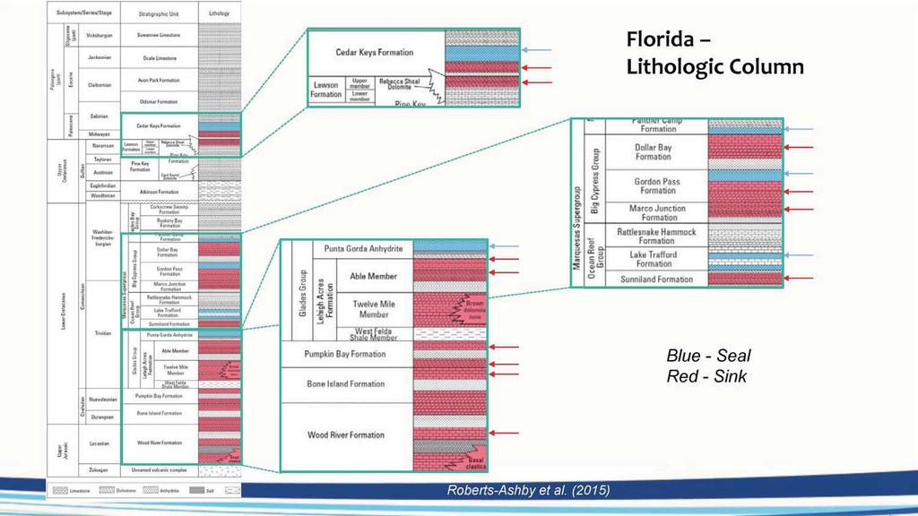
14 (Presenter s notes continued from previous slide) Paleozoic-Mesozoic basement rocks include large continental margin volcanic wedges. Triassic rift basins are developed locally, and a regionally extensive breakup unconformity is overlain the by Jurassic Louann Salt. Jurassic and Early Cretaceous strata above the salt contain a variety of extensional structures, including salt rollers, diapirs, and giant salt pillows. Upper Cretaceous strata are gently deformed and were deposited mainly on a stable continental shelf. Mesozoic strata include a complex array of carbonate and siliciclastic rock types. The Tampa Embayment and South Florida Basin constitute the West Florida Shelf, which has been a site of limited hydrocarbon exploration and thus sparse well control. The West Florida Shelf is very shallow and is dominated by carbonate strata of Mesozoic and Cenozoic age. Regionally, stratigraphic markers can be traced across large regions of the shelf. The west margin of the shelf, called the West Florida Escarpment, is very steep and forms a distinctive curvilinear feature bound by the Cretaceous reef trend. Although offshore petroleum production has yet to be proven in this area, the strata that form the shelf contain significant source rocks, reservoirs, and seals onshore in the Sunniland trend (Mitchell-Tapping, 1984) and have significant CO2 storage potential (Roberts-Ashby et al., in review). All told, for the approximately 400 wells within the study area, there are about 3400 available logs. Log coverage is fairly good, but not for all logs types. Sonic/velocity logs are scarcer.

15 Presenter s notes: Preliminary targets for CO2 sequestration have been identified (e.g., Hills and Pashin, 2010) in northern part of study area Miocene sands (both state and federal waters) Cretaceous strata (federal waters) Additional targets in Western FL escarpment There are challenges in the EGOM: (Presenter s notes continued on next slide)
16 (Presenter s notes continued from previous slide) Petroleum exploration, however, has proven technically challenging in the region, and the greatest success has been found in the ultra-deep (>20,000ft) natural gas reservoirs of the Mobile area. Although the proven petroleum reservoirs in the region are too deep to facilitate economically viable CO2- enhanced recovery operations, porous intervals have been identified in shallower carbonate and siliciclastic strata (Petty, 1997, 1999). Offshore infrastructure quite variable. Giant Norphlet platform contrasted with tiny Miocene platform, all in Alabama state waters in Mobile area. View shed issue major constraint on offshore development. Subsea operations could keep wells out of sight.

17 Presenter s notes: Seismic profile from Mariner Field, southern Mississippi, showing amplitude anomaly (bright spot) associated with gas accumulation. Miocene bright spot plays provide shallow opportunities. Amplitude anomalies associated with gas accumulations readily identified in seismic, but these are just tips of the iceberg. Water-filled sands don't image as bright spots. Preliminary analysis indicates that the bulk of the storage capacity in Miocene sandstone resides in saline formations below the commercial gas accumulations.
 Variable sand distribution, but major sequestration potential where the sands are stacked.")
18 Presenter s notes: Preliminary work: Preliminary work (Hills and Pashin, 2010): Figure: Net Miocene Sand, AL State waters. Sands shallower than 2480 were excluded (to reach CO2 super-critical/be below any potential USDW) Variable sand distribution, but major sequestration potential where the sands are stacked. Pore volume was calculated using a porosity of 25%. Using an efficiency factor of 10%, and a CO2 density of 0.7 g/cc Storage of 9.1 x 10^9 mt (Fed), 1.0 x10^9 mt (state) Capacity 3.4 x 10^7 (fed), 9.4 x 10^5 mt/mi2( state)

19 Presenter s notes: Diverse sandstone and carbonate facies in Cretaceous, including reef-rimmed continental margin. Cretaceous facies in the region are dominated by sliliciclastic coastal plain deposits that pass basinward into reef-rimmed carbonate platform deposits. Siliciclastic strata include formations that have been tested for CO2 storage potential onshore, whereas the storage potential of carbonate formations is less certain. Previous work on the Cretaceous strata has largely been on-shore. Preliminary offshore capacity estimates (Hills and Pashin, 2010): min volume >8.9 x 10^10 mt; min capacity of 3.3 x 10^6 mt/mi 2

20 Presenter s notes: Cretaceous Gulf Coast sands are trés bien. Lots of stuff like this in Cretaceous-Tertiary section in offshore EGOM. Onshore, much of the sequestration potential has been identified in the Upper and Lower Tuscaloosa Group. Upper right figure (Figure 3, Pashin et al., 2008): Cross-plot of porosity and permeability data from core analyses of sandstone from the Paluxy Formation through the Eutaw Formation in southwestern Alabama. Consistent mean porosity values above 23.3 % have been observed in all the analyzed stratigraphic units.
 Cretaceous sandstone targets would most likely be found in the Lower Cretaceous B and A and more commonly in the the Cotton Valley Group.")
21 Presenter s notes: Lithologic logs showing rock types and major mappable stratigraphic units in the DeSoto Canyon Salt Basin. (enlarged in next slide) Cretaceous sandstone targets would most likely be found in the Lower Cretaceous B and A and more commonly in the the Cotton Valley Group. Multiple seals are present above these strata (Ferry Lake Anhydrite, the Marine Tuscaloosa Shale) QTm Quaternary-Miocene TKpu Paleocene-Upper Cretaceous Kla Lower Cretaceous A Jhs Haynesville and Smackover Fms Jn Norphlet Fm Top Oligocene-Paleocene Klb Lower Cretaceous B KJcv Cotton Valley Group Js Smackover Fm Jl Louann Salt

22 Presenter s notes: Structural Style, Northeastern Salt Basin. Seismic profile showing structural style of the northeastern DeSoto Canyon Salt Basin. QTm Quaternary-Miocene TKu Paleocene-Upper Cretaceous Kla Lower Cretaceous A Jhs Haynesville and Smackover Formations Basement Paleozoic and Mesozoic basement Top Oligocene-Paleocene Klb Lower Cretaceous B KJcv Cotton Valley Group Jl Louann Salt
23

24 Presenter s notes: Bathymetric map of the West Florida Shelf (source: USGS). Note progressive steepening of the continental slope, culminating in the West Florida Escarpment. Broad, shallow, region near shore (NE of 80 m contour). Distally steepening outer shelf leading to West Florida Escarpment

25 Presenter s notes: Pre-stack, depth converted seismic profile showing geologic architecture along a transect from the West Florida Shelf to the continental rise (after Roberts and Erickson, 2009). Note major carbonate platform bounded by Cretaceous reef trend and overlain by prograded shelf. Structures southwest of platform include apparent Mesozoic mini basins below subhorizontal Cenozoic strata of the continental rise. Thick Jurassic/Cretaceous section in the deepwater outboard of the escarpment showing all the plays associated with an autochthonous salt basin. (Also evidence for an extension of the Norphlet SS along foot of escarpment)
26 Presenter s notes: High-quality public 2D seismic data available. Geophysical log coverage spotty above Jurassic.
THE NORPHLET SANDSTONE AND OTHER PETROLEUM PLAYS ALONG AND OUTBOARD OF THE FLORIDA ESCARPMENT, EASTERN GULF OF MEXICO
 THE NORPHLET SANDSTONE AND OTHER PETROLEUM PLAYS ALONG AND OUTBOARD OF THE FLORIDA ESCARPMENT, EASTERN GULF OF MEXICO Glyn Roberts 1, Joe Erickson 2 1 Consultant, Bedford, UK; 2 Spectrum, Houston, TX.
(Brown & Loucks, 2009)
") SECARB Phase 3, Task 15 Geological CO 2 Sequestration Capacity Estimate Offshore Northern Gulf of Mexico March 9, 2011 Prepared by David L. Carr Project Team: Cari Breton, GIS Analyst David L. Carr, Reservoir
SECARB Phase 3, Task 15 Geological CO 2 Sequestration Capacity Estimate Offshore Northern Gulf of Mexico March 9, 2011 Prepared by David L. Carr Project Team: Cari Breton, GIS Analyst David L. Carr, Reservoir
EGAS. Ministry of Petroleum
 EGAS Ministry of Petroleum EGAS Ministry of Petroleum About The Block Location: N. El Arish offshore block is located in the extreme eastern part of the Egypt s economic water border and bounded from the
Offshore Geosequestration Potential in the Gulf of Mexico. Carbon Sequestration Opportunities in the North Sea Conference March, 2010
 Offshore Geosequestration Potential in the Gulf of Mexico Presenter: Ramón Treviño Gulf Coast Carbon Center Bureau of Economic Geology University of Texas at Austin, Carbon Sequestration Opportunities
EGAS. Ministry of Petroleum
 EGAS Ministry of Petroleum EGAS Ministry of Petroleum About The Block Location: N. Thekah offshore block is located at about 56 km to the north of the Mediterranean shore line, 85 km to the north west
Aptian/Albian Reservoir Development in the Jeanne d Arc Basin, Offshore Eastern Canada
 Aptian/Albian Reservoir Development in the Jeanne d Arc Basin, Offshore Eastern Canada Jonathan Marshall, Statoil Canada Ltd. Calgary, Alberta, Canada. jomars@statoil.com Introduction: The Jeanne d Arc
Main Challenges and Uncertainties for Oil Production from Turbidite Reservoirs in Deep Water Campos Basin, Brazil*
 Main Challenges and Uncertainties for Oil Production from Turbidite Reservoirs in Deep Water Campos Basin, Brazil* Carlos H. Bruhn 1, Antonio Pinto 1, and Paulo R. Johann 1 Search and Discovery Article
Structural Styles and Geotectonic Elements in Northwestern Mississippi: Interpreted from Gravity, Magnetic, and Proprietary 2D Seismic Data
 Structural Styles and Geotectonic Elements in Northwestern Mississippi: Interpreted from Gravity, Magnetic, and Proprietary 2D Seismic Data Nick Loundagin 1 and Gary L. Kinsland 2 1 6573 W. Euclid Pl.,
Gulf of México Mapping NATCARB Atlas
 Gulf of México Mapping NATCARB Atlas Presenter: Ramón Treviño Gulf Coast Carbon Center University of Texas at Austin, Bureau of Economic Geology NACAP Cuernavaca, Morelos, México March 9, 2010 Acknowledgements
ANNUAL REPORT BASIN ANALYSIS OF THE MISSISSIPPI INTERIOR SALT BASIN AND PETROLEUM SYSTEM MODELING OF THE JURASSIC SMACKOVER FORMATION,
 ANNUAL REPORT BASIN ANALYSIS OF THE MISSISSIPPI INTERIOR SALT BASIN AND PETROLEUM SYSTEM MODELING OF THE JURASSIC SMACKOVER FORMATION, EASTERN GULF COASTAL PLAIN Submitted to U.S. Department of Energy
Petroleum geology framework, West Coast offshore region
 Petroleum geology framework, West Coast offshore region James W. Haggart* Geological Survey of Canada, Vancouver, BC jhaggart@nrcan.gc.ca James R. Dietrich Geological Survey of Canada, Calgary, AB and
MUHAMMAD S TAMANNAI, DOUGLAS WINSTONE, IAN DEIGHTON & PETER CONN, TGS Nopec Geological Products and Services, London, United Kingdom
 Geological and Geophysical Evaluation of Offshore Morondava Frontier Basin based on Satellite Gravity, Well and regional 2D Seismic Data Interpretation MUHAMMAD S TAMANNAI, DOUGLAS WINSTONE, IAN DEIGHTON
35th Annual GCSSEPM Foundation Bob F Perkins Research Conference 2016
 35th Annual GCSSEPM Foundation Bob F Perkins Research Conference 2016 Mesozoic of the Gulf Rim and Beyond: New Progress in Science and Exploration of the Gulf of Mexico Basin Houston, Texas, USA 8 9 December
Midwest Regional Carbon Sequestration Partnership (MRCSP) Press Briefing. February 21, 2008
 Press Briefing. February 21, 2008") Midwest Regional Carbon Sequestration Partnership (MRCSP) Michigan Basin Test Site Press Briefing Introduction and Overview: Abed Houssari, DTE Energy DOE s Sequestration Program: Lynn Brickett, US DOE/NETL
Midwest Regional Carbon Sequestration Partnership (MRCSP) Michigan Basin Test Site Press Briefing Introduction and Overview: Abed Houssari, DTE Energy DOE s Sequestration Program: Lynn Brickett, US DOE/NETL
APPENDIX C GEOLOGICAL CHANCE OF SUCCESS RYDER SCOTT COMPANY PETROLEUM CONSULTANTS
 APPENDIX C GEOLOGICAL CHANCE OF SUCCESS Page 2 The Geological Chance of Success is intended to evaluate the probability that a functioning petroleum system is in place for each prospective reservoir. The
Global Opportunities for Offshore CCS : Assessing Offshore Storage on Continental Shelves
 Global Opportunities for Offshore CCS : Assessing Offshore Storage on Continental Shelves International Workshop on Offshore Geological CO 2 Storage Austin, Texas April 19 20, 2016 Dr. Tip Meckel, Research
A comparison of structural styles and prospectivity along the Atlantic margin from Senegal to Benin. Peter Conn*, Ian Deighton* & Dario Chisari*
 A comparison of structural styles and prospectivity along the Atlantic margin from Senegal to Benin Overview Peter Conn*, Ian Deighton* & Dario Chisari* * TGS, Millbank House, Surbiton, UK, KT6 6AP The
We A Multi-Measurement Integration Case Study from West Loppa Area in the Barents Sea
 We-16-12 A Multi-Measurement ntegration Case Study from West Loppa Area in the Barents Sea. Guerra* (WesternGeco), F. Ceci (WesternGeco), A. Lovatini (WesternGeco), F. Miotti (WesternGeco), G. Milne (WesternGeco),
Salt Geology and New Plays in Deep-Water Gulf of Mexico* By Abu Chowdhury 1 and Laura Borton 1
 Salt Geology and New Plays in Deep-Water Gulf of Mexico* By Abu Chowdhury 1 and Laura Borton 1 Search and Discovery Article #10131 (2007) Posted August 25, 2007 *Adapted from extended abstract prepared
Outline 16: The Mesozoic World: Formation of Oil Deposits (with a side trip to the Devonian Marcellus Shale)
") Outline 16: The Mesozoic World: Formation of Oil Deposits (with a side trip to the Devonian Marcellus Shale) The first commercial oil well was drilled by Colonel Edwin Drake in Titusville, Pennsylvania,
Outline 16: The Mesozoic World: Formation of Oil Deposits (with a side trip to the Devonian Marcellus Shale) The first commercial oil well was drilled by Colonel Edwin Drake in Titusville, Pennsylvania,
Subsurface Geology and Resource Exploration
 LAB 11. Subsurface Geology and Resource Exploration Locating earth resources such as aluminum, copper, gold and gemstones has been an important job for geologists for a long time. This lab deals with the
ANGOLA OFFSHORE LICENSING 2007 BLOCK 46
 AGOLA OFFHOR LICIG 2007 BLOCK 46 DATA BA AVAILABILITY Figure 1 shows the seismic data available on Block 46. Fig. 1 Commercial 2D surveys: esterngeco: 794 km. GX Technology: 116 km. Commercial 3D surveys:
Characterizing Seal Bypass Systems at the Rock Springs Uplift, Southwest Wyoming, Using Seismic Attribute Analysis*
 Characterizing Seal Bypass Systems at the Rock Springs Uplift, Southwest Wyoming, Using Seismic Attribute Analysis* Yuri Ganshin 1 and Fred McLaughlin 1 Search and Discovery Article #80483 (2015)** Posted
Meandering Miocene Deep Sea Channel Systems Offshore Congo, West Africa
 Meandering Miocene Deep Sea Channel Systems Offshore Congo, West Africa S. Baer* (PGS), J. E. Comstock (PGS), K. Vrålstad (PGS), R. Borsato (PGS), M. Martin (PGS), J.P. Saba (SNPC), B. Débi-Obambé (SNPC)
Orphan Basin, Offshore Newfoundland: New seismic data and hydrocarbon plays for a dormant Frontier Basin
 Orphan Basin, Offshore Newfoundland: New seismic data and hydrocarbon plays for a dormant Frontier Basin Jerry Smee* G&G Exploration Consulting, 301 400-3rd Avenue SW, Calgary, AB, T2P 4H2 Sam Nader, Paul
Overview of Selected Shale Plays in New Mexico*
 Overview of Selected Shale Plays in New Mexico* Ron Broadhead 1 Search and Discovery Article #10627 (2014)** Posted August 18, 2014 *Adapted from presentation at RMAG luncheon meeting, Denver, Colorado,
The Late Tertiary Deep-Water Siliciclastic System of the Levant Margin - An Emerging Play Offshore Israel*
 The Late Tertiary Deep-Water Siliciclastic System of the Levant Margin - An Emerging Play Offshore Israel* Michael A. Gardosh 1, Yehezkel Druckman 2 and Binyamin Buchbinder 2 Search and Discovery Article
Thesis Proposal: Salt Reconstruction and Study of Depositional History, Upper Jurassic, East Texas Basin
 Thesis Proposal: Salt Reconstruction and Study of Depositional History, Upper Jurassic, East Texas Basin By: Krista Mondelli Advisor: Dr. Chris Liner April, 2009 2 Introduction The East Texas Basin covers
Structural Geology of the Mountains
 Structural Geology of the Mountains Clinton R. Tippett Shell Canada Limited, Calgary, Alberta clinton.tippett@shell.ca INTRODUCTION The Southern Rocky Mountains of Canada (Figure 1) are made up of several
Energy From the Earth Geologic Carbon Storage: Feasibility, Technology, and Challenges
 Energy From the Earth Geologic Carbon Storage: Feasibility, Technology, and Challenges Geological Requirements and Potential for Carbon Dioxide Storage in the United States Peter D. Warwick U.S. Geological
Bulletin of Earth Sciences of Thailand. Evaluation of the Petroleum Systems in the Lanta-Similan Area, Northern Pattani Basin, Gulf of Thailand
 Evaluation of the Petroleum Systems in the Lanta-Similan Area, Northern Pattani Basin, Gulf of Thailand Sirajum Munira Petroleum Geoscience Program, Department of Geology, Faculty of Science, Chulalongkorn
Source Sink Pipeline
 An Overview of Carbon Storage presented by Robert J. Finley Advanced Energy Technology Initiative Illinois State Geological Survey University of Illinois USA IEA Summer School Longyearbyen, Norway August,
Perspectives from Offshore Argentina & Uruguay
 Perspectives from Offshore Argentina & Uruguay A Prospectivity Overview Hannah Kearns October 2018 Introduction Argentina Offshore License Round 1 14 blocks Argentina North, 24 Austral-Malvinas Offshore
The United States & Canada. A Regional Study of Anglo America
 A Regional Study of Anglo America Landform Regions of the United States & Canada world leaders in agricultural and industrial production because of... VAST LANDS stretch from the Atlantic Ocean on the
Kilometre-Scale Uplift of the Early Cretaceous Rift Section, Camamu Basin, Offshore North-East Brazil*
 Kilometre-Scale Uplift of the Early Cretaceous Rift Section, Camamu Basin, Offshore North-East Brazil* Iain Scotchman 1 and Dario Chiossi 2 Search and Discovery Article #50183 (2009) Posted May 20, 2009
An Assessment of Geological Carbon Sequestration in the Illinois Basin: The Illinois Basin-Decatur Site
 An Assessment of Geological Carbon Sequestration in the Illinois Basin: The Illinois Basin-Decatur Site presented by Robert J. Finley and the MGSC Project Team April 15, 2009 Illinois Sustainable Technology
SEDIMENTARY BASINS BASIN TYPES ACCORDING TO TECTONIC. by Prof. Dr. Abbas Mansour
 SEDIMENTARY BASINS BASIN TYPES ACCORDING TO TECTONIC by Prof. Dr. Abbas Mansour B. Convergent plate margins 10. STABLE CONTINENTAL INTERIOR BASIN E.g. Lake Eyre Basin Intracratonic (= within stable continental
Figure 1 Extensional and Transform Fault Interaction, Influence on the Upper Cretaceous Hydrocarbon System, Equatorial Margin, West Africa.
 Figure 1 Extensional and Transform Fault Interaction, Influence on the Upper Cretaceous Hydrocarbon System, Equatorial Margin, West Africa. Presented to the 10th PESGB/HGS Conference on Africa E + P September
Abstract. Introduction. Regional Setting. GCSSEPM to be published December 2003
 Shelf Margin Deltas and Associated Deepwater Deposits: Implications on Reservoir Distribution and Hydrocarbon Entrapment, Block VI-1, Ulleung Basin, East Sea, South Korea Sneider, John S. Sneider Exploration,
Distribution of Overpressure and its Prediction in Saurashtra Dahanu Block, Western Offshore Basin, India*
 Distribution of Overpressure and its Prediction in Saurashtra Dahanu Block, Western Offshore Basin, India* Kanak R. Nambiar 1, B.K. Singh 2, R.N. Goswami 2, and K.R.K. Singh 2 Search and Discovery Article
Figure 1: Location and bathymetry of the study area. Gulf of Guinea. Cameroon. Congo. Gabon. PGS/DGH Gabon MegaSurvey Coverage (35000Km 2 ) Eq.
 Eq.") Deepwater hydrocarbon prospectivity analysis of offshore North and South Gabon Muhammad S Tamannai (*), Thomas Hansen (1), Ron Borsato (1), Jennifer Greenhalgh (1) Martial-Rufin Moussavou (2) & Landry
Deepwater hydrocarbon prospectivity analysis of offshore North and South Gabon Muhammad S Tamannai (*), Thomas Hansen (1), Ron Borsato (1), Jennifer Greenhalgh (1) Martial-Rufin Moussavou (2) & Landry
Integrated well log and 3-D seismic data interpretation for the Kakinada area of KG PG offshore basin
 IOSR Journal of Applied Geology and Geophysics (IOSR-JAGG) e-issn: 2321 0990, p-issn: 2321 0982.Volume 5, Issue 4 Ver. II (Jul. Aug. 2017), PP 01-05 www.iosrjournals.org Integrated well log and 3-D seismic
Hydrocarbon Potential of the Marginal Fields in Niger Delta Oza Field, a case study*
 Hydrocarbon Potential of the Marginal Fields in Niger Delta Oza Field, a case study* J.N. Sahu 1, C.H.V. Satya Sai 1, V. Chintamani 1 and C. Vishnu Vardhan 1 Search and Discovery Article #20182 (2012)*
Geography 3202 Unit 4 S.C.O. 4.3 & 4.5. Primary Resource Activities Offshore Oil And Gas
 Geography 3202 Unit 4 S.C.O. 4.3 & 4.5 Primary Resource Activities Offshore Oil And Gas Factors Affecting The Decision To Recover Offshore Oil And Gas (4.3.1) Physical Factors 1. Ocean Related Factors
1. Canadian Energy Use
 1 Unit 3 Energy 2 1. Canadian Energy Use Why are Canadians the sixth highest energy users in the world? Our major industries are energy intensive, overall industry consumes 31% of all energy in Canada.
Geologic Storage (Almacenamiento Geológico) Carbon Dioxide (CO 2 )
 Carbon Dioxide (CO 2 )") Geologic Storage (Almacenamiento Geológico) Carbon Dioxide (CO 2 ) GCCC Digital Publication Series #08-06 Ramón H. Treviño Keywords: Field study-cranfield-ms, Monitoring-design, Overview Cited as: Treviño,
Geologic Storage (Almacenamiento Geológico) Carbon Dioxide (CO 2 ) GCCC Digital Publication Series #08-06 Ramón H. Treviño Keywords: Field study-cranfield-ms, Monitoring-design, Overview Cited as: Treviño,
Deepwater Subsalt-Suprasalt Middle to Lower Slope Sands & Reservoirs of the US Gulf of Mexico: The Evolution Of An Exciting Giant Field Concept
 Deepwater Subsalt-Suprasalt Middle to Lower Slope Sands & Reservoirs of the US Gulf of Mexico: The Evolution Of An Exciting Giant Field Concept Dwight Clint Moore & Bill Lefler with Rich Heaney, Mike Neese,
Vail et al., 1977b. AAPG 1977 reprinted with permission of the AAPG whose permission is required for further use.
 Well 5 Well 4 Well 3 Well 2 Well 1 Vail et al., 1977b AAPG 1977 reprinted with permission of the AAPG whose permission is required for further use. Well 5 Well 4 Well 3 Well 2 Well 1 Vail et al., 1977b
Current challenges at CO 2 Sites
 Current challenges at CO 2 Sites Ola Eiken et al., Statoil R&D Force seminar on injection safety 4 th December 2013 Offshore Sleipner Onshore In Salah Sub-sea Snøhvit 1 - Classification: External 2010-09-23
Search and Discovery Article # (2015) Posted April 20, 2015
 Posted April 20, 2015") Considering the Vertical Variation in Rock Mechanical Properties of a Lithologic Zone Using Laboratory Derived Data Is it Time for Geomechanical Stratigraphy?* Douglas E. Wyatt 1, Jesse Hampton 1, Dandan
Considering the Vertical Variation in Rock Mechanical Properties of a Lithologic Zone Using Laboratory Derived Data Is it Time for Geomechanical Stratigraphy?* Douglas E. Wyatt 1, Jesse Hampton 1, Dandan
Sedimentary Cycle Best Practice: Potential Eo-Oligocene Sediments in Western Indonesia*
 Sedimentary Cycle Best Practice: Potential Eo-Oligocene Sediments in Western Indonesia* Mellinda Arisandy 1 and I Wayan Darma 1 Search and Discovery Article #11008 (2017)** Posted November 6, 2017 *Adapted
Play fairway mapping in the Northeast Atlantic Margin Comparison between mature and immature basins. David Mudge, Joanne Cranswick
 Play fairway mapping in the Northeast Atlantic Margin Comparison between mature and immature basins David Mudge, Joanne Cranswick Contents Ternan North Sea Play fairway mapping Tertiary case study Northeast
Petroleum Prospectivity in the Namibe and Southern Benguela Basins, Offshore Angola
 Petroleum Prospectivity in the Namibe and Southern Benguela Basins, Offshore Angola C. Koch* (PGS), F. Pepe (PGS), R. Vasconcelos (PGS), F. Mathew (PGS), R. Borsato (PGS) & M.P.C. de Sá (Sonangol) SUMMARY
Geologic influence on variations in oil and gas production from the Cardium Formation, Ferrier Oilfield, west-central Alberta, Canada
 Geologic influence on variations in oil and gas production from the Cardium Formation, Ferrier Oilfield, west-central Alberta, Canada Marco Venieri and Per Kent Pedersen Department of Geoscience, University
The Governor s Conference on Energy
 The Governor s Conference on Energy Track Reducing Our Dependence on Foreign Oil Session The Technology of Exploration and Development US Atlantic Margin Geotechnical Evaluation Dwight Clint Moore Vice-President
West Coast Research. WESTCARB Technical Director California Energy Commission
 Field Experience from West Coast Research Larry Myer WESTCARB Technical Director California Energy Commission lrmyer@lbl.gov Carbon Capture & Sequestration Public Workshop Bakersfield, CA September 25,
Controls on clastic systems in the Angoche basin, Mozambique: tectonics, contourites and petroleum systems
 P2-2-13 Controls on clastic systems in the Angoche basin, Mozambique: tectonics, contourites and petroleum systems Eva Hollebeek, Olivia Osicki, Duplo Kornpihl Schlumberger, London, UK Introduction Offshore
The Mesozoic. Wednesday, November 30, 11
 The Mesozoic Periods of the Mesozoic Triassic- First period of the Mesozoic era Jurassic Cretaceous- Last period of the Mesozoic era Breakup of Pangaea Stage one (Triassic) Rifting and volcanism, normal
Blocks 31, 32, 33, 34, 35 & 36/03 Southeast Offshore Vietnam
 Blocks 31, 32, 33, 34, 35 & 36/03 Southeast Offshore Vietnam Block 31 32 33 34 35 36/03 Area (km 2) 5,036 4,440 4,630 4,700 4,630 2,950 Sea level (m) 20 20-30 30-40 50 50 50 Seismic 2D (km) 1,294 685 431
Gas hydrate-related sedimentary pore pressure changes offshore Angola
 Gas hydrate-related sedimentary pore pressure changes offshore Angola Christian Berndt and Bedanta Goswami 1 National Oceanography Centre, Southampton, U.K. cbe@noc.soton.ac.uk, bedantag@gmail.com ABSTRACT
Osareni C. Ogiesoba and Angela K. Eluwa. Bureau of Economic Geology, University of Texas at Austin, Burnet Rd., Austin Texas 78759
 Structural Styles of Eocene Jackson and Oligocene Vicksburg Formations within the Rio Grande and Houston Embayments near the San Marcos Arch, Refugio and Calhoun Counties, South Texas Gulf Coast Osareni
PETROLEUM GEOSCIENCES GEOLOGY OR GEOPHYSICS MAJOR
 PETROLEUM GEOSCIENCES GEOLOGY OR GEOPHYSICS MAJOR APPLIED GRADUATE STUDIES Geology Geophysics GEO1 Introduction to the petroleum geosciences GEO2 Seismic methods GEO3 Multi-scale geological analysis GEO4
BACK TO BASICS WHY THE TORRES BASIN COULD BE A COMPANY MAKER Papua New Guinea :PPL326 A Frontier Basin
 BACK TO BASICS WHY THE TORRES BASIN COULD BE A COMPANY MAKER Papua New Guinea :PPL326 A Frontier Basin 1 Tertiary Carbonate/Clastic Prospects and Leads PNG_LNG Facility PPL326 has a large number of over
Controls on facies distributions in the Charlie Lake Formation, Peace River Arch, Alberta
 Controls on facies distributions in the Charlie Lake Formation, Peace River Arch, Alberta E.L. Percy 12, C. Frostad 2, A. Juska 2, C. Schmidt 2, C. Sitzler 2, and J.P. Zonneveld 3 University of Calgary,
Regional Paleogeography and Implications for Petroleum Prospectivity, Taranaki Basin, New Zealand*
 Regional Paleogeography and Implications for Petroleum Prospectivity, Taranaki Basin, New Zealand* Dominic P. Strogen 1, Kyle J. Bland 1, Jan R. Baur 1,2, and Peter R. King 1 Search and Discovery Article
Geologic CO 2 Storage Options for California
 Geologic CO 2 Storage Options for California Larry Myer WESTCARB Technical Director California Energy Commission lrmyer@lbl.gov Carbon Capture & Sequestration Public Workshops February 13 14, 2008 Outline
What is the scope for carbon capture and storage in Northern Ireland. Michelle Bentham
 What is the scope for carbon capture and storage in Northern Ireland Michelle Bentham Kingsley Dunham Centre Keyworth Nottingham NG12 5GG Tel 0115 936 3100 What is Carbon Capture and Storage? Capture of
Sequence Stratigraphy of the Upper Cretaceous Niobrara Formation, A Bench, Wattenberg Field, Denver Julesburg Basin, Colorado*
 Sequence Stratigraphy of the Upper Cretaceous Niobrara Formation, A Bench, Wattenberg Field, Denver Julesburg Basin, Colorado* Lisa E. Remington LaChance 1 and Mark C. Robinson 1 Search and Discovery Article
The importance of stratigraphic plays in the undiscovered resources of the UKCS
 The importance of stratigraphic plays in the undiscovered resources of the UKCS Sue Stoker 1, Joy Gray 2, Peter Haile 2, Ian Andrews 1 & Don Cameron 1 1 British Geological Survey 2 Department of Trade
Case Study of the Structural and Depositional-Evolution Interpretation from Seismic Data*
 Case Study of the Structural and Depositional-Evolution Interpretation from Seismic Data* Yun Ling 1, Xiangyu Guo 1, Jixiang Lin 1, and Desheng Sun 1 Search and Discovery Article #20143 (2012) Posted April
Biostratigraphic and Lithostratigraphic Correlation of Sedimentary Strata in the Atlantic Coastal Plain
 Biostratigraphic and Lithostratigraphic Correlation of Sedimentary Strata in the Atlantic Coastal Plain Introduction to the Atlantic Coastal Plain (Please read this page prior to doing the lab) The Atlantic
Clint Moore with Bill Lefler, Tom Uphoff, Rich Heaney, & Mike Neese
 The Evolution of a Proven Giant Oil & Gas Play in Subsalt Miocene Lower Slope Sands-Reservoirs of the Federal Offshore OCS Shelf, US Gulf of Mexico Clint Moore with Bill Lefler, Tom Uphoff, Rich Heaney,
Advanced Exploration Technology & Concepts: Key to Future Gulf of Mexico Deep Shelf Oil & Gas
 Advanced Exploration Technology & Concepts: Key to Future Gulf of Mexico Deep Shelf Oil & Gas Dwight Clint Moore & Michael Neese with Rich Heaney, Bill Lefler, & Tom Uphoff GCAGS 2014 Lafayette, LA October
B.C. s Offshore Oil and Gas: a Guide to the Geology and Resources.
 B.C. s Offshore Oil and Gas: a Guide to the Geology and Resources. Introduction Beneath the offshore regions of British Columbia are four moderately large, geologically young sedimentary basins (Figure
Block 43B - Onshore Oman
 Block 43B - Onshore Oman SUMMARY Block 43B is an 11,967 km 2 area located along the coastal area of Oman north of the Hajar Mountains. This is an unexplored region, both geographically and stratigraphically.
The map The ma (Somaliland ( Somaliland Somalia) SOMALIA SOMALILAND
 SOMALIA SOMALILAND") SOMALILAND COUNTRY BACKGROUND & HYDROCARBON POTENTIAL MINISTRY OF WATER & MINERAL RESOURCES PRESENTATION OUTLINE Introduction Petroleum Geology Petroleum Regulations & PSC Model Re-sizing of Blocks Current
SOMALILAND COUNTRY BACKGROUND & HYDROCARBON POTENTIAL MINISTRY OF WATER & MINERAL RESOURCES PRESENTATION OUTLINE Introduction Petroleum Geology Petroleum Regulations & PSC Model Re-sizing of Blocks Current
WESTCARB Phase I Results Review
 WESTCARB Phase I Results Review Arizona Geologic Characterization Errol Montgomery Principal Errol L. Montgomery & Associates (520) 881-4912 emontgomery@elmontgomery.com November 9, 2005 Site Characterization
EGAS. Ministry of Petroleum and Mineral Resources EGAS
 EGAS 5 8 7 6 2 1 3 Block Summary Location: North Ras El Esh Offshore Block is located in the shallow waters of the Mediterranean Sea, at the outlet of Damietta Branch of the River Nile. The southern boundary
Search and Discovery Article #50379 (2011) Posted February 25, Abstract
 Posted February 25, Abstract") Click to view oral presentation, with abstract and references. Understanding the Regional Haynesville and Bossier Shale Depositional Systems in East Texas and Northern Louisiana: An Integrated Structural/Stratigraphic
Click to view oral presentation, with abstract and references. Understanding the Regional Haynesville and Bossier Shale Depositional Systems in East Texas and Northern Louisiana: An Integrated Structural/Stratigraphic
Reconstruction of Paleogeographic Setup of Tura Formation in Rudrasagar-Disangmukh-Panidihing Area of Upper Assam Shelf using 3-D Seismic techniques
 5th Conference & Exposition on Petroleum Geophysics, Hyderabad-2004, India PP 792-796 in Rudrasagar-Disangmukh-Panidihing Area of Upper Assam Shelf using 3-D Seismic techniques S.M.Ismail 1, R.N.Dwivedi
Exploration, Drilling & Production
 Nontechnical Guide to PETMOLEUM Geology, Exploration, Drilling & Production Third Edition Norman J. Hyne, Ph.D. Contents Preface *i Introduction 1 The Nature of Gas and Oil 1 Petroleum 1 The Chemistry
Luderitz Basin, Offshore Namibia: Farm-out Opportunity. APPEX, London, March 2015 Graham Pritchard, Serica Energy plc
 Luderitz Basin, Offshore Namibia: Farm-out Opportunity APPEX, London, March 2015 Graham Pritchard, Serica Energy plc Serica Luderitz Basin Namibia Introduction Serica (85%, operator) 17,384 km 2 acreage
Interaction between Faults and Igneous Intrusions in Sedimentary Basins: Insights from 3D Seismic Reflection Data*
 Interaction between Faults and Igneous Intrusions in Sedimentary Basins: Insights from 3D Seismic Reflection Data* Craig Magee¹, Christopher A. Jackson¹, and Nick Schofield² Search and Discovery Article
ONSHORE / OFFSHORE & NEW SHALE POTENTIAL OF MOROCCO
 Kingdom of Morocco ONSHORE / OFFSHORE & NEW SHALE POTENTIAL OF MOROCCO Mr M. NAHIM Mrs N. ESSALLOUMI Key aspects of Morocco Political and economic stability; Economic policy of integration at regional
Ministry of Oil and Minerals Petroleum Exploration & Production Authority BLOCK 85 (Al Uqlah North)
") Ministry of Oil and Minerals Petroleum Exploration & Production Authority BLOCK 85 (Al Uqlah North) The Al Uqlah North Block (85) occupies an area of 597 km 2 in the Sabatayn Basin in the province of Shabwah
Ministry of Oil and Minerals Petroleum Exploration & Production Authority BLOCK 85 (Al Uqlah North) The Al Uqlah North Block (85) occupies an area of 597 km 2 in the Sabatayn Basin in the province of Shabwah
WP2 country review Lithuania
 Saulius Sliaupa Rasa Sliaupiene institute of Geology and Geography WP2 country review Lithuania CO 2 emission in Lithuania (2005) 94 sources listed in the CO2 trading system of Lithuania in 2005 CO 2 emissions
RELINQUISHMENT REPORT FOR LICENCE P.1663, BLOCK 29/4b and 29/5e
 RELINQUISHMENT REPORT FOR LICENCE P.1663, BLOCK 29/4b and 29/5e Licence: P.1663 Blocks: 29/4b & 29/5e 25th Round Traditional Licence Operator: Ithaca Energy UK(Ltd) 100% Work Programme Summary The agreed
Prospective Resources as of January 1, 2008
 Prospective Resources as of January 1, 2008 3 Mexico s prospective resources and their distribution in the most important producing basins are listed in this chapter. Pemex Exploración y Producción has
The Capitan Aquifer - Ellenburger Production Wells Geothermal Engine Source?
 GEOTHERMAL ENERGY UTILIZATION ASSOCIATED WITH OIL & GAS DEVELOPMENT June 17-18, 2008 Southern Methodist University Dallas, Texas The Capitan Aquifer - Ellenburger Production Wells Geothermal Engine Source?
SAND DISTRIBUTION AND RESERVOIR CHARACTERISTICS NORTH JAMJUREE FIELD, PATTANI BASIN, GULF OF THAILAND
 SAND DISTRIBUTION AND RESERVOIR CHARACTERISTICS NORTH JAMJUREE FIELD, PATTANI BASIN, GULF OF THAILAND Benjawan KIinkaew Petroleum Geoscience Program, Department of Geology, Faculty of Science, Chulalongkorn
MAPPING GEOLOGICAL STORAGE PROSPECTIVITY OF CO 2 FOR THE WORLD S SEDIMENTARY BASINS AND REGIONAL SOURCE TO SINK MATCHING
 MAPPING GEOLOGICAL STORAGE PROSPECTIVITY OF CO 2 FOR THE WORLD S SEDIMENTARY BASINS AND REGIONAL SOURCE TO SINK MATCHING John Bradshaw 1*, Tess Dance 1 1 Greenhouse Gas Technologies Cooperative Research
The Gulf of Mexico - From Various Vantage Points John E. Bain, Kenton J. Hamilton
 The Gulf of Mexico - From Various Vantage Points John E. Bain, Kenton J. Hamilton Oftentimes in exploration geophysics we tend to focus on specific near-term exploration prospects, as dictated by the current
US East Coast OCS: Past, Present, and Future Hydrocarbon Potential
 US East Coast OCS: Past, Present, and Future Hydrocarbon Potential Dr. Robert Erlich Washington, D.C. 15 April 2015 For Additional Background Google: Erlich AAPG Explorer May 2014 First, Two Brief Definitions..
UNIS CO 2 Lab of Arctic Norway - Coal power with CO 2 storage? - What about the natural gas?
 Fremtidens energiforsyning i Longyearbyen 12-13 June 2017 UNIS CO 2 Lab of Arctic Norway - Coal power with CO 2 storage? - What about the natural gas? Kim Senger (Associate Professor, UNIS) Snorre Olaussen
RELINQUISHMENT REPORT. License P1546 Block April 2009
 RELINQUISHMENT REPORT License P1546 Block 110-01 14 April 2009 Sherritt International Oil and Gas Limited 2000, 425-1 st street S.W., Calgary, Alberta Canada T2P 3L8 Telephone (403) 260-2900 Fax (403)
BALOCHISTAN FOLDBELT BASIN
 INTRODUCTION BALOCHISTAN FOLDBELT BASIN The Kharan-3 block is located in the Kharan Trough of Balochistan Basin. GEOLOGICAL SETTING The Balochistan Province is an Upper Cretaceous to Recent structurally
Finding Oil by Utilizing Play Analysis
 Finding Oil by Utilizing Play Analysis Gulf of Mexico Outer Continental Shelf An Overview of the Plio-Pleistocene and Miocene Shelf Trends Chris Williams, PG. Geoscientist Gulf of Mexico Outer Continental
Quiz 12 Bonus 2 (9:30-9:35 AM)
") Quiz 12 Bonus 2 (9:30-9:35 AM) UNIVERSITY OF SOUTH ALABAMA GY 112: Earth History Lectures 32 and 33: Mesozoic Sedimentation Instructor: Dr. Douglas W. Haywick Last Time Mesozoic Tectonics A) The Triassic
Quiz 12 Bonus 2 (9:30-9:35 AM) UNIVERSITY OF SOUTH ALABAMA GY 112: Earth History Lectures 32 and 33: Mesozoic Sedimentation Instructor: Dr. Douglas W. Haywick Last Time Mesozoic Tectonics A) The Triassic
P1645 Fig 1: Licence P1645 Introduction
 Licence Number: P.1645 commenced 12 th November 2008 Licence Round: 25 th Licence Type: Traditional Block Number: 9/8b Operator: EnQuest (60%) Partners: Norwegian Energy Company (Noreco) UK Ltd 40% Work
Geological CO 2 Storage Feasibility Study: Saline Aquifers and Depleted Oil Fields, Ordos Basin, Shaanxi Province
 U.S. - CHINA CLEAN ENERGY RESEARCH CENTER 中国清洁能源研究中心 Northwest University Geological CO 2 Storage Feasibility Study: Saline Aquifers and Depleted Oil Fields, Ordos Basin, Shaanxi Province 1 Ronald Surdam,