Drilling 2.5 km in the Swedish Caledonides: The COSC project
|
|
|
- Jane Fisher
- 5 years ago
- Views:
Transcription
1 Drilling 2.5 km in the Swedish Caledonides: The COSC project Christopher Juhlin Uppsala University, Sweden David Gee, Henning Lorenz (Uppsala University, Sweden) Christophe Pascal (Ruhr University, Germany) Chin-Fu Tsang (Lawrence Berkeley Labs, USA) Karsten Pedersen (Chalmers, Sweden) Randy Parrish (BGS, UK) Leif Bjelm, Jan-Erik Rosberg (Lund University, Sweden) 1
 Lower Sole thrust Autochthon Collisional Orogeny")
2 Where are we and what are we looking for? Allochthon Upper Middle (hot) Lower Sole thrust Autochthon Collisional Orogeny in the Scandinavian Caledonides (COSC) 2
 3")
3 The Caledonian front north of the COSC area Clear detachment close to basement Duplication and triplication of units above Transport of allochthons of at least 70 km along a black shale (Gee et al., 1978; SGU 742) 3
4 Why drill in the Caledonides? Tectonic evolution Channel flow Basement involved thrusting Comparison with the Himalayas Present day and past deep fluid circulation patterns Current heat flow and climate modeling Deep biosphere Calibration of high quality surface geophysics 4
 8 potential drill sites in Sweden Swedish Research Council (VR) funded drill rig for depths of 2.")
5 Swedish Deep Drilling Program ( 8 potential drill sites in Sweden Swedish Research Council (VR) funded drill rig for depths of 2.5 km Will become the Swedish Scientific Drilling Program ( 5
6 8 drilling proposals Collisional Orogeny in the Scandinavian Caledonides (COSC) Postglacial Fault Drilling Project (PFDP or DAFNE). Concentric Impact Structures in the Palaeozoic the Lockne and Siljan craters (CISP) Palaeoproterozoic mineralized volcanic arc systems: the Skellefte district (PaMVAS) The Alnö complex: A messenger from the Earth s mantle Baltic Glacial History (spin-off of IODP expedition#347) The Dellen Impact Crater: Integrated physical, hydrological, chemical, biological and mechanical characterization of deep crystalline rocks A geoscientifc deep rock laboratory (DRL) Svecofennian accretion, an example of the early Structural Evolution in a Large Hot Orogen (SELHO)

7 7

8 8
9 COSC funding Drilling costs 1 MUSD from ICDP (International Continental Scientific Drilling Program) 4.3 MSEK from the Swedish Research Council Scientific studies Various national funding agencies 9

10 COSC Project focus: better understanding of orogenic processes, both in the past and in today s active mountain belts (Gee et al., 2010: GFF) 10
11 The Swedish Deep Drilling Program for science and society... c Ma Laurentia Baltica
12 The Swedish Deep Drilling Program for science and society... c. 480 Ma aurentia Baltica
13 The Swedish Deep Drilling Program for science and society... c. 450 Ma Laurentia Baltica

14 The Swedish Deep Drilling Program for science and society... c. 440 Ma Laurentia Baltica

15 The Swedish Deep Drilling Program for science and society... Laurussia
16 The Swedish Deep Drilling Program for science and society...

17 Comparison to the Himalayas India-Asia collision zone - high spatial image from NASA Earth-observing satellites ov/features/bluemarble 17
18 The Swedish Deep Drilling Program for science and society... c. 400 Ma Laurussia
19 The Swedish Deep Drilling Program for science and society... Erosion Laurussia

20 The Swedish Deep Drilling Program for science and society... c. 60 Ma Lau russia North America Eurasia Break-up

21 The Swedish Deep Drilling Program for science and society... Today
22 The Swedish Deep Drilling Program for science and society... Norway Åre Sweden East

23 The Swedish Deep Drilling Program for science and society... Norway Åre Sweden Mörsil Channel Flow? Sole thrust
24 Deep refraction survey from the 1970s Moho depth c. 40 km No root 24


25 Deep reflection survey, late 80s, early 90s 25

26 Lateral transport: 100s of km Schematic profile of Central Scandes


27 Transport along the Alum shale Ranstad mine, Sweden All rights reserved by Yvon from Ottawa

28 Resistivity on seismic (Korja et al., 2008: GJI) 28
29 Drilling goals Geological objectives Drill through a long portion of the hot middle allochthon to study channel flow Penetrate the sole thrust (Alum shale) and one or more basement reflectors Complementary studies Heat flow and climate Large and small scale water circulation patterns, present and past Deep biosphere Calibration of geophysical surveys 29
30 Large scale groundwater circulation patterns (SKB TR98-05) 30


31 Large scale groundwater circulation patterns (SKB TR98-05) 31
32 Effect of paleoclimatic ground surface temperature (GST) variations (Courtesy of I. Kukkonen, GTK)
33 Theoretical disturbances on borehole temperature, heat flow and gradient calculated from proxy GST model Significant vertical variation expected at km depth Strong signal from the Weichselian GST expected (Courtesy of I. Kukkonen, GTK)
34 Temperature measurements in shallow boreholes Data acquired in 2012 Mining boreholes down to a maximum of about 300 m Thermal conductivity measurements on core Some boreholes from the 1960s still open and accessible (Kukkonen, Juhlin and Schwarz) 34
35 Example of measured data Nöjdfjället Nöjdfjället Temperature ( C) Temperature ( C) Vertical depth (m) Elevation (m asl) (Kukkonen, Juhlin and Schwarz) 35
36 Average ground surface temperature values extrapolated upwards GST ( C) Elevation m a.s.l. (Kukkonen, Juhlin and Schwarz) 36
")
37 Heat flow estimates (minimum) Ankarvattnet 7-10 /km 28 mw/m 2 Nöjdfjället /km 47 mw/m 2 Still less than 80 mw/m 2 that is estimated further north (Kukkonen, Juhlin and Schwarz) 37

38

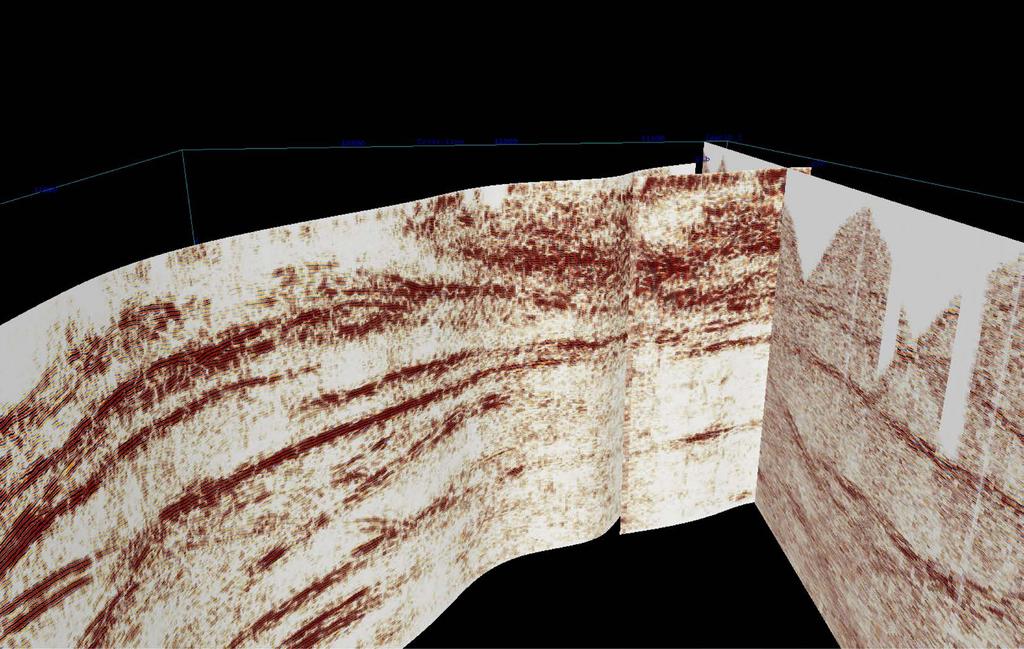
39 High grade Seve Nappe is highly reflective

40 COSC 1

41 Detailed view of initial COSC-1 location

42

43 COSC 2 location not decided Seismic Extension 2011

44 Reflection seismic extension to be acquired 2014 (if funded)
45 COSC: Planned borehole experiments Fully cored boreholes to 2.5 km Borehole geophysical logging Integrated borehole and surface seismic surveys Downhole hydraulic measurements Downhole fluid sampling Long-term (years) temperature monitoring
46 Timing Aug/Sep 2013: Site preparation Oct 2013: Installation of a borehole seismic geophone array to 100 m Apr/May 2014: Core drilling starts Aug 2014:Downhole hydraulic measurements Sep 2014: Borehole seismics Oct 2014: Stress measurements (if funded) 2015: Long-term (years) temperature monitoring (if funded)

47 COSC 1 site, May 2013

48 COSC 1 site, August 2013
49 Summary COSC 1 borehole located: Will penetrate primarily the high grade Seve Nappe Further reflection seismic profiling is required before the COSC 2 borehole can be located: Goals are to penetrate the sole thrust (Alum shale) and at least one basement reflector Boreholes will be fully cored using the Swedish National Drilling Infrastructure Several post drilling experiments planned, including extensive borehole seismic surveys and long term (years) monitoring of temperature Funding is in place for drilling of COSC 1 and drilling will start in April/May 2014 New AMT/MT, geological mapping, petrophysics and potential field data have been acquired in summer
50 Thank you! 50

51 Schematic cross section through the Himalayas


52 Schematic cross section through the Caledonides

53 57
SwedSTORE CO2 : Plans for a Swedish onshore test site for CO 2 storage via seismic surveying and drilling on Gotland, Sweden
 SwedSTORE CO2 : Plans for a Swedish onshore test site for CO 2 storage via seismic surveying and drilling on Gotland, Sweden Christopher Juhlin (Uppsala University) 1 SwedSTORE CO2 Goals Advance methods
Geophysical Journal International
 Geophysical Journal International Geophys. J. Int. (2017) 210, 1332 1346 Advance Access publication 2017 May 20 GJI Seismology doi: 10.1093/gji/ggx223 The derivation of an anisotropic velocity model from
Copyright McGraw-Hill Education. All rights reserved. No reproduction or distribution without the prior written consent of McGraw-Hill Education
 Copyright McGraw-Hill Education. All rights reserved. No reproduction or distribution without the prior written consent of McGraw-Hill Education Tibetan Plateau and Himalaya -southern Asia 11.00.a VE 10X
NAME HOMEWORK ASSIGNMENT #4 MATERIAL COVERS CHAPTERS 19, 20, 21, & 2
 NAME HOMEWORK ASSIGNMENT #4 MATERIAL COVERS CHAPTERS 19, 20, 21, & 2 Assignment is due the beginning of the class period on December 14, 2004. Mark answers on a scantron sheet, which will be provided.
Reactivated basement structures and their control on sandstone-hosted Pb-Zn deposit along the eastern front of the Scandinavian Caledonides
 Proceedings Chapter Reactivated basement structures and their control on sandstone-hosted Pb-Zn deposit along the eastern front of the Scandinavian Caledonides SAINTILAN, Nicolas, et al. Abstract The Laisvall
Chapter 10: Deformation and Mountain Building. Fig. 10.1
 Chapter 10: Deformation and Mountain Building Fig. 10.1 OBJECTIVES Describe the processes of rock deformation and compare and contrast ductile and brittle behavior in rocks. Explain how strike and dip
GLG101: What-To-Know List
 Exam 3, Page 1 GLG101: What-To-Know List (Derived from Before You Leave This Page Lists) This list is intended to guide your reading and to help you prepare for the online multiple-choice quizzes. Each
Plate Tectonics. entirely rock both and rock
 Plate Tectonics I. Tectonics A. Tectonic Forces are forces generated from within Earth causing rock to become. B. 1. The study of the origin and arrangement of Earth surface including mountain belts, continents,
Strike-Slip Faults. ! Fault motion is parallel to the strike of the fault.
 Strike-Slip Faults! Fault motion is parallel to the strike of the fault.! Usually vertical, no hanging-wall/footwall blocks.! Classified by the relative sense of motion. " Right lateral opposite block
TS Tectonics & Structural Geology Orals and PICOs Monday, 08 April
 TS Tectonics & Structural Geology Orals and PICOs Monday, 08 April MO1, 08:30 10:00 MO2, 10:30 12:00 MOL, 12:15 13:15 MO3, 13:30 15:00 MO4, 15:30 17:00 GD3.3/GM3.3/GMPV16/TS4.7, The evolution of plate
Plate Tectonics GEOL 101 Lecture 22 How Are Mountains Built?
 Plate Tectonics GEOL 101 Lecture 22 How Are Mountains Built? The Grand Tetons, Wyoming First a Brief Review of Sea Floor Spreading Prop: Test 3 Invitations Break-Up of a Continent and Origin of an Ocean
Alfred Wegener gave us Continental Drift. Fifty years later...
 CHAPTER 2 Plate Tectonics and the Ocean Floor Plate Tectonics: summary in haiku form Alfred Wegener gave us Continental Drift. Fifty years later... Words Chapter Overview Much evidence supports plate tectonics
The Structure of the Earth and Plate Tectonics
 The Structure of the Earth and Plate Tectonics Structure of the Earth The Earth is made up of 4 main layers: Inner Core Outer Core Mantle Crust Crust Mantle Outer core Inner core The Crust This is where
The Theory of Continental Drift. Continental Drift Discovery
 The Theory of Continental Drift Continental Drift Discovery The World ALFRED WEGENER THEORY OF CONTINENTAL DRIFT Found evidence for PANGAEA and proposed the theory of continental drift. Continental Drift
Essentials of Oceanography Eleventh Edition
 Chapter Chapter 1 2 Clickers Lecture Essentials of Oceanography Eleventh Edition Plate Tectonics and the Ocean Floor Alan P. Trujillo Harold V. Thurman Chapter Overview Much evidence supports plate tectonics
Crustal reflectivity near the Archaean Proterozoic boundary in northern Sweden and implications for the tectonic evolution of the area
 Geophys. J. Int. (2002) 150, 180 197 Crustal reflectivity near the Archaean Proterozoic boundary in northern Sweden and implications for the tectonic evolution of the area C. Juhlin, 1 S.-A. Elming, 2
Tectonic plates of the world
 Mountain Building Tectonic plates of the world ISOSTACY Isostatic Rebound crust rises as a result of removal of mass This iceberg also demonstrates the process of isostatic rebound. Types of Mountains
Down-stream process transition (f (q s ) = 1)
 = 1)") Down-stream process transition (f (q s ) = 1) Detachment Limited S d >> S t Transport Limited Channel Gradient (m/m) 10-1 Stochastic Variation { Detachment Limited Equilibrium Slope S d = k sd A -θ d S
Down-stream process transition (f (q s ) = 1) Detachment Limited S d >> S t Transport Limited Channel Gradient (m/m) 10-1 Stochastic Variation { Detachment Limited Equilibrium Slope S d = k sd A -θ d S
Geotechnical Deskstudy for Proposed Windfarm NV NORDISK VINDKRAFT AB. Fjällberg. Östersund , rev Fjällberg
 NV NORDISK VINDKRAFT AB Östersund 23-06-2011, rev 06-07-2012 Geotechnical Deskstudy for Proposed Windfarm Date 23-06-2011, rev 06-07-2012 Project number 61811144691000 JONSSON EVA TAJANI KRISTINA TAJANI
Geodynamics. Climatic, geomorphic and geodynamic processes Lecture Orogenic wedges. Lecturer: David Whipp
 Geodynamics Climatic, geomorphic and geodynamic processes Lecture 13.3 - Orogenic wedges Lecturer: David Whipp david.whipp@helsinki.fi Geodynamics www.helsinki.fi/yliopisto 1 Goals of this lecture Introduce
Dr. Yildirim Dilek Department of Earth Sciences Miami University, USA
 Dr. Yildirim Dilek Department of Earth Sciences Miami University, USA 40 years of successful, field-based, inter-disciplinary exploration of the Earth processes and training of the future generations of
 Sedimentary Basin Analysis http://eqsun.geo.arizona.edu/geo5xx/geos517/ Sedimentary basins can be classified based on the type of plate motions (divergent, convergent), type of the lithosphere, distance
Modern geodynamic model of the Arctic Ocean
 Modern geodynamic model of the Arctic Ocean O. Petrov, N. Sobolev, A. Morozov, G. Grikurov, S. Shokalsky, S. Kashubin, E. Petrov Vienna, April 2012 Atlas of Geological Maps of the Circumpolar Arctic Magnetic
Plate Tectonics. Essentials of Geology, 11 th edition Chapter 15
 1 Plate Tectonics Essentials of Geology, 11 th edition Chapter 15 2 3 4 5 6 7 8 9 10 11 12 13 14 15 Plate Tectonics: summary in haiku form Alfred Wegener gave us Continental Drift. Fifty years later...
Earth s Interior: Big Ideas. Structure of the Earth
 Earth s Interior: Big Ideas Earth science investigations take many different forms. Earth scientists do reproducible experiments and collect multiple lines of evidence. Our understanding of Earth is continuously
TAKE HOME EXAM 8R - Geology
 Name Period Date TAKE HOME EXAM 8R - Geology PART 1 - Multiple Choice 1. A volcanic cone made up of alternating layers of lava and rock particles is a cone. a. cinder b. lava c. shield d. composite 2.
New Progress of SinoProbe:
 New Progress of SinoProbe: Deep Exploration in China, 2008-2012 Shuwen DONG, Tingdong LI, et al. Chinese Academy of Geological Sciences Beijing 100037 China Background of Deep Exploration in World USA
Mo MIN 02 Downhole Physical Properties Measurements Supporting Iron-oxide Deep Exploration and Mining in Blötberget, Sweden
 Mo MIN 02 Downhole Physical Properties Measurements Supporting Iron-oxide Deep Exploration and Mining in Blötberget, Sweden G. Maries* (Uppsala University), A. Malehmir (Uppsala University) & E. Backstrom
Evolution of Continents Chapter 20
 Evolution of Continents Chapter 20 Does not contain complete lecture notes. Mountain belts Orogenesis the processes that collectively produce a mountain belt Includes folding, thrust faulting, metamorphism,
1.72, Groundwater Hydrology Prof. Charles Harvey Lecture Packet #5: Groundwater Flow Patterns. Local Flow System. Intermediate Flow System
 1.72, Groundwater Hydrology Prof. Charles Harvey Lecture Packet #5: Groundwater Flow Patterns c Local Flow System 10,000 feet Intermediate Flow System Regional Flow System 20,000 feet Hydrologic section
Why does the Earth have volcanoes? Why is there Earthquakes?
 Why does the Earth have volcanoes? Why is there Earthquakes? Turn to your neighbor and review: How and when did the Earth form? How old are the first traces of life on Earth? Logical? * 1.5Ga (1 st multicellular
Deep Borehole Disposal Performance Assessment and Criteria for Site Selection
 Deep Borehole Disposal Performance Assessment and Criteria for Site Selection Sandia is a multiprogram laboratory operated by Sandia Corporation, a Lockheed Martin Company, for the United States Department
5. Gravity. 5.1 Geoid Variations. The Australian Continent: A Geophysical Synthesis Gravity
 34 The Australian Continent: A Geophysical Synthesis Gravity 5. Gravity Gravity data map subtle changes in the Earth s gravitational field caused by variations in the density of the underlying materials.
IODP drilling and core storage facilities
 4 IODP drilling and core storage facilities Neville Exon As the knowledge obtainable from ocean drilling is various and extensive, its end-users are similarly various and extensive. Scientific ocean drilling
Instructional Objectives
 GE 6477 DISCONTINUOUS ROCK 8. Fracture Detection Dr. Norbert H. Maerz Missouri University of Science and Technology (573) 341-6714 norbert@mst.edu Instructional Objectives 1. List the advantages and disadvantages
12/3/2014. Plate Tectonics: A Scientific Revolution Unfolds Earth Science, 13e Chapter 7. Continental drift: an idea before its time
 Plate Tectonics: A Scientific Revolution Unfolds Earth Science, 13e Chapter 7 Stanley C. Hatfield Southwestern Illinois College Continental drift: an idea before its time Alfred Wegener First proposed
Earthscope in the Northern Rockies Workshop
 Earthscope in the Northern Rockies Workshop Co-conveners: David Foster - University of Florida Paul Mueller - University of Florida David Mogk - Montana State University EarthScope in the Northern Rockies
Chapter 2 Plate Tectonics and the Ocean Floor
 Chapter 2 Plate Tectonics and the Ocean Floor Chapter Overview Much evidence supports plate tectonics theory. The plate tectonics model describes features and processes on Earth. Plate tectonic science
Earth Dynamics. Landforms at Plate Boundaries
 Earth Dynamics CHAPTER 8 LESSON 2 Landforms at Boundaries What do you think? Read the two statements below and decide whether you agree or disagree with them. Place an A in the Before column if you agree
Introduction to Oceanography. Chapter 2: Plate Tectonics Overview
 Introduction to Oceanography Chapter 2: Plate Tectonics Overview Much evidence supports plate tectonics theory. The plate tectonics model describes features and processes on Earth. Plate tectonic science
Introduction To Plate Tectonics Evolution. (Continents, Ocean Basins, Mountains and Continental Margins)
") Introduction To Plate Tectonics Evolution (Continents, Ocean Basins, Mountains and Continental Margins) Geo 386 (Arabian Shield Course) Dr. Bassam A. A. Abuamarah Mohanna G E O 3 8 6 A R A B I A N G E
Introduction To Plate Tectonics Evolution (Continents, Ocean Basins, Mountains and Continental Margins) Geo 386 (Arabian Shield Course) Dr. Bassam A. A. Abuamarah Mohanna G E O 3 8 6 A R A B I A N G E
TEMPERATURE LOGGING IN PERFORATED WELLS
 PROCEEDINGS, Thirty-First Workshop on Geothermal Reservoir Engineering Stanford University, Stanford, California, January 30-February 1, 2006 SGP-TR-179 TEMPERATURE LOGGING IN PERFORATED WELLS Per-Gunnar
Before Plate Tectonics: Theory of Continental Drift
 Before Plate Tectonics: Theory of Continental Drift Predecessor to modern plate tectonics Shape and fit of the continents was the initial evidence Snider-Pelligrini (1858) Taylor (1908) Wegner (1915) Fig.
FIRE transects: New images of the Precambrian crust
 LITOSPHERE 10.- 11.11.2004 Page 11 FIRE transects: New images of the Precambrian crust Pekka Heikkinen 1, Ilmo T. Kukkonen 2, Elias Ekdahl 2, Sven-Erik Hjelt 3, Annakaisa Korja 1, Raimo Lahtinen 2, Jukka
Section 2: How Mountains Form
 Section 2: How Mountains Form Preview Objectives Mountain Ranges and Systems Plate Tectonics and Mountains Types of Mountains Objectives Identify the types of plate collisions that form mountains. Identify
Grand Unifying Theory of everything... for the Geosciences, at least!
 Plate Tectonics: Grand Unifying Theory of everything... for the Geosciences, at least! The Earth s lithosphere, composed of Oceanic and continental crust, is broken up into pieces that move and interact
SEISMIC SURVEYS FOR IMAGING THE REGOLITH
 SEISMIC SURVEYS FOR IMAGING THE REGOLITH Barry Drummond Geoscience Australia. PO Box 378, Canberra, ACT 2601. E-mail: barry.drummond@ga.gov.au 1. INTRODUCTION Seismic reflection and refraction imaging
Mountains are then built by deforming crust: Deformation & Mountain Building. Mountains form where stresses are high!
 Deformation & Mountain Building Where are mountains located? Deformation and Folding Mountain building Mountains form where stresses are high! Mountains form at all three types of plate boundaries where
The Greenland Analogue Project
 The Greenland Analogue Project Jon Engström, GTK Lillemor Claesson Liljedahl, SKB Anne Kontula, Posiva Oy Timo Ruskeeniemi, GTK NAWG-15, Prague 24.5.2017 The Greenland Analogue Project Greenland Analogue
ANOTHER MEXICAN EARTHQUAKE! Magnitude 7.1, Tuesday Sept. 19, 2017
 ANOTHER MEXICAN EARTHQUAKE! Magnitude 7.1, Tuesday Sept. 19, 2017 Why is there no oceanic crust older than 200 million years? SUBDUCTION If new oceanic crust is being continuously created along the earth
Arc-Continent Collision
 Frontiers in Earth Sciences Arc-Continent Collision Bearbeitet von Dennis Brown, Paul D Ryan 1. Auflage 2011. Buch. xiii, 495 S. Hardcover ISBN 978 3 540 88557 3 Format (B x L): 19,3 x 26 cm Weitere Fachgebiete
Downhole Physical Properties Measurements Supporting Iron-oxide Deep Exploration and Mining in Blötberget, Sweden
 Downhole Physical Properties Measurements Supporting Iron-oxide Deep Exploration and Mining in Blötberget, Sweden Georgiana Maries 1, Alireza Malehmir 1, Emma Backstrom 2 1 Uppsala University 2 NIO Motivation
RAYMOND SIEVER Harvard University
 E A R T H FOURTH EDITION FRANK PRESS National Academy of Sciences RAYMOND SIEVER Harvard University W. H. Freeman and Company New York Preface xiii Acknowledgments xviii PART I PROLOGUE CHAPTER 1 HISTORY
Plate Tectonics. I. The Discovery of Plate Tectonics II. A Mosaic of Plates III. Types of Plate Boundaries IV. How Plates Move
 Plate Tectonics I. The Discovery of Plate Tectonics II. A Mosaic of Plates III. Types of Plate Boundaries IV. How Plates Move I. The Discovery of Plate Tectonics A. Continental Drift (Alfred Wegener) Proposed
Global Tectonics. Kearey, Philip. Table of Contents ISBN-13: Historical perspective. 2. The interior of the Earth.
 Global Tectonics Kearey, Philip ISBN-13: 9781405107778 Table of Contents Preface. Acknowledgments. 1. Historical perspective. 1.1 Continental drift. 1.2 Sea floor spreading and the birth of plate tectonics.
Ann Moulding and Tom Brikowski University of Texas at Dallas, Department of Geosciences
 GRC Transactions, Vol. 39, 2015 Influence of Continuously Variable Permeability and Basin Rock Properties on Three Dimensional Heat and Mass Balance Models of Basin & Range Geothermal Systems Ann Moulding
12. The diagram below shows the collision of an oceanic plate and a continental plate.
 Review 1. Base your answer to the following question on the cross section below, which shows the boundary between two lithospheric plates. Point X is a location in the continental lithosphere. The depth
Estimation of Pore Pressure from Well logs: A theoretical analysis and Case Study from an Offshore Basin, North Sea
 P-217 Estimation of Pore Pressure from Well logs: A theoretical analysis and Case Study from an Offshore Basin, North Sea Pritam Bera Final Year, M.Sc.Tech. (Applied Geophysics) Summary This paper concerns
GEOLOGIC MAPS PART II
 EARTH AND ENVIRONMENT THROUGH TIME LABORATORY - EES 1005 LABORATORY FIVE GEOLOGIC MAPS PART II Introduction Geologic maps of orogenic belts are much more complex than maps of the stable interior. Just
Deformation of Rocks. Orientation of Deformed Rocks
 Deformation of Rocks Folds and faults are geologic structures caused by deformation. Structural geology is the study of the deformation of rocks and its effects. Fig. 7.1 Orientation of Deformed Rocks
This is the published version of a paper presented at LITHOSPHERE 2016 Symposium, November 9-11, 2016, Espoo, Finland.
 http://www.diva-portal.org This is the published version of a paper presented at LITHOSPHERE 2016 Symposium, November 9-11, 2016, Espoo, Finland. Citation for the original published paper: Buntin, S.,
Pia Sandvik Wiklund President
 1 Pia Sandvik Wiklund President 2 The University our strengths Leading-edge research Applied research Multidisciplinary Focus areas and development areas Our geographical location - climate Warm and welcoming
The Structure of the Earth and Plate Tectonics
 The Structure of the Earth and Plate Tectonics Agree or Disagree? 1. The Earth if made up of 4 different layers. 2. The crust (where we live) can be made of either less dense continental crust or the more
GENERAL GEOLOGY Fall Chapter 18: The Sea Floor. Partial Examination IV Study Guide Dr. Glen S. Mattioli
 GENERAL GEOLOGY 1113-005 Fall 2008 Partial Examination IV Study Guide Dr. Glen S. Mattioli Note that these are NOT questions, but rather are a list of topics that we have covered either in class or are
Chapter. Graphics by Tasa Graphic Arts. Inc.
 Earth Chapter Plate Science 9 Tectonics Graphics by Tasa Graphic Arts. Inc. 1 I. Earth s surface is made up of lithospheric plates. A. Lithospheric plates are composed of the crust and part of the upper
Seismic Reflection Imaging across the Johnson Ranch, Valley County, Idaho
 Seismic Reflection Imaging across the Johnson Ranch, Valley County, Idaho Report Prepared for the Skyline Corporation Lee M. Liberty Center for Geophysical Investigation of the Shallow Subsurface (CGISS)
Review participation point: The evidence for a fluid outer core is:
 DDA1 Continental Drift to Plate Tectonics PS 100 Chapter 28 Review participation point: The evidence for a fluid outer core is: A. Average density of the earth is greater than the density of the crust.
The UK GeoEnergy Test Bed Ceri J Vincent British Geological Survey
 The UK GeoEnergy Test Bed Ceri J Vincent British Geological Survey Thanks to Matthew Hall (GTB Theme Lead for G ERA), Phil Meldrum, Russell Swift, Oliver Kuras, Richard Luckett, Andrew Butcher, Jonathan
I. Earth s Layers a. Crust: Earth s outside layer. Made of mostly rock. i. Continental: er; made of mostly granite, forms the continents and shallow
 I. Earth s Layers a. Crust: Earth s outside layer. Made of mostly rock. i. Continental: er; made of mostly granite, forms the continents and shallow sea beds, floats! ii. Oceanic: er; dense rock such as
Chapter 9. ASTRONOMY 202 Spring 2007: Solar System Exploration. Class 26: Planetary Geology [3/23/07] Announcements.
![Chapter 9. ASTRONOMY 202 Spring 2007: Solar System Exploration. Class 26: Planetary Geology [3/23/07] Announcements.](/thumbs/87/96235120.jpg "Chapter 9. ASTRONOMY 202 Spring 2007: Solar System Exploration. Class 26: Planetary Geology [3/23/07] Announcements.") ASTRONOMY 202 Spring 2007: Solar System Exploration Instructor: Dr. David Alexander Web-site: www.ruf.rice.edu/~dalex/astr202_s07 Class 26: Planetary Geology [3/23/07] Announcements Planetary Geology Planetary
ASTRONOMY 202 Spring 2007: Solar System Exploration Instructor: Dr. David Alexander Web-site: www.ruf.rice.edu/~dalex/astr202_s07 Class 26: Planetary Geology [3/23/07] Announcements Planetary Geology Planetary
FINAL EXAM Crustal Deformation CONVERGE DIVERGENT PLATES MANTLE PLUMES FLUX BASALTIC GRANITIC
 Crustal Deformation Reading: Chapter 10 Pages 283-304 Review Questions 4, 6, 7, 10, 12, 15, 18, 20 FINAL EXAM NOON TO 2 PM, TUESDAY DEC. 5 HERE: Natural Science 101 BRING A SCAN TRON TURN IN YOUR REVIEW
Risk Evaluation. Todd Shipman PhD, Alberta Geological Survey/Alberta Energy Regulator November 17 th,2017 Induced Seismicity Workshop, Yellowknife NWT
 Risk Evaluation Todd Shipman PhD, Alberta Geological Survey/Alberta Energy Regulator November 17 th,2017 Induced Seismicity Workshop, Yellowknife NWT Risk Management Approach to Induced Seismicity Establishing
Prentice Hall EARTH SCIENCE
 Prentice Hall EARTH SCIENCE Tarbuck Lutgens Chapter 9 Plate Tectonics 9.1 Continental Drift An Idea Before Its Time Wegener s continental drift hypothesis stated that the continents had once been joined
Prentice Hall EARTH SCIENCE
 Prentice Hall EARTH SCIENCE Tarbuck Lutgens Chapter 9 Plate Tectonics 9.1 Continental Drift An Idea Before Its Time Wegener s continental drift hypothesis stated that the continents had once been joined
Marine Science and Oceanography
 Marine Science and Oceanography Marine geology- study of the ocean floor Physical oceanography- study of waves, currents, and tides Marine biology study of nature and distribution of marine organisms Chemical
Distribution of Continents Mid-ocean Ridges Trenches. Deformation Metamorphism Volcanism Earthquakes
 Earthquakes and Plate Tectonics Global Problems in Geology Distribution of Continents Mid-ocean Ridges Trenches Orogenic Belts Deformation Metamorphism Volcanism Earthquakes Development of Continental
Hydrogeology of Deep Borehole Disposal for High-Level Radioactive Waste
 SAND2014-18615C Hydrogeology of Deep Borehole Disposal for High-Level Radioactive Waste Geological Society of America Annual Meeting October 20, 2014 Bill W. Arnold, W. Payton Gardner, and Patrick V. Brady
Continental Drift and Plate Tectonics
 Continental Drift and Plate Tectonics Continental Drift Wegener s continental drift hypothesis stated that the continents had once been joined to form a single supercontinent. Wegener proposed that the
CONTENT. A. Changes in the Crust Facts Changes Construction and Destruction. B. Continental Drift What is it? Evidence
 Name Earth Science Date Period TOPIC THE DYNAMIC EARTH CONTENT A. Changes in the Crust Facts Changes Construction and Destruction B. Continental Drift What is it? Evidence C. Theory of Plate Tectonics
Geothermal Energy from Impact Craters? The Björkö Study
 Proceedings World Geothermal Congress 2005 Antalya, Turkey, 24-29 April 2005 Geothermal Energy from Impact Craters? The Björkö Study Herbert Henkel 1, Ann Bäckström 1, Börje Bergman 2, Ove Stephansson
Mountain Building. Mountain Building
 Mountain Building Mountain building has occurred during the recent geologic past American Cordillera the western margin of the Americas from Cape Horn to Alaska Includes the Andes and Rocky Mountains Alpine
Earth. Temp. increases with depth, the thermal gradient is 25 o C/km. Pressure and density also increase with depth.
 Plate Tectonics Earth Earth overall average density = 5.5 g/cm 3. Temp. increases with depth, the thermal gradient is 25 o C/km. Pressure and density also increase with depth. Spheroid: with a longer major
Non-ideal Subduction
 Subduction zone cross sections Earthquake locations : black = teleseismic est. gray = local-array est. red line = top of slab seismicity blue line = center of slab seismicity Non-ideal Subduction Oblique
Earth Science Lesson Plan Quarter 3, Week 7, Day 1
 Earth Science Lesson Plan Quarter 3, Week 7, Day 1 Outcomes for Today Standard Focus: PREPARE 1. Background knowledge necessary for today s reading. Continental ice sheets increase the weight of the Earth
3. Continental Heat Flow. Ge 163 4/3/15
 3. Continental Heat Flow Ge 163 4/3/15 Outline 1. Measurement of heat flow and Fourier s law 2. Overview of major variations 3. Sclater Histograms 4. Heat-flow - heat-production relationship 5. Continental
The San Andreas Fault Observatory at Depth: Recent Site Characterization Studies and the 2.2-Km-Deep Pilot Hole
 The San Andreas Fault Observatory at Depth: Recent Site Characterization Studies and the 2.2-Km-Deep Pilot Hole Steve Hickman and Bill Ellsworth (USGS) Mark Zoback (Stanford University) and the Pre-EarthScope
Information From Walk-Away VSP and Cross-Hole DataUsing Various Wave Modes: Tower Colliery, South Sydney Basin
 Seismic Methods in Mineral Exploration Paper 58 Explor97 Master Page Explor97 Contents Previous Paper G O T O Author Index Section Contents Next Paper Information From Walk-Away VSP and Cross-Hole DataUsing
Sandia National Laboratories
 Photos placed in horizontal position with even amount of white space between photos and header The U.S. Deep Borehole Field Test Patrick V. Brady, Kristopher L. Kuhlman, David L. Sassani, Geoffrey A. Freeze,
Recommendations for Injection and Storage Monitoring
 Energy and Environmental Systems Group Institute for Sustainable Energy, Environment and Economy (ISEEE) Recommendations for Injection and Storage Monitoring WABAMUN AREA CO 2 SEQUESTRATION PROJECT (WASP)
Site Characterization & Hydrogeophysics
 Site Characterization & Hydrogeophysics (Source: Matthew Becker, California State University) Site Characterization Definition: quantitative description of the hydraulic, geologic, and chemical properties
Directed Reading. Section: How Mountains Form MOUNTAIN RANGES AND SYSTEMS. Skills Worksheet
 Skills Worksheet Directed Reading Section: How Mountains Form 1. How high is Mount Everest? a. about 1980 km above sea level b. more than 8 km below sea level c. more than 8 km above sea level d. more
The Building of the NYC Region
 The Building of the NYC Region Definitions Fall Line marks the area where an upland region (continental bedrock) and a coastal plain meet Piedmont the plateau region of the eastern United States which
University of Leeds 3GP Geophysics Field Trip Lake Balaton, Hungary
 University of Leeds 3GP Geophysics Field Trip Lake Balaton, Hungary September 1-15, 2007 geological background and logistics Staff: Greg Houseman, Graham Stuart The Alpine-Carpathian-Pannonian System Elevation
Tectonophysics 653 (2015) Contents lists available at ScienceDirect. Tectonophysics. journal homepage:
 Contents lists available at ScienceDirect. Tectonophysics. journal homepage:") Tectonophysics 653 (2015) 1 19 Contents lists available at ScienceDirect Tectonophysics journal homepage: www.elsevier.com/locate/tecto Magnetotelluric array data analysis from north-west Fennoscandia
Tectonophysics 653 (2015) 1 19 Contents lists available at ScienceDirect Tectonophysics journal homepage: www.elsevier.com/locate/tecto Magnetotelluric array data analysis from north-west Fennoscandia
Geos Orogeny-mountain building: existing mountain belts are the result of Cenozoic tectonics. Cenozoic tectonism and climate.
 Geos 432-2 Cenozoic tectonism and climates; climate change Orogeny-mountain building: existing mountain belts are the result of Cenozoic tectonics Cenozoic tectonism and climate Movement of continents
TEST NAME:Geology part 1 TEST ID: GRADE:06 - Sixth Grade SUBJECT:Life and Physical Sciences TEST CATEGORY: My Classroom
 TEST NAME:Geology part 1 TEST ID:1542715 GRADE:06 - Sixth Grade SUBJECT:Life and Physical Sciences TEST CATEGORY: My Classroom Geology part 1 Page 1 of 6 Student: Class: Date: 1. The picture below shows
Phanerozoic (last 0.54 by) Tectonics Climate Life
 Tectonics Climate Life") Phanerozoic (last 0.54 by) Tectonics Climate Life Tools for Locating Past Continent Positions Fossils depending on climate Alignment of geological features Geometrical fit of continental margins Similarity
Phanerozoic (last 0.54 by) Tectonics Climate Life Tools for Locating Past Continent Positions Fossils depending on climate Alignment of geological features Geometrical fit of continental margins Similarity
Quantification of the 3D thermal anomaly in the orogenic geothermal system at Grimsel Pass
 Quantification of the 3D thermal anomaly in the orogenic geothermal system at Grimsel Pass Christoph Wanner, Larryn W. Diamond, Peter Alt-Epping, Daniel Egli Rock-Water Interaction Group, Institute of
Comparison of Microseismic Results in Complex Geologies Reveals the Effect of Local Stresses on Fracture Propagation
 Comparison of Microseismic Results in Complex Geologies Reveals the Effect of Local Stresses on Fracture Propagation Mike Preiksaitis, Sheri Bowman, Ted Urbancic ESG Canada Inc. Summary Understanding the
USU 1360 TECTONICS / PROCESSES
 USU 1360 TECTONICS / PROCESSES Observe the world map and each enlargement Pacific Northwest Tibet South America Japan 03.00.a1 South Atlantic Arabian Peninsula Observe features near the Pacific Northwest