New Mexico Geological Society
|
|
|
- Rosalind Lang
- 5 years ago
- Views:
Transcription

1 New Mexico Geological Society Downloaded from: Quaternary and Pliocene faults in the La Jencia and southern part of the Albuquerque-Belen Basins, New Mexico--Evidence of fault history from fault-scarp morphology and Quaternary geology Michael N. Machette, 1982, pp in: Albuquerque Country II, Wells, S. G.; Grambling, J. A.; Callender, J. F.; [eds.], New Mexico Geological Society 33 rd Annual Fall Field Conference Guidebook, 370 p. This is one of many related papers that were included in the 1982 NMGS Fall Field Conference Guidebook. Annual NMGS Fall Field Conference Guidebooks Every fall since 1950, the New Mexico Geological Society (NMGS) has held an annual Fall Field Conference that explores some region of New Mexico (or surrounding states). Always well attended, these conferences provide a guidebook to participants. Besides detailed road logs, the guidebooks contain many well written, edited, and peer-reviewed geoscience papers. These books have set the national standard for geologic guidebooks and are an essential geologic reference for anyone working in or around New Mexico. Free Downloads NMGS has decided to make peer-reviewed papers from our Fall Field Conference guidebooks available for free download. Non-members will have access to guidebook papers two years after publication. Members have access to all papers. This is in keeping with our mission of promoting interest, research, and cooperation regarding geology in New Mexico. However, guidebook sales represent a significant proportion of our operating budget. Therefore, only research papers are available for download. Road logs, mini-papers, maps, stratigraphic charts, and other selected content are available only in the printed guidebooks. Copyright Information Publications of the New Mexico Geological Society, printed and electronic, are protected by the copyright laws of the United States. No material from the NMGS website, or printed and electronic publications, may be reprinted or redistributed without NMGS permission. Contact us for permission to reprint portions of any of our publications. One printed copy of any materials from the NMGS website or our print and electronic publications may be made for individual use without our permission. Teachers and students may make unlimited copies for educational use. Any other use of these materials requires explicit permission.
2 This page is intentionally left blank to maintain order of facing pages.
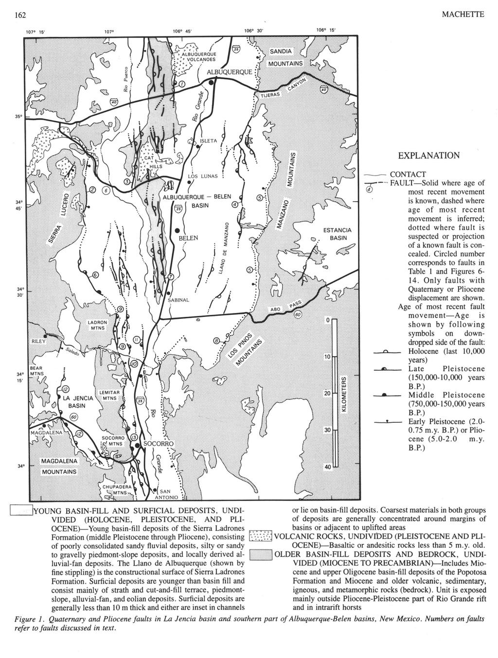
3 New Mexico Geological Society Guidebook, 33rd Field Conference, Albuquerque Country II, QUATERNARY AND PLIOCENE FAULTS IN THE LA JENCIA AND SOUTHERN PART OF THE ALBUQUERQUE-BELEN BASINS, NEW MEXICO: EVIDENCE OF FAULT HISTORY FROM FAULT-SCARP MORPHOLOGY AND QUATERNARY GEOLOGY MICHAEL N. MACHETTE U.S. Geological Survey MS 913, Federal Center Denver, Colorado INTRODUCTION The La Jencia and Albuquerque-Belen basins are two of the main structural depressions in the central part of the Rio Grande rift of New Mexico. Within these two basins are many faults that displace basinfill deposits of Pliocene and Quaternary age and surficial deposits of middle and late Quaternary age. None of the faults I have studied in these basins show evidence of historical ground breakage; however, several show evidence of Holocene movement, and many show evidence of late Pleistocene movement. Recently published neotectonic maps of the Rio Grande rift (Woodward and others, 1975; Hawley, 1978) included many of the faults described in this report; however, no systematic study of ages or amounts of fault movement has been made previously. This report considers only faults with Quaternary or Pliocene movement and includes information on the amount of fault displacement, the age of displaced deposits, the recency of fault movement, and the morphology of some fault scarps. These data were derived from published and unpublished geologic maps and reports, from low-altitude aerial photography, from studies of Quaternary deposits along the faults, and from an analysis of fault-scarp morphology. Where several sources of map data were available, I used those compiled at larger scales and those that focus on late Cenozoic structure and stratigraphy. The faults shown on the map (fig. 1) provide direct evidence of Quaternary or Pliocene movement; those faults that lie entirely within Miocene or older rocks are not shown. The reader should be aware of this selection, especially if data from this report are used in hazards assessment, in regional structural analysis, or in other studies. PLIOCENE AND QUATERNARY GEOLOGY OF THE CENTRAL RIO GRANDE RIFT Because the main subject of this report is the faults that displace Pliocene and Quaternary deposits in the central part of the Rio Grande rift, I do not discuss the pre-pliocene geology other than to cite several recent reports, including discussions of the evolution of the Rio Grande rift by Chapin and Seager (1975) and of the geology of the Albuquerque basin by Kelley (1977), the guidebook of the Rio Grande rift compiled by Hawley (1978), and the recent mapping of late Cenozoic basin-fill and surfical deposits in the southern part of the Albuquerque-Belen basin by Machette (1978b, c). The following discussion is drawn from these reports and my own work. Many of the mountain ranges adjacent to the modern Rio Grande rift were uplifted during late Miocene to early Pliocene time. Thick sections of lower-to-upper? Miocene sedimentary rocks of the Popotosa Formation in these ranges are separated from Pliocene and Pleistocene basin-fill deposits by a marked angular unconformity around the margins of the basins. The Popotosa Formation is extensively faulted and tilted as much as 60'; whereas, the younger basin-fill deposits are moderately deformed only near major faults. The late Miocene to early Pliocene episode of uplift formed basins that are structurally distinct from and more highly integrated than those in which the Miocene Popotosa Formation accumulated. The formation of these new basins and ranges was accompanied by as much as 1,100 m of regional epeirogenic uplift in the southern Rocky Mountains and by increased amounts of annual precipitation and runoff from the elevated mountainous areas. By early Pliocene time, the upper reach of the Rio Grande formed a major drainage system that flowed through a series of structural basins from southern Colorado to southern New Mexico and northern Mexico. Basinfill sediment of the Sierra Ladrones Formation was deposited by the upper Rio Grande and its tributary streams from about 4.5 to about 0.5 m.y. ago. The distributary end of the upper Rio Grande fluvial system was situated in the basins of southern New Mexico and northern Mexico at altitudes of about 1,200 to 1,400 m above sea level. Contemporaneously, the lower reach of the Rio Grande system and its tributaries such as the Pecos River drained much of southeastern New Mexico, northeastern Mexico, and southern Texas. About 0.5 m.y. ago, the upper and lower reaches of the Rio Grande became connected near El Paso, Texas (Hawley and others, 1976), to form a major river system about 2,400 km long. Since 0.5 m.y. ago, the upper reaches of the Rio Grande in New Mexico and Colorado have been downcutting in response to climatic fluctuations and the gradual upstream gradation caused by a new base level at the Gulf of Mexico. Aggradation of the Sierra Ladrones Formation formed a widespread constructional surface in the Albuquerque-Belen basin. This surface, called the Llano de Albuquerque, in many places represents the relict 0.5-m.y.-old floodplain of the Rio Grande. The Llano de Albuquerque now lies 100 to 200 m above the modern floodplain of the Rio Grande and forms a widespread datum over much of the central part of the Albuquerque-Belen basin. Below and adjacent to the Llano de Albuquerque, a series of piedmont-slope and associated terrace surfaces, graded to former levels of the Rio Grande and its tributaries, have formed by downcutting during the past 0.5 m.y. Areas away from the influence of the Rio Grande drainage system are generally characterized by aggrading sequences of surficial deposits. Most of the basins in the central Rio Grande rift are 20 to 40 km wide, and sediment shed from the mountain fronts around the margins of these basins is isolated from the drainage of the Rio Grande system. Additionally, some isolated basins, such as the La Jencia and Estancia, have been topographically closed during parts of the Pleistocene. Thus, in both these sedimentologically isolated areas, the surface materials generally record an interval of mainly late Pleistocene and Holocene deposition. METHODS FOR DETERMINING AGES OF FAULTING Two methods are used in this study to determine the ages of fault movement. The first and more traditional method is a stratigraphic
4
5 QUATERNARY FAULTING 163 approach, by which the ages of faulted and unfaulted deposits provide limits to the age of faulting; multiple episodes of fault movement can be determined by comparing the cumulative amounts of displacement in deposits of different ages. A second and less traditional method is through a quantitative analysis of fault-scarp morphology, as discussed in a following section. Stratigraphic Methods The young basin-fill deposits, surficial deposits, and many of the faults were mapped previously by Kelley (1977) and Machette (1978b, d). In this study, the ages of the surficial deposits are based on a combination of factors such as degree of landform preservation, stratigraphic and topographic position, and soil development. The surficial deposits and young basin-fill deposits are grouped in this study into four age categories to show the age of movements along many of the faults (fig. 1). The oldest deposits, of Pliocene and lower Pleistocene age ( m.y. B.P.), include locally derived basalt and all but the youngest part of the Sierra Ladrones Formation. The middle Pleistocene (750, ,00 years B.P.) deposits include the youngest parts of the Sierra Ladrones Formation, which commonly underlie the Llano de Albuquerque; these deposits also include younger alluvial units such as the alluvium underlying the Llano de Manzano surface and alluvial units F through H of Machette (1978b). The late Pleistocene (150,000-10,000 years B.P.) deposits include the alluviums of Edith Avenue and Menaul Boulevard of Lambert (1968) and alluvial units C through E of Machette (1978b). The Holocene deposits include alluvium that forms terraces, fioodplains, and alluvial-fans, and eolian sand that is common on the leeward side of major stream channels or ancient playa and lake basins. Fault-Scarp Morphology The amount of surface displacement and recency of fault movement were estimated from such morphometric parameters as scarp height and maximum scarp-slope angle measurements, which were taken from topographic profiles of fault scarps. In addition, morphologic variations along fault scarps and along portions of scarps formed in deposits of different ages are used in this study as evidence for differential movement along discrete segments of individual faults. My reconnaissance studies along the Rio Grande rift indicate that some Quaternary faults have broken separately along discrete segments at various times in the past, just as R. E. Wallace (written commun., 1982) has shown for historical fault scarps along a seismic belt trending from central Nevada into eastern California. Recent studies of the geomorphology of late Quaternary fault scarps and the processes leading to their time-dependent degradation have established the basis by which the relative ages of fault scarps may be determined independently of stratigraphic methods. The relation between fault-scarp height and maximum fault-scarp-slope angle recognized by Bucknam and Anderson (1979) is used as a criterion for determining the recency of fault movement. This relation is based on the premise that scarps formed by high-angle faults are nearly vertical and that the free faces of these scarps rapidly collapse to the angle of repose of the faulted materials (Wallace, 1977). The collapse of free faces probably occurs in as little as a hundred to perhaps a thousand years. After reaching gravitational equilibrium, scarps continue to degrade by the processes of colluviation and slopewash, though at lower rates than by gravitational collapse. The degree of fault-scarp degradation, measured by the height-dependent reduction in maximum scarpslope angle, provides a quantitative basis for determining fault-scarp ages. Scarp-morphology data were derived from detailed topographic traverses made perpendicular to the trace of fault scarps, according to the methods of Bucknam and Anderson (1979). Scarp height H (in meters) is the graphically determined vertical separation between intersections of the plane formed by the steepest part of the fault scarp (maximum scarp-slope angle 0, fig. 2) and the planes formed by the displaced upper and lower surfaces (surface-slope angle y, fig. 2). The maximum scarp-slope angle 0 is the average of four to six measurements made adjacent to the traverse over a distance of 10 to 20 percent of the scarp width. Each scarp profile (topographic traverse) yields two data pairs (H, 0); to be a statistically valid population, data sets for single, continuous scarps must contain seven or more data pairs. Several data sets were collected along discontinuous fault scarps, or those which form an en echelon pattern or show evidence of segmentation. Scarp data were collected only for faults in unconsolidated deposits (generally Quaternary) because, as yet, the processes and rates of degradation of fault scarps formed in rock are poorly understood. Bucknam and Anderson (1979) reported a significant correlation between the height H and the maximum slope-angle 0 of topographic scarps formed by faulting and wave erosion. The highest wave-cut parts of the Lake Bonneville shoreline were formed during a relatively brief timespan and, as such, provide a widespread datum for morphometric analysis. Bucknam and Anderson (1979) noted that, when plotted against height, 91 percent of the variation (r 2) in the maximum scarp-slope angle 0 of the shoreline could be explained by the linear-regression equation 0 = (log H) (R. C. Bucknam, written commun., 1980). The fault-scarp-morphology data presented in this report follow the style of Bucknam and Anderson (1979), as illustrated in Figure 3. Data pairs are plotted as circles, and the correlation coefficient (r2) and linearregression equation are shown where appropriate. Age Calibration for Scarp-Morphology Data The morphometric relations determined from scarps in Utah by Bucknam and Anderson (1979) and from my studies of fault scarps in New Mexico are used here as a basis for assigning relative ages to the fault scarps. Data from two sets of well-dated scarps that were used for calibration are shown as the dashed lines in Figures 3 and 5 through 13. The upper dashed line, indicated by 5K in these figures, is drawn from data collected along two fault scarps in New Mexico: the Cox Ranch fault, near White Sands, on which the most recent movement was about 4,000 years B.P. (L. H. Gile, in Seager, 1980, p. 132; M. N. Machette, unpublished data, 1982); and a segment of the La Jencia fault near Magdalena, on which the most recent movement was about 5,000 years B.P. (M. N. Machette, unpublished data, 1982). The lower
6 dashed line (15K of fig. 3, 5-13) is drawn from the data of R. C. Bucknam (written commun., 1980) for the highest wave-cut shoreline of Lake Bonneville, Utah, which is here considered to have formed about 15,000 years B.P. (W. E. Scott, written commun., 1980). To use scarp morphology as a basis for comparing the fault-scarp ages in different areas, the factors that influence the rate of scarp degradation must be considered. These factors include the texture and cohesion of the faulted deposits, the orientation of fault scarps, climate, vegetational cover, and landscape. Scarp-profile sites were chosen to minimize variations in these factors; thus, the morphometric differences in fault scarps reflect the influence of age. I was unable to control, however, some variation in the texture of deposits in which fault scarps formed, and this variation must have an age-independent influence on scarp morphology. Therefore, to avoid overinterpreting the scarpmorphology data collected during this study, the following criteria are used to assign relative ages to fault scarps: (1) fault scarps with data sets above the upper dashed line (5K) indicate a Holocene age, (2) fault scarps with data sets between the two dashed lines indicate either a Holocene or a latest Pleistocene age, and (3) fault scarps with data sets below the lower dashed line (15K) indicate a late Pleistocene (150,000-10,000 years B.P.) or, less likely, middle Pleistocene (750, ,000 years B.P.) age. Compound Fault Scarps Some fault scarps in the study area clearly were formed by multiple fault movements as shown either by the decreasing height of scarps formed in progressively younger deposits or by scarps that have compound scarp-slope angles (Wallace, 1977). Compound scarps are recognized by distinct bevels or facets on the upper- and lower-surface slopes above or below the steepest part of the scarp; these beveled surfaces (secondary scarp-slope angle 0', fig. 4) are the erosional remnants of fault scarps formed during previous surface rupturing. As shown in Figure 4, a younger element of the scarp height (single-event scarp height, Hs) is determined graphically by projecting the angles of the beveled surfaces (0') and measuring the vertical distance between their intersections with the maximum scarp-slope angle (0). Although scarp heights determined in this manner are crude estimates of the most recent element of surface displacement, measurements of Hs are useful because 0 is probably influenced more by recent surface rupturing; whereas, multiple-event scarp heights (Hm) measure the cumulative scarp height produced by recurrent surface rupturing. The fault-scarp ages indicated by plots of Hs versus 0 are significantly younger than those based on multiple-event scarp heights and generally agree more closely with those determined solely by stratigraphic methods. QUATERNARY AND PLIOCENE FAULTS The following discussion of Quaternary and Pliocene faults in the study area is based mainly on field investigations conducted during 1980 and Table 1 summarizes pertinent data from some of the faults in the study area; these data are keyed to map locations (fig. 1) and to the plots of scarp-morphology data (figs. 6-14). Bernalillo County Dump Fault (1) First mapped by Lambert (1968), the Bernalillo County Dump fault was named by Machette (1978a) for the surface rupture that probably is a southward expression of a deep fault zone along which Quaternary
7 basalt of the Albuquerque volcanoes erupted. A dated basalt has a K- Ar age of 190,000 ± 40,000 years (Bachman and others, 1975). Natural exposures of the fault on the northern side of the Bernalillo County Dump, just north of Interstate 40, reveal a sequence of four buried calcic soils that are downdropped to the east and lie in fault contact with fluvial deposits of the Sierra Ladrones Formation. These four soils postdate deposition of the Llano de Albuquerque at about 500,000 years B.P. The pedogenic CaCO, content of the buried soils provide evidence for ages and amounts of surface displacement along the Bernalillo County Dump fault during the past 500,000 years as shown in Table 2 (Machette, 1978a). Morphometric analysis along this fault was not possible because the scarp is buried by Holocene eolian sand. Santa Fe Fault (2) The Santa Fe fault parallels the base of the Sierra Lucero for a distance of about 29 km and forms the western margins of both the Albuquerque- Belen basin and the Rio Grande rift. Previously called the Carrizo fault by Wright (1946), this name was superseded by the term "Santa Fe fault," which was introduced by Kelley and Wood (1946). The fault places Pliocene and Pleistocene(?) piedmont facies of the Sierra Ladrones Formation against upper Oligocene volcanic rocks and Triassic and older rocks. The fault plane is well exposed and dips about 45 east in the southeastern 1/4 sec. 5, T6N, R2W (South Garcia SE 7.5- minute quadrangle; see also Wright, 1946, fig. 1, and Callender and Zilinski, 1976). Wright (1946) estimated that the Santa Fe fault may have a stratigraphic throw of 1,920 m, most of which is considered in this study to have occurred during Miocene and Pliocene time. The upthrown, western side of the southern section of the Santa Fe fault is marked by extensive Pliocene and Pleistocene(?) travertine deposits. The northern end of the fault is covered by upper Pleistocene surficial
8 166 MACHETTE deposits. Although the most recent movement along the Santa Fe fault is later than Pliocene or early Pleistocene, scarps along the fault have been removed by extensive dissection along the base of the Sierra Lucero. The Santa Fe fault probably extends to the south in the subsurface and connects with the Coyote Springs fault (6). Cat Mesa Fault (3) The Cat Mesa fault (Kelley, 1977) is the westernmost of a group of parallel faults that strike north-south throughout the basalt field known as the Cat Hills. The youngest flow in the basalt field has a K-Ar age of 140,000 ± 40,000 years (Kudo and others, 1977). This upper Quaternary basalt flowed onto well-developed calcic soils of the Llano de Albuquerque. The Cat Mesa and adjacent faults cut the Llano de Albuquerque and must be less than 500,000 years old, although some of these faults may also have moved during the late Pleistocene. Pliocene(?) andesite along the upthrown, western side of the Cat Mesa fault is juxtaposed with middle(?) Pleistocene basin-fill deposits of the Sierra Ladrones Formation. Post-Miocene throw on the Cat Mesa fault probably exceeds 100 m. Hubbell Springs Fault (4) Possible the most spectacular fault scarps in this part of the Rio Grande rift are those known as the Hubbell Springs fault scarps. The length of the exposed fault is 34 km, although at its northern end it joins a series of northeast-trending faults that might be considered its extensions. The Hubbell Springs fault was first mapped and named the "Ojuelos fault" by Read and others (1944). No detailed investigations of the scarps or Quaternary deposits associated with this major fault had been made before this study except for Reiche's (1949) reconnaissance studies. Reiche (1949, p ) stated that the Hubbell Springs fault "developed during the Pliocene; Quaternary movements were relatively minor, recurrent, and apparently most recent at the south." He also implied that the most recent movement on the fault is Holocene. Although there is ample evidence of multiple fault movements during the Quaternary, observations made during this study do not indicate Holocene movement. Parts of the southern 5 km of the fault were buried by alluvial deposits during latest Pleistocene time; these deposits are correlative with the alluvium of lsaack's Ranch, which Hawley and Kottlowski (1969) recognized in the Las Cruces area. Scarp-morphology data collected along two segments of the Hubbell Springs fault (figs. 6, 7) indicate that the most recent movement of the southern one-half of the Hubbell Springs fault occurred during late Pleistocene time but considerably before 15,000 years ago. Scarp heights along this part of the fault range from as little as 4-5 m in upper Pleistocene deposits to as much as 30 m for compound fault scarps formed in lower(?) Pleistocene or Pliocene deposits. On the basis of airphoto reconnaissance, it appears that the northern one-half of the Hubbell Springs fault has a history of recurrent movement and recency similar to that of the southern one-half. Manzano Fault (5) The Manzano fault (Read and others, 1944) has been shown by many authors as a major rift-bounding normal fault at the base of the Manzano Mountains. Movement along this fault probably formed the precipitous front of the Manzano Mountains, although I found no evidence of fault scarps developed in Holocene to middle Pleistocene deposits along the mountain front. The Manzano fault is marked by a wide zone in which early Miocene tuffaceous sedimentary rocks and andesite (as well as older rocks) are steeply rotated into fault contact with Paleozoic and Precambrian rocks. The Manzano fault probably begins near Tijeras Canyon on the north and extends about 56 km south to the Abo Pass area, where it may join the Los Pinos fault (8). Coyote Springs Fault (6) The Coyote Springs fault (Kelley, 1977) extends 16 km southward and southeastward from near the southern end of the Santa Fe fault to the northeastern end of the Ladron Mountains; at its southern end it probably connects with the Loma Pelada (9). The Coyote Springs fault may be the central section of a major fault system that forms a large part of the western margin of the Albuquerque-Belen basin. The Coyote Springs fault has scarps that range in height from less than 1 m in upper Pleistocene alluvium to about 15 m in lower(?) Pleistocene basin-fill deposits. Scarp-morphology data (fig. 8) suggest that parts of the fault, especially in the northeastern quarter of the Riley 15-minute quadrangle, may have produced surface ruptures during early Holocene or latest Pleistocene time. The most recent movement along most of the fault probably occurred during the late Pleistocene. Sabinal Fault (7) First recognized and studied by Denny (1941), the Sabinal fault is here named for its exposure along the eastern side of the Llano de Albuquerque near the Sabinal triangulation station (elevation 1,564 m
9 QUATERNARY FAULTING 167 or 5,132 ft; north-central part of Abeytas 7.5-minute quadrangle). The southern end of the fault is covered by colluvium and young alluvium about 2 km northwest of Sabinal. The fault strikes north-northwest across the southern tip of the Llano de Albuquerque and extends continuously 19 km northward to form a west-facing scarp as much as 20 m high. The northern end of the fault is covered by Holocene eolian sand at a point 7 km west of Belen. The Sabinal fault displaces welldeveloped calcic soils of the Llano de Albuquerque (see Denny, 1941), and so its most recent movement must postdate formation of the soil. On the basis of this evidence and the general degradation of the scarp, I think that the most recent movement of the Sabinal fault occurred during the late Pleistocene. The Sabina] fault is one of many faults (fig. 1) that cut the Llano de Albuquerque over a broad area about 100 km long and 5-20 km wide; many of these faults probably had several movements during the past 500,000 years. Los Pinos Fault (8) The Los Pinos fault was first mapped by Wilpolt and others (1946) as a concealed fault for a length of 19 km along the front of the Los Pinos Mountains. The fault generally lacks surface expressions except near the abandoned Burris and Nunn Ranch (Cerro Montoso 7.5-minute quadrangle), where a 0.5-m-long, 5- to 10-m-high scarp is formed in bouldery, middle(?) Pleistocene alluvial-fan deposits. The Los Pinos fault probably was active during the early or middle Pleistocene, as evidenced by the precipitous front of the Los Pinos Mountains (a faultline scarp?) and the abundant locally derived alluvial fans at the base of the Los Pinos Mountains, which probably formed in response to uplift of the mountains. The Los Pinos fault may be a southward extension of the Manzano fault (5). Loma Pelada Fault (9) The Loma Pelada fault was first mapped and named by Denny (1940) for its proximity to Loma Pelada, a series of barren hills now known as the Sierra Ladrones (eastern foothills of the Ladron Mountains), where it separates Miocene basin-fill deposits of the Popotosa Formation on the west from Pliocene and Pleistocene basin-fill deposits of the Sierra Ladrones Formation on the east (Machette, 1978b). Stratigraphic throw along this fault probably exceeds 1,000 m in Miocene and Pliocene rocks. The fault extends from a point about 3 km southwest of San Acacia northward 23 km along the northeastern margin of the Ladron Mountains; it is covered at both ends by upper Pleistocene alluvium. The Loma Pelada fault has had recurrent movement during the Pleistocene and was most recently active during the late Pleistocene. Loma Blanca Fault (10) Mapped and named by Machette (1978b), the Loma Blanca fault strikes north-northwest a distance of 23 km through an area known as Loma Blanca where it displaces the Sierra Ladrones Formation and middle to upper Pleistocene alluvium. In this area the fault forms a 2- to 5-m-wide calcium-carbonate-cemented manganese-rich elastic dike in fluvial sand of the Sierra Ladrones Formation. Terrace gravel (unit Qae of Machette, 1978b) deposited about 120,000 years ago along the northern bank of the Rio Salado (Machette, 1978c) is displaced less than 5 m by the Loma Blanca fault. Near the northeastern end of the Ladron Mountains, a sequence of alluvial deposits is offset between 0.5 m and 7 m; the larger scams are formed in older (upper Pleistocene) alluvium. This relation suggests a history of recurrent movement during middle to late Pleistocene time. Kelley (1977) suggested that the scams along the Loma Blanca fault were formed during the late Holocene; however, scam-morphology data (fig. 9) from these scams indicate that they are older than 15,000 years (late Pleistocene). Cliff Fault (11) The Cliff fault was named by Machette (1978b) for exposures near the Cliff triangulation station (elevation 1,553 m or 5,096 ft; central part of the San Acacia 7.5-minute quadrangle) located about 2 km west of Interstate 25 and north of the Rio Salado (fig. 1). The Cliff fault is a west-side-down normal fault that cuts piedmont facies of the Sierra Ladrones Formation and two old terrace-gravel deposits along the Rio Salado (alluvial units Qag and Qaf of Machette, 1978b), which formed about 220,000 and 180,000 years ago, respectively (Machette, 1978c). Adjacent 120,000-year-old terrace gravel (alluvial unit Qae of Machette, 1978b, c), which is displaced by the Loma Blanca fault, is not displaced by the Cliff fault. This relation and soil data indicate that the most recent movement of the Cliff fault is of earliest late-pleistocene age (estimated at about 140,000 years ago; Machette, 1978c). The Cliff fault has a stratigraphic throw of at least 100 m in upper(?) Pliocene deposits of the Sierra Ladrones Formation and offsets middle Pleistocene terrace gravel (alluvial unit Qaf of Machette, 1978b) about 6 m. La Jencia Fault (12) The La Jencia fault is composed of a series of 0.5- to 7-m-high scams that displace alluvial deposits of Holocene to middle or early(?) Pleistocene age for a distance of 35 km along the western margin of the La Jencia basin and the eastern base of the Magdalena and Bear Mountains, 25 to 40 km west and northwest of Socorro. The La Jencia is a major range-bounding fault that may offset Miocene rocks by as much as several thousand meters; it is considered to form the western margin of the Pliocene and Quaternary Rio Grande rift (the Miocene rift extended farther west). During the late Pleistocene, the La Jencia fault had a minimum of four and a maximum of seven separate movements along discrete segments (A-F from south to north). Surface rupturing occurred about 33,000 eyars ago (segment D), 15,000 years ago (segment B), 5,000 years ago (segments A, C, E?), and about 3,000 years ago (segment E). Evidence of pre-latest Pleistocene (>150,000 years B.P.) faulting is limited to 1 to 2 m of displacement along segments D-F of the fault. Average recurrence intervals for movement on the La Jencia fault during the past 33,000-year range in length from 4,000 to 7,000 years. The combined scarp-morphology data set for segments A-D of the La Jencia fault (fig. 10) form a fairly large envelope that spans both the Holocene and late Pleistocene. If the scam data are considered separately in segments, however, data from fault segment A (not shown)
10 and C (fig. 11) are clearly Holocene and resemble those of other scarps about 5,000 years old. Fault segment B has scarps (fig. 12) that are nearly identical to those of the Lake Bonneville shoreline (15,000 years B.P.), and the scarps along fault segment D (fig. 13, estimated at 33,000 years old) are clearly more degraded than those of the Bonneville shoreline. Thus, estimates of fault-scarp ages based on scarp-morphology data are consistent with the history of faulting constructed from soil-stratigraphic evidence in trench exposures and from the development of surface and buried soils in alluvium and fault-scarp-derived colluvium. Socorro Canyon Fault (13) The Socorro Canyon fault is named in this study for a series of closely spaced scarps at the mouth of Socorro Canyon (7 km southwest of Socorro). These fault scarps extend from a point 2 km north of San Antonio (fig. 1) to the mouth of Socorro Canyon. To the north, the Socorro Canyon fault forms the base of the Socorro and Lemitar Mountains, which are composed of uplifted and strongly rotated Precambrian through upper Miocene rocks (Chamberlin, 1980). Vertical offset along the Socorro Canyon fault system since 9 m.y. B.P. is conservatively estimated at 1,200 m on the basis of the elevation of upthrown and downthrown (buried?) rhyolite. Heights of fault scarps near Socorro Canyon are 0.7 to 0.8 m in uppermost Pleistocene terrace deposits, 3.5 to 5 m in upper Pleistocene terrace deposits, and 15 to 25 m in middle and lower(?) Pleistocene piedmont-slope deposits. Most of the scarp-morphology data (fig. 14) suggest that late Pleistocene movement occurred along these faults, although the smallest scarps could have formed during the Holocene or latest Pleistocene. However, scarps on the two youngest terrace deposits in Socorro Canyon are preserved for a length of only about 150 m, and because these scarps vary little in height, they do not form a well-defined data set in Figure 14. The Socorro fault is considered to be both recurrent and segmented because of the progressively larger scarp heights formed in Pleistocene deposits and the different ages of most recent movement along its length. CONCLUSIONS Quaternary and Pliocene faults are abundant in the La Jencia and southern part of the Albuquerque-Belen basins of the central Rio Grande rift in New Mexico. These faults cut surficial deposits of middle to late
11 QUATERNARY FAULTING 169 Pleistocene age or are exposed in basin-fill deposits of Pliocene through middle Pleistocene age. Morphologic, pedologic, and geologic data collected along some of the major Quaternary and Pliocene fault scarps indicate that many were formed during the late Pleistocene (150,000 to 10,000 years B.P.). Surface rupturing of Holocene (less than 10,000 years) age occurred only on three segments of the La Jencia fault and, possibly, on small segments of the Coyote Springs and Socorro Canyon faults. Faults with early? Holocene or latest Pleistocene surface ruptures include two segments of the La Jencia, the Bernalillo County Dump, the Coyote Springs, the Loma Blanca, and the Socorro Canyon faults. In addition to these faults, those whose most recent surface ruptures date from the late Pleistocene include the Hubbell Springs, the Loma Pelada, and the Cliff faults. Fault scarps formed in middle Pleistocene to Holocene surficial deposits in the study area are as much as 20 m high; those faults with recurrent movement generally have scarps higher than 7 to 10 m. The highest scarps in the study area, which are formed in lower Pleistocene or Pliocene deposits along the Hubbell Springs (30 m) and Socorro Canyon (25 m) faults, are clearly the product of recurrent movement, as evidenced by increasing amounts of displacement in progressively older surficial deposits. The La Jencia fault forms the western margins of the La Jencia basin and of the Pliocene-Pleistocene Rio Grande rift in central New Mexico. Scarps of the La Jencia fault are the product of singular movements along discrete fault segments during the latest Pleistocene and Holocene. Evidence of earlier Pleistocene movement was observed only along the northern third of the La Jencia fault, and this is restricted to 1- to 2mhigh surface ruptures at about 150,000 years B.P. These data indicate that most of the La Jencia fault underwent a long period of Pleistocene quiescence before an episode of latest Quaternary deformation. Many faults in the Albuquerque-Belen basin have displaced the Llano de Albuquerque during the past 500,000 years. One such fault, the Bernalillo County Dump fault, has a well-documented history of four episodes of movement with recurrence intervals of 90,000 to 190,000 years. In view of the distribution, size, and number of faults that could have similar recurrence histories, earthquakes and surface ruptures may have been associated with hundreds of fault segments in the Albuquerque-Belen basin during middle and late Pleistocene time. Taken together, these faults and fault segments must have a combined recurrence interval considerably less than that of any individual fault possibly as short as 1,000 to 10,000 years. REFERENCES Bachman, G. 0., Marvin, R. F., Mehnert, H. H., and Merritt, V., 1975, K-Ar ages of the basalt flows at Los Lunas and Albuquerque, central New Mexico: Isochron/West, n. 13, p Bucknam, R. C. and Anderson, R. E., 1979, Estimation of fault-scarp ages from a scarp-height-slope-angle relationship: Geology, v. 7, p Callender, J. F. and Zilinski, R. F., Jr., 1976, Kinematics of Tertiary and Quaternary deformation along the eastern edge of the Lucero uplift, central New Mexico: New Mexico Geological Society Special Publication 6, p Chamberlin, R. M., 1980, Cenozoic stratigraphy and structure of the Socorro Peak volcanic center, central New Mexico: New Mexico Bureau of Mines and Mineral Resources Open-file Report OF-118, 2 v. Chapin, C. E. and Seager, W. R., 1975, Evolution of the Rio Grande rift in the Socorro and Las Cruces areas: New Mexico Geological Society Guidebook 26, p Denny, C. S., 1940, Tertiary geology of the San Acacia area, New Mexico: Journal of Geology, v. 48, p , 1941, Quaternary geology of the San Acacia area, New Mexico: Journal of Geology, v. 49, p Hawley, J. W., compiler, 1978, Guidebook to the Rio Grande rift in New Mexico and Colorado: New Mexico Bureau of Mines and Mineral Resources Circular 163, 241 p. Hawley, J. W., Bachman, G. 0., and Manley, Kim, 1976, Quaternary stratigraphy in the Basin and Range, Southern Rocky Mountains, and Great Plains Provinces, New Mexico and western Texas, in Mahaney, W. C., ed., Quaternary stratigraphy of North America: Dowden, Hutchinson, and Ross, Stroudsburg, Pennsylvania, p Hawley, J. W. and Kottlowski, F. E., 1969, Quaternary geology of the southcentral New Mexico border region: New Mexico Bureau of Mines and Mineral Resources Circular 104, p Kelley, V. C., 1977, Geology of the Albuquerque basin, New Mexico: New Mexico Bureau of Mines and Mineral Resources Memoir 33, 50 p. Kelley, V. C. and Wood, G. H., Jr., 1946, Geology of the Lucero uplift, Valencia, Socorro, and Bernalillo Counties, New Mexico: U.S. Geological Survey Oil and Gas Investigations Preliminary Map 47. Kudo, A. M., Kelley, V. C., Damon, P. E., and Shafiqullah, M., 1977, K-Ar ages of basalt flows at Canjilon Hill, Isleta volcano, and Cat Hills volcanic field, Albuquerque-Belen basin, central New Mexico: Isochron/West, n. 18, p Lambert, P. W., 1968, Quaternary stratigraphy of the Albuquerque area, New Mexico (Ph.D. thesis): University of New Mexico, Albuquerque, 257 p. Machette, M. N., 1978a, Dating Quaternary faults in the southwestern United States by using buried calcic paleosols: U.S. Geological Survey Journal of Research, v. 6, p , 1978b, Geologic map of the San Acacia quadrangle, Socorro County, New Mexico: U.S. Geological Survey Geologic Quadrangle Map GQ-1415., 1978c, Late Cenozoic geology of the San Acacia Bernardo area, New Mexico: New Mexico Bureau of Mines and Mineral Resources Circular 163, p , compiler, 1978d, Preliminary geologic map of the Socorro 1 x 2 quadrangle, central New Mexico: U.S. Geological Survey Open-file Report Read, C. B., Wilpolt, R. H., Andrews, D. A., Summerson, C. H., and Wood, G. H., 1944, Geologic map and stratigraphic sections of Permian and Pennsylvanian rocks of parts of San Miguel, Santa Fe, Sandoval, Bernalillo, Torrance, and Valencia Counties, north-central New Mexico: U.S. Geological Survey Oil and Gas Investigations Preliminary Map 21. Reiche, P., 1949, Geology of the Manzanita and north Manzano Mountains, New Mexico: Geological Society of America Bulletin, v. 60, p Seager, W. R., 1980, Quaternary fault systems in the Tularosa and Hueco basins, southern New Mexico and West Texas: New Mexico Geological Society Guidebook 31, p Wallace, R. E., 1977, Profiles and ages of young fault scarps, north-central Nevada: Geological Society of America Bulletin, v. 88, p Wilpolt, R. H., MacAlpin, A. J., Bates, R. L., and Vorbe, G., 1946, Geologic map and stratigraphic sections of Paleozoic rocks of Joyita Hills, Los Pinos Mountains, and northern Chupadera Mesa, Valencia, Torrance, and Socorro Counties, New Mexico: U.S. Geological Survey Oil and Gas Investigations Preliminary Map 61. Woodward, L. A., Callender, J. F., and Zilinski, R. E., 1975, Tectonic map of the Rio Grande rift, New Mexico: Geological Society of America Map and Chart Series MC-11. Wright, H. E., Jr., 1946, Tertiary and Quaternary geology of the lower Rio Puerco area, New Mexico: Geological Society of America Bulletin, v. 57, p
12
Laboratory data for calcic soils in central New Mexico: Background information for mapping Quaternary deposits in the Albuquerque Basin
 Laboratory data for calcic soils in central New Mexico: Background information for mapping Quaternary deposits in the Albuquerque Basin Michael N. Machette, Thomas Long, George 0. Bachman, and Ned R. Timbel
New Mexico Geological Society
 New Mexico Geological Society Downloaded from: http://nmgs.nmt.edu/publications/guidebooks/43 Volcanic geology of the Rio Puerco necks R. Bruce Hallett, 1992, pp. 135-144 in: San Juan Basin IV, Lucas,
New Mexico Geological Society
 New Mexico Geological Society Downloaded from: http://nmgs.nmt.edu/publications/guidebooks/34 Recent measurements of crustal deformation related to the Socorro magma body, New Mexico Shawn Larsen and Robert
New Mexico Geological Society
 New Mexico Geological Society Downloaded from: http://nmgs.nmt.edu/publications/guidebooks/25 Structure of the Guadalupe Box area, Sandoval County, New Mexico Harvey R. DuChene, 1974, pp. 131-135 in: Ghost
New Mexico Geological Society
 New Mexico Geological Society Downloaded from: http://nmgs.nmt.edu/publications/guidebooks/35 Development and deformation of Quaternary surfaces on the northeastern flank of the Jemez Mountains Charles
New Mexico Geological Society
 New Mexico Geological Society Downloaded from: http://nmgs.nmt.edu/publications/guidebooks/35 Structural anomalies in the Espanola Basin Bruce A. Black, 1984, pp. 59-62 in: Rio Grande Rift (Northern New
New Mexico Geological Society
 New Mexico Geological Society Downloaded from: http://nmgs.nmt.edu/publications/guidebooks/26 Direct-current soundings on the La Mesa surface near Kilbourne and Hunts Holes, New Mexico Dallas B. Jackson
New Mexico Geological Society
 New Mexico Geological Society Downloaded from: http://nmgs.nmt.edu/publications/guidebooks/26 Tectonic significance of the Pony Hills, Luna County, New Mexico LeRoy L. Corbitt and Fred L. Nials, 1975,
Structural Geology Lab. The Objectives are to gain experience
 Geology 2 Structural Geology Lab The Objectives are to gain experience 1. Drawing cross sections from information given on geologic maps. 2. Recognizing folds and naming their parts on stereoscopic air
New Mexico Geological Society
 New Mexico Geological Society Downloaded from: http://nmgs.nmt.edu/publications/guidebooks/18 Geomorphology and structure in the Grants mineral belt Robert A. Laverty, 1967, pp. 188-194 in: Defiance, Zuni,
New Mexico Geological Society
 New Mexico Geological Society Downloaded from: http://nmgs.nmt.edu/publications/guidebooks/29 Laramide thrust faulting, Klondike Hills, southwestern New Mexico LeRoy L. Corbitt, F. L. Nials, and R. J.
SURFACE GEOLOGY AND LIQUEFACTION SUSCEPTIBILITY IN THE INNER RIO GRANDE VALLEY NEAR ALBUQUERQUE, NEW MEXICO
 SURFACE GEOLOGY AND LIQUEFACTION SUSCEPTIBILITY IN THE INNER RIO GRANDE VALLEY NEAR ALBUQUERQUE, NEW MEXICO Keith I. Kelson, Christopher S. Hitchcock, and Carolyn E. Randolph William Lettis & Associates,
New Mexico Geological Society
 New Mexico Geological Society Downloaded from: http://nmgs.nmt.edu/publications/guidebooks/25 Outline of the igneous geology of the Jemez Mountain volcanic field A. M. Kudo, 1974, pp. 287-289 in: Ghost
New Mexico Geological Society
 New Mexico Geological Society Downloaded from: http://nmgs.nmt.edu/publications/guidebooks/26 Tertiary floras from the Rio Grande Rift Daniel I. Axelrod, 1975, pp. 85-88 in: Las Cruces Country, Seager,
Continental Landscapes
 Continental Landscapes Landscape influenced by tectonics, climate & differential weathering Most landforms developed within the last 2 million years System moves toward an equilibrium Continental Landscapes
New Mexico Geological Society
 New Mexico Geological Society Downloaded from: http://nmgs.nmt.edu/publications/guidebooks/27 Structural framework of the southern Raton Basin, New Mexico Lee A. Woodward and D. O. Snyder, 1976, pp. 125-127
Active Tectonics. Earthquakes, Uplift, and Landscape. Edward A. Keller University of California, Santa Barbara
 Prentice Hall Earth Science Series SUB Gottingen 214 80416X, im ^, 2002 A 7883 lllllllilwii Active Tectonics Earthquakes, Uplift, and Landscape Second Edition V Edward A. Keller University of California,
Structural Geology Lab. The Objectives are to gain experience
 Geology 2 Structural Geology Lab The Objectives are to gain experience 1. Drawing cross sections from information given on geologic maps. 2. Recognizing folds and naming their parts on stereoscopic air
SURFICIAL GEOLOGY AND PERFORMANCE ASSESSMENT FOR A RADIOACTIVE WASTE MANAGEMENT FACILITY AT THE NEVADA TEST SITE
 DOE/NV/ 10833-25 UC72 1 SURFICIAL GEOLOGY AND PERFORMANCE ASSESSMENT FOR A RADIOACTIVE WASTE MANAGEMENT FACILITY AT THE NEVADA TEST SITE K. E. Snyder Lockheed Environmental Systems and Technologies Co.
General Geologic Setting and Seismicity of the FHWA Project Site in the New Madrid Seismic Zone
 General Geologic Setting and Seismicity of the FHWA Project Site in the New Madrid Seismic Zone David Hoffman University of Missouri Rolla Natural Hazards Mitigation Institute Civil, Architectural & Environmental
Basin & Range / Mojave Desert
 Basin & Range / Mojave Desert Basin & Range vs. Great Basin 1 2/20/2016 An overview of the last horst Basin and Range / Mojave Desert Summary: Granitic, volcanic, marine sedimentary, non marine sedimentary,
Geologic Map of the Hatch Quadrangle, Doña County, New Mexico
 Geologic Map of the Hatch Quadrangle, Doña County, New Mexico By William R. Seager May 1995 New Mexico Bureau of Geology and Mineral Resources Open-file Digital Geologic Map OF-GM 213 Scale 1:24,000 This
Late Tertiary Volcanism. North Washington. Other Andesite Volcanoes. Southern Washington. High Cascades. High Cascades. Mid-Miocene Miocene to present
 Miocene to Present Late Tertiary Volcanism Mid-Miocene Miocene to present Reading: DNAG volume G3, Ch. 7 High Cascade Range Columbia River Snake River Plain Basin and Range Southwestern California Sierra
Geologic Trips San Francisco and the Bay Area
 Excerpt from Geologic Trips San Francisco and the Bay Area by Ted Konigsmark ISBN 0-9661316-4-9 GeoPress All rights reserved. No part of this book may be reproduced without written permission in writing,
ATTACHMENT Q PALEONTOLOGICAL RESOURCES REPORT
 ATTACHMENT Q PALEONTOLOGICAL RESOURCES REPORT LaRamie Soils Service, Inc. 217B Grand Avenue, Suite 1 P.O. Box 255 Laramie, WY 82073 geomorph@laramiesoils.com PALEONTOLOGICAL EVALUATION LANCASTER ENERGY
Laboratory Exercise #4 Geologic Surface Processes in Dry Lands
 Page - 1 Laboratory Exercise #4 Geologic Surface Processes in Dry Lands Section A Overview of Lands with Dry Climates The definition of a dry climate is tied to an understanding of the hydrologic cycle
New Mexico Geological Society
 New Mexico Geological Society Downloaded from: http://nmgs.nmt.edu/publications/guidebooks/33 History of water use in the greater Albuquerque area Thomas E. Kelly, 1982, pp. 351-355 in: Albuquerque Country
New Mexico Geological Society
 New Mexico Geological Society Downloaded from: http://nmgs.nmt.edu/publications/guidebooks/30 Structure and stratigraphy of the Hagan embayment--a new look Bruce A. Black, 1979, pp. 101-105 in: Santa Fe
Geology and Ground-Water Conditions in Eastern Valencia County, New Mexico
 GROUND- WATER REPORT 7 Geology and Ground-Water Conditions in Eastern Valencia County, New Mexico by FRANK B. TITUS, JR. UNITED STATES GEOLOGICAL SURVEY Prepared in co-operation with the New Mexico Institute
GEOLOGIC MAPS AND GEOLOGIC STRUCTURES A TEXAS EXAMPLE
 GEOLOGIC MAPS AND GEOLOGIC STRUCTURES A TEXAS EXAMPLE Roger Steinberg Assistant Professor of Geology Del Mar College 101 Baldwin Corpus Christi, TX 78404 361-698-1665 rsteinb@delmar.edu For the maps accompanying
New Mexico Geological Society
 New Mexico Geological Society Downloaded from: http://nmgs.nmt.edu/publications/guidebooks/64 The Water Canyon/Timber Canyon fan complex on the southeast flank of Mount Taylor, New Mexico Paul Drakos and
THE MAMMOTH "EARTHQUAKE FAULT" AND RELATED FEATURES IN MON0 COUNTY, CALIFORNIA* By H. BENIOFF and B. GUTENBERG
 THE MAMMOTH "EARTHQUAKE FAULT" AND RELATED FEATURES IN MON0 COUNTY, CALIFORNIA* By H. BENIOFF and B. GUTENBERG IN UNDERTAKING this work it was our intention to investigate the well-known "Earthquake Fault"
Cenozoic Extensional Basin Development and Sedimentation in SW Montana
 Cenozoic Extensional Basin Development and Sedimentation in SW Montana Robert C. Thomas Department of Environmental Sciences, The University of Montana Western, Dillon, MT 59725, (406) 683-7615, r_thomas@umwestern.edu
Determination of uplift rates of fluvial terraces across the Siwaliks Hills, Himalayas of central Nepal
 Determination of uplift rates of fluvial terraces across the Siwaliks Hills, Himalayas of central Nepal Martina Böhme Institute of Geology, University of Mining and Technology, Freiberg, Germany Abstract.
residuum resulting from weathering over an extended period of time has vertical layers called soil profile from surface down to fresh parent material
 Soil residuum resulting from weathering over an extended period of time has vertical layers called soil profile from surface down to fresh parent material time to develop soil profile varies with intensity
depression above scarp scarp
 1 LAB 1: FIELD TRIP TO McKINLEYVILLE AND MOUTH OF THE MAD RIVER OBJECTIVES: a. to look at geomorphic and geologic evidence for large scale thrust-faulting of young sediments in the Humboldt Bay region
B. T. Brady, M. S. Bedinger, John Mikels, William H. Langer, and Deborah A. Mulvihill
 DEPARTMENT OF THE INTERIOR UNITED STATES GEOLOGICAL SURVEY TO ACCOMPANY WRI REPORT 83-4121-B MAP SHOWING GROUND-WATER LEVELS, SPRINGS. AND DEPTH TO GROUND WATER, BASIN AND RANGE PROVINCE, TEXAS by B. T.
Unit 2: Geology of Tsikw aye (Mesa Prieta)
") GEOLOGIC HISTORY OF NEW MEXICO: Teacher Resource Sheet The geologic history of New Mexico is wonderfully diverse. Exposed within the state s boundaries are Precambrian igneous and metamorphic rocks more
GEOLOGIC HISTORY OF NEW MEXICO: Teacher Resource Sheet The geologic history of New Mexico is wonderfully diverse. Exposed within the state s boundaries are Precambrian igneous and metamorphic rocks more
Seismic Reflection Imaging across the Johnson Ranch, Valley County, Idaho
 Seismic Reflection Imaging across the Johnson Ranch, Valley County, Idaho Report Prepared for the Skyline Corporation Lee M. Liberty Center for Geophysical Investigation of the Shallow Subsurface (CGISS)
Examining the Terrestrial Planets (Chapter 20)
") GEOLOGY 306 Laboratory Instructor: TERRY J. BOROUGHS NAME: Examining the Terrestrial Planets (Chapter 20) For this assignment you will require: a calculator, colored pencils, a metric ruler, and your geology
GEOLOGY 306 Laboratory Instructor: TERRY J. BOROUGHS NAME: Examining the Terrestrial Planets (Chapter 20) For this assignment you will require: a calculator, colored pencils, a metric ruler, and your geology
Structural Geology of the Mountains
 Structural Geology of the Mountains Clinton R. Tippett Shell Canada Limited, Calgary, Alberta clinton.tippett@shell.ca INTRODUCTION The Southern Rocky Mountains of Canada (Figure 1) are made up of several
Selected Presentation from the INSTAAR Monday Noon Seminar Series.
 Selected Presentation from the INSTAAR Monday Noon Seminar Series. Institute of Arctic and Alpine Research, University of Colorado at Boulder. http://instaar.colorado.edu http://instaar.colorado.edu/other/seminar_mon_presentations
Fault-bounded Mountains and Morphometric Properties
 Fault-bounded Mountains and Morphometric Properties Type of exercise: Classroom exercise that accompanies lectures on and discussions of Tectonic Geomorphology. Content/concept goals: Students who complete
THE SONORA EARTHQUAKE OF 1887
 Bulletin of the Seismological Society of America. Vol. 67, No. 4, pp. 1219-1223. August 1977 THE SONORA EARTHQUAKE OF 1887 BY JOHN RANDOLPH SUMNER* INTRODUCTION The 1887 Sonoran earthquake is historically
COSMORPHOLOGY - May 2009
 Name COSMORPHOLOGY - May 2009 Geologic landforms Purpose: By studying aerial photographs you will learn to identify different kinds of geologic features based on their different morphologies and learn
discussion of North America s physical features, including its landforms and bodies of
 Chapter 7 Natural Environments of North America Chapter 7 focuses on the natural environments of North America. The chapter opens with a discussion of North America s physical features, including its landforms
J. SORRELL, and N. ABEITA Pueblo of Isleta, P.O. Box 1270, Isleta, NM 87022
 GUIDE TO THE GEOLOGY OF THE EASTERN SIDE OF THE RIO GRANDE VALLEY ALONG SOUTHBOUND I-25 FROM RIO BRAVO BOULEVARD TO BOSQUE FARMS, BERNALILLO AND VALENCIA COUNTIES, NEW MEXICO DAVID W. LOVE, S.D. CONNELL,
The Geology of Two Lights State Park. Cape Elizabeth, Maine
 Maine Geologic Facts and Localities June, 2002 Cape Elizabeth, Maine 43 33 33.48 N, 70 12 13.32 W Text by Henry N. Berry IV and Robert G. Marvinney, Department of Agriculture, Conservation & Forestry 1
WESTERN STATES SEISMIC POLICY COUNCIL POLICY RECOMMENDATION Definitions of Recency of Surface Faulting for the Basin and Range Province
 WESTERN STATES SEISMIC POLICY COUNCIL POLICY RECOMMENDATION 15-3 Definitions of Recency of Surface Faulting for the Basin and Range Province Policy Recommendation 15-3 WSSPC recommends that each state
New Mexico Geological Society
 New Mexico Geological Society Downloaded from: http://nmgs.nmt.edu/publications/guidebooks/34 Magma bodies in the Rio Grande rift in central New Mexico Allan R. Sanford, 1983, pp. 123-125 in: Socorro Region
Structural deformation across the southwest Mina deflection, California-Nevada: Field studies in the Huntoon Springs area.
 Structural deformation across the southwest Mina deflection, California-Nevada: Field studies in the Huntoon Springs area. Eliya R. Hogan Advisor: Jeff Lee Introduction and purpose of study: The Mina deflection
Overview of the Seismic Source Characterization for the Palo Verde Nuclear Generating Station
 Overview of the Seismic Source Characterization for the Palo Verde Nuclear Generating Station Scott Lindvall SSC TI Team Lead Palo Verde SSC SSHAC Level 3 Project Tuesday, March 19, 2013 1 Questions from
Geology 15 West Valley College. Exam IV: Sierra Nevada
 Geology 15 West Valley College Name Exam IV: Sierra Nevada 1) On the diagram above, where is the Arc- Trench Gap? a. 1 and 3 c. 7 and 8 d. 6 e. 5 and 10 2) On the diagram above, where is the subduction
Petroleum possibilities of the Cuervo trough, Tucumcari Basin, New Mexico
 Petroleum possibilities of the Cuervo trough, Tucumcari Basin, New Mexico Charles B. Reynolds and Irene B. Reynolds Geological Associates, 4409 San Andres NE, Albuquerque, New Mexico 87110 Abstract One
New Mexico Geological Society
 New Mexico Geological Society Downloaded from: http://nmgs.nmt.edu/publications/guidebooks/35 Seismicity of the Rio Grande rift in northern New Mexico, 1973-1983 Daniel J. Cash and Joyce J. Wolff, 1984,
New Mexico Geological Society
 New Mexico Geological Society Downloaded from: http://nmgs.nmt.edu/publications/guidebooks/31 Seismicity in the Basin and Range province of Texas and northeastern Chihuahua, Mexico David B. Dumas, 1980,
Groundwater Resources of the Las Cruces/Doña Ana County Region
 Groundwater Resources of the Las Cruces/Doña Ana County Region Presentation to Lower Rio Grande Water Users Organization Water Symposium June 6, 2007 Las Cruces, NM by Bobby J. Creel, PhD New Mexico Water
New Mexico Geological Society
 New Mexico Geological Society Downloaded from: http://nmgs.nmt.edu/publications/guidebooks/33 Pleistocene-Holocene climate of the Estancia Basin, central New Mexico Lawrence N. Smith and Roger Y. Anderson,
Geologic History of Texas: The Making of Texas Over 1.5 Billion Years
 # 4 Geologic History of Texas: The Making of Texas Over 1.5 Billion Years Dr. Richard Kyle March 24, 2000 Produced by and for Hot Science - Cool Talks by the Environmental Science Institute. We request
Soils, Hydrogeology, and Aquifer Properties. Philip B. Bedient 2006 Rice University
 Soils, Hydrogeology, and Aquifer Properties Philip B. Bedient 2006 Rice University Charbeneau, 2000. Basin Hydrologic Cycle Global Water Supply Distribution 3% of earth s water is fresh - 97% oceans 1%
From Punchbowl to Panum: Long Valley Volcanism and the Mono-Inyo Crater Chain
 From Punchbowl to Panum: Leslie Schaffer E105 2002 Final Paper Long Valley Volcanism and the Mono-Inyo Crater Chain Figure 1. After a sequence of earthquakes during the late 1970 s to the early 1980 s
Structural Styles and Geotectonic Elements in Northwestern Mississippi: Interpreted from Gravity, Magnetic, and Proprietary 2D Seismic Data
 Structural Styles and Geotectonic Elements in Northwestern Mississippi: Interpreted from Gravity, Magnetic, and Proprietary 2D Seismic Data Nick Loundagin 1 and Gary L. Kinsland 2 1 6573 W. Euclid Pl.,
New Mexico Geological Society
 New Mexico Geological Society Downloaded from: http://nmgs.nmt.edu/publications/guidebooks/33 Paleozoic history of the Albuquerque trough--implications for basement control on the Rio Grande rift Donald
NMBMMR 454B INTRODUCTION
 NMBMMR 454B STRATIGRAPHY OF MIDDLE AND UPPER PLEISTOCENE FLUVIAL DEPOSITS OF THE RIO GRANDE (POST-SANTA FE GROUP) AND THE GEOMORPHIC DEVELOPMENT OF THE RIO GRANDE VALLEY, NORTHERN ALBUQUERQUE BASIN, CENTRAL
New Mexico Geological Society
 New Mexico Geological Society Downloaded from: http://nmgs.nmt.edu/publications/guidebooks/13 Paleontological reconnaissance of subsurface Pennsylvanian in southern pache and Navajo Counties, rizona Donald
Photogeologic Mapping of Mars
 Exercise Two and Fifteen are suggested as introductory exercises. 2.0 hours Exercise Seventeen Photogeologic Mapping of Mars Instructor Notes Suggested Correlation of Topics Deductive reasoning, geologic
L _*" I_
 -- @ o*.d 8 UNIVERSITY OF NEVADA-RENO ---^^_ lo-k L - - -- --- - _*" I lll-l-lllll Nevada Bureau of Fdlines and Goology LJriivrts~ly o: Nevada tierlo Ficnn, Novnda 8055 7 OORO (102) it34 6691 NEMG OPEN
New Mexico Geological Society
 New Mexico Geological Society Downloaded from: http://nmgs.nmt.edu/publications/guidebooks/21 Thrust faults of Florida Mountains, New Mexico, and their regional tectonic significance LeRoy L. Corbitt and
8.0 SUMMARY AND CONCLUSIONS
 8.0 SUMMARY AND CONCLUSIONS In November 2008, Pacific Gas and Electric (PG&E) informed the U.S. Nuclear Regulatory Commission (NRC) that preliminary results from the Diablo Canyon Power Plant (DCPP) Long
FLUVIAL LANDFORMS. Floodplains
 FLUVIAL LANDFORMS Floodplains fairly flat & continuous surface occupying much of a valley bottom normally underlain by unconsolidated sediments subject to periodic flooding (usually once every year or
ENGINEER S CERTIFICATION OF FAULT AREA DEMONSTRATION (40 CFR )
") PLATTE RIVER POWER AUTHORITY RAWHIDE ENERGY STATION BOTTOM ASH TRANSFER (BAT) IMPOUNDMENTS LARIMER COUNTY, CO ENGINEER S CERTIFICATION OF FAULT AREA DEMONSTRATION (40 CFR 257.62) FOR COAL COMBUSTION RESIDUALS
PLATTE RIVER POWER AUTHORITY RAWHIDE ENERGY STATION BOTTOM ASH TRANSFER (BAT) IMPOUNDMENTS LARIMER COUNTY, CO ENGINEER S CERTIFICATION OF FAULT AREA DEMONSTRATION (40 CFR 257.62) FOR COAL COMBUSTION RESIDUALS
Starting at Rock Bottom: A Peculiar Central Texas PreClovis Culture
 Starting at Rock Bottom: A Peculiar Central Texas PreClovis Culture Background Brushy Creek grades, overall, west-northwest (WNW) to east-southeast (ESE) through the easternmost portions of the central
New Mexico Geological Society
 New Mexico Geological Society Downloaded from: http://nmgs.nmt.edu/publications/guidebooks/19 Vanadium deposits of the Placerville area, San Miguel County, Colorado R. P. Fischer, 1968, pp. 100-103 in:
Depositional Environments. Depositional Environments
 Depositional Environments Geographic area in which sediment is deposited Characterized by a combination of geological process & environmental conditions Depositional Environments Geological processes:
The United States & Canada. A Regional Study of Anglo America
 A Regional Study of Anglo America Landform Regions of the United States & Canada world leaders in agricultural and industrial production because of... VAST LANDS stretch from the Atlantic Ocean on the
Copyright McGraw-Hill Education. All rights reserved. No reproduction or distribution without the prior written consent of McGraw-Hill Education
 Copyright McGraw-Hill Education. All rights reserved. No reproduction or distribution without the prior written consent of McGraw-Hill Education Tibetan Plateau and Himalaya -southern Asia 11.00.a VE 10X
New Mexico Geological Society
 New Mexico Geological Society Downloaded from: http://nmgs.nmt.edu/publications/guidebooks/31 Quaternary fault system in the Tularosa and Hueco Basins, southern New Mexico and west Texas William R. Seager,
Sacramento Valley Groundwater Basin, Sutter Subbasin
 Sacramento Valley Groundwater Basin, Sutter Subbasin Groundwater Basin Number: 5-21.62 County: Sutter Surface Area: 234,400 acres (366 square miles) Boundaries and Hydrology The Sutter Subbasin lies in
Moosehead Lake and the Tale of Two Rivers
 Maine Geologic Facts and Localities June, 2005 45 o 53 5.09 N, 69 o 42 14.54 W Text by Kelley, A.R.; Kelley, J.T.; Belknap, D.F.; and Gontz, A.M. Department of Earth Sciences, University of Maine, Orono,
PALEOGEOGRAPHY of NYS. Definitions GEOLOGIC PROCESSES. Faulting. Folding 9/6/2012. TOPOGRAPHIC RELIEF MAP of NYS GRADATIONAL TECTONIC
 TOPOGRAPHIC RELIEF MAP of NYS PALEOGEOGRAPHY of NYS Prof. Anthony Grande AFG 2012 Definitions GEOLOGIC PROCESSES Geography: study of people living on the surface of the earth. Geology: the scientific study
3. The diagram below shows how scientists think some of Earth's continents were joined together in the geologic past.
 1. The map below shows the present-day locations of South America and Africa. Remains of Mesosaurus, an extinct freshwater reptile, have been found in similarly aged bedrock formed from lake sediments
John Baldwin and Brian Gray Lettis Consultants International, Inc. Alexis Lavine AMEC Josh Goodman and Janet Sowers Fugro Consultants, Inc.
 John Baldwin and Brian Gray Lettis Consultants International, Inc. Alexis Lavine AMEC Josh Goodman and Janet Sowers Fugro Consultants, Inc. December 1, 2011 Pacific Gas & Electric SSHAC Workshop 1 San
New Mexico Geological Society
 New Mexico Geological Society Downloaded from: http://nmgs.nmt.edu/publications/guidebooks/33 Rift volcanics of the Albuquerque Basin--Overview with some new data Albert M. Kudo, 1982, pp. 285-289 in:
Carboniferous Stoddart Group: An integrated approach
 Carboniferous Stoddart Group: An integrated approach Abu Yousuf*, Department of Geoscience, University of Calgary, Calgary, Alberta yousufabu@hotmail.com and Charles M. Henderson, Department of Geoscience,
IV. ENVIRONMENTAL IMPACT ANALYSIS E. GEOLOGY AND SOILS
 IV. ENVIRONMENTAL IMPACT ANALYSIS E. GEOLOGY AND SOILS INTRODUCTION This section evaluates potential impacts related to geology, including seismicity, and soils associated with development of the proposed
a) Piedmont: e) Monument: f) Plateau: g) Mesa: h) Butte: i) Playa: j) Perennial Stream:
 Piedmont: e) Monument: f) Plateau: g) Mesa: h) Butte: i) Playa: j) Perennial Stream:") Name: Lab day: Tuesday Wednesday CEEES/SC 10110L-20110L Planet Earth Laboratory Laboratory #11: Arid Environments & Landforms Readings: See handout at http://www.nd.edu/~cneal/physicalgeo/lab-deserts/index.html.
Name: Lab day: Tuesday Wednesday CEEES/SC 10110L-20110L Planet Earth Laboratory Laboratory #11: Arid Environments & Landforms Readings: See handout at http://www.nd.edu/~cneal/physicalgeo/lab-deserts/index.html.
GEOL 02: Historical Geology Lab 14: Topographic Maps. Name: Date:
 GEOL 02: Historical Geology Lab 14: Topographic Maps Name: Date: A topographic map is a two dimensional (flat) representation (model) of a three dimensional land surface (landscape). It shows landforms
Virginia T. McLemore, New Mexico Bureau of Geology and Mineral Resources, New Mexico Institute of Mining and Technology, Socorro, NM 87801,
 Virginia T. McLemore, New Mexico Bureau of Geology and Mineral Resources, New Mexico Institute of Mining and Technology, Socorro, NM 87801, ginger@gis.nmt.edu U2011, Casper, Wy September 20, 2011 Acknowledgments
Gravel Transport Can Determine Late Flood Tectonics
 Chapter 23 Gravel Transport Can Determine Late Flood Tectonics The locations of all the quartzite gravel in the northwest states and adjacent Canada provide more information about the Flood than just reinforcing
The Geology of Sebago Lake State Park
 Maine Geologic Facts and Localities September, 2002 43 55 17.46 N, 70 34 13.07 W Text by Robert Johnston, Department of Agriculture, Conservation & Forestry 1 Map by Robert Johnston Introduction Sebago
2. What type of rocks would you expect in this area, based on the topography? What is your reasoning?
 Geology 101 Bonus Lab Name Topographic maps are useful in helping us interpret the history of the landscape of an area. The questions below are designed to help you learn to interpret topographic maps.
Chapter 3. Geology & Tectonics
 Chapter 3 Geology & Tectonics 3.1 Geology The general geological features of Indonesia are shown in Figure 3.1. The basement formation is metamorphic and it is intruded with plutonic formations. They are
Appendix C - Geotechnical Report. Landmark Consultants, Inc.
 Appendix C - Geotechnical Report Landmark Consultants, Inc. LCI Report No. LP18128 Fault Map Regional Review of the current Alquist-Priolo Earthquake Fault Zone maps (CGS, 2000a) indicates that
Geo736: Seismicity and California s Active Faults Introduction
 Geo736: Seismicity and California s Active Faults Course Notes: S. G. Wesnousky Spring 2018 Introduction California sits on the boundary of the Pacific - North American plate boundary (Figure 1). Relative
SUPPLEMENTAL MATERIAL
 SUPPLEMENTAL MATERIAL DESCRIPTIONS OF OTHER STRATIGRAPHIC SECTIONS Cherry Creek In its middle reaches, Cherry Creek meanders between three paired terraces within a narrow bedrock valley. The highest is
ENTERGY WHITE BLUFF PLANT RECYCLE POND A AND RECYCLE POND B DEMONSTRATION OF COMPLIANCE WITH EPA CCR RULE SITING CRITERIA 257.
 ENTERGY WHITE BLUFF PLANT RECYCLE POND A AND RECYCLE POND B DEMONSTRATION OF COMPLIANCE WITH EPA CCR RULE SITING CRITERIA 257.62, FAULT AREAS Prepared for Entergy Arkansas, Inc. PO Box 551 Little Rock,
Landforms. Why does the land look like it does? 1. Controlled by water 2. Controlled by the rocks
 Landforms Why does the land look like it does? 1. Controlled by water 2. Controlled by the rocks Landforms Made by Running Water Stream erosion The evolution of a river system Entrenched meanders Fluvial
GEO-HAZ Consulting, Inc.
 PALEOSEISMICITY OF QUATERNARY FAULTS NEAR ALBUQUERQUE, NEW MEXICO Program Element II: Evaluate Urban Hazard and Risk. Final Technical Report Contract 99HQGR0056 National Earthquake Hazards Reduction Program
PHYSIOGRAPHIC REGIONS OF THE LOWER 48 UNITED STATES
 PHYSIOGRAPHIC REGIONS OF THE LOWER 48 UNITED STATES LAURENTIAN UPLAND 1. Superior Upland ATLANTIC PLAIN 2. Continental Shelf (not on map) 3. Coastal Plain a. Embayed section b. Sea Island section c. Floridian
Section 7. Reading the Geologic History of Your Community. What Do You See? Think About It. Investigate. Learning Outcomes
 Chapter 3 Minerals, Rocks, and Structures Section 7 Reading the Geologic History of Your Community What Do You See? Learning Outcomes In this section, you will Goals Text Learning Outcomes In this section,