after the 2011 Tohoku earthquake Hiroyuki Fujiwara National Research Institute for Earth Science and Disaster Prevention
|
|
|
- Juliet Bernadette Watson
- 5 years ago
- Views:
Transcription
1 Seismic hazard assessment for Japan after the 2011 Tohoku earthquake Hiroyuki Fujiwara National Research Institute for Earth Science and Disaster Prevention


2 National seismic hazard maps for Japan Long term evaluation Strong-motion evaluation Probability of occurrence, magnitude, location Strong-motion, ti underground d structure t Probabilistic Seismic Hazard Maps Scenario Earthquake Shaking Maps Showing the strong-motion intensity with a given probability, or the probability with a given intensity. Considering all possible earthquakes. Showing the strong-motion intensity around the fault for a specified earthquake.
3

 石油公団 (2003) P 波速度 (km/s) P 波速度 (km/s) 1 2 3 4 5 6 1 2 3 4 5 6 魚沼 1.7 1.55 320 灰爪 500 西山 1.8 800 椎谷 2.4 2.15 1247 1371 4.8 2.8 3.3 4.0 3.")
 137.67 137.83 138 138.17 138.33 138.5 138.67 138.83 139 139.17 139.33 139.5 139.67 3.75 2.6 3.9 4.")
 月潟 石油公団 (1991b) Information on underground structure Management system on sharing for Integrated Database NIED")
4 深度 (m) 下五十嵐 新竹野町 升潟 石油公団 (1968a) 石油公団 (1994) 大淵 石油公団 (1968b) P 波速度 (km/s) 魚沼魚沼 灰爪 魚沼魚沼魚沼灰爪魚沼 + + 西山灰爪灰爪 灰爪 西山椎谷 2932 灰爪 3200 西山西山西山 3.5 西山 3743 上部 寺泊 椎谷 下部 椎谷上部寺泊 3.8 寺泊寺泊 4568 七谷 4659 寺泊 グ 5015 グリーンリグタフリ 6310 ン タフ グリーンタフ ン タフ 新潟平野 新津 石油公団 (2003) 石油公団 (2003) P 波速度 (km/s) P 波速度 (km/s) 魚沼 灰爪 500 西山 椎谷 上部寺泊 下部寺泊 グリ ン タフ 吉田 石油公団 (1970a) P 波速度 (km/s) P 波速度 (km/s) 椎谷 魚沼 2.1 上部寺泊 3.8 魚沼 灰爪灰爪 西山 椎谷 寺泊 2264 西山 椎谷 3490 上部寺泊 4032 下部寺泊 5809 七谷 5982 グリーンタフ 6300 三島 石油公団 (1993) 下部寺泊 3127 七谷 グリ ン タフ 東山 石油公団 (1999) Development of Integrated Geophysical and Geological Information Database 石油公団 (1994) 月潟 石油公団 (1991b) Information on underground structure Management system on sharing for Integrated Database NIED AIST PWRI Database of geological information Database of underground structure Database of soil dynamics Municipalitie s DB Coordination and integration by the network ERI of Tokyo University Utilization of the database Tokyo Institute of Technology JGS s database Reduction of natural disaster Construction of safe, secure and sustainable society


 was")


5 Japan Seismic Hazard Information Station hi i j In order to promote the use of the national seismic hazard maps, an engineering application committee (Chairman: Prof. H. Kameda) was established by NIED. Under the committee guidance, we developed an open web system to provide information interactively, and named this system as Japan Seismic Hazard Information Station, J-SHIS. Our products are aimed to meet multi-purpose needs in engineering fields by providing information of the probabilistic seismic hazard analysis.


6 The 2011 Tohoku earthquake This M9.0 megathrust earthquake initiated approximately 100 km offshore of Miyagi prefecture and the rupture extended 500 km along the subducting Pacific plate. The Tohoku earthquake was the first M9-class earthquake that is recorded by dense seismograph network. The ground motions were recorded at more than 1200 K-NET and KiK-net. The peak ground accelerations (PGA) exceeded 1G at 20 sites and the largest PGA, 2933 gal was observed at the K-NET Tsukidate station (MYG004).
7 Paste-up of the observed waveforms Acceleration EW component Displacement ( Hz) EW component Normalized acceleration and displacement ( Hz) paste-up of the waveforms observed by K-NET and KiK-net ordered by latitude which reveal a very complex source process; An initial strong phase originating near the hypocenter is clearly observed. A subsequent seismic phase uniformly delayed by approximately 40s suggests a second event at nearly the same location. A later seismic phase is strongly observed to the south s after the initial phase. This phase suggests that a third strong event took place off-shore of Fukushima-Ibaraki.


8 Observation facilities damaged by the tsunami K-NET (IWT004) K-NET (IWT006) K-NET(3 observation sites) Taro(IWT004) Yamada(IWT006) Kitakami(MYG008) K-NET (MYG008) KiK-net (MYGH12) KiK-net(2 observation sites) Shizukawa(MYGH12) Senadai(MYGH01) KiK-net (MYGH01)


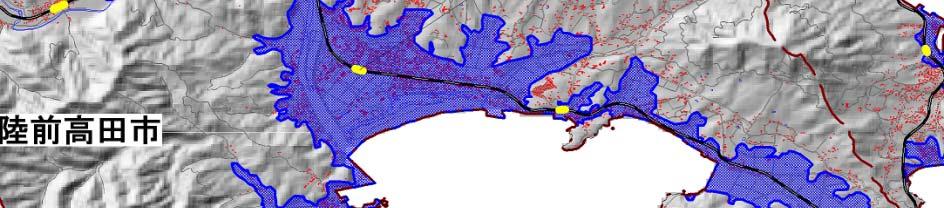


9 Height of Tsunami and Inundation Area Rikuzen-takada st. Ofunato city Rikuzen-takada city Kesen-numa city Taihaku ward Wakabayashi ward Natori city Shibata town Watari town Iwanuma city


10 Overview of Damages Prefecture House Damage Totally collapsed Partially destroyed d Missing and Dead Hokkaido Aomori Iwate 20,184 4,551 6,050 Miyagi 82, ,587 11,350 Yamagata Fukushima 19,157 58,603 2,008 Ibaraki 3,012 22, Tochigi i 265 2,048 4 Gunma Saitama Chiba 797 9, Tokyo Kanagawa Total 126, ,600 19,479


11 House Damages by the Great East Japan Earthquake Disaster
12 Category Building Residence, Shop, Office, Factory, Machinery etc. Lifeline Water supply, Gas, Electricity, Communication Infrastructure Economic Impact Estimated Loss (JPY trillion) The Great East Japan The Great Hanshin-Awaji Earthquake (2011) Earthquake (1995) by Cabinet Office, Gov. Of Japan River, Road, Port, Sewage, Airport Agriculture, Forestry and Fisheries 1.9 by National Land Agency Other Other 1.1 Total Total loss of the listed companies amounted to JPY 3.1 trillion One third of companies, which are listed in the first section of the Tokyo Stock Exchange and fiscal year ending March, posted a loss. About 20 companies posted a loss of over JPY 10 billion
13 Japan Worldwide Claims Paid for Major Disasters USD 1 = JPY 80 Category Event Name (Year) Total Loss Claims Paid (USD billion) (USD billion) personal insurance East Japan (2011) personal mutual aid Earthquake corporate 7.5 personal Hanshin-Awaji (1995) insurance personal mutual aid Typhoon MIREILLE (1991 No.19) Earthquake Northridge (1994) Katrina (2005) Hurricane Andrew (1992) Terrorism 9.11 WTC (2001) Cabinet Office, Government Of Japan, 2 National Land Agency, 3 National Research Institute for Earth Science and Disaster Prevention, 4 The General Insurance Association of Japan, 5 JA mutual Aid, 6 SwissRe, Sigma2011, No1
14 Lessons from the Tohoku Earthquake Complex wide-area disaster The limits of crisis management for complex wide-area disaster were exposed. Lack of Bird's-eye view for response to disaster Lack of comprehensive measures Elemental technologies were effective. (Earthquake-proof technology) Limits of elemental technologies that are optimized for the event in the expected. Lack of measures for unexpected events Needs for an integrated system for disaster mitigation Improvement of national power for disaster management and mitigation by reform of the social system Operational integration of disaster management and mitigation system as a service
of the Tohoku")


15 Comparison between the hazard maps and observed strong motions Comparison between the observed seismic intensities ( :K-NET, :KiK-net)of the Tohoku earthquake and seismic intensity distribution for 2% probability of exceedance in 50 years, which is one of the probabilistic seismic hazard map or less As you can see from this comparison, predicted ground motion level in the probabilistic seismic hazard map was clearly underestimated in Fukushima Prefecture and the northern part of Ibaraki Prefecture for the Tohoku earthquake. seismic intensity Seismic Intensity with 2% probability of exceedance in 50 year.
16 Flowchart of PSHA Modeling of seismic activity Evaluation of an EQ occurrence probability P(Ei) Probabilistic evaluation of an intensity level P(Yi > y Ei) Evaluation of probabilistic seismic hazard for each earthquake P(Yi > y)= P(Ei) P(Yi > y Ei) Evaluation of probabilistic seismic hazard for all earthquakes P(Y > y)=1-π[1- P(Yi > y)]


17 Evaluation of occurrence probability of earthquakes by ERCJ
18
19 Modeling of seismic activity in the Pacific plate before the 311 Tohoku earthquake M=8.0 6% Mu=7.0 M=7.5 >99%? M=7.7 81% Mu=7.0 Mu=7.2 Mu=7.5 M=7.4 7% M=7.0 99% M=8.2 5% Mt=8.2 20%? Mu=7.0 Mu=7.1 Mu=7.3 Mu=7.5 M for characteristic earthquakes Max M for background earthquakes
20 Seismic activity model for hazard assessment Earthquakes with specified dfault Earthquakes in major or other fault zones Earthquakes in subduction zones (Interplate or intraplate) Background earthquakes Inland earthquakes Earthquakes in subduction zones (Interplate or intraplate) In order to construct a probabilistic seismic activity model that encompasses the seismic activity of all possible earthquakes, it is necessary for the complement the long-term evaluation to use a different methodology from the traditional long-term evaluation.
21 Classification of uncertainty factors Aleatory Uncertainty Intrinsic uncertainty. It is represented by a random variable in the prediction model. Uncertainty caused by a limitation of model to explain phenomena. Uncertainty used to calculate a hazard curve. Epistemic Uncertainty Uncertainty due to a lack of knowledge and data. Uncertainty due to differences in judgment for modeling It is evaluated by using a logic tree. Represented by more than one hazard curve.
22 Problems that must be overcome for improvement of seismic i hazard assessment 1) Modeling of seismic activity with no oversight to low-probability earthquakes. 2) Preparation of strong ground motion maps considering low-probability earthquakes. 3) Development of methodology for selecting appropriate scenario earthquakes from probabilistic seismicity model. 4) Development of methodology for prediction i of strong ground motions for mega-thrust earthquakes.
23 Seismic activities in the Pacific plate No.1 No.2 (G-R law) It is necessary to promote proper modeling of background earthquakes that encompasses all earthquakes without longterm evaluation. For example it may be possible to evaluate the magnitude of For example, it may be possible to evaluate the magnitude of earthquakes from the area of the plate boundary that can be considered to cause earthquakes, and to assess the frequency of occurrence of earthquakes by using the Gutenberg-Richter formula that shows the relationship between the number of earthquakes and their magnitude.
24 Tentative modeling of seismic activity in the Pacific plate after the 311 Tohoku earthquake M=8.0 7% Mu=7.0 M=7.4 (55%)? Mu=8.0 or 8.2 M=7.9 0% M=7.4 14% M=7.0 95% M=8.2 5% Mt= % Mu=8.0 or 8.4 Mu=8.0 or 8.4 Mu=8.0 or 8.2 Mu=8.0 Mu=8.0 or 8.3? Mu=8.0 or 8.3 Intraplate Mu=7.5 or 8.2 M for characteristic earthquakes Max M for background earthquakes (Model 1 or Model 2)
25 PSHM taking into account the Tohoku earthquake (M9) Setting conditions for the Tohoku EQ Source area: Aftershock area The origin of the time:2011/1/1 Average interval: 600 years Latest activity period: 15th century Occurrence probability in 30 years: 15.4% G d ti ti Ground-motion equation: Si and Midorikawa(1999) (Saturated with Mw8.3)

")
26 PSHMs considering the Tohoku type earthquake (a) PSHM2011 (b) PSHM2011+TohokuM9
27 Strong-motion maps considering low-probability earthquakes 1,000 years 10,000 years 100,000 years Based on the averaged long-term seismic hazard assessment, evaluating strong-motion level for about 10, , years return period, we prepare the maps that show the distribution of strong-motion level, which represent effect of almost all of major earthquakes on active faults and subduction zone earthquakes with low-probability. Regarding the seismic hazard assessment for low probability, at present, it is insufficient to evaluate the uncertainty for low probability M8 class earthquakes and it is necessary to improve techniques for them.
28 The East Japan Earthquake and Other Major Earthquakes Massive Earthquake Model along Nankai Trough by the Central Disaster Prevention Council (2011) The Great East Japan Earthquake North Tokyo Bay The Great Kanto 1923 Genroku 1703 JMA Seismic Intensity for the 3 Coupled Earthquakes along Nankai-trough were evaluated by the Central Disaster Prevention Council (2003)
29 Historical and Assumed Earthquakes Event Name Estimated Population in the Area (million) 5+ SIJMA 6- SIJMA Property Loss (JPY trillion) Estimating Organization The Great Hanshin-Awaji Earthquake (1995) The Great East Japan Earthquake (2011) National Land Agency Cabinet Office, Government Of Japan 3 coupled Earthquakes along Central Disaster ~60 Prevention Council (2003) Nankai-trough (Tokai, To-Nankai, Nankai EQ) Tokyo Metropolitan Earthquake (North Tokyo Bay Earthquake) Central Disaster Prevention Council (2005)
30 Prepare for disaster risk by the intelligence Natural disaster Expertise Disaster prevention Resilient Society Experimental knowledge Knowledge on the region Knowledge on themselves I di id l i i d i l k l d h i Individuals can acquire expertise and experimental knowledge that exist in distributed and utilize them and sophisticate their own intelligence for disaster prevention.


31 災害危険度メータ _ 自宅の登録家族の登録自宅の耐震評価備蓄登録ファイル編集表示ツールヘルプ緊急地震速報なし台風や豪雨予想危険度 3 大丈夫? なし 災害危険度メータ _ 自宅の登録家族の登録自宅の耐震評価備蓄登録ファイル編集表示ツールヘルプ緊急地震速報なし台風や豪雨予想危険度 3 大丈夫? なし 災害危険度メータ _ 自宅の登録家族の登録自宅の耐震評価備蓄登録ファイル編集表示ツールヘルプ緊急地震速報なし台風や豪雨予想危険度 3 大丈夫? なし Disaster-Risk Information Platform (BOSAI-DRIP) Geospatial Information Interoperability of information Damage Assessment Hazard Map History and Record of Universities, Institutes Governments Disaster Companies, NPOs Interoperable Institutions and Services Information Environment AIU(Japanese ABC) for BOSAI DRIP A I U Disaster-Risk Management System for Local Community Clearinghouse for DRI DRMS for I DRMS for LC DRI for Earthquakes DRI for Volcanic Eruptions DRI for Floods DRI for Landslides DRI for Heavy Snow and Ice Disaster-Risk Evaluation System DRMS for I Disaster-Risk Management System for Individual DRMS for LC Utiliz zation of informatio on Ad dvanceme ent of info ormation
32 Thank you for attention.
National Seismic Hazard Maps for Japan and an integrated system for sharing information, J-SHIS
 National Seismic Hazard Maps for Japan and an integrated system for sharing information, J-SHIS H. Fujiwara, N.Morikawa, K. XS. Hao National Research Institute for Earth Science and Disaster Resilience
SEISMIC HAZARD ASSESSMENT FOR JAPAN AFTER THE 2011 TOHOKU-OKI MEGA-THRUST EARTHQUAKE (Mw9.0)
") Proceedings of the International Symposium on Engineering Lessons Learned from the 2011 Great East Japan Earthquake, March 1-4, 2012, Tokyo, Japan SEISMIC HAZARD ASSESSMENT FOR JAPAN AFTER THE 2011 TOHOKU-OKI
Proceedings of the International Symposium on Engineering Lessons Learned from the 2011 Great East Japan Earthquake, March 1-4, 2012, Tokyo, Japan SEISMIC HAZARD ASSESSMENT FOR JAPAN AFTER THE 2011 TOHOKU-OKI
Japan Seismic Hazard Information Station
 Japan Seismic Hazard Information Station (J-SHIS) Hiroyuki Fujiwara National Research Institute for Earth Science and Disaster Prevention (NIED) Background of the Project Headquarters for Earthquake Research
中村洋光 Hiromitsu Nakamura 防災科学技術研究所 National Research Institute for Earth Science and Disaster Prevention, Japan (NIED) Outline
 Outline") Earthquake Early Warning in Japan 中村洋光 Hiromitsu Nakamura 防災科学技術研究所 National Research Institute for Earth Science and Disaster Prevention, Japan (NIED) Outline Overview of the earthquake early warning
Earthquake Early Warning in Japan 中村洋光 Hiromitsu Nakamura 防災科学技術研究所 National Research Institute for Earth Science and Disaster Prevention, Japan (NIED) Outline Overview of the earthquake early warning
REPORT ON THE TOHOKU AREA PASIFIC OFFSHORE EARTHQUAKE
 REPORT ON THE TOHOKU AREA PASIFIC OFFSHORE EARTHQUAKE GENERAL PERSPECTIVE The Highest Magnitude Ever Recorded The 2011 off the Pacific Coast of Tohoku Earthquake (hereafter, the 2011 Tohoku- Pacific Earthquake
KNOWLEDGE NOTE 5-1. Risk Assessment and Hazard Mapping. CLUSTER 5: Hazard and Risk Information and Decision Making. Public Disclosure Authorized
 Public Disclosure Authorized Public Disclosure Authorized Public Disclosure Authorized Public Disclosure Authorized KNOWLEDGE NOTE 5-1 CLUSTER 5: Hazard and Risk Information and Decision Making Risk Assessment
Estimation of extended source area from vertical PGA saturation during a great earthquake for upgrading the EEW system
 Estimation of extended source area from vertical PGA saturation during a great for upgrading the EEW system S. Kurahashi & K. Irikura Aichi Institute of Technology SUMMARY: The present JMA Earthquake Early
STRONG MOTION RECORDS FROM THE 2011 OFF THE PACIFIC COAST OF TOHOKU EARTHQUAKE
 Proceedings of the International Symposium on Engineering Lessons Learned from the 211 Great East Japan Earthquake, March 1-4, 212, Tokyo, Japan STRONG MOTION RECORDS FROM THE 211 OFF THE PACIFIC COAST
2011/3/11 14:46, Depth 24km, M9.0 (JMA)
") Off the Pacific Coast of Tohoku earthquake, Strong Ground Motion /3/ 4:46, Depth 4km, M9. (JMA) Peak Ground Acceleration (surface) Peak Ground Velocity (surface) 45 45 4 4 PGA [gal].. 5... 5... 5....5.
Off the Pacific Coast of Tohoku earthquake, Strong Ground Motion /3/ 4:46, Depth 4km, M9. (JMA) Peak Ground Acceleration (surface) Peak Ground Velocity (surface) 45 45 4 4 PGA [gal].. 5... 5... 5....5.
Seismic Activity and Crustal Deformation after the 2011 Off the Pacific Coast of Tohoku Earthquake
 J-RAPID Symposium March 6-7, 2013 Seismic Activity and Crustal Deformation after the 2011 Off the Pacific Coast of Tohoku Earthquake Y. Honkura Tokyo Institute of Technology Japan Science and Technology
THE 2011 TOHOKU EARTHQUAKE IN JAPAN. VSU Lyuben Karavelov, Sofia, Bulgaria. Key words: Tohoku earthquake, strong ground motion, damage
 THE 2011 TOHOKU EARTHQUAKE IN JAPAN Radan Ivanov 1 VSU Lyuben Karavelov, Sofia, Bulgaria Abstract: This earthquake which occurred on March 11, 2011, had a magnitude of 9.0, which places it as the fourth
Tohoku-oki event: Tectonic setting
 Tohoku-oki event: Tectonic setting This earthquake was the result of thrust faulting along or near the convergent plate boundary where the Pacific Plate subducts beneath Japan. This map also shows the
Study of the liquefaction phenomenon due to an earthquake: case study of Urayasu city
 Disaster Management and Human Health Risk III 311 Study of the liquefaction phenomenon due to an earthquake: case study of Urayasu city S. Kamao 1, M. Takezawa 1, K. Yamada 1, S. Jinno 1, T. Shinoda 1
10th International Workshop on Seismic Microzoning and Risk Reduction September 25, 2013,Tokyo, Japan
 1th International Workshop on Seismic Microzoning and Risk Reduction September 25, 213,Tokyo, Japan National Graduate Institute for Policy Studies (GRIPS), Roppongi, Tokyo Some features of strong ground
JMA Tsunami Warning Services. Tomoaki OZAKI Senior Coordinator for Tsunami Forecast Modeling Japan Meteorological Agency
 JMA Tsunami Warning Services Tomoaki OZAKI Senior Coordinator for Tsunami Forecast Modeling Japan Meteorological Agency Organization Chart of the Government of Japan Cabinet Office Diet Ministry of Internal
Estimation of Damage Ratios of Wooden Houses and Water Distribution Pipelines in an Earthquake Scenario for the Tokyo Metropolitan Region
 The 2011 World Congress on Advances in Structural Engineering and Mechanics (ASEM'11 + ) Seoul, Korea, 18-22 September, 2011 Estimation of Damage Ratios of Wooden Houses and Water Distribution Pipelines
Earthquake Source. Kazuki Koketsu. Special Session: Great East Japan (Tohoku) Earthquake. Earthquake Research Institute, University of Tokyo
 Earthquake. Earthquake Research Institute, University of Tokyo") 2012/9/24 17:20-17:35 WCEE SS24.4 Special Session: Great East Japan (Tohoku) Earthquake Earthquake Source Kazuki Koketsu Earthquake Research Institute, University of Tokyo 1 Names and features of the earthquake
2012/9/24 17:20-17:35 WCEE SS24.4 Special Session: Great East Japan (Tohoku) Earthquake Earthquake Source Kazuki Koketsu Earthquake Research Institute, University of Tokyo 1 Names and features of the earthquake
A Study on the Risk Assessment of Emergency Supplies. Transportation Routes Considering Scenario Earthquakes
 ORIGINAL ARTICLE A Study on the Risk Assessment of Emergency Supplies Transportation s Considering Scenario Earthquakes Kazuaki Torisawa 1, Harumi Yashiro 2, Sei ichiro Fukushima 3*, Satoshi Kina 4 1 Kajima
Disclaimer. This report was compiled by an ADRC visiting researcher (VR) from ADRC member countries.
 from ADRC member countries.") Disclaimer This report was compiled by an ADRC visiting researcher (VR) from ADRC member countries. The views expressed in the report do not necessarily reflect the views of the ADRC. The boundaries and
Disclaimer This report was compiled by an ADRC visiting researcher (VR) from ADRC member countries. The views expressed in the report do not necessarily reflect the views of the ADRC. The boundaries and
PROBABILISTIC LIQUEFACTION HAZARD ANALYSIS IN JAPAN
 SECED 2015 Conference: Earthquake Risk and Engineering towards a Resilient World 9-10 July 2015, Cambridge UK PROBABILISTIC LIQUEFACTION HAZARD ANALYSIS IN JAPAN Tetsushi KURITA 1 and Sei ichiro FUKUSHIMA
Uncertainty in the assessment of seismic hazard
 The 3rd annual meeting of the seismic hazard assessment for the next generation map China-Japan-Korea cooperative program June 17 21, 2013, in Sendai, Japan Uncertainty in the assessment of seismic hazard
Advanced School on Direct and Inverse Problems of Seismology
 2167-17 Advanced School on Direct and Inverse Problems of Seismology 27 September - 8 October, 2010 Achievements of strong motion seismology and its future directions Kojiro Irikura Kyoto University Japan
Some Problems Related to Empirical Predictions of Strong Motion
 Bull. Earthq. Res. Inst. Univ. Tokyo Vol. 2+,**0 pp.,/-,/2 Some Problems Related to Empirical Predictions of Strong Motion Saburoh Midorikawa + * + Center for Urban Earthquake Engineering, Tokyo Institute
- Information before strong ground motion -
 -Earthquake Early Warning - Information before strong ground motion - Mitsuyuki HOSHIBA Japan Meteorological Agency January 12, 2007 1 Distribution of Earthquakes Causing Tsunami (1896~2004) in Japan Distribution
4-3-1 Earthquake and Tsunami Countermeasures of Tokyo s
 4-3-1 Earthquake and Tsunami Countermeasures of Tokyo s Sewerage Masahiro Hikino* and Gaku Sato** *Planning Section, Planning and Coordinating Division, Bureau of Sewerage, Tokyo Metropolitan Government
Strong ground motions from the 2011 off-the Pacific-Coast-of-Tohoku, Japan (Mw=9.0) earthquake obtained from a dense nationwide seismic network
 earthquake obtained from a dense nationwide seismic network") Landslides (2011) 8:333 338 DOI 10.1007/s10346-011-0279-3 Received: 10 June 2011 Accepted: 5 July 2011 Published online: 23 July 2011 The Author(s) 2011. This article is published with open access at Springerlink.com
Landslides (2011) 8:333 338 DOI 10.1007/s10346-011-0279-3 Received: 10 June 2011 Accepted: 5 July 2011 Published online: 23 July 2011 The Author(s) 2011. This article is published with open access at Springerlink.com
The great earthquakes that have shaped Japan 日本に大きな影響を与えた地震
 The great earthquakes that have shaped Japan 日本に大きな影響を与えた地震 Brian Kennett, Research School of Earth Sciences, ANU Takashi Furumura Earthquake Research Institute, University of Tokyo Japan tectonic plates
apanese Nationwide Earthquake and Tsunami Observation Network Operated by NIED
 APEC Workshop on Application of Big Data and Open Data@Taipei Garden Hotel (2015/10/29-30) apanese Nationwide Earthquake and Tsunami Observation Network Operated by NIED Shin Aoi National Research Institute
Quantitative Assessment of Epistemic Uncertainties in Tsunami Hazard Effects on Building Risk Assessments
 geosciences Article Quantitative Assessment of Epistemic Uncertainties in Tsunami Hazard Effects on Building Risk Assessments Yo Fukutani 1, * ID, Anawat Suppasri 2 Fumihiko Imamura 2 1 College of Science
4 Associate Professor, DPRI, Kyoto University, Uji, Japan
 Proceedings of the International Symposium on Engineering Lessons Learned from the 2 Great East Japan Earthquake, March -4, 22, Tokyo, Japan STRONG MOTION ESTIMATION AT THE ELEVATED BRIDGES OF THE TOHOKU
Shigeo Ochi 1, Mao Suzuoki 2
 The lessons of the Great East Japan Earthquake 2011 and the countermeasures against earthquakes and tsunami in future- Fundamental Concepts behind Future Tsunami Disaster Prevention by Shigeo Ochi 1, Mao
APPLICATON OF SEAMLESS SIMULATION OF SEISMIC RESPONSE ANALYSIS AND HIGH RESOLUTION TSUNAMI SIMULATION TO COASTAL AREA OF SENDAI
 Proceedings of the International Symposium on Engineering Lessons Learned from the 2011 Great East Japan Earthquake, March 1-4, 2012, Tokyo, Japan APPLICATON OF SEAMLESS SIMULATION OF SEISMIC RESPONSE
Earthquakes and Tsunamis
 Earthquakes and Tsunamis Kenji Satake Earthquake Research Institute University of Tokyo 1 Part I 2011 Tohoku earthquake and tsunami 2 Fukushima Dai ichi NPP accident Earthquake ground motion Reactors automatically
3D Seismic Hazard and Risk Maps for Earthquake Awareness of Citizens with Aids of GIS and Remote Sensing Technologies
 3D Seismic Hazard and Risk Maps for Earthquake Awareness of Citizens with Aids of GIS and Remote Sensing Technologies Saburoh Midorikawa Tokyo Institute of Technology In Japan, seismic hazard and risk
Analysis of Ignitions Following 2011 Tohoku Earthquake Using Kawasumi Model DRAFT
 Analysis of Ignitions Following 211 Tohoku Earthquake Using Kawasumi Model KEISUKE HIMOTO 1, MASUMI YAMADA 1, and TOMOAKI NISHINO 2 1 Disaster Prevention Research Institute, Kyoto University Gokasho, Uji,
PREDICTION OF AVERAGE SHEAR-WAVE VELOCITY FOR GROUND SHAKING MAPPING USING THE DIGITAL NATIONAL LAND INFORMATION OF JAPAN
 th World Conference on Earthquake Engineering Vancouver, B.C., Canada August -6, 00 Paper No. 07 PREDICTION OF AVERAGE SHEAR-WAVE VELOCITY FOR GROUND SHAKING MAPPING USING THE DIGITAL NATIONAL LAND INFORMATION
Simulated Earthquake Ground Motion for Structural Design"
 14 th U.S.-Japan Workshop on the Improvement of Building Structural Design and Construction Practices Simulated Earthquake Ground Motion for Structural Design" Satoru Nagase Structural Engineering Section,
Japan disaster Mitigation and prevention information XML format (JMX) is in operation! 6 Apr 2011 Yoshiaki SUGIYAMA Planning Division, JMA
 is in operation! 6 Apr 2011 Yoshiaki SUGIYAMA Planning Division, JMA") Japan disaster Mitigation and prevention information XML format (JMX) is in operation! 6 Apr 2011 Yoshiaki SUGIYAMA Planning Division, JMA First of All The 2011 off the Pacific coast of Tohoku Earthquake
Japan disaster Mitigation and prevention information XML format (JMX) is in operation! 6 Apr 2011 Yoshiaki SUGIYAMA Planning Division, JMA First of All The 2011 off the Pacific coast of Tohoku Earthquake
Preliminary Analysis for Characteristics of Strong Ground Motion from Gigantic Earthquakes
 Preliminary Analysis for Characteristics of Strong Ground Motion from Gigantic Earthquakes S. Midorikawa, H. Miura Interdisciplinary Graduate School of Science & Engineering, Tokyo Institute of Technology,
Basic Analysis on Building Damages by Tsunami due to The 2011 Great East Japan Earthquake Disaster Using GIS
 Basic Analysis on Building Damages by Tsunami due to The 2011 Great East Japan Earthquake Disaster Using GIS Kunihiro Amakuni Pacific Consultants Co. Ltd., Tokyo, Japan Naoto Terazono, Toshio Yamamoto&
PROBABILISTIC SEISMIC HAZARD MAPS AT GROUND SURFACE IN JAPAN BASED ON SITE EFFECTS ESTIMATED FROM OBSERVED STRONG-MOTION RECORDS
 13 th World Conference on Earthquake Engineering Vancouver, B.C., Canada August 1-6, 2004 Paper No. 3488 PROBABILISTIC SEISMIC HAZARD MAPS AT GROUND SURFACE IN JAPAN BASED ON SITE EFFECTS ESTIMATED FROM
The Restoration Process from the Great East Japan Earthquake, and Perspectives for the Sustainable Society by Creating Cultural Landscapes
 Session 3 Restoration from the Huge Natural Disasters, and Creating Cultural Landscapes for the Sustainable Society The Restoration Process from the Great East Japan Earthquake, and Perspectives for the
CHARACTERISTICS OF STRONG GROUND MOTION FROM THE 2011 GIGANTIC TOHOKU, JAPAN EARTHQUAKE
 Paper No. M-4 CHARACTERISTICS OF STRONG GROUND MOTION FROM THE 2011 GIGANTIC TOHOKU, JAPAN EARTHQUAKE Saburoh MIDORIKAWA 1, Hiroyuki MIURA 2 and Tomohiro ATSUMI 3 SUMMARY The 2011 Tohoku earthquake (Mw9.0)
Coseismic slip model
 Figure 3 - Preliminary highly smoothed model of coseismic slip for the 11 March UCL Institute for Risk & Disaster Reduction Magnitude 9.0 (JMA scale) earthquake Occurred at 02:46:23 pm local time near
Individual Self-help Housing Reconstruction with Relocation: Transformation of Built Environment after the Great East Japan Earthquake
 Individual Self-help Housing Reconstruction with Relocation: Transformation of Built Environment after the Great East Japan Earthquake Tamiyo Kondo, Kobe University tamiyok@people.kobe-u.ac.jp Yuka Karatani,
Forecasting Future Earthquakes from Tsunami Deposits and Simulation
 Forecasting Future Earthquakes from Tsunami Deposits and Simulation Kenji Satake Earthquake Research Institute The University of Tokyo satake@eri.u-tokyo.ac.jp Contents 1. Earthquake Recurrence and Forecast
Data Sharing at the National Research Institute for Earth Science and Disaster Resilience
 Data Sharing at the National Research Institute for Earth Science and Disaster Resilience Katsuhiko SHIOMI Network Center for Earthquake, Tsunami and Volcano, NIED 2017.12.05 International workshop on
Pacific Catastrophe Risk Assessment And Financing Initiative
 Pacific Catastrophe Risk Assessment And Financing Initiative TIMOR-LESTE September Timor-Leste is expected to incur, on average, 5.9 million USD per year in losses due to earthquakes and tropical cyclones.
New Seismic Activity Model of Large Earthquakes along Nankai Trough for Probabilistic Seismic Hazard Maps
 New Seismic Activity Model of Large Earthquakes along Nankai Trough for Probabilistic Seismic Hazard Maps Toshihiko Okumura (Shimizu Corp.) Hiroyuki Fujiwara (NIED) Plate Tectonics around Japan Pacific
JMA Tsunami Warning Services. Takeshi KOIZUMI Senior Coordinator for International Earthquake and Tsunami Information Japan Meteorological Agency
 JMA Tsunami Warning Services Takeshi KOIZUMI Senior Coordinator for International Earthquake and Tsunami Information Japan Meteorological Agency Tectonic Setting of Japan (Headquarters for Earthquake Research
Investigation of mechanisms causing ground motion and tsunami due to the 2011 Tohoku Earthquake at Nuclear Power Plant sites
 Investigation of mechanisms causing ground motion and tsunami due to the 211 Tohoku Earthquake at Nuclear Power Plant sites Hideharu Sugino, Yoko Iwabuchi, Katsumi Ebisawa Japan Nuclear Energy Safety Organization
Pacific Catastrophe Risk Assessment And Financing Initiative
 Pacific Catastrophe Risk Assessment And Financing Initiative PALAU September is expected to incur, on average,.7 million USD per year in losses due to earthquakes and tropical cyclones. In the next 5 years,
ACTIVITIES OF THE HEADQUARTERS FOR EARTHQUAKE RESEARCH PROMOTION
 Journal of Japan Association for Earthquake Engineering, Vol.4, No.3 (Special Issue), 2004 ACTIVITIES OF THE HEADQUARTERS FOR EARTHQUAKE RESEARCH PROMOTION Sadanori HIGASHI 1 1 Member of JAEE, Earthquake
Probabilistic Tsunami Hazard Analysis. Hong Kie Thio AECOM, Los Angeles
 Probabilistic Tsunami Hazard Analysis Hong Kie Thio AECOM, Los Angeles May 18, 2015 Overview Introduction Types of hazard analysis Similarities and differences to seismic hazard Methodology Elements o
EVALUATION OF SITE AMPLIFICATION AND PHASE EFFECTS IN KUSHIMOTO TOWN, WAKAYAMA PREFECTURE, JAPAN
 EVALUATION OF SITE AMPLIFICATION AND PHASE EFFECTS IN KUSHIMOTO TOWN, WAKAYAMA PREFECTURE, JAPAN Yoshiya HATA 1 and Masayuki YAMADA 2 INTRODUCTION The occurrence of the 211 Tohoku earthquake (M W 9.) along
GROUND MOTION SPECTRAL INTENSITY PREDICTION WITH STOCHASTIC GREEN S FUNCTION METHOD FOR HYPOTHETICAL GREAT EARTHQUAKES ALONG THE NANKAI TROUGH, JAPAN
 GROUND MOTION SPECTRAL INTENSITY PREDICTION WITH STOCHASTIC GREEN S FUNCTION METHOD FOR HYPOTHETICAL GREAT EARTHQUAKES ALONG THE NANKAI TROUGH, JAPAN Masayuki YOSHIMI 1, Yasuto KUWAHARA 2, Masayuki YAMADA
REAL-TIME TSUNAMI INUNDATION PREDICTION USING OFFSHORE TSUNAMI OBSERVATION. Daisuke TATSUMI 1 and Takashi TOMITA 1
 REAL-TIME TSUNAMI INUNDATION PREDICTION USING OFFSHORE TSUNAMI OBSERVATION Daisuke TATSUMI and Takashi TOMITA The previous real-time tsunami prediction based on the inversion method and the linear superposition
Final Presentation on Disaster Risk Management in Japan. Through ADRC V. R Programme. Main Findings and Action Plan:
 Final Presentation on Disaster Risk Management in Japan Through ADRC V. R Programme Main Findings and Action Plan: Problem/Hazard and Disaster in Japan Good Practiced on Disaster Risk Management in Japan
Xiang Wen, & Takahashi Toru Chiba University, Chiba City, Japan. Katada Masaki Kyoto University, Kyoto, Japan
 Damage Scenario and Its Reduction for Nishi-Chiba Campus, Chiba University due to Tokai, Tonankai, Nankai Coupled Earthquake and The Capital, Tokyo Inland Earthquake Xiang Wen, & Takahashi Toru Chiba University,
Outline of Sediment Disaster Early Warning in Japan
 JICA training(disaster Management for Landslide and Sediment-related Disaster) Outline of Sediment Disaster Early Warning in Japan December 2, 2014 Masaru KUNITOMO National Institute for Land and Infrastructure
Source region of the earthquake
 Disasters of port facilities due to 2011 Great East Japan Earthquake Yoshiaki Kikuchi Port & Airport Research Institute Contents Outline of the earthquake Measured Tsunami height Breakwater disasters by
Pacific Catastrophe Risk Assessment And Financing Initiative
 Pacific Catastrophe Risk Assessment And Financing Initiative VANUATU September 211 Country Risk Profile: VANUATU is expected to incur, on average, 48 million USD per year in losses due to earthquakes and
Introduction to Multi-hazard Risk-based Early Warning System in Japan
 Introduction to Multi-hazard Risk-based Early Warning System in Japan Yasuo SEKITA (Mr) Director-General, Forecast Department Japan Meteorological Agency (JMA) Natural Disasters in Asia Source: Disasters
Effects of Surface Geology on Seismic Motion
 4 th IASPEI / IAEE International Symposium: Effects of Surface Geology on Seismic Motion August 23 26, 2011 University of California Santa Barbara STRONG MOTION CHARACTERISTICS AND THEIR DAMAGE IMPACT
Japanese Earthquake Researches for Seismic and Tsunami Disaster Resilience
 Japanese Earthquake Researches for Seismic and Tsunami Disaster Resilience Naoshi Hirata Earthquake Research Institute, the University of Tokyo Chair of Earthquake Research Committee, the Headquarters
Site specific seismic hazard assessment a case study of Guanyin offshore wind farm 場址特定地震危害度評估 - 以觀音離岸風力發電廠為例
 Site specific seismic hazard assessment a case study of Guanyin offshore wind farm 場址特定地震危害度評估 - 以觀音離岸風力發電廠為例 Supervisor : Dr. Chyi-Tyi Lee and Dr. Kuo-Fong Ma Speaker : Jia-Cian Gao 2018/04/26 1 1. A
気象研究所技術報告第 77 号 2017 第 1 章巨大地震の規模等の把握 1.1 様々な早期規模推定手法 本項の論文は, 著者からの転載許可を受けて掲載している (Katsumata, A., S. Aoki, Y. Yoshida, H. Ueno and T. Yokota, 2012: Ra
 第 1 章巨大地震の規模等の把握 1.1 様々な早期規模推定手法 本項の論文は, 著者からの転載許可を受けて掲載している (Katsumata, A., S. Aoki, Y. Yoshida, H. Ueno and T. Yokota, 2012: Rapid source parameter estimation of great earthquakes for tsunami warning,
Challenges for Forecasting Size and Time for Future Great Earthquakes in Subduction Zone
 Challenges for Forecasting Size and Time for Future Great Earthquakes in Subduction Zone Kenji Satake Earthquake Research Institute, University of Tokyo 1 Outline 1. The 2011 Tohoku Earthquake 2. Long-term
 Title Preliminary report of the 2011 off Earthquake Author(s) Takewaki, Izuru Citation Journal of Zhejiang University SCIE 327-334 Issue Date 2011-05 URL http://hdl.handle.net/2433/159442 RightThe final
The impact of the 2011 off the Pacific coast of Tohoku Earthquake on Tsukuba 32-m station
 7th IVS General Meeting Madrid, Spain March 4-9 2012 The impact of the 2011 off the Pacific coast of Tohoku Earthquake on Tsukuba 32-m station SHINOBU KURIHARA K. Kokado, J. Kuroda, M. Ishihara and R.
High Acceleration Motions generated from the 2011 Pacific coast off Tohoku, Japan Earthquake
 High Acceleration Motions generated from the 2011 Pacific coast off Tohoku, Japan Earthquake K. Irikura Disaster Prevention Research Center, Aichi Institute of Technology, Japan S. Kurahashi Disaster Prevention
Source modeling of hypothetical Tokai-Tonankai-Nankai, Japan, earthquake and strong ground motion simulation using the empirical Green s functions
 Source modeling of hypothetical Tokai-Tonankai-Nankai, Japan, earthquake and strong ground motion simulation using the empirical Green s functions Y. Ishii & K. Dan Ohsaki Research Institute, Inc., Tokyo
A Prototype of Strong Ground Motion Prediction Procedure for Intraslab Earthquake based on the Characterized Source Model
 A Prototype of Strong Ground Motion Prediction Procedure for Intraslab Earthquake based on the Characterized Source Model T. Iwata, K. Asano & H. Sekiguchi Disaster Prevention Research Institute, Kyoto
Fujinuma Dam Performance during 2011 Tohoku Earthquake, Japan and Failure Mechanism by FEM
 Fujinuma Dam Performance during 2011 Tohoku Earthquake, Japan and Failure Mechanism by FEM Mahdavian Abbas Powue and Water University of Technology, Tehran, Iran Shiro Takada Tehran University, Tehran,
The 2011 Tohoku earthquake and dams
 The 2011 Tohoku earthquake and dams N. Matsumoto & T. Sasaki Japan Dam Engineering Center, Japan T. Ohmachi Tokyo Institute of Technology, Japan ABSTRACT: The magnitude 9.0 Tohoku earthquake occurred on
Pacific Catastrophe Risk Assessment And Financing Initiative
 Pacific Catastrophe Risk Assessment And Financing Initiative TUVALU is expected to incur, on average,. million USD per year in losses due to earthquakes and tropical cyclones. In the next 5 years, has
Initiative. Country Risk Profile: papua new guinea. Better Risk Information for Smarter Investments PAPUA NEW GUINEA.
 Pacific Catastrophe Risk Assessment And Financing Initiative PAPUA NEW GUINEA September 211 Country Risk Profile: papua new is expected to incur, on average, 85 million USD per year in losses due to earthquakes
Relationship between Building Damage Ratios and Ground Motion Characteristics during the 2011 Tohoku Earthquake
 Journal of Natural Disaster Science, Volume 34, Number 1, 2012, pp59-78 Relationship between Building Damage Ratios and Ground Motion Characteristics during the 2011 Tohoku Earthquake Hao WU* Kazuaki MASAKI**
Risk-based land use and spatial planning
 Risk-based land use and spatial planning Miho OHARA International Centre for Water Hazards and Risk Management (ICHARM) Public Works Research Institute PWRI), Japan Under the auspices of UNESCO Introduction
Disaster Risk Assessment: Opportunities for GIS and data management with Open DRI
 Disaster Risk Assessment: Opportunities for GIS and data management with Open DRI Jacob Opadeyi Department of Geomatics Engineering and Land Management, The University of the West Indies, St. Augustine,
Overview of Seismic PHSA Approaches with Emphasis on the Management of Uncertainties
 H4.SMR/1645-29 "2nd Workshop on Earthquake Engineering for Nuclear Facilities: Uncertainties in Seismic Hazard" 14-25 February 2005 Overview of Seismic PHSA Approaches with Emphasis on the Management of
with tsunami simulation Author(s) Shishikura, Masanobu; Sawai, Y.; Na Symposium on Backwards Problem in G
 Shishikura, Masanobu; Sawai, Y.; Na Symposium on Backwards Problem in G") Reconstruction of the 869 Jogan Ear Titlethe 2011 Tohoku earthquake, by geol with tsunami simulation Author(s) Shishikura, Masanobu; Sawai, Y.; Na Proceeding of TC302 Symposium Osaka Citation Symposium
Reconstruction of the 869 Jogan Ear Titlethe 2011 Tohoku earthquake, by geol with tsunami simulation Author(s) Shishikura, Masanobu; Sawai, Y.; Na Proceeding of TC302 Symposium Osaka Citation Symposium
Actual practices of seismic strong motion estimation at NPP sites
 ANSN Regional Workshop on Site Selection and Evaluation for Nuclear Power Plants June 2010, Hanoi Vietnam IAEA/ISSC Actual practices of seismic strong motion estimation at NPP sites Yoshi. FUKUSHIMA (JNES)
Changes in the Level of Convenience of the Iwate Prefecture Temporary Housing Complexes Constructed after the 2011 Tohoku Earthquake
 Changes in the Level of Convenience of the Iwate Prefecture Temporary Housing Complexes Constructed after the 2011 Tohoku Earthquake Shin-ichi Konno, Risa Shibutani, and Noriaki Endo Abstract We evaluated
I. Locations of Earthquakes. Announcements. Earthquakes Ch. 5. video Northridge, California earthquake, lecture on Chapter 5 Earthquakes!
 51-100-21 Environmental Geology Summer 2006 Tuesday & Thursday 6-9:20 p.m. Dr. Beyer Earthquakes Ch. 5 I. Locations of Earthquakes II. Earthquake Processes III. Effects of Earthquakes IV. Earthquake Risk
What Are Disasters? The Rescue Kids Trio!
 The Rescue Kids Trio! What Are Disasters? This manual was made possible through funding by the Council of Local Authorities for International Relations. Disasters and emergency preparedness Emergency preparedness
EARTHQUAKE HAZARD ASSESSMENT IN KAZAKHSTAN
 EARTHQUAKE HAZARD ASSESSMENT IN KAZAKHSTAN Dr Ilaria Mosca 1 and Dr Natalya Silacheva 2 1 British Geological Survey, Edinburgh (UK) imosca@nerc.ac.uk 2 Institute of Seismology, Almaty (Kazakhstan) silacheva_nat@mail.ru
Frequency-dependent Strong Motion Duration Using Total Threshold Intervals of Velocity Response Envelope
 Proceedings of the Tenth Pacific Conference on Earthquake Engineering Building an Earthquake-Resilient Pacific 6-8 November 015, Sydney, Australia Frequency-dependent Strong Motion Duration Using Total
Preliminary report of the 2011 off the Pacific coast of Tohoku Earthquake *
 Takewaki / J Zhejiang Univ-Sci A (Appl Phys & Eng) 211 12(5):327-334 327 Journal of Zhejiang University-SCIENCE A (Applied Physics & Engineering) ISSN 1673-565X (Print); ISSN 1862-1775 (Online) www.zju.edu.cn/jzus;
Recent Progress of Seismic Observation Networks in Japan
 Journal of Physics: Conference Series Recent Progress of Seismic Observation Networks in Japan To cite this article: Y Okada 2013 J. Phys.: Conf. Ser. 433 012039 Related content - Physical applications
PRELIMINARY STUDY OF GROUND MOTION CHARACTERISTICS IN FURUKAWA DISTRICT, JAPAN, BASED ON VERY DENSE SEISMIC-ARRAY-OBSERVATION
 Proceedings of the International Symposium on Engineering Lessons Learned from the 2011 Great East Japan Earthquake, March 1-4, 2012, Tokyo, Japan PRELIMINARY STUDY OF GROUND MOTION CHARACTERISTICS IN
Lessons Learned from Past Tsunamis Warning and Emergency Response
 UNESCO IOC CTIC US NOAA ITIC Regional Training Workshop on Strengthening Tsunami Warning and Emergency Response Standard Operating Procedures and the Development of the ICG/CARIBE-EWS PTWC New Enhanced
NGIAs' roles in successful disaster response
 The Second UN-GGIM-AP Plenary Meeting NGIAs' roles in successful disaster response Japan Teheran Iran 28 October 2013 Shin-ichi SAKABE, Director of International Affairs Division Geospatial Information
Three Fs of earthquakes: forces, faults, and friction. Slow accumulation and rapid release of elastic energy.
 Earthquake Machine Stick-slip: Elastic Rebound Theory Jerky motions on faults produce EQs Three Fs of earthquakes: forces, faults, and friction. Slow accumulation and rapid release of elastic energy. Three
Prevention Tsunami wall 10m high (breached by the tsunami due to land level falling by 3m)
") Plate margin Plates Causes Sendai, Japan Convergent plate margin Pacific and Eurasian Plates Convergent plate margin Sima (Pacific plate) moves towards the sial (Eurasian plate) Sima (Pacific plate) is
Plate margin Plates Causes Sendai, Japan Convergent plate margin Pacific and Eurasian Plates Convergent plate margin Sima (Pacific plate) moves towards the sial (Eurasian plate) Sima (Pacific plate) is
Borah Peak Earthquake HAZUS Scenario Project Executive Summary Idaho Bureau of Homeland Security Idaho Geological Survey Western States Seismic
 Borah Peak Earthquake HAZUS Scenario Project Executive Summary Idaho Bureau of Homeland Security Idaho Geological Survey Western States Seismic Policy Council 12/30/2008 The HAZUS-MH analysis of the Borah
ANALYSIS OF EVACUATION BEHAVIORS IN DIFFERENT AREAS BEFORE AND AFTER THE GREAT EAST JAPAN EARTHQUAKE
 Fifth International Conference on Geotechnique, Construction Materials and Environment, Osaka, Japan, Nov. 16-18, 2015, ISBN: 978-4-9905958-4-5 C3051 ANALYSIS OF EVACUATION BEHAVIORS IN DIFFERENT AREAS
RESIDENTIAL DAMAGE IN IBARAKI DURING THE GREAT EASTERN JAPAN EARTHQUAKE
 Proceedings of the International Symposium on Engineering Lessons Learned from the 2011 Great East Japan Earthquake, March 1-4, 2012, Tokyo, Japan RESIDENTIAL DAMAGE IN IBARAKI DURING THE GREAT EASTERN
RELATIONSHIP BETWEEN AGE OF GROUND AND LIQUEFACTION OCCURRENCE IN THE 2011 GREAT EAST JAPAN EARTHQUAKE
 Proceedings of the International Symposium on Engineering Lessons Learned from the 2011 Great East Japan Earthquake, March 1-4, 2012, Tokyo, Japan RELATIONSHIP BETWEEN AGE OF GROUND AND LIQUEFACTION OCCURRENCE
NATIONWIDE SITE AMPLIFICATION ZONATION STUDY USING JAPAN ENGINEERING GEOMORPHOLOGIC CLASSIFICATION MAP
 13 th World Conference on Earthquake Engineering Vancouver, B.C., Canada August 1-6, 24 Paper No. 1648 NATIONWIDE SITE AMPLIFICATION ZONATION STUDY USING JAPAN ENGINEERING GEOMORPHOLOGIC CLASSIFICATION