Characteristics of Mudstone in Complex Fluvial Sedimentary System in Bohai L Oilfield
|
|
|
- Allison Jennings
- 5 years ago
- Views:
Transcription
1 Earth Science Research; Vol. 7, No. 2; 2018 ISSN E-ISSN Published by Canadian Center of Science and Education Characteristics of Mudstone in Complex Fluvial Sedimentary System in Bohai L Oilfield Kai Huang 1, Chunsheng Shen 1, Kai Kang 1, Libing Wang 1, Zhongbo Xu 1 & Lin Li 1 1 Bohai Petroleum Research Institute, Tianjin Branch, CNOOC, Co., Ltd., China Correspondence: Huang Kai, Bohai Petroleum Research Institute, Tianjin Branch, CNOOC, Co., Ltd., China. E- mail: dr.superhou@163.com Received: April 2, 2018 Accepted: April 16, 2018 Online Published: July 9, 2018 doi: /esr.v7n2p79 URL: Abstract Bohai L oilfield develops a complex fluvial sedimentary system, which includes many types of fluvial sedimentary facies. Based on the coring well of oil field, the distribution characteristics of mudstone are analyzed, it is shown that the mudstone has similar internal structure and can be classified into four types according to its color: gray to grayish, variegated, brown to gray-brown and khaki, the assemblage has a large gray to grayish mudstone section, large gray to grayish mudstone intercalated thin layer sandstone, gray to grayish mudstone associated with variegated (brown) mudstone, grayish mudstone associated with lacustrine sand grain bedding sandstone, concomitant generation of large staggered bedding sandstone and grayish mudstone, mixed (gray-brown) mudstone associated with large staggered bedding sandstone, interaction between different colors of mudstone and sandstone and large interlaced sandstone intercalated with thin layer mudstone. The mudstone color is mainly gray and grayish, and very few oxidized mudstone is developed alone, which indicates that fluvial mudstone may be formed in the reductive environment in humid climate, and the fluvial mudstone in this area may be formed in the oxidizing environment, which is different from the general understanding of fluvial facies, the oxidation color is the result of the later transformation. Keywords: complex fluvial system, mudstone color, mudstone genesis, Bohai Bay Basin 1. Introduction It is generally considered that mudstone varies greatly in different backgrounds and can be used to indicate sedimentary environment. Such as in the reducing environment and deep water environment, there are differences in the color of mudstone, bedding and organic matter content, there are also differences in sonic time difference curve, density curve and even seismic, so that different sedimentary environments can be distinguished. However, in complex fluvial systems, mudstone characteristics are not obvious, so it is difficult to distinguish different sedimentary environments, especially different mudstones, which have similar sedimentary internal structure and composition, but have no obvious difference except color, so it's very difficult to identify the sedimentary environment. It is generally believed that the fluvial system is developed in the water environment, and the mudstone should be characterized by oxidation, such as brown, red and so on. At the same time, paleosols are often developed because of the exposure to the land environment. A large number of outcrop observations have also confirmed this understanding. However, the core observation of continuous coring section in L Oilfield shows that the fluvial sedimentary system is not so simple, and its interior may be composed of complex sedimentary systems by various environments, including fluvial facies, inter fluvial depressions, lakes, etc, a combination of delta and interfluvial flood plains, not just fluvial systems. The mudstone in this system may be different from our original understanding, it is deposited in a reductive environment, but it may eventually manifest itself in an oxidizing or reducing environment, which is controlled by the syngenic environment after its deposition, in different syngeneic environment performance for different characteristics. 2. Mudstone Characteristic Study of mudstones in the research area indicated, the mudstones in the complex fluvial system are different from the lacustrine mudstones or swamp facies mudstones, which are highlighted by the following characteristics: 2.1 Impure Argillaceous The mudstone looks rough on the whole, and the section is not tidiness and has no luster. Contains silt, sometimes 79
2 sand or gravel, with some mixed features. In general, the cementation is not tight, and loose parts are mostly powdery or irregular. 2.2 Massive Bedding Features Basically, it is not developed bedding for rapid depositing, mainly in massive. The internal heterogeneity is poor and basically has similar structural characteristics, indicating that the sedimentary environment is similar or identical. It may be a result of rapid sedimentation. In particular, some of the gravels in the sand-bearing or pebbly segments show dispersion, indicating rapid accumulation process. 2.3 Low Organic Matter Content The observation of its appearance indicates that it does not have obvious,residue of carbon-based nor does it develop a dense structure that is rich in dispersed organic mudstone. Judging from the results of its electrical measurements and interpretations, the differences between the sonic time difference and the density log curve of mudstone are not obvious, and it also suggests that the organic matter content is not very different. Oxide-colored mudstone apparently does not have a rich organic matter content, while mudstone with a reduced color does not have a significant difference from it, suggesting that it has a similarly low organic matter content. 2.4 Few Cuttings or Roots Structures In mudstone, there are basically no charcoal or plant root traces, suggesting that they were deposited in non-marsh or shore environments, and may be the result of rapid underwater sedimentation. The plants did not have time to grow, and there were not a large number of plants that were brought into the mudstone. The water power is weak and it does not have the ability to carry plant debris. 2.5 Rare Deformation Structure The mudstones are basically distributed continuously. Scoured boulders are rarely seen in contact with sandstones, and there are almost no deformed structures such as deformed or torn mudstones. These indicate that the bottom shape of the mudstone is relatively stable and may not have a gradient, and there is no comparison. The apparent need for rapid water release indicates the relative stability of its mudstone deposition environment. The mudstone structure in the study area has a small difference, but the color difference is obvious. Based on the color, it can be divided into four categories: The first type is gray to grayish. Such mudstones are dominated by grayish, which may develop in large sections or coexist with sandstone. The shades of color are different, but basically they all show the characteristics of reduced color, indicating that they are formed in the reducing environment and have not undergone the later reformation. The second type is brown to khaki mudstone. Such mudstones are structurally denser than the first types of mudstones, and may be the result of strong cementation. They exhibit blocky characteristics, and the internal colors are not very uniform, sometimes with patches of different colors. This type of mudstone and gray mudstone show a transitional contact pattern, which can be a continuous transition from gray to dark purple to brown, indicating that it may be formed by the later oxidation of grayish mudstone. The third type is khaki mudstone. It shows obvious characteristics of soil gasification, appears loose, sometimes presents a mixture of khaki and gray, sometimes shows a mixture of khaki and brown, and is a sign of ancient soil, indicating that it has undergone a long period of weathering and soiling. The fourth category is variegated mudstone. Mudstones are of mixed colors ranging from violet-brown to khaki, grayish to gray-brown, showing a transition between different types of environments, which is the result of incomplete changes in the original mudstone environment in the later period and direct evidence of late environmental changes. 3. The Combination Style of Mudstone 3.1 Large Set of Gray to Grayish Mudstone Section This type of mudstone exhibits large-scale continuous production characteristics. The thickness of a single layer is several meters. The thickest part of the coring well reaches nearly 10 meters, such as 6 wells meters. This section is a continuous mudstone section about 8 meters thick, in addition to individual parts of the color has changed, basically gray to grayish, of course, some changes in the color also appeared small differences in structure, such as the partial display of looser features, the other parts are relatively dense. Locally dispersed, khaki, porphyritic crumb exhibit weak post-modification. Another example is the 6 well meters well section, the upper part is relatively loose grayish, and the lower part is to show some light purple features with grayish- 80
3 based slightly oxidized transformation characteristics (Figure 1A). This grayish mudstone should be formed in shallow water environments that are stable for a long period of time. It is only during the flood season that muddy materials are carried along with the water, and there is usually less sediment supply. At the same time, it is basically not exposed to air, and oxidation color characteristics are rarely seen. 3.2 Large Sections of Gray to Grayish Mudstone Sandwich thin Layered Sandstone This shows a large section of grayish mudstones with small layers of parallel bedding or massive bedding sandstones. Mudstones and the surface of sandstones show abrupt contact, but mudstones are less likely to be cracked and no boulder clay is found (Figure 1E, 2A). The color of mudstone is changed, and above or below the sandstone, there may be changes in the purity and color of the mudstone as a result of deeper or shallower water bodies or changes in sediment supply. This type of combination is similar to the former type and is formed in a long-term stable shallow water environment. However, due to the relatively strong hydrodynamic forces, floodwaters carry sand into the water from time to time to form short-term thin sand deposits. 3.3 Grayish Mudstones Associated with Variegated (Brown) Mudstones The variegated (brown) mudstones are associated with the top or bottom, and the ratio of mudstones of different colors is also different. There may be a mixture of grayish mudstones with variegated mudstones, brown mudstones or khaki mudstones. The mixing ratio indicates the size of the layer to be modified, and the degree of color mixing reveals the strength of the transformation. The m of the 1D Figure shows a yellowish color, while the other parts are grayish, indicating that the sediment has undergone a deep soil transformation and the characteristics of the upper mudstone soil are relatively obvious. However, the formation of the mudstone is not a continuous exposure transformation. Affected intervals are relatively limited. In Figure 2C, the mixed color is different from the former, the mixed colors are mixed, and the mixed color layer is thick, but the mixed color oxidation degree is not very high, and may be related to the intermittent exposure and renovation of the mixed color for a long time. This transformation generally takes a long time, but the time for a single-stage transformation is not long, making the transformation not very serious and without the characteristics of soilization, but the large-scale mudstones are transformed by oxidation. During the transformation process, the degree of transformation of different intervals is different, and different parts of the original color are retained in different parts. Part of the m section of the Figure 2D was reconstructed obviously. It has certain characteristics of soilization, indicating that it has a relatively high degree of transformation, but it has also been slightly modified at the site of meters. The original sedimentary features have been preserved in other parts. 3.4 Grayish Mudstones Associated with Lake-Phase Sand-Grain Sandstone The m grayish mudstone in the Figure let 1F is associated with the upper layer of wave sand pattern, which indicates that the sediment has some lake energy and reveals the existence of the lake. 3.5 Large Interlaced Sandstones Associated with Grayish Mudstones The lower part of the Figure 2B is mudstone, and the upper part is a large cross-stratified sandstone. The upper part is a distributary channel or fluvial channel deposition, while the lower part of the mudstone is deposited in shallow water bays or depressions. There is a significant abrupt contact between the two, and there may be a scouring surface, but no mudstone is found, indicating that the sediment is under water. The volcanic mudstone does not have strong scouring effect, but is mainly a kind of filled sand filling effect. 3.6 Variegated (Grey-Brown) Mudstones Associated with Large Interlaced Sandstones The lower part of the Figure 1C is a large-scale cross-bedded sandstone, while the upper part is a brown mudstone reconstructed with a thin layer of grayish mudstone at the bottom of the mudstone. After the deposition, it was later exposed and reformed to form an oxidized mudstone section. 3.7 Mudstones of Different Colors Interact with Sandstone As shown in Figure 1G and 2E, mudstones of different colors form interactive deposits with sandstones. In the Figure 1G, the sandstone from the lower part transitions upwards into the shaly sandstone and mudstone, and then the oxidized mudstone finally turns into the earthy yellow mudstone with obvious soilization. Mudstone is obviously a different sediment in the third stage, and its formation process is also different. The top mudstone modification is obviously higher than the lower part. In the Figure 2E, the previously deposited mudstone was oxidized and soiled, and then converted to shallow muddy sedimentary sedimentary mudstone, which was then converted into a sand body with strong hydrodynamics and fluvial deposit environment. 3.8 Large Sets of Large Interlaced Sandstones with thin Layers of Mudstone This type of mudstone is a muddy deposit caused by the interruption of sand supply during fluvial sedimentation 81
4 and can be used as a sandwich in sandstone (Figure 2F, 2G). Mudstone contains a certain amount of sand, showing horizontal bedding features. From the color point of view, it is mainly grey, indicating that even in the fluvial environment, the original sedimentary mudstone may be a reduction color. 4. The Spatial Evolution Characteristics of Mudstone The observation of the core well shows that the development of mudstone has the following characteristics: Mudstone changes quickly. There are obvious changes in different horizons and between different locations in the same period. The change of mudstone is mainly reflected in the change of thickness and color, especially the change of color is particularly large. In the same interval or in different spatial positions of the same interval, the color of mudstone will change greatly, indicating the environment after deposition is not particularly stable, and the exposure is a common phenomenon. However, there are also differences in this exposure. Sometimes it is a continuous exposure for a long time, resulting in soil erosion. Sometimes it is only intermittent intermittent exposure. It causes mudstone to show oxidation color characteristics. The variegated or khaki mudstones rarely appear on their own, and are often associated with gray to grayish mudstones. The observation of Mudstone shows that the development of oxidized mudstone seldom occurs on their own. Even a large section of variegated mudstones are mixed with small grayish mudstones. This may indicate that the oxidation of the environment is based on reduced deposition, and there is no direct deposition of mudstone in oxidizing environment. For example, there are m mudstones in No. 6 wells with variegated mudstones and paleosol muds, but there are also multiple grayish mudstone sections in the middle. Although the grayish mudstone segments are mostly below 20 cm, they are indistinguishable from those of variegated mudstones and soil muds, suggesting the interval characteristics of sedimentation and exposure (Figure 3). The mudstone associated with small layered rocks or associated with thin sandstones is mostly grayish. There is little interaction between gray mudstone and small sandstone segments. The mudstone is mainly gray to grayish, rather than brownish or variegated oxidized color. The statistical results of mudstone sections observed on the core of the area indicate that the proportion of oxidized mudstones such as brown and variegated is low, and the thickness of a single section is not large. And mudstone is mainly composed of reduced mudstone. The total thickness of grayish mudstone in the 4 wells is 82.6 meters, accounting for 87% of the total; and the grayish rock in the 6 wells is 45 meters, accounting for 73%.The well 8 has 19.9 meters of grayish rock, accounting for 80% of the total, and the PL has 22.5 meters of grayish rock, accounting for 84% of the total. On the other hand, grayish mudstone also predominates in terms of the number of layers and the thickness of the monolayer (Table 1). Table 1. Development Characteristics of Mudstone with Different Colors Well Name Well 4 Well 6 Well 8 Well 3 The total length (m) Grayish Number of plies Maximum thickness of single layer (m) Average (m) Taupe Number of plies Maximum thickness of single layer (m) Average (m) Wheat Number of plies Maximum thickness of single layer (m) Average (m) Mottle Number of plies
5 Maximum thickness of single layer (m) Average (m) Discussion on Relationship between Mudstone Development and Sedimentary Environment In case of L oilfield, mudstone mainly reflects the reduced color of gray to grayish in the complex fluvial system. Although there are variegated mudstones and even soiled paleosol, they are not dominant. The assemble pattern of mudstone and distribution show that few mudstones of oxide color exist alone. They probably formed in the reducing environment, then syngenetic environment changed their original color, or the final color was changed by syngenetic environment. There is no trace of plant growth or deposition in the mudstone, which indicates that this kind of mudstone deposit is different from the fluvial bay environment where plant debris easily accumulates and environment with plant growth. The characteristics of this mudstone are obviously different from the fluvial environment which we recognize as characterized by exposure and soilization. It may indicate that the fluvial facies is not necessarily what we originally considered to be the product of the exposed environment, but it may be the interaction between the reducing environment and the exposed environment. And the mudstone deposits may also be mainly developed in low-lying areas or lakes, but not by fluvial flows over the arid fluvial plain. Perhaps the formation of mudstone in L oilfield is related to its location and climate. Humidity has a large number of small lakes and puddles and wetlands, which has a large number of local depocenter and small catchment area and fluvials are in the low-lying land. There are a large number of lakes and wetlands between fluvials, but only the local outcropped area is oxidized, or shows the oxide color for soilification. The L oilfield is located in the catchment area or the extinction zone that is closer to the middle of the lake basin and has some characteristics of lacustrine sedimentary. Under the background of arid environment, the characteristics of mudstone with oxide colors may develop. 6. Conclusion The core observation shows that the internal structure of mudstone is almost the same. But from the color, it can be divided into four types: grayish mudstone with reduced colors, brown-beige of mudstone with shallow change, the the yellow mudstone with soilification and variegated mudstone. According to the distribution pattern of mudstone, eight types of mudstone assemblage were summarized, and the formation process was related to the sedimentation of mudstone and later oxidation. In L oilfield complex fluvial system, mudstone is manly with reduced colors rather than with oxide color, which shows that mudstone originally formed in reducing environment, and oxide color caused by the late synsedimentary environmental reconstruction. Acknowledgements This research work was funded by Major Projects of National Science and Technology Bohai oilfield infill adjustment and enhanced oil recovery reservoir engineering technology demonstration (Grant No. 2016ZX ). References Gao, Zh. Y., Han, G. M., & Zhang, L. H. (2007). Parasequence of fluvial deposit a case study of the Xujiahe Formation in Central Sichuan.Oil and Gas Geology, 28(1), Li, F. L., Qu, X. Y., Liu, L., Yang, D. M., Wang, D. H., & Zhao, G. X. (2009). Sedimentary environment on upper Permian Linxi Guoup in Inner Mongolia. Acta Sedimentologica Sinica, 27(2), Li, X. H., Chen, S. D., & Cao, K., et al. (2009). Paleosols of the mid-cretaceous: Areport from Zhejiang and Fujian, SE China. Earth Science Frontiers, 16(5), Liang, D. G., Guo, T. L., Chen, J. P., Bian, L. Z., & Zhao, Zh. (2008). Distribution of Four Suits of Regional. Marine Source Rocks Marine Origin Petroleum Geology, 13(2), Ni, Ch. H., Zhou, X. J., Wang, G. Sh., Liu, Y. L., & Yang, F. (2011). Sedimentary environment and geochemical characteristics of hydrocarbon source rocks in the Pingliang Formation, southern margin of the Ordos Basin. Oil and Gas Geology, 32(1), Xu, J., Pu, R. H., Yang, L., & Li, A. H. (2010). The palaeosalinity analysis of carboniferous mudstone, Tarim Basin. Acta Sedimentologica Sinica, 28(3),

, 681-682. Yang, L. Sh., Chen, B. T., Li, & Sh. L., et al.")

, 93-98. Ye, L. M., Qi, T. J., & Peng, H. Y. (2008).")
, 202-209. Zhang, Ch. M., Zhang, W. Sh., & Guo, Y.")
6 Yang, F., & Jia, J. H. (2006). Alluvial fan and fan-delta sedmientary facies and favorable assemblage of reservoir and seal of Wushi Sag (Cretaceous) in Tarim Basin. Acta Sedimentologica Sinica, 24(5), Yang, L. Sh., Chen, B. T., Li, & Sh. L., et al. (2013). Pattern of genesis-based mudstone distribution for sandy braided river: A case study of sandy braided-river outcrop, Datong, Shanxi province. Natural Uas Ueoscience, 24(1), Ye, L. M., Qi, T. J., & Peng, H. Y. (2008). Depositional environment analysis of Shanxi formation in eastern Ordos Basin. Acta Sedimentologica Sinica, 26(2), Zhang, Ch. M., Zhang, W. Sh., & Guo, Y. H. (2012). Sedimentary environment and its effect on hydrocarbon source rocks of Longmaxi Formation in southeast Sichuan and northern Guizhou. Earth Science Frontiers, 19(1), Appendix 84


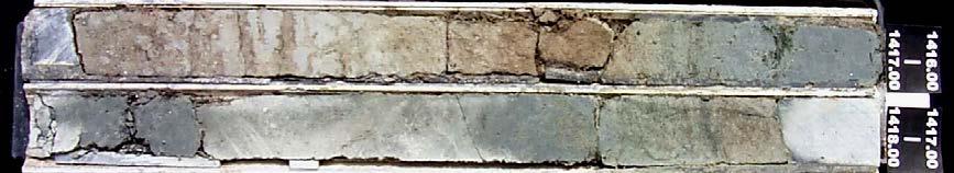
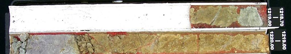
7 Figure 1. Core section of 6 wells, arranged in order of A, B, C, D, E, F, G 85


8 86
, with first publication rights granted to")
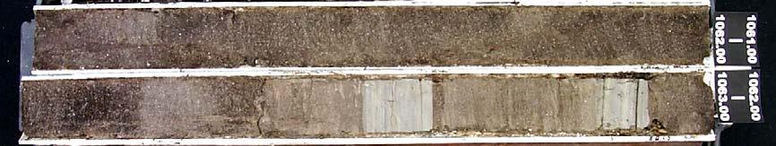
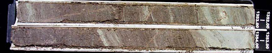
9 Figure 2. Core section of 8 wells, arranged in order of A, B, C, D, E, F, G, H, I, J, K, L Copyrights Copyright for this article is retained by the author(s), with first publication rights granted to the journal. This is an open-access article distributed under the terms and conditions of the Creative Commons Attribution license ( 87
The Research of source system on Chang 6 3 sand formation in Ansai oilfield
 IOSR Journal of Engineering (IOSRJEN) ISSN (e): 2250-3021, ISSN (p): 2278-8719 Vol. 05, Issue 08 (August. 2015), V1 PP 25-29 www.iosrjen.org Wang Jie (College of Earth Sciences, Northeast Petroleum University,
Lab 7: Sedimentary Structures
 Name: Lab 7: Sedimentary Structures Sedimentary rocks account for a negligibly small fraction of Earth s mass, yet they are commonly encountered because the processes that form them are ubiquitous in the
Sediment and sedimentary rocks Sediment
 Sediment and sedimentary rocks Sediment From sediments to sedimentary rocks (transportation, deposition, preservation and lithification) Types of sedimentary rocks (clastic, chemical and organic) Sedimentary
Study on Prediction Method of Fluvial Facies Sandbody in Fluvial Shallow Water Delta
 IOSR Journal of Applied Geology and Geophysics (IOSR-JAGG) e-issn: 2321 0990, p-issn: 2321 0982.Volume 5, Issue 3 Ver. II (May - June 2017), PP 43-47 www.iosrjournals.org Study on Prediction Method of
Sediment and Sedimentary rock
 Sediment and Sedimentary rock Sediment: An accumulation of loose mineral grains, such as boulders, pebbles, sand, silt or mud, which are not cemented together. Mechanical and chemical weathering produces
Sedimentary System Characteristics of Deng-3 Section on Paleo-central. Uplift Belt in Northern Songliao Basin. Siyang Li1,a*
 Sedimentary System Characteristics of Deng-3 Section on Paleo-central Uplift Belt in Northern Songliao Basin Siyang Li1,a* 1 School of Earth Sciences and Resources, China University of Geosciences, Beijing,
Study on the Couple of 3D Geological Model and Reservoir Numerical Simulation Results
 Advances in Petroleum Exploration and Development Vol. 13, No. 2, 2017, pp. 43-47 DOI:10.3968/9663 ISSN 1925-542X [Print] ISSN 1925-5438 [Online] www.cscanada.net www.cscanada.org Study on the Couple of
Sediment. Weathering: mechanical and chemical decomposition and disintegration of rock and minerals at the surface
 Sediment Some basic terminology Weathering: mechanical and chemical decomposition and disintegration of rock and minerals at the surface Erosion: removal of weathered rock and minerals from one place to
=%REPORT RECONNAISSANCE OF CHISHOLM LAKE PROSPECT. October 25, 1977
 =%REPORT ON FIELD RECONNAISSANCE OF CHISHOLM LAKE PROSPECT October 25, 1977 Bruce D. Vincent Imperial Oil Limited, Minerals - Coal, CALGARY, ALBERTA CHISHOLM LAKE PROSPECT Introduction The Chisholm Lake
Lecture Outline Wednesday - Friday February 14-16, 2018
 Lecture Outline Wednesday - Friday February 14-16, 2018 Quiz 2 scheduled for Friday Feb 23 (Interlude B, Chapters 6,7) Questions? Chapter 6 Pages of the Past: Sedimentary Rocks Key Points for today Be
Characteristics of the Sedimentary Microfacies of Fuyu Reservoir in Yushulin Oilfield, Songliao Basin
 IOSR Journal of Engineering (IOSRJEN) ISSN (e): 2250-3021, ISSN (p): 2278-8719 Vol. 06, Issue 03 (March. 2016), V3 PP 01-05 www.iosrjen.org Characteristics of the Sedimentary Microfacies of Fuyu Reservoir
Objectives: Define Relative Age, Absolute Age
 S6E5. Students will investigate the scientific view of how the earth s surface is formed. c. Classify rocks by their process of formation. g. Describe how fossils show evidence of the changing surface
Quantitative Relation of the Point BarWidth and Meander Belt Width of Subsurface Reservoir
 Advances in Petroleum Exploration and Development Vol. 13, No. 1, 2017, pp. 17-24 DOI:10.3968/9465 ISSN 1925-542X [Print] ISSN 1925-5438 [Online] www.cscanada.net www.cscanada.org Quantitative Relation
Data Repository item
 Data Repository (B25407): Localities and descriptions of measured sections of study areas Table 1. Localities of the measured sedimentary sections in the NW Sichuan Basin Section Number Stratigraphy Locality
Determination of Gas Well Productivity by Logging Parameters
 Earth Science Research; Vol. 6, No. ; 017 ISSN 197-054 E-ISSN 197-0550 Published by Canadian Center of Science and Education Determination of Gas Well Productivity by Logging Parameters Weijun Hao 1, Zhihong
Analysis of influence factors of oil and gas reservoir description accuracy
 IOP Conference Series: Earth and Environmental Science PAPER OPEN ACCESS Analysis of influence factors of oil and gas reservoir description accuracy To cite this article: Zhang Yu 2018 IOP Conf. Ser.:
Paleo Lab #4 - Sedimentary Environments
 Paleo Lab #4 - Sedimentary Environments page - 1. CHARACTERISTICS OF SEDIMENT Grain size and grain shape: The sizes and shapes of sedimentary particles (grains) are modified considerably during their transportation
Chapter 5. The Sedimentary Archives
 Chapter 5 The Sedimentary Archives Factors affecting Sedimentary Characteristics 1. Tectonic setting 2. Physical, chemical, and biological processes in the depositional environment 3. Method of sediment
American Journal of Energy Engineering
 American Journal of Energy Engineering 2017; 5(3): 11-16 http://www.sciencepublishinggroup.com/j/ajee doi: 10.11648/j.ajee.20170503.11 ISSN: 2329-1648 (Print); ISSN: 2329-163X (Online) Exploitation Evaluation
The Open Petroleum Engineering Journal
 Send Orders for Reprints to reprints@benthamscience.ae The Open Petroleum Engineering Journal, 2017, 10, 239-250 239 The Open Petroleum Engineering Journal Content list available at: www.benthamopen.com/topej/
MEMO. TO: Dennis Lapoint CC: FROM: Eriaan Wirosono DATE: April, 20 th 2014 SUBJECT: Exploration activity report March-April 2014_EW
 TO: Dennis Lapoint CC: FROM: Eriaan Wirosono DATE: April, 20 th 2014 SUBJECT: Exploration activity report March-April 2014_EW MEMO 1. Highlights and Productivity Overview pan sampling on target Areas 1
Sand. Sand is any eroded material (igneous, metamorphic or sedimentary) that has a grain size from 1/16 th to 2 millimeters in size.
 that has a grain size from 1/16 th to 2 millimeters in size.") Sedimentology 001 What is sedimentology? Sedimentology...encompasses the study of modern sediments such as sand [1], mud (silt) [2] andclay [3] and understanding the processes that deposit them.[4] It
Sedimentology 001 What is sedimentology? Sedimentology...encompasses the study of modern sediments such as sand [1], mud (silt) [2] andclay [3] and understanding the processes that deposit them.[4] It
Gravity Flow Sedimentary Characteristics of Chang 6 in Panke Area, Ordos Basin
 Ekoloji 27(106): 727-734 (2018) Gravity Flow Sedimentary Characteristics of Chang 6 in Panke Area, Ordos Basin Shasha Yang 1, Xuri Huang 1*, Cheng Yin 1, Yongqiang Xu 2, Juan Song 3, Runrong Cao 3 1 School
Stratigraphic Trap Identification Based on Restoration of Paleogeophology and Further Division of System Tract: A Case Study in Qingshui Subsag*
 Stratigraphic Trap Identification Based on Restoration of Paleogeophology and Further Division of System Tract: A Case Study in Qingshui Subsag* Cao Laisheng 1, Yu Lin 1, Liu Jianlun 1, Xiang Sheng 1,
GEOLOGY MEDIA SUITE Chapter 5
 UNDERSTANDING EARTH, SIXTH EDITION GROTZINGER JORDAN GEOLOGY MEDIA SUITE Chapter 5 Sedimentation Rocks Formed by Surface Processes 2010 W.H. Freeman and Company Mineralogy of sandstones Key Figure 5.12
Main controlling factors of hydrocarbon accumulation in Sujiatun oilfield of Lishu rift and its regularity in enrichment
 35 3 2016 9 GLOBAL GEOLOGY Vol. 35 No. 3 Sept. 2016 1004 5589 2016 03 0785 05 130062 P618. 130. 2 A doi 10. 3969 /j. issn. 1004-5589. 2016. 03. 019 Main controlling factors of hydrocarbon accumulation
Mammoth Cave National Park, Kentucky
 Mammoth Cave National Park, Kentucky Objectives of Today s Lecture Refresher on Sedimentary Depositional Systems and Rock Classifications Transgressive and Regressive Marine Environments Carbonate Depositional
Weathering, Erosion, Deposition, and Landscape Development
 Weathering, Erosion, Deposition, and Landscape Development I. Weathering - the breakdown of rocks into smaller particles, also called sediments, by natural processes. Weathering is further divided into
Sedimentary facies characteristics and oil/gas accumulation research of Fuyu Formation in Zhaoyuan area
 IOSR Journal of Engineering (IOSRJEN) ISSN (e): 2250-3021, ISSN (p): 2278-8719 Vol. 06, Issue 06 (June. 2016), V2 PP 08-12 www.iosrjen.org Sedimentary facies characteristics and oil/gas accumulation research
GY 111 Lecture Note Series Sedimentary Environments 2: Rivers and Deltas
 GY 111 Lecture Notes D. Haywick (2008-09) 1 GY 111 Lecture Note Series Sedimentary Environments 2: Rivers and Deltas Lecture Goals A) Rivers and Deltas (types) B) Water Flow and sedimentation in river/deltas
Geo 302D: Age of Dinosaurs. LAB 2: Sedimentary rocks and processes
 Geo 302D: Age of Dinosaurs LAB 2: Sedimentary rocks and processes Last week we covered the basic types of rocks and the rock cycle. This lab concentrates on sedimentary rocks. Sedimentary rocks have special
Geophysical methods for the study of sedimentary cycles
 DOI 10.1007/s12182-009-0041-9 259 Geophysical methods for the study of sedimentary cycles Xu Jingling 1, 2, Liu Luofu 1, 2, Wang Guiwen 1, 2, Shen Jinsong 1, 2 and Zhang Chunhua 3 1 School of Resources
The boundary between two formations (or any distinct layers) is called a contact. Sedimentary rocks cover 75% of continents.
 is called a contact. Sedimentary rocks cover 75% of continents.") Sedimentary Rocks Sedimentary rocks form at the Earth s surface through interactions of the hydrologic system and the crust. Fortunately, many of these processes are in operation today, and geologists
Sedimentary Rocks Sedimentary rocks form at the Earth s surface through interactions of the hydrologic system and the crust. Fortunately, many of these processes are in operation today, and geologists
Depositional Environment
 Depositional Environment Sedimentary depositional environment describes the combination of physical, chemical and biological processes associated with the deposition of a particular type of sediment. Types
NC Earth Science Essential Standards
 NC Earth Science Essential Standards EEn. 2.1 Explain how processes and forces affect the Lithosphere. EEn. 2.1.1 Explain how the rock cycle, plate tectonics, volcanoes, and earthquakes impact the Lithosphere.
Case Study of the Structural and Depositional-Evolution Interpretation from Seismic Data*
 Case Study of the Structural and Depositional-Evolution Interpretation from Seismic Data* Yun Ling 1, Xiangyu Guo 1, Jixiang Lin 1, and Desheng Sun 1 Search and Discovery Article #20143 (2012) Posted April
Application of seismic hydrocarbon detection technique to natural gas exploration-take Yingshan rift volcanic in the Yingcheng Groups as an instance
 IOSR Journal of Engineering (IOSRJEN) ISSN (e): 2250-3021, ISSN (p): 2278-8719 Vol. 05, Issue 10 (October. 2015), V1 PP 21-25 www.iosrjen.org Application of seismic hydrocarbon detection technique to natural
Image: G. Parker. Presenters: Henry Chan, Kayla Ireland, Mara Morgenstern, Jessica Palmer, Megan Scott
 Image: G. Parker Presenters: Henry Chan, Kayla Ireland, Mara Morgenstern, Jessica Palmer, Megan Scott Is the Ross Formation a suitable analog for sand-rich turbidite plays in passive margin basins? Play:
NAME: GEL 109 Final Study Guide - Winter 2008 Questions 6-24 WILL be on the final exactly as written here; this is 60% of the test.
 GEL 109 Final Study Guide - Winter 2008 Questions 6-24 WILL be on the final exactly as written here; this is 60% of the test. 1. Sketch a map view of three types of deltas showing the differences in river,
Study on the change of porosity and permeability of sandstone reservoir after water flooding
 IOSR Journal of Engineering (IOSRJEN) ISSN (e): 2250-3021, ISSN (p): 2278-8719 Vol. 06, Issue 02 (February. 2016), V2 PP 35-40 www.iosrjen.org Study on the change of porosity and permeability of sandstone
Section I: Multiple Choice Select the best answer to each question. Mark your final answer on the answer sheet. (1 pt each)
") Sedimentary Rocks & Surface Processes Quest Name: Earth Science 2013 Block: Date: Section I: Multiple Choice Select the best answer to each question. Mark your final answer on the answer sheet. (1 pt each)
Sedimentary Rocks & Surface Processes Quest Name: Earth Science 2013 Block: Date: Section I: Multiple Choice Select the best answer to each question. Mark your final answer on the answer sheet. (1 pt each)
Reservoir Type and Main Controlling Factors of Reservoir Forming in Block T of South Buir Sag
 Reservoir Type and Main Controlling Factors of Reservoir Forming in Block T21-7-3 of South Buir Sag Xinyao Wang College of earth science of Northeast Petroleum University, Daqing, Heilongjiang, China Abstract
Meandering Miocene Deep Sea Channel Systems Offshore Congo, West Africa
 Meandering Miocene Deep Sea Channel Systems Offshore Congo, West Africa S. Baer* (PGS), J. E. Comstock (PGS), K. Vrålstad (PGS), R. Borsato (PGS), M. Martin (PGS), J.P. Saba (SNPC), B. Débi-Obambé (SNPC)
The Analytic Hierarchy Process for the Reservoir Evaluation in Chaoyanggou Oilfield
 Advances in Petroleum Exploration and Development Vol. 6, No. 2, 213, pp. 46-5 DOI:1.3968/j.aped.1925543821362.1812 ISSN 1925-542X [Print] ISSN 1925-5438 [Online].cscanada.net.cscanada.org The Analytic
Clastic Sedimentary Rocks
 Clastic Sedimentary Rocks Alessandro Grippo, Ph.D. Alternating sandstones and mudstones in Miocene turbidites Camaggiore di Firenzuola, Firenze, Italy Alessandro Grippo review Mechanical weathering creates
BALOCHISTAN FOLDBELT BASIN
 INTRODUCTION BALOCHISTAN FOLDBELT BASIN The Kharan-3 block is located in the Kharan Trough of Balochistan Basin. GEOLOGICAL SETTING The Balochistan Province is an Upper Cretaceous to Recent structurally
Chapter 3 Sedimentation of clay minerals
 Chapter 3 Sedimentation of clay minerals 3.1 Clay sedimentation on land 3.2 From land to sea 3.3 Clay sedimentation in the sea 1 3.1 Clay sedimentation on land Deserts Glaciers Rivers Lacustrine 2 University
EARTH SURFACE PROCESSES AND SEDIMENTATION!
 Sed and Strat EARTH SURFACE PROCESSES AND SEDIMENTATION! 2/27 Lecture 7- Exposure: Weathering and the Sediment Factory 3/04 Lecture 8 - Rivers and Landscapes 3/06 Lecture 9 - Waves (not Tides) 3/11 Lecture
Sedimentary Rocks. Origin, Properties and Identification. Geology Laboratory GEOL 101 Lab Ray Rector - Instructor
 Sedimentary Rocks Origin, Properties and Identification Geology Laboratory GEOL 101 Lab Ray Rector - Instructor Sedimentary Rock Origin and Identification Lab Pre-Lab Internet Link Resources 1) http://www.rockhounds.com/rockshop/rockkey/index.html
Ecoregions Glossary. 7.8B: Changes To Texas Land Earth and Space
 Ecoregions Glossary Ecoregions The term ecoregions was developed by combining the terms ecology and region. Ecology is the study of the interrelationship of organisms and their environments. The term,
Objectives. Introduction to Soils. Terms to know: What is soil? Study of Soils. The Soil Body 11/9/2012
 Objectives Explain what soil is and where it comes from Define a soil body List examples of the five soil-forming factors Explain how soils develop Introduction to Soils Terms to know: What is soil? Alluvial
The Seismic-Geological Comprehensive Prediction Method of the Low Permeability Calcareous Sandstone Reservoir
 Open Journal of Geology, 2016, 6, 757-762 Published Online August 2016 in SciRes. http://www.scirp.org/journal/ojg http://dx.doi.org/10.4236/ojg.2016.68058 The Seismic-Geological Comprehensive Prediction
Ministry of Minerals Geological Research Authority of Sudan (GRAS)
") ﺑﺴﻢ اﷲ اﻟﺮﺣﻤﻦ اﻟﺮﺣﯿﻢ Ministry of Minerals Geological Research Authority of Sudan (GRAS) Bentonite Deposits of Omm Ali Area (River Nile State) Sudan By: El Gizouli Ahmed Hamid. February 2011 Abstract The
ﺑﺴﻢ اﷲ اﻟﺮﺣﻤﻦ اﻟﺮﺣﯿﻢ Ministry of Minerals Geological Research Authority of Sudan (GRAS) Bentonite Deposits of Omm Ali Area (River Nile State) Sudan By: El Gizouli Ahmed Hamid. February 2011 Abstract The
Evaluation on source rocks and the oil-source correlation in Bayanhushu sag of Hailaer Basin
 30 2 2011 6 GLOBAL GEOLOGY Vol. 30 No. 2 Jun. 2011 1004-5589 2011 02-0231 - 07 163712 3 7 Ⅰ Ⅱ1 3 - - P618. 130 A doi 10. 3969 /j. issn. 1004-5589. 2011. 02. 011 Evaluation on source rocks and the oil-source
Understanding Earth Fifth Edition
 Understanding Earth Fifth Edition Grotzinger Jordan Press Siever Chapter 5: SEDIMENTATION: Rocks Formed by Surface Processes Lecturer: H Mohammadzadeh Assistant professors, Department of Geology, FUM Copyright
MUHAMMAD S TAMANNAI, DOUGLAS WINSTONE, IAN DEIGHTON & PETER CONN, TGS Nopec Geological Products and Services, London, United Kingdom
 Geological and Geophysical Evaluation of Offshore Morondava Frontier Basin based on Satellite Gravity, Well and regional 2D Seismic Data Interpretation MUHAMMAD S TAMANNAI, DOUGLAS WINSTONE, IAN DEIGHTON
EROSION, DEPOSITION AND SEDIMENTARY ROCKS. Reading: Earth Science Tarbuck and Lutgens Chapter 5: pages Chapter 3: pages 52-54, 61-69
 EROSION, DEPOSITION AND SEDIMENTARY ROCKS Reading: Earth Science Tarbuck and Lutgens Chapter 5: pages 124-133 Chapter 3: pages 52-54, 61-69 Base Level Resistant bed Resistant bed creates a local base level
Facies Analysis of the Lower Cretaceous Wilrich Member (Lower Falher) of the Spirit River Formation.
 of the Spirit River Formation.") Facies Analysis of the Lower Cretaceous Wilrich Member (Lower Falher) of the Spirit River Formation. Kerrie L. Bann, Ichnofacies Analysis Inc. and Daniel J. K. Ross, Tourmaline Oil Corp. Historically,
Facies Analysis of the Lower Cretaceous Wilrich Member (Lower Falher) of the Spirit River Formation. Kerrie L. Bann, Ichnofacies Analysis Inc. and Daniel J. K. Ross, Tourmaline Oil Corp. Historically,
The physical breakdown and chemical alteration of rocks and minerals at or near Earth s surface.
 The physical breakdown and chemical alteration of rocks and minerals at or near Earth s surface. The material that is chemically and mechanically weathered to yield sediment and soil. Regolith consisting
SUPPLEMENTAL MATERIAL
 SUPPLEMENTAL MATERIAL DESCRIPTIONS OF OTHER STRATIGRAPHIC SECTIONS Cherry Creek In its middle reaches, Cherry Creek meanders between three paired terraces within a narrow bedrock valley. The highest is
Summary. Introduction. Observations and Interpretations
 Lower McMurray Formation sinkholes and their fill fabrics: effects of salt dissolution collapse-subsidence across the northern Athabasca oil sands deposit Paul L. Broughton, Chevron Canada Resources, Calgary,
Chang Wenbo.
 The spatial and temporal distributions of the late Mesozoic volcanic successions in the Changling fa ult depression of the Songliao Basin, NE China, and their controlling effects Chang Wenbo susanna0703@163.com
Sedimentary Rocks. Origin, Properties and Identification. Physical Geology GEOL 101 Lab Ray Rector - Instructor
 Sedimentary Rocks Origin, Properties and Identification Physical Geology GEOL 101 Lab Ray Rector - Instructor Sedimentary Rock Origin and Identification Lab Pre-Lab Internet Link Resources 1) http://www.rockhounds.com/rockshop/rockkey/index.html
Main controlling factors of remaining oil and favorable area prediction of Xinli oilfield VI block
 IOSR Journal of Engineering (IOSRJEN) ISSN (e): 2250-3021, ISSN (p): 2278-8719 Vol. 05, Issue 03 (March. 2015), V1 PP 06-10 www.iosrjen.org Main controlling factors of remaining oil and favorable area
entered a rapid development phase. Annual increased proven reserves are above 500 billion cubic meters (bcm) from 2003, and annual natural gas product
 from 2003, and annual natural gas product") (), entered a rapid development phase. Annual increased proven reserves are above 500 billion cubic meters (bcm) from 2003, and annual natural gas production has increased from 50bcm in 2000 to nearly
(), entered a rapid development phase. Annual increased proven reserves are above 500 billion cubic meters (bcm) from 2003, and annual natural gas production has increased from 50bcm in 2000 to nearly
Lowest and Youngest Terrace : Soil Pit #4
 Lowest and Youngest Terrace : Soil Pit #4 Observations : Where : Huntington Terraces Climate : Cloudy, mid 60 s Our soil pit was the lowest of the 4 sites The pit site was located on the right side of
NAME: GEL 109 Final Winter 2010
 GEL 109 Final Winter 2010 1. The following stratigraphic sections represents a single event followed by the slow accumulation of background sedimentation of shale. Describe the flows that produced the
Study on the Four- property Relationship of Reservoirs in YK Area of Ganguyi Oilfield
 Study on the Four- property elationship of eservoirs in YK Area of Ganguyi Oilfield Abstract Xinhu Li, Yingrun Shang Xi an University of Science and Technology, Xi an 710054, China. shangyingrun@163.com
Weathering, Erosion and Deposition
 Weathering, Erosion and Deposition Shaping the Earth s Surface Weathering the process of breaking down rocks into smaller fragments Erosion the transport of rock fragments from one location to another
Sediments and Sedimentary Rocks
 Sediments and Sedimentary Rocks (Shaping Earth s Surface, Part 2) Science 330 Summer 2005 What is a sedimentary rock? Products of mechanical and chemical weathering Account for about 5 percent of Earth
STUDY GUIDE FOR CONTENT MASTERY. Surface Water Movement
 Surface Water SECTION 9.1 Surface Water Movement In your textbook, read about surface water and the way in which it moves sediment. Complete each statement. 1. An excessive amount of water flowing downslope
Sedimentary Rocks. Origin, Properties and Identification. Physical Geology GEOL 100. Ray Rector - Instructor
 Sedimentary Rocks Origin, Properties and Identification Physical Geology GEOL 100 Ray Rector - Instructor Sedimentary Rock Origin and Identification Lab Pre-Lab Internet Link Resources 1) http://www.rockhounds.com/rockshop/rockkey/index.html
ESC102. Sedimentary Rocks. Our keys to the past. Monday, February 11, 13
 ESC102 Sedimentary Rocks Our keys to the past Sedimentary Rocks Sedimentary rocks are rocks that form through the accumulation of sediment and the process of lithification. Lithification occurs after deposition
Monitoring and modelling hydrological fluxes in support of nutrient cycling studies in Amazonian rain forest ecosystems Tobon-Marin, C.
 UvA-DARE (Digital Academic Repository) Monitoring and modelling hydrological fluxes in support of nutrient cycling studies in Amazonian rain forest ecosystems Tobon-Marin, C. Link to publication Citation
Soil Profiles (West, Ch. 8)
") Geology 229 Engineering Geology Lecture 24 Soil Profiles (West, Ch. 8) We have just finished the discussion of rock weathering. One direct consequence of weathering is the formation of the soil profile.
Geology 229 Engineering Geology Lecture 24 Soil Profiles (West, Ch. 8) We have just finished the discussion of rock weathering. One direct consequence of weathering is the formation of the soil profile.
Depositional Environments. Depositional Environments
 Depositional Environments Geographic area in which sediment is deposited Characterized by a combination of geological process & environmental conditions Depositional Environments Geological processes:
Coso Red Hill and Coso Playa field trip, Prof. Alessandro Grippo, Ph.D.
 HISTORICAL GEOLOGY fall 2016 Professor: Dr. Alessandro Grippo, Ph.D. FIELD TRIP REPORT: Friday, October 21, 2016: Coso Red Hill & Playa, Coso Junction CA YOUR NAME part 1: COSO RED HILL (you can sample
Characterization of Sand Formation from a Crude Oilfield
 This work by IJARBEST is licensed under Creative Commons Attribution 4.0 International License. Available at https://www.ijarbest.com Characterization of Sand Formation from a Crude Oilfield 1 A. Sivasakthi,
 UNIT DESCRIPTIONS: Artificial Fill, Undocumented (Afu): Locally derived sandy silt and silty sand, locally with clay and varying amounts of gravel and man-made debris. Abundant concrete rubble, in places
Bulletin of Earth Sciences of Thailand
 Depositional Environments and Stratigraphic Development of the Grand Taman Sari Circuit Outcrop: an Analogue for Transgressive Mahakam Delta Successions Ridha Santika Riadi Petroleum Geoscience Program,
Bulletin of Earth Sciences of Thailand. Evaluation of the Petroleum Systems in the Lanta-Similan Area, Northern Pattani Basin, Gulf of Thailand
 Evaluation of the Petroleum Systems in the Lanta-Similan Area, Northern Pattani Basin, Gulf of Thailand Sirajum Munira Petroleum Geoscience Program, Department of Geology, Faculty of Science, Chulalongkorn
Figure 1 The map shows the top view of a meandering stream as it enters a lake. At which points along the stream are erosion and deposition dominant?
 1. In which type of climate does chemical weathering usually occur most rapidly? 1. hot and dry 3. cold and dry 2. hot and wet 4. cold and wet 2. Figure 1 The map shows the top view of a meandering stream
Cattaraugus Creek: A Story of Flowing Water and the Geology of the Channel It Flows Through Presentation to West Valley Citizen Task Force 4/27/16
 Cattaraugus Creek: A Story of Flowing Water and the Geology of the Channel It Flows Through Presentation to West Valley Citizen Task Force 4/27/16 Raymond C. Vaughan, Ph.D. What happens if you drop a
Class Notes: Surface Processes
 Name: Date: Period: Surface Processes The Physical Setting: Earth Science Class Notes: Surface Processes I. Weathering and Soils Weathering -! Sediments -! Weathering occurs when rocks are exposed to:
INVESTIGATING AND UNDERSTANDING THE GROUND WHY BOTHER?
 INVESTIGATING AND UNDERSTANDING THE GROUND WHY BOTHER? Dr Jacqueline Skipper Geotechnical Consulting Group WHAT IS UNDERSTANDING THE GROUND? Site Good enough ground model for successful project construction
Surface Water Short Study Guide
 Name: Class: Date: Surface Water Short Study Guide Multiple Choice Identify the letter of the choice that best completes the statement or answers the question. 1. The three ways in which a stream carries
Chapter 6 Sedimentary and Metamorphic Rock
 Chapter 6 Sedimentary and Metamorphic Rock Weathering and Erosion Wherever rock is exposed at Earth s surface, it is continuously being broken down by weathering a set of physical and chemical processes
Macro heterogeneity of high porosity and permeability reservoirin Bozhong 25-1 oil field under section as an example
 IOSR Journal of Applied Geology and Geophysics (IOSR-JAGG e-issn: 221 0990, p-issn: 221 092.Volume, Issue 6 Ver. II (Nov. - Dec. 201, PP 61-6 www.iosrjournals.org Macro heterogeneity of high porosity and
Depositional History and Petroleum Potential of Ombilin Basin, West Sumatra - Indonesia, Based on Surface Geological Data*
 Depositional History and Petroleum Potential of Ombilin Basin, West Sumatra - Indonesia, Based on Surface Geological Data* Yahdi Zaim 1, Litto Habrianta 2, Chalid I. Abdullah 1, Aswan 1, Yan Rizal 1, Nurcahyo
UK Field Training Courses
 UK Field Training Courses Bespoke courses for E&P companies For individual companies and/or partnerships Reservoir and exploration sedimentology oriented Integrated with company sedimentologist if desired
Ground-Water Exploration in the Worthington Area of Nobles County: Summary of Seismic Data and Recent Test Drilling Results
 Ground-Water Exploration in the Worthington Area of Nobles County: Summary of Seismic Data and Recent Test Drilling Results Jim Berg and Todd Petersen Geophysicists, DNR Waters January 2000 Table of Contents
Measurement of the organic saturation and organic porosity in. shale
 Measurement of the organic saturation and organic porosity in shale Qian Sang a,b, Shaojie Zhang a, Yajun Li a, Mingzhe Dong a,b Steven Bryant b a College of Petroleum Engineering, China University of
The characteristics of fracture dense belt and its effect on hydrocarbon. accumulation in the Putaohua reservoir, Xingnan oilfield, Daqing
 The characteristics of fracture dense belt and its effect on hydrocarbon accumulation in the Putaohua reservoir, Xingnan oilfield, Daqing 1 Y.Y. YIN,2 Zh. Luo, 3Q. Li, 4X.R. Wang 1 School of Energy Resources,
A Sedimentary Rock is..
 Sedimentary Rocks A Sedimentary Rock is.. rock formed from the lithification or crystallization of: 1. Minerals in solution 2. Organic remains 3. Materials produced by living things (biochemical) 4. Clastic
 29 4 20 8 ACTA SEDIMENTOLOGICA SINICA Vol. 29 No. 4 Aug. 20 000-0550 20 04-0809-06 2 2 3. 730000 2. 00049 3. 067000 8 W008 ~ W05 20 cm 50 cm 00 cm 80 cm 300 cm 500 cm 000 cm 700 cm R o H /C O /C A 5 80
Description DESCRIPTION
 DESCRIPTION The location of the Upper James Watershed is located in northeastern South Dakota as well as southeastern North Dakota. It includes the following counties located in North Dakota Barnes, Dickey,
Jim Turenne. Soils on Social Media
 Jim Turenne USDA-NRCS 60 Quaker Lane, Suite 46 Warwick, RI. 02886 401-822-8832 Jim.turenne@ri.usda.gov Soils on Social Media www.twitter.com/soilsne www.fb.com/soilsne www.nesoil.com U.S. Department of
Geology 252, Historical Geology, California State University, Los Angeles - professor: Dr. Alessandro Grippo
 LAB # 1 - CLASTIC ROCKS Background: - Mechanical and Chemical Weathering - Production of Clastic Sediment - Classification of Sediment according to size: Gravel, Sand, Silt, Clay - Erosion, Transportation
Outcrops from Every Continent and 20 Countries in 140 Contributions. Tor H. Nilsen, Roger D. Shew, Gary S. Steffens, and Joseph R.J. Studlick.
 Paper VIII Tor H. Nilsen, Roger D. Shew, Gary S. Steffens, and Joseph R.J. Studlick Editors Outcrops from Every Continent and 20 Countries in 140 Contributions http://bookstore.aapg.org Length ~ 23 m (75.5
Sedimentary Rocks. Weathering. Mechanical & Chemical Weathering. Sediments. Lithification. Deposition. Transport. Erosion.
 Lithification Sedimentary Rocks Sediments Deposition Transport Erosion Weathering Weathering The sediments that make up sedimentary rocks are produced by: Mechanical & Chemical Weathering Mechanical Weathering