Ongoing Oroclinal bending in the Cascadia forearc and its relation to concave-outboard plate margin geometry
|
|
|
- Georgina Skinner
- 5 years ago
- Views:
Transcription
1 GSA DATA REPOSITORY Ongoing Oroclinal bending in the Cascadia forearc and its relation to concave-outboard plate margin geometry Theron Finley 1,2, Kristin Morell 1,3, Lucinda Leonard 1, Christine Regalla 4, Stephen T. Johnston 2, and Wenbo Zhang 1,2 1 School of Earth and Ocean Sciences, University of Victoria, 3800 Finnerty Rd., Victoria, BC, Canada, V8P 5C2 2 Dept. of Earth and Atmospheric Sciences, University of Alberta, 1-26 Earth Sciences Bldg., Edmonton, AB, Canada, T6G 2E3 3 Dept. of Earth Sciences, University of California, Santa Barbara, 1006 Webb Hall, Santa Barbara, CA, Dept. of Earth and Environment, Boston University, 685 Commonwealth Ave., Boston, MA, U.S.A., Supplementary Data: Figure DR1. Structural data from the Olympic Peninsula. Table DR1. Comparison between paleomagnetic and GNSS-derived rotation rates in the Cascadia forearc Supplemental Methods: GNSS Rotation Analysis


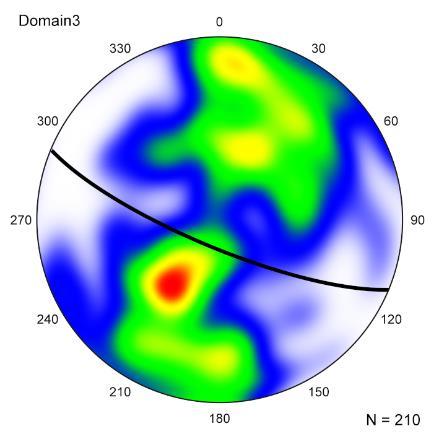
2 Domain 1: 309/33 Domain 2: 289/50 Domain 3: 113/77


3 Domain 4: 358/30 Domain 5:024/49 Domain 6: 065/42 Domain 7: 087/30 Domain 8: 344/33 Domain 9: 292/79 Domain 10: 145/55 Domain 11: 173/67 Domain 12: 210/75


4 Domain 13: 142/58 Domain 14: 166/58 Domain 15: 162/54 Domain 16: 334/50 Domain 17: 291/62 Domain 18: 106/89 Domain 19: 341/68 Domain 20: 340/90 Domain 21: 026/82
5 Domain 22: 326/57 Domain 23: 008/40 Figure DR1. A: Map of foliation measurements (n=4125) on the Olympic Peninsula (Washington Geological Survey, 2017), divided into 23 structural domains. The outer and inner edges of most domains correspond to major faults, while the along-strike boundaries correspond to obvious changes in strike evident by visual inspection of the data. B: Equal-angle lowerhemisphere stereoplots of foliation data for each structural domain in part A (n=23). Black great circles show the best-fit plane for each domain, while contours show the distribution of poles to all foliation planes in each domain, illustrating the coherence of each dataset; red indicates high concentration of poles, white indicates low concentration.
6 Table DR1. Comparison between paleomagnetic and GNSS-derived rotation rates in the Cascadia forearc. Paleomagnetic rotation rates are calculated based on the assumption that oroclinal bending began at 18 Ma at the onset of uplift of the Olympic Mountains. Co-located GNSS rotation rates are taken from grid cells (Fig. 3) overlapping paleomagnetic sample locations. Average rotation rates based on the entire GNSS-rotation dataset are calculated for north and south limbs of the orocline, and for the entire forearc. Paleomagnetic Data GNSS Data North Limb South Limb Sample Site ( N, E) Sooke Formation (48.4, ) East Sooke Gabbro (48.3, ) Port Townsend Basalts (48.0, ) Bremerton Basalts (47.5, ) Black Hills Volcanics (46.9, ) Willapa Hills Volcanics (46.3, ) Reference Paleomag. Declination ( ) Paleomag. Rotation Rate Prothero et al. (2008) -35 ± ± 0.7 Average Limb Rotation Rate Overall Absolute Average Rotation Rate Co-located GNSS Rotation Rate -0.6 ± 0.2 Symons (1973) -20 ± ± ± ± 1.5 Beck and Engebretson (1982) -14 ± ± ± 0.1 Beck and Engebretson (1982) 12 ± ± ± ± 0.1 Globerman et al. (1982) 29 ± ± ± ± 0.5 Wells and Coe (1985) 24 ± ± ± 0.1 Average Limb Rotation Rates ± ± 0.14 Overall Absolute Average Rotation Rate 0.96 ± 0.85
7 Supplemental Methods: GNSS Rotation Analysis We analyzed 25-years worth of GNSS velocity data from 923 sites from the UNAVCO Plate Boundary Observatory database ( and from McCaffrey et al. (2013) (Figure 2). Continuous GNSS time series (n=282) range from years to decades (mean 10.3 years), while campaign site time series (n=641) have an average length of 6.5 years. Uncertainty is typically higher for campaign sites than for continuous sites, and those with exceptionally high uncertainty (>5 mm/yr) were removed from the dataset. We used an adaptive Gaussian smoothing function to interpolate crustal velocity at regular grid points spaced by 0.2 degrees of latitude and longitude after Mazzotti et al. (2011). Velocity was calculated at each grid point, as an average of all velocity vectors in the study area, weighted according to standard error and distance to the grid point. An azimuthal weighting factor was also applied to account for the variation in number of GNSS stations over a given azimuthal window (22.5 ); lower weight was assigned to stations within a high density sector. The half-width (smoothing distance) of the Gaussian function was defined either by a minimum distance or a distance to the N th nearest neighbor, whichever was lower, thereby allowing for variable smoothing depending on the density of sites surrounding each grid point. After testing several combinations of smoothing parameters, we selected a minimum distance and N th nearest neighbor of 50 km and N=5 respectively, which produced minimal noise while retaining local data structure. To obtain annual rotation rates from velocity, the algorithm calculates the curl of the gridded velocity field with respect to position, the result of which is shown in Fig. 3. Regional patterns in rotational direction (i.e. clockwise versus counterclockwise) were relatively insensitive to changes in smoothing parameters, with key transition zones staying in the same place regardless of the
8 Gaussian half-width. Absolute magnitudes of rotation were dampened by broader smoothing functions. Standard error for the resulting rotation field was determined using a Monte Carlo simulation, wherein one thousand random velocities were generated within the uncertainty range of the raw data, and one thousand bootstrap velocities were sampled from the raw data. References Beck, M.E., and Engebretson, D.C., 1982, Paleomagnetism of small basalt exposures in the West Puget Sound Area, Washington, and Speculations on the accretionary origin of the Olympic Mountains: Journal of Geophysical Research, v. 87, p Globerman, B., Beck, M., and Duncan, R., 1982, Paleomagnetism and tectonic significance of Eocene basalts from the Black Hills, Washington Coast Range: Geological Society of America Bulletin, v. 93, p Mazzotti, S., Leonard, L.J., Cassidy, J.F., Rogers, G.C., and Halchuk, S., 2011, Seismic hazard in western Canada from GPS strain rates vs. earthquake catalog: Journal of Geophysical Research, v. 116, B08406, doi: /2011JB McCaffrey, R., King, R.W., Payne, S.J., and Lancaster, M., 2013, Active tectonics of northwestern U.S. inferred from GPS-derived surface velocities: Journal of Geophysical Research: Solid Earth, v. 118, p , doi: /2012JB Prothero, D.R., Draus, E., Cockburn, T.C., and Nesbitt, E.A., 2008, Paleomagnetism and counterclockwise tectonic rotation of the Upper Oligocene Sooke Formation, southern Vancouver Island, British Columbia: Canadian Journal of Earth Sciences, v. 45, p , doi: /E Symons, D.T.A., 1973, Paleomagnetic Zones in the Oligocene East Sooke Gabro, Vancouver Island, British Columbia: Journal of Geophysical Research, v. 78, p
9 Washington Geological Survey, 2017, Surface geology, 1:24,000 GIS data, September 2017: Washington Geological Survey Digital Data Series DS-10, version 3.0, previously released November Wells, R.E., and Coe, R.S., 1985, Paleomagnetism and geology of Eocene volcanic rocks of southwest Washington, implications for mechanisms of tectonic Rotation: Journal of Geophysical Research: Solid Earth, v. 90, p , doi: /JB090iB02p01925.
Activity Pacific Northwest Tectonic Block Model
 Activity Pacific Northwest Tectonic Block Model The Cascadia tectonic margin is caught between several tectonic forces, during the relentless motions of the giant Pacific Plate, the smaller subducting
Frequency of large crustal earthquakes in Puget Sound Southern Georgia Strait predicted from geodetic and geological deformation rates
 JOURNAL OF GEOPHYSICAL RESEARCH, VOL. 108, NO. B1, 2033, doi:10.1029/2001jb001710, 2003 Frequency of large crustal earthquakes in Puget Sound Southern Georgia Strait predicted from geodetic and geological
by west-dipping subduction of the North American Plate
 GSA Data Repository 2019133 Supplementary information for Kimberlite magmatism induced by west-dipping subduction of the North American Plate Wenbo Zhang 1*, Stephen T. Johnston 1, and Claire A. Currie
Segmentation in episodic tremor and slip all along Cascadia
 Segmentation in episodic tremor and slip all along Cascadia Michael R. Brudzinski and Richard M. Allen Geology 35 (10) 907-910, 2007, doi: 10.1130/G23740A.1 Data Repository: Methods for Automated Data
Knowledge of in-slab earthquakes needed to improve seismic hazard estimates for southwestern British Columbia
 USGS OPEN FILE REPORT #: Intraslab Earthquakes 1 Knowledge of in-slab earthquakes needed to improve seismic hazard estimates for southwestern British Columbia John Adams and Stephen Halchuk Geological
GPS Strain & Earthquakes Unit 3: Finding location and velocity data for PBO GPS stations
 GPS Strain & Earthquakes Unit 3: Finding location and velocity data for PBO GPS stations Original activity by Vince Cronin (Baylor University). Revisions by Beth Pratt-Sitaula (UNAVCO). Analyzing the velocities
Geo-Marine Letters Volume 36, 2016, electronic supplementary material
 1 Geo-Marine Letters Volume 36, 016, electronic supplementary material Submarine landslides offshore Vancouver Island along the northern Cascadia margin, British Columbia: why preconditioning is likely
What scientists know and do not know about the big one at Cascadia
 What scientists know and do not know about the big one at Cascadia Kelin Wang Pacific Geoscience Centre, Geological Survey of Canada Natural Resources Canada The Cascadia Subduction Zone M 7.3, 1946 Rupture
Dynamic Crust Practice
 1. Base your answer to the following question on the cross section below and on your knowledge of Earth science. The cross section represents the distance and age of ocean-floor bedrock found on both sides
GPS strain analysis examples Instructor notes
 GPS strain analysis examples Instructor notes Compiled by Phil Resor (Wesleyan University) This document presents several examples of GPS station triplets for different tectonic environments. These examples
Lab 9: Satellite Geodesy (35 points)
") Lab 9: Satellite Geodesy (35 points) Here you will work with GPS Time Series data to explore plate motion and deformation in California. This lab modifies an exercise found here: http://www.unavco.org:8080/cws/pbonucleus/draftresources/sanandreas/
Lab 9: Satellite Geodesy (35 points) Here you will work with GPS Time Series data to explore plate motion and deformation in California. This lab modifies an exercise found here: http://www.unavco.org:8080/cws/pbonucleus/draftresources/sanandreas/
GPS Strain & Earthquakes Unit 4: GPS strain analysis examples Student exercise
 GPS Strain & Earthquakes Unit 4: GPS strain analysis examples Student exercise Example 1: Olympic Peninsula Name: Please complete the following worksheet to estimate, calculate, and interpret the strain
QUALITATIVE INTERPRETATION OF POTENTIAL FIELD PROFILES: SOUTHERN NECHAKO BASIN
 QUALITATIVE INTERPRETATION OF POTENTIAL FIELD PROFILES: SOUTHERN NECHAKO BASIN By Melvyn E. Best Bemex Consulting International 5288 Cordova Bay Road Victoria, B.C. V8Y 2L4 KEYWORDS: potential fields,
SECTION 2 How Is Pacific Northwest Climate Changing?
 SECTION 2 How Is Pacific Northwest Climate Changing? The Pacific Northwest is experiencing a suite of long-term changes that are consistent with those observed globally as a result of human-caused climate
GPS Strain & Earthquakes Unit 5: 2014 South Napa earthquake GPS strain analysis student exercise
 GPS Strain & Earthquakes Unit 5: 2014 South Napa earthquake GPS strain analysis student exercise Strain Analysis Introduction Name: The earthquake cycle can be viewed as a process of slow strain accumulation
6. In the diagram below, letters A and B represent locations near the edge of a continent.
 1. Base your answer to the following question on the cross section below and on your knowledge of Earth science. The cross section represents the distance and age of ocean-floor bedrock found on both sides
EPSS 15. Spring Introduction to Oceanography. Laboratory #1 Maps, Cross-sections, Vertical Exaggeration, Graphs, and Contour Skills 4/7/17
 EPSS 15 Spring 2017 Introduction to Oceanography Laboratory #1 Maps, Cross-sections, Vertical Exaggeration, Graphs, and Contour Skills MAPS Provide valuable interface to explore the geography of the world
Overview of the Seismic Source Characterization for the Palo Verde Nuclear Generating Station
 Overview of the Seismic Source Characterization for the Palo Verde Nuclear Generating Station Scott Lindvall SSC TI Team Lead Palo Verde SSC SSHAC Level 3 Project Tuesday, March 19, 2013 1 Questions from
NAME HOMEWORK ASSIGNMENT #4 MATERIAL COVERS CHAPTERS 19, 20, 21, & 2
 NAME HOMEWORK ASSIGNMENT #4 MATERIAL COVERS CHAPTERS 19, 20, 21, & 2 Assignment is due the beginning of the class period on December 14, 2004. Mark answers on a scantron sheet, which will be provided.
Northward migration of the Cascadia forearc in the northwestern U.S. and implications for subduction deformation
 Earth Planets Space, 53, 275 283, 2001 Northward migration of the Cascadia forearc in the northwestern U.S. and implications for subduction deformation Ray E. Wells and Robert W. Simpson U.S. Geological
LAB: PLATE TECTONICS GOAL: Calculate rates of plate movement
 Name LAB: PLATE TECTONICS GOAL: Calculate rates of plate movement Rates of plate movement are calculated by measuring the distance rocks have moved since they formed. Rates are expressed in cm per year
Geological & Geophysical Interpretation of ZTEM EM and Magnetic Survey. Kemess Project, BC. for AuRico Metals Inc. September, 2016 Nicole Pendrigh
 Geological & Geophysical Interpretation of ZTEM EM and Magnetic Survey Kemess Project, BC for AuRico Metals Inc. September, 2016 Nicole Pendrigh SUMMARY REPORT Regional setting Located in North central
Dynamic Subsidence and Uplift of the Colorado Plateau. Supplementary Material
 GSA DATA REPOSITORY 2010177 Liu and Gurnis Dynamic Subsidence and Uplift of the Colorado Plateau Supplementary Material Lijun Liu and Michael Gurnis Seismological Laboratory California Institute of Technology
Unit 1 Physical Setting
 Unit 1 Physical Setting Chapter 1: Finding Your Way Chapter 2: Our Natural Environment Chapter 3: The Changing Weather Chapter 4: A Place To Live Chapter 1: Finding Our Way Key Terms Lines of Latitude
Lecture 4: Earthquakes and Seismic Waves
 Lecture 4: Earthquakes and Seismic Waves Key Questions 1. What are the sources for EQs in the PNW? 2. What is a seismograph and seismogram? 3. What is the difference between Richter magnitudes and Mercalli
Comment on A new estimate for present-day Cocos-Caribbean plate motion: Implications
 Comment on A new estimate for present-day Cocos-Caribbean plate motion: Implications for slip along the Central American volcanic arc by Charles DeMets Marco Guzmán-Speziale Juan Martín Gómez Unidad de
Regional deformation and kinematics from GPS data
 Regional deformation and kinematics from GPS data Jessica Murray, Jerry Svarc, Elizabeth Hearn, and Wayne Thatcher U. S. Geological Survey Acknowledgements: Rob McCaffrey, Portland State University UCERF3
Scientific Research on the Cascadia Subduction Zone that Will Help Improve Seismic Hazard Maps, Building Codes, and Other Risk-Mitigation Measures
 Scientific Research on the Cascadia Subduction Zone that Will Help Improve Seismic Hazard Maps, Building Codes, and Other Risk-Mitigation Measures Art Frankel U.S. Geological Survey Seattle, WA GeoPrisms-Earthscope
GEOL.3250 Geology for Engineers Plate Tectonics - Geomagnetism, Earthquakes, and Gravity
 Name GEOL.3250 Geology for Engineers Plate Tectonics - Geomagnetism, Earthquakes, and Gravity I. Geomagnetism The earth's magnetic field can be viewed as a simple bar magnet located near the center of
Topics Laramide Orogeny: Late Cretaceous to Early Eocene Reading: GSA DNAG volume 3, Ch. 6
 Topics Laramide Orogeny: Late Cretaceous to Early Eocene Reading: GSA DNAG volume 3, Ch. 6 Late Cretaceous to early Eocene New patterns developed 5 main regions Tectonic interpretations Post-Laramide events
Electronic supplement for Forearc motion and deformation between El Salvador and Nicaragua: GPS, seismic, structural, and paleomagnetic observations
 DR2011053 Electronic supplement for Forearc motion and deformation between El Salvador and Nicaragua: GPS, seismic, structural, and paleomagnetic observations by D. Alvarado et al., Lithosphere, April,
The Tectonic Setting of New Zealand
 The Tectonic Setting of New Zealand we are here Subduction-driven tectonics The New Zealand continent Papua New Guinea Australia 3,000,000 sq km micro-continent back-arc basin trench volcanism faults accretionary
PSc 201 Chapter 3 Homework. Critical Thinking Questions
 PSc 201 Chapter 3 Homework Critical Thinking Questions 1. (adapted from text) Seawater is denser than fresh water. A ship moving from the Atlantic Ocean into the Great Lakes goes from seawater to fresh
Magnitude 7.1 PERU. There are early reports of homes and roads collapsed leaving one dead and several dozen injured.
 A magnitude 7.1 earthquake has occurred offshore Peru. The earthquake struck just after 4 a.m. local time and was centered near the coast of Peru, 40 km (25 miles) south-southwest of Acari, Peru at a depth
overlie the seismogenic zone offshore Costa Rica, making the margin particularly well suited for combined land and ocean geophysical studies (Figure
 Chapter 1 Introduction Historically, highly destructive large magnitude (M w >7.0) underthrusting earthquakes nucleate along the shallow segment of subduction zone megathrust fault, and this region of
Stress modulation on the San Andreas fault by interseismic fault system interactions Jack Loveless and Brendan Meade, Geology, 2011
 Stress modulation on the San Andreas fault by interseismic fault system interactions Jack Loveless and Brendan Meade, Geology, 2011 A three step process: 1 - Assimilate plate boundary wide GPS data into
Effects of 3D basin structure on long-period ground motions in SW British Columbia, Canada, for large scenario earthquakes
 Effects of 3D basin structure on long-period ground motions in SW British Columbia, Canada, for large scenario earthquakes S. Molnar University of British Columbia, Vancouver, BC, Canada J.F. Cassidy &
An Introduction of Aleutian Subduction Zone. Chuanmao Yang, Hong Yang, Meng Zhang, Wenzhong Wang 2016/04/29
 An Introduction of Aleutian Subduction Zone Chuanmao Yang, Hong Yang, Meng Zhang, Wenzhong Wang 2016/04/29 Outline General Introduction Formation history Structure from seismic study geochemical features
Field Trip Overview Map
 CEETEP Field Trip Guide October 11, 2014 Cascadia Subduction Zone CASCADE VOLCANOES COAST RANGE North American Plate get Pu Juan De Fuca Ridge & tte Locked Zone Earthquake me MID-OCEAN RIDGE lla Pacific
Models of tsunami waves at the Institute of Ocean Sciences
 Models of tsunami waves at the Institute of Ocean Sciences Josef Cherniawsky and Isaac Fine Ocean Science Division, Fisheries & Oceans Canada, Sidney, BC Port Alberni, March 27, 2014 Acknowledgements:
Monte Carlo simulations for analysis and prediction of nonstationary magnitude-frequency distributions in probabilistic seismic hazard analysis
 Monte Carlo simulations for analysis and prediction of nonstationary magnitude-frequency distributions in probabilistic seismic hazard analysis Mauricio Reyes Canales and Mirko van der Baan Dept. of Physics,
3D GROUND MOTION IN THE GEORGIA BASIN REGION OF SW BRITISH COLUMBIA FOR PACIFIC NORTHWEST SCENARIO EARTHQUAKES ABSTRACT
 Proceedings of the 9th U.S. National and 10th Canadian Conference on Earthquake Engineering Compte Rendu de la 9ième Conférence Nationale Américaine et 10ième Conférence Canadienne de Génie Parasismique
Figure 1. Examples of vector displacement diagrams for two and three-plate systems.
 Figure 1. Examples of vector displacement diagrams for two and three-plate systems. Figure 2. Relationships between pole of rotation, great circles, ridge segments, small circles, transforms and fracture
Passive margin earthquakes as indicators of intraplate deformation
 Passive margin earthquakes as indicators of intraplate deformation Emily Wolin and Seth Stein Northwestern University April 23, 2010 Seismicity of the North 1920-2009 American Passive Margin 1933 Baffin
C) 10:20:40 A) the difference between the arrival times of the P -wave and the S -wave
 10:20:40 A) the difference between the arrival times of the P -wave and the S -wave") 1. The arrival time of the first earthquake P-wave at a seismograph station was 10:11:20 (hours:minutes:seconds). If the epicenter of the earthquake is 8000 km away, what was the approximate arrival time
1. The arrival time of the first earthquake P-wave at a seismograph station was 10:11:20 (hours:minutes:seconds). If the epicenter of the earthquake is 8000 km away, what was the approximate arrival time
P4.11 SINGLE-DOPPLER RADAR WIND-FIELD RETRIEVAL EXPERIMENT ON A QUALIFIED VELOCITY-AZIMUTH PROCESSING TECHNIQUE
 P4.11 SINGLE-DOPPLER RADAR WIND-FIELD RETRIEVAL EXPERIMENT ON A QUALIFIED VELOCITY-AZIMUTH PROCESSING TECHNIQUE Yongmei Zhou and Roland Stull University of British Columbia, Vancouver, BC, Canada Robert
Magnitude 6.9 GULF OF CALIFORNIA
 A pair of strong earthquakes struck off the coast of Mexico early Thursday only minutes apart. The magnitude 6.9 and 6.2 were centered about 85 miles northeast of Guerrero Negro in the Mexican state of
Volcanic Processes Inferred from GPS Geodesy, Dominica, Lesser An8lles. A Lecture to Learn Some Kids up Good Stephen James
 Volcanic Processes Inferred from GPS Geodesy, Dominica, Lesser An8lles A Lecture to Learn Some Kids up Good Stephen James Where are we? Image courtesy of 2004 CIA Factbook What are we doing? GPS Geodesy
THE EFFECT OF THE LATEST SUMATRA EARTHQUAKE TO MALAYSIAN PENINSULAR
 JURNAL KEJURUTERAAN AWAM (JOURNAL OF CIVIL ENGINEERING) Vol. 15 No. 2, 2002 THE EFFECT OF THE LATEST SUMATRA EARTHQUAKE TO MALAYSIAN PENINSULAR Assoc. Prof. Dr. Azlan Adnan Hendriyawan Structural Earthquake
FINAL TECHNICAL REPORT: University of Washington. R. S. Crosson K. C. Creager Geophysics Program AK-50. Seattle, W A 98195
 FINAL TECHNICAL REPORT: 1990 N arne of Grantee: University of Washington Principal Investigator: R. S. Crosson K. C. Creager Geophysics Program AK-50 University of Washington Seattle, W A 98195 Government
Effects of Surface Geology on Seismic Motion
 4 th IASPEI / IAEE International Symposium: Effects of Surface Geology on Seismic Motion August 23 26, 2011! University of California Santa Barbara MICROZONATION OF MONTREAL, VARIABILITY IN SOIL CLASSIFICATION
ENVI.2030L - Plate Tectonics - Geomagnetism, Earthquakes, and Gravity
 I. Geomagnetism Name ENVI.2030L - Plate Tectonics - Geomagnetism, Earthquakes, and Gravity The earth's magnetic field can be viewed as a simple bar magnet located near the center of the earth and inclined
REPORT TO THE PLANNING, TRANSPORTATION AND PROTECTIVE SERVICES COMMITTEE MEETING OF JUNE 26, 2013
 PPS/PS 2013-07 REPORT TO THE PLANNING, TRANSPORTATION AND PROTECTIVE SERVICES COMMITTEE MEETING OF JUNE 26, 2013 SUBJECT UPDATES TO THE CAPITAL REGIONAL DISTRICT MODELLING OF POTENTIAL TSUNAMI INUNDATION
TABLE S1. CATALOG OF DETECTED EVENTS. Depth (km) M D C? 07/26/11 01:02:
 M D C? 07/26/11 01:02:") GSA Data Repository 2018361 Templates/ Catalogs* Seamount Events Supplementary material for Newly detected earthquakes in Cascadia subduction zone linked to seamount subduction and deformed upper plate
GSA Data Repository 2018361 Templates/ Catalogs* Seamount Events Supplementary material for Newly detected earthquakes in Cascadia subduction zone linked to seamount subduction and deformed upper plate
SOURCE MODELING OF RECENT LARGE INLAND CRUSTAL EARTHQUAKES IN JAPAN AND SOURCE CHARACTERIZATION FOR STRONG MOTION PREDICTION
 SOURCE MODELING OF RECENT LARGE INLAND CRUSTAL EARTHQUAKES IN JAPAN AND SOURCE CHARACTERIZATION FOR STRONG MOTION PREDICTION Kimiyuki Asano 1 and Tomotaka Iwata 2 1 Assistant Professor, Disaster Prevention
Chapter Two. Figure 02_02. Geography of the Ocean Basins. The Sea Floor
 Chapter Two The Sea Floor Geography of the Ocean Basins Figure 02_02 The world ocean is the predominant feature on the Earth in total area. In the Northern Hemisphere, 61% of the total area is ocean. In
discussion of North America s physical features, including its landforms and bodies of
 Chapter 7 Natural Environments of North America Chapter 7 focuses on the natural environments of North America. The chapter opens with a discussion of North America s physical features, including its landforms
Lithospheric plates. Geology of the Batemans Bay region. Tectonic processes
 1 Lithospheric plates Enormous heat sources in the Earth s deep interior, acquired during the very early history of the planet billions of years ago continue to drive present-day geological at the surface.
MAGMATIC, ERUPTIVE AND TECTONIC PROCESSES IN THE ALEUTIAN ARC, ALASKA
 MAGMATIC, ERUPTIVE AND TECTONIC PROCESSES IN THE ALEUTIAN ARC, ALASKA Introduction The Aleutian Arc contains roughly ten percent of the world s active volcanoes. Hardly a year goes by without a major eruption
CORRELATION OF CLIMATIC AND SOLAR VARIATIONS OVER THE PAST 500 YEARS AND PREDICTING GLOBAL CLIMATE CHANGES FROM RECURRING CLIMATE CYCLES
 Easterbrook, D.J., 2008, Correlation of climatic and solar variations over the past 500 years and predicting global climate changes from recurring climate cycles: International Geological Congress, Oslo,
Lab 1: Plate Tectonics April 2, 2009
 Name: Lab 1: Plate Tectonics April 2, 2009 Objective: Students will be introduced to the theory of plate tectonics and different styles of plate margins and interactions. Introduction The planet can be
Magnitude 7.8 SCOTIA SEA
 A magnitude 7.8 earthquake has occurred in the South Orkney Island region in the Scotia Sea. According to the USGS, this earthquake is the latest in a series of moderate-tolarge earthquakes to strike this
12. The diagram below shows the collision of an oceanic plate and a continental plate.
 Review 1. Base your answer to the following question on the cross section below, which shows the boundary between two lithospheric plates. Point X is a location in the continental lithosphere. The depth
GNSS Observations & Sea Level
 with contributions from: - Marta Marcos - Alvaro Santamaria - GNSS Observations & Sea Level Guy Wöppelmann gwoppelm@univ-lr.fr Outline: 1. Introduction 2. The importance of Vertical Land Motions 3. The
DETAILS OF CATCHMENTS STUDIED
 GSA Data Data Repository itemitem 2006048 DETAILS OF CATCHMENTS STUDIED 0 10 20 km Jacksons Bay Cascade River A Martyr R. Jerry R. B Cascade River Hokuri Creek, North Hokuri Creek, South Lake McKerrow
68. Izu-Torishima. Summary. Latitude: 30 29'02" N, Longitude: '11" E, Elevation: 394 m (Ioyama) (Elevation Point) (68.
 (Elevation Point) (68.") 68. Izu-Torishima Latitude: 30 29'02" N, Longitude: 140 18'11" E, Elevation: 394 m (Ioyama) (Elevation Point) Izu-Torishima taken from southeast side on August 12, 2002. Courtesy of the Maritime Safety
68. Izu-Torishima Latitude: 30 29'02" N, Longitude: 140 18'11" E, Elevation: 394 m (Ioyama) (Elevation Point) Izu-Torishima taken from southeast side on August 12, 2002. Courtesy of the Maritime Safety
SIO 226: Introduction to Marine Geophysics
 SIO 226: Introduction to Marine Geophysics Plate Tectonics Dave Chadwell Plate Tectonics, Sea-Floor Spreading and Continental Drift Main Parody Plate Geography Lineated Magnetic Anomalies in the Oceanic
Topographic Maps and Landforms Geology Lab
 Topographic Maps and Landforms Geology Lab Ray Rector: Instructor Today s Lab Activities 1) Discussion of Last Week s Lab 2) Lecture on Topo Maps and Elevation Contours 3) Construct Topographic Maps and
SUPPLEMENTAL INFORMATION
 GSA DATA REPOSITORY 2013310 A.M. Thomas et al. MOMENT TENSOR SOLUTIONS SUPPLEMENTAL INFORMATION Earthquake records were acquired from the Northern California Earthquake Data Center. Waveforms are corrected
PLATE TECTONIC PROCESSES
 Lab 9 Name Sec PLATE TECTONIC PROCESSES 1. Fill in the blank spaces on the chart with the correct answers. Refer to figures 2.3, 2.4 p.33 (2.2 and 2.3 on p. 23) as needed. 2. With your knowledge of different
Lab 7: Plate tectonics, numerical dating and the Pacific Northwest
 Geology 103 Name: Lab 7: Plate tectonics, numerical dating and the Pacific Northwest Goal: In this lab, you will use the structural geology and relative age relationships of the formations you learned
Structural deformation across the southwest Mina deflection, California-Nevada: Field studies in the Huntoon Springs area.
 Structural deformation across the southwest Mina deflection, California-Nevada: Field studies in the Huntoon Springs area. Eliya R. Hogan Advisor: Jeff Lee Introduction and purpose of study: The Mina deflection
Sendai Earthquake NE Japan March 11, Some explanatory slides Bob Stern, Dave Scholl, others updated March
 Sendai Earthquake NE Japan March 11, 2011 Some explanatory slides Bob Stern, Dave Scholl, others updated March 14 2011 Earth has 11 large plates and many more smaller ones. Plates are 100-200 km thick
Activity - Using GPS Data and Geologic Markers to Track Plate Motion
 Name: Date: Hour: Activity - Using GPS Data and Geologic Markers to Track Plate Motion Section Points Received Points Possible Part A Analysis 4.5 Part B Analysis 11.5 Total 16 Introduction: GPS satellites
Name Date Class. a. High elevation and high relief b. High elevation and level surface c. Flat land and low relief
 Exploring Earth s Surface (pp. 21 27) This section describes factors that determine the shape of Earth s land surface. The section also describes how scientists divide Earth into four spheres. Use Target
Continental Drift to Plate Tectonics: From Hypothesis to Theory
 Continental Drift to Plate Tectonics: From Hypothesis to Theory 1 Key Understandings Internal structure of the earth/structure of the crust. Difference between continental drift & plate tectonics. Evidence
Earth Science, (Tarbuck/Lutgens) Chapter 10: Mountain Building
 Chapter 10: Mountain Building") Earth Science, (Tarbuck/Lutgens) Chapter 10: Mountain Building 1) A(n) fault has little or no vertical movements of the two blocks. A) stick slip B) oblique slip C) strike slip D) dip slip 2) In a(n) fault,
Earth Science, (Tarbuck/Lutgens) Chapter 10: Mountain Building 1) A(n) fault has little or no vertical movements of the two blocks. A) stick slip B) oblique slip C) strike slip D) dip slip 2) In a(n) fault,
Geology of the Pacific Northwest
 Geology of the Pacific Northwest Pat Pringle photo, April 16, 1983 Group sedimentary northeast of Ashford of Eocene age
Jack Loveless Department of Geosciences Smith College
 Geodetic constraints on fault interactions and stressing rates in southern California Jack Loveless Department of Geosciences Smith College jloveless@smith.edu Brendan Meade Department of Earth & Planetary
Grade 9 Social Studies Canadian Identity. Chapter 2 Review Canada s Physical Landscape
 Grade 9 Social Studies Canadian Identity Chapter 2 Review Canada s Physical Landscape Name: Unit 1: Empowerment Terms (notes or textbook) 1. Core 2. Crust 3. Mantle 4. Magma 5. Continental drift 6. Plate
GEORED Project: GNSS Geodesy Network for Geodynamics Research in Colombia, South America. Héctor Mora-Páez
 GEORED Project: GNSS Geodesy Network for Geodynamics Research in Colombia, South America. Héctor Mora-Páez Colombian Geological Survey UNAVCO SCIENCE MEETING Feb 27 March 1, 2012 Boulder, CO, TECTONIC
Chapter 2 Multivariate Statistical Analysis for Seismotectonic Provinces Using Earthquake, Active Fault, and Crustal Structure Datasets
 Chapter 2 Multivariate Statistical Analysis for Seismotectonic Provinces Using Earthquake, Active Fault, and Crustal Structure Datasets Takashi Kumamoto, Masataka Tsukada, and Masatoshi Fujita Abstract
Beneath our Feet: The 4 Layers of the Earty by Kelly Hashway
 Beneath our Feet: The 4 Layers of the Earty by Kelly Hashway The Earth is more than a giant ball made up of dirt, rocks, and minerals. The Earth may look like a giant ball from when looking at it from
Latitude and Longitude Pre Test
 Name Date Latitude and Longitude Pre Test Multiple Choice Directions: For questions, 1 10 circle the answer that letter that best answers the question. Each question is worth 1 point each. 1. To locate
Tectonic Seismogenic Index of Geothermal Reservoirs
 Tectonic Seismogenic Index of Geothermal Reservoirs C. Dinske 1, F. Wenzel 2 and S.A. Shapiro 1 1 Freie Universität Berlin 2 KIT Karlsruhe November 27, 2012 Introduction M max reservoir location -2.0 Barnett
Empirical Green s Function Analysis of the Wells, Nevada, Earthquake Source
 Nevada Bureau of Mines and Geology Special Publication 36 Empirical Green s Function Analysis of the Wells, Nevada, Earthquake Source by Mendoza, C. 1 and Hartzell S. 2 1 Centro de Geociencias, Universidad
Estimation of Regional Seismic Hazard in the Korean Peninsula Using Historical Earthquake Data between A.D. 2 and 1995
 Bulletin of the Seismological Society of America, Vol. 94, No. 1, pp. 269 284, February 2004 Estimation of Regional Seismic Hazard in the Korean Peninsula Using Historical Earthquake Data between A.D.
27th Seismic Research Review: Ground-Based Nuclear Explosion Monitoring Technologies
 EVALUATION OF CROSS-CORRELATION METHODS ON A MASSIVE SCALE FOR ACCURATE RELOCATION OF SEISMIC EVENTS Won-Young Kim, Paul G. Richards, David P. Schaff, Felix Waldhauser, and Jian Zhang Lamont-Doherty Earth
B.C. s Offshore Oil and Gas: a Guide to the Geology and Resources.
 B.C. s Offshore Oil and Gas: a Guide to the Geology and Resources. Introduction Beneath the offshore regions of British Columbia are four moderately large, geologically young sedimentary basins (Figure
ANOTHER MEXICAN EARTHQUAKE! Magnitude 7.1, Tuesday Sept. 19, 2017
 ANOTHER MEXICAN EARTHQUAKE! Magnitude 7.1, Tuesday Sept. 19, 2017 Why is there no oceanic crust older than 200 million years? SUBDUCTION If new oceanic crust is being continuously created along the earth
Determining strain graphically
 Nancy West, Beth Pratt-Sitaula, and Shelley Olds, expanded from work by Vince Cronin, Baylor University and Anne Egger, Central Washington University. We have ample evidence that Earth deforms deformed
Contemporary Tectonics and Seismicity of the Teton and Southern Yellowstone Fault Systems- Phase I
 University of Wyoming National Park Service Research Center Annual Report Volume 4 4th Annual Report, 1980 Article 16 1-1-1980 Contemporary Tectonics and Seismicity of the Teton and Southern Yellowstone
Final Report Earthquake Hazards Program Assistance Awards
 USGS Award Number(s) Final Report Earthquake Hazards Program Assistance Awards G12AP20021 and G12AP20032. Title of award Contemporary strain rates across the Yakima fold-thrust belt estimated with GPS:
Shear wave anisotropy beneath the Cascadia subduction zone and western North American craton
 Geophys. J. Int. (2004) 157, 341 353 doi: 10.1111/j.1365-246X.2004.02175.x Shear wave anisotropy beneath the Cascadia subduction zone and western North American craton Claire A. Currie, 1,2, John F. Cassidy,
Overview of National Seismic Hazard Maps for the next National Building Code
 Overview of National Seismic Hazard Maps for the next National Building Code John Adams Earthquakes Canada Geological Survey of Canada Copyright. Her Majesty the Queen in Right of Canada, 2004 CSCE Workshop
The Bottom of the Ocean
 The Bottom of the Ocean Overview: In this lesson, students study bathymetric features of the ocean, predict how bathymetric features influence propagation and runup, then analyze an animation of a tsunami
Magnitude 7.1 SOUTH SANDWICH ISLANDS
 A magnitude 7.1 earthquake occurred at a depth of 164.7 km (102 miles) in the South Sandwich Islands, an uninhabited British territory off the coast of Argentina in the southern Atlantic Ocean. Antarctica
A) B) C) D) 4. Which diagram below best represents the pattern of magnetic orientation in the seafloor on the west (left) side of the ocean ridge?
 B) C) D) 4. Which diagram below best represents the pattern of magnetic orientation in the seafloor on the west (left) side of the ocean ridge?") 1. Crustal formation, which may cause the widening of an ocean, is most likely occurring at the boundary between the A) African Plate and the Eurasian Plate B) Pacific Plate and the Philippine Plate C)
1. Crustal formation, which may cause the widening of an ocean, is most likely occurring at the boundary between the A) African Plate and the Eurasian Plate B) Pacific Plate and the Philippine Plate C)
CHAPTER 2 THE WAY THE EARTH WORKS: EXAMINING PLATE TECTONICS
 CHAPTER 2 THE WAY THE EARTH WORKS: EXAMINING PLATE TECTONICS Coverage of plate tectonics is required early in introductory Geology as context for the mineralogy, petrology, structure, internal processes,
Magnitude 7.0 PAPUA, INDONESIA
 A 7.0 magnitude earthquake struck eastern Indonesia's mountainous West Papua province on Saturday but there were no immediate reports of casualties or damage. The region is sparsely populated. According