NEW MEXICO BUREAU OF MINES AND MINERAL RESOURCES. A Division of the Institute of Mining and Technology Eugene Callaghan Director
|
|
|
- Lily Pearson
- 5 years ago
- Views:
Transcription
1 NEW MEXICO BUREAU OF MINES AND MINERAL RESOURCES A Division of the Institute of Mining and Technology Eugene Callaghan Director C i r c u l a r 2 9 OCCURRENCES OF URANIUM ORES IN NEW MEXICO Compiled by E. C. Anderson S o c o r r o July 15, 1954
2 URANIUM MINES AND PROSPECTS IN NEW MEXICO July 15, 1954 Compiled from information obtained from the Atomic Energy Commission Offices at Grants and Albuquerque, from the State Mine Inspector's Office, and other sources. Northwest New Mexico Valencia, McKinley, San Juan, Sandoval, Rio Arriba, Socorro and Catron counties Explanation I. A. = Indian Allotment. Class "A" = Producing Mine. Class " B" = Prospect That Has Produced. Class "C" = Prospect. 1. Name - Diamond #2 Mine (I.A.) 2. Location - Sec. 33, T 15 N, R. 17 W McKinley County 3. Owner - Lessee - I. A. Adee-Dodge Enterprises (Tom Old) 4. Formation - Dakota lass - "A" 6. Lithology - Sandstone 1. Becenti - I. A. Mine 2. NW ¼ S 28, T 15 N, R 17 W McKinley 3. I. A. Tucker - Hide - Davenport 4. Dakota
3 1. Hogback #4 Mine 2. S 12, T 15 N, R 18 W McKinley 3. I. A. - Tucker - Hide - Davenport 4. Dakota 6. Carbonaceous Shale 1. Francis Group 2. S 8, T 14 N, R 11 W McKinley 3. Anaconda Copper Mining Co. 4. Morrison (Westwater) 1. Evelyn Mine 2. S 9, T 14 N, R 11 W McKinley 3. Anaconda 4. Morrison(Westwater) 1. Alta Mine 2. SW ¼ S 5, T 11 N, R 11 W McKinley 3. Anaconda 4. Morrison (Westwater) - 2 -
4 1. Tom Group 2. S 4, T 11 N, R 9 W Valencia 3. Anaconda 1. Dave Group 2. W½ S 3, T.11 N, R 9 W Valencia 3 Anaconda 4 Todilto Forrest Group 2. SW ¼ S 34, 12 N, 9.W Valencia 3 Anaconda 1. Section 9 Mine 2. S 9, T 11 N, R 9 W Valencia 3. Anaconda - 3 -
5 1. Section 33 Mine 2. S 33, T 12 N, R 9 W Valencia 3. Anaconda 1. Martinez (I.A.) Mine 2. NE¼ S 4, T 13 N, R 10 W McKinley 3. Dakota Mining Co. - I. A. 4. Morrison (Westwater) 1. Jack Pile Mine 2. N½ S 2, T 10 N, R 5 W Valencia 3. Anaconda 4. Upper Morrison 1. Poison Canyon Mine 2. S 19, 13 N, 9 W McKinley 3. Haystack Mtn. Div. Co. 4. Morrison (Westwater) - 4 -
6 1. Wind Whip Mine 2. NW¼ S 35, T 11 N, R 5 W Valencia 3. Anaconda 4. Upper Morrison 1. Woodrow Mine 2. SE¼ S 36, T 11 N, R 5 W Valencia 3. Anaconda 4. Morrison (Westwater) - (Stock??) 1. Red Cap Group 2. W½ S 28, T 14 N, R 14 W McKinley 3. Navajo Div. Co. 1. Red Bluff Group 2. S 4, T 12 N, R 9 W Valencia 3. Ewing Williams -5-
7 1. Section S 19, T 14 N, R 11 W McKinley 3. Warren - McCormack 1. Rim Rock 2. NE¼ S 36, T 13 N, R 10 W McKinley 3. M. Mirabal 1. Brown Vandever Mine (I.A.) 2. W½ S 18, T 13 N, R 10 W McKinley 3. I. A. Glenn D. Williams 1. Nan - A - Bah Mine (I.A.) 2. NE¼ S 24, T 13 N, R 11 W McKinley 3. I. A. Glenn D. Williams - 6 -
8 1. Golden P. Roundy Mine 2. S 30, T 13 N, R 9 W McKinley 3. F. 0. Manol 1. Cedar Group Mine 2. E½ S 20, T 11 N, R 9 W Valencia 3. J. M. Keeney - A. L. Mead 1. Hanosh Mine (I.A.) 2. S 26, T 13 N, R 10 W McKinley 3. I. A. - Hanosh Mines, Inc. 1. U.D.C. Prospect 2. S 4, T 12 N, R 9 W Valencia 3. Uranium Dev. Corp
9 1. Garcia Mine 2. S 24, T 13 N, R 10 W McKinley 3. Blue Peak Mining Co. 4. Morrison 1. Silver Spur Mine 2. S 31, 14 N, 12 W McKinley 3. Silver Spur Mining Co. 4. Morrison 1. Flat Top Group 2. S 30, 13 N, 9 W McKinley 3. Four Corners Exp. Co. 1. Section S 22, T 13 N, R 10 W McKinley 3. Hanosh and Mollica - 8 -
10 1. "U" Mine 2. S½ S 4, T 15 N, R 16 W McKinley 3. Williams & Reynolds 4. Dakota 1. Red Point Lode Group 2. NE¼ S 1 6, T 13 N, R 10 W McKinley 3. R. M. Shaw 1. Pyramid Group 2. S 22, T 16 N, R 16 W McKinley 3. Andre Senutovitch 1. Beclabito Lease 2. Navajo Res. - San Juan (Unsurveyed) 3. Neeley and Caylor 4. Morrison (Salt Wash) - 9 -
11 1. Section 19 Mine 2. S 19, T 13 N, R 10 W McKinley 3. Haystack Mtn. Dev. Co. 1. Canyon No Navajo Res. - San Juan (Unsurveyed) 3. Pete Atciffy 4. Morrison (Salt Wash) 1. Noki Chee Begay 2. Navajo Res. -San Juan Co. N. M. & Apache Co. - Ariz. 3. Pershing Mining Co, Inc. 4. Morrison (Salt Wash) 1. Section 29 Mine 2. N½ S 29, T 11 N, R 4 W Valencia 3. Saint Anthony Uranium Co. 4. Morrison - 10-
12 1. Section 30 Mine 2. N½ S 30, T 11 N, R 4 W Valencia 3. Saint Anthony Uranium Co. 4. Morrison 1. Tent Begay and Jet Claims 2. Navajo Res. - San Juan (Unsurveyed) 3. Texas Mining Co. 4. Morrison (Salt Wash) 1. Section 24 Mine 2. NW¼ SE¼ S 24, T 14 N, R 12 W McKinley 3. Mrs. J. M. Elkins 1. Section 31 Mine 2. S 31, T 13 N, R 9 W McKinley 3. Haystack Mtn. Dev. Co
13 1. Foutz No. 1 Mine 2. NW¼ NW¼ S 4, T 15 N, R 16 W McKinley 3. Foutz Mining Co. 4. Morrison (Westwater) 1. Foutz No. 2 Mine 2. NE¼ S 5, T 15 N, R 16 W McKinley 3. Foutz Mining Co. 4. Morrison (Westwater) 1. Foutz No. 3 Mine 2. SE¼ S 31, T 15 N, R 16 W McKinley 3. Foutz Mining Co. 4. Morrison (Westwater) 1. Butler Claims 2. S 23, T 19 N, R 1 W Sandoval 3. Butler Bros. 4. Dakota
14 1. Mesa Top Mine 2. S 20, T 13 N, R 9 W McKinley 3. Lea Exp. Corp. 4. Morrison 1. Red Basin Claims 2. S 19 & 20, T 2 N, R 10 W Catron 3. Elayer & Co. 4. Mesaverde 1. Bridges Pit No S 8, T 22 N, R 3 E Rio Arriba 3. Fred T. Bridges 4. Cutler 1. Red Bluff "8 and 10" Mine 2. S 4, T 12 N, R 9 W Valencia 3. E-and Mining Co
15 1. Section 19 Mine 2. S 19, T 14 N, R 11 W McKinley 3. Continental Divide Mining Corp. 1. Section 28 and 29 Mines 2. S 28 & 29, T 14 N, R 11 W McKinley 3. Continental Divide Mining Corp. 1. Black Hawk and Bunny Mine 2. S 4, T 12 N, R 9 W Valencia 3. Malcon - Lawson Const. Co. 1. Section 25 Mine 2. S 25, T 13 N, R 10 W McKinley 3. Haystack Mtn. Dev. Co.
16 1. Section 23 Mine 2. S 23, T 13 N, R 10 W McKinley 3. Haystack Mtn. Dev. Co. 1. Section 13 Mine 2. S 13, T 13 N, R 11 W Mckinley 3. Haystack Mtn. Dev. Co. 1. Meadows Mine #4 2.? SanJuan 3. Meadows Mining Co. 4.? 5.? 6.? 1. Hog Back #2 Mine 2. Navajo Res. San Juan 3. Willie Davison 4.? 6.? -15-
17 1. Oak Springs Mine 2. Navajo Res. - San Juan (Unsurveyed) 3. Cato Sells 4. Morrison (Salt Wash) 1. Last Chance Mine 2. S 8, T 12 N, R 9 W Valencia 3. T. H. Skidmore New Prospects - Not Yet Fully Described or Certified 1. Gallinas Area 2. S 29 and 30, T 23 N, R 1 E Rio Arriba 3. Various Ownerships 4. Cutler & Mudstone
18 1. Nacimiento Mtn. Hog Back 2. NW¼ S 1, T 19 N, R 1 W Sandoval and S 20 & 29 (E½ each), T 15 N, R 1 E 3. Various Ownerships 4. Morrison 1. Zambarmolake Area? 2. About 10 miles Southwest of Cuba Sandoval 3. Ownership?? 4. Ojo Alamo - Sandstone 1. Hook Ranch 2. S 13, 14, 23 & 24, T 1 N, R 6 W Socorro and S 7, T 1 N, R 5W 3. Various (Henderson, et al) 4. Baca shale & conglomerate 1. Lemitar Mountains 2. S 6& 7, T 1 S, R 1 W Socorro 3. Tolliver - Cook & Carter 4. Igneous (Dike & Breccia) 6. Granite & Diabase
19 1 Jeter Prospect - Ladrone Mtn. 2. S 35, T 3 N, R 2 W Socorro 3. Jeter - Wright - Clyne 4. Gouge & Breccia in Fault Zone 6. Granite 1. Coffee Prospect (51 Claims) 2. S 28 & 29, T 3 N, R 16 W Catron 3. Coffee and Associates-(California) 4. Baca?? Areas Other Than Northwest New Mexico by County and District Bernalillo County Tijeras Canyon and Coyote Springs Districts S 23, T 10 N, R 5 E - Uranium occurs in Pennsylvanian and Madera limestone associated with carbonaceous beds. S 2, T 9 N, R 5 E - Uranium occurs with copper in Abo sandstone. No production to date. Claims held by location and by lease
20 Colfax County Occurrences of uranium and thorium have been found in eastern Colfax County in shear zones cutting Dakota sandstone and shale and are currently being explored by private individuals. The area - no definite favorable areas have yet been delineated. Most geologic units will warrant at least preliminary reconnaissance. Shear and fracture zones in all units deserve particular attention. Chaves County No discoveries of uranium ores have been reported from this county to date; however, Triassic units appear to warrant at least preliminary reconnaissance. Curry County No discoveries of uranium ores have been reported to date. West portion of county might justify investigation. DeBaca County No discoveries of uranium ores have been reported to date; however, Triassic units appear to warrant particular attention. Dona Ana County Uranium minerals occur with dark purple and black fluorspar in the Bishops Cap area. No deposits of commercial importance have been developed. Radioactive minerals occur in the old hot springs residue near lava flows and intrusives east of Hatch and Mesquite. In the same areas presently active springs reportedly carrytrace amounts of radium. Eddy County Uranium minerals have been found in the Rocky Arroyo areaabout 40 miles northwest of Carlsbad. The mineral is a black, vitreous asphalt appearing material occurring in fracture seams in limestone and as blebs and specks in the limestone. The deposits have not been explored or developed extensively. Over 400 claims have been staked in the area
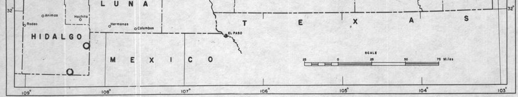
21 Grant County White Signal District - Uranium occurs in sub-ore and ore-grade at many points throughout the district, principally as autunite and torbernite occurring along quartz-pyrite veins cutting Precambrian granite. Uranium was noted as early as 1920in the district but no production has come from the district to date. Burro Mountains - Uranium mineralization is found associated with fluorite at the following properties: Langford Mine- S 25, T 22 S., R 16 W.; Hines Mine -S 34, T 21 S., R 14 W.; Purple Rock Mine - S 22, T 18 S., R 18 W. Minor amounts of autunite and uranophane are present at the Hines and Langford properties. Gold Hill District - Uranium and thorium mineralization is found associated with Precambrian pegmatite dikes. Euxenite, allanite, and samarskite have been noted. Black Hawk District -Uranium occurring possibly as pitchblende WithNi, Co, and Ag are found on the dumps of theblack Hawk and Alhambra Mines ins 20, 21, 28 and 29, T 18 S., R 16 W. Guadalupe County No occurrence of uranium mineralization has been reported from Guadalupe County. All Triassic units in the county appear to warrant particular attention. Harding County No uranium mineralization has been reported from Harding County; however, areas showing copper mineralization in the Triassic Chinle warrant particular attention. Hidalgo County An occurrence of uranium mineral has been reported from southeastern Hidalgo County - near border post No on the International Boundary. Six claims have been staked by a group of Deming people. The mineral is autunite. It occurs in massive quartz veins which are localized along a fault in lower Cretaceous limestones and sandstones (Information by Oscar Strongin, N.M.B.M.). No production has come from the deposits
22 An occurrence also has been found in the Antelope Wells area with opal occurring along a fault zone. No evaluation is possible at present. Luna County No discoveries of radioactive minerals have been reported from this county. Lea County A showing of radioactive minerals has been reported in the Cap Rock Scarp southwest of Lovington. Also a discovery has been reported from the San Simon Sink area, about 15miles west and 14 miles south of Eunice. These discoverieshave not been verified. Lincoln County Uranium and thorium mineralization is found at two points on Capitan Mountain occurring along fractures or brecciated zones in monzonite. There has not been sufficient development work for evaluation. Mora County Otero County Uranium mineralization is found with chalcocite in Permian shale and arkose in a discontinuous belt 4 to 5 miles in length near Guadalupita. The deposits have been investigated at various times during recent years by the U.S.G.S. for the A.E.C. Other "Hot Spots" are reported in the pegmatite areas in the western part of the county. Minor amounts of uranium have been found in copper workings near Orogrande.
23 Quay County Wallace Ranch - Uranium mineralization has been found at several points, principally in S 5-6, T 9 N., R 33 E., and S 28 (?), T 9 N., R 33 E. Mineralization is in the Triassic Chinle formation and occurs with carbonaceous trash and limey nodules. Carnotite-type uranium minerals and uranothorite have been noted. Troutman Ranch - Uranium mineralization is found associated with carbonized logs in sandstone of the Chinle formation in S 2, T 11 N., R 32 E. Gilstrap and Trusdel Property - Uranium mineralization is found in limonite zones in Triassic Chinle conglomerate in S 29, T 10 N., R 33 E. A large portion of the county warrants prospecting. Santa Fe County Uranium occurrences have been found at two points on the San Cristobal grant, some 8 miles south of Galisteo Village, by the A.E.C. airborne unit. Carnotite-type mineralization is found in limestone-conglomerate of the Triassic Chinle formation. Uranium mineralization reported by Griswold on the Ortiz grant is associated with carbonaceous lenses in the Tertiary Galisteo formation. Two occurrences have been found in the La Bajada area. One occurrence contains both uranium and thorium which are found in sandstone and shale. The second occurrence is related to a Tertiary andesitic sill. Some autunite is present. Uranium mineralization is found associated with small hematite lenses occurring in Permian limestone in the Truchas Range. San Miguel County Ore-grade carnotite-type uranium mineralization has been found in the Sabinoso area in sandstone, shale and conglomerate lenses in the Chinle formation. The A.E.C. airborne unit has reported several other uranium occurrences in central and extreme southeastern portions of the county. Most of these are found in the Chinle formation. Some radioactivity has also been noted in a highly altered granite zone in Gallinas Canyon, about 14 miles northwest of Las Vegas, and in many of the numerous pegmatite dikes in the western part of the county
24 Sierra County Highly radioactive materials have been found near the south end of the Caballo Mountains, southeast of the Caballo reservoir. Uranium and in places thorium mineralization occurs in interstitial chlorite and in seams and fractures in a highly altered granite mass. Some fluorspar and minor amounts of galena are present. An occurrence of pitchblende-type mineralization has been found in minor amounts along a thin shear zone in Precambrian schist at the southern limits of Truth or Consequences. Uranium mineralization has been found at the Terry Bros. property (also known as the Hanosh Prospect) near Monticello. Mineralization which includes some uranophane is found with dark purple fluorite in brecciated chert. Uranium mineralization is found at the Blanchard Hanson property on the west side of the Caballo Mountains 5 miles south of Truth or Consequences. Mineralization occurs in dark purple fluorite and includes some uranophane. Minor points of uranium mineralization occur at many other scattered points along the Caballo Mountains. Other uranium occurrences are reported from the Winston, Hermosa; Cuchillo areas, but have not been verified. Torrance County Small seams of carnotite-type ore occur in thin sandy shales and conglomerate zones of copper-bearing Permian sandstones in the area north of Scholle. Large, discontinuous zones of low uranium content extend along Priest Canyon in a belt in excess of one mile in length. The area is currently being investigated by the A.E.C. Taos Several occurrences of uranium in Precambrian pegmatite dikes have been found in the Red River area. Union County No reports of radioactive areas have been made in Union County. However, the Cap Rock country north of Capulin and Folsom, is thought to be favorable for prospecting. xxxx Lands in New Mexico, that have been withdrawn by the Atomic Energy Commission for uranium prospecting, are all located in Valencia County.They are in T 12 N, R 9 W, S 3 & 4. S 8, Lots 5, 6, 11, and 12. S 10. S 14 & 15. S 20, S 22. S 27, N½ & SW¼. S 28; NE¼NW¼, N½NE¼, and S½ S
25 LOCATION OF MINING CLAIMS IN THE STATE OF NEW MEXICO Uranium claims are staked in the same manner as lode claims. The New Mexico Statutes, 1941 require as follows: Section Mining claim - Location - Posting.notice - Record in office of county clerk. Any person or persons desiring to locate a mining claim upon a vein or lode of quartz or other rock in place bearing gold, silver, cinnabar, lead, tin, copper or other valuable deposit, must distinctly mark the location on the ground so that its boundaries may be readily traced, and post in some conspicuous place on such location, a notice in writing stating thereon the name or names of the locator or locators, his or their intention to locate the mining claim, giving a description thereof by reference to some natural object or permanent monument as will identify the claims; and also within three (3) months after posting such notice, cause to be recorded a copy thereof in the office of the clerk of the county in which the notice is posted. And Provided, no other record of such notice shall be necessary. [Laws 1876, ch. 38, Sec. 1; C.L. 1884, Sec. 1566; C.L. 1897, Sec. 2286; Code 1915, Sec. 3445; C.S. 1929, Sec ] Section Discovery shaft - Requirements. The locator or locators of any mining claim, located after this act shall take effect, shall, within ninety (90) days from the date of taking possession of the same, sink a discovery shaft upon such claim, to a depth of at least ten (10) feet from the lowest part of the rim of such shaft at the surface, exposing mineral in place, or shall drive a tunnel, adit, or open cut upon such claim, to at least ten (10) feet below the surface, exposing mineral in place. [Laws 1889, ch. 25, Sec. 1; C.L. 1897, Sec. 2298; Code 1915, Sec. 3447; C.S. 1929, Sec ] Section Boundary posts. The surface boundaries of mining claims hereafter located shall be marked by four (4) substantial posts or monuments, one (1) at each corner of such claim, so as to distinctly mark the claim on the ground, so that its boundaries can be readily traced, and shall otherwise conform to section 3445 [Section ]. [Laws 1889, ch. 25, Sec. 2; 1897, ch. 58, Sec. 6; C.L. 1897, Sec. 2299; Laws 1899, ch. 57, Sec. 1; Code 1915, Sec. 3448; C.S. 1929, Sec ] -24-
26 Section Relocation - New discovery shaft - Deepening shaft, tunnel or adit. The relocation of any mining ground, which is subject to relocation, shall be made in the same way as an original location is required by law to be made, except the relocator may either sink a new shaft upon the ground relocated to the depth of at least ten (10) feet from the lowest part of the rim of such shaft at the surface, exposing mineral in place, or drive a new tunnel, adit, or open cut upon such ground, at least ten (10) feet below the surface, exposing mineral in place, or the relocator may sink the original discovery shaft ten (10) feet deeper than it is at the time of relocation, or drive the original tunnel, adit, or open cut upon such claim, ten (10) feet further. [Laws 1889, ch. 25, Sec. 4; C.L. 1897, Sec. 2301; Code 1915, Sec. 3449;C.S. 1929, Sec ] Section Amended and additional location notices. If at any time the owner of any mining claim heretofore or hereafter located, or his assigns, shall apprehend that the original notice of location is defective, erroneous or the requirement of law has not been complied with before filing; or shall be desirous of changing his surface boundaries or to take in any part of an overlapping claim which has been abandoned, such owner may file in the office where notices of location are by law required to be filed, an amended or additional notice of location, subject to the provisions of this article. Provided, that such additional or amended notice of location does not interfere with the existing right of others at the time of filing such notice; and no such amended or additional location, or record thereof, shall preclude the claimant or his assigns from proving any such title as he or they may have held under the previous location. [Laws 1889, ch. 25, Sec. 3; C.L. 1897, Sec. 2300; Code 1915, Sec. 3450; C.S. 1929, Sec ] Section Affidavit as prima facie evidence of assessment work - Failure to file. The owner or owners of any unpatented mining claim in this state, located under the laws of the United States and of this state, shall within sixty (60) days from and after the time within which the assessment work required by law to be done upon such claim should have been done and performed, cause to be filed with the clerk of the county in which such mining claim is situated, an affidavit setting forth the time when such work was done, and the amount, character and actual cost thereof, together with the name or names of the person or persons who performed such work; and such affidavit, when made and filed as herein provided, shall be prima facie evidence of the facts therein stated. The failure to make and file such affidavit as herein provided shall, in any contest, suit or proceedings touching the title to such claim, throw the burden of proof upon the owner or owners of such claim to show that such work has been done according to law. [Laws 1897, ch. 58, Sec. 8; C.L. 1897, Sec. 2315; Code 1915, Sec. 3157; C.S. 1929, Sec ]


27


28 URANIUM IN NEW MEXICO Mines JULY 1954 o Prospects
BKLUP PRELIMINARY SUMMARY REPORT JULY 2016
 PARTICIPATED LAST MONTH TOTAL BLKUP HOURS OTHER Alamogordo PD 2 Otero 6 0 0 0 0 0 4 3 N/P Albuquerque PD 3 Bernalillo N/P Anthony PD 1 Dona Ana 4 0 0 0 0 0 3 0 Artesia PD 2 Eddy 16 0 0 0 0 3 9 0 N/P Aztec
ENGLE COAL FIELD. David E. Tabet
 OPEN FILE REPORT 115 SUMMARY OF THE GEOLOGY OF THE ENGLE COAL FIELD by David E. Tabet THE ENGLE COAL FIELD Introduction The Engle coal field (Lee, 1905), named for the small town of Engle along the Santa
New Mexico Geological Society
 New Mexico Geological Society Downloaded from: http://nmgs.nmt.edu/publications/guidebooks/33 Uranium in the Albuquerque area Virginia T. McLemore, 1982, pp. 305-311 in: Albuquerque Country II, Wells,
New Mexico Geological Society
 New Mexico Geological Society Downloaded from: http://nmgs.nmt.edu/publications/guidebooks/25 Uranium occurrences of the Nacimiento-Jemez region, Sandoval and Rio Arriba counties, New Mexico William L.
LESSONS LEARNED FROM MINING-INFLUENCED WATERS STUDIES AT THE NEW MEXICO BUREAU OF GEOLOGY AND MINERAL RESOURCES
 LESSONS LEARNED FROM MINING-INFLUENCED WATERS STUDIES AT THE NEW MEXICO BUREAU OF GEOLOGY AND MINERAL RESOURCES Virginia T. McLemore New Mexico Bureau of Geology and Mineral Resources New Mexico Institute
Virginia T. McLemore, New Mexico Bureau of Geology and Mineral Resources, New Mexico Institute of Mining and Technology, Socorro, NM 87801,
 Virginia T. McLemore, New Mexico Bureau of Geology and Mineral Resources, New Mexico Institute of Mining and Technology, Socorro, NM 87801, ginger@gis.nmt.edu U2011, Casper, Wy September 20, 2011 Acknowledgments
Amboy Iron Mines, Bristol Mountains, San Bernardino County, California. Gregg Wilkerson 2017
 Amboy Iron Mines, Bristol Mountains, San Bernardino County, California Gregg Wilkerson 2017 Acknowledgement and Disclaimer The information in this paper is taken largely from published sources. I have
Nortec Minerals announces Option to acquire 100% interest in the Cottonwood Vanadium-Uranium Project, Utah
 Nortec Minerals announces Option to acquire 100% interest in the Cottonwood Vanadium-Uranium Project, Utah Vancouver, BC / The Newswire / March 8, 2019 (the Company or Nortec ) (TSXV: NVT): Nortec announces
 Appendix C Cultural Resource Survey Findings 1. NMCRIS Activity No.: 126180 NMCRIS INVESTIGATION ABSTRACT FORM (NIAF) 2a. Lead (Sponsoring) Agency: SSCAFCA 2b. Other Permitting Agency(ies): 4. Title of
City of Six Project. Gold Mining Property in Downieville, CA. 60 Acres of Claims. Estimated Resource of over 8,800 ounces of Gold
 City of Six Project Gold Mining Property in Downieville, CA 60 Acres of Claims Estimated Resource of over 8,800 ounces of Gold Adjoining the famous Ruby Mine Property Located on a Rich Tertiary Channel
DISTRICTS, MINES, AND GEOCHEMISTRY DATABASES IN NEW MEXICO. Virginia T. McLemore and Maureen Wilks
 DISTRICTS, MINES, AND GEOCHEMISTRY DATABASES IN NEW MEXICO Virginia T. McLemore and Maureen Wilks ACKNOWLEDGEMENTS New Mexico Energy, Minerals and Natural Resource Department Company annual reports Personal
SECOND DRILL HOLE IHAD2 INTERSECTS MINERALIZED TAPLEY HILL FORMATION AND MINERALIZED BASEMENT IRON FORMATION
 Suite 304, 22 St Kilda Road St Kilda Vic 3182 Ph: +61 3 9692 7222; Fax: +61 3 9529 8057 For Immediate Release 14 th September 2007 SECOND DRILL HOLE IHAD2 INTERSECTS MINERALIZED TAPLEY HILL FORMATION AND
Characterization and comparison of mine wastes from legacy mines in NM
 Characterization and comparison of mine wastes from legacy mines in NM Presentation by: John Asafo-akowuah May 23, 2017 Overview Purpose Study Area Methodology Results Preliminary Conclusions Future Work
New Mexico Geological Society
 New Mexico Geological Society Downloaded from: http://nmgs.nmt.edu/publications/guidebooks/26 Tectonic significance of the Pony Hills, Luna County, New Mexico LeRoy L. Corbitt and Fred L. Nials, 1975,
SOUTHWEST & NORTHWEST EXPLORATION PROJECTS BINGHAM CANYON MINING DISTRICT
 SOUTHWEST & NORTHWEST EXPLORATION PROJECTS BINGHAM CANYON MINING DISTRICT SALT LAKE AND TOOELE COUNTIES, UTAH SUMMARY FRIDAY, MARCH 20, 2009 1 Tooele County Salt Lake County GOOGLE EARTH September, 2006
THE CHARACTERIZATION OF ABANDONED URANIUM MINES IN NEW MEXICO
 THE CHARACTERIZATION OF ABANDONED URANIUM MINES IN NEW MEXICO John Asafo-Akowuah 1, Virginia T. McLemore 2 1 Department of Mineral Engineering, New Mexico Tech, Socorro, NM 87801 2 New Mexico Bureau of
Petroleum possibilities of the Cuervo trough, Tucumcari Basin, New Mexico
 Petroleum possibilities of the Cuervo trough, Tucumcari Basin, New Mexico Charles B. Reynolds and Irene B. Reynolds Geological Associates, 4409 San Andres NE, Albuquerque, New Mexico 87110 Abstract One
URANIUM GEOLOGY. Uranium Fuel Cycle Conference April 27, Virginia T. McLemore
 URANIUM GEOLOGY Virginia T. McLemore New Mexico Bureau of Geology and Mineral Resources New Mexico Institute of Mining and Technology, Socorro, NM Uranium Fuel Cycle Conference April 27, 2011 Mine-life
EXISTING GEOLOGICAL INFORMATION
 CHAPER 3 EXISTING GEOLOGICAL INFORMATION 3-1 General Geology of the Surrounding Area (1) General geology and ore deposits in Mongolia Geographically, Mongolia is a country located between Russia to the
URANIUM IN THE SOCORRO AREA, NEW MEXICO
 New Mexico Geological Society Guidebook, 34th Field Conference, Socorro Region II, 1983 URANIUM IN THE SOCORRO AREA, NEW MEXICO 227 VIRGINIA T. McLEMORE New Mexico Bureau of Mines and Mineral Resources
Characterization and comparison of mine wastes from legacy mines in NM
 Characterization and comparison of mine wastes from legacy mines in NM Presentation by: John Asafo-Akowuah May 9, 2017 Overview Purpose Study Area Methodology Results Conclusions Recommendations Purpose
Prospecting Report 'S Office i DB Property, B.C. -J Negro Creek Nelson Mining District NTS 82F.050. Operator: Kootenay Gold Inc.
 . '.' I"' i9 12 Prospecting Report 'S Office i DB Property, B.C. -J Negro Creek Nelson Mining District NTS 82F.050 Operator: Kootenay Gold Inc. Owner: Darlene Lavoie Work Performed Summer of 2007 Report
Memorabilia of the Uranium Boom of the 1950 s*
 Memorabilia of the Uranium Boom of the 1950 s* Mark Wood 1 Search and Discovery Article #70125 (2012)** Posted October 8, 2012 *Adapted from oral presentation given at AAPG Rocky Mountain Section meeting,
GEOLOGY AND COPPER DEPOSITS OF THE TYRONE DISTRICT
 GEOLOGY AND COPPER DEPOSITS OF THE TYRONE DISTRICT 127 By JOSEPH KOLESSAR Phelps Dodge Corporation GEOLOGIC SETTING The Tyrone copper deposit is located in the Burro Mountains mining district in Grant
Uranium in the East Walker River Area, Lyon County Nevada GEOLOGICAL SURVEY BULLETIN 988-C
 Uranium in the East Walker River Area, Lyon County Nevada GEOLOGICAL SURVEY BULLETIN 988-C Uranium in the East Walker River Area, Lyon County Nevada By M. H. STAATZ and H. L. BAUER, Jr. A CONTRIBUTION
Virginia T. McLemore, New Mexico Bureau of Geology and Mineral Resources, New. Technology, Socorro, NM
 RARE EARTH ELEMENTS (REE) DEPOSITS IN NEW MEXICO Virginia T. McLemore, New Mexico Bureau of Geology and Mineral Resources, New Mexico Institute of Mining and Technology, Socorro, NM 87801 ginger@gis.nmt.edu
Overview of Selected Shale Plays in New Mexico*
 Overview of Selected Shale Plays in New Mexico* Ron Broadhead 1 Search and Discovery Article #10627 (2014)** Posted August 18, 2014 *Adapted from presentation at RMAG luncheon meeting, Denver, Colorado,
Geologic Map of the Hatch Quadrangle, Doña County, New Mexico
 Geologic Map of the Hatch Quadrangle, Doña County, New Mexico By William R. Seager May 1995 New Mexico Bureau of Geology and Mineral Resources Open-file Digital Geologic Map OF-GM 213 Scale 1:24,000 This
Incas Manganese Prospect, Bristol Mountains, San Bernardino County, California
 Incas Manganese Prospect, Bristol Mountains, San Bernardino County, California Gregg Wilkerson 2017 Acknowledgement and Disclaimer The information in this paper is taken largely from published sources.
Geology 12 FINAL EXAM PREP. Possible Written Response Exam Questions
 Geology 12 FINAL EXAM PREP Possible Written Response Exam Questions Use this study guide to prepare for the written response portion of the final exam. Name FINAL EXAM - POSSIBLE WRITTEN RESPONSE QUESTIONS
ASX Announcement/Media Release 11 April 2018
 20 Howard Street Perth WA 6000 PO Box Z5207 St George s Terrace ABN 66 138 145 114 Perth WA 6831 www.eonnrg.com Tel: 08 6144 0590 Fax: 08 6144 0593 ASX Code: E2E ASX Announcement/Media Release 11 April
COAU PROPERTY LEMHI COUNTY, IDAHO
 COAU PROPERTY LEMHI COUNTY, IDAHO Utah Mineral Resources 447 N 300 W, Suite 3 Kaysville, UT 84037 (801) 544-3421 ojgatten@nae-xploration.com Prepared by: North American Mine Services, LLC. March 21, 2017
TERAS FLAGSHIP CAHUILLA PROJECT
 TERAS FLAGSHIP CAHUILLA PROJECT Cahuilla Company s Main Asset is located in mining friendly Imperial County, California. Mine Development Associates completed a NI 43-101 resource report; reporting an
Glassy Rock Perlite Mine, Bristol Mountains, San Bernardino County, California
 Glassy Rock Perlite Mine, Bristol Mountains, San Bernardino County, California Gregg Wilkerson 2017 Acknowledgement and Disclaimer The information in this paper is taken largely from published sources.
THE CHARACTERIZATION OF ABANDONED URANIUM MINES (AUM) IN NEW MEXICO
 IN NEW MEXICO") THE CHARACTERIZATION OF ABANDONED URANIUM MINES (AUM) IN NEW MEXICO John Asafo-Akowuah 1 and Virginia T. McLemore 2 1 Department of Mineral Engineering, New Mexico Tech, Socorro, NM 87801 2 New Mexico
THE CHARACTERIZATION OF ABANDONED URANIUM MINES (AUM) IN NEW MEXICO John Asafo-Akowuah 1 and Virginia T. McLemore 2 1 Department of Mineral Engineering, New Mexico Tech, Socorro, NM 87801 2 New Mexico
/ h / -) S D /O I. <$il - imptecjiyid-rej) hs>c/c. J. Wallace Gwynn Assisted By -Bilt-Oalness. MINERS unuivrin TTTinnnnur n nir innr OCCURRENCES
 S D /O I. <$il - imptecjiyid-rej) hs>c/c. J. Wallace Gwynn Assisted By -Bilt-Oalness. MINERS unuivrin TTTinnnnur n nir innr OCCURRENCES") / h / -) S D /O I f CAPITOL REEF c/c MINERS unuivrin TTTinnnnur n nir innr OCCURRENCES By J. Wallace Gwynn Assisted By -Bilt-Oalness 1967 CAPITOL REEF-MINERS MOUNTAIN BITUMINOUS
/ h / -) S D /O I f CAPITOL REEF c/c MINERS unuivrin TTTinnnnur n nir innr OCCURRENCES By J. Wallace Gwynn Assisted By -Bilt-Oalness 1967 CAPITOL REEF-MINERS MOUNTAIN BITUMINOUS
Prospect Resources Signs Mining Agreement over Bucks Reef Gold Mine.
 Prospect Resources Signs Mining Agreement over Bucks Reef Gold Mine. HIGHLIGHTS Prospect Resources has secured the mining rights to the Bucks Reef Gold Mine, which lies some 600m west of its Prestwood
Mesozoic Earth History
 Mesozoic Earth History The Mesozoic Era 251-66 MYA Breakup of Pangea Changes in air and oceanic currents Evolution of new terrestrial and marine life Opening of the Atlantic Ocean Basin Rocky Mountains
MINERAL-RESOURCE POTENTIAL IN NEW MEXICO Virginia T. McLemore New Mexico Bureau of Geology and Mineral Resources, New Mexico Tech, Socorro, NM
 MINERAL-RESOURCE POTENTIAL IN NEW MEXICO 2018 Virginia T. McLemore New Mexico Bureau of Geology and Mineral Resources, New Mexico Tech, Socorro, NM Acknowledgements New Mexico Bureau of Geology and Mineral
GEOLOGY OF THE NICOLA GROUP BETWEEN MISSEZULA LAKE AND ALLISON LAKE
 GEOLOGY OF THE NICOLA GROUP BETWEEN MISSEZULA LAKE AND ALLISON LAKE (92H/15E. 10E1 By V. A. Preto INTRODUCTION Mapping was continued southward from the area covered in 1973 and an additional 55 square
Summary of Rover Metals Geologic Mapping Program at the Up Town Gold Project, Northwest Territories
 October 13, 2017 Summary of Rover Metals Geologic Mapping Program at the Up Town Gold Project, Northwest Territories Vancouver, British Columbia, Canada - Rover Metals Corp., Rover, is pleased to provide
MARKET UPDATE ON URANIUM AND GOLD PROJECTS
 ASX Announcement 1 March 2011 MARKET UPDATE ON URANIUM AND GOLD PROJECTS HIGHLIGHTS 5,000 metre drilling programme to commence at Rio Puerco uranium project within the next two weeks. Drilling to commence
Prospect Resources completes rehabilitation and mine construction at the Prestwood Gold Mine - moving into production mode
 Prospect Resources completes rehabilitation and mine construction at the Prestwood Gold Mine - moving into production mode Summary The main shaft at the Prestwood mine has been fully rehabilitated to 4
PROSPECTING REPORT. Silver Dollar Property. EVENT # TENURE # Tenure Name: GPEX Silver Dollar
 2008-2009 PROSPECTING REPORT Silver Dollar Property EVENT # 4267989 TENURE # 555462 Tenure Name: GPEX Silver Dollar Similkameen Mining Division Map 092H Central Coordinate Reference 120 06 26.9 W Longitude
SL GEOLOGY AND MINING. Coal bearing strata in the project area are referable primarily to the Allegheny Group of
 SL-145-1 GEOLOGY AND MINING Coal bearing strata in the project area are referable primarily to the Allegheny Group of Pennsylvania age. These rocks occur as dissected remnants overlying the ridge-forming
ARGENTINE FRONTIER RESOURCES INC (AFRI) SALTA EXPLORACIONES SA (SESA)
 SALTA EXPLORACIONES SA (SESA)") ARGENTINE FRONTIER RESOURCES INC (AFRI) SALTA EXPLORACIONES SA (SESA) LA SARITA IOCG-Porphyry Copper-Gold August 2006 La Sarita Cateo 2 La Sarita - bleached center is Taca Taca Arriba. The hematite zone
ARGENTINE FRONTIER RESOURCES INC (AFRI) SALTA EXPLORACIONES SA (SESA) LA SARITA IOCG-Porphyry Copper-Gold August 2006 La Sarita Cateo 2 La Sarita - bleached center is Taca Taca Arriba. The hematite zone
For personal use only
 22 April 2013 Drilling to commence at Majada, Copper-Gold Prospect, Chile. Red Gum Resources Limited (ASX: RGX, Red Gum or the Company ) is pleased to announce that drilling of its Majada Copper-Gold Prospect,
GEOLOGY, EXPLORATION, PRODUCTION HISTORY OF THE ALONG0 AND RED WASH URANIUM-VANADIUM MINES ON H.S. BEGAY S MINING PERMITS, SAN JUAN COUNTY, NEW MEXICO
 GEOLOGY, EXPLORATION, PRODUCTION HISTORY OF THE ALONG0 AND RED WASH URANIUM-VANADIUM MINES ON H.S. BEGAY S MINING PERMITS, SAN JUAN COUNTY, NEW MEXICO New Mexico Bureau of Mines and Mineral Resources Open-File
The Cobalt Rainbow. Airborne geophysical maps show that a north trending aeromagnetic high suggests further undiscovered mineralisation.
 The Cobalt Rainbow The property is located on Greenstone Creek, approximately 4.8 kilometres south west of the creek mouth. The property is located about 24 km due west of Campbell River, in the east-central
Geologic Setting and History of Mining in the Animas River Watershed, southern Colorado
 Geologic Setting and History of Mining in the Animas River Watershed, southern Colorado Virginia T. McLemore New Mexico Bureau of Geology and Mineral Resources, New Mexico Tech, Socorro, NM On August 5,
GEOLOGY Warren Mining District Idaho County, Idaho March SlI4HARY
 r?..:. F-_.,'.': t.,.. I ~ j. ii lucky BEN motp GEOLOGY Warren Mining District Idaho County, Idaho March 1984 SlI4HARY.., The Lucky Ben Croup of claims cover a gold prospect located in the Wdrren Mining
5. Environmental Analysis
 5.11 This section of the Draft Environmental Impact Report (DEIR) evaluated potential impacts to mineral resources from implementation of the General Plan. 5.11.1 Environmental Setting Minerals are defined
=%REPORT RECONNAISSANCE OF CHISHOLM LAKE PROSPECT. October 25, 1977
 =%REPORT ON FIELD RECONNAISSANCE OF CHISHOLM LAKE PROSPECT October 25, 1977 Bruce D. Vincent Imperial Oil Limited, Minerals - Coal, CALGARY, ALBERTA CHISHOLM LAKE PROSPECT Introduction The Chisholm Lake
High Grade Uranium Samples
 13 November 2007 Manager Company Announcements Company Announcements Office Australian Stock Exchange Limited Level 10, 20 Bond Street SYDNEY NSW 2000 ABN 42 082 593 235 High Grade Uranium Samples Electronic
HIGH GRADE GOLD-BEARING QUARTZ VEIN DISCOVERED AT MIAREE, KARRATHA AREA WESTERN AUSTRALIA
 17 November 2010 Company Announcements Office Australian Stock Exchange Limited 20 Bridge Street SYDNEY NSW 2000 HIGH GRADE GOLD-BEARING QUARTZ VEIN DISCOVERED AT MIAREE, KARRATHA AREA WESTERN AUSTRALIA
Geology (Mellow) Hike, Santa Lucia Memorial Park February 16, I. Overview of Santa Lucia Range geology and tectonic history
 Hike, Santa Lucia Memorial Park February 16, I. Overview of Santa Lucia Range geology and tectonic history") Geology (Mellow) Hike, Santa Lucia Memorial Park February 16, 2015 I. Overview of Santa Lucia Range geology and tectonic history A. Basement Rocks 1. Salinian Block Rocks Sierra Nevada Type, continental
Geology (Mellow) Hike, Santa Lucia Memorial Park February 16, 2015 I. Overview of Santa Lucia Range geology and tectonic history A. Basement Rocks 1. Salinian Block Rocks Sierra Nevada Type, continental
PRECAMBRIAN CRYSTALLINE AQUIFER (METAMORPHIC ROCKS)
") HAYWARD QUADRANGLE: Groundwater Production by Aquifer In the 56-square-mile area of the Hayward Quadrangle, groundwater is produced from metamorphic crystalline rocks of the Precambrian basement (in the
HAYWARD QUADRANGLE: Groundwater Production by Aquifer In the 56-square-mile area of the Hayward Quadrangle, groundwater is produced from metamorphic crystalline rocks of the Precambrian basement (in the
New Mexico Geological Society
 New Mexico Geological Society Downloaded from: http://nmgs.nmt.edu/publications/guidebooks/19 Vanadium deposits of the Placerville area, San Miguel County, Colorado R. P. Fischer, 1968, pp. 100-103 in:
Granite Weathering and Sandstone Grain Cementation in Jemez Springs, Sandoval County, New Mexico.
 Granite Weathering and Sandstone Grain Cementation in Jemez Springs, Sandoval County, New Mexico. Abstract Liz Bunin and Christine Doman The granitic basement rocks of the Jemez Springs area of Sandoval
MEMO. TO: Dennis Lapoint CC: FROM: Eriaan Wirosono DATE: April, 20 th 2014 SUBJECT: Exploration activity report March-April 2014_EW
 TO: Dennis Lapoint CC: FROM: Eriaan Wirosono DATE: April, 20 th 2014 SUBJECT: Exploration activity report March-April 2014_EW MEMO 1. Highlights and Productivity Overview pan sampling on target Areas 1
Mishi Lake Gold Property Mishibishu Lake Area, Wawa
 Mishi Lake Gold Property Mishibishu Lake Area, Wawa Location, Accessibility, Infrastructure and Local Resources The property is located 40 km west of Wawa, Ontario, in the Mishibishu Lake Area, Sault Ste.
NEW HAZELTON, OMINECA M.D.,
 PROSPECTING REPORT JUDI 1 TO 6 MINERAL CLAIMS NEW HAZELTON, OMINECA M.D., B.C. MAP 93M/4E, LAT. SS014'N, LONG. 127'33'W OWNED BY: A. L'ORSA ANTHONY L'ORSA Smithers, B.C. 21 February, 1981 TABLE OF CONTENTS
Mineral Potential of the Blue Lake Area
 Mineral Potential of the Blue Lake Area Prepared by Gregory P. Streveler and Daniel M. Mann Icy Strait Environmental Services Box 94 Gustavus, AK 99826 for The City of Sitka 6/22/09 INTRODUCTION The City
The MAPLE BAY PROJECT Copper Silver - Gold
 The MAPLE BAY PROJECT Copper Silver - Gold Good grade and tonnage potential within close proximity to Tidewater The Maple Bay Copper Silver Gold Project covers highly favourable geological host rocks of
Structural Geology Lab. The Objectives are to gain experience
 Geology 2 Structural Geology Lab The Objectives are to gain experience 1. Drawing cross sections from information given on geologic maps. 2. Recognizing folds and naming their parts on stereoscopic air
entire 1.5 meter drift width
 GOLD HILL SUMMARY In 1864 gold fever struck in the south Kootenays east of Cranbrook, British Columbia as placer gold was discovered in the Wild Horse River. What followed was everything one can imagine
Friday Project Mineral Resource Statement, Effective Date March 1, Tons (x1000)
") Friday The Friday Project is a gold property located approximately 10 miles to the south-southwest of Elk City in the Orogrande Mining District of central Idaho. The Project consists of 5 patented claims
Friday The Friday Project is a gold property located approximately 10 miles to the south-southwest of Elk City in the Orogrande Mining District of central Idaho. The Project consists of 5 patented claims
VICTORIA COPPER MINE
 THE VICTORIA COPPER MINE Elko County, Nevada USA Chuck Berg 801.947.8308 chuck.berg@coldwellutah.com CONTENTS SUMMARY... 1 LOCATION AND PROPERTY DESCRIPTION... 1 HISTORY... 3 PRODUCTION AND RESERVES...
12 tons of high-grade ore was mined from the No. 1 vein with an average grade of 13 g/t gold, 3,250 g/t silver and 23.3% lead.
 DUNWELL MINE GROUP The Dunwell Mine Group (Dunwell, Dunwell East, Bear River/MM and Silvershot properties), which includes the historic, past-producing Dunwell mine, is located 8 km northeast of Stewart
New Mexico Geological Society
 New Mexico Geological Society Downloaded from: http://nmgs.nmt.edu/publications/guidebooks/25 Structure of the Guadalupe Box area, Sandoval County, New Mexico Harvey R. DuChene, 1974, pp. 131-135 in: Ghost
1. How many unconformities exist in each column? Note that it is not the same number, necessarily, for each column!
 Geology 103 Name(s): Lab 5: Sequence stratigraphy Introduction: In the previous lab, you were able to illustrate Walther s Law by showing how transgressive rock sequences mirrored the offshore facies sequence.
Andy Wallace is a Certified Professional Geologist (CPG) with the American Institute of
 with the American Institute of") 2011 DRILLING PLANS DISCLAIMER Andy Wallace is a Certified Professional Geologist (CPG) with the American Institute of Professional Geologists and is the Qualified Person under NI 43-101 who has reviewed
2011 DRILLING PLANS DISCLAIMER Andy Wallace is a Certified Professional Geologist (CPG) with the American Institute of Professional Geologists and is the Qualified Person under NI 43-101 who has reviewed
COPPER KING GOLD COPPER PORPHYRY LARAMIE COUNTY, WYOMING
 COPPER KING GOLD COPPER PORPHYRY LARAMIE COUNTY, WYOMING Robert W. Schafer, PG 2693 State of Wyoming 15 April 2016 1 HISTORY 1881-1910 Discovery, development of Copper King underground workings. Production,
FOREWORD C. E. CHAPIN W. E. ELSTON. Frontispiece: Socorro Peak from campus of New Mexico Institute of Mining and Technology (Photo by H. L.
 .. st ^ :%''L.: FOREWORD This volume has been prepared for the spring meeting of the New Mexico Geological Society, May 17-20, 1978. Previous spring meetings of the Society have generally consisted of
NOA ASSESSMENT HARRIS QUARRY MENDOCINO COUNTY, CALIFORNIA TABLE OF CONTENTS
 NOA ASSESSMENT HARRIS QUARRY MENDOCINO COUNTY, CALIFORNIA TABLE OF CONTENTS Introduction... 1 Scope of Services... 1 Project Location and Description... 1 Geologic Setting... 1 Regional Geology... 1 Site
New Mexico Geological Society
 New Mexico Geological Society Downloaded from: http://nmgs.nmt.edu/publications/guidebooks/26 Geology of the central Organ Mountains Dona Aña County, New Mexico Thomas G. Glover, 1975, pp. 157-161 in:
ramr HHKEJ.nos "YEHT its ioiosyr
 OS6I ramr HHKEJ.nos "YEHT its ioiosyr 1 KOfiVSSITNSOOKH BiUKWaiH KOT8 1SLAHQS ITOIOOIOEf) HOIHSMI 0 ZJOOOKrdBa S3LlVJiS USGS - TEI Eept. 74-A Consisting of 5 pages Issued tog (See below) The distribution
URANIUM RESOURCES IN NEW MEXICO. Virginia T. McLemore New Mexico Bureau of Geology and Mineral Resources, New Mexico Tech, Socorro, NM
 URANIUM RESOURCES IN NEW MEXICO Virginia T. McLemore New Mexico Bureau of Geology and Mineral Resources, New Mexico Tech, Socorro, NM Purpose Describe the uranium industry in New Mexico, with emphasis
Geology of the RC Westfork Cemetery Ridge Solution Collapse Breccia, Viburnum Trend, Southeast Missouri. By Thomas Schott
 Geology of the RC Westfork Cemetery Ridge Solution Collapse Breccia, Viburnum Trend, Southeast Missouri By Thomas Schott Introduction Viburnum Trend Pb-Zn mineralization is blind Historically poor results
Northern Chile, 170 km SE of Antofagasta Centred km S-SW of the giant La Escondida Mining District (BHP Billiton & Rio Tinto)
") October 2017 Block 3-Culebra is a large property block situated along the Domeyko Cordillera porphyry copper belt in northern Chile, which is host to some of the world s largest copper deposits and mines.
October 2017 Block 3-Culebra is a large property block situated along the Domeyko Cordillera porphyry copper belt in northern Chile, which is host to some of the world s largest copper deposits and mines.
VETA GRANDE PROJECT, TETIPAC, GRO.
 VETA GRANDE PROJECT, TETIPAC, GRO. 1 INTRODUCTION Itislocatedinthenorthern portion of the state of Guerrero, in the municipality of Tetipac, in the vicinity of the village of Noxtepec, 25 km in straight
Unit 2: Geology of Tsikw aye (Mesa Prieta)
") GEOLOGIC HISTORY OF NEW MEXICO: Teacher Resource Sheet The geologic history of New Mexico is wonderfully diverse. Exposed within the state s boundaries are Precambrian igneous and metamorphic rocks more
GEOLOGIC HISTORY OF NEW MEXICO: Teacher Resource Sheet The geologic history of New Mexico is wonderfully diverse. Exposed within the state s boundaries are Precambrian igneous and metamorphic rocks more
AIRBORNE SURVEY RESULTS SUGGEST MANONO AND KITOTOLO PEGMATITES EXTEND ONTO THE BUCKELL LITHIUM PROPERTY
 Tantalex Resources Corporation 333 Bay Street, Suite 630 Toronto, ON Canada M5H 2R2 AIRBORNE SURVEY RESULTS SUGGEST MANONO AND KITOTOLO PEGMATITES EXTEND ONTO THE BUCKELL LITHIUM PROPERTY Toronto, Canada
POTENTIAL OF THE DONGWE COPPER GOLD PROJECT
 POTENTIAL OF THE DONGWE COPPER GOLD PROJECT By Nathan Sabao, P.Geo. September 2015 1 TABLE OF CONTENTS Page 1.0 EXECUTIVE SUMMARY 1 2.0 LOCATION 2 3.0 ACCESS 2 4.0 GEOLOGY 3 5.0 PREVIOUS DRILLING 5 6.0
BUREAU OF MINERAL RESOURCES GEOLOGY AND GEOPHYSICS,
 ^ ^c ^ / o/./ 3 4f c,3 COMMONWEALTH OF AUSTRALIA. DEPARTMENT OF NATIONAL DEVELOPMENT. BUREAU OF MINERAL RESOURCES GEOLOGY AND GEOPHYSICS, RECORDS. 1 960/134 GEOLOGY OF THE MAVIS TIN LEASE by P.G. Dunn.
Scadding Property Sudbury District, Ontario
 FOR IMMEDIATE RELEASE Northern Sphere Mining Corp. optimizes mineral targets on its Sudbury Nickel Belt and Arizona Porphyry Copper properties Toronto, Ontario April 5, 2018 - Northern Sphere Mining Corp.
Yellowknife Gold Project
 Yellowknife Gold Project This presentation contains forward-looking statements within the meaning of Canadian securities legislation. All statements, other than statements of historical fact, that address
LITHOLOGIC FACIES OF A PORTION OF THE STILLWATER FORMATION DON B. GOULD
 118 PROCEEDINGS OF THE OKLAHOMA a LITHOLOGIC FACIES OF A PORTION OF THE STILLWATER FORMATION DON B. GOULD University of Iowa, Iowa City, Iowa The Permian rocks of the world are noted for their unusual
Copper and Zinc Production, Disciplined Growth. S I T E V I S I T O C T O B E R % Owned Projects
 Copper and Zinc Production, Disciplined Growth. S I T E V I S I T O C T O B E R 2 0 1 6 100% Owned Projects Serbia assets Timok Magmatic Complex Rakita Joint Venture 4 exploration permits in the Bor region,
HOWE COPPER MINE PROJECT HIGH GRADE Cu-Ag with Au
 HOWE COPPER MINE PROJECT HIGH GRADE Cu-Ag with Au The Howe Copper Mine property is located approximately 55 kilometres northwest of Vancouver, BC. It is situated at 1431 metres elevation on the eastern
FIRST YEAR ASSESSMENT REPORT PROSPECTING LICENCE 16512M MARYSTOWN AREA, BURIN PENINSULA NTS 1M/3
 FIRST YEAR ASSESSMENT REPORT OF PROSPECTING ON LICENCE 16512M MARYSTOWN AREA, BURIN PENINSULA NTS 1M/3 BY NATHANIEL NOEL MSc. FOR E. MICHELE NOEL MINERAL LICENCES: 16512 M WORK CONDUCTED: MID-SEPTEMBER
Lisa Gaston NMT. Photo courtesy of Mike Williams. Matt Heizler
 Lisa Gaston NMT Photo courtesy of Mike Williams Matt Heizler Precambrian Geology Field Area 40 Ar/ 39 Ar results Do the pegmatites record intrusion ages? Conclusions Future work Precambrian provinces of
SAN LUCAS PROJECT Technical Data
 SAN LUCAS PROJECT Technical Data 1 San Lucas Overview 3km long mineralized Main Shear zone with 2 parallel vein structures identified 79 historical RC holes, ranging from about 32m-259m and averaging 158m
New Mexico Geological Society
 New Mexico Geological Society Downloaded from: http://nmgs.nmt.edu/publications/guidebooks/28 Uranium in the San Juan Basin--An overview William L. Chenoweth, 1977, pp. 257-262 in: San Juan Basin III (northwestern
PROSPECTING REPORT. Broken Hill Property. EVENT # TENURE # Tenure Name: Broken Hill. New Westminster Mining Division Map 092H
 2009-2010 PROSPECTING REPORT Broken Hill Property EVENT # 4514071 TENURE # 600988 Tenure Name: Broken Hill New Westminster Mining Division Map 092H Central Coordinate Reference 121 24 26.2 W Longitude
TECHNICAL REPORT: REGIONAL GEOLOGY AND TECTONICS Resume. Huachon Project, Cerro de Pasco departments, Peru. By: AFC Logistic SAC
 TECHNICAL REPORT: REGIONAL GEOLOGY AND TECTONICS Resume Huachon Project, Cerro de Pasco departments, Peru By: AFC Logistic SAC December 2016 1. INTRODUCTION GPM Metals Peru, in its portfolio of generating
EXPLORATION NEWS RELEASE EL GALLO EXPANDED AT DEPTH & TO THE WEST SEVERAL ZONES MERGING TOGETHER RESOURCE ESTIMATE 2 WEEKS
 June 23, 2010 EXPLORATION NEWS RELEASE EL GALLO EXPANDED AT DEPTH & TO THE WEST SEVERAL ZONES MERGING TOGETHER RESOURCE ESTIMATE 2 WEEKS TORONTO, ONTARIO (JUNE 23, 2010) US GOLD CORPORATION (NYSE Amex:
1 FILMED 1. FILE NO:!..rsrru -* -. GRAND TWO CLAIM
 FILE NO:!..rsrru -* -. GRAND TWO CLAIM REPORT ON 1993 ASSESSMENT WORK GRAND TWO CLAIM REC. NO. 301849 NELSON MINING DIVISION NTS MAP SHEET 82F6/W 49 25'51" NORTH 117 18'08" WEST 1 FILMED 1 AUTHOR: R. Jordan,
Magmatism in Western Cascades Arc. Early Tertiary Magmatism Part II. Washington Magmatism. Western Oregon. Southern Oregon
 Early Tertiary Magmatism Part II Reference: DNAG v. 3, Ch. 7, pp 294-314 Magmatism in Western Cascades Arc Active from 38 to 17 Ma New volcanic activity west of Clarno Fm and south into Oregon Western
SECTION 4 TABLES. 1 Summary of Hydrogeologic Parameters for Various Stratigraphic Units FIGURES
 SECTION 4 4.0 OVERVIEW OF GEOLOGY AND HYDROGEOLOGY... 13 4.1 Comparison of East and West Sides of Study Area... 15 4.2 Bedrock Sequence... 17 4.3 Mancos Shale (Upper Cretaceous)... 18 4.4 Mesaverde Formation