DIAMOND DRILLING. CLAIM No, HOLE No, FOOTAGE DATE NOTE NOTES: TOWNSHIP: LITTLE REPORT No, May/ 80 May X 80 June/80.
|
|
|
- Peter Park
- 5 years ago
- Views:
Transcription
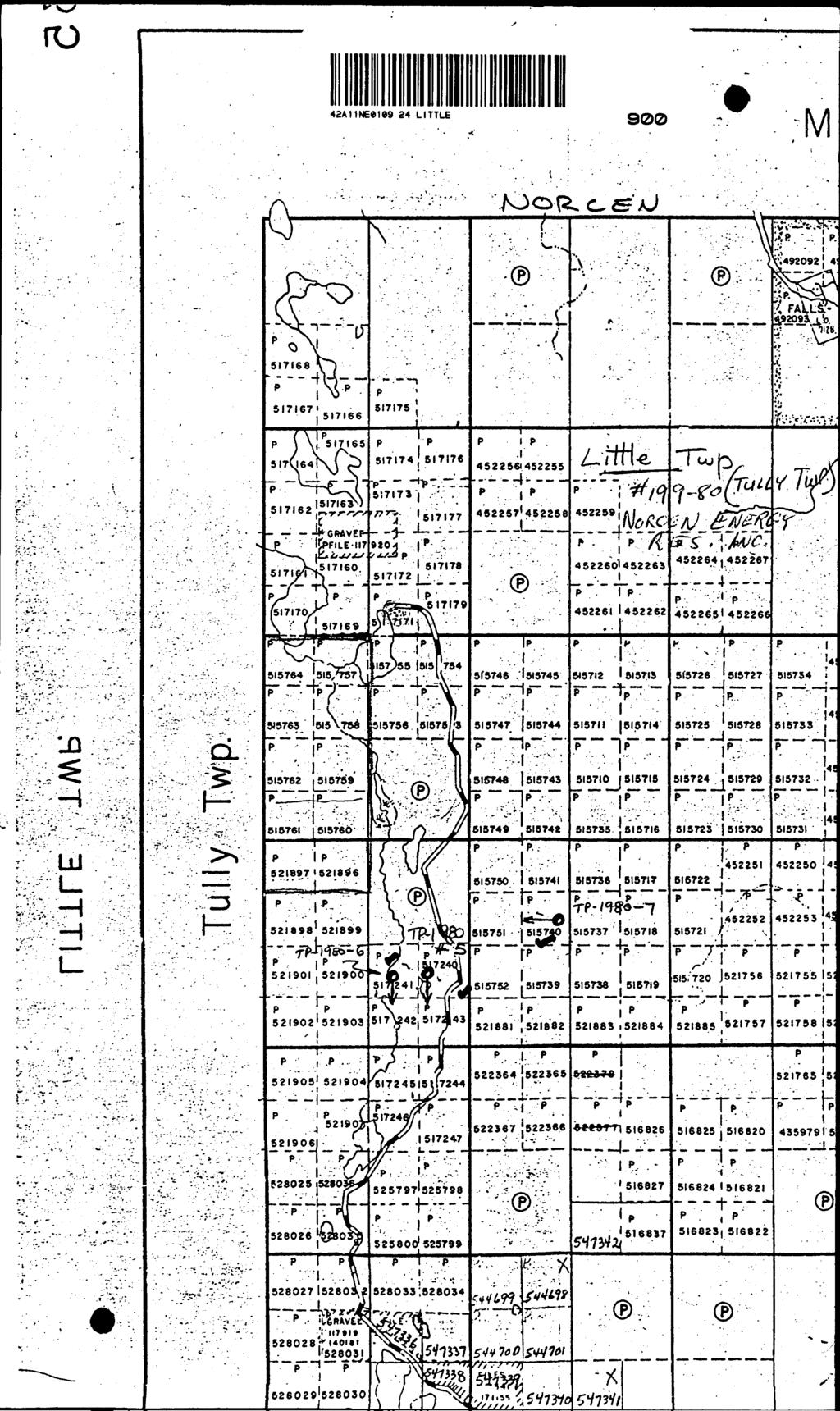
1 DIAMO DRILLING 42A11NE8ie9 24 LITTLE 010 TOWNSHIP: LITTLE REPORT No, WORK PERFORMED BY: NORCEN ENERGY RESOURCES INCORPORATED CLAIM No, HOLE No, FOOTAGE DATE NOTE P P P TP19805 TP19806 TP May/ 80 May X 80 June/80 (l) (l) (l) NOTES:
2 4 Note that 824 days of unapplied assessment credits were reported on July 14, 1980 by John Siriunas of MPH Consulting from drill hole TP These 824 days of assessment credits are hereby applied along with additional drilling credits to the above listed 127 claims. The 127 claims have 20 days assessment credit applied to each for a total of 2,540 days of credit. The remaining 9 days credit will be applied at a later date.
3 Energy Resources Limited NORCEN TOWER, 7155th Avenue S.W. CALGARY, ALBERTA T2P2X7 Phone (403) The required information is as follows: Four (4) diamond drill holes (TP19804, TP19805, TP19806 and TP19807) were drilled on this claim group. The specifications for each hole are summarized below: Hole Number Angle at Collar tal Depth Depth Casing Dates TP m (984') 39.6 m June 13, 1980 July 3, 1980 TP m, 97.5 m May 6, 1980 ' May 15, 1980 TP m (ST?') 74.4 m May 21, 1980 May 30, 1980 TP m ( 557') 82.3 m June 4, 1980 June 11, 1980 Core size for all four holes was BQ (l 7/16 m inches or 36.5 m in diameter), Drilling was performed by Bradley Bros. Ltd., Timmins, Ontario. JFG/kd

4 loionjo. TP19805 'rodfrty A 9.10 'ownship Little ocation L 500 E 225 N CXK)"d By J MS ore Location Timmins lum.irhs Length 174 m Ocarina 0 Q Dio 60" Objective COUCTOR B Grid A,9, 10 Bus Gp. DIAMO DRILL RECORD Comment 6 May 1980 ^ Completed 15 May 1980 /^ Y j/t 1 Drilling Co Bradley Bros/ /j// Core Si7e y^l ////SI Casing l ofl in Hot*. 7 A^xfsiis~~ 7 / Dip: Collar h( \^ Etch' Fest Depth Rdg. True 98.8 m 71" 64^' m O Hole No. Location Sketch IT C P" TP19805 Nprtli Clai TiNo. 51 Sea o 1" l ** ' i o' Footage Prom r OVERBURDEN, sand and large boulders D E S C R 1 P T 1 O N No. Length Cu Zn Au Ag 94.8 m 97.5 m 97.5 T 99.5 r CASING REAMED INTO BEDROCK, no core i AESITIC METAVOLCAN1C fine grained, medium green colour, chloritic partings cut by carbonate stringers at average 300 to core axis but rock is ubiguitously carbonated massive texture at start of intersection but rapidly becomes tuffaceous in appearance. The portion 98il m 99.4 m is cut by carbonatequartz veinlets subparallel to the core with some graphite associated but no sulphides though d isseminated pyrite present in host rock ^ " , m m m m DACITIC TUFF finegrained, medium green colour fainlv hard small quartz eves present trace pyrite ubiquitous carbonate and carbonate strineers GRAPHITIC CHERTY ARGILLITE black arpillite, fairly hard but graphitic along. partings sulphide (pyrite) rich at contact with preceding rock type contact at 20O at core axis brecciated and abundant auartzcarbonate stringers at lower contact * * * V. V EAK CC NIHtCTl * K""" m i DACITIC TUFF Similar in appearance to previous tuff unit (99.5 m IO3.6 m) but contains sub rounded to angular fragments and shards of black material similar in appearance to the preceding black argillite

5 "Moreen DIAMO DRILL RECORD. 273 Sheet No. ll± Footage DESCRIPTION CONTINUED: largest fragment about 10 cm and there are no fragments larger than 5 cm after m stringers of carbonate still present as well as dark string of chlorite trace disseminated pyrite as well as the occasional lens of pyrite. No.. Length Cu Zn Au m BLACK ARGILLITE narrow zone of argillite and argillaceous zones interbedded with the tuff largest zone about l cm thick but there are several other very thin bands present bedding appearance seems to indicate tops are down the hole. bedding angle still about 20 to core axis darker band of tuff overlies (?) this zone and contains wispy lenses of fine grained pyrite carbonate stringer parallels lower contact of argillite and tuff m DACITIC TUFF slmilar to previous intersection of dacitic tuff some sections are predominantly composed of crystal fragments shards and fragments of argillite are still present m rr CHERTY GRAPHITIC TUFF black argillaceous fragments with quartz, carbonate V. WE/ K CONI UCTOR graphite and probable tuffaceous material at least some of the quartz appears rather granular and may be a crystallized chert carbonate occurs subparallel to bedding (about 20 to the core axis) and at 90 to the core axis. tuffaceous material is very light grey in colour only traces of sulphide (pyrite) is present (pyrite cubes and sheens along graphitic partings) the unit is not continuous over the width of the intersection but is broken up by 0.3'm wide intervals of dacitic tuff containing stockworks of black material (graphite?) m IT DACITIC TUFF similar to previous intersections m m coarse xl and lithic tuff a few large ( l cm) buff coloured fragments, no shards of argillite observed after m, four separate beds observed, contacts at m, m contacts marked by the prcsjence of very thin bands; of^ black argillite, a brecciated appearance to the rock and the presence of buff coloured material.

6 l"**tt Kneurtct Umit*4. DIAMO DRILL RECORD Hole No TP1 980 Shoe! No. Footago ^ J n DESCRIPTION DACITIC METAVOLCANIC similar in colour to tuff, very fine grained and no evidence of tuffaceous fragments No. Length Cu Zn Au Aq 1/16.9 J r DACITIC TUFF approaching lapilli size with coarse xl and lithic fragments black shards once again present narrow quartz, breccia zone about m sulphide (pyrite) content of the rocks is still only trace quantity J 153 m GRAPHITIC TUFF dacitic tuff with stockwork of fine graphitic stringers and larger zones of quartzcarbonategraphite at low angle to core ( 10~ 20 ) from m 153 m a few cubes of pyrite are associated ~ 153 m t r r r r r 174 m. DACITIC TUFF.typical as previously described, a few zones of large xlrich sections are present possible graded bedding around m with tops indicated down the hole bedding angle still about 20" to core axis ' i DACITIC TUFF tuff appears darker in colour large block of black argillite at m, some very wispy pyrite lenses m m brecciated and contorted by late quartzcarbonate veins and vcinlcts. ' DACITIC TUFF typical intersection with zones of xlrich sections INTERBEDDED TUFFS A ARGILLITE dacitic tuffs varying from fine grained medium green to medium to light green xl tuff (good contacts between these tuffs) most argillite occurs as fragments in the tuff and as narrow strings but m 172 m s ection of very fine grained medium hardness argillite containing a fine 7, o f very fine gralnedjjyrite locally, argillite does not appear to be particularly graphitic m m another argillite band. * 2316 ^ *, m E OF HOLE

7 Norcen VJUfW limited DIAMO DRILL RECORD (lole No. oicno TP "OPt'cly A 9 T 10 ownship L i 1 1 lo :K,..on L 125 K 87.5 N wood By JMS TO Location TIMMINS emuv, Footage Prom m Length OVERBURDEN A CASING sand and gravel boulders near bedrock m' Bearing 180 Dio 65 Objective COUCTOR A Grid A9 r 10 Bus Gp. D E S C R 1 P T 1 O N Commenced 21 Mny 1 98O ^^ S~] Dip: Collar 6S O Completed 30 Mnv 1980X" /f /Si DrillingCo. Bradley B/os. /7/^/ Etch " Fest Depth Rdg. True 79.2 m O B(X^v f/ /a ' Casing Left in Hole ~S f^iss]ff2~ m 58" 49^" (A ^^(^/^^~ ^ ^c^^ f ' / X 7 No. Length Cu to C5zd.'' Location Sketch j""' Zn Au Rg North t Claim No..51*724 Scale: m DACITICRHYODACTIC VOLCANIC autobrecciated appearance, fragments appear to fit back together largest fragments. up to a few cemtimetres dark, mafix between fragments probably chloritic but may be slightly graphitic in past, bedding/foliation about 40" to axis of core, portions definitely tuffaceous looking light green colour, rare pyrite, occasional carbonate veinlet subparallel to the axis of core, gradational contact with next rock type., m 88.4 m INTERBEDDED DACITIC TUFF A ARGILLITE 2319 intimately interbedded rock types proportions of each constituent vary continuously over the length pf the intersectit n had thicknesses from mm up to 2 cm, ubiquitous carbonate in patches and,crosscuttit g microfaultcd veinlets, very chloritic along partings, some partings may be uraphitic, some tuffaceous fragments up to lapilli size occasional pyriterich bed (with up to 17. jjyrite) bedding about 45" to the axis of the core, some portions of the tuff bands are silicified or possibly cherty argillite becomes dominant towards end of intersection ^ m m ARGILLITE banded dark and lighter bands dark bands, very thin, dark green to black, very chloritic especially noticeable along partings, occasional tuff band mostly of intermediate composition and no wider than about 1 cm. Banding at 450 to the axis of the core, carbonate^ strings in variable orientations from subparallel to subperpendicular to axis of the core ^ f
 no obvious distinction between bands on fresh (broken) surface thin darker bands may be more chloritic leading to the development")
8 DIAMO DRILL RECORD TP Sheet Mn ^ Footage DESCRIPTION continued: (most subparallel though) no obvious distinction between bands on fresh (broken) surface thin darker bands may be more chloritic leading to the development of thejlaty cleavage, occasional pyrite bearing band 93.9 m 94.0 m quartzcarbonate zone subparallel to banding with associated orange earthy carbonate alteration no obvious conductors though there is the possibility of some zones/slips being graphtiic, sampled portions contain the largest pyritebearing bands No. Length n n tt * INTERMEDIATE TO FELSIC (DACITIC) TUFF with interbedded argillite tuff tuff is medium green in colour hardness is variable tuff contains mainly lithe fragments including regular shards of argillite but a few xl (feldspar) rich zones are presents, 3QZ of the intersection is argillite similar to 88.4 m m though in spokes the argillite is definitely cherty in composition, banding bedding about 30" to core axis (146.6 m) pyrite occurs up to 17. locally disseminated in tuff portions, possible' graded bedding in tuffs show tops up the hole (?) banding/bedding about 45 to axis of core (181.7 m) fragments of argillite in tuff occasional up to 2.5 cm in size with angular and subrounded portions within the same fragments fragments also show some elongation parallel to bandingbedding no obvious conductors portions of the argillite bands are brecciated and intimately mixed with the tuffs E OF HOLE... 4^

9 Hole No. TP Pronprty A 9, 10 wnship LITTLE Location L 600 N E Logged Ry JMS Corelor*tinn TIMMINS Remarks Footage m OVERBURDEN A CASING Length ^9 6^ m Bearing o Dip 60" Objective COUCTOR C Grid A9, 10 BUS Gp. DIAMO DRILL RECORD D E S C R 1 P T 1 O N Commenced ^ June 1980 /^ Djp. CjcM!tT 6 0" Completed U J" n e l^j Y J/ J DrillingCo. Bradley.Bj?6s. /X X ' EtchPest Depth Rdg. True Core Size BQ ^*jfc J/ /f~ 82.3 m O Casing Left in Hole S l/ \4 S /[LL*^ m 6 7V/." 60^7." f I ^*S^S*' (^~ s / ' No. Length Hole No.. TP19807 Location Sketch North in ' "rfp Clai n No. 5/5 740 Sea e: l" f 320' 82.3 m 89.0 m MAFIC TUFF extremely carbonated matrix and numerous crosscutting carbonate (calcite) stringers at varying orientations matrix colour variable medium green to light numerous phenocrvsts ("eves") of calcite and green to yellowish green auartz calcite eyes up to 1 cm in diameter quartz eyes up to 5 mm but average 2 3 mm dark rims occur around most of the eves and is most noticeable around the calcite eyes, quartz is usually fairly dark in colour but may occasionally be clear and show yellowish opalescence eyes from of rock foliation at about 407. to axis of the care abundant carbonate veinlets around 88.4 m 89.0 m 89.3 m QUARTZCARBONATE CEMENTED BRECCIA ZONE earthy altered pieces of quartz and carbonate with a few fragments of mafic tuff within the quartzcarbonate matrix 89.3 m m MAFIC TUFF does not contain quartz or calcite eyes some patchy carbonated zones arejresent medium green colour with numerous dark green shards) slightly chloritic on fresh (broken) to black material (rock fragments and faces matrix is slightly carbonated, foliation about 40" t n,,,, c n r *Ka. *~ 97.5 m m minor interelations of more felsic material (dacite) mostly tuffaceous in nature, some zones containing quartz and calcite eyes observed through this portion, contacts parallel to foliation m m bleached and silicified zone.. *~ 1

10 Moreen Footage J100.6 m m DIAMO DRILL RECORD Hole No.. Sheet No.. DESCRIPTION MAFIC TUFF A AGGLOMERATE iumbled assortment of various mafic tuffs with a few fragments of dacitic or rhyolitic tuff matrix was probably originally very muddy fragments subangular to roundedj probably a large amount of sedimentary reworking occasional zone of broken quartz in black (chloritic?) matrix accompanied by yellowish mineral in very thin bands/layers minor interelations of lighter coloured (mafic felsic) tuffs persist. No. Length TP m m QUARTZCARBONATE CEMENTED BRECCIA ZONE similar to 89.0 m 89.3 m thin layers of yellowish material present m bleached silicified tuff inclusion m m m m MAFIC VOLCANIC medium to dark green colour; slightly chloritic on fresh (broken) faces may be a very fine grained tuff but possible flow breccia features around m and m carbonate veinlets and stringers throughout the intersection, rock itself is not particularly carbonad MAFIC TUFF A AGGLOMERATE similar to m m, most fragments are mafic, very few could be considered dacitic, possible fragments up to 0.3 m mostly tuffaceous in nature, varying from fine to coarse grained tuff with some lapilli size. ed ^ m m MAFIC VOLCANIC similar to m m appears to definitely be more tuffaceous in nature than the previous intersection upper and lower contacts are not clear m m m MAFIC TUFF A. AGGLOMERATE similar to m m, contains a few pinkish rhyolitic angular fragments. up to 5 cm in the lower portion of the hole m m massive section m a few cherty fragments present E OF HOLE *^
11 42A1INE8ie9 24 LITTLE
Work performed by: RALPH E. ALLERSTON (NEWMONT)
") 41Pt4NE8843 24 SOTHMAN 010 Diamond Drilling Township OF SOTHMAN Report NQ; Work performed by: RALPH E. ALLERSTON (NEWMONT) Claim N9 Hole NO Footage Date Note L. 332897 L. 332898 H-l-73 H-2-73 613' 587'
41Pt4NE8843 24 SOTHMAN 010 Diamond Drilling Township OF SOTHMAN Report NQ; Work performed by: RALPH E. ALLERSTON (NEWMONT) Claim N9 Hole NO Footage Date Note L. 332897 L. 332898 H-l-73 H-2-73 613' 587'
Notes: ( i) - SEE #218/73 NOVA TWP. Township: O F BELFORD Report NQ: 18. Diamond Drilling. Claim N9. Hole NQ Footage Date. Note (D
 - SEE #218/73 NOVA TWP. Township: O F BELFORD Report NQ: 18. Diamond Drilling. Claim N9. Hole NQ Footage Date. Note (D") 42B09SWe015 18 BELFORD 010 Diamond Drilling wnship: O F BELFORD Report NQ: 18 Work performed by: AMAX POTASH Claim N9 P 312999 Hole NQ Footage Date TX-116-73 346' JULY/73 Note (D Notes: ( i) - SEE #218/73
42B09SWe015 18 BELFORD 010 Diamond Drilling wnship: O F BELFORD Report NQ: 18 Work performed by: AMAX POTASH Claim N9 P 312999 Hole NQ Footage Date TX-116-73 346' JULY/73 Note (D Notes: ( i) - SEE #218/73
Notes: Note. Township of GODSON Report NQ: 12. Diamond Dniiing. Hole NQ Footage Date. July/56. July/56. Aug/56. Aug/56. Claim NQ 487' K ' l-a
 Diamond Dniiing S2F«4NW«194 12 GODSON 010 Township of GODSON Report NQ: 12 Work performed by: KENNCO EXPLORATIONS (CANADA) LTD. Claim NQ Hole NQ Footage Date Note K 25434 l 487' July/56 l-a 48' July/56
TECK EXPLORATION LTD DIAMOND DRILL LOG
 Hole ST97-1 Sheet 1 of 8 42D9NW24 2.19129 PIC TECK EXPLORATION LTD. 1 DIAMOND DRILL LOG Job 163 H.T.S. 42 D/9 Property wnship. Claim No. Stenlund Pic wnship 18629/18622 Location: Line 923E.. Station 77N
GEOLOGICAL BRANCH ASSESSMENT REPORT
 GOLD FIELDS CANADIAN MINING, Ltd. PROPERTY FORGOLD SHEET 1 of 13 HOLE NO.FG-1 TWP Range Lot Claim No. FORGOLD-1 Coordinates Elevation 120 Core Size BQ Northing 27+. N Easting aa7.2 E Length (M) 167.03
DIAMOND DRILLING. CLAIM No, HOLE No, FOOTAGE DATE NOTE. NOTES: (i) # ios- 80 WORK PERFORMED BY: ASARCO EXPLORATION OF CANADA LIMITED
 # ios- 80 WORK PERFORMED BY: ASARCO EXPLORATION OF CANADA LIMITED") DIAMOND DRILLING 52A15NE8006 11 WOLF LAKE 010 AREA! WOLF LAKE REPORT No,: WORK PERFORMED BY: ASARCO EXPLORATION OF CANADA LIMITED CLAIM No, HOLE No, FOOTAGE DATE NOTE TB 49585H TB 495874 WR l WR 2 587.0
DIAMOND DRILLING 52A15NE8006 11 WOLF LAKE 010 AREA! WOLF LAKE REPORT No,: WORK PERFORMED BY: ASARCO EXPLORATION OF CANADA LIMITED CLAIM No, HOLE No, FOOTAGE DATE NOTE TB 49585H TB 495874 WR l WR 2 587.0
LITHOLOGY REPORT - Detailed -
 (m) (m) Lithology Sample # Length 50 0.00 11.76 10 Casing Minor Interval: 0.00 0.54 10A Casing above ground (Air) 0.54 11.76 10G Casing through gravel or overburden (Ground) 11.76 40.80 1c Interbedded
QQQ-4 QQQ-3. Apr/78 Apr/78. Diamond Drilling. Claim N9 Hole NO Footage Date Note P ,0' P ' (2) Notes: (1) #132-78
 Notes: (1) #132-78") Diamond Drilling 42B01SE0018 22 PENHORWOOD 010 Township of PENHORWOOD Report NO 22 Work performed by: Geophysical Engineering Limited Claim N9 Hole NO Footage Date Note P 504953 P 504938 QQQ-4 QQQ-3 220,0'
Diamond Drilling 42B01SE0018 22 PENHORWOOD 010 Township of PENHORWOOD Report NO 22 Work performed by: Geophysical Engineering Limited Claim N9 Hole NO Footage Date Note P 504953 P 504938 QQQ-4 QQQ-3 220,0'
: Other [ ] 309.0' 349.0' 359.0' 349.0'
![: Other [ ] 309.0' 349.0' 359.0' 349.0'](/thumbs/88/117547893.jpg ": Other [ ] 309.0' 349.0' 359.0' 349.0'") 2F68NW8ee8 26 KAWASHEGAMUK LAKE 0 DIAMOND DRILLING AREA: KAWASHEGAMUK LAKE REPORT NO: 26 WORK PERFORMED FOR: International Platinum Corporation RECORDED HOLDER: Same as above [xx] : Other [ ] Claim Hole
2F68NW8ee8 26 KAWASHEGAMUK LAKE 0 DIAMOND DRILLING AREA: KAWASHEGAMUK LAKE REPORT NO: 26 WORK PERFORMED FOR: International Platinum Corporation RECORDED HOLDER: Same as above [xx] : Other [ ] Claim Hole
-/ttr- Hor. - ill 86 A. II II II 111 li 111 DIAMOND DRILL CORE LOGGING SHEETS 9. Ol^**a. ILJJ If ^ /^jjg^jrs c DESCRIPTION ^~"~ ~.
 DIAMOND DRILL CORE LOGGING SHEETS 9 86 A PROPERTY: Solarus HOLE NO.: KL-04-01 LOCATION: Longlac LENGTH: 354.8 m PROJECT NUMBER: NORTHING: 1+40N ELEVATION: 0 UTM northing: 5514255 COLLAR ORIENTATION (AZIMUTH
DIAMOND DRILLING. CLAIM Ho. HOLE No. FOOTAGE DATE NOTE NOTES: (D # (2) # July/81 July/Bl. TOWNSHIP: Lendrum REPORT No,: 11
 # July/81 July/Bl. TOWNSHIP: Lendrum REPORT No,: 11") DIAMOND DRILLING 42C02SWe301 LENDRUM!eel LENDRUM 010 TOWNSHIP: Lendrum REPORT No,: 11 WORK PERFORMED BY: Algoma Steel Corp. CLAIM Ho. HOLE No. DATE NOTE SSM 542603-4 SSM 542596 MB-5-81 MB-7-81 309.0 703.0
DIAMOND DRILLING 42C02SWe301 LENDRUM!eel LENDRUM 010 TOWNSHIP: Lendrum REPORT No,: 11 WORK PERFORMED BY: Algoma Steel Corp. CLAIM Ho. HOLE No. DATE NOTE SSM 542603-4 SSM 542596 MB-5-81 MB-7-81 309.0 703.0
Claim NQ. Hole NO. Footage. Date. Note. Diamond Drilling. Notes: 300' T. B M Feb/73 307' T. B Feb/73 F-3 T. B.
 42E15NE8081 16 BICKLE 010 Diamond Drilling Township of Bickle Report NQ; is Work performed by: Hudson Bay Expi. e Dev't Co. Ltd, Claim NQ Hole NO Footage Date Note T. B. 33892M- 6 338925 F-l 300' Feb/73
Township of Powell Report NQ; 15
 41P15NE8376 15 POWELL 010 Diamond Drilling Township of Powell Report NQ; 15 Work performed by: British Matachewan Gold Mines Ltd. Claim N9 Hole NQ Footage Date Note M.R. 34252 2-64 1147' 1964 (D M.R. 40066
DIAMOND DRILLING DATE REPORT NO: 11 : OTHER CLAIM NO. FOOTAGE NOTE GREENBUSH LAKE WORK PERFORMED FOR: BOND GOLD CANADA INC.
 S2J16NEMee It GREENBUSH LAKE 010 DIAMOND DRILLING AREA: GREENBUSH LAKE REPORT NO: 11 WORK PERFORMED FOR: BOND GOLD CANADA INC. RECORDED HOLDER: SAME AS ABOVE : OTHER CLAIM NO. HOLE NO. FOOTAGE DATE NOTE
Diamond Drilling 42A12SE GODFREY. Report NQ 33. Work performed by: Texasgulf Limited. Claim N 0. Hole NO. Footage. Date. Notes: (1) #127-77
 #127-77") Diamond Drilling 42A12SE0416 33 GODFREY 010 Township of GODFREY Report NQ 33 Work performed by: Texasgulf Limited Claim N 0 P 410464 Hole NO G-51-2 Footage v 839,0' Date May/75 Note (1) Notes: (1) #127-77
Diamond Drilling 42A12SE0416 33 GODFREY 010 Township of GODFREY Report NQ 33 Work performed by: Texasgulf Limited Claim N 0 P 410464 Hole NO G-51-2 Footage v 839,0' Date May/75 Note (1) Notes: (1) #127-77
LITHOLOGY REPORT - Detailed -
 (m) (m) Lithology Sample # Length 50 0.00 11.00 10 Casing 0.00 0.35 10A Casing above ground (Air) 0.35 6.40 10G Casing through gravel or overburden (Ground) 6.40 11.00 10B Casing through Bedrock (Bedrock)
Area of COLLISHAW LAKE Report NO 19
 Diamond Drilling.....i mill l II l II11II III 53PI2NW00I5 S2PI2NW88I2E1 COLLISHAW LAKE 010 Area of COLLISHAW LAKE Report NO 19 Work performed by: Umex Corporation Limited Claim NO P 390911 Hole NQ Footage
PLACER DOME CANADA INC. PROPERTY: MCALPINE LAKE, ONTARIO PROJECT: #499 HOLE NO: CORE SIZE: NO. AZIMUTH: Degrees DIP: - 45 Degrees
 32L04SW0002 W9460.00060 WEST OF SUNDAY LAKE 010 PLACER DOME CANADA INC. PROPERTY: MCALPINE LAKE, ONTARIO PROJECT: #499 HOLE NO: 499-005 CORE SIZE: NO AZIMUTH: 180.00 Degrees DIP: - 45 Degrees LENGTH: 344.00
Namex Explorations Inc. Report on Drill Holes PC & PC Post Creek Property Claim S.l , Norman Township Sudbury Mining District
 . 368 4: Namex Explorations nc. Report on Drill Holes PC - 12-06 & PC -- 13-06 Post Creek Property Claim S.l 094826, Norman Township Sudbury Mining District RECEVED DEC 1 0 =:~7 ntroduction GEOSCENCf ASSESSMENT
COPPERSTONE RESOURCES AB INTERCEPTS ZONE OF CHALCOPYRITE-ARSENOPYRITE- BORNITE MINERALIZATION AT SVARTLIDEN IN FIRST DEEP DRILLHOLE FROM 720m-810m
 COPPERSTONE RESOURCES AB INTERCEPTS ZONE OF CHALCOPYRITE-ARSENOPYRITE- BORNITE MINERALIZATION AT SVARTLIDEN IN FIRST DEEP DRILLHOLE FROM 720m-810m In mid-january 2017 Copperstone Resource published a geological
DIAMOND DRILLING. TOWNSHIP: Bucke REPORT No,; 39. CLAIM No, HOLE No, FOOTAGE DATE MOTE. NOTES: (i) # S
 # S") DIAMOND DRILLING 31M85NEZ842 39 BUCKE 010 TOWNSHIP: REPORT No,; 39 WORK PERFORMED BY: Highland Crow Resources Ltd. CLAIM No, HOLE No, FOOTAGE DATE MOTE S 605275 82-7 600.0 Jan/83 (1) NOTES: (i) #23-83
DIAMOND DRILLING 31M85NEZ842 39 BUCKE 010 TOWNSHIP: REPORT No,; 39 WORK PERFORMED BY: Highland Crow Resources Ltd. CLAIM No, HOLE No, FOOTAGE DATE MOTE S 605275 82-7 600.0 Jan/83 (1) NOTES: (i) #23-83
The MAPLE BAY PROJECT Copper Silver - Gold
 The MAPLE BAY PROJECT Copper Silver - Gold Good grade and tonnage potential within close proximity to Tidewater The Maple Bay Copper Silver Gold Project covers highly favourable geological host rocks of
SECOND DRILL HOLE IHAD2 INTERSECTS MINERALIZED TAPLEY HILL FORMATION AND MINERALIZED BASEMENT IRON FORMATION
 Suite 304, 22 St Kilda Road St Kilda Vic 3182 Ph: +61 3 9692 7222; Fax: +61 3 9529 8057 For Immediate Release 14 th September 2007 SECOND DRILL HOLE IHAD2 INTERSECTS MINERALIZED TAPLEY HILL FORMATION AND
Appendix A: Core descriptions
 Appendix A: Core descriptions Core: Tan0706 1 Water Depth: 2550m Gear: Piston Date Collected: 6/5/07 Date Described: 7/12/10 Description and Comments: 0-23 (2.5Y 6/4), light yellowish brown. Sandy silt.
MEMO. TO: Dennis Lapoint CC: FROM: Eriaan Wirosono DATE: April, 20 th 2014 SUBJECT: Exploration activity report March-April 2014_EW
 TO: Dennis Lapoint CC: FROM: Eriaan Wirosono DATE: April, 20 th 2014 SUBJECT: Exploration activity report March-April 2014_EW MEMO 1. Highlights and Productivity Overview pan sampling on target Areas 1
GEOLOGY OF THE NICOLA GROUP BETWEEN MISSEZULA LAKE AND ALLISON LAKE
 GEOLOGY OF THE NICOLA GROUP BETWEEN MISSEZULA LAKE AND ALLISON LAKE (92H/15E. 10E1 By V. A. Preto INTRODUCTION Mapping was continued southward from the area covered in 1973 and an additional 55 square
RECORDED HOLDER: SAME As ABOVE [x] : OTHER [ ]
![RECORDED HOLDER: SAME As ABOVE [x] : OTHER [ ]](/thumbs/92/108372125.jpg "RECORDED HOLDER: SAME As ABOVE [x] : OTHER [ ]") DIAMOND DRILLING 4aoa9Nweei74 se PIC 010 Township: P ic Report No: 3 6 WORK PERFORMED FOR: RECORDED HOLDER: SAME As ABOVE [x] : OTHER [ ] Lytton Minerals Limited/The Ontario Paper Company Limited CLAIM
DIAMOND DRILLING 4aoa9Nweei74 se PIC 010 Township: P ic Report No: 3 6 WORK PERFORMED FOR: RECORDED HOLDER: SAME As ABOVE [x] : OTHER [ ] Lytton Minerals Limited/The Ontario Paper Company Limited CLAIM
320e4SE KEAD 010 WORK PERFORMED BY! SUPERIOR NORTHWEST INCL. HOLE No,
 DIAMOND DRILL i 320e4SE8359 18 6KEAD 010 TOWNSHIP: SKEAD REPORT No,: l8 WORK PERFORMED BY! SUPERIOR NORTHWEST INCL. CLAIM No, HOLE No, FOOTAGE DATE NOTE L 467263 SK-81-4 SK-81-5 383.0 198.5 Apr./Sl Nov./Sl
Report No; 23. Area: Resources RECORDED HOLDER: SAME As ABOVE [ x l : OTHER I l WORK PERFORMED FOR: CLAIM No, NOTES: # DIAMOND DRILLING
 DIAMOND DRILLING 42C13SE8795 23 WABIKOBA LAKE 010 Area: Wabikoba Lake WORK PERFORMED FOR: Resources RECORDED HOLDER: SAME As ABOVE [ x l : OTHER I l CLAIM No, TB 469400 HOLE No, TY-02 TY-03A FOOTAGE 439.6
VECTORING VOLCANOGENIC MASSIVE SULPHIDE MINERALIZATION AT THE RAINDROP ZONE, SNOW LAKE (NTS 63K16), MANITOBA by G.H. Gale
, MANITOBA by G.H. Gale") GS-8 VECTORING VOLCANOGENIC MASSIVE SULPHIDE MINERALIZATION AT THE RAINDROP ZONE, SNOW LAKE (NTS 63K16), MANITOBA by G.H. Gale Gale, G.H. 2002: Vectoring volcanogenic massive sulphide mineralization at
GS-8 VECTORING VOLCANOGENIC MASSIVE SULPHIDE MINERALIZATION AT THE RAINDROP ZONE, SNOW LAKE (NTS 63K16), MANITOBA by G.H. Gale Gale, G.H. 2002: Vectoring volcanogenic massive sulphide mineralization at
The Cobalt Rainbow. Airborne geophysical maps show that a north trending aeromagnetic high suggests further undiscovered mineralisation.
 The Cobalt Rainbow The property is located on Greenstone Creek, approximately 4.8 kilometres south west of the creek mouth. The property is located about 24 km due west of Campbell River, in the east-central
Work performed by: CANADIAN SUPERIOR EXPLORATION
 32E04NE0052 12 ABBOTSFORD 010 Diamond Drilling Township OF ABBOTSFORD Report NQ: 12 Work performed by: CANADIAN SUPERIOR EXPLORATION Claim M? T 92979 Hole N9 A663 Footage Date Apr/66 Note Notes: AWL.OO4
GEOLOGIC LOG. sandy. coarse-grained, dark-green autochthonous glauconite; minor amount of sand-grade shell debris, foraminifers rare
 OWNER: William E. Hackney o (Rivercliff Subdivision) DRILLER: Pittman wood & Metal Products Co. COUNTY: Nansemond (Driver) VDMR: WWCR: TOTAL DEPTH: 2092 173 607' GEOLOGIC LOG Depth in feet COLUMBIA GROUP
Earth Science Chapter 6 Rocks
 Earth Science Chapter 6 Rocks I. Rocks and the Rock Cycle * Material that makes up the solid part of the Earth. * Made of a variety of different combinations of minerals and organic matter. A. Three Major
GUIDELINES ON THE DESCRIPTION AND CLASSIFICATION OF ROCKS OF THE TUEN MUN FORMATION
 GUIDELINES ON THE DESCRIPTION AND CLASSIFICATION OF ROCKS OF THE TUEN MUN FORMATION Rod Sewell Hong Kong Geological Survey GEO/CEDD Objectives to review all known lithologies of the Tuen Mun based on literature
GEOLOGY AND LITHOGEOCHEMISTRY OF THE CHILKO-TASEKO LAKES AREA* BY G.
 B Ministry of Energy, Mines and Petroleum Resources GEOLOGICAL BRANCH MINERAL RESOURCES DIVISION NOTES TO ACCOMPANY OPEN FILE - GEOLOGY AND LITHOGEOCHEMISTRY OF THE CHILKO-TASEKO LAKES AREA* BY G. P. McLAREN
REMARKS. NANNOFOSSIL CLAYSTONE, CLAYSTONE, and CALCAREOUS SANDY SILTSTONE
 SITE 069 HOLE A CORE R CORED 78.8-78. mbsf 069A-R ACCEORIES NANNOFOIL CLAYSTONE, CLAYSTONE, and CALEOUS SANDY SILTSTONE CC AGE: middle Eocene Major Lithologies: Greenish gray (G 6/) to moderate yellowish
Sulphide Mineralisation intersected in Alcoutim Cu-Zn Project
 4 October 2017 Market Announcements Platform ASX Limited Exchange Centre 20 Bridge Street Sydney NSW 2000 Highlights Sulphide Mineralisation intersected in Alcoutim Cu-Zn Project Increasing electrical
A rock is a naturally occurring solid mixture of one or more minerals, or organic matter
 A rock is a naturally occurring solid mixture of one or more minerals, or organic matter Rocks are classified by how they are formed, their composition, and texture Rocks change over time through the rock
Observations on a Veined Section of Core Drilled at Blockhouse, Lunenburg County
 Report of Activities 2016-17 53 Observations on a Veined Section of Core Drilled at Blockhouse, Lunenburg County R. F. Mills and A. MacKay 1 The Blockhouse gold district (NTS 21A/08) lies approximately
Rock Identification Lab, 60 Points This is a BIG lab! Work carefully and thoroughly
 Rock Identification Lab, 60 Points This is a BIG lab! Work carefully and thoroughly Name: Date: Period: Lab Skills and Objectives 1. You will examine, classify, and identify several samples of igneous,
Diamond- Drill Log of Assessment Hole 200' South of north SHEET'NO. HOLE NO. l'ab94 DEPTH 203' ANQLE STP.^P- ELgVATIQKl 200' East of ANALYSIS. l.
 ! A Bayside Township THE INTERNATIONAL NIOKEL co. OF CANADA, LIMITED NE 1/4 N 1/2 Lot 2, Cone. I M..-,, 1 KI ^ orr/^r^ftr^ PROPERTY C lalm 104327 x ^-SAMPLING RECORD ^rr-r- Location Diamond- Drill Log
Name. GEOL.3250 Geology for Engineers Igneous Rocks
 Name GEOL.3250 Geology for Engineers Igneous Rocks I. Introduction The bulk of the earth's crust is composed of relatively few minerals. These can be mixed together, however, to give an endless variety
Lands Parcels in IOL CO-20
 Lands Parcels in IOL CO-20 1 CO-20 The Izok Corridor Lupin - multi-million ounce past gold production (3.6 million oz of gold at average grade of 9.3 g/t Au) Approximately 1 million ounces of undeveloped
Drill locations for the 2015 program are highlighted in the geology map below.
 2015 Exploration Program The exploration program plan at KSM for 2015 was designed to improve the understanding of block cave targets and support engineering/environmental aspects of development scenarios.
Geology, Alteration and. Petrogenesis
 The Mutooroo Copper Deposit: Geology, Alteration and Petrogenesis Graham S. Teale Consultant t Andrew T. Price Havilah Resources NL The speaker would like to thank Havilah Resources NL for the opportunity
Chapter 10. Chapter Rocks and the Rock Cycle. Rocks. Section 1 Rocks and the Rock Cycle
 Chapter 10 Rocks 1 Chapter 10 Section 1 Rocks and the Rock Cycle 2 10.1 Rocks and the Rock Cycle Magma is the parent material for all rocks. Once the magma cools and hardens, many changes can occur. Geology:
Rock Identification. invisible rhyolite andesite basalt komatiite. visible granite diorite gabbro peridotite
 Rock Identification The samples in this lab are arranged into four groups: igneous, sedimentary, metamorphic, and unknown. Study the igneous, sedimentary, and metamorphic collections to get an idea of
WEST TIMMINS MINING INC. DIAMOND DRILLING REPORT NORTHSHOREPROPERTY
 WEST TIMMINS MINING INC. DIAMOND DRILLING REPORT NORTHSHOREPROPERTY BRISTOL TOWNSHIP (G-3998) PORCUPINE MINING DIVISION, ONTARIO (DISTRICT OF COCHRANE) FOR WEST TIMMINS MINING INC. SUBMITTED BY WAYNE CORSTORPIllNE
SOUTH CERRO AZUL STRATIGRAPHIC SECTION. Upper Cerro Azul flow of the Servilleta Basalt (Tsbcau) Lower Sandlin unit (Tsl)
 Lower Sandlin unit (Tsl)") Figure A3-01 cobbles claysilt general grain size sand pebbles vf f m c vc SOUTH CERRO AZUL STRATIGRAPHIC SECTION Top at 18 m. Upper Cerro Azul flow of the Servilleta Basalt (Tsbcau) 15 Basalt: Very dark
Figure A3-01 cobbles claysilt general grain size sand pebbles vf f m c vc SOUTH CERRO AZUL STRATIGRAPHIC SECTION Top at 18 m. Upper Cerro Azul flow of the Servilleta Basalt (Tsbcau) 15 Basalt: Very dark
 19 00' N 70 20' W Loma La Cuaba volcanic edifice 70 00' W Pueblo Viejo District (location of Fig. 2) Loma Navisa volcanic edifice 69 40' W & S a m a n á B a y 0 10 20 Kilometers 18 50' N Guaimarote Hatillo
VDMR #1306 WWCR #63 TOTAL DEPTH: 10ISO" OWNER: Bayberry Estates DRILLER: J. T. Ellington COUNTY: King George (Dahlgren) GEOLOGIC LOG No sample.
 GEOLOGIC LOG No sample.") () DRILLER: J. T. Ellington COUNTY: King George (Dahlgren) VDMR WWCR #63 TOTAL DEPTH: 10ISO" GEOLOGIC LOG 0-240 No sample. Aquia Formation (240-300') 240-255 -255-270 270-285 285-300 Sand - dark-gray with
() DRILLER: J. T. Ellington COUNTY: King George (Dahlgren) VDMR WWCR #63 TOTAL DEPTH: 10ISO" GEOLOGIC LOG 0-240 No sample. Aquia Formation (240-300') 240-255 -255-270 270-285 285-300 Sand - dark-gray with
LAB 2 IDENTIFYING MATERIALS FOR MAKING SOILS: ROCK AND PARENT MATERIALS
 LAB 2 IDENTIFYING MATERIALS FOR MAKING SOILS: ROCK AND PARENT MATERIALS Learning outcomes The student is able to: 1. understand and identify rocks 2. understand and identify parent materials 3. recognize
This work follows the international standard nomenclature (IUGS) in naming the
 in naming the") CHAPTER FIVE: PETROGRAPHY This work follows the international standard nomenclature (IUGS) in naming the different Platreef rock types. It should be noted that new lithologies not described in chapter
CHAPTER FIVE: PETROGRAPHY This work follows the international standard nomenclature (IUGS) in naming the different Platreef rock types. It should be noted that new lithologies not described in chapter
CLAIM No, HOLE No, FOOTAGE DATE NOTE
 DIAMOND DRILL..,. 42Ai6seeia3 sf KERRS 010 WNSHIP! Kerrs REPORT No,; 21 WORK PERFORMED BY: Noranda Exploration Co. Ltd. CLAIM No, HOLE No, FOOTAGE DATE NOTE L 500489 177 827 496.0 496.0 Apr/82 Apr/82 (D
Liz LaRosa Images from Geology.com unless otherwise noted
 Liz LaRosa http://www.middleschoolscience.com 2010 Images from Geology.com unless otherwise noted A rock is a naturally occurring solid mixture of one or more minerals, or organic matter Rocks are classified
Igneous, Metamorphic & Sedimentary. Chapter 5 & Chapter 6
 Igneous, Metamorphic & Sedimentary Chapter 5 & Chapter 6 Section 5.1 What are Igneous Rocks? Compare and contrast intrusive and extrusive igneous rocks. Describe the composition of magma Discuss the factors
Igneous Rocks. Sedimentary Rocks. Metamorphic Rocks
 Name: Date: Igneous Rocks Igneous rocks form from the solidification of magma either below (intrusive igneous rocks) or above (extrusive igneous rocks) the Earth s surface. For example, the igneous rock
Rocks. Rocks are composed of 1 or more minerals. Rocks are classified based on how they formed (origin). 3 classes of rocks:
. 3 classes of rocks:") ROCKS Rocks If a mineral is a naturally occurring homogeneous solid, inorganically formed, with a definite chemical composi:on and a crystalline structure then what is a rock? Rocks Rocks are composed
ROCKS Rocks If a mineral is a naturally occurring homogeneous solid, inorganically formed, with a definite chemical composi:on and a crystalline structure then what is a rock? Rocks Rocks are composed
OPOSURA PROJECT, MOCTEZUMA, SONORA, MÉXICO, A HIGH GRADE ZN-PB, AG (CU, MO), ADVANCED STAGE, SKARN DEPOSIT (34) Expositor Día Hora Sala
, ADVANCED STAGE, SKARN DEPOSIT (34) Expositor Día Hora Sala") OPOSURA PROJECT, MOCTEZUMA, SONORA, MÉXICO, A HIGH GRADE ZN-PB, AG (CU, MO), ADVANCED STAGE, SKARN DEPOSIT (34) Expositor Día Hora Sala Cruz Paez Viernes 26 12:30 13:00 Sala A Cruz Enrique Paez Minera
OPOSURA PROJECT, MOCTEZUMA, SONORA, MÉXICO, A HIGH GRADE ZN-PB, AG (CU, MO), ADVANCED STAGE, SKARN DEPOSIT (34) Expositor Día Hora Sala Cruz Paez Viernes 26 12:30 13:00 Sala A Cruz Enrique Paez Minera
WEST MCARTHUR UPDATE April 17, Table 1: Winter 2018 Drill Hole Summary
 WEST MCARTHUR UPDATE April 17, 2018. Table 1: Winter 2018 Drill Hole Summary WMA044: Sooty pyrite alteration is disseminated along local beds and coats local fractures between 401.2 m and 724 metres. A
Feet. Cape May Core #51 Start depth: 240 ft Stop depth: 245 ft Recovery (ft): 5.1 ft Date: 3/21/94 Described by: JVB, KGM, CL. 5.
: 5.1 ft Date: 3/21/94 Described by: JVB, KGM, CL. 5.") SAND; medium to fine sand with abundant silt, homogenous slightly mottled appearance; mica on outside, mostly quartz; few darks; peat layer.9 - ft; cnv - same as above; the last few cores are all the same;
SAND; medium to fine sand with abundant silt, homogenous slightly mottled appearance; mica on outside, mostly quartz; few darks; peat layer.9 - ft; cnv - same as above; the last few cores are all the same;
I I I I I I I I I I I I I I I I I I I RECEIVED r 72MAY 2 3 Z008. \LL LoC:rs GEOSCIENCE ASSESSMENT OFFICE
 \LL LoC:rs - RECEVED r 72MAY 2 3 Z008 GEOSCENCE ASSESSMENT - OFFCE 2-3823 ntroduction Millstream Mines Ltd. Airport East Property Report on Drill Holes MAE - 07-01 to - 05 Claims S.1199229 & 1214977, Falconbridge
Sipa Resources Limited ABN
 Sipa Resources Limited ABN 26 009 448 980 Aims of Diamond Drilling Programme Achieved The copper sulphide chalcopyrite, intersected in each of three holes, at two locations at Enigma: best copper intersection
Sediment and sedimentary rocks Sediment
 Sediment and sedimentary rocks Sediment From sediments to sedimentary rocks (transportation, deposition, preservation and lithification) Types of sedimentary rocks (clastic, chemical and organic) Sedimentary
VAN SILVER EXPLORATIONS LTD. DRILLING REPORT. April 25, h:,*.i '... ~ ;do.
 1..- \.,I ~ ;do. 4339 VAN SILVER EXPLORATIONS LTD. DRILLING REPORT April 25, 1974. I 4939......... h:,*.i '....... -1- VAll SlVfR EXPlORfITlO~S LTD. (N. P. L.) TLLCPHONL (604) 687-4150 118-615 WEST HASTINGS
Name Class Date. Chapter 3 Rocks Chapter Test. Write the letter that best answers the question or completes the statement on the line provided.
 Chapter 3 Rocks Chapter Test Multiple Choice Write the letter that best answers the question or completes the statement on the line provided. 1. Which of the following is true about rocks? a. Rocks are
DISCOVERY OF MINERALISED PORPHYRY & MAGNETITE-COPPER-GOLD AT KAMARANGAN
 MEDUSA MINING LIMITED ABN: 60 099 377 849 Unit 7, 11 Preston Street Como WA 6152 PO Box 860 Canning Bridge WA 6153 Telephone: +618-9367 0601 Facsimile: +618-9367 0602 Email: admin@medusamining.com.au Internet:
GRAVITY WEST MINING CORP. MACKENZIE JAIMS
 GRAVITY WEST MINING CORP. MACKENZIE JAIMS REPORT ON PHASE 2 - Chief Bay Road & Drake Hill Areas DIAMOND DRILLING PROGRAM VOLTAIRE LAKE PROPERTY, DISTRICT OF THUNDER BAY, ONTARIO by Colin Bowdidge, Ph.D.,
ROCK IDENTIFICATION LAB
 ROCK IDENTIFICATION LAB What type of rock is this? Where or how is it formed? Obsidian Extrusive Igneous Rock No crystals formed Glassy Very quick cooling molten rock (lava) What type of rock is this?
rj 11 oa WESTERN MINES LIMITED Page 1 of L HOLE NO BSP i l r no 1 1NERAL RE OURCllS LOG MINERALIZATION STRUCTURE SUl FlDE INTERVAL NO
 i WESTERN MNES LMTED Page 1 of L HOLE NO BSP 81 24 FEET MRRES ROCK TYPE ALTERATON GRtf HC SAMPLE SAMPLE ASSAYS LOG MNERALZATON STRUCTURE SUl FlDE NTERVAL NO 20 40 Quartz eye plagioclase porphyry similar
CEE 437 Lecture 10 Rock Classification. Thomas Doe
 CEE 437 Lecture 10 Rock Classification Thomas Doe Igneous Origins Intrusive Batholithic or plutonic: phaneritic Dikes or sills that chill rapidly: aphanitic Extrusive deposition as melt (lava) pyroclastic
ENVI.2030L Rock Identification
 ENVI.2030L Rock Identification Name I. Introduction The bulk of the earth's crust is composed of relatively few minerals. These can be mixed together, however, to give an endless variety of rocks - aggregates
Geoloqv Assessment ReDort. Heather ProDertv. Victoria Mining Division NTS 92C/15, 16
 Litr NO: 03 04 ACTION: RO. FILE No: Geoloqv Assessment ReDort Heather ProDertv Victoria Mining Division NTS 92C/15, 16 48' 59' N Latitude 124' 30' W Longitude Owner: Minnova Inc. Operator: Minnova Inc.,
CSA Mine Observations Applied to the Development of Regional Exploration Models
 CSA Mine Observations Applied to the Development of Regional Exploration Models 1 Introduction Recent work completed by the geology team has resulted in an improved understanding of the CSA mine system
Rocks Rock- A group of minerals, glass, mineroid bound together in some way.
 Rocks Rock- A group of minerals, glass, mineroid bound together in some way. All rocks fit into one of three categories: Igneous- formed by the cooling and hardening of hot molten rock Sedimentary- formed
Petrographic Investigation of Two Float Samples from the Goldstake Property, Northern Ontario. Prepared for: Mr. Robert Dillman
 Petrographic Investigation of Two Float Samples from the Goldstake Property, Northern Ontario Prepared for: Mr. Robert Dillman by Jim Renaud Renaud Geological Consulting Ltd. 21272 Denfield Road London,
Anthill Resources Yukon - An Update on the Einarson Project
 Anthill Resources Yukon - An Update on the Einarson Project The Eastern Extension of a Carlin-type Gold Trend in the Selwyn Basin Anthill Resources Ltd Yukon Claim Holdings Over 2400 km 2 Property Location
ST ANDREW GOLDFIELDS LTD. Assessment Report. WZ Garrison Diamond Drilling Program
 ST ANDREW GOLDFIELDS LTD. Assessment Report WZ Garrison Diamond Drilling Program Garrison Township, Larder Lake Mining Division Thomas Gallo 5/6/2015 TABLE OF CONTENTS Introduction 1 Location, Access &
OWNER: Lone Star Cement Corporation DRILLER: R. L. Magette Well Drilling Corp. COUNTY: Norfolk (S. Norfolk). GEOLOGIC LOG. feet.
. GEOLOGIC LOG. feet.") Lone Star Cement Corporation DRILLER: R. L. Magette Well Drilling Corp. COUNTY: Norfolk (S. Norfolk). W: 2111 C: 165 TOTAL DEPTH: 800' GEOLOGIC LOG Depth feet in 0-40 No Samples YORKTOWN FORMATION (40-360')
Lone Star Cement Corporation DRILLER: R. L. Magette Well Drilling Corp. COUNTY: Norfolk (S. Norfolk). W: 2111 C: 165 TOTAL DEPTH: 800' GEOLOGIC LOG Depth feet in 0-40 No Samples YORKTOWN FORMATION (40-360')
Your teacher will show you a sample or diagram of each, and show you a settling column. Draw these, and label your diagrams (8 pts) Ungraded:
 Ungraded:") From Sand to Stone: How do we recognize and interpret sedimentary rocks in the rock record? (Based closely on the University of Washington ESS 101 Lab 5: Sedimentary Rocks) Introduction: This lab consists
From Sand to Stone: How do we recognize and interpret sedimentary rocks in the rock record? (Based closely on the University of Washington ESS 101 Lab 5: Sedimentary Rocks) Introduction: This lab consists
WORK PERFORMED FOR: Dome Exploration (Canada) Limited. Footage. 101m
 Limited. Footage. 101m") 52N02NW9856 26 DENT 010 DIAMOND DRILLING TOWNSHIP: DENT REPORT N0:26 WORK PERFORMED FOR: Dome Exploration (Canada) Limited RECORDED HOLDER: Same as Above [xx] : Other [ j Claim No. Hole No. Footage Date
52N02NW9856 26 DENT 010 DIAMOND DRILLING TOWNSHIP: DENT REPORT N0:26 WORK PERFORMED FOR: Dome Exploration (Canada) Limited RECORDED HOLDER: Same as Above [xx] : Other [ j Claim No. Hole No. Footage Date
I m good. Thank you.
 I m good. Thank you. The Rock Cycle Ag Earth Science Chapter 3.1 A natural occurring, inorganic crystalline material with a unique chemical composition. mineral A consolidated mixture of minerals rock
Minerals. What are minerals and how do we classify them?
 Minerals What are minerals and how do we classify them? 1 Minerals! Minerals are the ingredients needed to form the different types of rocks! Rock - is any naturally formed solid that is part of Earth
DRILL HOLE # BH-BGC13-FN-01
 DILL HOLE # BH-BGC3-FN-0 Drill Method: Mud otary/coring Depth To ock (m): N/A Page of 7 eviewed by: AJB 0 GAVEL (GW) Fine to coarse, sandy, well graded, dense, max particle size = 30 mm, angular to subrounded,
Queensland Mining Corporation Limited
 Queensland Mining Corporation Limited ABN 61 109 962 469 ASX Release 29 th July 2011 Drilling Commenced at Duck Creek Copper-Gold Project, Cloncurry, North-west Queensland Highlights RC drilling has commenced
Lab 6 - Identification of Metamorphic Rocks
 Lab 6 - Identification of Metamorphic Rocks Page - Introduction Metamorphic rocks are the third great rock group. The term meta means to change and morph means form. Metamorphic rocks are rocks who have
Review - Unit 2 - Rocks and Minerals
 Review - Unit 2 - Rocks and Minerals Base your answers to questions 1 and 2 on the diagram below, which shows the results of three different physical tests, A, B, and C, that were performed on a mineral.
(1) NOTES: d> # DIAMOND DRILLING FOOTAGE. HOLE No, CLAIM No. DATE NOTE (1) (1) (1) (1) (1) Sept/81 Sept/81 K K (1)
 NOTES: d> # DIAMOND DRILLING FOOTAGE. HOLE No, CLAIM No. DATE NOTE (1) (1) (1) (1) (1) Sept/81 Sept/81 K K (1)") DIAMOND DRILLING 52F05SW0I11 37 tx>gpm LAKE 010 AREA! Dogpaw Lake REPORT No,: 37 WORK PERFORMED BY! Noranda Exploration Co. Ltd. CLAIM No. HOLE No, FOOTAGE DATE NOTE K 489272 K 489267 K 489276 K 489270
DIAMOND DRILLING 52F05SW0I11 37 tx>gpm LAKE 010 AREA! Dogpaw Lake REPORT No,: 37 WORK PERFORMED BY! Noranda Exploration Co. Ltd. CLAIM No. HOLE No, FOOTAGE DATE NOTE K 489272 K 489267 K 489276 K 489270
Geology for Engineers Rocks
 89.325 Geology for Engineers Rocks Name I. Introduction The bulk of the earth's crust is composed of relatively few minerals. These can be mixed together, however, to give an endless variety of rocks -
(1) (1) (1) (1) (1) (1) (1) (1) (1) (1) (1) (1)
 (1) (1) (1) (1) (1) (1) (1) (1) (1) (1) (1)") DIAMOND DRILLING 31F07SW9659 IS BROUGHAM 010 TOWNSHIP! Brougham REPORT No,: i s WORK PERFORMED BY: Coronation Resources (B. Nixon Apple) CLAIM No, EO 592561 EO 592562 EO 592599 EO 592562 HOLE No, i 2 3
DIAMOND DRILLING 31F07SW9659 IS BROUGHAM 010 TOWNSHIP! Brougham REPORT No,: i s WORK PERFORMED BY: Coronation Resources (B. Nixon Apple) CLAIM No, EO 592561 EO 592562 EO 592599 EO 592562 HOLE No, i 2 3
into this.jday of Aigiist,192, (Hereinafter called the Company) (Hereinafter called the Contractor)
 (Hereinafter called the Contractor)") c. OR I L L I NG CONTRACT 1. This agreement, made and entered into this.jday of Aigiist,192, BETWE EN: AND: >ox 886, Orell CopDer M ines Ltd. Salmon Arm. B.C. (Hereinafter called the Company) Diamond M
c. OR I L L I NG CONTRACT 1. This agreement, made and entered into this.jday of Aigiist,192, BETWE EN: AND: >ox 886, Orell CopDer M ines Ltd. Salmon Arm. B.C. (Hereinafter called the Company) Diamond M
TOWNSHIP: ARNOLD REPORT NO; 18. Date Note Nov-Dec/87 (1) Footage 266' Notes: (1) IW , filed in August/88. WORK PERFORMED FOR: LAC Minerals Ltd
 Footage 266' Notes: (1) IW , filed in August/88. WORK PERFORMED FOR: LAC Minerals Ltd") 32DMNWW2, 16 ARNOLD 010 DIAMOND DRILLING TOWNSHIP: ARNOLD REPORT NO; 18 WORK PERFORMED FOR: LAC Minerals Ltd RECORDED HOLDER: Same as Above [xx] : Other [ ] Claim No. L 884017 Hole No. A14A Footage 266'
32DMNWW2, 16 ARNOLD 010 DIAMOND DRILLING TOWNSHIP: ARNOLD REPORT NO; 18 WORK PERFORMED FOR: LAC Minerals Ltd RECORDED HOLDER: Same as Above [xx] : Other [ ] Claim No. L 884017 Hole No. A14A Footage 266'
Hole 340-U1393A-1H Section 1, Top of Section: 0.0 CSF-A (m)
") Hole 4-U9A-H Section, Top of Section:. CSF-A (m) Dark volcaniclastic coarse to very coarse sand, with rare granules (up to 4 mm), mainly andesitic lava with rare carbonate grains. Similar in composition
Hole 4-U9A-H Section, Top of Section:. CSF-A (m) Dark volcaniclastic coarse to very coarse sand, with rare granules (up to 4 mm), mainly andesitic lava with rare carbonate grains. Similar in composition
GEOLOGIC REPORT. on the. NTS- 92 L/ 12 co-ords 50~37.5'~ 127~32'~ Owned by UTAH MINES LTD. GORDON MILBOURNE. Operator UTAH MINES LTD.
 GEOLOGIC REPORT on the " - SUNSET GROUP OF CLAIMS NTS- 92 L/ 12 co-ords 50~37.5'~ 127~32'~ Owned by UTAH MINES LTD. & GORDON MILBOURNE Operator UTAH MINES LTD. BY G.L. Holland Geol ogi st June 15, 1983
GEOLOGY OF THE DO27 PIPE: A PYROCLASTIC KIMBERLITE IN THE LAC DE GRAS PROVINCE, NWT, CANADA
 GEOLOGY OF THE DO27 PIPE: A PYROCLASTIC KIMBERLITE IN THE LAC DE GRAS PROVINCE, NWT, CANADA Margaret Harder 1, Casey Hetman 2, Barbara Scott Smith 3, and Jennifer Pell 1 1 Peregrine Diamonds Ltd. 2 Mineral
A. IGNEOUS Rocks formed by cooling and hardening of hot molten rock called magma (within crust or at its surface).
.") EARTH SCIENCE 11 CHAPTER 5 NOTES KEY How Earth's Rocks Were Formed Early geologists believed that the physical features of the Earth were formed by sudden spectacular events called CATASTROPHES. Modern
EARTH SCIENCE 11 CHAPTER 5 NOTES KEY How Earth's Rocks Were Formed Early geologists believed that the physical features of the Earth were formed by sudden spectacular events called CATASTROPHES. Modern
DIAMOND. RECORDED HOLDER: SAME AS ABOVE (x) : OTHER l J NCFE REPORT NO: #53 TOWNSHIP: DATE FOOTAGE HOLE NO. CLAIM NO. March 1990
 : OTHER l J NCFE REPORT NO: #53 TOWNSHIP: DATE FOOTAGE HOLE NO. CLAIM NO. March 1990") DIAMOND 52N04SWe014 53 DOME TWP 010 TOWNSHIP: REPORT NO: #53 WORK PERFORMED FOR: Outokumpu Mines ILtd. RECORDED HOLDER: SAME AS ABOVE (x) : OTHER l J CLAIM NO. HOLE NO. FOOTAGE DATE NCFE 787587 FI90-1
DIAMOND 52N04SWe014 53 DOME TWP 010 TOWNSHIP: REPORT NO: #53 WORK PERFORMED FOR: Outokumpu Mines ILtd. RECORDED HOLDER: SAME AS ABOVE (x) : OTHER l J CLAIM NO. HOLE NO. FOOTAGE DATE NCFE 787587 FI90-1
Rocks and Minerals. Tillery, Chapter 19. Solid Earth Materials
 Rocks and Minerals Tillery, Chapter 19 Science 330 Summer 2007 No other planet in the solar system has the unique combination of fluids of Earth. Earth has a surface that is mostly covered with liquid
Wind Mountain Project Summary Memo Feeder Program
 A Manex Resource Group Company Wind Mountain Project Summary Memo Feeder Program J.A. Kizis, Jr., February 07, 2018 Assays have been received for both holes drilled at Wind Mountain during late 2017 and