Ecosystem Management General Goals Subgoals
|
|
|
- Cecil Johnston
- 5 years ago
- Views:
Transcription
1 Ecosystem Management General Goals Ecosystem management integrates scientific knowledge of ecological relationships within a complex sociopolitical and values framework toward the general goal of protecting native ecosystem integrity over the long term. (The greatest good, for the greatest number, for the longest time?) Subgoals Viable populations of native species Represent ecosystem types Manage over long enough period of time to maintain evolutionary potential Allow for human use and occupancy
2 Dominant Themes Hierarchical context: Cannot work on just one level (e.g., species, population, landscape) Ecological boundaries: Management must span administrative units Ecological integrity: Native species and ecological processes for biodiversity (including natural disturbance regimes) Data collection: Habitat and species inventories; baseline characterizations Monitoring: Using data to track changes in key indicators over time. Adaptive Management: Decisions must allow learning from mistakes Interagency cooperation: Ecological boundaries requires integrating goals and procedures Organizational change: Land management agencies need to change procedures and norms Humans embedded in nature: Humans have a fundamental influence on ecological processes Values: Human values and resolving value conflict is a central task
3 Policy Barriers to Ecosystem Management Barriers 28 Federal, state, and local authorities manage parts of Yellowstone Many private landowners; interest groups like Greater Yellowstone Coalition Lack of consensus about extent of problems Lack of consensus about appropriate policy goals/value ends Missing information on ecosystem processes (including not linking together data from different agencies) Lack of interagency coordination (e.g.; agencies excluded from coordinating committees)
4 Cooperation and Ecosystem Management Factors that Could Support Cooperation Perception of common problems Trust between stakeholders Quality scientific research Perceptions of fairness Ability to resolve conflict locally Public entrepreneurs Support from Federal/State governments Belief in value of broad participation and ecological thinking

5
6 Greater Yellowstone Coordinating Committee I Basics Federal advisory committee consisting of three regional foresters, regional director of NPS, six forest supervisors, Grand Teton and Yellowstone superintendents Formulates management recommendations, but does formally control agency decision-making Implementation of management recommendations is voluntary and left to the discretion of individual land managers History (in Brief) 1964: Formed as a Memorandum of Understanding between National Park Service and Forest Service. 1985: Congressional Research Service presents report critical of interagency coordination 1987: Greater Yellowstone Area Aggregation of National Parks and National Forest Management Plans was released. 1990: Vision for the Future 1999: Winter Visitor Use Management: A Multi-agency Assessment, completed. Many other assessments and collections of data also done through 2006
7 Greater Yellowstone Coordinating Committee II Goals of Vision for Future: Conserve sense of naturalness and maintain ecosystem integrity Encourage ecological and economic sustainability Improve coordination Critics Criticized for lack of membership in terms of other federal agencies (FWS) and environmental groups; over-weighted towards USFS Process vs. substance: Criticized for lack of cooperation from multiple-use lands; all agencies oppose legislative mandate State governors were heavy critics; George Bush administration significantly rewrote and weakened Vision

8
9 Case Study: Winter Use Management Plan 1994: GYCC establishes planning team to make winter use recommendations in Greater Yellowstone Product: Winter Visitor Use Management: A Multi-agency Assessment Identifies winter use goals, existing conditions/use patterns, and potential management opportunities for each unit in Greater Yellowstone Only establishes an information basis; actual winter use rules are established in planning process of each unit Quote from Executive Summary: Each unit will independently implement winter use management, although each will be more aware of how their actions may affect another unit. Major question: To what extent does awareness of regional impacts translate into policy? What difference does the information make? Clinton admin: bans snowmobiles; Bush admin final rule allows; lots of court cases Interim Winter Use Plan allowed 720 snowmobiles per day to enter Yellowstone in 2006, w/commercial guides and best available technology (BAT) requirements for air pollution. November 20: Final Winter Use Plan released: 540 snowmobiles, with lawsuits pending


10

11 : Average snowmobile entries is 258
12

13
14 Other basic findings: Active responses more frequent as number of vehicles increases; more likely for administrative groups; elk in general more sensitive to all variables
15 The NPS does recognize a strong perception or concern, expressed in the public comments, continues to exist that snowmobiles are hurting wildlife, despite scientific evidence to the contrary. (2007 Record of Decision)
16 Yellowstone is a Class I area under CAA: Nondegradation
17 2006 Draft EIS 3B is the environmentally preferred alternative

18 2007 Final EIS
19 Case Study: Large Carnivore Conservation Challenges Costly and extensive habitat requirements Habitat suitability requirements are poorly understood (e.g., Lynx reintroduction in CO; no snowshoe hares) Competition with humans (eating livestock, and sometimes people) Limited agency budgets focused on tangible benefits Conflicts between state and Federal government (ex. Montana state legislature passing resolutions to stock Wash DC with wolves; adequacy of Wyoming wolf management plan with respect to delisting) Policy coordination Organization of participants into advocacy coalitions Carnivore conservation is surrogate for broader policy conflicts


20 Ursus arctos horrilibus Okay, this isn t a griz. But the guy in the ranger hat is the 1932 Yellowstone Park Superintendent
21 Grizzly Bear Policy: Overview The Endangered Grizzly 1975: Grizzly bear listed as threatened species in lower 48 Only 6-7 isolated subpopulations; 98% of original range gone Pre-European settlement estimates of 50,000 bears in lower 48; now there are around 1,400 About bears currently in Greater Yellowstone; some scientists recommend viable genetic population should be 3000 FWS never listed critical habitat for grizzlies (common problem) 1982 Grizzly Bear Recovery Plan; latest revision 1993 Federal listing under ESA, but DOI currently is taking public comments on rule for delisting the bear; MARCH 2007: Yellowstone population delisted Management plans of state programs in Montana, Idaho, and Wyoming and Federal lands now apply Interagency Grizzly Bear Committee Rooted in policy network created by 1973 Interagency Grizzly Bear Study Team (scientists) Created in 1983 to support implementation of Grizzly Bear Recovery Plan Consists of regional directors of USFS, NPS, FWS plus three state reps (WY, ID, MT); subcommittees
22

23 Grizzly Recovery Ecosystems
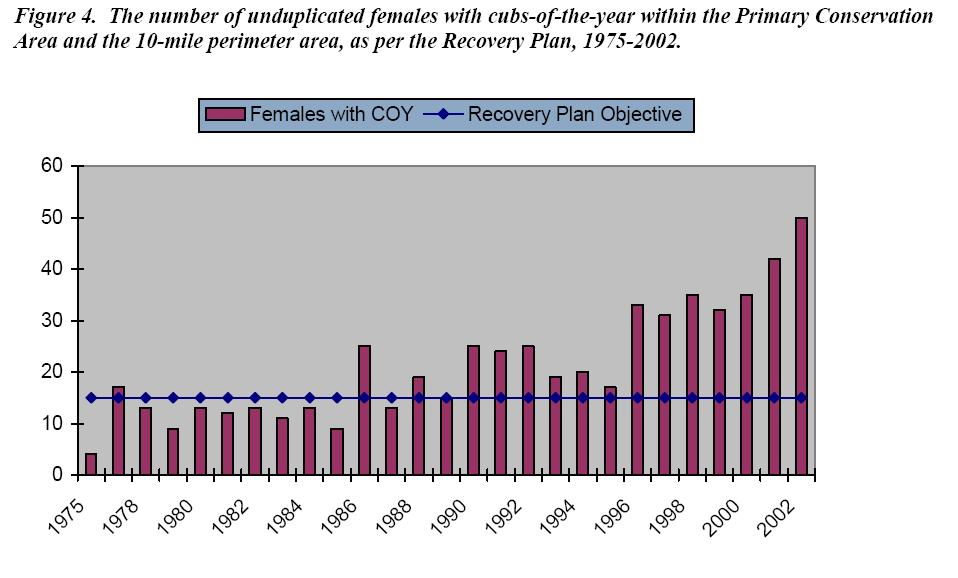
24 Grizzly Bear Recovery in Yellowstone Ecosystem Overview 2000 Conservation Strategy for Grizzly Bear in Yellowstone Area: Defines conservation strategies after possible delisting Identify Primary Conservation Area, divide PCA into bear management units Monitor grizzly populations both within PCA, and in 10-mile band outside PCA (recommendations more favorable to griz within PCA) Current estimates suggest spatial distribution of grizzlies has increased 48% since 1970, with current pop. of about 600 bears Uncertainty about possibility of habitat linkages between ecosystems Grizzly Recovery Criteria from 1993 Recovery Plan 4% limit on human-caused mortality No more than 30% of 4% can be females Confirm 15 females with cubs in total area; 6-year running average 16/18 bear management units must be occupied at least one year in six Reduce the number of human-bear conflicts (#1 cause of bear mortality) Maintain road density at 1998 levels (Roads bad for griz)
25 Bear Management Units

26 Increased Range in Greater Yellowstone
27

28 Reintroduction in Selway-Bitterroot


29 Honey, are you getting this on the video camera? Look at my Gore- Tex boots!
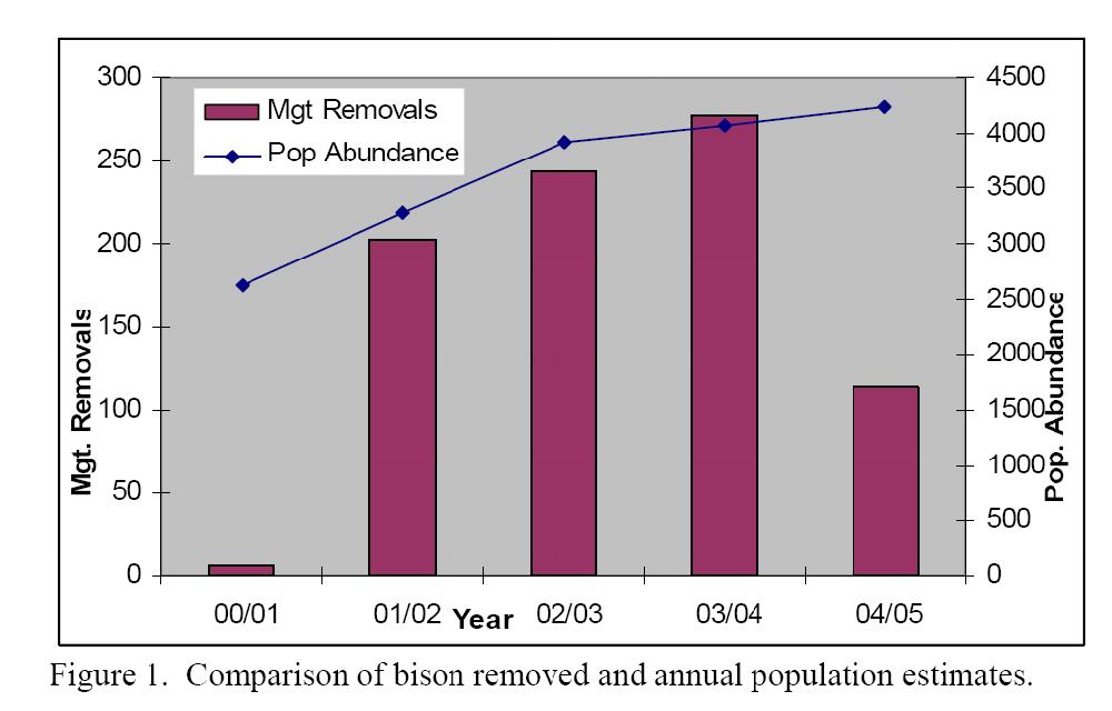
30 Case Study: Bison Management Major issue is brucellosis, which is transmitted from cattle to bison through ingestion of birth materials Long-term bison management plan began as cooperative effort between state of Montana, NPS, USFS, and disease control branch of USDA Several interim plans focused on shooting or capture/slaughter of bison leaving the park Adaptive management plan focuses on spatial and temporal separation of bison from cattle Seropositive bison outside park are captured and slaughtered Seronegative (non-infected) bison attempting to leave the park and not amenable to hazing when either the population exceeds 3,000 or exceed tolerance levels outside the park (100 bison) are removed to quarantine. If the quarantine facility is full or otherwise unavailable, they would be sent to slaughter or shot Zones define where bison are allowed, and where hazing, quarantine and lethal removal may occur (Zone 1 allows most bison; Zone 2 has bison up to specified tolerance levels; Zone 3 is the killing zone)

31 Bison Management Map
32
33 Ecosystem and Economy in Greater Yellowstone Research Questions (Thomas Michael Power) Is there really a conflict between ecosystem protection and economic welfare? How important are extractive industries to overall economic welfare? The rearview perception of economic activities Three Major Changes in GYE Economy 1. Since 1960s, proportion of economy in extractive industries declining 2. Replacement of extractive industry income by service jobs, self-employment, and non-labor income (e.g., retirement and investment dividends) 3. On GY National Forests, over 80% of jobs and economic benefits related to recreation No statistical relationship between extractive industry income and wealth in rest of economy Some of this new economic activity occurring because people moving for quality-of-life issues These trends not limited to Greater Yellowstone Ecosystem; defining economic patterns of the New West Consequences?

34

35
Background. North Cascades Ecosystem Grizzly Bear Restoration Plan/ Environmental Impact Statement. Steve Rochetta
 Grizzly Bear Restoration Plan/ Environmental Impact Statement Steve Rochetta Background Situated in the core of the North Cascades ecosystem (NCE), the North Cascades National Park Complex is surrounded
Visitor Perceptions of Roadside Bear Viewing and Management in Yellowstone National Park
 Visitor Perceptions of Roadside Bear Viewing and Management in Yellowstone National Park Leslie Richardson, Kerry Gunther, Tatjana Rosen, and Chuck Schwartz Viewing both grizzly bears (Ursus arctos) and
Project Primary Contact: Gregg Servheen, Idaho Department of Fish and Game, PO Box 25 Boise, ID ,
 Project Title: Idaho Montana Divide Project Objective: Pilot the conceptualization and coordination of a transboundary Decision Support System(DSS) for fish, wildlife, and habitats along the Idaho Montana
Wildlife and Traffic in the Carpathians
 Wildlife and Traffic in the Carpathians How to solve the problem between green and gray infrastructure Václav Hlaváč TRANSGREEN Kick-off Meeting Vienna, 28 February 2 March 2017 Nature Conservation Agency
HABITAT EFFECTIVENESS AND SECURITY AREA ANALYSES
 HABITAT EFFECTIVENESS AND SECURITY AREA ANALYSES ESGBP 194 12. HABITAT EFFECTIVENESS AND SECURITY AREA ANALYSIS Michael Gibeau As demands on the land increase, cumulative effects result from individually
Grizzly Bear Value Summary April 2016
 Grizzly Bear Value Summary April 2016 The Cumulative Effects Framework (CEF) provides statutory decision-makers and resource managers with critical information for managing cumulative effects on CEF values
Outline National legislative & policy context Regional history with ESSIM ESSIM Evaluation Phase Government Integration via RCCOM Regional ICOM Framew
 What MSP Implementation could change in the Maritimes Region Tim Hall, Regional Manager Oceans and Coastal Management Division Ecosystem Management Branch Fisheries and Oceans Canada Maritimes Region BIO
Marine Spatial Planning Leslie-Ann McGee Battelle Memorial Institute
 Marine Spatial Planning Leslie-Ann McGee Battelle Memorial Institute Rev061708 1 Marine Spatial Planning What is it? Why is it different? Where is it currently being employed? What is happening in the
THE GRIZZLY BEAR RECOVERY PROGRAM: CURRENT STATUS AND FUTURE CONSIDERATIONS ISSUES ABOUT GRIZZLY BEAR
 THE GRIZZLY BEAR RECOVERY PROGRAM: CURRENT STATUS AND FUTURE CONSIDERATIONS CHRISTOPHER SERVHEEN, U.S. Fish and Wildlife Service, University Hall, Room 308, University of Montana, Missoula, MT 59812, USA,
16540/14 EE/cm 1 DG E 1A
 Council of the European Union Brussels, 5 December 2014 (OR. en) 16540/14 ENV 965 CULT 139 NOTE From: To: Subject: General Secretariat of the Council Delegations Charter of Rome on Natural and Cultural
D2E GIS Coordination Initiative Functional Transformation Kick-Off Meeting
 D2E GIS Coordination Initiative Functional Transformation Kick-Off Meeting GIS Functional Transformation Kick-Off Meeting May 13, 2008 D2E GIS Coordination Initiative Functional Transformation Kick-Off
Statutory framework of the world network of biosphere reserves UNESCO General Conference 1996
 Statutory framework of the world network of biosphere reserves UNESCO General Conference 1996 Keywords: conservation, protected areas, biosphere reserves, policies, strategies. For the Mountain Forum's
Statutory Framework of Biosphere Reserves. The Statutory Framework of the World Network of Biosphere Reserves
 Page 1 of 5 The Statutory Framework of the World Network of Biosphere Reserves Introduction Article 1 - Definition Article 2 - World Network of Biosphere Reserves Article 3 - Functions Article 4 - Criteria
Al Ain Cultural Heritage Management Strategy 1/102
 AL AIN CULTURAL HERITAGE MANAGEMENT STRATEGY EXECUTIVE SUMMARY The cultural heritage of Al Ain is rich and varied; it consists of tangible and intangible resources and incorporates archaeological sites,
THE SEVILLE STRATEGY ON BIOSPHERE RESERVES
 THE SEVILLE STRATEGY ON BIOSPHERE RESERVES 1 VISION FOR BIOSPHERE RESERVES IN THE 21 ST CENTURY The international Seville Conference on Biosphere Reserves, organised by UNESCO, adopted a two-pronged approach,
The National Spatial Strategy
 Purpose of this Consultation Paper This paper seeks the views of a wide range of bodies, interests and members of the public on the issues which the National Spatial Strategy should address. These views
IN THE UNITED STATES DISTRICT COURT FOR THE DISTRICT OF MONTANA MISSOULA DIVISION. No.
 Matthew K. Bishop (Mont. Bar No. 9968) Western Environmental Law Center 103 Reeder s Alley Helena, Montana 59603 Tel: 406-324-8011 bishop@westernlaw.org John R. Mellgren, application for pro hac vice pending
Land Use in the context of sustainable, smart and inclusive growth
 Land Use in the context of sustainable, smart and inclusive growth François Salgé Ministry of sustainable development France facilitator EUROGI vice president AFIGéO board member 1 Introduction e-content+
IUCN Red List Process. Cormack Gates Keith Aune
 IUCN Red List Process Cormack Gates Keith Aune The IUCN Red List Categories and Criteria have several specific aims to provide a system that can be applied consistently by different people; to improve
Priority areas for grizzly bear conservation in western North America: an analysis of habitat and population viability INTRODUCTION METHODS
 Priority areas for grizzly bear conservation in western North America: an analysis of habitat and population viability. Carroll, C. 2005. Klamath Center for Conservation Research, Orleans, CA. Revised
WELCOME & INTRODUCTION
 MPA Management Capacity Building Training Module 1: WELCOME & INTRODUCTION Participants Distinguished Guests Welcome Site Overviews of MPAs represented Overview of Training Program What are Today s Objectives?
Bombing for Biodiversity in the United States: Response to Zentelis & Lindenmayer 2015
 CORRESPONDENCE Bombing for Biodiversity in the United States: Response to Zentelis & Lindenmayer 2015 Jocelyn L. Aycrigg 1, R. Travis Belote 2, Matthew S. Dietz 3, Gregory H. Aplet 4, & Richard A. Fischer
HELSINKI COMMISSION Baltic Marine Environment Protection Commission
 HELSINKI COMMISSION Baltic Marine Environment Protection Commission HELCOM RECOMMENDATION 24/10 Adopted 25 June 2003, having regard to Article 20, Paragraph 1 b) of the 1992 Helsinki Convention IMPLEMENTATION
National Land Use Policy and National Integrated Planning Framework for Land Resource Development
 Title National Land Use Policy and National Integrated Planning Framework for Land Resource Development Duration: 32 Weeks Objective: Adoption of appropriate land use planning approaches to: Maintain the
An Introduction to Day Two. Linking Conservation and Transportation Planning Lakewood, Colorado August 15-16, 16, 2006
 An Introduction to Day Two Linking Conservation and Transportation Planning Lakewood, Colorado August 15-16, 16, 2006 1 Agenda Day One Transportation Planning Heritage Program State Wildlife Action Plan
TOWARDS CLIMATE-RESILIENT COASTAL MANAGEMENT: OPPORTUNITIES FOR IMPROVED ICZM IN BELIZE
 TOWARDS CLIMATE-RESILIENT COASTAL MANAGEMENT: OPPORTUNITIES FOR IMPROVED ICZM IN BELIZE CHANTALLE SAMUELS Coastal Zone Management Authority and Institute The Caribbean Community Climate Change Centre VULNERABILITY
Spatial Decision-Support for National Marine Conservation Areas in the Southern Strait of Georgia and Gwaii Haanas
 Spatial Decision-Support for National Marine Conservation Areas in the Southern Strait of Georgia and Gwaii Haanas Lindsay McBlane Krista Royle Greg MacMillan Photo: Mark Hiebert Western and Northern Service
US National Spatial Data Infrastructure A Spatial Framework for Governance and Policy Development to Enable a Location-Based Digital Ecosystem
 GeoPlatform Workshop 7 Dec 2016, Department of the Interior Washington, D.C. US National Spatial Infrastructure A Spatial Framework for Governance and Policy Development to Enable a Location-Based Digital
AVALANCHE FORECASTER EXCHANGE PROGRAM U.S. SWITZERLAND
 AVALANCHE FORECASTER EXCHANGE PROGRAM U.S. SWITZERLAND Matt Hill* Mount Shasta Avalanche Center, USDA Forest Service, Mt. Shasta City, CA, U.S.A. Thomas Wiesinger Swiss Federal Institute for Snow and Avalanche
Marine/Maritime Spatial Planning Andrej Abramić
 Marine/Maritime Spatial Planning Andrej Abramić EcoAqua SUMMER SCHOOL: Ecosystem approach to aquaculture 26-29th of October 2015 Research and Technology to enhance excellence in Aquaculture development
Bengt Kjellson Chair of the Executive Committee UN-GGIM: Europe. 2 nd Joint UN-GGIM: Europe ESS Meeting 11 th March 2016, Luxembourg
 Bengt Kjellson Chair of the Executive Committee UN-GGIM: Europe 2 nd Joint UN-GGIM: Europe ESS Meeting 11 th March 2016, Luxembourg A global geospatial mandate At its 47th plenary in July 2011, ECOSOC,
Urbanization and Sustainable Development of Cities: A Ready Engine to Promote Economic Growth and Cooperation
 Urbanization and Sustainable Development of Cities: A Ready Engine to Promote Economic Growth and Cooperation Wan Portia Hamzah Institute of Strategic and International Studies (ISIS) Malaysia 10 September
What s the problem? A Modern Odyssey in Search of Relevance. The search for relevance. Some current drivers for new services. Some Major Applications
 A Modern Odyssey in Search of Relevance FIG Working Week, Athens, 24 May 2004 Paul Kelly ANZLIC Executive Director The search for relevance 1. New expectations for spatial services 2. Are we ready to meet
Annex I. Common criteria for the choice of Protected Marine and Coastal Areas that could be included in SPAMI list
 Annex I Common criteria for the choice of Protected Marine and Coastal Areas that could be included in SPAMI list PROTOCOL CONCERNING SPECIALLY PROTECTED AREAS AND BIOLOGICAL DIVERSITY IN THE MEDITERRANEAN
Introduction and Project Overview
 Greater New Orleans Regional Land Use Modeling GIS Techniques in a P olitical C ontext Louisiana Remote Sensing and GIS Workshop Wednesday, April 24, 2013 Working Towards a Shared Regional Vision Introduction
Study Overview. the nassau hub study. The Nassau Hub
 Livable Communities through Sustainable Transportation the nassau hub study AlternativeS analysis / environmental impact statement The Nassau Hub Study Overview Nassau County has initiated the preparation
U.S. Geological Survey Agency Briefing for MAPPS Mark L. DeMulder Director, National Geospatial Program. March 12, 2013
 + U.S. Geological Survey Agency Briefing for MAPPS Mark L. DeMulder Director, National Geospatial Program March 12, 2013 + 3D Elevation Program (3DEP) National Leadership The National Enhanced Elevation
Population Trends Along the Coastal United States:
 Coastal Trends Report Series Population Trends Along the Coastal United States: 1980-2008 U.S. Department of Commerce National Oceanic and Atmospheric Administration National Ocean Service Assessing the
Marine Spatial Planning: A Tool for Implementing Ecosystem-Based Management
 Marine Spatial Planning: A Tool for Implementing Ecosystem-Based Management Steven Murawski, Ph.D., Ecosystem Goal Team Lead National Oceanic and Atmospheric Administration NOAA November 16, 2009 1 To
13.1. Ecologists Study Relationships. Ecologists study environments at different levels of organization.
 13.1 Ecologists Study Relationships VOCABULARY ecology community ecosystem biome KEY CONCEPT Ecology is the study of the relationships among organisms and their environment. Main Ideas Ecologists study
Proposed Scope of Work Village of Farmingdale Downtown Farmingdale BOA Step 2 BOA Nomination Study / Draft Generic Environmental Impact Statement
 Proposed Scope of Work Village of Farmingdale Downtown Farmingdale BOA Step 2 BOA Nomination Study / Draft Generic Environmental Impact Statement The scope of work that follows incorporates and covers
Safety Guidelines for the Chemistry Professional: Understanding Your Role and Responsibilities
 Safety Guidelines for the Chemistry Professional: Understanding Your Role and Responsibilities Kenneth P. Fivizzani Committee on Chemical Safety/ Division of Chemical Health & Safety August 22, 2017 Introduction
Foundation Geospatial Information to serve National and Global Priorities
 Foundation Geospatial Information to serve National and Global Priorities Greg Scott Inter-Regional Advisor Global Geospatial Information Management United Nations Statistics Division UN-GGIM: A global
Overcoming Complexities on the Interface of Infrastructure and Land Use
 Date 22-11-2013 1 Overcoming Complexities on the Interface of Infrastructure and Land Use Towards design preconditions for integrated regional development Niels Heeres & Jos Arts University of Groningen,
Local Area Key Issues Paper No. 13: Southern Hinterland townships growth opportunities
 Draft Sunshine Coast Planning Scheme Review of Submissions Local Area Key Issues Paper No. 13: Southern Hinterland townships growth opportunities Key Issue: Growth opportunities for Southern Hinterland
GIS Geographical Information Systems. GIS Management
 GIS Geographical Information Systems GIS Management Difficulties on establishing a GIS Funding GIS Determining Project Standards Data Gathering Map Development Recruiting GIS Professionals Educating Staff
CEMAT results - over the years
 CEMAT results - over the years Technical Conference on Functional Areas capitalization of local potential within the territorial development policies in Europe European Conference of Ministers responsible
Indicator : Average share of the built-up area of cities that is open space for public use for all, by sex, age and persons with disabilities
 Goal 11: Make cities and human settlements inclusive, safe, resilient and sustainable Target 11.7: By 2030, provide universal access to safe, inclusive and accessible, green and public spaces, in particular
Geography - Grade 8. Unit A - Global Settlement: Patterns and Sustainability
 Geography - Grade 8 Geographical Thinking: Spatial Significance Patterns and Trends Interrelationships Geographic Perspective Geographic Inquiry: STEP 1 - Formulate Questions STEP 2 - Gather and Organize
SPLAN-Natura Towards an integrated spatial planning approach for Natura th January, 2017 Brussels. Commissioned by DG Environment
 SPLAN-Natura 2000 Towards an integrated spatial planning approach for Natura 2000 Commissioned by DG Environment 17 th January, 2017 Brussels V. Simeonova (Ph.D.) Drivers towards integrating Biodiversity
15 March 2010 Re: Draft Native Vegetation of the Sydney Metropolitan Catchment Management Authority Area GIS layers and explanatory reports
 SYDNEY COASTAL COUNCILS GROUP Inc. C/- City of Sydney Council Level 14, 456 Kent Street GPO Box 1591, SYDNEY NSW 2001 Phone: (02) 9246 7791 Facsimile: (02) 9265 9660 Email: info@sydneycoastalcouncils.com.au
Bear Conservation. Recolonization. Reintroduction IDENTIFYING POTENTIAL COLONIZATION PATTERNS FOR REINTRODUCED BLACK BEAR POPULATIONS
 IDENTIFYING POTENTIAL COLONIZATION PATTERNS FOR REINTRODUCED BLACK BEAR POPULATIONS Jared Laufenberg Department of Forestry, Wildlife and Fisheries University of Tennessee Bear Conservation Distribution
Community participation in sustainable tourism - A case study of two indigenous communities
 Po-Hsin Lai Department of Park, Recreation, and Tourism Sciences Texas A&M University Community participation in sustainable tourism - A case study of two indigenous communities Community participation
Management Planning & Implementation of Communication Measures for Terrestrial Natura 2000 Sites in the Maltese Islands Epsilon-Adi Consortium
 Management Planning & Implementation of Communication Measures for Terrestrial Natura 2000 Sites in the Maltese Islands Epsilon-Adi Consortium Briefing Meetings, February 2013 CT3101/2011, MEPA, Malta
LOUISIANA STUDENT STANDARDS FOR SOCIAL STUDIES THAT CORRELATE WITH A FIELD TRIP TO DESTREHAN PLANTATION KINDERGARTEN
 LOUISIANA STUDENT STANDARDS FOR SOCIAL STUDIES THAT CORRELATE WITH A FIELD TRIP TO DESTREHAN PLANTATION KINDERGARTEN Standard 2 Historical Thinking Skills Students distinguish between events, people, and
9. Parashant Dark Sky Park Light Management Plan (LMP)
") 9. Parashant Dark Sky Park Light Management Plan (LMP) Introduction: Grand Canyon-Parashant National Monument encompasses over a million acres, including joint federal agencies, Arizona state lands, and
9. Parashant Dark Sky Park Light Management Plan (LMP) Introduction: Grand Canyon-Parashant National Monument encompasses over a million acres, including joint federal agencies, Arizona state lands, and
Key Indicators for Territorial Cohesion & Spatial Planning Stakeholder Workshop - Project Update. 13 th December 2012 San Sebastián, Basque Country
 Key Indicators for Territorial Cohesion & Spatial Planning Stakeholder Workshop - Project Update 13 th December 2012 San Sebastián, Basque Country Key Aims Explore the use of territorial data in developing
Creating A-16 Compliant National Data Theme for Cultural Resources
 Creating A-16 Compliant National Data Theme for Cultural Resources Cultural Resource GIS Facility National Park Service John J. Knoerl Deidre McCarthy Paper 169 Abstract OMB Circular A-16 defines a set
Introduction to Geographic Information Systems
 Introduction to Geographic Information Systems What is GIS? GIScience, Geography and Cartography GIS Maps Why is it important? What is Driving GIS? Applications of GIS Case Studies Components of a GIS
Mapping Maine s Working Waterfront: for Our Heritage and Economy
 Mapping Maine s Working Waterfront: for Our Heritage and Economy Abstract Mapping Maine s Working Waterfronts is a collaborative project led by the Island Institute that inventories the state s current
Role of SF-MST. A summary of SF-MST
 A summary of SF-MST UNWTO Committee on Statistics and TSA Madrid, 27 & 28 February 2018 Carl Obst, IDEEA Group Consultant to UNWTO Role of SF-MST Respond to the significant demand for robust measures of
Haida Gwaii Queen Charlotte Islands
 Haida Gwaii Queen Charlotte Islands H E R I T A G E T O U R I S M STRATE GY January 2003 Haida Gwaii/Queen Charlotte Islands Heritage Tourism Strategy Working Group The Haida Gwaii/Queen Charlotte Islands
Land Accounts - The Canadian Experience
 Land Accounts - The Canadian Experience Development of a Geospatial database to measure the effect of human activity on the environment Who is doing Land Accounts Statistics Canada (national) Component
Heritage and Cultural Tourism Management
 Unit 34: Heritage and Cultural Tourism Management Unit code: L/601/1757 QCF level: 4 Credit value: 15 Aim The aim of this unit is to enable learners to gain understanding of the heritage and cultural,
Towards international cooperation in the development of Marine Spatial Plans for the North Pacific: economic, social, and environmental dimensions
 Towards international cooperation in the development of Marine Spatial Plans for the North Pacific: economic, social, and environmental dimensions A.V. Sereda, V.B. Lobanov V.I. Il ichev Pacific Oceanological
Terms of Reference for the Comparative Environmental Review (CER) of. Options for the Mactaquac Project, Mactaquac, New Brunswick
 of. Options for the Mactaquac Project, Mactaquac, New Brunswick") Terms of Reference for the Comparative Environmental Review (CER) of Options for the Mactaquac Project, Mactaquac, New Brunswick Preamble The New Brunswick Power Corporation ( NB Power ) operates the Mactaquac
Terms of Reference for the Comparative Environmental Review (CER) of Options for the Mactaquac Project, Mactaquac, New Brunswick Preamble The New Brunswick Power Corporation ( NB Power ) operates the Mactaquac
2017 Mid-Term Exam Study Guide Canadian Geography 1202
 2017 Mid-Term Exam Study Guide Canadian Geography 1202 OVERVIEW OF COURSE: https://www.k12pl.nl.ca/curriculum/10-12/social-studies/can-geog-1202/program-overview.html UNIT 1 Natural and Human Systems UNIT
MARS AREA SCHOOL DISTRICT CURRICULUM GRADE: Grade 4
 MARS AREA SCHOOL DISTRICT CURRICULUM GRADE: Grade 4 Course Title: Social Studies Brief Description Overview: Students will explore the history, geography, government, and economy of the United States with
Achieving the Vision Geo-statistical integration addressing South Africa s Developmental Agenda. geospatial + statistics. The Data Revolution
 Achieving the Vision Geo-statistical integration addressing South Africa s Developmental Agenda geospatial + statistics The Data Revolution humble beginnings, present & future - South Africa UN World Data
Chapter 1: Introduction to Safety and Ethics
 Core Curriculum Standards Met by Each Chapter On the Right Trail meets Utah s Social Studies Core Curriculum Standards for grades 3-7. Each chapter has specific standard objectives, which are met by the
Regional Growth Strategy Work Session Growth Management Policy Board
 Regional Growth Strategy Work Session Growth Management Policy Board September 6, 2018 1 Overview Recap June GMPB work session Objectives and outcomes Regional geographies Growth scenarios Breakout Discussion:
GOVERNMENT MAPPING WORKSHOP RECOVER Edmonton s Urban Wellness Plan Mapping Workshop December 4, 2017
 GOVERNMENT MAPPING WORKSHOP 12.4.17 RECOVER Edmonton s Urban Wellness Plan Mapping Workshop December 4, 2017 In July of 2017, City Council directed administration to develop RECOVER, Edmonton s Urban Wellness
Goals: Be able to. Basic conflict: Economic opportunity vs. Environmental quality. Human population is growing exponentially
 Goals: Be able to Describe the general history of biodiversity and extinctions on Earth. Discuss why species go extinct. Explain why predators generally need larger land area than herbivores. Describe
Economic Development and Transport in New Zealand. Thomas Simonson 4/7/2016
 Economic Development and Transport in New Zealand Thomas Simonson 4/7/2016 Definitions > Economics is about people and communities, and the skills, equipment and resources they acquire to pursue their
COURSES OUTSIDE THE JOURNALISM SCHOOL
 COURSES OUTSIDE THE JOURNALISM SCHOOL Students are not limited to the science courses on this list and may select classes from additional specialties. In accordance with University policy, 400-level courses
Disaster Management & Recovery Framework: The Surveyors Response
 Disaster Management & Recovery Framework: The Surveyors Response Greg Scott Inter-Regional Advisor Global Geospatial Information Management United Nations Statistics Division Department of Economic and
Observation (EO) & Geomatics in Canada
 & Geomatics in Canada") Innovating to Increase the Impact of Earth Observation (EO) & Geomatics in Canada Natural Resources Canada February 25, 2014 Prashant Shukle, Director General Canada Centre for Mapping and Earth Observation
Innovating to Increase the Impact of Earth Observation (EO) & Geomatics in Canada Natural Resources Canada February 25, 2014 Prashant Shukle, Director General Canada Centre for Mapping and Earth Observation
The importance of visioning in urban strategic planning By Peter Robinson. MILE Master Class Urban Strategic Planning March 2016
 The importance of visioning in urban strategic planning By Peter Robinson MILE Master Class Urban Strategic Planning March 2016 Typical strategic planning process Where are we now? Where are we going?
GIS Technology and Tools for Long Range Transportation Planning in the National Park Service
 GIS Technology and Tools for Long Range Transportation Planning in the National Park Service Geospatial Information Systems for Transportation Symposium Loveland, Colorado April 16, 2012 Nell Blodgett
TOWARDS STRATEGIC SPATIAL PLANNING IN JAMAICA: THE NATIONAL SPATIAL PLAN
 TOWARDS STRATEGIC SPATIAL PLANNING IN JAMAICA: THE NATIONAL SPATIAL PLAN JIEP 5th Biennial Conference on the Environment: Balancing National Development and Environmental Protection June 6, 2011 Jamaica
Biodiversity Blueprint Overview
 Biodiversity Blueprint Overview Climate Variability Climate projections for the Glenelg Hopkins Regions suggest that the weather will be hotter and drier in the coming years which will impact on land use,
Aboriginal communities strengthen governance with location-based tools in the 21st century
 Aboriginal communities strengthen governance with location-based tools in the 21st century Today, Aboriginal communities are taking advantage of the geomatics technologies that underpin popular online
Ecological Land Cover Classification For a Natural Resources Inventory in the Kansas City Region, USA
 Ecological Land Cover Classification For a Natural Resources Inventory in the Kansas City Region, USA by Applied Ecological Services, Inc. In cooperation with the Mid-America Regional Council 600 Broadway,
Economic and Social Urban Indicators: A Spatial Decision Support System for Chicago Area Transportation Planning
 Economic and Social Urban Indicators: A Spatial Decision Support System for Chicago Area Transportation Planning Piyushimita Thakuriah (Vonu), P.S. Sriraj, Paul Metaxatos, Inshu Minocha & Tanushri Swarup
UN-GGIM: Strengthening Geospatial Capability
 Fifth Plenary Meeting of UN-GGIM: Europe Brussels, 6-7 June 2018 UN-GGIM: Strengthening Geospatial Capability Walking the talk to leave no one behind Greg Scott, UN-GGIM Secretariat Environmental Statistics
Biodiversity and Protected Areas Management Project
 Biodiversity and Protected Areas Management Project Technical Advisor ESA region: Selwyn Willoughby Coordinator ESA region: Christine Mentzel FlexiCadastre EMEA Regional User Conference, Cape Town, South
Friends of Saguaro National Park. Strategic Plan
 Friends of Saguaro National Park Strategic Plan January, 2016 For the past 100 years, America s national park system has preserved and protected what Theodore Roosevelt described as the most glorious heritage
On the Feasibility of Quantitative Population Viability Analysis in Recovery Planning: Efforts to Bridge the Gap Between Theory and Practice
 On the Feasibility of Quantitative Population Viability Analysis in Recovery Planning: Efforts to Bridge the Gap Between Theory and Practice LUTZ TISCHENDORF 1 AND KATHRYN LINDSAY 2 1 ELUTIS Modeling and
Putative Canada Lynx (Lynx canadensis) Movements across I-70 in Colorado
 Movements across I-70 in Colorado") Putative Canada Lynx (Lynx canadensis) Movements across I-70 in Colorado INTRODUCTION March 8, 2012 Jake Ivan, Mammals Researcher Colorado Parks and Wildlife 317 W. Prospect Fort Collins, CO 80526 970-472-4310
Putative Canada Lynx (Lynx canadensis) Movements across I-70 in Colorado INTRODUCTION March 8, 2012 Jake Ivan, Mammals Researcher Colorado Parks and Wildlife 317 W. Prospect Fort Collins, CO 80526 970-472-4310
The Governance of Land Use
 The planning system Levels of government and their responsibilities The Governance of Land Use Country fact sheet Germany Germany is a federal country with four levels of government. Below the national
FINDINGS OF THE ARCTIC METEOROLOGY SUMMIT
 FINDINGS OF THE ARCTIC METEOROLOGY SUMMIT 2018 WWW.FMI.FI CHAIR S SUMMARY: 1 2 3 We need to be curious to explore the known unknowns. Meteorology is an elemental part of international collaboration in
Extra Credit: due Thursday 28 September at 5pm as a.doc ed to Jake. Help session Tuesday 26 September.
 Main Points 1) Functional responses of predators -- prey switching and prey preferences -- Example: removing protected populations to save an endangered species -- apparent competition and the decline
Advancing Geoscientific Capability. Geological Survey of Finland
 Advancing Geoscientific Capability Geological Survey of Finland GTK in brief The Geological Survey of Finland (GTK) is one of the largest European centres of excellence in assessment, research and the
Measurement of the Urban-Housing Deficit:
 Measurement of the Urban-Housing Deficit: Strategies, tools and sources of information The International Network for Urban and Regional Statistics Standing Committee of the International Association for
RURAL-URBAN PARTNERSHIPS: AN INTEGRATED APPROACH TO ECONOMIC DEVELOPMENT
 RURAL-URBAN PARTNERSHIPS: AN INTEGRATED APPROACH TO ECONOMIC DEVELOPMENT William Tompson Head of the Urban Development Programme OECD Public Governance and Territorial Development Directorate JAHRESTAGUNG
Framework on reducing diffuse pollution from agriculture perspectives from catchment managers
 Framework on reducing diffuse pollution from agriculture perspectives from catchment managers Photo: River Eden catchment, Sim Reaney, Durham University Introduction This framework has arisen from a series
Summary Description Municipality of Anchorage. Anchorage Coastal Resource Atlas Project
 Summary Description Municipality of Anchorage Anchorage Coastal Resource Atlas Project By: Thede Tobish, MOA Planner; and Charlie Barnwell, MOA GIS Manager Introduction Local governments often struggle
IN THE ZONE? Nature and culture in a Swedish Biosphere Reserve. Katarina Saltzman Department of Conservation University of Gothenburg
 IN THE ZONE? Nature and culture in a Swedish Biosphere Reserve Katarina Saltzman Department of Conservation University of Gothenburg In this presentation I will present a study conducted within the research
Mitigating the human-elephant conflict in Sri Lanka: lessons from Southern Africa
 Mitigating the human-elephant conflict in Sri Lanka: lessons from Southern Africa Sanjay Kalpage 7 th International Wildlife Ranching Symposium Kimberly, South Africa, 11 th October, 2011 1 Overview Sri
The CRP stresses a number of factors that point to both our changing demographics and our future opportunities with recommendations for:
 Plan Overview The CRP represents the first broad planning initiative covering Lake, Porter and LaPorte counties. Unlike previous plans released by NIRPC, which focused primarily on transportation, the