Geoinformatika, smjer: istraživački studij geografije, 5. i 6. semestar
|
|
|
- Scot Curtis
- 5 years ago
- Views:
Transcription

1 Geoinformatika, smjer: istraživački studij geografije, 5. i 6. semestar Dr. sc. Aleksandar Toskić, izv. prof. Geografski odsjek PMF-a Sveučilišta u Zagrebu
2 Različitost vektorskih modela podataka Spaghetti model Shapefile (ArcView/ArcGIS; ESRI) Topološki model (npr. Coverage) Triangulated irregular network (TIN) Dime files i TIGER files Digital Line Graph (DLG) Mrežni model (Network model) Drugi: HPGL, PostScript/ASCII, CAD/.dxf
3 ESRI GIS - Razvoj Arc/Info (coverage model) Verzije 1-7 from Arc Macro Language (AML) 160,000 licenci 1,200,000 korisnika 2009 ArcGIS (geodatabase model) Verzije 8.0,, OD Python scripting ArcView (shapefile model) Verzije 1-3 from Avenue scripting language


4 GIS modeli podataka File-based and Databased Geodatabase Features Workspace Images Coverages Tins Grids Shapes Tables Grids Images Relationships Rules Tables One Repository Izvor: ESRI,
5 Geo-relacijske baze podataka Stari klasični pristup Coverages - ArcInfo (INFO database) Javno dostupni shapefiles ArcView 3.2 (dbiv database) Temelji se na točki, liniji, poligonu Rasterski podaci (GRIDS) i TIN (za 3D) u zasebnim datotekama Geodatabase GIS User SDE Novi pristup Zamjena za coverage, podržava: Simple features (jednostavni elementi): točke, linije, poligone Complex features (složeni elementi): entiteti iz stvarnog svijeta modelirani kao objekti sa svojstvima, ponašanjem, pravilima, odnosima ArcView - simple features Personal Geodatabase (osobna) Jednokorisničko uređivanje Pohranjena kao xxx.mdb datoteka Max 2GB & 250,000 objekata po sloju Multiuser Geodatabase (višekorisnička) Više korisnika istovremeno editira (versioning) ArcSDE koristi se kao middleware za pohranu u standardnim bazama podataka: ORACLE, MS SQL Server, db
6 Modeli podataka Razine apstrakcije u GIS-u Geodatabase - Približavanje fizičkog modela logičkom bliže našem shvaćanju svijeta Stvarnost Ljudski orijetiran Apstrakcija Konceptualni model Logički model Kompjutorski orijentiran Fizički model Izvor: Longley i dr
7 Geodatabase model podataka Jedinstveni repozitorij raznovrsnih prostornih podataka u jednoj bazi Unos i uređivanja podataka točnije (pridržavanje pravila validation rules) Korisnici umjesto da rade s generičkim elementima (točkama, linijama, poligonima) sada mogu raditi s objektom njihovog interesa (cestama, jezerima i dr.). Intuitivni objekti.
8 Geodatabase model podataka Pokušava se pridati objektima pametno ponašanje i omogućava vrlo širok koloplet međusobnih odnosa. Pravila ugrađena u softver (domain, validation rules i dr. funkcije u ArcInfo-u). Pisanje pravila u softverskom kodu nužno samo kod složenijih specijalističkih pravila. Kontekstualnost ako se neki element izbriše što se događa sa njime povezanim elementima može se definirati
9 Geodatabase model podataka Bolje kartografsko modeliranje (bolje karte) može se sofisticiranije definirati metode prikazivanja (kroz pravila prikazivanja, npr. različita mjerila različitost prikaza) Dinamičnost objekata prilikom prikaza (reakcija na promjene u prikazu susjednih elemenata)
10 Geodatabase model podataka Oblik elemenata bolje definiran ( Bezierova krivulja) Veliki broj entiteta moguće prikazati u tom modelu (kontinuitet nije potrebna prostorna podijeljenost) Više korisnika može istovremeno uređivati podatke
11 Geodatabase model podataka Može sadržavati: Vektorske podatke Rasterske podatke TIN model podataka Adrese i lokatore
12 GEODATABASE (geobaza podataka) Pohranjuju se lokacijski (geometrijski) podaci i atributivni podaci u jednoj bazi (tablici) Feature classes (geografski objekti istog geometrijskog tipa točka, linija, poligon) Feature dataset skupina geografskih objekata koji dijele isti koordinatni sustav (feature classes + tables) Mogu se definirati odnosi između objekata (npr. država i administrativne jednice, ili kupci i informacije o računu relationship class) Elektrodistribucijska mreža može biti organizirana kao mreža (kao skupina objekata koja se sastoji od niza objekata vrsta) točke i linije s izgrađenom topologijom
13 Geodatabase
 Svi podaci u jednoj grupi vektorskih")
14 Geodatabase (gdb) Feature datasets Spatial Reference Object classes and subtypes Feature Classes and subtypes Relationship classes Network Topology Planar topology Domains Validation Rules Anatomija Geobaze podatka Geodatabase može sadržavati: feature datasets, rasterske podatke, TIN podatke, lokatore Feature datasets vektorski podaci (geometrijski podaci) Svi podaci u jednoj grupi vektorskih podataka (single feature dataset) dijele isti prostorni koordinanti sustav Raster Datasets rasters TIN datasets nodes, edges, faces Locators addresses x,y locations Zip codes place names route locations
15 Geodatabase i Feature Dataset geodatabase je relacijska baza podataka koja pohranjuje geografske informacije. feature dataset (grupa vektorskih podataka ) je skupina objekata koji su pohranjeni u istom koordinatnom sustavu
16 Geodatabase model Pohranjuju se geografske koordinate kao atribut (shape)u relacijsku bazu podataka MS Access za Personal Geodatabase (single user) Oracle, SQL/Server, db2 ili dr. komercijalne relacijske baze podataka za Enterprise Geodatabases (mnogo korisnika istovremeno) Shape
17
18 ArcGIS Geodatabase Workspace Geodatabase Feature Dataset Feature Class Geometric Network Relationship Object Class
19 Odnos (relationship) Odnos - veza između dva objekta u bazi podataka Odnos između prostornih objekata (features in feature classes) zgrada povezana s parcelom prostornih i neprostornih objekata parcela povezana s vlasnikom neprostornih objekata (objects in object classes) vlasnik parcele povezan s matičnim poreznim brojem


20 Odnos Odnos između neprostornih objekata Podaci o Kvaliteti vode Parametri Kvalitete vode
21

22
23

24 ArcGIS Geodatabase Workspace Geodatabase Feature Dataset Feature Class Geometric Network Relationship Object Class

25 Geodatabase - Koraci u izgradnji
26

27
28
29
Introduction to the 176A labs and ArcGIS Purpose of the labs
 Introduction to the 176A labs and ArcGIS Purpose of the labs Acknowledgement: Slides by David Maidment, U Texas-Austin and Francisco Olivera (TAMU) Hands-on experience with a leading software package Introduction
Introduction to the 176A labs and ArcGIS
 Introduction to the 176A labs and ArcGIS Acknowledgement: Slides by David Maidment, U Texas-Austin and Francisco Olivera (TAMU) Purpose of the labs Hands-on experience with one software pakage Introduction
ESRI Object Models and Data Capture 9/18/ /18/2014 M. Helper GEO327G/386G, UT Austin 2. ESRI Arc/Info ArcView ArcGIS
 ESRI Object Models; Data Capture Conceptual Models Conceptual Models Characterized all features or phenomena as: Feature Class (spatial table) Number Age_Ma 1_sigma Rx_Type 123 142 1.5 B_schist 124 136
ESRI Object Models and Data Capture 2/1/2018
 Number 123 124 125 ESRI* Object Models; Data Capture Feature Class (spatial table) Age_Ma 142 136 1_sigma 1.5 2.0 Rx_Type B_schist G_schist Object Class (nonspatial table) Size_kg 3.4 1.3 Y Control Point
ESRI* Object Models; Data Capture
 ESRI* Object Models; Data Capture * Environmental Systems Research Institute Feature Class (spatial table) Number Age_Ma 1_sigma Rx_Type Size_kg 123 124 125 142 1.5 B_schist 136 2.0 G_schist Object Class
Applied Cartography and Introduction to GIS GEOG 2017 EL. Lecture-2 Chapters 3 and 4
 Applied Cartography and Introduction to GIS GEOG 2017 EL Lecture-2 Chapters 3 and 4 Vector Data Modeling To prepare spatial data for computer processing: Use x,y coordinates to represent spatial features
ESRI* Object Models; Data Capture
 ESRI* Object Models; Data Capture * Environmental Systems Research Institute Feature Class (spatial table) Number Age_Ma 1_sigma Rx_Type Size_kg 123 124 125 142 1.5 B_schist 136 2.0 G_schist Object Class
Geodatabase Essentials Part One - Intro to the Geodatabase. Jonathan Murphy Colin Zwicker
 Geodatabase Essentials Part One - Intro to the Geodatabase Jonathan Murphy Colin Zwicker Session Path The Geodatabase - What is it? - Why use it? - What types are there? Inside the Geodatabase Advanced
Census Mapping with ArcGIS
 Census Mapping with ArcGIS Jin Lee, GIS manager at the Lewis Mumford Center and Center for Social and Demographic Analysis Email: jwlee@albany.edu Phone: 442-5402 Quick summary of Day1 http://csda.albany.edu/events-news/gisworkshop_outline_fall_3-1.pdf
Georelational Vector Data Model
 Georelational Vector Data Model Contents Georelational Data Model Representation of Simple Features Topology Non-topological Vector Data Data Models for Composite Features Geo-relational Looking at a paper
INTRODUCTION TO ARCGIS Version 10.*
 Week 3 INTRODUCTION TO ARCGIS Version 10.* topics of the week Overview of ArcGIS Using ArcCatalog Overview of ArcGIS Desktop ArcGIS Overview Scalable desktop applications ArcView ArcEditor ArcInfo ArcGIS
Geodatabase Replication for Utilities Tom DeWitte Solution Architect ESRI Utilities Team
 Geodatabase Replication for Utilities Tom DeWitte Solution Architect ESRI Utilities Team 1 Common Data Management Issues for Utilities Utilities are a distributed organization with the need to maintain
EEOS 381 -Spatial Databases and GIS Applications
 EEOS 381 -Spatial Databases and GIS Applications Lecture 5 Geodatabases What is a Geodatabase? Geographic Database ESRI-coined term A standard RDBMS that stores and manages geographic data A modern object-relational
Working with the Geodatabase
 Working with the Geodatabase Agenda What is the geodatabase? Benefits of the geodatabase Inside the geodatabase Geodatabase rules Demos Additional resources and training Q & A The Geodatabase is the foundation
Geography 38/42:376 GIS II. Topic 1: Spatial Data Representation and an Introduction to Geodatabases. The Nature of Geographic Data
 Geography 38/42:376 GIS II Topic 1: Spatial Data Representation and an Introduction to Geodatabases Chapters 3 & 4: Chang (Chapter 4: DeMers) The Nature of Geographic Data Features or phenomena occur as
Geodatabase 101 Why, What, & How
 Geodatabase 101 Why, What, & How Beau Dealy Dealy Geomatics, LC beau@dealygeo.com Curt Moore InfiniTec, Inc. cmoore@infinitec.net ... first, a brief explanation. Geodata traditionally stored as two components
ArcMap - EXPLORING THE DATABASE Part I. SPATIAL DATA FORMATS Part II
 Week 5 ArcMap - EXPLORING THE DATABASE Part I SPATIAL DATA FORMATS Part II topics of the week Exploring the Database More on the Table of Contents Exploration tools Identify, Find, Measure, Map tips, Hyperlink,
Geodatabase An Introduction
 2013 Esri International User Conference July 8 12, 2013 San Diego, California Technical Workshop Geodatabase An Introduction David Crawford and Jonathan Murphy Session Path The Geodatabase What is it?
GIS Boot Camp for Education June th, 2011 Day 1. Instructor: Sabah Jabbouri Phone: (253) x 4854 Office: TC 136
 x 4854 Office: TC 136") GIS Boot Camp for Education June 27-30 th, 2011 Day 1 Instructor: Sabah Jabbouri Phone: (253) 833-9111 x 4854 Office: TC 136 Email: sjabbouri@greenriver.edu http://www.instruction.greenriver.edu/gis/ Summer
GIS Boot Camp for Education June 27-30 th, 2011 Day 1 Instructor: Sabah Jabbouri Phone: (253) 833-9111 x 4854 Office: TC 136 Email: sjabbouri@greenriver.edu http://www.instruction.greenriver.edu/gis/ Summer
Geometric Algorithms in GIS
 Geometric Algorithms in GIS GIS Software Dr. M. Gavrilova GIS System What is a GIS system? A system containing spatially referenced data that can be analyzed and converted to new information for a specific
Administering your Enterprise Geodatabase using Python. Jill Penney
 Administering your Enterprise Geodatabase using Python Jill Penney Assumptions Basic knowledge of python Basic knowledge enterprise geodatabases and workflows You want code Please turn off or silence cell
GIS Data Production and Editing Pathway
 GIS Data Production and Editing Pathway Table of Contents ArcGIS Desktop II: Tools and Functionality 3 ArcGIS Desktop III: GIS Workflows and Analysis 6 Building Geodatabases 8 Creating and Maintaining
Geodatabase Management Pathway
 Geodatabase Management Pathway Table of Contents ArcGIS Desktop II: Tools and Functionality 3 ArcGIS Desktop III: GIS Workflows and Analysis 6 Building Geodatabases 8 Data Management in the Multiuser Geodatabase
Lecture 2. Introduction to GIS Software and Resources
 Lecture 2 Introduction to GIS Software and Resources GIS in Water Resources Spring 2015 Introduction to GIS Software there are others. Proprietary: 1 Introduction to GIS Software and even more. OpenSource:
Environmental Systems Research Institute
 Introduction to ArcGIS ESRI Environmental Systems Research Institute Redlands, California 2 ESRI GIS Development Arc/Info (coverage model) Versions 1-7 from 1980 1999 Arc Macro Language (AML) ArcView (shapefile
Popular Mechanics, 1954
 Introduction to GIS Popular Mechanics, 1954 1986 $2,599 1 MB of RAM 2017, $750, 128 GB memory, 2 GB of RAM Computing power has increased exponentially over the past 30 years, Allowing the existence of
Geodatabase Programming with Python
 DevSummit DC February 11, 2015 Washington, DC Geodatabase Programming with Python Craig Gillgrass Assumptions Basic knowledge of python Basic knowledge enterprise geodatabases and workflows Please turn
Geodatabase An Overview
 Federal GIS Conference February 9 10, 2015 Washington, DC Geodatabase An Overview Ralph Denkenberger - esri Session Path The Geodatabase - What is it? - Why use it? - What types are there? Inside the Geodatabase
NR402 GIS Applications in Natural Resources
 NR402 GIS Applications in Natural Resources Lesson 1 Introduction to GIS Eva Strand, University of Idaho Map of the Pacific Northwest from http://www.or.blm.gov/gis/ Welcome to NR402 GIS Applications in
Geodatabase Programming with Python John Yaist
 Geodatabase Programming with Python John Yaist DevSummit DC February 26, 2016 Washington, DC Target Audience: Assumptions Basic knowledge of Python Basic knowledge of Enterprise Geodatabase and workflows
Why GIS & Why Internet GIS?
 Why GIS & Why Internet GIS? The Internet bandwagon Internet mapping (e.g., MapQuest) Location-based services Real-time navigation (e.g., traffic) Real-time service dispatch Business Intelligence Spatial
GIS Lecture 4: Data. GIS Tutorial, Third Edition GIS 1
 GIS Lecture 4: Data GIS 1 Outline Data Types, Tables, and Formats Geodatabase Tabular Joins Spatial Joins Field Calculator ArcCatalog Functions GIS 2 Data Types, Tables, Formats GIS 3 Directly Loadable
Today: GEOL 452/552 - GIS for Geoscientists I. Lecture 3 - Chapter 1. GIS vector Data (review) Let s annotate this layer (draw on paper)
 Let s annotate this layer (draw on paper)") Today: GEOL 452/552 - GIS for Geoscientists I Lecture 3 - Chapter 1 GIS vector data - review raster data history: ArcView/ArcINFO - ArcGIS types of GIS data files Lab: finish Ch. 1 tutorial and HW1 Please
Today: GEOL 452/552 - GIS for Geoscientists I Lecture 3 - Chapter 1 GIS vector data - review raster data history: ArcView/ArcINFO - ArcGIS types of GIS data files Lab: finish Ch. 1 tutorial and HW1 Please
GIS Software. Evolution of GIS Software
 GIS Software The geoprocessing engines of GIS Major functions Collect, store, mange, query, analyze and present Key terms Program collections of instructions to manipulate data Package integrated collection
The File Geodatabase API. Craig Gillgrass Lance Shipman
 The File Geodatabase API Craig Gillgrass Lance Shipman Schedule Cell phones and pagers Please complete the session survey we take your feedback very seriously! Overview File Geodatabase API - Introduction
Introduction-Overview. Why use a GIS? What can a GIS do? Spatial (coordinate) data model Relational (tabular) data model
 data model Relational (tabular) data model") Introduction-Overview Why use a GIS? What can a GIS do? How does a GIS work? GIS definitions Spatial (coordinate) data model Relational (tabular) data model intro_gis.ppt 1 Why use a GIS? An extension
Introduction-Overview Why use a GIS? What can a GIS do? How does a GIS work? GIS definitions Spatial (coordinate) data model Relational (tabular) data model intro_gis.ppt 1 Why use a GIS? An extension
Welcome to NR502 GIS Applications in Natural Resources. You can take this course for 1 or 2 credits. There is also an option for 3 credits.
 Welcome to NR502 GIS Applications in Natural Resources. You can take this course for 1 or 2 credits. There is also an option for 3 credits. The 1st credit consists of a series of readings, demonstration,
Exelis and Esri Technologies for Defense and National Security. Cherie Muleh
 Exelis and Esri Technologies for Defense and National Security Cherie Muleh Cherie.Muleh@exelisinc.com ENVI IMAGERY AND DATA BECOME KNOWLEDGE > Add information from imagery to your GIS > Automated workflows
ESRI Survey Summit August Clint Brown Director of ESRI Software Products
 ESRI Survey Summit August 2006 Clint Brown Director of ESRI Software Products Cadastral Fabric How does Cadastral fit with Survey? Surveyors process raw field observations Survey measurements define high-order
Geog 469 GIS Workshop. Managing Enterprise GIS Geodatabases
 Geog 469 GIS Workshop Managing Enterprise GIS Geodatabases Outline 1. Why is a geodatabase important for GIS? 2. What is the architecture of a geodatabase? 3. How can we compare and contrast three types
Geoprocessing Tools at ArcGIS 9.2 Desktop
 Geoprocessing Tools at ArcGIS 9.2 Desktop Analysis Tools Analysis Tools \ Extract Clip Analysis Tools \ Extract Select Analysis Tools \ Extract Split Analysis Tools \ Extract Table Select Analysis Tools
PROMETNI GEOINFORMACIJSKI SUSTAVI
 Sveučilište u Zagrebu Fakultet prometnih znanosti PROMETNI GEOINFORMACIJSKI SUSTAVI prof. dr. sc. Hrvoje Gold 2009/2010 PROMETNI GEOINFORMACIJSKI SUSTAVI 03. VEKTORSKI MODEL PROSTORNIH PODATAKA 1 2 Vektorski
Geodatabase An Introduction
 Federal GIS Conference 2014 February 10 11, 2014 Washington DC Geodatabase An Introduction Ralph Denkenberger esri Session Path The Geodatabase - What is it? - Why use it? - What types are there? Inside
ArcGIS TIN. Geoinformatika, smjer: istraživački studij geografije, 5. i 6. semestar
 ArcGIS TIN Geoinformatika, smjer: istraživački studij geografije, 5. i 6. semestar Dr. sc. Aleksandar Toskić, izv. prof. Geografski odsjek PMF-a Sveučilišta u Zagrebu Različitost vektorskih modela podataka
GEO-DATA INPUT AND CONVERSION. Christos G. Karydas,, Dr. Lab of Remote Sensing and GIS Director: Prof. N. Silleos
 Christos G. Karydas,, Dr. xkarydas@agro.auth.gr http://users.auth.gr/xkarydas Lab of Remote Sensing and GIS Director: Prof. N. Silleos School of Agriculture Aristotle University of Thessaloniki, GR 1 0.
Safe to Save? Archive Options for Geodatabases. Jeff Essic North Carolina State University Libraries
 Safe to Save? Archive Options for Geodatabases Jeff Essic North Carolina State University Libraries 2011 ESRI International Users Conference July 13, 2011 GeoMAPP Geospatial Multistate Archive and Preservation
Introduction to the Geodatabase. Eric Rodenberg
 Introduction to the Geodatabase Eric Rodenberg Environmental Systems Research Institute, Inc Copyright 1999 2009 ESRI All rights reserved. Printed in the United States of America. The information contained
These modules are covered with a brief information and practical in ArcGIS Software and open source software also like QGIS, ILWIS.
 Online GIS Training and training modules covered are: 1. ArcGIS, Analysis, Fundamentals and Implementation 2. ArcGIS Web Data Sharing 3. ArcGIS for Desktop 4. ArcGIS for Server These modules are covered
Geodatabase: Best Practices. Robert LeClair, Senior Instructor
 Geodatabase: Best Practices Robert LeClair, Senior Instructor Agenda Geodatabase Creation Data Ownership Data Model Data Configuration Geodatabase Behaviors Data Validation Extending Performance Geodatabase
Geometric Algorithms in GIS
 Geometric Algorithms in GIS GIS Visualization Software Dr. M. Gavrilova GIS Software for Visualization ArcView GEO/SQL Digital Atmosphere AutoDesk Visual_Data GeoMedia GeoExpress CAVE? Visualization in
GIS CONCEPTS ARCGIS METHODS AND. 3 rd Edition, July David M. Theobald, Ph.D. Warner College of Natural Resources Colorado State University
 GIS CONCEPTS AND ARCGIS METHODS 3 rd Edition, July 2007 David M. Theobald, Ph.D. Warner College of Natural Resources Colorado State University Copyright Copyright 2007 by David M. Theobald. All rights
Introduction to Geographic Information Systems
 Introduction to Geographic Information Systems Lynn_Carlson@brown.edu 401-863-9917 The Environmental And Remote TecHnologies Lab MacMillan Hall, Room 105 http://www.brown.edu/research/earthlab/ Outline
Spatial Concepts: Data Models 2
 Spatial Concepts: Data Models 2 2009/2010 CGI GIRS 2/31 Data modeling in 4 steps 1. Geographical perception Continuous phenomenon Discrete phenomena Virtual boundaries Tangible boundaries altitude, EM
Uvod u relacione baze podataka
 Uvod u relacione baze podataka Ana Spasić 2. čas 1 Mala studentska baza dosije (indeks, ime, prezime, datum rodjenja, mesto rodjenja, datum upisa) predmet (id predmeta, sifra, naziv, bodovi) ispitni rok
Outline. Chapter 1. A history of products. What is ArcGIS? What is GIS? Some GIS applications Introducing the ArcGIS products How does GIS work?
 Outline Chapter 1 Introducing ArcGIS What is GIS? Some GIS applications Introducing the ArcGIS products How does GIS work? Basic data formats The ArcCatalog interface 1-1 1-2 A history of products Arc/Info
Mathcad sa algoritmima
 P R I M J E R I P R I M J E R I Mathcad sa algoritmima NAREDBE - elementarne obrade - sekvence Primjer 1 Napraviti algoritam za sabiranje dva broja. NAREDBE - elementarne obrade - sekvence Primjer 1 POČETAK
Oracle Spatial Koordinatni sustavi, projekcije i transformacije. Dalibor Kušić, mag. ing. listopad 2010.
 Oracle Spatial Koordinatni sustavi, projekcije i transformacije Dalibor Kušić, mag. ing. listopad 2010. Pregled Uvod Koordinatni sustavi Transformacije Projekcije Modeliranje 00:25 Oracle Spatial 2 Uvod
ISU GIS CENTER S ARCSDE USER'S GUIDE AND DATA CATALOG
 ISU GIS CENTER S ARCSDE USER'S GUIDE AND DATA CATALOG 2 TABLE OF CONTENTS 1) INTRODUCTION TO ARCSDE............. 3 2) CONNECTING TO ARCSDE.............. 5 3) ARCSDE LAYERS...................... 9 4) LAYER
Week 01 Lecture Notes Antelope Valley College Geography 205
 I. Introduction to GIS a. Tonight we ll discuss i. What GIS is and isn t ii. Software iii. Data iv. Documents v. File Structure II. GIS a. What it is i. Geographic Information Systems ii. A way of storing,
Introduction to Geographic Information Systems (GIS): Environmental Science Focus
: Environmental Science Focus") Introduction to Geographic Information Systems (GIS): Environmental Science Focus September 9, 2013 We will begin at 9:10 AM. Login info: Username:!cnrguest Password: gocal_bears Instructor: Domain: CAMPUS
Introduction to Geographic Information Systems (GIS): Environmental Science Focus September 9, 2013 We will begin at 9:10 AM. Login info: Username:!cnrguest Password: gocal_bears Instructor: Domain: CAMPUS
GENERALIZATION IN THE NEW GENERATION OF GIS. Dan Lee ESRI, Inc. 380 New York Street Redlands, CA USA Fax:
 GENERALIZATION IN THE NEW GENERATION OF GIS Dan Lee ESRI, Inc. 380 New York Street Redlands, CA 92373 USA dlee@esri.com Fax: 909-793-5953 Abstract In the research and development of automated map generalization,
Converting workflows from ArcSDE Command line in ArcGIS 10.3.x
 Best Practices for Converting workflows from ArcSDE Command line in ArcGIS 10.3.x Melissa Jarman & George Thompson Esri Support Services Summary of Session History Going forward New tools Why migrate?
Lecture 2. Introduction to ESRI s ArcGIS Desktop and ArcMap
 Lecture 2 Introduction to ESRI s ArcGIS Desktop and ArcMap Outline ESRI What is ArcGIS? ArcGIS Desktop ArcMap Overview Views Layers Attribute Tables Help! Scale Tips and Tricks ESRI Environmental Systems
Cobb County GIS: Beyond the Map
 Cobb County GIS: Beyond the Map Charles Fail Tim Scharff Cobb County GIS SERUG 2008 1 Topics Cobb GIS Overview The Early Years Enterprise GIS Transition Putting It Together Looking Ahead SERUG 2008 2 Cobb
Administering Your Enterprise Geodatabase using Python. Gerhard Trichtl
 Administering Your Enterprise Geodatabase using Python Gerhard Trichtl What is the Geodatabase What is the Geodatabase A physical store of geographic data - Scalable storage model supported on different
Geoinformatika Geografski informacijski sustavi
 Geoinformatika Geografski informacijski sustavi Geoinformatika, smjer: istraživački studij geografije, 5. i 6. semestar Dr. sc. Aleksandar Toskić, izv. prof. Geografski odsjek PMF-a Sveučilišta u Zagrebu
GIS CONCEPTS ARCGIS METHODS AND. 2 nd Edition, July David M. Theobald, Ph.D. Natural Resource Ecology Laboratory Colorado State University
 GIS CONCEPTS AND ARCGIS METHODS 2 nd Edition, July 2005 David M. Theobald, Ph.D. Natural Resource Ecology Laboratory Colorado State University Copyright Copyright 2005 by David M. Theobald. All rights
SRJC Applied Technology 54A Introduction to GIS
 SRJC Applied Technology 54A Introduction to GIS Overview Lecture of Geographic Information Systems Fall 2004 Santa Rosa Junior College Presented By: Tim Pudoff, GIS Coordinator, County of Sonoma, Information
An Enterprise Geodatabase: Montgomery County, Maryland ESRI 2004 User Conference Paper #1674
 An Enterprise Geodatabase: Montgomery County, Maryland ESRI 2004 User Conference Paper #1674 1.0 ABSTRACT Montgomery County, Maryland has a long history of supporting GIS applications with a SDE/ArcSDE
Week 7 Last week: This week s topics. GIS and Forest Engineering Applications. FE 257. GIS and Forest Engineering Applications.
 FE 257. GIS and Forest Engineering Applications Week 7 Week 7 Last week: Spatial Projections Questions? Next week- read: Chapter 10: Updating GIS Databases Chapter 12: Synthesis of Techniques Applied to
On the Road from Simple Mapping to Spatial Analysis
 On the Road from Simple Mapping to Spatial Analysis Brief History How to make disadvantages work for you Building GIS Knowledge Internally Tested GIS Initiatives Current Initiatives Next Steps BHP Billiton
SVY2001: Lecture 15: Introduction to GIS and Attribute Data
 SVY2001: Databases for GIS Lecture 15: Introduction to GIS and Attribute Data Management. Dr Stuart Barr School of Civil Engineering & Geosciences University of Newcastle upon Tyne. Email: S.L.Barr@ncl.ac.uk
Among various open-source GIS programs, QGIS can be the best suitable option which can be used across partners for reasons outlined below.
 Comparison of Geographic Information Systems (GIS) software As of January 2018, WHO has reached an agreement with ESRI (an international supplier of GIS software) for an unlimited use of ArcGIS Desktop
Geographic Information System using ArcGIS 10 and Open Source MapWindow Methodology and Comparative Study
 Geographic Information System using ArcGIS 10 and Open Source MapWindow Methodology and Comparative Study Omar Al-Bayari, Balqies Sadoun, Jalal Al-Azizi and Samih Al Rawashdeh Department of Surveying and
Migrating from a Single-user Geodatabase to a Multiuser Geodatabase
 Migrating from a Single-user Geodatabase to a Multiuser Geodatabase Transcript Copyright 2009 ESRI All rights reserved. Printed in the United States of America. The information contained in this document
PUBLISHED BY Environmental Systems Research Institute, Inc. 380 New York Street Redlands, California
 PUBLISHED BY Environmental Systems Research Institute, Inc. 380 New York Street Redlands, California 92373-8100 Copyright 1999 Environmental Systems Research Institute, Inc. All rights reser ved. Printed
Esri Overview for Mentor Protégé Program:
 Agenda Passionate About Helping You Succeed Esri Overview for Mentor Protégé Program: Northrop Grumman CSSS Jeff Dawley 3 September 2010 Esri Overview ArcGIS as a System ArcGIS 10 - Map Production - Mobile
GEOGRAPHIC INFORMATION SYSTEMS AND IT SOLUTIONS FOR THE ENVIRONMENT
 GEOGRAPHIC INFORMATION SYSTEMS AND IT SOLUTIONS FOR THE ENVIRONMENT Mission We focus on Solutions is a worldwide operating business offering Geographic Information Systems and IT solutions to assist environmental
Lecture 2. A Review: Geographic Information Systems & ArcGIS Basics
 Lecture 2 A Review: Geographic Information Systems & ArcGIS Basics GIS Overview Types of Maps Symbolization & Classification Map Elements GIS Data Models Coordinate Systems and Projections Scale Geodatabases
An ESRI Technical Paper June 2007 Understanding Coordinate Management in the Geodatabase
 An ESRI Technical Paper June 2007 Understanding Coordinate Management in the Geodatabase ESRI 380 New York St., Redlands, CA 92373-8100 USA TEL 909-793-2853 FAX 909-793-5953 E-MAIL info@esri.com WEB www.esri.com
ArcGIS Enterprise: What s New. Philip Heede Shannon Kalisky Melanie Summers Shreyas Shinde
 ArcGIS Enterprise: What s New Philip Heede Shannon Kalisky Melanie Summers Shreyas Shinde ArcGIS Enterprise is the new name for ArcGIS for Server ArcGIS Enterprise Software Components ArcGIS Server Portal
LINEARNI MODELI STATISTIČKI PRAKTIKUM 2 2. VJEŽBE
 LINEARNI MODELI STATISTIČKI PRAKTIKUM 2 2. VJEŽBE Linearni model Promatramo jednodimenzionalni linearni model. Y = β 0 + p β k x k + ε k=1 x 1, x 2,..., x p - varijable poticaja (kontrolirane) ε - sl.
SVEUČILIŠTE U ZAGREBU FAKULTET ORGANIZACIJE I INFORMATIKE V A R A Ž D I N
 SVEUČILIŠTE U ZAGREBU FAKULTET ORGANIZACIJE I INFORMATIKE V A R A Ž D I N Filip Strunjak PostGIS ZAVRŠNI RAD Varaždin, 2016. SVEUČILIŠTE U ZAGREBU FAKULTET ORGANIZACIJE I INFORMATIKE V A R A Ž D I N Filip
LRS Task Force June 13, REVISION HISTORY
 North Carolina Department of Transportation Geographic Information Systems (GIS) Unit LINEAR REFERENCING SYSTEM (LRS) PROJECT DEFINITION Version 1.0 REVISION HISTORY Date Document Manager Revision Purpose
Introduction to GIS I
 Introduction to GIS Introduction How to answer geographical questions such as follows: What is the population of a particular city? What are the characteristics of the soils in a particular land parcel?
ESRI Quality Solution
 ESRI Quality Solution Paul Hardy Business Development Consultant (NMCAs) ESRI Europe phardy@esri.com ESRI Quality Solution Geodatabase Integrity Schema constraints (Attribute Domains etc) Rich data types
Enabling the Image Analyst (IA) to use the geodatabase
 to use the geodatabase") Enabling the Image Analyst (IA) to use the geodatabase Rick Racine, BAE Systems, Reston, VA Stewart Walker, BAE Systems, San Diego, CA 2008 ESRI Federal User Conference, Washington, D.C., 21 February 2610020508
Enabling the Image Analyst (IA) to use the geodatabase Rick Racine, BAE Systems, Reston, VA Stewart Walker, BAE Systems, San Diego, CA 2008 ESRI Federal User Conference, Washington, D.C., 21 February 2610020508
December 2009 ArcGIS Server Functionality Matrix
 December 2009 ArcGIS Server 9.3.1 Functionality Matrix ESRI 380 New York St., Redlands, CA 92373-8100 USA TEL 909-793-2853 FAX 909-793-5953 E-MAIL info@esri.com WEB www.esri.com Copyright 2009 ESRI All
ST-Links. SpatialKit. Version 3.0.x. For ArcMap. ArcMap Extension for Directly Connecting to Spatial Databases. ST-Links Corporation.
 ST-Links SpatialKit For ArcMap Version 3.0.x ArcMap Extension for Directly Connecting to Spatial Databases ST-Links Corporation www.st-links.com 2012 Contents Introduction... 3 Installation... 3 Database
Make it Spatial. Josh Tanner. Theresa Burcsu. Tools, techniques, and tips for incorporating GIS into your research
 Make it Spatial Tools, techniques, and tips for incorporating GIS into your research Theresa Burcsu Josh Tanner Oregon GIS Framework Coordinator GIS Analyst & Web Administrator Geospatial Enterprise Office
Deploying and Maintaining a Multiuser Geodatabase. Student Edition
 Deploying and Maintaining a Multiuser Geodatabase Student Edition Copyright 2015 Esri All rights reserved. Course version 1.1. Version release date May 2015. Printed in the United States of America. The
Generating Scheduled Rasters using Python
 Generating Scheduled Rasters using Python Kevin B. Cary, GISP Department of Geography and Geology Western Kentucky University 1906 College Heights Blvd #31066 Bowling Green, KY 42101 1066 July 2, 2015
Using the File Geodatabase API. Lance Shipman David Sousa
 Using the File Geodatabase API Lance Shipman David Sousa Overview File Geodatabase API - Introduction - Supported Tasks - API Overview - What s not supported - Updates - Demo File Geodatabase API Provide
How does ArcGIS Server integrate into an Enterprise Environment? Willy Lynch Mining Industry Specialist ESRI, Denver, Colorado USA
 How does ArcGIS Server integrate into an Enterprise Environment? Willy Lynch Mining Industry Specialist ESRI, Denver, Colorado USA wlynch@esri.com ArcGIS Server Technology Transfer 1 Agenda Who is ESRI?
The Danish enterprise approach to create and publish nautical products.covering the waters along the west coast of Greenland
 The Danish enterprise approach to create and publish nautical products.covering the waters along the west coast of Greenland Charlotte Bjerregaard Overview of data, charts and tasks Old production/new
Lecture 9: Geocoding & Network Analysis
 Massachusetts Institute of Technology - Department of Urban Studies and Planning 11.520: A Workshop on Geographic Information Systems 11.188: Urban Planning and Social Science Laboratory Lecture 9: Geocoding
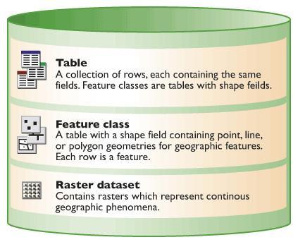
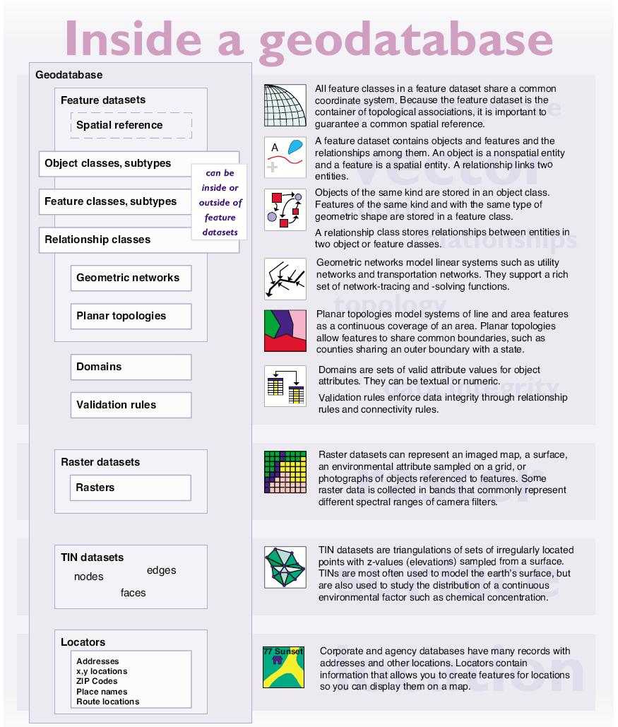
Inside the geodatabase
 Inside the geodatabase A map portrays geographic information through a series of thematic overlays streets, buildings, water, terrain, imagery So does a geographic information system (GIS) Each geographic
Innovation. The Push and Pull at ESRI. September Kevin Daugherty Cadastral/Land Records Industry Solutions Manager
 Innovation The Push and Pull at ESRI September 2004 Kevin Daugherty Cadastral/Land Records Industry Solutions Manager The Push and The Pull The Push is the information technology that drives research and
PC ARC/INFO and Data Automation Kit GIS Tools for Your PC
 ESRI PC ARC/INFO and Data Automation Kit GIS Tools for Your PC PC ARC/INFO High-quality digitizing and data entry Powerful topology building Cartographic design and query Spatial database query and analysis
The Danish enterprise approach to create and publish nautical products.covering the waters along the west coast of Greenland
 The Danish enterprise approach to create and publish nautical products.covering the waters along the west coast of Greenland Charlotte Bjerregaard Overview of data, charts and tasks Old production/new