Oracle Spatial Koordinatni sustavi, projekcije i transformacije. Dalibor Kušić, mag. ing. listopad 2010.
|
|
|
- Basil Boone
- 6 years ago
- Views:
Transcription
1 Oracle Spatial Koordinatni sustavi, projekcije i transformacije Dalibor Kušić, mag. ing. listopad 2010.
2 Pregled Uvod Koordinatni sustavi Transformacije Projekcije Modeliranje 00:25 Oracle Spatial 2
3 Uvod Longley (2005):...atomic element of geographic information: a triple of location, optionally time, and attribute. Atribut Lokacija Geokodiranje nazivi mjesta, poštanske adrese, poštanski brojevi, koordinatni sustavi, linearno referenciranje, itd... 00:25 Oracle Spatial 3


")

4 Koordinatni sustavi Sustav unutar kojega set koordinata jedinstveno određuje položaj točke u prostoru (u odnosu na nekakvu referencu) Kako primijeniti na površinu Zemlje? 00:25 Oracle Spatial 4


5 Koordinatni sustavi Pravi oblik Zemlje? (iz perspektive GIS-a) Sfera Elipsoid Geoid Litosfera (topografija) 00:25 Oracle Spatial 5

 00:25 Oracle")
6 Koordinatni sustavi Elispoidalni koordinatni sustav Horizontalna lokacija: geografska širina (φ) i dužina (λ) 00:25 Oracle Spatial 6
 b.")
 a. U središte mase (WGS84, GRS80) b.")
7 Koordinatni sustavi Problemi: 1. Koji elipsoid koristiti? a. Povijesni nastao mjerenjima na tlu (Bessel 1841) b. Moderni nastao satelitskim mjerenjima (WGS84, GRS80) 2. Gdje ga smjestiti (u odnosu na Zemlju?) a. U središte mase (WGS84, GRS80) b. S pomakom radi bolje lokalne aproksimacije (Bessel 1841) Položajni datum 00:25 Oracle Spatial 7

8 Koordinatni sustavi Problemi: 3. Visina? 00:25 Oracle Spatial 8
9 Koordinatni sustavi Geografski referentni koordinatni sustav Set koordinata Elipsoidalne, kartezijske, sferične, cilindrične... Datum Elipsoid (GRS80, WGS84, itd...) Položaj u odnosu na Zemlju (geocentrični ili lokalni) Početni meridijan Obično Greenwich Mjerna jedinica Stupnjevi, minute, radijani, itd... 00:25 Oracle Spatial 9
10 Koordinatni sustavi Geografski referentni koordinatni sustav MGI Baziran na lokaliziranom Besselovom elipsoidu HTRS96 Baziran na ETRS89 i GRS80 elipsoidu WGS84 00:25 Oracle Spatial 10

11 Koordinatni sustavi Izbor krivog Datuma? 00:25 Oracle Spatial 11
12 Koordinatni sustavi Izbor krivog Datuma? 00:25 Oracle Spatial 12

13 Transformacije Promjena iz jednog referentnog koordinatnog sustava u drugi Metode Računske (Bursa-Wolf, Molodensky, itd...) Bazirane na matricama 00:25 Oracle Spatial 13
14 Transformacije Bursa-Wolf metoda Coordinate frame rotation transformation, Position vector transformation 7 parametara: Rotacija (Rx, Ry, Rz) Pozitivni smjer rotacije varira Translacija (dx, dy, dz) Skaliranje (s) u dx v = dy (1 s) Rz w dz Ry Rz 1 Rx Ry x Rx y 1 z 00:25 Oracle Spatial 14

15 Transformacije Bursa-Wolf metoda 00:25 Oracle Spatial 15
16 Projekcije Kako prikazati trodimenzionalni elipsoid na ravnoj plohi? 00:25 Oracle Spatial 16
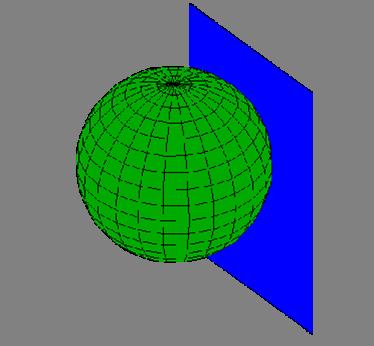

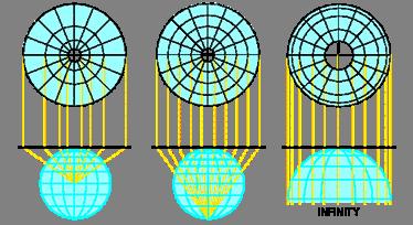
17 Projekcije Translacija 3D prostora u 2D 00:25 Oracle Spatial 17
18 Projekcije Neizostavno degradiraju prostorna svojstva promatranog područja Oblik Površinu Udaljenosti Azimut Projekcije obično održavaju 2 ili 3 svojstva no niti jedna sve! 00:25 Oracle Spatial 18
19 Projekcije Plate Carrée Najjednostavnija Meridijani i paralele se mapiraju u jednako razmaknute vertikalne i horizontalne linije X = λcos φ 1 (φ 1 = 0 u općem slučaju) Y = φ Značajne distorzije sa udaljavanjem od početne paralele 00:25 Oracle Spatial 19

20 Projekcije Plate Carrée 00:25 Oracle Spatial 20


21 Projekcije Neke od standardnih projekcija Planarna Konusna Cilindrična 00:25 Oracle Spatial 21

22 Projekcije Što je sa visinom (ponovno)? Elipsoidna visina vezanog položajnog datuma Drugi modeli Geoid - ekvipotencijalna ploha Zemljinog gravitacijskog polja Geoid Visinski datum referentni model za određivanje visine značajki 00:25 Oracle Spatial 22
23 Projekcije Što je sa visinom (ponovno)? RH H h 44m undulacija geoida 00:25 Oracle Spatial 23
24 Model koordinatnog sustava Položajni datum 00:25 Oracle Spatial 24
25 Model koordinatnog sustava EPSG European Petroleum Survey Group OGP Surveying and Positioning Committee Baza podataka elipsoida, datuma, koordinatnih sustava i ostalih komponenti Referentna lista identifikatora Integrirana u Oracle Spatial 00:25 Oracle Spatial 25

26 Pitanja? IN2 d.o.o. Marohnićeva 1/ Zagreb, HR tel:
Uvod u relacione baze podataka
 Uvod u relacione baze podataka Ana Spasić 2. čas 1 Mala studentska baza dosije (indeks, ime, prezime, datum rodjenja, mesto rodjenja, datum upisa) predmet (id predmeta, sifra, naziv, bodovi) ispitni rok
Cyclical Surfaces Created by a Conical Helix
 Professional paper Accepted 23.11.2007. TATIANA OLEJNÍKOVÁ Cyclical Surfaces Created by a Conical Helix Cyclical Surfaces Created by a Conical Helix ABSTRACT The paper describes cyclical surfaces created
NEKE PRIMJENE MATEMATIKE U GEODEZIJI
 SVEUČILIŠTE U ZAGREBU PRIRODOSLOVNO MATEMATIČKI FAKULTET MATEMATIČKI ODSJEK Zoran Brajković NEKE PRIMJENE MATEMATIKE U GEODEZIJI Diplomski rad Voditelj rada: prof. dr. sc. Nenad Antonić Zagreb, kolovoza
A Method for High Precision Coordinate Transformation in Environmental GIS Applications
 EnviroInfo 2007 (Warschau) Environmental Informatics and Systems Research A Method for High Precision Coordinate Transformation in Environmental GIS Applications Ivica Ruzic, Jadranka Pecar-Ilic 1 Abstract
Why it was necessary? Geodetic Datums. Type of Geodetic Datum. Nothing but spheroid of origin. We need. Local Datum Definitions in Dubai Emirate
 Why it was necessary? Dubai Eirate Between Clark880 and Spheroid.Al Marzooqi, H.Fashir, Syed Iliyas Ahed ( Dubai, United Arab Eirates ) About 9000 control points were available on Clark880 UTM Whole ilitary
TEORIJA SKUPOVA Zadaci
 TEORIJA SKUPOVA Zadai LOGIKA 1 I. godina 1. Zapišite simbolima: ( x nije element skupa S (b) d je član skupa S () F je podskup slupa S (d) Skup S sadrži skup R 2. Neka je S { x;2x 6} = = i neka je b =
NIPP. Implementing rules for metadata. Ivica Skender NSDI Working group for technical standards.
 Implementing rules for metadata Ivica Skender NSDI Working group for technical standards ivica.skender@gisdata.com Content Working group for technical standards INSPIRE Metadata implementing rule Review
NAPREDNI FIZIČKI PRAKTIKUM II studij Geofizika POLARIZACIJA SVJETLOSTI
 NAPREDNI FIZIČKI PRAKTIKUM II studij Geofizika POLARIZACIJA SVJETLOSTI studij Geofizika NFP II 1 ZADACI 1. Izmjerite ovisnost intenziteta linearno polarizirane svjetlosti o kutu jednog analizatora. Na
ANALYSIS OF THE RELIABILITY OF THE "ALTERNATOR- ALTERNATOR BELT" SYSTEM
 I. Mavrin, D. Kovacevic, B. Makovic: Analysis of the Reliability of the "Alternator- Alternator Belt" System IVAN MAVRIN, D.Sc. DRAZEN KOVACEVIC, B.Eng. BRANKO MAKOVIC, B.Eng. Fakultet prometnih znanosti,
Initial Considerations on Modernization of the Croatian Height Reference System
 Initial Considerations on Modernization of the Croatian Height Reference System Matej Varga 1, Olga Bjelotomić 1, Tomislav Bašić 1 1 Faculty of Geodesy, University of Zagreb, Kačićeva 26, Zagreb, Croatia,
QUARRY STABILITY ANALYSIS FOR COMPLEX SLIP SURFACES USING THE MATHSLOPE METHOD
 Rudarsko-geološko-naftni zbornik Vol. 16 str. 91-96 Zagreb, 2004. UDC 622.1:681.14 UDK 622.1:681.14 Original scientific paper Originalni znanstveni rad QUARRY STABILITY ANALYSIS FOR COMPLEX SLIP SURFACES
SOUND FIELD MEASUREMENT IN THE BOUNDED PLAIN
 SOUND FIELD MEASUREMENT IN THE BOUNDED PLAIN Bojan Ivan~evi}, Igor Zori} 1 and Marjan Sikora 2 Faculty of Electrical Engineering and Computing, Unska 3, HR-10000 Zagreb, Croatia, e-mail: bojan.ivancevic@fer.hr
Zlatko Mihalić MOLEKULARNO MODELIRANJE (2+1, 0+0)
") Zlatko Mihalić MOLEKULARNO MODELIRANJE (2+1, 0+0) Asistenti doc. dr. sc. Ivan Kodrin dr. sc. Igor Rončević Literatura A. R. Leach, Molecular Modelling, Principles and Applications, 2. izdanje, Longman,
Zlatko Mihalić MOLEKULARNO MODELIRANJE (2+1, 0+0) Asistenti doc. dr. sc. Ivan Kodrin dr. sc. Igor Rončević Literatura A. R. Leach, Molecular Modelling, Principles and Applications, 2. izdanje, Longman,
Intro to GIS Fall 2010 Georeferencing & Map Projections
 Intro to GIS Fall 2010 Georeferencing & Map Projections SHAPE OF THE EARTH Earth's Shape Geoid: shape of earth minus topographic features (irregular due to local variations in gravity) Ellipsoid: elongated
What is Geodesy? Types of Geodesy terrestrial or classical geodesy space geodesy theoretical geodesy
 What is Geodesy? Geodesy is the study of: The size, shape and motion of the earth The measurement of the position and motion of points on the earth's surface, and The study of the earth's gravity field
Rešenja zadataka za vežbu na relacionoj algebri i relacionom računu
 Rešenja zadataka za vežbu na relacionoj algebri i relacionom računu 1. Izdvojiti ime i prezime studenata koji su rođeni u Beogradu. (DOSIJE WHERE MESTO_RODJENJA='Beograd')[IME, PREZIME] where mesto_rodjenja='beograd'
Geographic Information Systems class # 1 February 19, Coordinate reference systems in GIS: geodetic coordinates
 Geographic Information Systems class # 1 February 19, 2013 Coordinate reference systems in GIS: geodetic coordinates Manuel Campagnolo ISA Manuel Campagnolo (ISA) GIS/SIG 2012 2013 February 19, 2013 1
Lecture 4. Coordinate Systems & Projections
 Lecture 4 Coordinate Systems & Projections Outline Geodesy Geoids Ellipsoids Geographic Coordinate Systems Magnetic North vs. True North Datums Projections Applying Coordinate Systems and Projections Why
SOUND SOURCE INFLUENCE TO THE ROOM ACOUSTICS QUALITY MEASUREMENT
 ISSN 1330-3651 (Print), ISSN 1848-6339 (Online) DOI: 10.17559/TV-20150324110051 SOUND SOURCE INFLUENCE TO THE ROOM ACOUSTICS QUALITY MEASUREMENT Siniša Fajt, Miljenko Krhen, Marin Milković Original scientific
GEOGRAPHIC COORDINATE SYSTEMS
 GEOGRAPHIC COORDINATE SYSTEMS Introduction to GIS Winter 2015 What is Georeferencing? Used to establish a location on the Earth s surface 1 st order polynomial transformation Georeferencing toolbar What
Lesson 5: Map Scale and Projections
 Organizing Data and Information Lesson 5: Map Scale and Projections Map Scales Projections Information can be organized as lists, numbers, tables, text, pictures, maps, or indexes. Clusters of information
Termodinamika. FIZIKA PSS-GRAD 29. studenog Copyright 2015 John Wiley & Sons, Inc. All rights reserved.
 Termodinamika FIZIKA PSS-GRAD 29. studenog 2017. 15.1 Thermodynamic Systems and Their Surroundings Thermodynamics is the branch of physics that is built upon the fundamental laws that heat and work obey.
PROSPECTING FITNESS OF VN-2000 DATUM TO EGM2008
 PROSPECTING FITNESS OF VN-2000 DATUM TO EGM2008 Le Trung Chon 1 1 HCMC University of Technology, VNU-HCM 268 Lý Thuong Kiet, District 10, Ho Chi Minh City, Viet Nam Email: ltchon@hcmut.edu.vn ABSTRACT
Geodetics: Implications for GIS Professionals May 10, 2018
 Experts in Geomatics, Surveying, Positioning, Geospatial Data, and Mapping Sciences Geodetics: Implications for GIS Professionals May 10, 2018 Michael Barnes APSG Education Foundation Chair 2010-2020 APSG
Mapping coordinate systems
 Mapping coordinate systems 1. The Earth's Graticule Latitude and Longitude The graticule is the imaginary grid of lines running east-west (lines of latitude = parallels) and north-south lines of longitude
Impuls sile i količina gibanja
 Impuls sile i količina gibanja FIZIKA PSS-GRAD 25. listopada 2017. 7.1 Teorem impulsa sile i količine gibanja sila vrijeme U mnogim slučajevima sila na tijelo NIJE konstantna. 7.1 Teorem impulsa sile i
Georeferencing. Where on earth are we? Critical for importing and combining layers for mapping
 Georeferencing Where on earth are we? Critical for importing and combining layers for mapping 1. The Geoid Earth is not a perfect sphere, it is ellipsoidal.. earth is the 'Geoid'. The difference between
Using the Energy Balance Method in Estimation of Overhead Transmission Line Aeolian Vibrations
 Strojarstvo 50 (5) 69-76 (008) H. WOLF et. al., Using the Energy Balance Method in Estimation... 69 CODEN STJSAO ISSN 056-887 ZX470/35 UDK 6(05)=86=0=30 Using the Energy Balance Method in Estimation of
Map projections. Rüdiger Gens
 Rüdiger Gens Coordinate systems Geographic coordinates f a: semi-major axis b: semi-minor axis Geographic latitude b Geodetic latitude a f: flattening = (a-b)/a Expresses as a fraction 1/f = about 300
NEW GEODETIC REFERENCE FRAME KOSOVAREV 01
 Bashkim IDRIZI Ismail KABASHI NEW GEODETIC REFERENCE FRAME KOSOVAREV 01 Overview: Basic data of the Republic of Kosova Geodetic referent frame before year 2001 KOSOVAREF 01 KOSOVAREF 01 1 st order Observations
Summary of Presentation:
 Development of Geodetic GPS Infrastructure and Its : The Malaysia Experience BY Abd Majid.A.Kadir, Shahrum Ses, Kamaluddin Omar & Abdullah Hisam Omar Fac. of Geoinformation Science and Eng. Universiti
Hitchhiker s s Guide to Coordinate Systems and Spatial References. Melita Kennedy
 Hitchhiker s s Guide to Coordinate Systems and Spatial References Melita Kennedy Outline Coordinate systems geographic/projected/vertical Geographic/datum transformations Common coordinate systems UTM
Spatial Reference Systems. Introduction
 Spatial Reference Systems Wolfgang Kainz Professor of Cartography and Geoinformation Department of Geography and Regional Research University of Vienna wolfgang.kainz@univie.ac.at Introduction Historic
Mathcad sa algoritmima
 P R I M J E R I P R I M J E R I Mathcad sa algoritmima NAREDBE - elementarne obrade - sekvence Primjer 1 Napraviti algoritam za sabiranje dva broja. NAREDBE - elementarne obrade - sekvence Primjer 1 POČETAK
DIFFERENTIAL EQUATIONS
 DIFFERENTIAL EQUATIONS 1. Basic Terminology A differential equation is an equation that contains an unknown function together with one or more of its derivatives. 1 Examples: 1. y = 2x + cos x 2. dy dt
Projektovanje paralelnih algoritama II
 Projektovanje paralelnih algoritama II Primeri paralelnih algoritama, I deo Paralelni algoritmi za množenje matrica 1 Algoritmi za množenje matrica Ovde su data tri paralelna algoritma: Direktan algoritam
Transformation between the Local and Global Geodetic Datum in Croatia
 Adoptions of ETRS89 229 Transformation between the Local and Global Geodetic Datum in Croatia T. BA Id 1, Ò. BAfId 2 Abstract Thanks to the several GPS campaigns, made in the last six years, it was possible
SVEUČILIŠTE U ZAGREBU GEODETSKI FAKULTET
 SVEUČILIŠTE U ZAGREBU GEODETSKI FAKULTET Ivan Janković i Ivan Racetin GLOBALNI GEOPOTENCIJALNI MODELI I NJIHOVA VIZUALIZACIJA Zagreb, 2012. Ovaj rad izrađen je na Geodetskom fakultetu, Sveučilišta u Zagrebu,
električna polja gaussov zakon električni potencijal
 električna polja gaussov zakon električni potencijal Svojstva električnih naboja - Benjamin Franklin (1706-1790) nizom eksperimenata pokazao je postojanje dvije vrste naboja: pozitivan i negativan - pozitivan
DIFFERENTIAL EQUATIONS
 DIFFERENTIAL EQUATIONS 1. Basic Terminology A differential equation is an equation that contains an unknown function together with one or more of its derivatives. 1 Examples: 1. y = 2x + cos x 2. dy dt
The Gauss Conform Coordinate
 Surveying The South African Coordinate Reference System (Part 2) by Aslam Parker, Chief Directorate: National Geo-spatial Information Part 1 of this article (see PositionIT Nov/Dec 2011) focused on the
ARC241 Structural Analysis I Lecture 5, Sections ST4.5 ST4.10
 Lecture 5, Sections ST4.5 ST4.10 ST4.5) Moment of a Force about a Specified Axis ST4.6) Moment of a Couple ST4.7) Equivalent System ST4.8) Resultant of a Force and a Couple System ST4.9) Further Reduction
NAVIPAC 4 GEODETIC CONTROL
 NAVIPAC 4 GEODETIC CONTROL Contents 1 Introduction... 4 2 Projections... 5 2.1 Projections in general... 6 2.2 Specific projections... 7 2.2.1 Transverse Mercator... 7 2.2.2 Universal Transverse Mercator...
Geoinformatika Geografski informacijski sustavi
 Geoinformatika Geografski informacijski sustavi Geoinformatika, smjer: istraživački studij geografije, 5. i 6. semestar Dr. sc. Aleksandar Toskić, izv. prof. Geografski odsjek PMF-a Sveučilišta u Zagrebu
Height systems. Rudi Gens Alaska Satellite Facility
 Rudi Gens Alaska Satellite Facility Outline Why bother about height systems? Relevant terms Coordinate systems Reference surfaces Geopotential number 2 Why bother about height systems? give a meaning to
A NEW THREE-DIMENSIONAL CHAOTIC SYSTEM WITHOUT EQUILIBRIUM POINTS, ITS DYNAMICAL ANALYSES AND ELECTRONIC CIRCUIT APPLICATION
 A. Akgul, I. Pehlivan Novi trodimenzijski kaotični sustav bez točaka ekvilibrija, njegove dinamičke analize i primjena elektroničkih krugova ISSN 1-61 (Print), ISSN 1848-69 (Online) DOI: 1.179/TV-1411194
FINITE-DIFFERENCE MODELING OF DIELECTRIC INTERFACES IN ELECTROMAGNETICS AND PHOTONICS
 INFOTEH-JAHORINA Vol. 9, Ref. E-V-1, p. 697-701, March 2010. FINITE-DIFFERENCE MODELING OF DIELECTRIC INTERFACES IN ELECTROMAGNETICS AND PHOTONICS MODELOVANJE RAZDVOJNIH DIELEKTRIČNIH POVRŠI U ELEKTROMAGNETICI
5 Coordinate Reference Systems
 5 Coordinate Reference Systems 5.1 Overview The INSPIRE theme Coordinate reference systems (CRS) provides a harmonised specification for uniquely referencing spatial information, either using three-dimensional,
Geocentric Datum of Australia - GDA
 Geocentric Datum of Australia - GDA Supporting GDA94 ARC/INFO 7.2.1 ArcView 3.1 An ESRI Australia White Paper September 1999 White Paper Series OVERVIEW... 1 INTRODUCTION... 1 PART 1 ESRI SOLUTION... 2
INTRODUCTION TO LOW FREQUENCY LOCAL PLASMONS IN BULK EXTRINSIC SEMICONDUCTORS UDC 538.9; Yuri Kornyushin
 FACTA UNIVERSITATIS Series: Physics, Chemistry and Technology Vol. 2, N o 5, 2003, pp. 253-258 INTRODUCTION TO LOW FREQUENCY LOCAL PLASMONS IN BULK EXTRINSIC SEMICONDUCTORS UDC 538.9; 621.315.5 Yuri Kornyushin
REVIEW OF GAMMA FUNCTIONS IN ACCUMULATED FATIGUE DAMAGE ASSESSMENT OF SHIP STRUCTURES
 Joško PAUNOV, Faculty of Mechanical Engineering and Naval Architecture, University of Zagreb, Ivana Lučića 5, H-10000 Zagreb, Croatia, jparunov@fsb.hr Maro ĆOAK, Faculty of Mechanical Engineering and Naval
A simple solution for georeferencing the Cassini map series of France
 Gábor Timár, János Mészáros, Gábor Molnár A simple solution for georeferencing the Cassini map series of France Keywords: Cassini map; France; georeference; GIS; historic maps Summary: The Cassini map
Uvod u GIS PROMETNI GEOINFORMACIJSKI SUSTAVI. Uvod UVOD U GIS. Prometni geoinformacijski sustavi Uvod u GIS 1
 Sveučilište u Zagrebu Fakultet prometnih znanosti Uvod u GIS PROMETNI GEOINFORMACIJSKI SUSTAVI 2010/2011 Uvod GIS Primjene GIS a Geoprostorni podaci GIS operacije GIS modeli i modeliranje 1 3 Uvod... PROMETNI
NAPREDNI FIZIČKI PRAKTIKUM 1 studij Matematika i fizika; smjer nastavnički MJERENJE MALIH OTPORA
 NAPREDNI FIZIČKI PRAKTIKUM 1 studij Matematika i fizika; smjer nastavnički MJERENJE MALIH OTPORA studij Matematika i fizika; smjer nastavnički NFP 1 1 ZADACI 1. Mjerenjem geometrijskih dimenzija i otpora
REFERENCING COORDINATE SYSTEMS MAP PROJECTIONS GEOREFERENCING
 GIS in Ecology SPATIAL REFERENCING COORDINATE SYSTEMS MAP PROJECTIONS GEOREFERENCING : :1 Where on earth? Early mapmakers recognized the need for a system that could locate features on the earth's surface.
WHERE ARE YOU? Maps & Geospatial Concepts Fall 2012
 WHERE ARE YOU? Maps & Geospatial Concepts Fall 2012 Where are you? Relative location I m at school Absolute Location 45 26 18.07 122 43 50.78 Datums Datums A reference surface of the Earth Used as the
HAA je potpisnica multilateralnog sporazuma s Europskom organizacijom za akreditaciju (EA) HAA is a signatory of the European co-operation for
 HAA is a signatory of the European co-operation for") HAA je potpisnica multilateralnog sporazuma s Europskom organizacijom za akreditaciju (EA) HAA is a signatory of the European co-operation for Accreditation (EA) Multilateral Agreement PRILOG POTVRDI O
HAA je potpisnica multilateralnog sporazuma s Europskom organizacijom za akreditaciju (EA) HAA is a signatory of the European co-operation for Accreditation (EA) Multilateral Agreement PRILOG POTVRDI O
Geospatial Data Standards Considerations for the delivery of 2D and 3D spatial data February 2019
 Geospatial Data Standards Considerations for the delivery of 2D and 3D spatial data February 2019 Prepared by: GRCA Geomatics Version Date Summary of Changes Changes Made By: 1.00 March 16, 2018 Version
WHERE ARE YOU? Maps & Geospatial Concepts Fall 2015
 WHERE ARE YOU? Maps & Geospatial Concepts Fall 2015 Where are you? Relative location I m at school Absolute Location 45 26 18.07 122 43 50.78 Where is Boston? Introducing Geodesy, Ellipsoids & Geoids Geodesy
APPLICATION OF ARTIFICIAL NEURAL NETWORKS TO HEIGHT TRANSFORMATION
 M. Yilmaz i dr. Primjena umjetnih neuronskih mreža na transformaciju visine ISSN 1330-3651(Print), ISSN 1848-6339 (Online) DOI: 10.17559/TV-0151116094353 APPLICATION OF ARTIFICIAL NEURAL NETWORKS TO HEIGHT
MAR-E1004 Basics of GIS: Georeferencing Jaakko Madetoja Slides adopted from Paula Ahonen-Rainio
 MAR-E1004 Basics of GIS: Georeferencing Jaakko Madetoja Slides adopted from Paula Ahonen-Rainio Learning goals In this session you will learn To describe the basics of different types of referencing systems
Raquel Prado. Name: Department of Applied Mathematics and Statistics AMS-131. Spring 2010
 Raquel Prado Name: Department of Applied Mathematics and Statistics AMS-131. Spring 2010 Final Exam (Type B) The midterm is closed-book, you are only allowed to use one page of notes and a calculator.
Fri. Jan. 26, Demonstration of QGIS with GPS tracks. Types of data, simple vector (shapefile) formats
 formats") Fri. Jan. 26, 2018 Demonstration of QGIS with GPS tracks Types of data, simple vector (shapefile) formats Map projections, Coordinate Reference Systems Demonstration of QGIS with geologic map 1 Raster
Fri. Jan. 26, 2018 Demonstration of QGIS with GPS tracks Types of data, simple vector (shapefile) formats Map projections, Coordinate Reference Systems Demonstration of QGIS with geologic map 1 Raster
Math 4317 : Real Analysis I Mid-Term Exam 1 25 September 2012
 Instructions: Answer all of the problems. Math 4317 : Real Analysis I Mid-Term Exam 1 25 September 2012 Definitions (2 points each) 1. State the definition of a metric space. A metric space (X, d) is set
THE PROBLEM OF DIOPHANTUS FOR INTEGERS OF Q( 3) Zrinka Franušić and Ivan Soldo
 Zrinka Franušić and Ivan Soldo") RAD HAZU. MATEMATIČKE ZNANOSTI Vol. 8 = 59 (04): 5-5 THE PROBLEM OF DIOPHANTUS FOR INTEGERS OF Q( ) Zrinka Franušić and Ivan Soldo Abstract. We solve the problem of Diophantus for integers of the quadratic
RAD HAZU. MATEMATIČKE ZNANOSTI Vol. 8 = 59 (04): 5-5 THE PROBLEM OF DIOPHANTUS FOR INTEGERS OF Q( ) Zrinka Franušić and Ivan Soldo Abstract. We solve the problem of Diophantus for integers of the quadratic
NGS is Scheduled to Replace NAVD 88 and NAD 83 In 2022
 NGS is Scheduled to Replace NAVD 88 and NAD 83 In 2022 Indiana Society of Professional Land Surveyors Conference January 2017 John Ellingson NGS Geodetic Advisor john.ellingson@noaa.gov 202-306-6904 1
On the Topolog'ical Resonance Energ y of Heteroconjugated Molecules
 CROATICA CHEMICA ACTA CCACAA 54 (1) 75-8 (1981) CCA-1259 YU ISSN 11-1643 UDC 539.19 Original Scientific Paper On the Topolog'ical Resonance Energ y of Heteroconjugated Molecules I. Gutman* Institut fii,r
Working with Projections and Datum Transformations in ArcGIS
 Werner Flacke / Birgit Kraus Working with Projections and Datum Transformations in ArcGIS Theory and Practical Examples First impression 2005 Points Verlag Norden*Halmstad VII Table of Contents Introduction
THE RELATIONSHIP BETWEEN THE ANOMALOUS TRANSMISSION AND THE NEGATIVE EXTINCTION IN THE BRAGG CASE
 ISSN 1330 0008 CODEN FIZAE4 THE RELATIONSHIP BETWEEN THE ANOMALOUS TRANSMISSION AND THE NEGATIVE EXTINCTION IN THE BRAGG CASE XU ZHANGCHENG a b, GUO CHANGLIN b and ZHAO ZONGYAN c a CCAST (World Laboratory),
CHEMICAL REACTION EFFECTS ON VERTICAL OSCILLATING PLATE WITH VARIABLE TEMPERATURE
 Available on line at Association of the Chemical Engineers AChE www.ache.org.rs/ciceq Chemical Industry & Chemical Engineering Quarterly 16 ( 167 173 (010 CI&CEQ R. MUTHUCUMARASWAMY Department of Applied
See discussions, stats, and author profiles for this publication at: READS
 See discussions, stats, and author profiles for this publication at: https://www.researchgate.net/publication/259480162 Map grids and datums Book December 2013 DOI: 10.13140/2.1.2362.0167 CITATIONS 4 READS
GIST 3300 / Geographic Information Systems. Last Time. Today
 GIST 3300 / 5300 Last Time Ellipsoids and Datums Today Map Projections Map Projections Today we will build on the concepts of Geographic Coordinate Systems, Ellipsoids and Datums and add the concepts of
Geodetic Department KTIMATOLOGIO S.A. (Hellenic Cadastre) K. Katsampalos, C. Kotsakis Department of Geodesy and Surveying
 K. Katsampalos, C. Kotsakis Department of Geodesy and Surveying") Realization of ETRS89 in Greece by the HEPOS network M. Gianniou i Geodetic Department KTIMATOLOGIO S.A. (Hellenic Cadastre) mgianniu@ktimatologio.gr K. Katsampalos, C. Kotsakis Department of Geodesy and
Realization of ETRS89 in Greece by the HEPOS network M. Gianniou i Geodetic Department KTIMATOLOGIO S.A. (Hellenic Cadastre) mgianniu@ktimatologio.gr K. Katsampalos, C. Kotsakis Department of Geodesy and
APPROPRIATENESS OF GENETIC ALGORITHM USE FOR DISASSEMBLY SEQUENCE OPTIMIZATION
 JPE (2015) Vol.18 (2) Šebo, J. Original Scientific Paper APPROPRIATENESS OF GENETIC ALGORITHM USE FOR DISASSEMBLY SEQUENCE OPTIMIZATION Received: 17 July 2015 / Accepted: 25 Septembre 2015 Abstract: One
Reference Systems. Paolo Zatelli - Alfonso Vitti. Dept. Civil and Environmental Engineering University of Trento
 Reference Systems Reference Systems Paolo Zatelli - Alfonso Vitti Dept. Civil and Environmental Engineering University of Trento P. Zatelli - A. Vitti University of Trento - Italy 1 / 34 Reference Systems
1. Geospatial technology rarely links geospatial data to nonspatial data. a. True *b. False
 Chapter 2 Where in the Geospatial World Are You? 1. Geospatial technology rarely links geospatial data to nonspatial data. 2. For geospatial technology to work, every location on Earth must be: a. inhabited
Kontrolni uređaji s vremenskom odgodom za rasvjetu i klimu
 KOTROI SKOPOVI ZA RASVJETU I KIMA UREĐAJE Kontrolni i s vremenskom odgodom za rasvjetu i klimu Modularni dizajn, slobodna izmjena konfiguracije Sigurno. iski napon V Efikasno čuvanje energije Sigurnost.
A choice of norm in discrete approximation
 147 A choice of norm in discrete approximation Tomislav Marošević Abstract. We consider the problem of choice of norms in discrete approximation. First, we describe properties of the standard l 1, l 2
EnvSci360 Computer and Analytical Cartography
 EnvSci360 Computer and Analytical Cartography Lecture 3 Geodesy Map Projections, Datums, and Coordinate Systems 1 Geodesy The science of measuring and representing the shape and size of the earth, and
Nedžad Pašalić * UDK Pregledni rad ODREĐIVANJE PARAMETARA ZA TRANSFORMACIJU KOORDINATA SA BESSELOVOG ELIPSOIDA NA ELIPSOID WGS-84
 Pašalić N.: Određivanje parametara za transormaciju koordinata.. 3 Nedžad Pašalić * UDK 58. 36 Pregledni rad ODREĐIANJE PARAMETARA A TRANSFORMACIJU KOORDINATA SA BESSELOOG ELIPSOIDA NA ELIPSOID WGS-84
STRUCTURAL DESIGN OF A TYPHOON CLASS SUBMARINE PROJEKTIRANJE KONSTRUKCIJE PODMORNICE KLASE TYPHOON
 Tomislav ŠABALJA, University of Zagreb, Faculty of Mechanical Engineering and Naval Architecture, Ivana Lučića 5, HR-10000 Zagreb, Croatia, tsabalja@gmail.com Ivo SENJANOVIĆ, University of Zagreb, Faculty
Mobile Mapping Tips and Tricks
 Mobile Mapping Tips and Tricks Projections, Datums and Geoids, May 2017 Introduction This guide is designed to provide a basic understanding of coordinate system projections, datums and geoids. The guide
Modernization of the National Spatial Reference System 2022 Datum. Jacksonville Chapter July 2018
 Modernization of the National Spatial Reference System 2022 Datum Jacksonville Chapter July 2018 Randy Tompkins, PSM, PLS Geomatics Project Manager Surveyor, Hydrographer, & Geodesist DRMP, Inc. Jacksonville,
Geodesy on the move. Craig Allinson. Dealing with dynamic coordinate reference systems. IOGP Geodesy Subcommittee. EPUG London, November 2017
 Geodesy on the move Dealing with dynamic coordinate reference systems Craig Allinson IOGP Geodesy Subcommittee EPUG London, November 2017 Why the concern? A bridge too far Historic geodesy mental image
Homogeneous Transformations
 Purpose: Homogeneous Transformations The purpose of this chapter is to introduce you to the Homogeneous Transformation. This simple 4 x 4 transformation is used in the geometry engines of CAD systems and
UNIT 2 MATHEMATICAL METHODS 2013 MASTER CLASS PROGRAM WEEK 11 EXAMINATION 2 SOLUTIONS SECTION 1 MULTIPLE CHOICE QUESTIONS
 UNIT MATHEMATICAL METHODS 01 MASTER CLASS PROGRAM WEEK 11 EXAMINATION SOLUTIONS FOR ERRORS AND UPDATES, PLEASE VISIT WWW.TSFX.COM.AU/MC-UPDATES SECTION 1 MULTIPLE CHOICE QUESTIONS QUESTION 1 QUESTION QUESTION
Exercise 6: Coordinate Systems
 Exercise 6: Coordinate Systems This exercise will teach you the fundamentals of Coordinate Systems within QGIS. In this exercise you will learn: How to determine the coordinate system of a layer How the
NATRF 2022 AND LDP OCTOBER 11, 2017
 NATRF 2022 AND LDP OCTOBER 11, 2017 MODERNIZATION OF THE NSRS Why? Leaving passive control marks behind and relying solely on the CORS network for 3D positions: Older methodology relies on terrestrial
Introduction to the Planimetry of the Quasi-Hyperbolic Plane
 Original sientifi paper Aepted 20. 12. 2013. ANA SLIEPČEVIĆ IVANA BOŽIĆ HELENA HALAS Introdution to the Planimetry of the Quasi-Hyperboli Plane Introdution to the Planimetry of the Quasi- Hyperboli Plane
Geometrijski smisao rješenja sustava od tri linearne jednadžbe s tri nepoznanice
 Osječki matematički list 6(2006), 79 84 79 Geometrijski smisao rješenja sustava od tri linearne jednadžbe s tri nepoznanice Zlatko Udovičić Sažetak. Geometrijski smisao rješenja sustava od dvije linearne
Parameter estimation of diffusion models
 129 Parameter estimation of diffusion models Miljenko Huzak Abstract. Parameter estimation problems of diffusion models are discussed. The problems of maximum likelihood estimation and model selections
Goal: Use understanding of physically-relevant scales to reduce the complexity of the governing equations
 Scale analysis relevant to the tropics [large-scale synoptic systems]* Goal: Use understanding of physically-relevant scales to reduce the complexity of the governing equations *Reminder: Midlatitude scale
The Volume of a Hypersphere
 The hypersphere has the equation The Volume of a Hypersphere x 2 y 2 x 2 w 2 = 2 if centered at the origin (,,,) and has a radius of in four dimensional space. We approach the project of determining its
Functions of Several Variables: Chain Rules
 Functions of Several Variables: Chain Rules Calculus III Josh Engwer TTU 29 September 2014 Josh Engwer (TTU) Functions of Several Variables: Chain Rules 29 September 2014 1 / 30 PART I PART I: MULTIVARIABLE
On the problem of geoid height transformation between different geodetic reference frames
 On the problem of geoid height transformation between different geodetic reference frames Christopher Kotsakis Department of Geodesy and Surveying Aristotle University of Thessaloniki University Box 440,
Linearni operatori u ravnini
 Linearni operatori u prostoru 1 Linearni operatori u ravnini Rudolf Scitovski Ivana Kuzmanović, Zoran Tomljanović 1 Uvod Neka je (O; e 1, e, e 3 ) pravokutni koordinatne sustav u prostoru X 0 (E). Analogno
APPLICATIONS OF FD APPROXIMATIONS FOR SOLVING ORDINARY DIFFERENTIAL EQUATIONS
 LECTURE 10 APPLICATIONS OF FD APPROXIMATIONS FOR SOLVING ORDINARY DIFFERENTIAL EQUATIONS Ordinary Differential Equations Initial Value Problems For Initial Value problems (IVP s), conditions are specified
Development of the system for automatic map generalization based on constraints
 Development of the system for automatic map generalization based on constraints 3rd Croatian NSDI and INSPIRE Day and 7th Conference Cartography and Geoinformation Marijan Grgić, mag. ing. Prof. dr. sc.
Coordinate Systems. Location on earth is defined by coordinates
 Coordinate Systems We think of the earth as a sphere It is actually a spheroid (ellipsoid), slightly larger in radius at the equator than at the poles Shape of the Earth Location on earth is defined by