Location Based Decision Support GIS for Managers and Administrators
|
|
|
- Shonda Sparks
- 5 years ago
- Views:
Transcription


1 Location Based Decision Support GIS for Managers and Administrators Jim Mitchell, PhD IT GIS Manager Louisiana Dept. of Transportation & Development Kurt Johnson IT GIS Technical Specialist-DCL Louisiana Dept. of Transportation & Development Doug Albert IT Geographic Technical Specialist-DCL Louisiana Department of Transportation & Development Jennifer Harrison President Inner Corridor Technologies, Inc./TeachMeGIS


2 GIS Tool for integrating data from disparate sources. A set of tools for spatial analysis. It s not just a map! A set of tools for document and data management. Digital light table, planimeter, ruler, calculator. A tool for sharing data inside and outside of DOTD, across departments and to the public. Solutions to your daily business problems. GIS is a Solutions Tool!
3 Presentation Overview Presentation topics: What is GIS? What is an Enterprise GIS? Other GIS Resources DOTD GIS Resources
4 What is GIS?

5 What is GIS? It is not just a map! It is a system of software, data, maps, network locations, internet services, models, work flows and procedures. database database

6 What is GIS? At the core is the ArcGIS Software, which is a toolset (like Microsoft Office). The software displays maps, which are tied to database tables. But that is just the beginning.
7 ESRI Software Installed at DOTD No. Section Name No. Section Name 02 New Orleans District 45 Traffic Engineering and Services 03 Lafayette District 47 Legal 04 Bossier City/Shreveport District 51 Bridge Maintenance & Facilities 05 Monroe District 53 Chief Engineer Construction & Maintenance 07 Lake Charles District 55 Assistant Secretary of Operations 08 Alexandria District 56 ITS 13 Information Technology 58 Chase District 19 Research (LTRC) 59 C.C.C. 21 Data Collection & Analysis 61 Baton Rouge District 22 Materials and Testing 62 Hammond District 24 Road Design 64 Public Works 25 Bridge and Structural Design 66 Intermodal Transportation 28 Environmental 67 Pavement and Geotechnical Services 29 Utility Relocation 68 Systems Engineering 30 Location & Survey 77 Traffic Engineering Management 34 Project Management 80 Contract Services 40 Constructing 82 Traffic Safety 41 System Preservation 85 Transportation Planning 42 Maintenance Systems 88 Aviation
8 GIS and CADD GIS maps are not just graphics. They are data. CADD GIS A rich collection of graphics Geospatial Reference Layers do not interact no topology No geospatial reference Data Display and Analysis Ad hoc applications Ability to create new information combining data from disparate sources.

 GIS Optimized for Display Dynamic data over a static base map")
9 GIS and Visualization GIS compared to visualization - consumer mapping products such as - Bing, Google, Yahoo, Map Quest and others. Consumer Mapping Optimized for display Static data canned base map No geoprocessing (analytical capabilities) Limited access to geospatial functions (geocoding and routing only) GIS Optimized for Display Dynamic data over a static base map Dynamic symbology Rich geoprocessing and analytical functions Ability to create new information from disparate data sources

10 GIS and Visualization
11 GIS: Software- Data Tools - Sharing The software accesses map layers and database tables. The software gives the user tools to ask questions of the maps Which schools are within ¼ mile of an interstate? How many miles of state roads are in Orleans Parish? Which state roads are used for sugar cane trucks during sugar cane season? Query results are combined into new information. Any map and any query results can be published to the web for the public or to an intranet site for DOTD. If you can make a map of it, it can be put on a website!

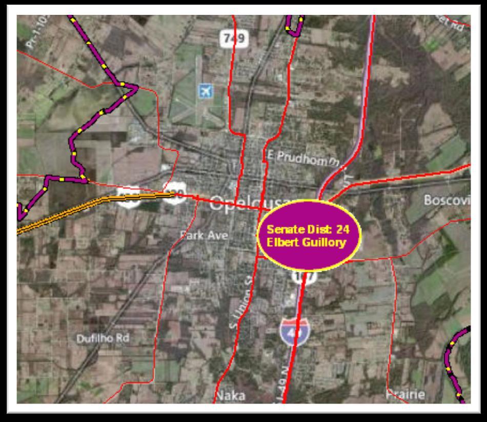
12 What is GIS? It is a tool for accessing information across the entire DOTD enterprise and information from other state agencies. What current projects are in Senate District 25?
13 What is GIS? It is a system that combines data from disparate sources to create new information. Are there any oil fields near this construction project (will truck traffic be a consideration?)

14
15


16 What is GIS? It is a set of tools for measuring and analyzing data. Throw away the light table, the planimeter, ruler, and calculator. It s all in GIS! Debris Removal
17 What is GIS? It is a tool for performing spatial analysis. Extracting information and deriving solutions by analyzing the locations and the data related to those locations. In which parishes are there roads with high average daily traffic? How many miles of road have high ADT?
18 What are the Parishes with the Highest ADT? Step1 - Select by Attribute, from the STL, the highway segments with ADT > 100,000 Step 2 - Select by Location, the Parishes, using the previously selected highway segments where ADT > 100,000 Parishes with ADT > 100,000 BOS CAD DOTD District 04 DES SBN RDR DOTD District 08 BRG CLC DOTD District 07 NCH VRN CMR CLB BNV ALN JFD LNC JCK WIN GRT UNI RPD EVN ACD OCH CTH LSL VRM CLD AVY MRH SLN RCH FRL TNS SMT IBR DOTD District 05 PTC SMY MDS DOTD District 58 WFL IBV DOTD District 03 DOTD District 62 EFL EBR SHL LVN TRB TNG LFU WSH STM ORL DOTD District 02 PLQ SBR Bossier Caddo East Baton Rouge Jefferson Orleans West Baton Rouge
19 What are the Parishes with the Highest ADT? Perform a Spatial Join to summarize the ADT statistics on highway segments falling in each Parish The result is a Parish dataset with attributes containing rthe summary statistics from the highway segments in that Parish CLB UNI MRH BOS LNC CAD OCH RCH BNV MDS JCK DES RDR CLD FRL TNS WIN NCH LSL CTH GRT SBN RPD VRN AVY WFL EFL SHL WSH EVN BRG ALN SLN PTC EBR TNG LVN STM CLC JFD ACD SMT IBV ORL CMR VRM SMY LFU IBR TRB PLQ SBR Legend Average ADT by Parish Average ADT / Road Mileage
20 What is an Enterprise GIS? One software, one database, one set of maps, all shared across DOTD. An Enterprise GIS allows for and encourages: Interoperability Consistency Universal access to data across the entire organization Data and mapping standards


21 IT GIS Staff maintain a GIS Database and a set of GIS maps and procedures. Data is shared with mobile apps GIS staff publish maps via ArcGIS Server and share data via SDE to DOTD staff and to the public, via ArcGIS datasets or and ArcGIS Online Enterprise GIS DOTD staff, staff from other local, state and federal agencies and the public access the maps and/or data layers and tools via web browsers, data viewers and/or the ArcGIS Software suite. GIS data is stored on LADOTD servers. Data from other state and federal agencies may also be incorporated in the shared maps Data Exchange
22 Why Enterprise GIS is Important Enterprise GIS creates a common operational picture across the organization that facilitates: Universal access to the technology Multiple levels of technology support different levels of use All levels of technology interact seamlessly Universal access to the organization s data Universal access to support by users Enterprise GIS supports one version of the truth and promotes the flow and integration of data across the organization


23 Who uses the Enterprise GIS? An Enterprise GIS accommodates different levels of users. LEVEL 0 LEVEL 1 LEVEL 2 Casual user accesses GIS with visualization tools. Occasional user of map data. Accesses GIS via canned maps and desktop applications. Regular user of GIS, works with data on a GIS map to develop ad hoc analysis, create new information from existing data and access data from the enterprise database and web services. LEVEL 3 Advanced User, regularly performs sophisticated spatial analysis and modeling, and creates new data.

24 Level 0 Users The public, DOTD, other local, state and federal agencies can access any number of web applications served via ArcGIS server without knowing anything about GIS. LEVEL 0 Casual user accesses GIS with visualization tools. Web maps are pre-defined. Users can pan, zoom and turn layers on and off but have limited access to add their own layers from the DOTD GIS database and web services.


25 Level 1 Users Occasional users of GIS data can access canned maps via ArcGIS Explorer, ArcGIS Online and web maps. LEVEL 1 Occasional user of map data. Accesses GIS via canned maps and desktop applications. Users start either with a generic basemap or a LADOTD base map, and can easily add additional data layers from the DOTD GIS database. Simple analysis is performed.
 and")
26 Level 2 Users Some users benefit from accessing GIS from the ArcGIS software. Those users are people who: Need data from a GIS map on a regular basis Want to do ad hoc analysis Need to create their own data These users usearcgis Desktop (usually the Basic license level) and access GIS data from SDE and/or ArcGIS servers. LEVEL 2 Regular user of GIS, works with data on a GIS map to develop ad hoc analysis, create new information from existing data and access data from the enterprise database and web services.

27 Level 3 Users Individuals who accomplish a major portion of their work using ArcGIS Advanced. These users Create new data Edit the enterprise data Perform complex analysis Produce sophisticated cartographic products Advanced User, regularly performs sophisticated spatial analysis LEVEL 3 and modeling, and creates new data.
28 Who is using GIS? Many local, state and federal agencies share GIS data, including: DNR - SONRIS DEQ Make a Map State Lands State water-bottoms. USGS - National Hydrography Dataset (NHD) USGS - National Elevation Dataset (NED) NRCS (National Resources Conservation Service) - SSURGO FEMA Flood Maps site, MapMd site Bureau of Ocean Energy Management (BOEMR and BSE)
29 Who is Using GIS? Private industry: Engineering, surveying and construction Oil companies Marketing companies Local water, electric and gas distribution companies Cell phone companies Local Government: School districts (bus routing, attendance zones) Long-range planning Assessor s offices Police, fire, and emergency response Levee Districts Hospitals Everybody!

30 DOTD GIS How is DOTD using GIS today? Topographic Mapping Program Louisiana Road Base Map DOTD s USGS HydroWatch Stream Gauge Site DOTD Construction Site Maintaining the GEODATABASE of Louisiana (GOL)


31 Example MS4

32
33 GPS Technology Management Plan EDSM Objectives Establish a GPS Technology Oversight Committee (GTOC) Standardize policies and procedures for the accurate, efficient, and safe operation of GPS Document data accuracy to improve interoperability with GIS and other target databases Improve GPS hardware/software use. Streamline operation, data collection, and maintenance Standardized training for DOTD staff and consultants Improve cost effectiveness of DOTD s GPS Investment

34 Topographic Mapping Program


35 LA DOTD ArcGIS Server Demonstration


36 TerraGo PDFs Demonstration

37 ArcGIS Explorer Demonstration


38 ArcGIS.com Demonstration

39 Where can you get help? Submit an IT service request in DOTDport. Contact your IT GIS Staff! These are GIS professionals in the Information Technology Section that manage and maintain GIS data, systems, and applications, and provide technical support and training. Contact:

40 GIS Training ESRI has on-line training courses, and LADOTD holds in-house courses. Find out about both options at:
41 Thanks for coming! Jim Mitchell, PhD IT GIS Manager Louisiana Dept. of Transportation & Development Kurt Johnson IT GIS Technical Specialist-DCL Louisiana Dept. of Transportation & Development Doug Albert IT Geographic Technical Specialist-DCL Louisiana Department of Transportation & Development Jennifer Harrison President Inner Corridor Technologies, Inc./TeachMeGIS
IMPLEMENTING GOVERNMENT-WIDE ENTERPRISE GIS; THE FEDERATED MODEL
 IMPLEMENTING GOVERNMENT-WIDE ENTERPRISE GIS; THE FEDERATED MODEL James E. Mitchell, Ph. D. IT GIS Manager Louisiana Department of Transportation and Development presented at the ESRI International Users
Statewide Topographic Mapping Program
 Statewide Topographic Mapping Program February 28, 2018 www.dotd.la.gov Outline Purpose of the Statewide Topographic Mapping Program History Breakdown of R.S. 48:36 - Topographic Mapping Statewide Topographic
CHAPTER 22 GEOGRAPHIC INFORMATION SYSTEMS
 CHAPTER 22 GEOGRAPHIC INFORMATION SYSTEMS PURPOSE: This chapter establishes the administration and use of to improve the quality and accessibility of Department s spatial information and support graphical
Getting Started with Community Maps
 Esri International User Conference San Diego, California Technical Workshops July 24, 2012 Getting Started with Community Maps Shane Matthews and Tamara Yoder Topics for this Session ArcGIS is a complete
Hurricanes Katrina and Rita created the largest natural disaster in American history
 Overview of the Road Home Program Hurricanes Katrina and Rita created the largest natural disaster in American history In Louisiana: 123,000 homes suffered major damage 82,000 rental properties suffered
ArcGIS Online Tools and Water-Related Web Services You Can Use Every Day of Your Life!
 ArcGIS Online Tools and Water-Related Web Services You Can Use Every Day of Your Life! Brian Rowley, PE, CFM FMA 2014 Annual Conference 1 Gold Rush (49ers) John Sutter Sutter s Mill South fork of American
ArcGIS. for Server. Understanding our World
 ArcGIS for Server Understanding our World ArcGIS for Server Create, Distribute, and Manage GIS Services You can use ArcGIS for Server to create services from your mapping and geographic information system
The Emerging Role of Enterprise GIS in State Forest Agencies
 The Emerging Role of Enterprise GIS in State Forest Agencies Geographic Information System (GIS) A geographic information system (GIS) is a computer software system designed to capture, store, manipulate,
Rural Louisiana. A quarterly publication of the Louisiana Tech Rural Development Center
 Rural Louisiana A quarterly publication of the Louisiana Tech Rural Development Center Volume 4, No. 1, Fall 2009 Editor: Aaron K. Lusby Director, Asst. Professor Newsletter design: Stephanie Tidwell Student
A Summary of State DOT GIS Activities. Presented at the 2000 AASHTO GIS-T Symposium Minneapolis, MN
 A Summary of State DOT GIS Activities Presented at the 2000 AASHTO GIS-T Symposium Minneapolis, MN Information Sources E-mail survey of state DOT GIS managers 49 State DOTs responded in 2000 Results compared
ArcGIS for Desktop. ArcGIS for Desktop is the primary authoring tool for the ArcGIS platform.
 ArcGIS for Desktop ArcGIS for Desktop ArcGIS for Desktop is the primary authoring tool for the ArcGIS platform. Beyond showing your data as points on a map, ArcGIS for Desktop gives you the power to manage
GIS-T 2010 Building a Successful Geospatial Data Sharing Framework: A Ohio DOT Success Story
 GIS-T 2010 Building a Successful Geospatial Data Sharing Framework: A Ohio DOT Success Story ODOT District 2 GIS John Puente District 1 GIS Coordinator\ Planning Administrator 2 Interoperability 3 District
DP Project Development Pvt. Ltd.
 Dear Sir/Madam, Greetings!!! Thanks for contacting DP Project Development for your training requirement. DP Project Development is leading professional training provider in GIS technologies and GIS application
John Laznik 273 Delaplane Ave Newark, DE (302)
") Office Address: John Laznik 273 Delaplane Ave Newark, DE 19711 (302) 831-0479 Center for Applied Demography and Survey Research College of Human Services, Education and Public Policy University of Delaware
Office Address: John Laznik 273 Delaplane Ave Newark, DE 19711 (302) 831-0479 Center for Applied Demography and Survey Research College of Human Services, Education and Public Policy University of Delaware
UNIT 4: USING ArcGIS. Instructor: Emmanuel K. Appiah-Adjei (PhD) Department of Geological Engineering KNUST, Kumasi
 Department of Geological Engineering KNUST, Kumasi") UNIT 4: USING ArcGIS Instructor: Emmanuel K. Appiah-Adjei (PhD) Department of Geological Engineering KNUST, Kumasi Getting to Know ArcGIS ArcGIS is an integrated collection of GIS software products ArcGIS
UNIT 4: USING ArcGIS Instructor: Emmanuel K. Appiah-Adjei (PhD) Department of Geological Engineering KNUST, Kumasi Getting to Know ArcGIS ArcGIS is an integrated collection of GIS software products ArcGIS
Enhancing Louisiana s GNIS
 Enhancing Louisiana s GNIS An Outreach Effort Between USGS and the Louisiana Geographic Information Center Louisiana Remote Sensing and GIS Workshop Lafayette, LA April 28, 2010 Louisiana Geographic Information
Oakland County Parks and Recreation GIS Implementation Plan
 Oakland County Parks and Recreation GIS Implementation Plan TABLE OF CONTENTS 1.0 Introduction... 3 1.1 What is GIS? 1.2 Purpose 1.3 Background 2.0 Software... 4 2.1 ArcGIS Desktop 2.2 ArcGIS Explorer
Introduction to ArcGIS Server - Creating and Using GIS Services. Mark Ho Instructor Washington, DC
 Introduction to ArcGIS Server - Creating and Using GIS Services Mark Ho Instructor Washington, DC Technical Workshop Road Map Product overview Building server applications GIS services Developer Help resources
JOB DESCRI PTI ON. GIS Administrator
 JOB DESCRI PTI ON JOB GRADE: GS-0 Cla ss Code : Office - 8 8 0 DEPARTMENT: 2 0 - FLSA: EXEMPT JOB NO: 6-0 9-2 7 SALARY: To Be De t e rm in e d Job description statements are intended to describe the general
GIS. in the City of Lewiston Maine
 GIS in the City of Lewiston Maine The purpose of this slideshow is to provide an overview of the city GIS and how it is used, maintained and accessed in-house as well as by the public. Please simply hit
Bentley Map Advancing GIS for the World s Infrastructure
 Bentley Map Advancing GIS for the World s Infrastructure Presentation Overview Why would you need Bentley Map? What is Bentley Map? Where is Bentley Map Used? Why would you need Bentley Map? Because your
Techniques for Science Teachers: Using GIS in Science Classrooms.
 Techniques for Science Teachers: Using GIS in Science Classrooms. After ESRI, 2008 GIS A Geographic Information System A collection of computer hardware, software, and geographic data used together for
SoilView: Development of a Custom GIS Application for Publishing Soil Surveys
 SoilView: Development of a Custom GIS Application for Publishing Soil Surveys Allan Johnson and Mike Wigginton Abstract Currently, digital soils information can be obtained from many sources. Numerous
Continental Divide National Scenic Trail GIS Program
 CDNST Vision Statement: Provide the most accurate geospatial locational information of the Continental Divide Trail and nearby resources to the public as well as help provide internal management information
Arcgis Enterprise Performance And Scalability Best Practices
 Arcgis Enterprise Performance And Scalability Best Practices We have made it easy for you to find a PDF Ebooks without any digging. And by having access to our ebooks online or by storing it on your computer,
June 19 Huntsville, Alabama 1
 June 19 Huntsville, Alabama 1 Real-Time Geospatial Data: The Fusion of PI and ArcGIS Enabling Smarter Facilities Management OSIsoft and Esri Mapping and Location Analytics Platform Supporting Your Use
You are Building Your Organization s Geographic Knowledge
 You are Building Your Organization s Geographic Knowledge And Increasingly Making it Available Sharing Data Publishing Maps and Geo-Apps Developing Collaborative Approaches Citizens Knowledge Workers Analysts
Maryland Transit Administration (MTA) Bus Accident Mapping and Analysis Application
 Bus Accident Mapping and Analysis Application") Maryland Transit Administration (MTA) Bus Accident Mapping and Analysis Application Ralign Wells, MTA Administrator Bernadette Bridges, MTA Chief Safety Officer Office of Safety, Quality Assurance, and
Maryland Transit Administration (MTA) Bus Accident Mapping and Analysis Application Ralign Wells, MTA Administrator Bernadette Bridges, MTA Chief Safety Officer Office of Safety, Quality Assurance, and
The GIS Path Forward Saskatchewan s Geomatics Strategic Plan
 The GIS Path Forward Saskatchewan s Geomatics Strategic Plan John Potter, SK Ministry of Central Services Office of Geomatics Coordination Sept.17/13 Table of Contents 1. 2011-2016, Geomatics Strategic
Louisiana Transportation Engineering Conference. Monday, February 12, 2007
 Louisiana Transportation Engineering Conference Monday, February 12, 2007 Agenda Project Background Goal of EIS Why Use GIS? What is GIS? How used on this Project Other site selection tools I-69 Corridor
Maryland Transit Administration (MTA) Bus Accident Mapping and Analysis Application
 Bus Accident Mapping and Analysis Application") Maryland Transit Administration (MTA) Bus Accident Mapping and Analysis Application Ralign Wells, MTA Administrator Bernadette Bridges, MTA Chief Safety Officer Office of Safety, Quality Assurance, and
Maryland Transit Administration (MTA) Bus Accident Mapping and Analysis Application Ralign Wells, MTA Administrator Bernadette Bridges, MTA Chief Safety Officer Office of Safety, Quality Assurance, and
INDOT Office of Traffic Safety
 Intro to GIS Spatial Analysis INDOT Office of Traffic Safety Intro to GIS Spatial Analysis INDOT Office of Traffic Safety Kevin Knoke Section 130 Program Manager Highway Engineer II Registered Professional
Oregon Department of Transportation. Geographic Information Systems Strategic Plan
 Oregon Department of Transportation Geographic Information Systems Strategic Plan Adopted May, 2000 By the GIS Steering Committee Last printed 10/2/2012 4:20:00 PM Page Geographic Information Systems Strategic
FIRE DEPARMENT SANTA CLARA COUNTY
 DEFINITION FIRE DEPARMENT SANTA CLARA COUNTY GEOGRAPHIC INFORMATION SYSTEM (GIS) ANALYST Under the direction of the Information Technology Officer, the GIS Analyst provides geo-spatial strategic planning,
Web GIS Deployment for Administrators. Vanessa Ramirez Solution Engineer, Natural Resources, Esri
 Web GIS Deployment for Administrators Vanessa Ramirez Solution Engineer, Natural Resources, Esri Agenda Web GIS Concepts Web GIS Deployment Patterns Components of an On-Premises Web GIS Federation of Server
Introduction to ArcGIS Server Development
 Introduction to ArcGIS Server Development Kevin Deege,, Rob Burke, Kelly Hutchins, and Sathya Prasad ESRI Developer Summit 2008 1 Schedule Introduction to ArcGIS Server Rob and Kevin Questions Break 2:15
Embracing ArcGIS Server Technology A City s Balanced Approach
 Embracing ArcGIS Server Technology A City s Balanced Approach Sridhar Katragadda Virginia Johnston Esri UC2013. About the City Virginia Beach Metropolitan Statistical Area (MSA) is the 38th largest in
Local Government. VALOR GIS Specialist South Georgia RDC
 Lw Low Cost GIS Sl Solutions for Local Government By: Joe Bendis VALOR GIS Specialist South Georgia RDC SERUG 2008 GIS success through cooperation $ $ VALOR Today: 5 staff members dedicated to VALOR innovations,
Canadian Board of Examiners for Professional Surveyors Core Syllabus Item C 5: GEOSPATIAL INFORMATION SYSTEMS
 Study Guide: Canadian Board of Examiners for Professional Surveyors Core Syllabus Item C 5: GEOSPATIAL INFORMATION SYSTEMS This guide presents some study questions with specific referral to the essential
Finding Common Ground Through GIS
 Finding Common Ground Through GIS Matthew Stone, MPH Special Unit for Technical Assistance Chronic Disease and Injury Control California Department of Public Health ESRI Health GIS Conference Scottsdale,
Why GIS & Why Internet GIS?
 Why GIS & Why Internet GIS? The Internet bandwagon Internet mapping (e.g., MapQuest) Location-based services Real-time navigation (e.g., traffic) Real-time service dispatch Business Intelligence Spatial
Enterprise Linear Referencing at the NYS Department of Transportation
 Enterprise Linear Referencing at the NYS Department of Transportation One Highway Network to Support Many Business Processes May 9, 2018 May 9, 2018 2 Agenda An overview of Linear Referencing How NYSDOT
Data Aggregation with InfraWorks and ArcGIS for Visualization, Analysis, and Planning
 Data Aggregation with InfraWorks and ArcGIS for Visualization, Analysis, and Planning Stephen Brockwell President, Brockwell IT Consulting, Inc. Join the conversation #AU2017 KEYWORD Class Summary Silos
Bentley Map V8i (SELECTseries 3)
") Bentley Map V8i (SELECTseries 3) A quick overview Why Bentley Map Viewing and editing of geospatial data from file based GIS formats, spatial databases and raster Assembling geospatial/non-geospatial data
Bentley Map V8i (SELECTseries 3) A quick overview Why Bentley Map Viewing and editing of geospatial data from file based GIS formats, spatial databases and raster Assembling geospatial/non-geospatial data
e-pathai GIS (Electronic Project, Administration, Traffic, Highway Assets and Information management system) in Tamil Nadu Highways
 in Tamil Nadu Highways") e-pathai GIS (Electronic Project, Administration, Traffic, Highway Assets and Information management system) in Tamil Nadu Highways Er.G.Kumar¹, Er.R.Sendel Raj², Er.P.Eshwarmoorthy³, Dr.P.Rajakumar 4
e-pathai GIS (Electronic Project, Administration, Traffic, Highway Assets and Information management system) in Tamil Nadu Highways Er.G.Kumar¹, Er.R.Sendel Raj², Er.P.Eshwarmoorthy³, Dr.P.Rajakumar 4
Corporate. Information. Railway Infrastructure Administrator. Year indracompany.com
 geospatial and mobility Corporate Geographic Information System of ADIF Railway Infrastructure Administrator. Year 2009-2010 Corporate Geographic Information System of ADIF ADIF. Spanish Administrator
Innovation. The Push and Pull at ESRI. September Kevin Daugherty Cadastral/Land Records Industry Solutions Manager
 Innovation The Push and Pull at ESRI September 2004 Kevin Daugherty Cadastral/Land Records Industry Solutions Manager The Push and The Pull The Push is the information technology that drives research and
Base Maps: Creating, Using & Participating
 Base Maps: Creating, Using & Participating Michael Fashoway & Erin Geraghty Montana Base Map Service Center 2010 MAGIP Technical Session October 28, 2010 What is a Base Map? Using a Base Map Creating a
Information. Information Technology. Geographic. Services (GIS) 119 W Indiana Ave Deland, FL 32720
 119 W Indiana Ave Deland, FL 32720") Information Technology Geographic Information Services (GIS) 119 W Indiana Ave Deland, FL 32720 A GIS consists of 5 primary components: Hardware Software People Data Methods or Business Processes --- Hardware
Information Technology Geographic Information Services (GIS) 119 W Indiana Ave Deland, FL 32720 A GIS consists of 5 primary components: Hardware Software People Data Methods or Business Processes --- Hardware
Creating Basemaps to Manage Buildings and Facilities
 Esri International User Conference San Diego, California Technical Workshops July 26, 2012 Creating Basemaps to Manage Buildings and Facilities Mark Stewart and Tamara Yoder Topics for this Session Overview
Introduction to GIS. Phil Guertin School of Natural Resources and the Environment GeoSpatial Technologies
 Introduction to GIS Phil Guertin School of Natural Resources and the Environment dguertin@cals.arizona.edu Mapping GeoSpatial Technologies Traditional Survey Global Positioning Systems (GPS) Remote Sensing
Geo-enabling a Transactional Real Estate Management System A case study from the Minnesota Dept. of Transportation
 Geo-enabling a Transactional Real Estate Management System A case study from the Minnesota Dept. of Transportation Michael Terner Executive Vice President Co-author and Project Manager Andy Buck Overview
How GIS can be used for improvement of literacy and CE programmes
 How GIS can be used for improvement of literacy and CE programmes Training Workshop for Myanmar Literacy Resource Center (MLRC) ( Yangon, Myanmar, 11 20 October 2000 ) Presented by U THEIN HTUT GEOCOMP
Experiences and Directions in National Portals"
 FIG Seminar on e-land Administration Innsbruck/Austria 2-4 June 2004 "ESRI's Experiences and Directions in National Portals" Kevin Daugherty Cadastral/Land Records Manager ESRI Topic Points Technology
GIS Monroe Geographic Information System March 14, 2018
 GIS Monroe Geographic Information System March 14, 2018 Goals Maintain Enterprise/County-wide geo-database Increase spatial accuracy of data Build and acquire more data layers Increase use of GIS; as another
Key Points Sharing fosters participation and collaboration Metadata has a big role in sharing Sharing is not always easy
 Sharing Resources Geoff Mortson esri, Inc. SDI Solutions Team Key Points Sharing fosters participation and collaboration Metadata has a big role in sharing Sharing is not always easy Data Sharing is Good
ArcGIS Enterprise: What s New. Philip Heede Shannon Kalisky Melanie Summers Sam Williamson
 ArcGIS Enterprise: What s New Philip Heede Shannon Kalisky Melanie Summers Sam Williamson ArcGIS Enterprise is the new name for ArcGIS for Server What is ArcGIS Enterprise ArcGIS Enterprise is powerful
Lecture 3 GIS outputs. Dr. Zhang Spring, 2017
 Lecture 3 GIS outputs Dr. Zhang Spring, 2017 Model of the course Using and making maps Navigating GIS maps Map design Working with spatial data Geoprocessing Spatial data infrastructure Digitizing File
file://q:\report1\greenatlasfinalreportindex.html
 Page 1 of 8 Quick Links WATER MANAGEMENT INTERNSHIP USDA HIS GRANT FUNDED FINAL PROJECT REPORT SUBMITTED BY MELISSA QUINTANA 11/07/07-03/24/08 Summary Provided is an assessment of my accomplishments for
How does ArcGIS Server integrate into an Enterprise Environment? Willy Lynch Mining Industry Specialist ESRI, Denver, Colorado USA
 How does ArcGIS Server integrate into an Enterprise Environment? Willy Lynch Mining Industry Specialist ESRI, Denver, Colorado USA wlynch@esri.com ArcGIS Server Technology Transfer 1 Agenda Who is ESRI?
Providing Public Access to King County GIS Data. Presented by: Michael Jenkins King County GIS Center Seattle, WA
 Providing Public Access to King County GIS Data Presented by: Michael Jenkins King County GIS Center Seattle, WA King County, Washington Microsoft Boeing Amazon.Com Starbucks Port of Seattle Weyerhauser
Bridging the Gap between Engineering and GIS
 Bridging the Gap between Engineering and GIS Presented by: Karen Stewart, B.Tech, GISP Manager of Geomatics Township of Langley February 13, 2006 Agenda Introduction History Goals Implementation Benefits
Imagery and the Location-enabled Platform in State and Local Government
 Imagery and the Location-enabled Platform in State and Local Government Fred Limp, Director, CAST Jim Farley, Vice President, Leica Geosystems Oracle Spatial Users Group Denver, March 10, 2005 TM TM Discussion
Louisiana Structures Project
 Louisiana Structures Project USGS Cooperative Agreement with LAGIC to Develop Structures Data for Louisiana Costal Parishes Chris Cretini (USGS) Craig Johnson (LAGIC) Chris Pennington (LAGIC) Contributors
Crime Analyst Extension. Christine Charles
 Crime Analyst Extension Christine Charles ccharles@esricanada.com Agenda Why use Crime Analyst? Overview Tools Demo Interoperability With our old software it could take a police officer up to forty minutes
LRS Task Force June 13, REVISION HISTORY
 North Carolina Department of Transportation Geographic Information Systems (GIS) Unit LINEAR REFERENCING SYSTEM (LRS) PROJECT DEFINITION Version 1.0 REVISION HISTORY Date Document Manager Revision Purpose
Discovery and Access of Geospatial Resources using the Geoportal Extension. Marten Hogeweg Geoportal Extension Product Manager
 Discovery and Access of Geospatial Resources using the Geoportal Extension Marten Hogeweg Geoportal Extension Product Manager DISCOVERY AND ACCESS USING THE GEOPORTAL EXTENSION Geospatial Data Is Very
Lesson: Don t Wait For the Storm
 Lesson: Don t Wait For the Storm Developing a GIS for Plaquemines Parish, Louisiana Presented by: Daniel Mellott, GISP Burk Kleinpeter, Inc. Where is Plaquemines Parish? 1998 GIS Feasibility Study User
GIS TECHNICIAN I GIS TECHNICIAN II
 GIS TECHNICIAN I GIS TECHNICIAN II CITY OF ROSEVILLE DEFINITION To perform a variety of technical office and field work duties related to the creation and maintenance of maps, tables, graphs and other
IMPERIAL COUNTY PLANNING AND DEVELOPMENT
 IMPERIAL COUNTY PLANNING AND DEVELOPMENT GEODATABASE USER MANUAL FOR COUNTY BUSINESS DEVELOPMENT GIS June 2010 Prepared for: Prepared by: County of Imperial Planning and Development 801 Main Street El
A Summary of State DOT GIS Activities. Presented at the 1999 AASHTO GIS-T Symposium San Diego, CA
 A Summary of State DOT GIS Activities Presented at the 1999 AASHTO GIS-T Symposium San Diego, CA Information Sources Telephone survey of state DOT GIS managers 49 State DOTs surveyed in 1999 Results compared
2010 NORTH TEXAS GIS TOPIC SURVEY
 21 NORTH TEXAS GIS TOPIC SURVEY PARTICIPATING ORGANIZATIONS ESRI (Environmental Systems Research Institute) NCTCOG (North Central Texas Council of Governments) NCTGITA (North Central Texas Geospatial Information
Network Analysis with ArcGIS Online. Deelesh Mandloi Dmitry Kudinov
 Deelesh Mandloi Dmitry Kudinov Introductions Who are we? - Network Analyst Product Engineers Who are you? - Network Analyst users? - ArcGIS Online users? - Trying to figure out what is ArcGIS Online? Slides
GIS Integration to Maximo
 GIS Integration to Maximo Tuesday 15 th January 2008 Mahmoud Jaafar Systems Director GISTEC Agenda Introduction Why AMS & GIS Integration? ESRI GIS Enabling Technology. Integrating GIS & Maximo. What do
Your web browser (Safari 7) is out of date. For more security, comfort and. the best experience on this site: Update your browser Ignore
 is out of date. For more security, comfort and. the best experience on this site: Update your browser Ignore") Your web browser (Safari 7) is out of date. For more security, comfort and Activityengage the best experience on this site: Update your browser Ignore Introduction to GIS What is a geographic information
Your web browser (Safari 7) is out of date. For more security, comfort and Activityengage the best experience on this site: Update your browser Ignore Introduction to GIS What is a geographic information
SECONDARY ROADS LEVERAGING ENTERPRISE GIS. Secondary Road Department & GIS Department Linn County, Iowa April 20, 2015
 SECONDARY ROADS LEVERAGING ENTERPRISE GIS Secondary Road Department & GIS Department Linn County, Iowa April 20, 2015 Brad Ketels, P.E. Linn County Assistant Engineer Matt Boyle, GISP Linn County GIS Analyst
Google Maps and Beyond
 Google Maps and Beyond Aaron Paul First American Title apaul@firstam.com 2015 APRA Symposium Association of Professional Reserve Analysts May 2 nd, 2015 Google Maps and Beyond - Overview Business case
GIS = Geographic Information Systems;
 What is GIS GIS = Geographic Information Systems; What Information are we talking about? Information about anything that has a place (e.g. locations of features, address of people) on Earth s surface,
Esri Production Mapping: Map Automation & Advanced Cartography MADHURA PHATERPEKAR JOE SHEFFIELD
 Esri Production Mapping: Map Automation & Advanced Cartography MADHURA PHATERPEKAR JOE SHEFFIELD Traditional Cartography What you really want Cartographic Workflow Output Cartographic Data Symbology Layout
GIS ADMINISTRATOR / WEB DEVELOPER EVANSVILLE-VANDERBURGH COUNTY AREA PLAN COMMISSION
 GIS ADMINISTRATOR / WEB DEVELOPER EVANSVILLE-VANDERBURGH COUNTY AREA PLAN COMMISSION SALARY RANGE INITIATION $43,277 SIX MONTHS $45,367 POSITION GRADE PAT VI The Evansville-Vanderburgh County Area Plan
Application of GIS in Public Transportation Case-study: Almada, Portugal
 Case-study: Almada, Portugal Doutor Jorge Ferreira 1 FSCH/UNL Av Berna 26 C 1069-061 Lisboa, Portugal +351 21 7908300 jr.ferreira@fcsh.unl.pt 2 FSCH/UNL Dra. FCSH/UNL +351 914693843, leite.ines@gmail.com
GIS at the Regional District
 GIS at the Regional District Amanda Spendiff Outline Introduction What is a Regional District? Our GIS department What does the GIS department do? Data management & mapping 9-1-1 fire/dispatch support
GIS Workshop Data Collection Techniques
 GIS Workshop Data Collection Techniques NOFNEC Conference 2016 Presented by: Matawa First Nations Management Jennifer Duncan and Charlene Wagenaar, Geomatics Technicians, Four Rivers Department QA #: FRG
Linear Referencing in Boulder County, CO. Getting Started
 Linear Referencing in Boulder County, CO Getting Started 1 Authors Janie Pierre GIS Technician, Boulder County Road centerline and storm sewer geodatabases & maps John Mosher GIS Specialist, Boulder County
Esri Overview for Mentor Protégé Program:
 Agenda Passionate About Helping You Succeed Esri Overview for Mentor Protégé Program: Northrop Grumman CSSS Jeff Dawley 3 September 2010 Esri Overview ArcGIS as a System ArcGIS 10 - Map Production - Mobile
UTILIZING GIS IN NEXT GENERATION Tennessee Information for Public Safety. Presented by State of TN, OIR-GIS Services
 UTILIZING GIS IN NEXT GENERATION 9-1-1 Tennessee Information for Public Safety Presented by State of TN, OIR-GIS Services Next Generation 9-1-1 WHAT IT IS AND HOW IT WORKS Next Generation 9-1-1 IP (Internet
Using GIS to Manage Worldwide Drilling Assets
 Using GIS to Manage Worldwide Drilling Assets A Case Study Using ESRI Technology to provide solutions to the Petroleum Industry. Anastasia Aourik, GIS Consultant Smith International, Inc. 2008 ESRI Petroleum
ISO Series Standards in a Model Driven Architecture for Landmanagement. Jürgen Ebbinghaus, AED-SICAD
 ISO 19100 Series Standards in a Model Driven Architecture for Landmanagement Jürgen Ebbinghaus, AED-SICAD 29.10.2003 The Company 100% SIEMENS PTD SIEMENS Business Services Shareholder & Strategic Business
The econ Planning Suite: CPD Maps and the Con Plan in IDIS for Consortia Grantees Session 1
 The econ Planning Suite: CPD Maps and the Con Plan in IDIS for Consortia Grantees Session 1 1 Training Objectives Use CPD Maps to analyze, assess, and compare levels of need in your community Use IDIS
ESRI Survey Summit August Clint Brown Director of ESRI Software Products
 ESRI Survey Summit August 2006 Clint Brown Director of ESRI Software Products Cadastral Fabric How does Cadastral fit with Survey? Surveyors process raw field observations Survey measurements define high-order
Spatial Data Availability Energizes Florida s Citizens
 NASCIO 2016 Recognition Awards Nomination Spatial Data Availability Energizes Florida s Citizens State of Florida Agency for State Technology & Department of Environmental Protection Category: ICT Innovations
Demographic Data in ArcGIS. Harry J. Moore IV
 Demographic Data in ArcGIS Harry J. Moore IV Outline What is demographic data? Esri Demographic data - Real world examples with GIS - Redistricting - Emergency Preparedness - Economic Development Next
Process Simplification Office of the Vice President for Management and Budget. University Mapping Implementation Team (UMapIT) Final Report
 Final Report") Process Simplification Office of the Vice President for Management and Budget University Mapping Implementation Team (UMapIT) Final Report Table of Contents Introduction...3 Definitions...3 UMI Recommendations...3
Process Simplification Office of the Vice President for Management and Budget University Mapping Implementation Team (UMapIT) Final Report Table of Contents Introduction...3 Definitions...3 UMI Recommendations...3
StreamStats: Delivering Streamflow Information to the Public. By Kernell Ries
 StreamStats: Delivering Streamflow Information to the Public By Kernell Ries U.S. Department of the Interior U.S. Geological Survey MD-DE-DC District 410-238-4317 kries@usgs.gov StreamStats Web Application
GIS Building Communities beyond National Borders (Building Successful Spatial Data Infrastructures) Nick Land, ESRI Europe
 Nick Land, ESRI Europe") GIS Building Communities beyond National Borders (Building Successful Spatial Data Infrastructures) Nick Land, ESRI Europe UK worst flooding in the last 60 years 350,000 households without drinking water
GIS Building Communities beyond National Borders (Building Successful Spatial Data Infrastructures) Nick Land, ESRI Europe UK worst flooding in the last 60 years 350,000 households without drinking water
About the Presenter. Dr. Nassim Al-Abed. Transport
 1. معلومات أساسية عن الداي رة Abu Dhabi Department of Transport Enterprise GIS Application GeoTRANS Presented by: Dr. Nassim Al-AbedAbed GIS Section March 28, 2011 24th Annual GIS-T Symposium Hershey,
URISA Exemplary Systems In Government (ESIG) Award Application
 Award Application") URISA Exemplary Systems In Government (ESIG) Award Application The Urban and Regional Information Systems Association (URISA) Exemplary Systems In Government (ESIG) Awards recognize exceptional achievements
URISA Exemplary Systems In Government (ESIG) Award Application The Urban and Regional Information Systems Association (URISA) Exemplary Systems In Government (ESIG) Awards recognize exceptional achievements
Bentley Map Advancing GIS for the World s Infrastructure
 Bentley Map Advancing GIS for the World s Infrastructure Presentation Overview Why would you need Bentley Map? What is Bentley Map? Where is Bentley Map Used? Red text signifies new things in Bentley Map
Among various open-source GIS programs, QGIS can be the best suitable option which can be used across partners for reasons outlined below.
 Comparison of Geographic Information Systems (GIS) software As of January 2018, WHO has reached an agreement with ESRI (an international supplier of GIS software) for an unlimited use of ArcGIS Desktop
Construction in my Neighborhood - Communication with Stakeholder and Public -
 Construction in my Neighborhood - Communication with Stakeholder and Public - Presented by: Navneet Virk East Bay Municipal Utility District, Oakland, CA 0 Mission at EBMUD To manage the natural resources