RESEARCH, INNOVATION AND DATA COLLABORATIVE AT INEGI
|
|
|
- Lynne Reed
- 6 years ago
- Views:
Transcription

1 RESEARCH, INNOVATION AND DATA COLLABORATIVE AT INEGI
2 Innovation and the Law a.1 Law of NSSGI.- Article 36; talks about a permanent program of research in subjects related to production and analysis of information, as well as innovative methodologies for the production and dissemination of information. a.2 Internal Regulation of INEGI.- Article 32.- Establishes the attributions of the area of research, including promotion and development of research projects on official statistics and geography, geared towards the strengthening of the National System of Statistical and Geographical Information.
3 Strategic vision of research Oriented to solving three main questions: a) How can we improve what we are currently doing? b) What should we do that we are not doing yet? c) How can we give more value to what we are already doing? These three questions are reflected in our strategic planning.
4 Who does research at INEGI? General Direction of Research. Permanent researchers. Visiting researchers. Alliances and collaboration with specialists and data providers: Public sector. Academia. Private sector. International organizations. Enterprises. NSOs. Sectoral Fund CONACYT-INEGI. Other areas of INEGI.
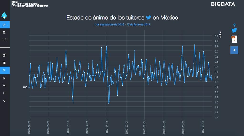
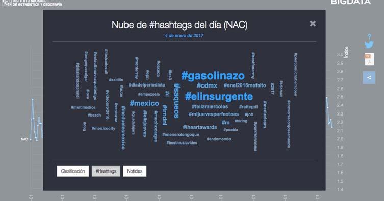
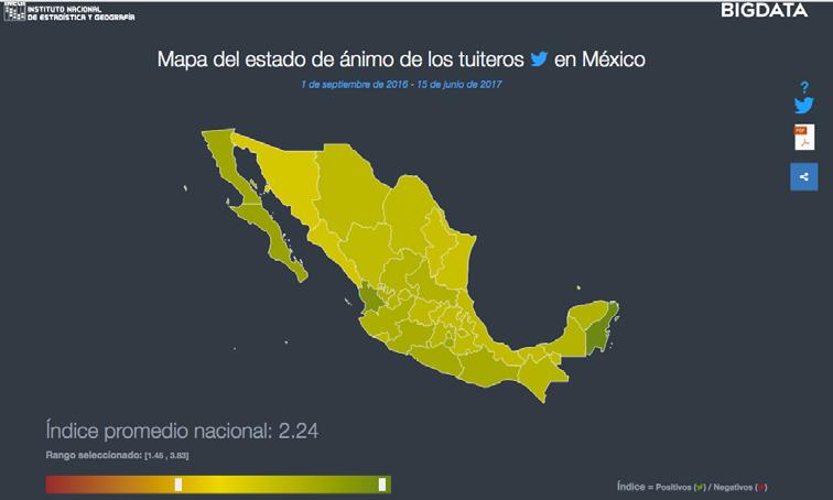
5 Some examples Big Data. Mood of tweeters Twitter / Centro Geo / INFOTEC /TecMilenio / Upenn / INEGI Mental Health of tweeters Twitter / National Institute of Psychiatry / Centro Geo / INFOTEC /TecMilenio / Upenn / INEGI Recent earthquake evaluations and early warnings system. BBVA Bancomer / Telefonica / Global Pulse / ECLAC / Presidencia de la República / INEGI Land use and vegetation carthography. LANDSAT (NASA) / CENTINEL (European Space Agency) / INEGI Income distribution. A more realistic version of income distribution trough RMPL. Tax Authority / INEGI
6 Other activities: Seminars. Micro data laboratory.

7
8

9
10 Income Distribution by deciles 100% 90% 80% 70% 60% 50% 40% 30% 20% 10% 0% 34.9% 53.8% 20.5% ENIGH GG 11.7%


11 OBJECTIVE To discuss and generate ideas around: What should be measured? How should it be done? and what are the best practices to communicate the information to the population?


12 OBJECTIVE Deepening on-going reflection on how to measure social progress and wellbeing in Latin America.


13 OBJECTIVE Discussing the merits of the new statistics on subjective wellbeing as a tool to strengthen decision-making in the public, private and social fields.


14 OBJECTIVE To showcase concrete examples of the impact of the policies, frameworks and institutions that are using wellbeing measures around the world today.


15 OBJECTIVE To discuss the existing sources and methodologies to provide the best possible description of income distribution in a given society.


16 OBJECTIVE Discussing whether there is a new paradigm of development and its implication for the definition of economic, social and environmental policies at the national level.
17 1.- Measuring Progress and Social Welfare, (2009), CIDE International Seminar: Climate Change and Official Statistics, (2009), PUMA-UNAM International Seminar: The phenomenon of informality in the XXI Century: measurement, analysis and challenges, (2010), El Colegio de México National Statistics Meeting. World Statistics Day: Celebrating the many achievements of the official statistics, (2010), IIMAS-UNAM and the Mexican Association of Statistics.
18 5.- International Seminar: Geospatial Information and decision-making: current knowledge and challenges, (2010), Centro GEO Latin American Conference on Measuring Well-being and Fostering the Progress of Societies, (2011), OCDE, FCCT, BID, CEPAL y CEA International Seminar: International Seminar: "Measurement of Vulnerable Social Groups, (2011), Instituto de Investigaciones Sociales, UNAM International Seminar: Statistical and Geographical Information for Water Management in Mexico, (2012), UAM Workshop-Seminar: Application of Small Area Estimation Techniques in the Social Sciences. (2012) CONEVAL, UIA.
19 10.- International Seminar: Statistical and Geographical Information to Prevent and Mitigate the Effects of Droughts and Floods in the Population and the Economy (2012), Instituto de Geofísica y Centro de Ciencias de la Atmósfera UNAM Seminar: Inequalities and Progress in Mexico: Scopes, Dimensions and Measurement (2013), El Colegio de México Seminar: Subjective well-being: Its measurement and use in public policies and decision-making in Mexico and Latin America (2013), FLACSO-México International Workshop on: Input-output Analysis (2013), School of Economy UNAM.
20 14.- XXVIII National Statistical Fora. In the framework of The International Year of Statistics 2013 (2013), Asociación Mexicana de Estadística The Accountability of Growth and the Total Productivity in Mexico (2013), Instituto Tecnológico Autónomo de México Big Data for Official Information and Decision Making (2014) INFOTEC Seminar-Workshop: Information for decision-making: Population and environment (2015) El Colegio de México th OECD World Forum on Statistics, Knowledge and Policy, Transforming policy, changing lives (2015) OCDE.
21 19.- International Seminar: Design, Collection and Analysis of Longitudinal Data in Mexico: An Agenda for the Future (2015) CIDE-Región Centro International Workshop-Seminar: Design and Use of Social Accounting Matrices and Computable General Equilibrium Models for Planning and Decision Making (2016) Universidad Autonoma Metropolitana (UAM), INEGI. Programa Universitario de Estudios del Desarrollo UNAM International Seminar: Income Distribution and Inequality Measurement (2016) University Program for Development Studies (UNAM), INEGI Seminar: Old-new perspectives on development? The international agenda and the SDGs (2016) El Colegio de México.
Geospatial Information Management in the Americas: Lessons for the Post-2015 development agenda
 Geospatial Information Management in the Americas: Lessons for the Post-2015 development agenda Rolando Ocampo President, UN-GGIM: Americas October 2014 The integration of statistical and geographical
Key Elements of the Geographical Information System of Mexico *
 UNITED NATIONS E/CONF.99/IP.1 ECONOMIC AND SOCIAL COUNCIL Ninth United Nations Regional Cartographic Conference for the Americas New York, 10-14 August 2009 Item 7(a) of the provisional agenda Strategy,
2018/1 The integration of statistical and geospatial information. The Regional Committee of UN-GGIM: Americas:
 The following are the conclusions and recommendations of the Regional Committee of the United Nations on Global Geospatial Information Management for the Americas, during its Fifth Session, Thursday 8
UN-GGIM: Strengthening Geospatial Capability
 Fifth Plenary Meeting of UN-GGIM: Europe Brussels, 6-7 June 2018 UN-GGIM: Strengthening Geospatial Capability Walking the talk to leave no one behind Greg Scott, UN-GGIM Secretariat Environmental Statistics
Creating synergies between Statistical and Geospatial information for better policy outputs: The case of Mexico
 Creating synergies between Statistical and Geospatial information for better policy outputs: The case of Mexico Geospatial & Statistics Integration for Informed Decision Making Geospatial World Forum 2017
The Pan American Institute of Geography and History (PAIGH) North America National Mapping Meeting May 10, 2018
 North America National Mapping Meeting May 10, 2018") The Pan American Institute of Geography and History (PAIGH) North America National Mapping Meeting May 10, 2018 Pan American Institute of Geography and History (PAIGH) PAIGH was founded in 1928 and their
The Pan American Institute of Geography and History (PAIGH) North America National Mapping Meeting May 10, 2018 Pan American Institute of Geography and History (PAIGH) PAIGH was founded in 1928 and their
KUNMING FORUM ON UNITED NATIONS GLOBAL GEOSPATIAL INFORMATION MANAGEMENT CITIES OF THE FUTURE: SMART, RESILIENT
 KUNMING FORUM ON UNITED NATIONS GLOBAL GEOSPATIAL INFORMATION MANAGEMENT CITIES OF THE FUTURE: SMART, RESILIENT and SUSTAINABLE Yunnan Zhenzhuang Guest House, Kunming, China 10 12 May 2017 BACKGROUND CONCEPT
UN-GGIM:Americas Regional Report
 UN-GGIM:Americas Regional Report 2016-2017 Seventh Session of UN-GGIM 2-4 August 2017, United Nations Headquarters, New York. Rolando Ocampo President of UN-GGIM: Americas Content Activities, Areas of
Geographical Names: Relevance and place within the UN-GGIM framework
 Geographical Names: Relevance and place within the UN-GGIM framework Greg Scott Inter-Regional Advisor Global Geospatial Information Management United Nations Statistics Division UN-GGIM: A global initiative
The Global Statistical Geospatial Framework and the Global Fundamental Geospatial Themes
 The Global Statistical Geospatial Framework and the Global Fundamental Geospatial Themes Sub-regional workshop on integration of administrative data, big data and geospatial information for the compilation
Set-up of subnational statistical systems Statistical Development Strategy for the State of Jalisco México, 2016
 Set-up of subnational statistical systems Statistical Development Strategy for the State of Jalisco México, 2016 Statistical and Geographical Information Institute of Jalisco (IIEG) 2013. Merger of three
The National Integrated Drought Information System in the Midwest
 The National Integrated Drought Information System in the Midwest Advancing Drought Science and Preparedness Across the Nation Ohio River Basin Alliance Summit Thomas More College October 19, 2018 What
Analysis of Rural-Urban Systems and Historic Climate Data in Mexico
 Analysis of Rural-Urban Systems and Historic Climate Data in Mexico Global Conference on Big Data for Official Statistics October 2015, Abu Dhabi, UAE RURAL-URBAN SYSTEMS Rural-Urban Systems: Functional
Geographic Information Infrastructure and Policy Framework for Sustainable Mountain Development in the Hindu Kush-Himalayas
 Geo SMART ASIA 2017 22-24 August, Kualalampur Geographic Information Infrastructure and Policy Framework for Sustainable Mountain Development in the Hindu Kush-Himalayas Basanta Shrestha, Director Strategic
SDG s and the role of Earth Observation
 SDG s and the role of Earth Observation Christian Heipke IPI - Institute for Photogrammetry and GeoInformation Leibniz Universität Hannover Germany Secretary General, ISPRS 1. No Poverty 2. Zero Hunger
Implementing the Sustainable Development Goals: The Role of Geospatial Technology and Innovation
 Fifth High Level Forum on UN Global Geospatial Information Management Implementing the Sustainable Development Goals: The Role of Geospatial Technology and Innovation 28-30 November 2017 Sheraton Maria
Geospatial Enabling Resilient Development. Latin America Geospatial Forum Río de Janeiro September 2013
 Geospatial Enabling Resilient Development Latin America Geospatial Forum Río de Janeiro September 2013 Presentation Index INEGI /SNIEG Geostatistical Frame - Georeferenciation Issues Legal Framework Mexican
Disaster Management & Recovery Framework: The Surveyors Response
 Disaster Management & Recovery Framework: The Surveyors Response Greg Scott Inter-Regional Advisor Global Geospatial Information Management United Nations Statistics Division Department of Economic and
PAN AMERICAN INSTITUTE OF GEOGRAPHY AND HISTORY Specialized Organization of the OAS
 PAN AMERICAN INSTITUTE OF GEOGRAPHY AND HISTORY Specialized Organization of the OAS 10 th UNRCC Americas United Nations, New York, 20 August 2013 PAIGH, SIRGAS, PC-IDEA and GeoSUR 2013-2015 Joint Action
Development Of Common Frameworks And Methodologies *
 HIGH LEVEL FORUM ON GLOBAL GEOSPATIAL MANAGEMENT INFORMATION WORKING PAPER No. 9 First Forum Seoul, Republic of Korea, 24-26 October 2011 Development Of Common Frameworks And Methodologies * * Submitted
Economic and Social Council
 United Nations Economic and Social Council Distr.: General 18 July 2016 Original: English Committee of Experts on Global Geospatial Information Management Sixth session New York, 3-5 August 2016 Item 2
The Integrated Ge spatial Information Framework to the strengthening of NSDI, Mongolia
 Young Geospatial Professionals Summit 21 NOV 2018 The Integrated Ge spatial Information Framework to the strengthening of NSDI, Mongolia BAYARMAA ENKHTUR Geospatial information and technology department
Space Applications for Disaster Risk Reduction and Sustainable Development
 Space Applications for Disaster Risk Reduction and Sustainable Development Space Applications Section (SAS) ICT and Disaster Risk Reduction Division (IDD) UNESCAP Contents I. RESAP Activities 2016-2017
NCAVES - Global initiative and national pilots
 NCAVES - Global initiative and national pilots Kavita Sharma UN Environment Pretoria, March 2018 Outline 1. Global initiative > Introduction > Objectives and deliverables >Activities in 2017 and 2018 2.
National SDG Data Hubs: Statistical integration and geographic disaggregation (Philippines)
") National SDG Data Hubs: Statistical integration and geographic disaggregation (Philippines) 5 th High Level Forum on United Nations Global Geospatial Information Management Implementing the Sustainable
National SDG Data Hubs: Statistical integration and geographic disaggregation (Philippines) 5 th High Level Forum on United Nations Global Geospatial Information Management Implementing the Sustainable
Use of administrative registers for strengthening the geostatistical framework of the Census of Agriculture in Mexico
 Use of administrative registers for strengthening the geostatistical framework of the Census of Agriculture in Mexico Susana Pérez INEGI, Dirección de Censos y Encuestas Agropecuarias. Avenida José María
Crisis Support and Disaster Response. in Latin America and the Caribbean
 Crisis Support and Disaster Response in Latin America and the Caribbean The Pan American Agenda 2010-2020 of the Pan American Institute of Geography and History (PAIGH), and the resulting 2010 Implementation
Spatially enabling e-government through geo-services
 Spatially enabling e-government through geo-services Mauro Salvemini EUROGI PRESIDENT Professor at Sapienza Università di Roma (IT) 1 About the presentation Few information about Eurogi ; Some essential
Sistema de Informacion Geografica Peninsular de Yucatan (SIGPY): WORK PLAN for the UQROO- URI GIS Development Project
: WORK PLAN for the UQROO- URI GIS Development Project") Sistema de Informacion Geografica Peninsular de Yucatan (SIGPY): WORK PLAN for the UQROO- URI GIS Development Project Eddie Ellis, UQROO 2001 Citation: Quintana Roo, Mexico: Universidad de Quintana Roo
Sistema de Informacion Geografica Peninsular de Yucatan (SIGPY): WORK PLAN for the UQROO- URI GIS Development Project Eddie Ellis, UQROO 2001 Citation: Quintana Roo, Mexico: Universidad de Quintana Roo
Experience of Mexico in using GIS and spatial
 Experience of Mexico in using GIS and spatial data as a tool for data integration Francisco Javier Jimenez Nava Deputy General Director of Natural Resources and Environment Outline Introduction National
FOURTH URBAN RESEARCH SYMPOSIUM URBAN LAND USE AND LAND MARKETS. WASHINGTON D.C., U.S.A. May 2007
 FOURTH URBAN RESEARCH SYMPOSIUM URBAN LAND USE AND LAND MARKETS WASHINGTON D.C., U.S.A. May 2007 METROPOLITAN MONTEVIDEO: LAND USES AND URBAN LAND MARKET CLUSTER 1 ISABEL VIANA URUGUAY METROPOLITAN MONTEVIDEO
Bengt Kjellson Chair of the Executive Committee UN-GGIM: Europe. 2 nd Joint UN-GGIM: Europe ESS Meeting 11 th March 2016, Luxembourg
 Bengt Kjellson Chair of the Executive Committee UN-GGIM: Europe 2 nd Joint UN-GGIM: Europe ESS Meeting 11 th March 2016, Luxembourg A global geospatial mandate At its 47th plenary in July 2011, ECOSOC,
Grounds. (*) Arouca Declaration; International Congress of Geotourism, Arouca Geopark, Portugal, Nov
 Arouca Declaration; International Congress of Geotourism, Arouca Geopark, Portugal, Nov") Grounds In the past few years, Latin America has witnessed increasing actions intended to conceive and develop geoparks, mainly as a result of the initiative promoted by the UNESCO Geoscience and Geoparks
Grounds In the past few years, Latin America has witnessed increasing actions intended to conceive and develop geoparks, mainly as a result of the initiative promoted by the UNESCO Geoscience and Geoparks
1) United Nations Committee of Experts on Global Geospatial Information Management (UN-GGIM)
 United Nations Committee of Experts on Global Geospatial Information Management (UN-GGIM)") International Workshop on Legal and Policy Frameworks for Geospatial Information Management Licensing of Geospatial Information 7 9 November 2017 Tianjin Zhengxie Club Hotel Tianjin, China Outline of presentation
International Workshop on Legal and Policy Frameworks for Geospatial Information Management Licensing of Geospatial Information 7 9 November 2017 Tianjin Zhengxie Club Hotel Tianjin, China Outline of presentation
Colin Bray, OSi CEO. Collaboration to develop a data platform for geospatial and statistical information in Ireland
 Colin Bray, OSi CEO Collaboration to develop a data platform for geospatial and statistical information in Ireland Organisations Ireland s National Mapping Agency Established in 1824 Operates under the
INTRODUCING THE EUROPEAN DIMENSION
 INTRODUCING THE EUROPEAN DIMENSION OF DANISH PLANNING ESPON/ENECON POSTGRADUATE WORKSHOP TERRITORIAL GOVERNANCE AND COOPERATION UNIVERSITY OF EASTERN FINLAND JOENSUU, FINLAND OCTOBER 19, 2012 DANIEL GALLAND
Challenges, dilemmas and commitments of a common urban agenda Executive summary
 Latin America and the Caribbean Challenges, dilemmas and commitments of a common urban agenda Executive summary Forum of Ministers and High Authorities of Housing and Urban Development of Latin America
A proposal for building an infrastructure for European geospatial statistics. Marie Haldorson, Statistics Sweden Ekkehard Petri, Eurostat
 A proposal for building an infrastructure for European geospatial statistics Marie Haldorson, Statistics Sweden Ekkehard Petri, Eurostat What is geospatial statistics? The location, extent or spatial relations
Second High Level Forum on GGIM Seminar on Regional Cooperation in Geospatial Information Management Doha, Qatar, 7 February 2013
 Second High Level Forum on GGIM Seminar on Regional Cooperation in Geospatial Information Management Doha, Qatar, 7 February 2013 Overview on Geospatial Activities in Egypt BY : Eng.Nahla Seddik Mohamed
Colin Bray, OSi CEO. Articulating the Data Needs for SDGs. Collaboration in Ireland
 Ireland Colin Bray, OSi CEO Articulating the Data Needs for SDGs Collaboration in Ireland Articulating the Data Needs for SDGs Ireland Introduction Collaboration between the Irish National Mapping Agency
A proposal for building an infrastructure for European geospatial statistics
 A proposal for building an infrastructure for European geospatial statistics Marie Haldorson, Statistics Sweden Ekkehard Petri, Eurostat What is geospatial statistics? The location, extent or spatial relations
Egypt Public DSS. the right of access to information. Mohamed Ramadan, Ph.D. [R&D Advisor to the president of CAPMAS]
![Egypt Public DSS. the right of access to information. Mohamed Ramadan, Ph.D. [R&D Advisor to the president of CAPMAS]](/thumbs/89/98483713.jpg "Egypt Public DSS. the right of access to information. Mohamed Ramadan, Ph.D. [R&D Advisor to the president of CAPMAS]") Egypt Public DSS ì the right of access to information Central Agency for Public Mobilization and Statistics Arab Republic of Egypt Mohamed Ramadan, Ph.D. [R&D Advisor to the president of CAPMAS] Egypt
Egypt Public DSS ì the right of access to information Central Agency for Public Mobilization and Statistics Arab Republic of Egypt Mohamed Ramadan, Ph.D. [R&D Advisor to the president of CAPMAS] Egypt
Achieving the Vision Geo-statistical integration addressing South Africa s Developmental Agenda. geospatial + statistics. The Data Revolution
 Achieving the Vision Geo-statistical integration addressing South Africa s Developmental Agenda geospatial + statistics The Data Revolution humble beginnings, present & future - South Africa UN World Data
Working Group on Geospatial Information
 GEO-XIV Plenary Summary Working Group on Geospatial Information 4 th Meeting Lawrence Friedl Argyro Kavvada Group on Earth Observations NASA Earth Science Dec. 6-8, 2017 An intergovernmental organization
Building Institutional Capacity for Multi-Hazard Early Warning in Asia and the Pacific Subtitle
 Building Institutional Capacity for Multi-Hazard Early Warning in Asia and the Pacific Subtitle Title Keran Wang Chief, Space Applications Section ICT and Disaster Risk Reduction Division 22 May 2018 Pillar
UN-GGIM: An Overview Stefan Schweinfest, Director (UNSD) Bangkok, 27 March 2015
 Bangkok, 27 March 2015") UN-GGIM: An Overview Stefan Schweinfest, Director (UNSD) Bangkok, 27 March 2015 ggim.un.org UN-GGIM: A global initiative Formal inter-governmental UN Committee of Experts to: Discuss, enhance and coordinate
UN-GGIM: An Overview Stefan Schweinfest, Director (UNSD) Bangkok, 27 March 2015 ggim.un.org UN-GGIM: A global initiative Formal inter-governmental UN Committee of Experts to: Discuss, enhance and coordinate
CES Seminar 2016: Geospatial information services based on official statistics Key issues from the session II papers
 Norbert Rainer 64 th plenary session of the Conference of European Statisticians 28 April 2016, Paris CES Seminar 2016: Geospatial information services based on official statistics Key issues from the
COURSE SYLLABUS. Urban Development Theories Jan Fransen (IHS EUR), Dritan Shutina (POLIS) Total in class hours. 1. General Course Description
, Dritan Shutina (POLIS) Total in class hours. 1. General Course Description") COURSE SYLLABUS Subject: Lecturer: Urban Development Theories Jan Fransen (IHS EUR), Dritan Shutina (POLIS) Lectures Exercises Discussions Total in class hours Assignment Credits 7 hours 7 hours 4 hours
COURSE SYLLABUS Subject: Lecturer: Urban Development Theories Jan Fransen (IHS EUR), Dritan Shutina (POLIS) Lectures Exercises Discussions Total in class hours Assignment Credits 7 hours 7 hours 4 hours
KENYA NATIONAL BUREAU OF STATISTICS Workshop on
 KENYA NATIONAL BUREAU OF STATISTICS Workshop on Capacity Building in Environment Statistics: the Framework for the Development of Environment Statistics (FDES 2013) Coordination with Sector Ministries
FINDINGS OF THE ARCTIC METEOROLOGY SUMMIT
 FINDINGS OF THE ARCTIC METEOROLOGY SUMMIT 2018 WWW.FMI.FI CHAIR S SUMMARY: 1 2 3 We need to be curious to explore the known unknowns. Meteorology is an elemental part of international collaboration in
Realizing benefits of Spatial Data Infrastructure A user s perspective from Environment Agency - Abu Dhabi
 Realizing benefits of Spatial Data Infrastructure A user s perspective from Environment Agency - Abu Dhabi Anil Kumar Director, Environment Information Management 26 April 2012 Geospatial World Forum,
Institute of Statistical and Geographical Information of Jalisco State Subnational Statistical and Geographical System India.
 Institute of Statistical and Geographical Information of Jalisco State Subnational Statistical and Geographical System India. January 2017 Subnational Statistical and Geographical System National Statistical
Centro Internacional para la Investigación del Fenómeno de El Niño
 Centro Internacional para la Investigación del Fenómeno de El Niño www.ciifen.org Role of South American Regional Climate Centers on Drought Rodney Martínez r.martinez@ciifen.org Workshop: Towards a Drought
Economic and Social Council
 United Nation E/C.20/2012/4/Add.1 Economic and Social Council Distr.: General 2 July 2012 Original: English Committee of Experts on Global Geospatial Information Management Second session New York, 13-15
Capacity Building Activities at CRECTEALC. Ing. Jerjes Molina Blancas Professor and Developer.
 Capacity Building Activities at CRECTEALC Ing. Jerjes Molina Blancas Professor and Developer. Centro Regional de Enseñanza de Ciencia y Tecnología del Espacio para América Latina y el Caribe (CRECTEALC)
Integration for Informed Decision Making
 Geospatial and Statistics Policy Intervention: Integration for Informed Decision Making Greg Scott Global Geospatial Information Management United Nations Statistics Division Department of Economic and
Section 2. Indiana Geographic Information Council: Strategic Plan
 Section 2. Indiana Geographic Information Council: Strategic Plan Introduction A geographic information system (GIS) is an automated tool that allows the collection, modification, storage, analysis, and
Institute of Statistical and Geographical Information of Jalisco State Geospatial Technologies, platforms and services at a subnational level
 Institute of Statistical and Geographical Information of Jalisco State Geospatial Technologies, platforms and services at a subnational level México, November 2017 Unique organization in its type SDG 17.18:
PURR: POTENTIAL OF RURAL REGIONS UK ESPON WORKSHOP Newcastle 23 rd November Neil Adams
 PURR: POTENTIAL OF RURAL REGIONS UK ESPON WORKSHOP Newcastle 23 rd November 2012 Neil Adams PURR: Potential of Rural Regions Introduction Context for the project A spectrum of knowledge Rural Potentials
ESCAP Promotes Geo-referenced Information System for Disaster Risk Management in Asia and the Pacific
 Third High Level Forum on UNGGIM 22-24 October 2014 Beijing, China ESCAP Promotes Geo-referenced Information System for Disaster Risk Management in Asia and the Pacific Keran Wang Space Applications Section,
Economic and Social Council
 United Nations Economic and Social Council Distr.: General 2 July 2012 E/C.20/2012/10/Add.1 Original: English Committee of Experts on Global Geospatial Information Management Second session New York, 13-15
Pathways. Pathways through the Geography Major
 Pathways through the Major majors may structure their course selections around a sub-field of. Pathways are suggestions for classes in, in related disciplines, and skills training. Each pathway includes
International Workshop on Legal and Policy Frameworks for Geospatial Information Management: Licensing of Geospatial Information
 United Nations Committee of Experts on Global Geospatial Information Management International Workshop on Legal and Policy Frameworks for Geospatial Information Management: Licensing of Geospatial Information
CONFERENCE STATEMENT
 Final draft CONFERENCE STATEMENT We, the elected representatives of Canada, Denmark/Greenland, the European Parliament, Finland, Iceland, Norway, Russia, Sweden and the United States of America; In collaboration
Emerging issues to use geospatial initiatives in the societal context of disaster managing **
 ADVANCE UNEDITED VERSION UNITED NATIONS E/CONF.103/3/Add.1 ECONOMIC AND SOCIAL COUNCIL Tenth United Nations Regional Cartographic Conference for the Americas New York, 19-23, August 2013 Item 6 (a) of
ACTION PLAN FOR WORLD HERITAGE IN LATIN AMERICA AND THE CARIBBEAN ( )
") Annex ACTION PLAN FOR WORLD HERITAGE IN LATIN AMERICA AND THE CARIBBEAN (2014-2024) The current Regional Action Plan for Latin America and the Caribbean for 2014-2024 has been elaborated by the State Parties
Annex ACTION PLAN FOR WORLD HERITAGE IN LATIN AMERICA AND THE CARIBBEAN (2014-2024) The current Regional Action Plan for Latin America and the Caribbean for 2014-2024 has been elaborated by the State Parties
Sustainability Science: The State of the Field
 Sustainability Science: The State of the Field Presented to The Sustainability Science Fellows Seminar Harvard University Sept. 17, 2012 by William C. Clark Sustainable Development Sustainable Development:
GOVERNMENT MAPPING WORKSHOP RECOVER Edmonton s Urban Wellness Plan Mapping Workshop December 4, 2017
 GOVERNMENT MAPPING WORKSHOP 12.4.17 RECOVER Edmonton s Urban Wellness Plan Mapping Workshop December 4, 2017 In July of 2017, City Council directed administration to develop RECOVER, Edmonton s Urban Wellness
INTEGRATING CLIMATE VULNERABILITY & RISK ASSESSMENT INTO URBAN SPATIAL PLANNING PROCESS
 INTEGRATING CLIMATE VULNERABILITY & RISK ASSESSMENT INTO URBAN SPATIAL PLANNING PROCESS (CASE STUDY: BLITAR CITY, EAST JAVA, INDONESIA) SHINTA MICHIKO PUTERI, ST, MT. DR. IR. DENNY ZULKAIDI, MUP. WRITER
Geospatial Policy Development and Institutional Arrangements *
 HIGH LEVEL FORUM ON GLOBAL GEOSPATIAL MANAGEMENT INFORMATION WORKING PAPER No. 13 First Forum Seoul, Republic of Korea, 24-26 October 2011 Geospatial Policy Development and Institutional Arrangements *
Proposed Scope of Work Village of Farmingdale Downtown Farmingdale BOA Step 2 BOA Nomination Study / Draft Generic Environmental Impact Statement
 Proposed Scope of Work Village of Farmingdale Downtown Farmingdale BOA Step 2 BOA Nomination Study / Draft Generic Environmental Impact Statement The scope of work that follows incorporates and covers
The role of community in urban regeneration: mixed use areas approach in USA
 The role of community in urban regeneration: mixed use areas approach in USA Outline 1. Thesis 2. Main topics 3. Urban regeneration and community 4. Community involvement methods 5. Policies: EU vs USA
have been a number of high level and expert reviews including the most recent, the Marmot review.
 QUESTIONS 5. Role of GPs and GP practices in public health: Are there additional ways in which we can ensure that GPs and GP practices will continue to play a key role in areas for which Public Health
Scenario development for reaching urban and environmental planning integration in the context of climate change*.
 Scenario development for reaching urban and environmental planning integration in the context of climate change*. PhD (cand) Verónica Zagare (TUDelft, ) Dr. Diego Sepúlveda Carmona (TUDelft) September
Brazil Paper for the. Second Preparatory Meeting of the Proposed United Nations Committee of Experts on Global Geographic Information Management
 Brazil Paper for the Second Preparatory Meeting of the Proposed United Nations Committee of Experts on Global Geographic Information Management on Data Integration Introduction The quick development of
GENERAL RECOMMENDATIONS. Session 7. Breakout discussion. discuss on regional and interregional. proposals 1. COLLABORATION BETWEEN PROGRAMMES
 Session 7 24 July 2016, 9.00-11.00 Breakout discussion on regional and interregional joint project proposals Mr Shahbaz Khan summarized the two days of presentations and exchanges and requested the participants
TERMS OF REFERENCE CONSULTANCY TO DEVELOP CLIMATE PRODUCTS AND SERVICES FOR THE CARIBBEAN TOURISM INDUSTRY (FEASIBILITY STUDY)
") Appendix 2 TERMS OF REFERENCE CONSULTANCY TO DEVELOP CLIMATE PRODUCTS AND SERVICES FOR THE CARIBBEAN TOURISM INDUSTRY (FEASIBILITY STUDY) 1. BACKGROUND 1.01 The Caribbean tourism product depends largely
Appendix 2 TERMS OF REFERENCE CONSULTANCY TO DEVELOP CLIMATE PRODUCTS AND SERVICES FOR THE CARIBBEAN TOURISM INDUSTRY (FEASIBILITY STUDY) 1. BACKGROUND 1.01 The Caribbean tourism product depends largely
Disaster Risk Reduction UNESCO s contribution to a global challenge
 Educational, Scientific Cultural Organization Disaster Risk Reduction UNESCO s contribution to a global challenge aming gas crater known as the Door to Hell in Darvaza, Turkmenistan. Shutterstock / Lockenes
Workshop B Spatial positioning and definition of characteristics
 This presentation expresses the author's views. It does not necessarily reflect the opinion of the ESPON Monitoring Committee, which is not liable for any use that may be made of the information provided.
Economic Benefit Study on Value of Spatial Information Australian Experience
 Economic Benefit Study on Value of Spatial Information Australian Experience Dr Zaffar Sadiq Mohamed-Ghouse Director, International Relations Cooperative Research Centre for Spatial Information zsadiq@crcsi.com.au
UN GGIM and National SDI Strategy
 MSDI Open Forum on 26 th January 2016 Contributing to the successful delivery of MSDI UN GGIM and National SDI Strategy Hiroshi Murakami Deputy Administrator Geospatial Information Authority of Japan Geospatial
Sustainable tourism in for Sustaibale Danang
 Sustainable tourism in for Sustaibale Danang A case study of Balearic Ecotax in Spain toward Sustainable tourism Miki Yoshizumi Associate Professor College of Gastronomy Management Ritsumeikan University
Geospatial activities during the 47 th UN Statistical Commission
 Geospatial activities during the 47 th UN Statistical Commission A Summary Rolando Ocampo Alcántar April 2016 47 th Session of the United Nations Statistical Commission Side Events Friday Seminar on Emerging
Innovation and modernization of national statistical systems through trusted data collaboratives
 Innovation and modernization of national statistical systems through trusted data collaboratives Carlos Felipe Prada Deputy Director Bogotá, Colombia November 2017 www.dane.gov.co The Colombian National
Conference on Urban Development Strategies in the Mediterranean Barcelona, March 14-15, 2011
 Analysing Urban Development Strategies: the OECD Approach by Adam Knelman Ostry Counsellor, Regional Development Policy adam.ostry@oecd.org Conference on Urban Development Strategies in the Mediterranean
Concept note. High-Level Seminar: Accelerating Sustainable Energy for All in Landlocked Developing Countries through Innovative Partnerships
 Concept note High-Level Seminar: Accelerating Sustainable Energy for All in Landlocked Developing Countries through Innovative Partnerships Date: 24 and 25 October 2016 Venue: Conference Room C3, Vienna
A science-policy approach towards local adaptation planning: The case of Santiago de Chile
 A science-policy approach towards local adaptation planning: The case of Santiago de Chile Kerstin Krellenberg, PhD Resilient Cities 2011 2nd World Congress on Cities and Adaptation to Climate Change Bonn,
Reducing Vulnerability to Extreme Heat: Science-Policy Interface
 Reducing Vulnerability to Extreme Heat: Science-Policy Interface Olga Wilhelmi, Mary Hayden, Jennifer Boehnert, Ursula Lauper and SIMMER research team October 23, 2013 Toronto SIMMER workshop Science-Policy
Environmentally-induced Population Displacements: Conclusions from PERN s Online Seminar
 Environment, Forced Migration & Social Vulnerability International Conference 9-11 October 2008 Bonn, Germany www.efmsv2008.org Environmentally-induced Population Displacements: Conclusions from PERN s
OSS MISSION.
 GEO-CRADLE COORDINATING AND INTEGRATING STATE-OF-THE-ART EARTH OBSERVATION ACTIVITIES IN THE REGION OF NORTH OF AFRICA, MIDDLE EAST, AND BALKANS AND DEVELOPING LINKS WITH GEO RELATED INITIATIVES TOWARD
Progress on the Development of the Strategic Framework on Geospatial Information and Services for Disasters
 Progress on the Development of the Strategic Framework on Geospatial Information and Services for Disasters Dr. Peter N. Tiangco Administrator, NAMRIA, Philippines Co-chair, Working Group on Geospatial
Disaster Prevention and Management in Asia: The Context of Human Security and Its Relevance to Infrastructure Planning and Management
 Disaster Prevention and Management in Asia: The Context of Human Security and Its Relevance to Infrastructure Planning and Management Rajib Shaw http://www.iedm.ges.kyoto-u.ac.jp/ Contents Background and
Global Spatial Data Infrastructure Association
 http://www.gsdi.org Global Spatial Data Infrastructure Association a global forum to support exchange of ideas and encourage joint activities at the global level Members: Think global, act local Organization:
INSTITUTIONAL BRIEF National Secretariat for Housing and Habitat
 INSTITUTIONAL BRIEF National Secretariat for Housing and Habitat Minister Soledad Nuñez @solenu www.senavitat.gov.py ASUNCION, PARAGUAY PARAGUAY LOCATION Landlocked with dry and wet borders PARAGUAY KEY
Geospatial Information and Services for Disasters (GIS4D)
") Geospatial Information and Services for Disasters (GIS4D) 31 July 2017 Tae Hyung KIM ICT and Disaster Risk Reduction Division (IDD) UNESCAP 1 About ESCAP Who is ESCAP? United Nations Economic and Social
Geospatial Information and Services for Disasters (GIS4D) 31 July 2017 Tae Hyung KIM ICT and Disaster Risk Reduction Division (IDD) UNESCAP 1 About ESCAP Who is ESCAP? United Nations Economic and Social
Towards a National Ecosystem Services Strategy for Australia
 Towards a National Ecosystem Services Strategy for Australia Peter Ampt, Simone Maynard, Geoff Gorrie, Philippa Rowland, Allan Dale, Jeremy Thompson, Steve Cork, Bob Douglas, Lynne Reeder Australia 21
RESAP Progress Report
 RESAP Progress Report December 2016 to October 2017 Presentation to the Twenty-first session of the Intergovernmental Consultative Committee on the Regional Space Applications Programme for Sustainable
Modern Urban and Regional Economics
 Modern Urban and Regional Economics SECOND EDITION Philip McCann OXFORD UNIVERSITY PRESS Contents List of figures List of tables Introduction xii xiv xvii Part I Urban and Regional Economic Models and
Spatial Planning & Climate Change
 Spatial Planning & Climate Change A GRIP Approach Joseph Scott, Glasgow & Clyde Valley Strategic Development Plan Authority, Scotland Today s presentation Context Spatial Planning & Climate Change Exploring
Territorial Intelligence and Innovation for the Socio-Ecological Transition
 Territorial Intelligence and Innovation for the Socio-Ecological Transition Jean-Jacques Girardot, Evelyne Brunau To cite this version: Jean-Jacques Girardot, Evelyne Brunau. Territorial Intelligence and