The Christopher Columbus Chart #257
|
|
|
- Alannah Willis
- 6 years ago
- Views:
Transcription

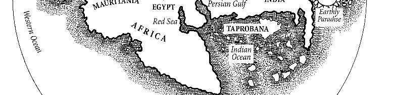
1 TITLE: The Christopher Columbus Chart DATE: AUTHOR: Christopher Columbus DESCRIPTION: In 1924, Charles de La Ronciere, the renowned French historian of exploration and cartography, attributed to Christopher Columbus a portolan [nautical] sea chart that has been discussed and debated ever since. Although Columbus and his brother Bartholomew were accomplished mapmakers, scholars have been frustrated in their attempts to confirm who actually created this unsigned document, originally acquired by the French national library in the 19 th century. However, Columbus career as a mapmaker rests on flimsy evidence, but not that of his brother Bartholomew. Christopher Columbus probably did not learn this skill in Genoa, where the once-thriving map trade had fallen on hard times, for in 1472 he was describing himself as a lanerius [wool-worker]. In Lisbon he may have sold maps as a dealer, and, as a sailor, he naturally was familiar with the use of maps. He may have commissioned maps to be made and added information from his own experience. In his notes to d Ailly s Imago Mundi (see #238), he makes several references to our maps, but these could just as well be maps in his possession as maps he had made himself. As Gaetano Ferro has pointed out, the only surviving map that can be securely assigned to Columbus is his sketch map of Haiti (#304, Book IV). This map is unsigned and was acquired by the library in 1848 from an unknown source. The main part of the large sheet of parchment is taken up with a sea chart of the known world, from the Congo River in Africa in the southwest to the Tanais [Don] River north of the Black Sea to the northeast. It also shows Iceland and the Red Sea. In the upper left-hand corner is a circular world map, centering on Jerusalem, surrounded by the celestial spheres, with two texts taken from Pierre d Ailly describing the composition of the universe. The celestial rings symbolize the geocentric concept of the universe, commonly accepted at that time. The small (20 cm in diameter, or eight inches) world map displays some 250 place-names, and unlike the sea chart, shows all of Africa, including the results of Dias voyage - the discovery of the Cape of Good Hope and the premise that one could sail around Africa into the Indian Ocean. These details indicate that the map was drawn after 1488 and presumably before The mappamundi also shows Paradise as an island east of the Asian continent. The place-names and inscriptions are in Latin. It is most unusual to have a practical navigator s chart juxtaposed with a cosmographical plan. One of the accompanying lengthy notes in Latin announces that the world map, or mappamundi although drawn on a plane, should be considered spherical. Displaying the earth in this manner underscores the transitional character of the map from medieval to Renaissance thinking. This circular mappamundi is also noteworthy for showing southern and eastern Africa more accurately than does either the Martellus map or the Behaim globe (#256 and #258). It implies that information is included from Vasco da Gama, the Portuguese navigator who discovered a route to India, even though he did not return to Europe until The treatment of the west, south, and east coasts of Africa suggests the map s Portuguese origin. Latin is used for the numerous lengthy annotations. The 250 place- 1
2 names, however, appear in their Portuguese form, and many Portuguese-controlled areas display the Lusitanian flag. A reference at the Cape Verde Islands mentions their discovery by the Genoese, an intriguing fact considering Columbus birthplace. De la Ronciere presented this map with great enthusiasm at a meeting of the International Congress of Geographers in Cairo in April In support of his thesis, he cited the prominent vignette for the city of Genoa and a reference to the Genoese discoverer of the Cape Verde Islands. The famous map historian Marcel Destombes agrees that the script on the map is Genoese. De la Ronciere says that the map also reveals the preoccupations of a commercial traveler, such as Columbus was, showing where wheat could be grown and where it needed to be imported, and citing the availability of other trade goods, such as ostrich plumes, cotton, sugar, pepper, civet, and parrots. The maker of the map also displays much interest in places where gold might be found. The mappamundi makes it clear that the voyage to the Indies going around Africa, though feasible, was very long, a view reinforced by an inscription describing the three-year voyage of Solomon s fleet, going and returning from Ophir. This subject had greatly interested Columbus and was mentioned in a note he wrote in his copy of d Ailly s book. De la Ronciere also points to the Island of the Seven Cities, the Antilles, accompanied on the sea chart by a description of an accidental encounter there; the cabin boys of a Spanish ship, scrubbing their kitchen utensils on the beach, found silver in the sand. De la Ronciere thinks that this story inspired Columbus, and there is evidence from his journal that he had on board a map that showed the Antilles, one of the goals of his expedition. Also important to a would-be explorer, the map makes it clear that the earth is habitable and the sea navigable in the equatorial and polar zones. Finally, de la Ronciere refers to Columbus notes in d Ailly s book pointing specifically to our maps on paper where there is a sphere. Although sea atlases sometimes contained world maps, the configuration of the Columbus map with its round world map on the same sheet, is unusual. Summing up, de la Ronciere says, A more or less felicitous mishmash of archaic terms and modern nomenclature, of theory and reality, of established facts and discoveries assumed before they happened, this strange model is that of the maps of Christopher Columbus. More recently Monique Pelletier reviewed the evidence for the Columbus map, confirming that it is in fact a showcase for many of Columbus ideas. She describes it as a fine presentation copy, perhaps designed for unveiling before the Spanish monarchs at the final, and victorious, hearing at Santa Fe. It is difficult, however, to explain away the absence of Cipangu [Japan] on the world map, since that island was key to Columbus route. Instead, several islands identified with St. Brendan float vaguely in the ocean northeast of Asia. All we can conclude is that St. Brendan s adventures, usually located in the North Atlantic, have drifted to the North Pacific, perhaps another piece of evidence of the small sea between Spain and India. There is, however, no hard evidence to link it with Columbus, either as author or owner. The sea chart displays a classic delineation of the greater Mediterranean area, supplemented by the Atlantic coast stretching from southern Scandinavia to the mouth of the Congo River (named Rio Poderoso by Diogo Cao in 1484). It has particularly rich nomenclature down the African coast, where Columbus is thought to have made at least one voyage with the Portuguese. To the east, the Black Sea and Red Sea are included. Westward is a series of islands some real, some imaginary, from the Arctic to the Gulf of Guinea. Below the compass rose in the North Atlantic lie three islands, Isles of the Seven Cities. This was the Portuguese name for the islands that other Europeans called Antilia. 2
3 The surviving remains of Columbus library include his revelatory marginal notes, particularly in his copy of Cardinal d Ailly's cosmography, Imago Mundi. Monique de La Ronciere, having researched these notes, pointed out that Columbus referred to his four charts on paper, all of which also contain a sphere. She also noted an error in the inscription on this chart, next to the Red Sea, which is identical to an error in one of Columbus marginal notes. The Spanish flag flying over Granada implies the map was completed after January 1492, when Spain captured that city from the Moors. There was no attempt to show the new discoveries reported from 1493 onward, as recorded on the Juan de La Cosa planisphere of 1500 (Book IV, #305) and those which followed. This fact suggests a date for this map no later than the early 1490s. It appears questionable that a chart with this degree of professional finish and decoration, heightened with gold and including elaborate vignettes of selected major European cities, was actually executed by Christopher Columbus or his brother, Bartholomew. The style and emphasis do not appear to support the assertion. Certainly it could have been commissioned by Columbus, and his Portuguese contacts could have provided the new information, which had to have originated in Lisbon. The chart, with its mappamundi inset, remains a remarkable document of the discovery period. Although the attribution to the Admiral by the French scholars has merit, it has never been confirmed. The elongated part of the parchment shows a small, circular mappamundi with Jerusalem in the middle, surrounded by heavenly geocentric rings symbolizing the concept of the universe. LOCATION: Bibliothèque Nationale de France (CPL GE AA 562 RES) SIZE: 70 x 110 cm (28 x 44 inches); mappamundi 20 cm/8 inches diameter REFERENCES: *Destombes, M., Mappemunde, A.D , #51:26. *Edson, E., The World Map , pp , Fig *Fite & Freeman, A Book of Old Maps..., #3. *Gross, J., The Mapmaker s Art, p. 72, Plate *Nebenzahl, K., Atlas of Columbus, p. 25, Plate 8. *Scafi, A., Mapping Paradise, pp Plate 1. *illustrated 3

4 The Christopher Columbus Chart 4

5 Detailed section of North Africa 5

6 Detailed view of the appended mappamundi 6

7 7
South America: A Map Mystery Completed By:
 South America: A Map Mystery Completed By: Historians who study old maps have to be detectives. Even though the people of the past can t directly tell us what they thought or believed, they left clues
South America: A Map Mystery Completed By:
 South America: A Map Mystery Completed By: Historians who study old maps have to be detectives. Even though the people of the past can t directly tell us what they thought or believed, they left clues
Geocarta Nautica Universale #333.1
 Title: Geocarta Nautica Universale Date: 1523 Author: Giovanni [Juan] Vespucci Description: This large map is attributed to Giovanni [Juan] Vespucci, born in Florence in 1486, who was the nephew of the
Understanding Projections
 GEOGRAPHY SKILLS 1 Understanding Projections The earth is a sphere and is best shown as a globe. For books and posters, though, the earth has to be represented as a flat object. To do this, mapmakers create
This assignment is due at the start of class on Friday 3/1.
 The Age of Exploration - DOCUMENT ANALYSIS Explanation As we begin our study of how to write the Document Based Essay for the AP World History exam, it is important to realize that the documents you will
GEOGRAPHY. Map Skills. Mrs. Pere ~ 2013
 GEOGRAPHY Map Skills Mrs. Pere ~ 2013 WHAT IS A GLOBE? A globe is a model of the Earth. North Pole Equator South Pole WHAT IS A MAP? A map is a flat drawing of a place. THE IMPORTANT PARTS OF A MAP 1.
MAP SET. BrITAIN S & EXCERPTS. Norman B. Leventhal Map Center Digital Collections leventhalmap.org
 MAP SET BrITAIN S NORTH AMERICAN EMPIRE 1607 1764 Worksheets & EXCERPTS Norman B. Leventhal Map Center Digital Collections leventhalmap.org MAP 1 New england 1675 MAP Inquiry WORKSHEET Circle which of
Map Skills: Continents and Oceans. Map Skills: Continents and Oceans
 Map Skills: Continents and Oceans Our Earth is made up of continents and oceans. A continent is an enormous mass of land. There are seven continents on our planet. The continents include North America,
The Renaissance sets the stage for sustained ocean exploration
 Olli Ocean Exploration The Renaissance sets the stage for sustained ocean exploration Marvin Falk The sustained exploration of the earth s ocean required a system for preservation, accumulation, and dissemination
History of Oceanography. Unit 2
 History of Oceanography Unit 2 I. Prehistoric man 1 st concern of ancient man was for survival Archeological digs of coastal areas have found shells in refuse piles along with bones of some deep sea creatures.
INTERNATIONAL INDIAN SCHOOL, RIYADH HALF YEARLY
 INTERNATIONAL INDIAN SCHOOL, RIYADH HALF YEARLY 2018-19 STD V Fill in the blanks: WORKSHEET LESSON - 1 KNOW YOUR PLANET SOCIAL STUDIES 1 A book containing maps is called an _ 2 A Flemish map maker, collection
2011, 1998, 1987 Copyright by Remedia Publications, Inc. All Rights Reserved. Printed in the U.S.A.
 See the world REM 129A A Teaching Resource From 2011, 1998, 1987 Copyright by Remedia Publications, Inc. All Rights Reserved. Printed in the U.S.A. The purchase of this product entitles the individual
Oceans. Places. People
 Places 1 If we look at our planet from a long way away, it is. a red b yellow c white d blue 2 The nearest place to Easter Island is. a Pitcairn b Chile c Australia d Tahiti 3 Near Oceania is a group of
Map Skills Unit. Note taking unit
 Map Skills Unit Note taking unit Introduction To learn about the Earth, we are going to learn about two geographic tools you can use.globes and maps. Globe A globe is a round model of the planet Earth
Smyth County Schools Curriculum Map. 1st 6 Weeks 2nd 6 Weeks 3rd 6 Weeks 3.5 a, b, & e, , 3.10 a,b, &c, 3.11, , 3.2, 3.4, 3.
 Standards Grade: 3rd Subject: 1st 6 Weeks 2nd 6 Weeks 3rd 6 Weeks 3.5 a, b, & e, 3.6 3.6, 3.10 a,b, &c, 3.11, 312 3.1, 3.2, 3.4, 3.6 all Content STANDARD 3.5 The student will develop map skills by a) positioning
Oceanography Exercise 1 Time Line of Ocean Exploration
 NAME Oceanography Exercise 1 Time Line of Ocean Exploration Match the persons or groups listed below with the technological advance or accomplishment in the history of ocean exploration. Some names may
News English.com Ready-to-use ESL / EFL Lessons
 www.breaking News English.com Ready-to-use ESL / EFL Lessons The Breaking News English.com Resource Book 1,000 Ideas & Activities For Language Teachers http://www.breakingnewsenglish.com/book.html Map
GEOGRAPHY SOURCING PRACTICE
 What did people in the 1300s know about the size and location of important European countries and cities? This map was created using an earlier map that was part of a popular encyclopedia published between
Cardinal and Intermediate Directions:
 Name Period Parent Signature Due Date: (TBA) Geography/Map Skills Study Guide Continents and Oceans of the World: Label the continents (7) and oceans (4) on the lines below the map. 1 11 3 5 4 8 2 9 10
universal Atlas of Fernão Vaz Dourado / Vallard atlas / Atlas Miller /
 universal Atlas of Fernão Vaz Dourado / Vallard atlas / Atlas Miller / Unique and unrepeatable first editions, strictly limited to 987 numbered and authenticated copies Universal Atlas of Fernão Vaz Dourado
4th Grade US Regional Geography First Nine Weeks
 4th Grade US Regional Geography First Nine Weeks 2014-2015 Identify the choice that best completes the statement or answers the question. 1 The line identified as 0 runs west and east on the globe and
Written in Stone UNIT 2 WEEK 1. Read the article Written in Stone before answering Numbers 1 through 5. Weekly Assessment Unit 2, Week 1 Grade 6 61
 Read the article Written in Stone before answering Numbers 1 through 5. UNIT 2 WEEK 1 Written in Stone People need to communicate. The earliest human beings most likely communicated with sounds and gestures.
Learning Target : Describe the purposes and uses of different types of maps.
 Learning Target : Describe the purposes and uses of different types of maps. Directions: 1. Below, place a where you think you are located. 2. In which continent are you located? 3. In which country are
Into the Wide Blue Yonder HISTORY OF OCEAN EXPLORATION
 Into the Wide Blue Yonder HISTORY OF OCEAN EXPLORATION 3 MAIN REASONS FOR SEAFARING Food Trade Discovery of new land ANCIENT SEAFARING Biblically Noah s Ark and similar stories of floods: Not really out
Teachers Curriculum Institute Map Skills Toolkit 411
 Map kills Toolkit To the Teacher tudents encounter maps every day inside and outside their classes in books and on handheld devices, computers, or television screens. Whether they re navigating cities
Year 34 B2 Geography - Continents and Oceans 2018 Key Skills to be covered: Taken from Level 3 Taken from Level 4
 Key Skills to be covered: Taken from Level 3 Taken from Level 4 Geographical Enquiry: I ask, Which PHYSICAL features does this place have? I ask, Which HUMAN features does this place have? I give reasons
Issue of the Name of the Sea of Japan. Overview of study of maps possessed by the Bibliotheque Nationale de France
 Issue of the Name of the Sea of Japan Overview of study of maps possessed by the Bibliotheque Nationale de France (March 2004) From October 2003 to January 2004, the Ministry of Foreign Affairs of Japan
Christopher Columbus s first voyage across the Atlantic (and back to Spain) August 3,1492 to March 4, 1493
 August 3,1492 to March 4, 1493") Christopher Columbus s first voyage across the Atlantic (and back to Spain) August 3,1492 to March 4, 1493 2005 Wadsworth Thomson Christopher Columbus s first trip across the Atlantic Ocean was a pretty
Christopher Columbus s first voyage across the Atlantic (and back to Spain) August 3,1492 to March 4, 1493 2005 Wadsworth Thomson Christopher Columbus s first trip across the Atlantic Ocean was a pretty
Unit 1: Geography. For additional information, refer to this website: 1 G e o g r a p h y
 Unit 1: Geography For additional information, refer to this website: http://mryoungtms.weebly.com/ 1 G e o g r a p h y Continents and Oceans SOL USI. 2a Essential Understanding: Continents are large land
 Name Period Parent Signature Geography/Map Skills Study Guide *For extra practice with these skills, check out Mr. Kath s website: http://rkath.weebly.com/activities--links.html Continents and Oceans of
Downloaded from
 I II III IV V VI Define the following terms:- a) Orbitb) Meteoroids c) Celestial bodies GEOGRAPHY ASSIGNMENTS The Earth In The Solar System d) Satellite e) Comets Give one word answers:- a) Blue planet
Introduction to the Seafloor. Follow the steps below while taking notes in your science notebook.
 Procedure Follow the steps below while taking notes in your science notebook. 1. Name and locate all of the continents. 2. Identify linear (straight-line) and arcuate (curved-line) features on the continents.
The Middle Ages. Fleur-de-lis Earliest printed T-O map, /20/2011. T-O map. Charlemagne, King of the Franks ( )
") The Middle Ages The state of European cartography T-O maps and mappa mundi East Asian contacts The Islamic realm Portolan charts The rediscovery of Ptolemy Improvements in navigation The 1400 s Charlemagne,
The Middle Ages The state of European cartography T-O maps and mappa mundi East Asian contacts The Islamic realm Portolan charts The rediscovery of Ptolemy Improvements in navigation The 1400 s Charlemagne,
Many Ways to Name a Place
 Your web browser (Safari 7) is out of date. For more security, comfort and Activityapply the best experience on this site: Update your browser Ignore Many Ways to Name a Place What are the names for the
World Geography to ALL Students book (teacher book).
.") Sample Pages are from the What I Need to Know to Successfully Teach World Geography to ALL Students book (teacher book). This book contains the content in the student book, the reformatted Standards for
Sample Pages are from the What I Need to Know to Successfully Teach World Geography to ALL Students book (teacher book). This book contains the content in the student book, the reformatted Standards for
GEOGRAPHY CURRICULUM OVERVIEW
 GEOGRAPHY CURRICULUM OVERVIEW Geographical knowledge Progression Statement Autumn Spring Summer Year 1 UK and Local Area: Physical Themes: Name, locate and identify characteristics of the 4 countries and
Map Elements & The 5 Oceans
 Map Elements & The 5 Oceans Latitude and Longitude Longitude lines run north and south. Latitude lines run east and west. The lines measure distances in degrees. Latitude Longitude Where is 0 degrees?
The Coordinate System
 5 The Coordinate System Key Words: latitude, degrees, longitude, prime meridian, absolute location You can locate any place on Earth by using a special set of numbers. These numbers are part of a set of
Introduction to Geography
 Introduction to Geography ropic of Cancer 3½ N Arctic Circle 90 N Prime Meridian 0 Arctic Ocean Mississippi R. Appalachian Mts. Europe Rocky Mountains N. America Atlantic Gulf of Ocean Mexico Caribbean
Unit 1: Geography and Social Studies Skills
 Unit 1: Geography and Social Studies Skills Standard(s) of Learning: WHI.1 The student will improve skills in historical research and geographical analysis by a) Identifying, analyzing, and interpreting
HOW TO TRAVEL ON EARTH WITHOUT GETTING LOST
 HOW TO TRAVEL ON EARTH WITHOUT GETTING LOST Using a globe to learn how a position on Earth can be described. Rui Dilão, Instituto Superior Técnico Curriculum topic latitude, longitude, coordinate system
Chapter 1: The World of Geography
 Chapter 1: The World of Geography Chapter 1: What is Geography? *It is the study of our earth; our home. OR *Anything that can be mapped! *Geography mixes up the physical and human aspects of our world
History of Cartography
 History of Cartography World s oldest map Babylonia, 6 th century BC http://math.rice.edu/~lanius/pres/map/maphis.html https://www.gislounge.com/mapping-through-the-ages/ Projections: https://www.jasondavies.com/maps/transition
The Growth of Oceanography
 The Growth of Oceanography Why study oceanography? Scientific Curiosity How do oceans operate and interact with entire earth system? Why study oceanography? Scientific Curiosity How do oceans operate and
2 Mapping Earth Reading Essentials. 2. Contrast What is the difference between a map view and a profile view?
 Mapping Earth Maps What do you think? Read the three statements below and decide whether you agree or disagree with them. Place an A in the Before column if you agree with the statement or a D if you disagree.
Atlas Historical World Atlas By Rand Mcnally
 Atlas Historical World Atlas By Rand Mcnally If searched for a book by Rand Mcnally Atlas Historical World Atlas in pdf format, then you've come to faithful site. We present the complete option of this
Display/Resources ideas:
 Year 3/4 Key Skills to be covered, taken from National Curriculum pitching at the correct year group and differentiation within plan for different groups Be specific in the key skills, and make them more
Exploring Europe. Continents of the World Geography Series
 Exploring Europe Continents of the World Geography Series Author: Michael Kramme, Ph.D. Consultants: Schyrlet Cameron and Carolyn Craig Editors: Mary Dieterich and Sarah M. Anderson COPYRIGHT 2012 Mark
Juan Rodríguez Cabrillo: The Geography of Exploration and Conquest
 lesson ThRee Juan Rodríguez Cabrillo: The Geography of Exploration and Conquest objectives: To place Cabrillo s life in the context of the Age of Exploration To understand geographical understanding of
Social Studies Tools (Maps & Sources) Test Study Guide
 Test Study Guide") Social Studies Tools (Maps & Sources) Test Study Guide Name: ANSWER KEY Date: Period: Directions: Complete this study guide as a way to prepare for your test on our Social Studies Tools unit about maps
Social Studies Tools (Maps & Sources) Test Study Guide Name: ANSWER KEY Date: Period: Directions: Complete this study guide as a way to prepare for your test on our Social Studies Tools unit about maps
Chapter 2 - Lessons 1 & 2 Studying Geography, Economics
 Chapter 2 - Lessons 1 & 2 Studying Geography, Economics How does geography influence the way people live? Why do people trade? Why do people form governments? Lesson 1 - How Does Geography Influence the
Maryland Council on Economic Education 1
 How to Make an Apple Pie and See the World by Marjorie Priceman (Dragonfly Books, New York, 1994) ISBN 0-679-88083-6 Literature Annotation: This beautifully illustrated story is about a girl baker who
Module 7: Plate Tectonics and Earth's Structure Topic 2 Content: Major Events in the History of Plate Tectonics Theory Notes
 Introduction Like most scientific theories, the Theory of Plate Tectonics did not come about overnight, or even over one decade. It was a discovery many centuries in the making. In this interactivity,
Globes, Maps, and Atlases. Plus, A Whole Bunch of Other Way Cool Geographic Information!!!
 Globes, Maps, and Atlases Plus, A Whole Bunch of Other Way Cool Geographic Information!!! Globes Are the Most Accurate Portrayal of the Earth The earth is about 24,900 miles in circumference, and about
SAMPLE. Succeeding in Social Studies 3 4 TH IN A SERIES OF 7. Years 3 4. Written by Valerie Marett. CORONEOS PUBLICATIONS Item No 506
 AUSTRALIAN HOMESCHOOLING SERIES Succeeding in Social Studies 3 4 TH IN A SERIES OF 7 Years 3 4 Written by Valerie Marett CORONEOS PUBLICATIONS Item No 506 Contents Notes to Parents......2 Maps...... 3
Our Lady Immaculate Catholic Primary School History and Geography Curriculum Map Would the Bog Baby survive in Liverpool?
 Year 1 and 2 - *Year 1 and 2 work on a two year cycle due to mixed classes Autumn 1 National Curriculum link: Human and physical geography - identify seasonal and daily weather patterns in the United Kingdom
The Northwest Passage Grades 6-8
 The Northwest Passage Grades 6-8 Introduction European and North American governments and merchants expended a tremendous amount of effort during the 16 th through 19 th centuries in the quest to find
MEADOWS PRIMARY SCHOOL and NURSERY GEOGRAPHY POLICY
 MEADOWS PRIMARY SCHOOL and NURSERY GEOGRAPHY POLICY Purpose of study The teaching of Geography at Meadows is done by following the 2014 National Curriculum. The planning and teaching of the subject aims
Map Skills Scavenger Hunt
 Map Skills Scavenger Hunt Introduction to: Continents Cardinal Directions Relative Location Equator and Prime Meridian Hemispheres Reading a Political Map Reading a Physical Map Idea: This product includes
Section Two. Across the Atlantic. Navigation. Student Packet. Name: Contents
 Section Two Across the Atlantic Navigation Student Packet Name: Contents NAVIGATION The Compass Rose (2 pages) The Astrolabe (3 pages) The Traverse Board (2 pages) THE CROSSING Keeping a Ship s Log (1
Physical Geography. Ariel view of the Amazon Rainforest. A Look at the Seven Continents
 Physical Geography In this unit you will learn about general physical geography. The study of the Earth s surface features provides the setting for the human-environmental interactions and for the human
Crossing the Atlantic: Then and Now
 Your web browser (Safari 7) is out of date. For more security, comfort and Activitydevelop the best experience on this site: Update your browser Ignore Crossing the Atlantic: Then and Now How has the amount
The Puzzling Plates Part I. Follow the steps below while taking notes in your science notebook.
 Procedure Follow the steps below while taking notes in your science notebook. 1. On the table is a pile of cardboard puzzle pieces. Work with your team to assemble the puzzle. The edges of the completed
Social Studies: The World Post Test Study Guide
 Name: Period: Social Studies: The World Post Test Study Guide Map and Globe Skills: Label the continents and oceans on the lines below the map. 1 11 3 4 5 8 2 9 10 8 6 7 1. 8. 2. 9. 3. 10. 4. 11. 5. 6.
Map Skills and Geographic Tools
 Name: Period: Map Skills and Geographic Tools TEKS: 8.9C interpret topographic maps and satellite views to identify land and erosional features and predict how these features may be reshaped by weathering
LET S GO ON A ROAD TRIP
 Partner School News June 2016 In this issue: Education Children Around the World www.opportunityeducation.org Road Trip Start Writing Right Now Teaching Tip of the Month Focus on Schools LET S GO ON A
Maps and Globes. By Kennedy s Korner
 Maps and Globes By Kennedy s Korner Map Key or Symbols Maps use symbols to show places and things on Earth. Symbols are drawings that stand for something real. A map key tells you what each symbol stands
LEARNING OUTCOMES SST (G1-G12)
") LEARNING OUTCOMES SST (G1-G12) Grade 1 Learning Outcomes Students will be expected to: - demonstrate an understanding of the importance of interactions between people - demonstrate an understanding of
LEARNING OUTCOMES SST (G1-G12) Grade 1 Learning Outcomes Students will be expected to: - demonstrate an understanding of the importance of interactions between people - demonstrate an understanding of
Map Skills Test. 1. What do we call a person who makes maps? a. mapographer b. cartographer c. geologist d. archaeologist
 Map Skills Test 1. What do we call a person who makes maps? a. mapographer b. cartographer c. geologist d. archaeologist 2. What is the name of the 0 latitude line? a. Equator b. Arctic Circle c. First
Sample file. Teacher Guide ... Before You Teach. Our resource has been created for ease of use by both TEACHERS and STUDENTS alike.
 8 7 9 10 12 13 14 11 Introduction T his resource provides ready-to-use information and activities for remedial students in grades five to eight. Written to grade and using simplified language and vocabulary,
Map Skills Lesson 1. Materials: maps, pencils, Lesson 1 Worksheet, strips of paper, grid paper
 Map Skills Lesson 1 Use cardinal directions, map grids, scales, and titles to locate places on a map. Interpret a map using information from its title, compass rose, scale, and legend. Vocabulary: map,
2 Georgia: Its Heritage and Its Promise
 TERMS region, erosion, fault, elevation, Fall Line, aquifer, marsh, climate, weather, precipitation, drought, tornado, hurricane, wetland, estuary, barrier island, swamp PLACES Appalachian Mountains, Appalachian
Essential Questions What are the major physical components of the world, and how are they represented on a map? 3.4
 Third Grade Social Studies Unit One Six Weeks GEOGRAPHY Originally compiled by Russellville In order for students to understand that geography influences the development of a region as well as the interactions
Visit us at...
 Thanks for your purchase. We hope you are pleased. We think you might like the website that we are working on. You will find websites that go along with your unit and word wall cards. We hope you enjoy.
ORLD G EOGRAPHY BASIC. NotB oring. Inventive Exercises to Sharpen Skills and Raise Achievement. Imogene Forte & Marjorie Frank
 The BASIC NotB oring SERIES SOCIAL IP 402-0 STUDIES SKILLS MIDDLE GRADES ORLD G EOGRAPHY Inventive Exercises to Sharpen Skills and Raise Achievement Series Concept & Development by Imogene Forte & Marjorie
Unit 9.2 Introduction to Geography
 Unit 9.2 Introduction to Geography Name: Period: This activity has been modified from the Stanford History Education Group from the original found here. 1 What does it mean to think like a geographer?
Nomination form International Memory of the World Register. Turkey-The Piri Reis World Map (1513) in the Topkapı Palace Museum Library
 in the Topkapı Palace Museum Library") Nomination form International Memory of the World Register Turkey-The Piri Reis World Map (1513) in the Topkapı Palace Museum Library ID Code [2016-34] 1.0 Summary (max 200 words) The Piri Reis World Map
Nomination form International Memory of the World Register Turkey-The Piri Reis World Map (1513) in the Topkapı Palace Museum Library ID Code [2016-34] 1.0 Summary (max 200 words) The Piri Reis World Map
Simple Solutions Social Studies Level 2. Level 2. Social Studies. Help Pages
 Level 2 Social Studies 147 148 adobe houses with bricks made of clay and straw ancestor a family member who lived before us appoint choose; leaders can appoint others barter trading one thing for another
1-2. Level. Author JoBea Holt. Ph.D.
 1-2 Level Author JoBea Holt. Ph.D. Table of Contents Introduction Research and Introduction....... 4 Overview of Google Earth........ 6 How to Use This Book........... 8 Google Earth Reference Window..
History of Cartography
 History of Cartography World s oldest map Babylonia, 6 th century BC http://math.rice.edu/~lanius/pres/map/maphis.html Ancient Greeks 500BC 500AD Eratosthenes (275-195BC) circumference of earth Hipparchus
Geography Long Term Plan 2018
 Geography Long Term Plan 2018 Geography Co-ordinator: Megan Frost A high-quality geography education should inspire in pupils a curiosity and fascination about the world and its people that will remain
09 November 2017 (Week ) NEW BRITISH ADMIRALTY PUBLICATIONS AVAILABLE NOW
 NEW BRITISH ADMIRALTY PUBLICATIONS AVAILABLE NOW") 09 November 2017 (Week 45 2017) NEW BRITISH ADMIRALTY PUBLICATIONS AVAILABLE NOW CODE TITLE AVAILABLE PRICE GBP NP057B Norway Pilot Volume 2B, 10th Edition, 2017 WK 45/17 60.60 NP207-18 ADMIRALTY Tide
09 November 2017 (Week 45 2017) NEW BRITISH ADMIRALTY PUBLICATIONS AVAILABLE NOW CODE TITLE AVAILABLE PRICE GBP NP057B Norway Pilot Volume 2B, 10th Edition, 2017 WK 45/17 60.60 NP207-18 ADMIRALTY Tide
MR. JOHNSON S. Geography OHIO COUNTY MIDDLE SCHOOL
 MR. JOHNSON S Geography OHIO COUNTY MIDDLE SCHOOL CHAPTER 1 Geography The science of geography is likely the oldest of all sciences. Geography is the answer to the question that the earliest humans asked,
Latitude & Longitude. Worksheets & activities to teach latitude & longitude. Includes notes, activities, review & all answer keys. 11 pages!
 Latitude & Longitude Worksheets & activities to teach latitude & longitude. Includes notes, activities, review & all answer keys. 11 pages! Lines of Latitude & Longitude Name: Lines of latitude and longitude
What Is a Globe? Hemispheres. Main Idea Globes and maps provide different ways of showing features of the earth. Terms to Know
 r Main Idea Globes and maps provide different ways of showing features of the earth. Terms to Know hemisphere latitude longitude scale bar scale relief elevation contour line What Is a Globe? A globe is
The World of Geography Pre-Test/Study Guide Chapter 1 Test
 Read each statement or question. On the lines below write the letter of the best answer. 1. Geographers look at the Earth 5. What are the two specific A. by studying cities first. measurements of Earth
Your web browser (Safari 7) is out of date. For more security, comfort and. the best experience on this site: Update your browser Ignore
 is out of date. For more security, comfort and. the best experience on this site: Update your browser Ignore") Your web browser (Safari 7) is out of date. For more security, comfort and lesson the best experience on this site: Update your browser Ignore Political Borders Why are the borders of countries located
Your web browser (Safari 7) is out of date. For more security, comfort and lesson the best experience on this site: Update your browser Ignore Political Borders Why are the borders of countries located
MR. GOFF S WORLD HISTORY UNIT ONE: GEOGRAPHY 5 THEMES OF GEOGRAPHY
 MR. GOFF S WORLD HISTORY UNIT ONE: GEOGRAPHY 5 THEMES OF GEOGRAPHY BYOD BRING YOUR OWN DEVICE IN SMALL GROUPS (3-4), USE YOUR ELECTRONIC DEVICE(S) AND DEFINE THE FOLLOWING VOCAB. WORDS 1. GEOGRAPHY 2.
UNIT 6 BEGINNING OF MODERN AGE - GEOGRAPHICAL DISCOVERIES
 UNIT 6 BEGINNING OF MODERN AGE - GEOGRAPHICAL DISCOVERIES Structure 6.1 Introduction 6.2 Objectives 6.3 Content 6.3.1 What is the Modem Age? 6.3.2 Meaning of Geographical Discoveries 6.3.3 Events which
KS1. Geography Progression of Knowledge, Understanding and Skills WIJPS
 Geography Progression of Knowledge, Understanding and Skills WIJPS Geography inspires pupils to delve deeper and with more curiosity and fascination into the world around them and its people. The knowledge
2. What does the map scale tell the map reader? a ratio between the actual distance on the ground and the length given to that distance on a map
 AP Human Geography - Damon Name Unit 1 - Intro to Human Geography Hour Map and Globe Skills Review Note: All links in this packet are found on our Wikispace under Map and Globe Skills Review First, read
 Name Period Parent Signature Foundational Skills Study Guide *For extra practice with these skills, check out Mr. Kath s website: http://rkath.weebly.com/activities--links.html Continents and Oceans of
Chapter 21 Southwest Asia: Harsh & Arid Lands
 Name Hour Chapter 21 Southwest Asia: Harsh & Arid Lands Essential Question: How has the physical geography of Asia influenced the development of these regions (i.e. history, population distribution, &
Beginning Orienteering Post visit
 Beginning Orienteering Post visit Classroom Activities Brief Synopsis The post activities are designed to reinforce what the students learned at Eagle Bluff and practice the skill of map reading. Students
name and locate the world s seven continents and five oceans
 Subject: Geography Activities National Curriculum Objectives One Progression of Skills Name the 7 continents and 5 oceans 3D Jigsaw task to locate continents and seas name and locate the world s seven
Chapter 2: Studying Geography, Economics, and Citizenship
 Chapter 2: Studying Geography, Economics, and Citizenship Lesson 2.1 Studying Geography I. Displaying the Earth s Surface A. A globe of the Earth best shows the sizes of continents and the shapes of landmasses
Globe and Gores by Demongenet
 Globe and Gores by Demongenet Cartographer: Franciscus Demongenet Date: 1552-1560 Size: 3.5 inches Probably made in Southern Germany, circa 1560-1580. The 3.5 inch globe comprised of two gilt brass hemispheres
History EC LE UE MS. Knows the names and order of the Seasons of the Year and science behind it
 History EC LE UE MS Time and Timelines : awareness of how the universe and life came to be and his/her place on the continuum. The child discovers interests, makes connections and draws inferences about
GRADE 6 GEOGRAPHY TERM 1 LATITUDE AND LONGITUDE (degrees)
") 1 GRADE 6 GEOGRAPHY TERM 1 LATITUDE AND LONGITUDE (degrees) Contents Lines of Latitude... 2 Lines of Longitude... 3 The hemispheres of The Earth... 4 Finding countries and cities on a map using latitude
1 GRADE 6 GEOGRAPHY TERM 1 LATITUDE AND LONGITUDE (degrees) Contents Lines of Latitude... 2 Lines of Longitude... 3 The hemispheres of The Earth... 4 Finding countries and cities on a map using latitude
Year 1 name and locate the four countries and capital cities of the United Kingdom and its surrounding seas
 Long Term Objective Organisation for Geography Please note that only statutory requirements should be included in this document; any supplementary guidance and information should be retained by Subject