universal Atlas of Fernão Vaz Dourado / Vallard atlas / Atlas Miller /
|
|
|
- Horatio Mason
- 6 years ago
- Views:
Transcription

1 universal Atlas of Fernão Vaz Dourado / Vallard atlas / Atlas Miller / Unique and unrepeatable first editions, strictly limited to 987 numbered and authenticated copies


 Full-colour commentary volume (200 p.")
2 Universal Atlas of Fernão Vaz Dourado Arquivo Nacional da Torre do Tombo, Lisbon Unique and unrepeatable first edition, strictly limited to 987 numbered and authenticated copies The Atlas of Fernão Vaz Dourado has a single narrative structure associated with the intention to delineate, arrange and explain the world. Although little is known for sure about the mapmaker, Fernão Vaz Dourardo, the unmistakable style of his entire production suggests he had one prototype atlas and created all his others by making additions or modifications to its cartographic content. Images by Vaz Dourado were soon found in the printed cartography of northern Europe such as, for example, the one in Linschoten s work or the one that circulated in editions of Ortelius s work. These images were used by everyone as the basis for new versions. Date: 1571 Size: 18 maps (53 x 41 cm) Full-colour commentary volume (200 p.) by João Carlos Garcia (Faculty of Letters of the University of Porto), Amélia Polónia (Faculty of Letters of the University of Porto), Maria Fernanda Alegria (Centre for Geographical Studies of the University of Lisbon), Alexandra Curvelo (National Azulejo Museum and the COH), Maria João Melo (New University of Lisbon), Sónia Domingos, Teresa Araújo and Ana Fialho (ANTT) moleiro.com Coast of Brazil
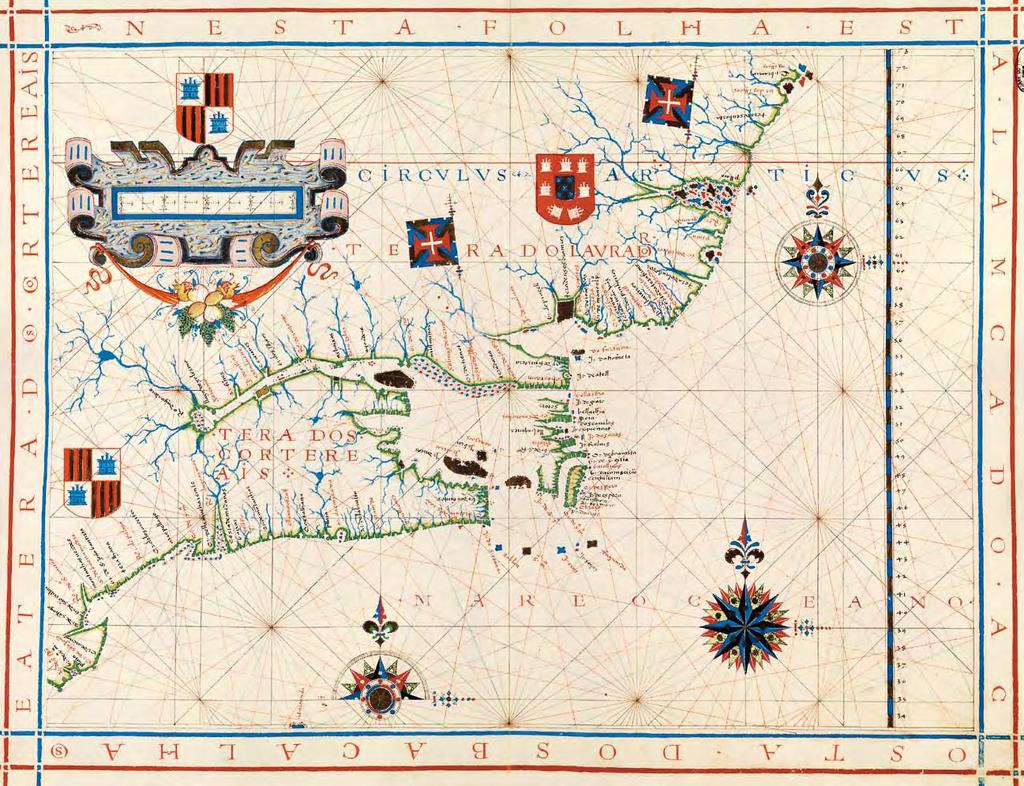
3 Canada

4 United Kingdom, Southern Europe and North of Africa

5 Strait of Magellan

6 West Indies, Central and South America, up to the Amazon River


 by Luís Filipe F. R.")
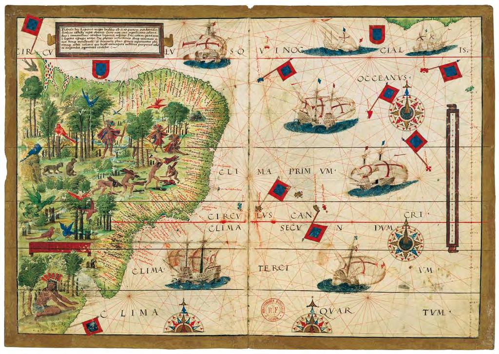
7 Vallard Atlas The Huntington Library, San Marino (us) Unique and unrepeatable first edition, strictly limited to 987 numbered and authenticated copies Probably made in Dieppe (France), this world atlas contains 15 nautical charts lavishly illustrated, as well as nautical information, tables of declinations, etc. The Vallard Atlas is one of the most noteworthy atlases of the sixteenth century, with formidable miniatures depicting the daily life of the native population at that period as well as being a wonderful testimony of the Age of Discovery, also proving that Australian territories had already been discovered by Portuguese adventurers in the sixteenth century. Shelf mark: HM 29 Date: Dieppe, ca Size: 390 x 280 mm 68 pages, 15 double-page nautical charts Red leather binding with gold decoration Full-colour commentary volume (240 p.) by Luís Filipe F. R. Thomaz (Director of the Institute for Oriental Studies of the Portuguese Catholic University), Dennis Reinhartz (Emeritus professor at the University of Texas in Arlington) y Carlos Miranda García-Tejedor (Doctor in History) moleiro.com/online Europe and northern Africa (South-Up map)

8 Southern Africa and Madagascar (South-Up map)

9 South America (South-Up map)

10 Northwest Africa (South-Up map)
")
11 Central America and the Antilles (South-Up map)


 and 2 maps (61 x 117 cm) Made by Pedro and Jorge Reinel, Lopo Homem (cartographers) and António de Holanda (miniaturist) Silk cases Full-colour commentary volume (432 pp.")
12 Atlas Miller Bibliothèque nationale de France, Paris Unique and unrepeatable first edition, strictly limited to 987 numbered and authenticated copies This gem in the history of cartography is the outcome of the combined efforts of the workshops of the first two schools of Portuguese cartography: the experienced Reinels school and the Homems school. The extraordinarily rich decoration of this atlas is undoubtedly the work of a first class illuminator: António de Holanda. The Atlas Miller is deservedly considered to be one of the best known and most valuable cartographic monuments of all times and its lavish artistic decoration is particularly noteworthy. Date: 1519 Size: 6 parchment leaves: 8 maps (41.5 x 59 cm) and 2 maps (61 x 117 cm) Made by Pedro and Jorge Reinel, Lopo Homem (cartographers) and António de Holanda (miniaturist) Silk cases Full-colour commentary volume (432 pp.) by Luís Filipe Thomaz (Director of the Institute for Oriental Studies of the Portuguese Catholic University), Alfredo Pinheiro Marques (Centro do Estudos do Mar Luís de Albuquerque) and Bernardo Sa Nogueira (Universidade de Lisboa) Tlf. UK +44 (0) / USA Madagascar
13 Brazil
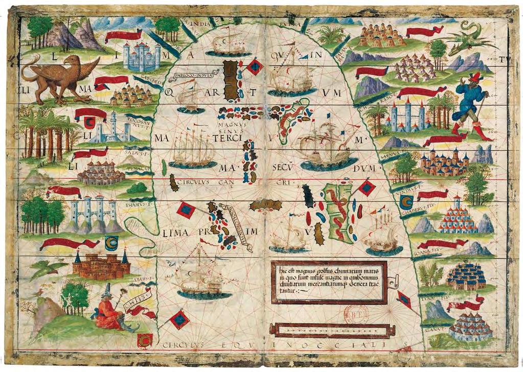
14 China Sea

15 Atlantic Ocean
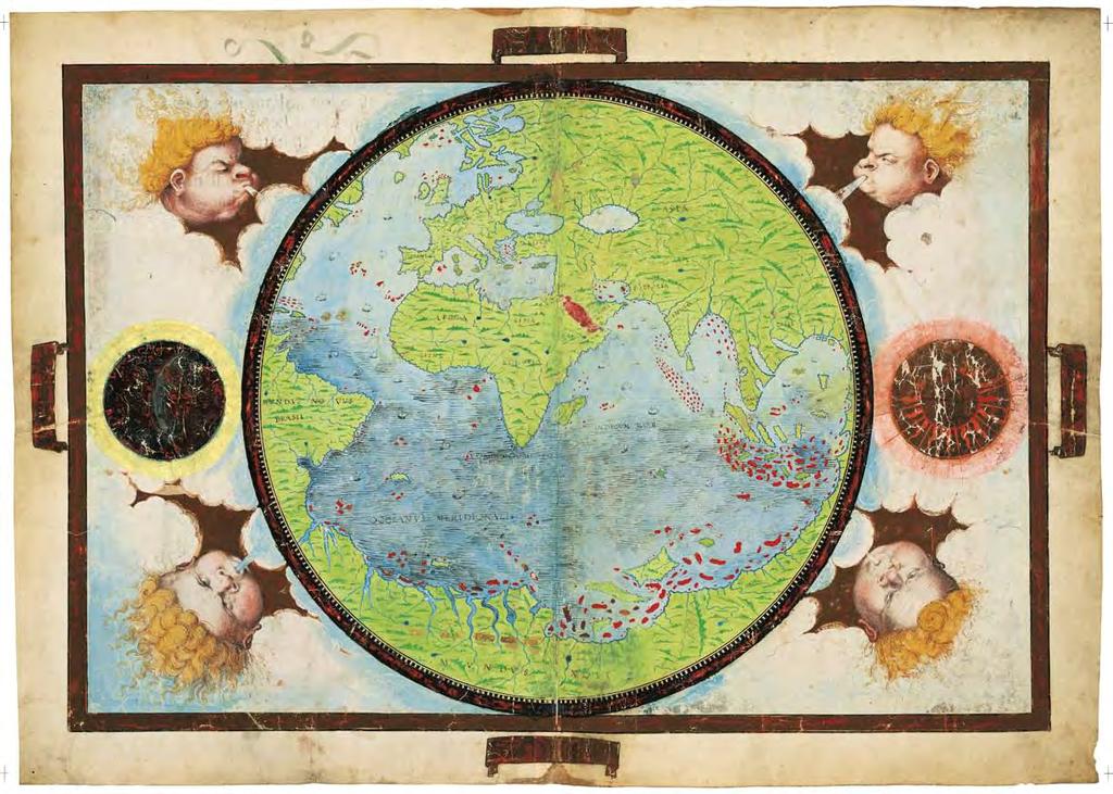
16 Planisphere
 20 7193 4986 - USA 1305 831 4986 - ES (+34) 932 402 091 www.moleiro.com - www.moleiro.com/online facebook.")
17 M. Moleiro N The Art of Perfection Travesera de Gracia, Barcelona - Spain Tel. UK +44 (0) USA ES (+34) facebook.com/moleiro - twitter.com/moleiroeditor youtube.com/moleiroeditor
Universale, Giacomo Cosmographo In Venetia MDXXXXVI
 Universale, Giacomo Cosmographo In Venetia MDXXXXVI The large oval world map of Giacomo Gastaldi, the most influential Venetian map publisher of the 16 th century, was first printed in 1546. It was the
The Christopher Columbus Chart #257
 TITLE: The Christopher Columbus Chart DATE: 1492-1500 AUTHOR: Christopher Columbus DESCRIPTION: In 1924, Charles de La Ronciere, the renowned French historian of exploration and cartography, attributed
GEOGRAPHY SOURCING PRACTICE
 What did people in the 1300s know about the size and location of important European countries and cities? This map was created using an earlier map that was part of a popular encyclopedia published between
Phase 1 Cards. Phase 1. Phase 1. How many picnic areas does the park have? Write the answer near the legend.
 S T U D E N T H A N D O U T F Cards Write the map s title in the northwest corner above the map. How many picnic areas does the park have? Write the answer near the legend. 1 2 Draw a compass rose near
Geocarta Nautica Universale #333.1
 Title: Geocarta Nautica Universale Date: 1523 Author: Giovanni [Juan] Vespucci Description: This large map is attributed to Giovanni [Juan] Vespucci, born in Florence in 1486, who was the nephew of the
Student Handout. Write the map s title in the northwest corner of the map. How many picnic areas does the park have? Write the answer near the legend.
 Student Handout 1F Cards Write the map s title in the northwest corner of the map. How many picnic areas does the park have? Write the answer near the legend. 1 2 Draw a compass rose near the west edge
Juan Rodríguez Cabrillo: The Geography of Exploration and Conquest
 lesson ThRee Juan Rodríguez Cabrillo: The Geography of Exploration and Conquest objectives: To place Cabrillo s life in the context of the Age of Exploration To understand geographical understanding of
5 th Grade Social Studies Goals for the First Trimester Miss Gaull
 5 th Grade Social Studies Goals for the First Trimester Overview: American People, American Land The American People Government by the People Free Enterprise Lands and Regions Resources and the Environment
09 November 2017 (Week ) NEW BRITISH ADMIRALTY PUBLICATIONS AVAILABLE NOW
 NEW BRITISH ADMIRALTY PUBLICATIONS AVAILABLE NOW") 09 November 2017 (Week 45 2017) NEW BRITISH ADMIRALTY PUBLICATIONS AVAILABLE NOW CODE TITLE AVAILABLE PRICE GBP NP057B Norway Pilot Volume 2B, 10th Edition, 2017 WK 45/17 60.60 NP207-18 ADMIRALTY Tide
09 November 2017 (Week 45 2017) NEW BRITISH ADMIRALTY PUBLICATIONS AVAILABLE NOW CODE TITLE AVAILABLE PRICE GBP NP057B Norway Pilot Volume 2B, 10th Edition, 2017 WK 45/17 60.60 NP207-18 ADMIRALTY Tide
GEOPOLITICS AFRICA - AMERICA BRAZIL DIASPORA. CENTURIES XV - XVI - XVII - XVIII XIX
 GEOPOLITICS AFRICA - AMERICA BRAZIL DIASPORA. CENTURIES XV - XVI - XVII - XVIII XIX CARTOGRAPHY FOR EDUCATION AFRO-BRAZILIAN EDUCATION AND MAPPING OF THE AFRICAN DIASPORA Establish and recognize other
Atlas Historical World Atlas By Rand Mcnally
 Atlas Historical World Atlas By Rand Mcnally If searched for a book by Rand Mcnally Atlas Historical World Atlas in pdf format, then you've come to faithful site. We present the complete option of this
Module 7: Plate Tectonics and Earth's Structure Topic 2 Content: Major Events in the History of Plate Tectonics Theory Notes
 Introduction Like most scientific theories, the Theory of Plate Tectonics did not come about overnight, or even over one decade. It was a discovery many centuries in the making. In this interactivity,
Smyth County Schools Curriculum Map. 1st 6 Weeks 2nd 6 Weeks 3rd 6 Weeks 3.5 a, b, & e, , 3.10 a,b, &c, 3.11, , 3.2, 3.4, 3.
 Standards Grade: 3rd Subject: 1st 6 Weeks 2nd 6 Weeks 3rd 6 Weeks 3.5 a, b, & e, 3.6 3.6, 3.10 a,b, &c, 3.11, 312 3.1, 3.2, 3.4, 3.6 all Content STANDARD 3.5 The student will develop map skills by a) positioning
An Overview on the Ancient Charts in China From the Fifteenth to the Eighteenth Century
 An Overview on the Ancient Charts in China From the Fifteenth to the Eighteenth Century Zhu Jianqiu, Li Hanrong and Zhujin Tianjin Institute of Hydrographic Surveying and Charting, P.R China Fax: (8622)
Limits in the Seas. No. 96 June 6, Greece Italy. Continental Shelf Boundary. (Country Codes: GR-IT)
") Limits in the Seas No. 96 June 6, 1982 Greece Italy Continental Shelf Boundary (Country Codes: GR-IT) The Geographer Office of the Geographer Bureau of Intelligence and Research INTERNATIONAL BOUNDARY
Limits in the Seas No. 96 June 6, 1982 Greece Italy Continental Shelf Boundary (Country Codes: GR-IT) The Geographer Office of the Geographer Bureau of Intelligence and Research INTERNATIONAL BOUNDARY
PORTUGAL NATIONAL REPORT
 PORTUGAL NATIONAL REPORT 13 TH SOUTHERN AFRICA AND ISLANDS HYDROGRAPHIC COMMISSION MEETING Cape Town, South Africa 29 th 31 st August 2016 INSTITUTO HIDROGRÁFICO Miguel Arenga IHPT Head of the Hydrography
Europe, Canada, Latin America, & Australia
 Europe, Canada, Latin America, & Australia EUROPE SS6G8 The student will locate selected features of Europe. a. Locate on a world and regional political- physical map: the Danube River, Rhine River, English
Year 34 B2 Geography - Continents and Oceans 2018 Key Skills to be covered: Taken from Level 3 Taken from Level 4
 Key Skills to be covered: Taken from Level 3 Taken from Level 4 Geographical Enquiry: I ask, Which PHYSICAL features does this place have? I ask, Which HUMAN features does this place have? I give reasons
PORTUGAL NATIONAL REPORT
 PORTUGAL NATIONAL REPORT 14 TH MEETING OF THE EASTERN ATLANTIC HYDROGRAPHIC COMMISSION Cadiz, Spain 18 th 20 th October 2016 INSTITUTO HIDROGRÁFICO Miguel Arenga IHPT Head of the Hydrography Division 2016-10-18
The Northwest Passage Grades 6-8
 The Northwest Passage Grades 6-8 Introduction European and North American governments and merchants expended a tremendous amount of effort during the 16 th through 19 th centuries in the quest to find
Map Skills Scavenger Hunt
 Map Skills Scavenger Hunt Introduction to: Continents Cardinal Directions Relative Location Equator and Prime Meridian Hemispheres Reading a Political Map Reading a Physical Map Idea: This product includes
Frederick de Wit s Atlas
 Fiona Melhuish name Special Collections Services Section Frederick de Wit s Atlas Special Collections featured item by Fiona Melhuish, UMASCS Librarian. [Atlas] [cartographic material] / [chiefly by Frederick
2011, 1998, 1987 Copyright by Remedia Publications, Inc. All Rights Reserved. Printed in the U.S.A.
 See the world REM 129A A Teaching Resource From 2011, 1998, 1987 Copyright by Remedia Publications, Inc. All Rights Reserved. Printed in the U.S.A. The purchase of this product entitles the individual
MAP SET. BrITAIN S & EXCERPTS. Norman B. Leventhal Map Center Digital Collections leventhalmap.org
 MAP SET BrITAIN S NORTH AMERICAN EMPIRE 1607 1764 Worksheets & EXCERPTS Norman B. Leventhal Map Center Digital Collections leventhalmap.org MAP 1 New england 1675 MAP Inquiry WORKSHEET Circle which of
Laurier Centre for Military Strategic and Disarmament Studies
 Laurier Centre for Military Strategic and Disarmament Studies Finding Aid - (MG-0036) Generated by Access to Memory (AtoM) 2.3.1 Printed: August 24, 2017 Language of description: English Laurier Centre
Exploring North America
 Exploring North America Continents of the World Geography Series Author: Michael Kramme, Ph.D. Consultants: Schyrlet Cameron and Carolyn Craig Editors: Mary Dieterich and Sarah M. Anderson COPYRIGHT 2012
Latitude & Longitude. Worksheets & activities to teach latitude & longitude. Includes notes, activities, review & all answer keys. 11 pages!
 Latitude & Longitude Worksheets & activities to teach latitude & longitude. Includes notes, activities, review & all answer keys. 11 pages! Lines of Latitude & Longitude Name: Lines of latitude and longitude
Exploring Europe. Continents of the World Geography Series
 Exploring Europe Continents of the World Geography Series Author: Michael Kramme, Ph.D. Consultants: Schyrlet Cameron and Carolyn Craig Editors: Mary Dieterich and Sarah M. Anderson COPYRIGHT 2012 Mark
Edgebrook Geography Bee Workshop
 Edgebrook Geography Bee Workshop January 12, 2015 1/13/2015 1 Image from https://www.google.com/search?q=world+map 1/13/2015 2 Two Bees Grade 4-8: National Geographic Society (NGS) Geography Bee School
The Americas Political Map Ng Country Region Maps
 We have made it easy for you to find a PDF Ebooks without any digging. And by having access to our ebooks online or by storing it on your computer, you have convenient answers with the americas political
Map Skills Unit. Note taking unit
 Map Skills Unit Note taking unit Introduction To learn about the Earth, we are going to learn about two geographic tools you can use.globes and maps. Globe A globe is a round model of the planet Earth
State Practice on the Establishment of Multiple Maritime Boundaries: Assessing the Challenges of Separating Seabed and Water Column Boundaries
 State Practice on the Establishment of Multiple Maritime Boundaries: Assessing the Challenges of Separating Seabed and Water Column Boundaries Professor Clive Schofield The Australian National Centre for
Your web browser (Safari 7) is out of date. For more security, comfort and the best experience on this site: Update your browser Ignore
 is out of date. For more security, comfort and the best experience on this site: Update your browser Ignore") Your web browser (Safari 7) is out of date. For more security, comfort and the best experience on this site: Update your browser Ignore Activitydevelop RESEARCH EXAMPL ES O F PHYSICAL GEO GRAPHY How do
Your web browser (Safari 7) is out of date. For more security, comfort and the best experience on this site: Update your browser Ignore Activitydevelop RESEARCH EXAMPL ES O F PHYSICAL GEO GRAPHY How do
Understanding Projections
 GEOGRAPHY SKILLS 1 Understanding Projections The earth is a sphere and is best shown as a globe. For books and posters, though, the earth has to be represented as a flat object. To do this, mapmakers create
What is GIS? A very brief description for the newly curious
 What is GIS? A very brief description for the newly curious Diana Stuart Sinton and Jennifer J. Lund Geographic information systems (GIS) combine maps with tables of information. The information words,
South America: A Map Mystery Completed By:
 South America: A Map Mystery Completed By: Historians who study old maps have to be detectives. Even though the people of the past can t directly tell us what they thought or believed, they left clues
On the Generalkarte coverage of the northern part of Greece and its interactions with the relevant subsequent Greek map series
 Alexandra Koussoulakou, Angeliki Tsorlini **, Chryssoula Boutoura *** On the Generalkarte coverage of the northern part of Greece and its interactions with the relevant subsequent Greek map series Keywords:
Name Date Period Barron s (6 th edition) Chapter 7 Urban Geography
 Chapter 7 Urban Geography") Name Date Period Barron s (6 th edition) Chapter 7 Urban Geography Historical Geography of Urban Environments 1. In what way did the development of different types of occupations (carpenters, merchants,
Name Date Period Barron s (6 th edition) Chapter 7 Urban Geography Historical Geography of Urban Environments 1. In what way did the development of different types of occupations (carpenters, merchants,
Geography Long Term Plan. Autumn Spring Summer
 Geography Long Term Plan Autumn Spring Summer Year 1 Working Scientifically covered throughout the year Location Geography of UK Name, locate and identify characteristics of the four countries and capital
Map Skills Test. 1. What do we call a person who makes maps? a. mapographer b. cartographer c. geologist d. archaeologist
 Map Skills Test 1. What do we call a person who makes maps? a. mapographer b. cartographer c. geologist d. archaeologist 2. What is the name of the 0 latitude line? a. Equator b. Arctic Circle c. First
Many Ways to Name a Place
 Your web browser (Safari 7) is out of date. For more security, comfort and Activityapply the best experience on this site: Update your browser Ignore Many Ways to Name a Place What are the names for the
Michelin Berlin City Map - Laminated (Michelin Map) By Michelin READ ONLINE
 By Michelin READ ONLINE") Michelin Berlin City Map - Laminated (Michelin Map) By Michelin READ ONLINE If searched for a book by Michelin Michelin Berlin City Map - Laminated (Michelin Map) in pdf format, then you have come on to
Michelin Berlin City Map - Laminated (Michelin Map) By Michelin READ ONLINE If searched for a book by Michelin Michelin Berlin City Map - Laminated (Michelin Map) in pdf format, then you have come on to
THE EARTH AND ITS REPRESENTATION
 UNIT 7 THE EARTH AND ITS REPRESENTATION TABLE OF CONTENTS 1 THE EARTH AND THE SOLAR SYSTEM... 2 2 THE EARTH S MOVEMENTS... 2 2.1 Rotation.... 2 2.2 The revolution of the Earth: seasons of the year....
The Ancient Map Code
 CHAPTER BY CHAPTER SYNOPSIS The Ancient Map Code Mystery of Chinese Global Exploration before Columbus September 20 th, 2009 Liu Gang Room 606, 6F NCI Tower, A12 Jianguomenwai Avenue, Chaoyang District,
[05/18] Admiralty Charts affected by the Publication List
![[05/18] Admiralty Charts affected by the Publication List](/thumbs/76/73897105.jpg "[05/18] Admiralty Charts affected by the Publication List") Admiralty Charts affected by the Publication List [05/18] ADMIRALTY Charts International Charts 105 INT 636 108 INT 1040 129 INT 1041 134 INT 1400 701 INT 1401 804 INT 1402 1405 INT 1403 1427 INT 1404
Admiralty Charts affected by the Publication List [05/18] ADMIRALTY Charts International Charts 105 INT 636 108 INT 1040 129 INT 1041 134 INT 1400 701 INT 1401 804 INT 1402 1405 INT 1403 1427 INT 1404
TECHNICAL DOCUMENT R 2 OF THE SPANISH BRAILLE COMMISSION GENERAL CRITERIA FOR PREPARING ADAPTED MAPS FOR VISUALLY IMPAIRED PERSONS
 TECHNICAL DOCUMENT R 2 OF THE SPANISH BRAILLE COMMISSION GENERAL CRITERIA FOR PREPARING ADAPTED MAPS FOR VISUALLY IMPAIRED PERSONS Updated on December 2013 (Version 1) First edition in English, March 2015
Year 1 name and locate the four countries and capital cities of the United Kingdom and its surrounding seas
 Long Term Objective Organisation for Geography Please note that only statutory requirements should be included in this document; any supplementary guidance and information should be retained by Subject
Cranford Park CE Primary School. Subject Overview for Geography. Autumn 1 Autumn 2 Spring 1 Spring 2 Summer 1 Summer 2 Title of unit.
 Autumn 1 Autumn 2 Spring 1 Spring 2 Summer 1 Summer 2 Main Objectives /Skills Main Objectives /Skills Main Objectives /Skills Main Objectives /Skills Main Objectives /Skills Main Objectives /Skills Foundation
Sample file. Copyright 2002, 2003, 2005, 2006, 2009 Cindy Wiggers Revised 2006 Published by Geography Matters, Inc
 Copyright 2002, 2003, 2005, 2006, 2009 Cindy Wiggers Revised 2006 Published by Geography Matters, Inc Cover design by Alex Wiggers Photography by Kim Whitmore-Weber All rights reserved. No part of this
1. Match the words in the first column to the meaning in the second column. [5]
![1. Match the words in the first column to the meaning in the second column. [5]](/thumbs/96/126839765.jpg "1. Match the words in the first column to the meaning in the second column. [5]") Exercise 1: [40 POINTS] 1. Match the words in the first column to the meaning in the second column. [5] Equator Around earth between the Equator and the Poles. Greenwich meridian Half of earth. Longitude
Exercise 1: [40 POINTS] 1. Match the words in the first column to the meaning in the second column. [5] Equator Around earth between the Equator and the Poles. Greenwich meridian Half of earth. Longitude
Lesson Topic: Maps of New England
 1 Lesson Topic: Maps of New England Essential Question: How and why have maps of New England changed over time? Grade: 3 Standard/s: Common Core State Standards CCSS.ELA-LITERACY.RI.3.9 Compare and contrast
2008 SIVECO Romania. All Rights Reserved. Geography. AeL econtent Catalogue
 2008 SIVECO Romania. All Rights Reserved. Geography AeL econtent Catalogue The Earth's Movements Recommended for two hours of teaching. AeL Code: 352. 2. The Earth Rotation Movement in 24 hours 3. The
Unit 2 Study Guide: The World in Spatial Terms
 Name Date Hour Unit 2 Study Guide: The World in Spatial Terms TEST is WEDNESDAY, DECEMBER 19 TH This study guide contains all the concepts that will be on your test. Vocabulary words and concepts will
This image cannot currently be displayed. Course Catalog. History and Geography Glynlyon, Inc.
 This image cannot currently be displayed. Course Catalog History and Geography 2016 Glynlyon, Inc. History and Geography Table of Contents COURSE OVERVIEW... 1 UNIT 1: OUR EARTH... 1 UNIT 2: SEAPORT CITIES...
New World Propaganda: Pigafetta's Journal, World Maps, and New European Ideologies,
 Bowling Green State University ScholarWorks@BGSU HIST 4800 Early America in the Atlantic World (Herndon) HIST 4800 Spring 5-5-2014 New World Propaganda: Pigafetta's Journal, World Maps, and New European
The Renaissance sets the stage for sustained ocean exploration
 Olli Ocean Exploration The Renaissance sets the stage for sustained ocean exploration Marvin Falk The sustained exploration of the earth s ocean required a system for preservation, accumulation, and dissemination
El Niño / Southern Oscillation
 El Niño / Southern Oscillation Student Packet 2 Use contents of this packet as you feel appropriate. You are free to copy and use any of the material in this lesson plan. Packet Contents Introduction on
[50/16] WMO SURVEY. Admiralty Charts affected by the Publication List
![[50/16] WMO SURVEY. Admiralty Charts affected by the Publication List](/thumbs/91/106481495.jpg "[50/16] WMO SURVEY. Admiralty Charts affected by the Publication List") Admiralty Charts affected by the Publication List [50/16] Admiralty Chart Admiralty Chart 410 AUS 58 536 AUS 60 1444 AUS 510 1534 AUS 621 1535 INT 1160 2014 INT 1201 2015 INT 1202 2018 INT 1218 2040 INT
Admiralty Charts affected by the Publication List [50/16] Admiralty Chart Admiralty Chart 410 AUS 58 536 AUS 60 1444 AUS 510 1534 AUS 621 1535 INT 1160 2014 INT 1201 2015 INT 1202 2018 INT 1218 2040 INT
 Page 1 of 5 Home research global climate enso effects Research Effects of El Niño on world weather Precipitation Temperature Tropical Cyclones El Niño affects the weather in large parts of the world. The
CHAPTER 1. Geo Challenges 1A to 1D. & World Map Activity
 CHAPTER 1 Geo Challenges 1A to 1D & World Map Activity SELECT YOUR CHALLENGE World Map Activity Challenge 1A Challenge 1B Challenge 1C Challenge 1D Challenge 1A WS PG. 2 STEP #1 Label the largest continent
SMART NOTES ON INDIAN GEOGRAPHY - 1
 ON INDIAN GEOGRAPHY - 1 Point. Precise. Powerful. www.thesmartnotes.org ON INDIAN GEOGRAPHY - 1 To our Hardworking and persistence aspirants. Success is going from failure to failure without losing enthusiasm.
Learning Target : Describe the purposes and uses of different types of maps.
 Learning Target : Describe the purposes and uses of different types of maps. Directions: 1. Below, place a where you think you are located. 2. In which continent are you located? 3. In which country are
Iceland. 1. Warm up. A. Talk about the picture and read the essay. B. Discuss the questions about the essay.
 1. Warm up A. Talk about the picture and read the essay. Iceland My country, Iceland, is one of the most beautiful countries on Earth. It is an island country. It is located in Europe, in the North Atlantic
Barry Lawrence Ruderman Antique Maps Inc.
 Stock#: 46848 Map Maker: Blaeu / Goos / Loots Date: Place: Color: Condition: Size: 1695 circa Amsterdam Hand Colored VG 39 x 32 inches Price: $235,000.00 Description: "A scientific and artistic document
Updating the GEBCO Grid
 Updating the GEBCO Grid PAULINE WEATHERALL, GEBCO DIGITAL ATLAS MANAGER, BRITISH OCEANOGRAPHIC DATA CENTRE (BODC), NATIONAL OCEANOGRAPHY CENTRE (NOC), LIVERPOOL, UK. GEBCO TSCOM and SCRUM meeting, Kuala
Cartography and Children Commission: Proposals for the next 4 years
 International Cartographic Association Cartography and Children Commission: Proposals for the next 4 years José Jesús Reyes Nuñez Eötvös Loránd University Dept. of Cartography and Geoinformatics Budapest,
American Map 2007 Road Atlas: United States - Canada - Mexico By American Map Corporation
 American Map 2007 Road Atlas: United States - Canada - Mexico By American Map Corporation If you are searching for the book American Map 2007 Road Atlas: United States - Canada - Mexico by American Map
Physical Geography. Ariel view of the Amazon Rainforest. A Look at the Seven Continents
 Physical Geography In this unit you will learn about general physical geography. The study of the Earth s surface features provides the setting for the human-environmental interactions and for the human
Nomination form International Memory of the World Register. Turkey-The Piri Reis World Map (1513) in the Topkapı Palace Museum Library
 in the Topkapı Palace Museum Library") Nomination form International Memory of the World Register Turkey-The Piri Reis World Map (1513) in the Topkapı Palace Museum Library ID Code [2016-34] 1.0 Summary (max 200 words) The Piri Reis World Map
Nomination form International Memory of the World Register Turkey-The Piri Reis World Map (1513) in the Topkapı Palace Museum Library ID Code [2016-34] 1.0 Summary (max 200 words) The Piri Reis World Map
Geography Long Term Plan 2018
 Geography Long Term Plan 2018 Geography Co-ordinator: Megan Frost A high-quality geography education should inspire in pupils a curiosity and fascination about the world and its people that will remain
Beginning Orienteering Post visit
 Beginning Orienteering Post visit Classroom Activities Brief Synopsis The post activities are designed to reinforce what the students learned at Eagle Bluff and practice the skill of map reading. Students
Scheme for Learning. Curriculum Area Geography. Assessment Cycle Two Where in the world? Continent Ocean Human Physical Geography
 Personnel Responsible CMS Scheme for Learning Curriculum Area Geography Assessment Cycle Two Where in the world? Quality Assured by PLE Exam Board/Qualification Linked to OCR B Geography Assessment Cycle
REGIONAL PARTICULARITIES OF THE METONIC METEOROLOGICAL CYCLE ON EARTH
 DOI 10.1515/pesd-2016-0030 PESD, VOL. 10, no. 2, 2016 REGIONAL PARTICULARITIES OF THE METONIC METEOROLOGICAL CYCLE ON EARTH Ion Isaia 1 Key words: Metonic astronomical cycle, multiples of the Metonic cycle,
Globes, Maps, and Atlases. Plus, A Whole Bunch of Other Way Cool Geographic Information!!!
 Globes, Maps, and Atlases Plus, A Whole Bunch of Other Way Cool Geographic Information!!! Globes Are the Most Accurate Portrayal of the Earth The earth is about 24,900 miles in circumference, and about
Prentice Hall. World Explorer: People, Places, Cultures Grade 7. Oklahoma Priority Academic Student Skills (PASS) for Grade 7 World Geography
 for Grade 7 World Geography") Prentice Hall World Explorer: People, Places, Cultures 2007 Grade 7 C O R R E L A T E D T O for Grade 7 1. Locate, gather, analyze, and apply information from primary and secondary sources. WORLD GEOGRAPHY
Prentice Hall World Explorer: People, Places, Cultures 2007 Grade 7 C O R R E L A T E D T O for Grade 7 1. Locate, gather, analyze, and apply information from primary and secondary sources. WORLD GEOGRAPHY
Unit 1 Test - Version A
 Unit 1 Test - Version A 1. Approximately, how many degrees of longitude equal one time zone change? a. 5 b. 10 c. 15 d. 20 e. 25 2. The city of Lewisville has a population of 1,000 people living in 100
Weekly Weather Flash. August 21 September 3. Europe
 Weekly Weather Flash August 21 September 3 US THIS WEEK: Cool in the West; Warm in the East and Pacific Northwest; Showers from the Plains to the East Coast A LOOK AHEAD: US Falls into Fall; Interior Cooler
1 st Six Weeks # of Days. Unit # and Title Unit 1 Geography Overview
 1 st Six Weeks # of Days Unit # and Title Unit 1 Geography Overview Orange Grove ISD Instructional Planning Information and Process Standards The Process Standards Must Be Included in Each Unit # of Class
Essential Questions What are the major physical components of the world, and how are they represented on a map? 3.4
 Third Grade Social Studies Unit One Six Weeks GEOGRAPHY Originally compiled by Russellville In order for students to understand that geography influences the development of a region as well as the interactions
Pool Canvas. Add. Creation Settings. Chapter 1--Objectives and Tools of World Regional Geography. Description Instructions.
 1 of 6 TEST BANK > CONTROL PANEL > POOL MANAGER > POOL CANVAS Pool Canvas Add, modify, and remove questions. Select a question type from the Add Question drop-down list and click Go to add questions. Use
Pedro Nunes and the Retrogression of the Sun
 Irish Math. oc. Bulletin Number 81, ummer 2018, 23 30 IN 0791-5578 Pedro Nunes and the Retrogression of the un PETER LYNCH What has been will be again, what has been done will be done again; there is nothing
2012. Proceedings of the 11 European Geoparks Conference. AGA Associação Geoparque Arouca, Arouca, 5-6.
 References to this volume It is suggested that either the following alternatives should be used for future bibliographic references to the whole or part this volume: th Sá, A.A., Rocha, D., Paz, A. & Correia,
The Brixen Globes #333.2
 Title: The Brixen Globes [formerly known as the Mounted Hauslab Globe] Author: unknown Date: 1522 Description: One of two hand-painted globes one terrestrial, the other celestial-- known collectively as
Social Studies Tools (Maps & Sources) Test Study Guide
 Test Study Guide") Social Studies Tools (Maps & Sources) Test Study Guide Name: ANSWER KEY Date: Period: Directions: Complete this study guide as a way to prepare for your test on our Social Studies Tools unit about maps
Social Studies Tools (Maps & Sources) Test Study Guide Name: ANSWER KEY Date: Period: Directions: Complete this study guide as a way to prepare for your test on our Social Studies Tools unit about maps
New National Curriculum Geography Skills Planning KS1
 New National Curriculum Geography Skills Planning KS1 Enquiry Question Objective-essential knowledge skills or understanding Locational Knowledge Standards /Success Criteria Lesson progression over half
UNI DOCTORAL PROGRAM: URBAN AND ARCHITECTONIC MANAGEMENT AND VALUATIONS
 UNI UNIVERSITAT POLITÈCNICA DE CATALUNYA - BARCELONATECH ESCOLA TÈCNICA SUPERIOR D'ARQUITECTURA DE BARCELONA DEPARTAMENT DE CONSTRUCCIONS ARQUITECTÒNIQUES I DOCTORAL PROGRAM: URBAN AND ARCHITECTONIC MANAGEMENT
St John s Catholic Primary School. Geography Policy. Mission Statement
 St John s Catholic Primary School Geography Policy Mission Statement We at St John s strive for excellence in education by providing a safe, secure and caring family environment where individuals are valued
History of Cartography
 History of Cartography World s oldest map Babylonia, 6 th century BC http://math.rice.edu/~lanius/pres/map/maphis.html https://www.gislounge.com/mapping-through-the-ages/ Projections: https://www.jasondavies.com/maps/transition
Long Term and Medium-Term Planning Geography Focus With Art and DT As Secondary Subjects
 Long Term and Medium-Term Planning Geography Focus With Art and DT As Secondary Subjects Term and Year: Autumn Term 1 2018 Topic: Around the World Teacher: Miss Wiseman Key question(s): What can I see
Continents. and. Oceans
 Continents and Oceans Continents and Oceans Africa Africa Antarctica Antarctica Asia Asia Australia Australia Europe Europe North America North America South America South America World Map World Map Continents
Progress on digitising Portuguese and Chilean surface data plus Spanish pilot balloon data
 Progress on digitising Portuguese and Chilean surface data plus Spanish pilot balloon data Maria Antónia Valente, Maria Clara Ventura, Pedro Gomes, Maria Helena Cordeiro, Maria João Rocha, Sérgio João,
Canadian Mapping Big Book
 Canadian Mapping Big Book Grades 4-6 Written by Lynda Golletz Illustrated by S&S Learning Materials About the Author: Lynda Golletz was an elementary school teacher for thirty-three years. She is the author
Map Making. Chapter 2 Section 1
 Map Making Chapter 2 Section 1 Latitude and Longitude Objectives Compare and contrast latitude and longitude. Describe how time zones vary. Vocabulary cartography equator latitude longitude prime meridian
Globe and Gores by Demongenet
 Globe and Gores by Demongenet Cartographer: Franciscus Demongenet Date: 1552-1560 Size: 3.5 inches Probably made in Southern Germany, circa 1560-1580. The 3.5 inch globe comprised of two gilt brass hemispheres
Introduction to Cartography GEOG 2016 E. Lecture-2 Geodesy and Projections
 Introduction to Cartography GEOG 2016 E Lecture-2 Geodesy and Projections What is Geodesy? The science of geodesy determines: Earth s shape and Interrelation of different points on earth s surface The
If searching for a ebook A cartografia portuguesa do Japao: Seculos XVI-XVII : catalogo das cartas portuguesas = The Portuguese cartography of Japan
 A Cartografia Portuguesa Do Japao: Seculos XVI-XVII : Catalogo Das Cartas Portuguesas = The Portuguese Cartography Of Japan : XVI-XVII Centuries :... Of Portuguese Charts (Portuguese Edition) By Alfredo
Geography Route Planner
 Geography Route Planner Introduction to Route Planners Route Planners outline the Key Stages 1-3 curriculum to be taught within each campus of the Bury St Edmunds Trust. Each Route Planner has been designed
Mexico (National Geographic Adventure Map) By National Geographic Maps - Adventure
 By National Geographic Maps - Adventure") Mexico (National Geographic Adventure Map) By National Geographic Maps - Adventure If you are searching for the book Mexico (National Geographic Adventure Map) by National Geographic Maps - Adventure in
Mexico (National Geographic Adventure Map) By National Geographic Maps - Adventure If you are searching for the book Mexico (National Geographic Adventure Map) by National Geographic Maps - Adventure in
The Age of Exploration & First Contact. Unit 9
 The Age of Exploration & First Contact Unit 9 Unit 9 Table of Contents The Age of Exploration and First Contact 190. Unit 9 Table of Contents 191. Cover Page Unit 9 (use Chapter 12) Bellwork Set up and
Future population exposure to US heat extremes
 Outline SUPPLEMENTARY INFORMATION DOI: 10.1038/NCLIMATE2631 Future population exposure to US heat extremes Jones, O Neill, McDaniel, McGinnis, Mearns & Tebaldi This Supplementary Information contains additional