Continents. and. Oceans
|
|
|
- Wesley Wright
- 6 years ago
- Views:
Transcription

1 Continents and Oceans
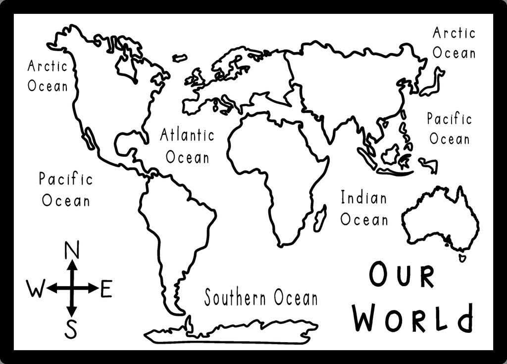

2 Continents and Oceans
3 Africa Africa Antarctica Antarctica
4 Asia Asia Australia Australia
5 Europe Europe North America North America
6 South America South America World Map World Map
7 Continents and Oceans Continents and Oceans
8 Africa Africa Antarctica Antarctica
9 Asia Asia Australia Australia
10 Europe Europe North America North America
11 South America South America World Map World Map
12 Continents and Oceans Continents and Oceans
13 US Spellings
14 Name the Continents Word Bank Australia Europe Africa Antarctica North America South America Asia
15 Color the Continents Color Australia blue. Color North America green. Color South America purple. Color Africa yellow. Color Asia red. Color Europe pink. Color Antarctica light blue.
16 Name the Oceans Word Bank Arctic Pacific Indian Atlantic Southern
17 Color the Oceans Color the Artic Ocean pink. Color the Pacific Ocean green. Color the Indian Ocean yellow. Color the Atlantic Ocean red. Color the Southern Ocean purple.
18 Continents and Oceans How many continents are there? How many oceans are there? Which continent is the biggest? Which continent is the smallest? Which continent do you live on? What is the closest ocean to you? 7
19 Atlantic Ocean Color the Atlantic Ocean blue. This is the largest ocean. The separates the North Atlantic from the South Atlantic. It was the first ocean to be crossed by. ship second equator
20 Pacific Ocean Color the Pacific Ocean blue. This is the ocean. It is than all the continents put together. It is also the ocean. The Great Barrier Reef, off the coast of is in the Pacific Ocean as are the islands of. Australia deepest bigger Hawaii largest
21 Southern Ocean Color the Southern Ocean blue. It is very in the Southern Ocean as it goes around. In Winter, more than of this Ocean is covered in ice and icebergs. It used to be called the Ocean. Antarctica half Antarctic cold
22 Arctic Ocean Color the Arctic Ocean blue. This Ocean is located by the Pole. It is the Ocean. Polar bears and live and swim in this Ocean. In Winter almost all of this Ocean is covered in ice and. smallest icebergs walruses North
23 Indian Ocean Color the Indian Ocean blue. This is the largest Ocean. It is also the Ocean being located by the. This Ocean has land on sides. It is located between Africa and. equator Australia third three warmest
24 Asia Color Asia red. Asia is the continent. It is also the most. Asia covers of the Earth s land. It is bound by the Ocean on the east, the Indian Ocean on the and the Ocean on the north. Pacific largest populous Arctic 30%
25 Europe Color Europe Pink Europe is the second continent by surface area. It is connected to to make the world s largest landmass, Eurasia. These 2 continents are divided by the mountains. Europe is the most populous continent. Asia smallest Ural third
26 Africa Color Africa yellow Africa is the second continent and the second most populated. It is surrounded by the Mediterranean to the north, the Ocean to the southeast, the Atlantic to the west and the Suez Canal and Red Sea in the northwest. Africa is located on the. equator Sea largest Indian Ocean
27 Australia Color Australia blue. Australia is the and lowest-lying human inhabited continent. It is also referred to as an island continent as it is surrounded by. This continent lies entirely south of the. Two-thirds of Australia is flat. smallest equator oceans desert
28 North America Color North America green. North America is the largest continent. It is bordered to the north by the Ocean the east by the Atlantic Ocean, to the west and south by the Pacific and to the southeast by the South America and the Caribbean. Arctic third Ocean Seas
29 South America Color South America purple. South America is the largest continent. It includes independent countries and is home to the world s highest. It is bordered by the Pacific Ocean to the west and the Ocean to the north and east. fourth waterfall 12 Atlantic
30 Antarctica Color Antarctica light blue. Antarctica is the third continent. It is the, driest and windiest continent. It is considered a as it receives only about 8 inches of rainfall a year. coldest desert smallest
31 Continent and Ocean Word Search N Q E R J A S S V G E S V O X A W C O B X N A P L A R N O I U L B A U M P T C T B R T W A I S A A L G A H F H D H D A I C A C R C A A C S N E L I N I C Z R M V E I Z A F T T T X C E E U P K R I I C I S V R N R G J T C C R C E V I Z O I W S F O A A S L C B P Z C U T S C F K U A C E V D A S O U T H E R N B E A F Australia Antarctica Europe Asia Southern Indian Pacific Arctic Atlantic Africa North America South America
32 UK / Australia Spellings
33 Name the Continents Word Bank Australia Europe Africa Antarctica North America South America Asia
34 Colour the Continents Colour Australia blue. Colour North America green. Colour South America purple. Colour Africa yellow. Colour Asia red. Colour Europe pink. Colour Antarctica light blue.
35 Name the Oceans Word Bank Arctic Pacific Indian Atlantic Southern
36 Colour the Oceans Colour the Artic Ocean pink. Colour the Pacific Ocean green. Colour the Indian Ocean yellow. Colour the Atlantic Ocean red. Colour the Southern Ocean purple.
37 Continents and Oceans How many continents are there? How many oceans are there? Which continent is the biggest? Which continent is the smallest? Which continent do you live on? What is the closest ocean to you? 7
38 Atlantic Ocean Colour the Atlantic Ocean blue. This is the largest ocean. The separates the North Atlantic from the South Atlantic. It was the first ocean to be crossed by. ship second equator
39 Pacific Ocean Colour the Pacific Ocean blue. This is the ocean. It is than all the continents put together. It is also the ocean. The Great Barrier Reef, off the coast of is in the Pacific Ocean as are the islands of. Australia deepest bigger Hawaii largest
40 Southern Ocean Colour the Southern Ocean blue. It is very in the Southern Ocean as it goes around. In Winter, more than of this Ocean is covered in ice and icebergs. It used to be called the Ocean. Antarctica half Antarctic cold
41 Arctic Ocean Colour the Arctic Ocean blue. This Ocean is located by the Pole. It is the Ocean. Polar bears and live and swim in this Ocean. In Winter almost all of this Ocean is covered in ice and. smallest icebergs walruses North
42 Indian Ocean Colour the Indian Ocean blue. This is the largest Ocean. It is also the Ocean being located by the. This Ocean has land on sides. It is located between Africa and. equator Australia third three warmest
43 Asia Colour Asia red. Asia is the continent. It is also the most. Asia covers of the Earth s land. It is bound by the Ocean on the east, the Indian Ocean on the and the Ocean on the north. Pacific largest populous Arctic 30%
44 Europe Colour Europe Pink Europe is the second continent by surface area. It is connected to to make the world s largest landmass, Eurasia. These 2 continents are divided by the mountains. Europe is the most populous continent. Asia smallest Ural third
45 Africa Colour Africa yellow Africa is the second continent and the second most populated. It is surrounded by the Mediterranean to the north, the Ocean to the southeast, the Atlantic to the west and the Suez Canal and Red Sea in the northwest. Africa is located on the. equator Sea largest Indian Ocean
46 Australia Colour Australia blue. Australia is the and lowest-lying human inhabited continent. It is also referred to as an island continent as it is surrounded by. This continent lies entirely south of the. Two-thirds of Australia is flat. smallest equator oceans desert
47 North America Colour North America green. North America is the largest continent. It is bordered to the north by the Ocean the east by the Atlantic Ocean, to the west and south by the Pacific and to the southeast by the South America and the Caribbean. Arctic third Ocean Seas
48 South America Colour South America purple. South America is the largest continent. It includes independent countries and is home to the world s highest. It is bordered by the Pacific Ocean to the west and the Ocean to the north and east. fourth waterfall 12 Atlantic
49 Antarctica Colour Antarctica light blue. Antarctica is the third continent. It is the, driest and windiest continent. It is considered a as it receives only about 8 inches of rainfall a year. coldest desert smallest
50 Continent and Ocean Word Search N Q E R J A S S V G E S V O X A W C O B X N A P L A R N O I U L B A U M P T C T B R T W A I S A A L G A H F H D H D A I C A C R C A A C S N E L I N I C Z R M V E I Z A F T T T X C E E U P K R I I C I S V R N R G J T C C R C E V I Z O I W S F O A A S L C B P Z C U T S C F K U A C E V D A S O U T H E R N B E A F Australia Antarctica Europe Asia Southern Indian Pacific Arctic Atlantic Africa North America South America
51 Thank you so very much for your interest in my products. Hope you see you soon at A Moment In Our World or at Twitter or at my Facebook Page - A Moment In Our World Terms of Use All printables are to be used for personal use only. Please DO: Download and print off for personal use Direct people to my BLOG and/or FACEBOOK PAGE Give the credit back to A MOMENT IN OUR WORLD when you blog about the files Please DO NOT: Link directly to the pdf file Alter the files in any way Store them on your website in any way Sell them in any form, on your site or print off and sell them Seek to use them to drive traffic to your site Thank you for your HONESTY. I reserve the right to change this policy at any time. If you have any questions please contact me: amomentinourworld@hotmail.com Fonts by: h7p:// Graphics from: 2 Super Teachers NOTICE: "By purchasing the file(s), you agree to the TERMS OF USE." & "These are copyrighted graphics, you may not resell / redistribute / recreate / use in your commercial projects or share these graphics in whole or in part for any reasons."
L is for Light! John 8:12
 L is for Light! John 8:12 Again Jesus spoke to them, saying, I am the light of the world. Whoever follows me will not walk in darkness, but will have the light of life. John 8:12 John 8:12 JESUS WORLD
Map Skills Scavenger Hunt
 Map Skills Scavenger Hunt Introduction to: Continents Cardinal Directions Relative Location Equator and Prime Meridian Hemispheres Reading a Political Map Reading a Physical Map Idea: This product includes
Visit us at...
 Thanks for your purchase. We hope you are pleased. We think you might like the website that we are working on. You will find websites that go along with your unit and word wall cards. We hope you enjoy.
Map Elements & The 5 Oceans
 Map Elements & The 5 Oceans Latitude and Longitude Longitude lines run north and south. Latitude lines run east and west. The lines measure distances in degrees. Latitude Longitude Where is 0 degrees?
On Earth, the land is broken into large pieces. These pieces are separated by large bodies of water called oceans. We call some of these pieces of
 The 7 Continents On Earth, the land is broken into large pieces. These pieces are separated by large bodies of water called oceans. We call some of these pieces of land continents. A continent is an area
GEOGRAPHY. Map Skills. Mrs. Pere ~ 2013
 GEOGRAPHY Map Skills Mrs. Pere ~ 2013 WHAT IS A GLOBE? A globe is a model of the Earth. North Pole Equator South Pole WHAT IS A MAP? A map is a flat drawing of a place. THE IMPORTANT PARTS OF A MAP 1.
Physical Geography. Ariel view of the Amazon Rainforest. A Look at the Seven Continents
 Physical Geography In this unit you will learn about general physical geography. The study of the Earth s surface features provides the setting for the human-environmental interactions and for the human
United States of America Geography
 United States of America Geography Part I by Sonja E. Schild LearnSmart Publishing Co. Vancouver, BC, Canada Phone: (604) 433-1347 ISBN 0-9694445-3-9 Notice! All rights reserved. Permission to reproduce
Map Skills Test. 1. What do we call a person who makes maps? a. mapographer b. cartographer c. geologist d. archaeologist
 Map Skills Test 1. What do we call a person who makes maps? a. mapographer b. cartographer c. geologist d. archaeologist 2. What is the name of the 0 latitude line? a. Equator b. Arctic Circle c. First
DOWNLOAD OR READ : OER OCEANS AND CONTINENTS WITH THE SETTING SUN PDF EBOOK EPUB MOBI
 DOWNLOAD OR READ : OER OCEANS AND CONTINENTS WITH THE SETTING SUN PDF EBOOK EPUB MOBI Page 1 Page 2 oer oceans and continents with the setting sun oer oceans and continents pdf oer oceans and continents
Understanding Projections
 GEOGRAPHY SKILLS 1 Understanding Projections The earth is a sphere and is best shown as a globe. For books and posters, though, the earth has to be represented as a flat object. To do this, mapmakers create
St Patrick's Day Math & Language
 St Patrick's Day Math & Language These printables are provided FREE of charge from Free Homeschool Deals. Please remember that all of my printables are for personal use or classroom use only. You cannot
Europe, Canada, Latin America, & Australia
 Europe, Canada, Latin America, & Australia EUROPE SS6G8 The student will locate selected features of Europe. a. Locate on a world and regional political- physical map: the Danube River, Rhine River, English
Major Domain of the Earth
 Major Domain of the Earth The surface of the earth is a complex zone in which three main components of the environment meet, overlap and interact. The solid portion of the earth on which we live is called
 Name Period Parent Signature Foundational Skills Study Guide *For extra practice with these skills, check out Mr. Kath s website: http://rkath.weebly.com/activities--links.html Continents and Oceans of
 Name Period Parent Signature Geography/Map Skills Study Guide *For extra practice with these skills, check out Mr. Kath s website: http://rkath.weebly.com/activities--links.html Continents and Oceans of
Map Skills: Continents and Oceans. Map Skills: Continents and Oceans
 Map Skills: Continents and Oceans Our Earth is made up of continents and oceans. A continent is an enormous mass of land. There are seven continents on our planet. The continents include North America,
N.B Write everything on the paper provided, and the use of good English is recommended.
 St. Francis School, Sliema Specimen Paper Geography Form 1 Time : 1 hour N.B Write everything on the paper provided, and the use of good English is recommended. Name: Class: A. Study about the Continents
Cardinal and Intermediate Directions:
 Name Period Parent Signature Due Date: (TBA) Geography/Map Skills Study Guide Continents and Oceans of the World: Label the continents (7) and oceans (4) on the lines below the map. 1 11 3 5 4 8 2 9 10
Unit 1: Basics of Geography Test Review
 Name Date Period Unit 1: Basics of Geography Test Review Directions: Reading the following sections and complete the questions, charts, and diagrams. Types of Maps Maps that have a particular theme are
... Asia. Based on Bloom s Taxonomy. Human & Movement. Location Place. Regions. Environment. Interactions
 ... Asia Location Place Human & Environment Interactions Movement Regions LEVEL 1 Knowledge Match Show or Label List Information Recall Details (5Ws + H) Find Information LEVEL 2 Comprehension LEVEL 3
The Extreme Environments of Earth and Beyond
 The Extreme Environments of Earth and Beyond 9.2 For humans, an extreme environment is a place where the conditions are so harsh that human survival is difficult or impossible. Polar regions, deserts,
Iceland. 1. Warm up. A. Talk about the picture and read the essay. B. Discuss the questions about the essay.
 1. Warm up A. Talk about the picture and read the essay. Iceland My country, Iceland, is one of the most beautiful countries on Earth. It is an island country. It is located in Europe, in the North Atlantic
Explain the impact of location, climate, natural resources, and population distribution on Europe. a. Compare how the location, climate, and natural
 SS6G10 Explain the impact of location, climate, natural resources, and population distribution on Europe. a. Compare how the location, climate, and natural resources of Germany, the United Kingdom and
Pre-AP World Geography Summer Assignment
 Pre-AP World Geography 2018-2019 Summer Assignment This is the summer assignment for students who intend on being accepted and enrolled in Pre-AP World Geography. Successful performance on this assignment
Why VOCABULARY? clues
 It s GHSGT Time! Why VOCABULARY? Social Studies is all about MAKING CONNECTIONS Key Terms provide relational clues to guide you in answering test questions! The more WORDS you know, the smarter you are
Unit 1: Geography. For additional information, refer to this website: 1 G e o g r a p h y
 Unit 1: Geography For additional information, refer to this website: http://mryoungtms.weebly.com/ 1 G e o g r a p h y Continents and Oceans SOL USI. 2a Essential Understanding: Continents are large land
CHAPTER 1. Geo Challenges 1A to 1D. & World Map Activity
 CHAPTER 1 Geo Challenges 1A to 1D & World Map Activity SELECT YOUR CHALLENGE World Map Activity Challenge 1A Challenge 1B Challenge 1C Challenge 1D Challenge 1A WS PG. 2 STEP #1 Label the largest continent
World Geography. BY MARK STANGE and REBECCA LARATTA
 BY MARK STANGE and REBECCA LARATTA COPYRIGHT 2002 Mark Twain Media, Inc. ISBN 1-58037-205-8 Printing No. CD-1551 Mark Twain Media, Inc., Publishers Distributed by Carson-Dellosa Publishing Company, Inc.
SAVING SHARK BAY SAVING SHARK BAY FACT!
 Shark Bay in Western Australia is a World Heritage site by Sally Newman, 3F Last September holidays, I visited Shark Bay with my family. I believe it is one of many special areas in Australia that we need
Simple Solutions Social Studies Level 2. Level 2. Social Studies. Help Pages
 Level 2 Social Studies 147 148 adobe houses with bricks made of clay and straw ancestor a family member who lived before us appoint choose; leaders can appoint others barter trading one thing for another
Dr. M.K.K. Arya Model School Class-V, Social Science Assignment Ch-1, Globe The Model of the Earth Answer the following:- Q.1.
 Class-V, Social Science Assignment Ch-1, Globe The Model of the Earth - Q.1. What are the disadvantages/demerits of a globe? Ans. Some disadvantages of globe are: a) It is difficult to carry. b) It cannot
Earth s Oceans. Divisions of the Global Ocean
 Earth s Oceans 1 Key Concept The characteristics of ocean water, such as temperature and salinity, affect the circulation of the ocean. What You Will Learn Earth is unique in our solar system because 71%
The Southern Ocean. Copyright 2010 LessonSnips
 The Southern Ocean Even though oceanographers currently define five oceans on earth, in reality there is but one ocean. The fact that the ocean is one single entity and the divisions of the ocean are man-made
Sample file. Teacher Guide ... Before You Teach. Our resource has been created for ease of use by both TEACHERS and STUDENTS alike.
 8 7 9 10 12 13 14 11 Introduction T his resource provides ready-to-use information and activities for remedial students in grades five to eight. Written to grade and using simplified language and vocabulary,
Thank you so much for your interest in The Measured Mom printables!
 Thank you so much for your interest in The Measured Mom printables! Uppercase Letters on Four Lines A-Z is for personal or classroom use. By using it, you agree that you will not copy, reproduce, or change
Space. Earth. EARTH and EARTH and SPACE SPACE. Earth. William B. Rice
 Space Earth rth EARTH and EARTH and SPACE SPACE SCIENCE Earth is covered with mountains, canyons, and oceans. These landforms change over time. Mountains are made. Valleys may become deeper. Earth s landforms
Class Notes: Water and Climate. Ever since the outgassing of water vapor years ago, Earth has been recycling its water supply. Water Cycle -!
 Name: Date: Period: Water and Climate The Physical Setting: Earth Science I. The Water Cycle Ever since the outgassing of water vapor years ago, Earth has been recycling its water supply Earth has not
Chapter 3 Section 3 World Climate Regions In-Depth Resources: Unit 1
 Guided Reading A. Determining Cause and Effect Use the organizer below to show the two most important causes of climate. 1. 2. Climate B. Making Comparisons Use the chart below to compare the different
2011, 1998, 1987 Copyright by Remedia Publications, Inc. All Rights Reserved. Printed in the U.S.A.
 See the world REM 129A A Teaching Resource From 2011, 1998, 1987 Copyright by Remedia Publications, Inc. All Rights Reserved. Printed in the U.S.A. The purchase of this product entitles the individual
1 st Term Test 2014 Maris Stella College - Negombo. Geography
 Grade 9 1 st Term Test 2014 Maris Stella College - Negombo Geography 2 Hour Name(. Class ( No ( Use MCQ paper to answer Part 1. 1) What is the Blue Planet? i. Neptune iii. Uranus ii. Earth iv. Merury 2)
... Europe. Based on Bloom s Taxonomy. Environment Interactions Movement. Human & Location. Regions. Place
 ... Europe Location Place Human & Environment Interactions Movement Regions LEVEL 1 Knowledge Match Show or Label List Information Recall Details (5Ws + H) Find Information LEVEL 2 Comprehension Describe
Lowercase letters on four lines a-z
 Lowercase letters on four lines a-z 04 The Measured Mom, LLC My blog has hundreds of free resources for parents and teachers Click here for more free printables! Thank you for respecting my Terms of Use.
1 What Is Climate? TAKE A LOOK 2. Explain Why do areas near the equator tend to have high temperatures?
 CHAPTER 17 1 What Is Climate? SECTION Climate BEFORE YOU READ After you read this section, you should be able to answer these questions: What is climate? What factors affect climate? How do climates differ
What is the name of the continent that is labeled #1 on the map?
 What is the name of the continent that is labeled #1 on the map? North America What is the name of the continent that is labeled #2 on the map? South America What is the name of the continent that is labeled
The Indian Ocean. Copyright 2010 LessonSnips
 The Indian Ocean One of the five major geographic divisions of the world s ocean, the Indian Ocean is located in the Eastern Hemisphere. The Indian Ocean is bounded by three continents: Africa to the west,
Introduction to Geography
 Introduction to Geography ropic of Cancer 3½ N Arctic Circle 90 N Prime Meridian 0 Arctic Ocean Mississippi R. Appalachian Mts. Europe Rocky Mountains N. America Atlantic Gulf of Ocean Mexico Caribbean
DOWNLOAD OR READ : NATIONS OF EUROPE FUN FACTS ABOUT EUROPE FOR KIDS PDF EBOOK EPUB MOBI
 DOWNLOAD OR READ : NATIONS OF EUROPE FUN FACTS ABOUT EUROPE FOR KIDS PDF EBOOK EPUB MOBI Page 1 Page 2 nations of europe fun facts about europe for kids nations of europe fun pdf nations of europe fun
Tropical Moist Rainforest
 Tropical or Lowlatitude Climates: Controlled by equatorial tropical air masses Tropical Moist Rainforest Rainfall is heavy in all months - more than 250 cm. (100 in.). Common temperatures of 27 C (80 F)
Contents. Section 1: Climate Factors. Section 2: Climate Types. Section 3: Climate Effects
 Contents Section 1: Climate Factors 1. Weather or Climate?.... 2 2. Elements of Climate.... 4 3. Factors Affecting Climate.... 10 4. Comparing Climates.... 15 5. Quiz 1.... 20 Section 2: Climate Types
DOWNLOAD OR READ : WHITE CONTINENT PDF EBOOK EPUB MOBI
 DOWNLOAD OR READ : WHITE CONTINENT PDF EBOOK EPUB MOBI Page 1 Page 2 white continent white continent pdf white continent 2020 WHITE CONTINENT 50k, MARATHON AND ½ MARATHON January 25 â February 2, 2020
World Geography Name This Country 4 th Grade
 World Geography Name This Country 4 th Grade West Brooke Curriculum By: Susan Adams & Jennifer Westbrook World Geography Name This Country 4 th Grade West Brooke Curriculum 2014 Written by: Susan Adams
WHAT IS THE EARTH MADE OF? LITHOSPHERE AND HYDROSPHERE
 UNIT 8 WHAT IS THE EARTH MADE OF? LITHOSPHERE AND HYDROSPHERE TABLE OF CONTENTS 1 THE STRUCTURE OF THE EARTH... 2 2 THE FORMATION OF THE RELIEF: INTERNAL AND EXTERNAL FORCES.... 2 2.1 Internal forces:
INTERNATIONAL INDIAN SCHOOL, RIYADH HALF YEARLY
 INTERNATIONAL INDIAN SCHOOL, RIYADH HALF YEARLY 2018-19 STD V Fill in the blanks: WORKSHEET LESSON - 1 KNOW YOUR PLANET SOCIAL STUDIES 1 A book containing maps is called an _ 2 A Flemish map maker, collection
SAMPLE. Succeeding in Social Studies 3 4 TH IN A SERIES OF 7. Years 3 4. Written by Valerie Marett. CORONEOS PUBLICATIONS Item No 506
 AUSTRALIAN HOMESCHOOLING SERIES Succeeding in Social Studies 3 4 TH IN A SERIES OF 7 Years 3 4 Written by Valerie Marett CORONEOS PUBLICATIONS Item No 506 Contents Notes to Parents......2 Maps...... 3
Pool Canvas. Add. Creation Settings. Chapter 1--Objectives and Tools of World Regional Geography. Description Instructions.
 1 of 6 TEST BANK > CONTROL PANEL > POOL MANAGER > POOL CANVAS Pool Canvas Add, modify, and remove questions. Select a question type from the Add Question drop-down list and click Go to add questions. Use
Maps and Globes. By Kennedy s Korner
 Maps and Globes By Kennedy s Korner Map Key or Symbols Maps use symbols to show places and things on Earth. Symbols are drawings that stand for something real. A map key tells you what each symbol stands
2 Georgia: Its Heritage and Its Promise
 TERMS region, erosion, fault, elevation, Fall Line, aquifer, marsh, climate, weather, precipitation, drought, tornado, hurricane, wetland, estuary, barrier island, swamp PLACES Appalachian Mountains, Appalachian
MR. JOHNSON S. Geography OHIO COUNTY MIDDLE SCHOOL
 MR. JOHNSON S Geography OHIO COUNTY MIDDLE SCHOOL CHAPTER 1 Geography The science of geography is likely the oldest of all sciences. Geography is the answer to the question that the earliest humans asked,
Oceans and Continents
 I.E.S LA ESCRIBANA 1º E.S.O. Sección Bilingüe Lesson 4 Oceans and Continents I.E.S. LA ESCRIBANA 1º ESO Lesson 4: Continents and Oceans OCEANS AND CONTINENTS An ocean is a major body of saline water, and
AP Human Geography World Atlas Project
 AP Human Geography World Atlas Project - 2018 Welcome to Robert E. Lee High School and Advanced Placement Human Geography! You are going to thoroughly enjoy this class. It will be a lot of work, but the
National Geographic Australia: Continent Maps (NG Continent Maps) By National Geographic Society READ ONLINE
 By National Geographic Society READ ONLINE") National Geographic Australia: Continent Maps (NG Continent Maps) By National Geographic Society READ ONLINE If you are searching for a ebook by National Geographic Society National Geographic Australia:
National Geographic Australia: Continent Maps (NG Continent Maps) By National Geographic Society READ ONLINE If you are searching for a ebook by National Geographic Society National Geographic Australia:
Unit 2 Study Guide: The World in Spatial Terms
 Name Date Hour Unit 2 Study Guide: The World in Spatial Terms TEST is WEDNESDAY, DECEMBER 19 TH This study guide contains all the concepts that will be on your test. Vocabulary words and concepts will
Chapter 1 Section 2. Land, Water, and Climate
 Chapter 1 Section 2 Land, Water, and Climate Vocabulary 1. Landforms- natural features of the Earth s land surface 2. Elevation- height above sea level 3. Relief- changes in height 4. Core- most inner
Unit 1: Geography and Social Studies Skills
 Unit 1: Geography and Social Studies Skills Standard(s) of Learning: WHI.1 The student will improve skills in historical research and geographical analysis by a) Identifying, analyzing, and interpreting
Map Skills Lesson 1. Materials: maps, pencils, Lesson 1 Worksheet, strips of paper, grid paper
 Map Skills Lesson 1 Use cardinal directions, map grids, scales, and titles to locate places on a map. Interpret a map using information from its title, compass rose, scale, and legend. Vocabulary: map,
Chapter 21 Southwest Asia: Harsh & Arid Lands
 Name Hour Chapter 21 Southwest Asia: Harsh & Arid Lands Essential Question: How has the physical geography of Asia influenced the development of these regions (i.e. history, population distribution, &
Our climate system is based on the location of hot and cold air mass regions and the atmospheric circulation created by trade winds and westerlies.
 CLIMATE REGIONS Have you ever wondered why one area of the world is a desert, another a grassland, and another a rainforest? Or have you wondered why are there different types of forests and deserts with
OCEAN FUN PACK. Polar Regions
 Polar Regions OCEAN FUN PACK Areas surrounding the Earth s North and South Poles are known as polar regions. They are dominated by the Earth s polar ice caps with the northern resting on the Arctic Ocean
September 14, 2013 Objective: How does geography impact history? What important features exist that have shaped societies?
 Lowenhaupt 1 September 14, 2013 Objective: How does geography impact history? What important features exist that have shaped societies? Warm-Up: In your binder, answer the following question: Imagine you
EXPLORING AND DISCOVERING MAPPING THE SNEAKERS JOURNEY RECORD SHEET
 Activity Three, Wind-driven Currents Name: EXPLORING AND DISCOVERING MAPPING THE SNEAKERS JOURNEY RECORD SHEET Exploration questions What happens when unpowered objects like sneakers or oil drums or lifeboats
Edgebrook Geography Bee Workshop
 Edgebrook Geography Bee Workshop January 12, 2015 1/13/2015 1 Image from https://www.google.com/search?q=world+map 1/13/2015 2 Two Bees Grade 4-8: National Geographic Society (NGS) Geography Bee School
Unit 1: Geography CLASS WEBSITE: QUIZLET GAMES: ONLINE RESOURCES
 Unit 1: Geography ONLINE RESOURCES CLASS WEBSITE: HTTPS://MRYOUNGTMS.WEEBLY.COM/GEOGRAPHY.HTML QUIZLET GAMES: HTTPS://QUIZLET.COM/JOIN/MSFYY94T5 1 G e o g r a p h y Continents and Oceans The Seven Continents
Oceans. Places. People
 Places 1 If we look at our planet from a long way away, it is. a red b yellow c white d blue 2 The nearest place to Easter Island is. a Pitcairn b Chile c Australia d Tahiti 3 Near Oceania is a group of
Student Handout. Write the map s title in the northwest corner of the map. How many picnic areas does the park have? Write the answer near the legend.
 Student Handout 1F Cards Write the map s title in the northwest corner of the map. How many picnic areas does the park have? Write the answer near the legend. 1 2 Draw a compass rose near the west edge
GLOBAL CLIMATES FOCUS
 which you will learn more about in Chapter 6. Refer to the climate map and chart on pages 28-29 as you read the rest of this chapter. FOCUS GLOBAL CLIMATES What are the major influences on climate? Where
Exploring The Planets: Earth
 Exploring The Planets: Earth By Encyclopaedia Britannica, adapted by Newsela staff on 08.24.17 Word Count 632 Level MAX An image of Earth, created by the Suomi NFP Satellite. This photo is created from
KIPP: Inspire Academy Social Studies Benchmark 1 PART I. Use the map of Missouri to answer questions 7-9.
 PART I 1) A physical map key shows: A. Climate B. Cities and borders C. Elevation and water depth D. Geographic features Use the map of Missouri to answer questions 7-9. 2) Lines of latitude: A. Are parallel
Earth s seven continents
 Explore Earth s seven continents Company www.crabtreebooks.com A Book For my Aunt Margaret You taught us how to laugh and love and we sure do love you! Author and Editor-in-Chief Editor Kathy Middleton
A. Spatial Sense (Working with Maps, Globes, and Other Geographic Tools)
") A. Spatial Sense (Working with Maps, Globes, and Other Geographic Tools) Measuring Distance Using Map Scale All maps are drawn to scale; that is, they are smaller than the things they represent. Scale
A. Spatial Sense (Working with Maps, Globes, and Other Geographic Tools) Measuring Distance Using Map Scale All maps are drawn to scale; that is, they are smaller than the things they represent. Scale
Canadian Mapping Big Book
 Canadian Mapping Big Book Grades 4-6 Written by Lynda Golletz Illustrated by S&S Learning Materials About the Author: Lynda Golletz was an elementary school teacher for thirty-three years. She is the author
Module 2 Educator s Guide Overview
 Module 2 Educator s Guide Overview Water, water almost everywhere? Module Overview The presence of water in solid, liquid, and gaseous forms is one of the primary factors that distinguishes Earth from
The Ocean Floor THE VAST WORLD OCEAN
 OCEANOGRAPHY Name Color all water LIGHT BLUE. Color all land LIGHT GREEN. Label the 5 Oceans: Pacific, Atlantic, Indian, Arctic, Antarctic. Label the 7 Continents: N.America, S.America, Europe, Asia, Africa,
1. Match the words in the first column to the meaning in the second column. [5]
![1. Match the words in the first column to the meaning in the second column. [5]](/thumbs/96/126839765.jpg "1. Match the words in the first column to the meaning in the second column. [5]") Exercise 1: [40 POINTS] 1. Match the words in the first column to the meaning in the second column. [5] Equator Around earth between the Equator and the Poles. Greenwich meridian Half of earth. Longitude
Exercise 1: [40 POINTS] 1. Match the words in the first column to the meaning in the second column. [5] Equator Around earth between the Equator and the Poles. Greenwich meridian Half of earth. Longitude
forest tropical jungle swamp marsh prairie savanna pampas Different Ecosystems (rainforest)
") Different Ecosystems forest A region of land that is covered with many trees and shrubs. tropical jungle (rainforest) swamp A region with dense trees and a variety of plant life. It has a tropical climate.
Different Ecosystems forest A region of land that is covered with many trees and shrubs. tropical jungle (rainforest) swamp A region with dense trees and a variety of plant life. It has a tropical climate.
Color-by- Number 2015 Science Teaching Junkie, Inc.
 Color-byNumber 0 Science Teaching Junkie, Inc. www.scienceteachingjunkie.com Follow the Science Teaching Junkie blog for classroom management tips, organizational strategies, project ideas, middle school
The continent of Antarctica Resource N1
 The continent of Antarctica Resource N1 Prepared by Gillian Bunting Mapping and Geographic Information Centre, British Antarctic Survey February 1999 Equal area projection map of the world Resource N2
Phase 1 Cards. Phase 1. Phase 1. How many picnic areas does the park have? Write the answer near the legend.
 S T U D E N T H A N D O U T F Cards Write the map s title in the northwest corner above the map. How many picnic areas does the park have? Write the answer near the legend. 1 2 Draw a compass rose near
Weather Atmospheric condition in one place during a limited period of time Climate Weather patterns that an area typically experiences over a long
 Weather Atmospheric condition in one place during a limited period of time Climate Weather patterns that an area typically experiences over a long period of time Many factors influence weather & climate
L.O Students will learn about factors that influences the environment
 Name L.O Students will learn about factors that influences the environment Date 1. At the present time, glaciers occur mostly in areas of A) high latitude or high altitude B) low latitude or low altitude
Cambridge International Examinations Cambridge International General Certificate of Secondary Education
 Cambridge International Examinations Cambridge International General Certificate of Secondary Education *3640589177* ENVIRONMENTAL MANAGEMENT 0680/22 Paper 2 May/June 2016 1 hour 45 minutes Candidates
World Geography. Test Pack
 World Geography Test Pack WALCH PUBLISHING Table of Contents To the Teacher......... v Testing Students Who Do Not Test Well....... vi Test-Taking Strategies for Power Basics........ vii Pretest.......
Visit activities.carsondellosa.com for FREE activities!
 Grades 5 8 CD-404170 Go to carsondellosa.com for a lower-level version of every reading passage. Visit activities.carsondellosa.com for FREE activities! Table of Contents Table of Contents Introduction
National Meteorological Library and Archive
 National Meteorological Library and Archive Fact sheet No. 4 Climate of the United Kingdom Causes of the weather in the United Kingdom The United Kingdom lies in the latitude of predominately westerly
MR. GOFF S WORLD HISTORY UNIT ONE: GEOGRAPHY 5 THEMES OF GEOGRAPHY
 MR. GOFF S WORLD HISTORY UNIT ONE: GEOGRAPHY 5 THEMES OF GEOGRAPHY BYOD BRING YOUR OWN DEVICE IN SMALL GROUPS (3-4), USE YOUR ELECTRONIC DEVICE(S) AND DEFINE THE FOLLOWING VOCAB. WORDS 1. GEOGRAPHY 2.
Module 11: Meteorology Topic 3 Content: Climate Zones Notes
 Introduction Latitude is such an important climate factor that you can make generalizations about a location's climate based on its latitude. Areas near the equator or the low latitudes are generally hot
2nd Grade. Earth's Water. Slide 1 / 111 Slide 2 / 111. Slide 3 / 111. Slide 4 / 111. Slide 5 (Answer) / 111. Slide 5 / 111. Role of Water on Earth
 / 111. Slide 5 / 111. Role of Water on Earth") Slide 1 / 111 Slide 2 / 111 2nd Grade Role of Water on Earth 2015-11-20 www.njctl.org Slide 3 / 111 Slide 4 / 111 Table of Contents: The Role of Water on Earth Earth's Water The Use of Maps Click on the
Slide 1 / 111 Slide 2 / 111 2nd Grade Role of Water on Earth 2015-11-20 www.njctl.org Slide 3 / 111 Slide 4 / 111 Table of Contents: The Role of Water on Earth Earth's Water The Use of Maps Click on the
Weather Atmospheric condition in one place during a limited period of time Climate Weather patterns that an area typically experiences over a long
 Weather Atmospheric condition in one place during a limited period of time Climate Weather patterns that an area typically experiences over a long period of time Many factors influence weather & climate
Directed Reading. Section: Ocean Currents. a(n). FACTORS THAT AFFECT SURFACE CURRENTS
. FACTORS THAT AFFECT SURFACE CURRENTS") Skills Worksheet Directed Reading Section: Ocean Currents 1 A horizontal movement of water in a well-defined pattern is called a(n) 2 What are two ways that oceanographers identify ocean currents? 3 What
Skills Worksheet Directed Reading Section: Ocean Currents 1 A horizontal movement of water in a well-defined pattern is called a(n) 2 What are two ways that oceanographers identify ocean currents? 3 What
MAJOR DOMAINS of the earth
 Chapter 5 MAJOR DOMAINS of the earth Unit-1 : THE EARTH OUR HABITAT GEOGRAPHY The Earth is the only planet in the solar system which has life on its surface. Humans, animals and plants live here because