OGC Environmental Data Interoperability Experiments
|
|
|
- Martin Shelton
- 6 years ago
- Views:
Transcription


1 December 17 OGC Environmental Data IEs PAGE 1 OGC Environmental Data Interoperability Experiments Alistair Ritchie Research Data Architect/Engineer Manaaki Whenua Landcare Research
2 December 17 MANAAKI WHENUA LANDCARE RESEARCH PAGE 2 OVERVIEW Context Soil Data Interoperability Experiment (Soil Data IE) Environmental Linked Feature Interoperability Experiment (ELFIE) Where next?
3 December 17 MANAAKI WHENUA LANDCARE RESEARCH PAGE 3 Context SOIL is essential to ALL life The most complex biological material on the planet We need to better understand and manage our global soil resources We just don t know enough! Urgent need to exchange data and information on our soils Need a structured, flexible and long lived global soil information system information architectures, information models and information transfer systems - interoperability web semantics, web services and web information implementation access and use Well defined standards are essential to this system Cross out soil add any other environmental feature Can t think in isolation no pure, domain-specific information systems
4 December 17 MANAAKI WHENUA LANDCARE RESEARCH PAGE 4 The Open Geospatial Consortium and Interoperability Experiments The Open Geospatial Consortium (OGC) is an international industry consortium of over 529 companies, government agencies and universities participating in a consensus process to develop publicly available interface standards. New Zealand members: From: Hawkes Bay Regional Council, Horizons RC, Land Information NZ, Manaaki Whenua, Ministry for the Environment, NIWA Interoperability Experiments standardization by doing Brief, low-overhead, formally structured and approved initiatives led and executed by OGC members to achieve specific technical objectives From: Should lead to the formation of a Standards Working Group that moves the IE results to a formal specification
 ISRIC World Soil Information (NL) Active Participants Federation University of Australia (AU) USDA Natural Resource Conservation Service (US) Agribiology and")
5 December 17 MANAAKI WHENUA LANDCARE RESEARCH PAGE 5 Soil Data Interoperability Experiment Started by the IUSS Working Group on Soil Information Standards OGC Initiators CSIRO (AU) Manaaki Whenua (NZ - Initiative Manager and Technical Lead) ISRIC World Soil Information (NL) Active Participants Federation University of Australia (AU) USDA Natural Resource Conservation Service (US) Agribiology and Pedology Research Centre (IT) USGS (US) Horizons Regional Council (NZ) Tumbling Walls (US) Reconcile five existing standards into a single standard
6 UH OH Not quite point to prove can use existing standards December 17 MANAAKI WHENUA LANDCARE RESEARCH PAGE 6
7 December 17 MANAAKI WHENUA LANDCARE RESEARCH PAGE 7 Soil Data IE Use Cases Use Case 1: soil data integration & publication Publication of heterogeneous soil data from different databases at different agencies Use Case 2: soil sensor data Publication of data from sensors monitoring dynamic soil properties Use Case 3: soil property modelling and predictions Provision of high resolution estimates of functional soil properties generated using digital soil mapping techniques e.g. GlobalSoilMap project soil property predictions Use Case 4: pedo-transfer functions Process observed and interpreted soil properties using of pedo-transfer functions - algorithms that calculate additional interpreted soil properties
8 December 17 MANAAKI WHENUA LANDCARE RESEARCH PAGE 8 Soil IE Exchange Standard Reviewed five existing standards Australia and New Zealand Soil Mark-up Language e-soter Soil and Terrain Mark-up Language INSPIRE D2.8.III.3 Data Specification on Soil ISO 28258:2013 Soil quality Digital exchange of soil-related data IUSS/ISO Wageningen Proposal (effort to reconcile 1. and 4.) No clear candidate from this work Back to basics using as much existing work as possible Don t bind the information model too tightly to technology Abstract and implementation specifications


9 December 17 MANAAKI WHENUA LANDCARE RESEARCH PAGE 9 Soil Observations SF_SamplingFeature «FeatureType» spatialsamplingfeature:: SF_SpatialSamplingFeature SF_SamplingFeature «FeatureType» specimen::sf_specimen AnyFeature «FeatureType» observ ation::om_observ ation ISO19156/OGC10-004r3 - Observations and Measurements
10 December 17 MANAAKI WHENUA LANDCARE RESEARCH PAGE 10 Soil Sensors OGC15-043r3 Timeseries Profile of Observations and Measurements SF_SpatialSamplingFeature «FeatureType» Monitoring Feature:: MonitoringFeature OM_DiscreteCoverageObservation «FeatureType» Timeseries Observ ation:: TimeseriesObserv ation OM_Process «FeatureType» Procedures::ObservationProcess A «FeatureType» Timeseries (TVP) Observation:: TimeseriesTVPObservation «FeatureType» Timeseries (Domain Range) Observ ation:: TimeseriesDomainRangeObservation
 [NZSC] texture bulk density organic carbon particle size")
11 December 17 MANAAKI WHENUA LANDCARE RESEARCH PAGE 11 Soil Descriptions Ah E Bh C OGC16-088r3 - OGC Soil Data Interoperability Experiment Podzol Soil (Z) [NZSC] texture bulk density organic carbon particle size distribution
12 December 17 MANAAKI WHENUA LANDCARE RESEARCH PAGE 12 Soil IE Implementation Vocabularies Soil Taxonomies Observable Properties Registry Soil Data Gridded Data WFS PID Service WCS HTTP URIs (conneg) WPS WMS Execute PTFs Client Maps SOS Sensor Data
 Horizons RC (NZ) USGS (US)")
13 December 17 MANAAKI WHENUA LANDCARE RESEARCH PAGE 13 Demonstration Soil time series data Properties: Soil Moisture Soil Temperature Rainfall Contributors: Manaaki Whenua (NZ) Horizons RC (NZ) USGS (US)


14 December 17 MANAAKI WHENUA LANDCARE RESEARCH PAGE 14 Demonstration Soil property surfaces Contributors CSIRO Land and Water (AU) Federation University of Australia (AU)
15 December 17 MANAAKI WHENUA LANDCARE RESEARCH PAGE 15 Demonstration - Soil descriptions Use Cases One and Four Field observations Sampling Laboratory analyses Pedo-transfer functions Contributors Manaaki Whenua (NZ) CSIRO Land and Water (AU) Federation University of Australia (AU) ISRIC World Soil Information (NL)


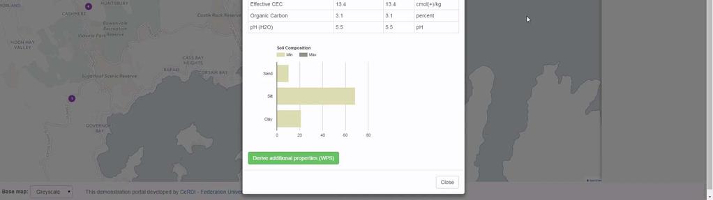
16 Demonstration Soil profiles and descriptions December 17 MANAAKI WHENUA LANDCARE RESEARCH PAGE 16
17 December 17 MANAAKI WHENUA LANDCARE RESEARCH PAGE 17 Results Created a simple information model of soils data Harmonised the structure and some content of soils data between agencies Brought data from different soil agencies together in applications for users (interoperability) Provided a way to describe and organise soil concepts, features, methods, etc (semantics) Started a conversation with Dave Blodgett at the USGS How do we link together all of our environmental data? How do we do it in a way that is the HTML for environmental data?

18 December 17 MANAAKI WHENUA LANDCARE RESEARCH PAGE 18 What does that even mean? First question Cross-domain science Integrating data from multiple domains Lower the data integration overhead
19 December 17 MANAAKI WHENUA LANDCARE RESEARCH PAGE 19 What does that even mean? Yeah, but the HTML for environmental data? HTML is pervasive web technology and used without thought or controversy. OGC X(G)ML and web services are widely regarded as a Bad Thing REST and JSON are a Good Thing (Depending on your perspective.) It s a pointless argument there s no one way of doing things but imagine
 Web being able to search for a monitoring station by name")
 Get a summary in a Google Knowledge Panel (or equivalent) Find out about")

20 December 17 MANAAKI WHENUA LANDCARE RESEARCH PAGE 20 Environmental Data on the (Google-able) Web being able to search for a monitoring station by name (location?) Get a summary in a Google Knowledge Panel (or equivalent) Find out about related features monitoring station -> reach -> river -> catchment -> moisture sensor -> paddock -> irrigator -> aquifer -> Data may be distributed across multiple data stores/agencies Standard interoperability problem, but
21 December 17 MANAAKI WHENUA LANDCARE RESEARCH PAGE 21 Environmental Data on the Web needs to be solved in a way that is friendly to web developers No strange formats, protocols or bewildering (and numerous) data structures They like ReST and JSON and get scared and angry when dealing with anything else But also need to maintain discipline If you want to seamlessly link data across servers the data need to be consistent standardized

22 December 17 MANAAKI WHENUA LANDCARE RESEARCH PAGE 22 Environmental Linked Feature Interoperability Experiment Demonstrate the use of existing and pending OGC standards for the encoding of environmental observation data in an integrated dataset of features linked according to ReSTful and Linked Data principles. Initiators: U.S. Geological Survey (US) Land Information New Zealand (NZ) BRGM (FR) Participants Horizons Regional Council (NZ) Manaaki Whenua - Landcare Research (NZ) Natural Resources Canada (CA) ESRI (US) Tumbling Walls (US) Meta-linkage (AU) INSPIRE (EU) From:
23 MANAAKI WHENUA LANDCARE RESEARCH PAGE 23 Applying OGC/W3C Best Practices The engine the ID and the link ReST with discipline GeoJSON, Well Known Text, KEEP IT SIMPLE! December 17 HTML landing pages with structured data mark-up Don t rely on specialist registries or catalogue services
24 December 17 MANAAKI WHENUA LANDCARE RESEARCH PAGE 24 JSON-LD JSON for the Semantic Web Need a disciplined approach some way of standardizing content Properties Defininitions Vocabularies Links (aka relations) JSON-LD Looks like JSON Linked/embedded context Binds to RDF Schema/ OWL ontology Objects (URIs) Can be converted to RDF
25 December 17 MANAAKI WHENUA LANDCARE RESEARCH PAGE 25 Use Cases NZ: Stream Monitoring Quantity / Quality (impacts of water allocation decisions): Monitoring sites Existing water allocations Diversions / discharges Water quality Blue line network NZ: Agriculture (soil moisture state for irrigation application decisions) Soil moisture time series Allowed to pump / consent data. Water allocation US: Watershed Boundary Dataset Monitoring Summary US and Canada: Monitoring Index France: Surface/ground water interaction France: Ground water level forecast And a bunch more


 December")

26 Demonstrations Not finished, nothing to be demonstrated (could show you but would have to kill you) December 17 MANAAKI WHENUA LANDCARE RESEARCH PAGE 26
27 December 17 MANAAKI WHENUA LANDCARE RESEARCH PAGE 27 (Preliminary) Results Can use JSON (as JSON-LD) and ReST (as Linked Data) Data can be linked across servers (well, it is the web) Data can be indexed for search engines The are useful core ontologies to standardize basic content SKOS, schema.org, SOSA, OWL-Time There are useful OGC application schema for environmental data WaterML 2.0 Parts 1 to 3; GroundwaterML 2; HY_Features; GeoSciML, But very few of them are RDF-ready (now OWL-RDF ontologies) Solves a mass-market problem but doesn t meet all needs Advanced geospatial querying Semantic web interencing/reasons Good entry point though
28 December 17 MANAAKI WHENUA LANDCARE RESEARCH PAGE 28 Where next? Honestly not sure Soil standards have ground to a halt in international politics (UN FAO etc) No technical problems, all social ELFIE first we need to finish it Some very interesting follow up projects Gateway drug get hooked on standards with the simple stuff, introduce advanced tech when needed Can be confident the Semantic Web is part of the future, and here it is


29 December 17 MANAAKI WHENUA LANDCARE RESEARCH PAGE 29 QUESTIONS? Soil IE stuff Engineering Report OGC16-088r1 GitHub (model, schema, examples) Sydney Demonstration YouTube:
OGC Environmental Data Standards for Monitoring and Mapping. Alistair Ritchie Research Data Architect/Engineer Informatics Team
 MANAAKI WH ENUA L ANDCARE RES EARCH OGC Environmental Data Standards for Monitoring and Mapping Alistair Ritchie Research Data Architect/Engineer Informatics Team April 18 MANAAKI WH ENUA L ANDCARE RES
Open Geospatial Consortium
 OGC Engineering Report OGC 16-088r1 Open Geospatial Consortium Publication Date: 2016-07-26 Approval Date: 2016-06-23 Posted Date: 2016-05-05 Reference number of this document: OGC 16-088r1 Reference URL
ISO/TC211 Outreach Seminar Wednesday 29 November Lecture Theatre 2 Rutherford House Pipitea Campus Victoria University of Wellington
 ISO/TC211 Outreach Seminar Wednesday 29 November 2017 Lecture Theatre 2 Rutherford House Pipitea Campus Victoria University of Wellington 1030 Morning tea/coffee (30 mins) Registration for non-tc211. 1100
FINNISH LINKED DATA PILOTS
 FINNISH LINKED DATA PILOTS Kai Koistinen Data Linking by Indirect Reference Systems -workshop 5.9.2018 1 NLS FINLAND National Land Survey of Finland National mapping and cadastral agency Geodetic research
Advancing Flood Detection and Preparedness through GEOSS Water Services
 Advancing Flood Detection and Preparedness through GEOSS Water Services David K. Arctur University of Texas at Austin Open Geospatial Consortium (OGC) CAHMDA/DAFOH Joint Workshop University of Texas at
Spatial Data on the Web Working Group. Geospatial RDA P9 Barcelona, 5 April 2017
 Spatial Data on the Web Working Group Geospatial IG @ RDA P9 Barcelona, 5 April 2017 Spatial Data on the Web Joint effort of the World Wide Web Consortium (W3C) and the Open Geospatial Consortium (OGC)
Reducing Consumer Uncertainty
 Spatial Analytics Reducing Consumer Uncertainty Eliciting User and Producer Views on Geospatial Data Quality Introduction Cooperative Research Centre for Spatial Information (CRCSI) in Australia Communicate
Spatially Enabled Society
 International Seminar on Land Administration Trends and Issues in Asia and the Pacific Region Spatially Enabled Society Abbas Rajabifard Vice Chair PCGIAP-WG3 Vice-President (President Elect), GSDI Association
INSPIRE - A Legal framework for environmental and land administration data in Europe
 INSPIRE - A Legal framework for environmental and land administration data in Europe Dr. Markus Seifert Bavarian Administration for Surveying and Cadastre Head of the SDI Office Bavaria Delegate of Germany
Global Geospatial Information Management Country Report Finland. Submitted by Director General Jarmo Ratia, National Land Survey
 Global Geospatial Information Management Country Report Finland Submitted by Director General Jarmo Ratia, National Land Survey Global Geospatial Information Management Country Report Finland Background
UN-GGIM Arab States Meeting Welcome Address. Denise McKenzie Open Geospatial Consortium 21 February 2017 Doha, Qatar
 UN-GGIM Arab States Meeting Welcome Address Denise McKenzie Open Geospatial Consortium 21 February 2017 Doha, Qatar The Open Geospatial Consortium Not-for-profit, international voluntary consensus standards
The CUAHSI Hydrologic Information System
 The CUAHSI Hydrologic Information System Presented by Dr. Tim Whiteaker The University of Texas at Austin 18 November, 2010 Session T1B About the Speaker PhD 2004 Research Associate What You Will Learn
Integrating information, HPC and organisations for Earth Science innovation
 Integrating information, HPC and organisations for Earth Science innovation Dr Robert Woodcock Exploration and Mining Lesley Wyborn Geoscience Australia The Components of Auscope AuScope Infrastructure
INSPIREd solutions for Air Quality problems Alexander Kotsev
 INSPIREd solutions for Air Quality problems Alexander Kotsev www.jrc.ec.europa.eu Serving society Stimulating innovation Supporting legislation The European data puzzle The European data puzzle 24 official
INSPIRE General Introduction & Service Architecture
 INSPIRATION Spatial Data Infrastructure in the Western Balkans INSPIRE General Introduction & Service Architecture 1st National INSPIRATION Workshop Croatia November 21-22, 2012 A multi-countryprojectfunded
The PREVIEW Global Risk Data Platform: a geoportal to serve and share global data on risk to natural hazards
 The PREVIEW Global Risk Data Platform: a geoportal to serve and share global data on risk to natural hazards Gregory Giuliani (UNEP/GRID-Geneva & University of Geneva/enviroSPACE ) http://www.grid.unep.ch
Roadmap to interoperability of geoinformation
 Roadmap to interoperability of geoinformation and services in Europe Paul Smits, Alessandro Annoni European Commission Joint Research Centre Institute for Environment and Sustainability paul.smits@jrc.it
Georef - Linked Data Deployment for Spatial Data; Finnish Initiative
 Georef - Linked Data Deployment for Spatial Data; Finnish Initiative Esa TIAINEN, Finland Key words: Linked Data, Semantics, Ontology, Web, RDF, Big Data SUMMARY 'Georef' is an initiative for a service
Atmospheric Science and GIS Interoperability issues: some Data Model and Computational Interface aspects
 UNIDATA Boulder, Sep. 2003 Atmospheric Science and GIS Interoperability issues: some Data and Computational Interface aspects Stefano Nativi University of Florence and IMAA-CNR Outline Service-Oriented
Technical Specifications. Form of the standard
 Used by popular acceptance Voluntary Implementation Mandatory Legally enforced Technical Specifications Conventions Guidelines Form of the standard Restrictive Information System Structures Contents Values
WEB MAP SERVICE (WMS) FOR GEOLOGICAL DATA GEORGE TUDOR
 FOR GEOLOGICAL DATA GEORGE TUDOR") WEB MAP SERVICE (WMS) FOR GEOLOGICAL DATA GEORGE TUDOR WEB MAP SERVICE (WMS) - GENERALITIES Projects with data from different sources Geological data are in different GIS software format Large amount of
WEB MAP SERVICE (WMS) FOR GEOLOGICAL DATA GEORGE TUDOR WEB MAP SERVICE (WMS) - GENERALITIES Projects with data from different sources Geological data are in different GIS software format Large amount of
Spatial data interoperability and INSPIRE compliance the platform approach BAGIS
 Spatial data interoperability and INSPIRE compliance the platform approach BAGIS BAGIS Voluntary, independent, public, non-profit organization; Organization with main mission to promote the growth of the
Hosted by Esri Official Distributor
 Hosted by Esri Official Distributor Esri European User Conference October 15-17, 2012 Oslo, Norway Hosted by Esri Official Distributor Interoperability and Standards Support in ArcGIS 10.1 Roberto Lucchi
Discovery and Access to Global Water Data, Maps and Services
 Discovery and Access to Global Water Data, Maps and Services David K. Arctur, PhD david.arctur@utexas.edu University of Texas at Austin Open Geospatial Consortium (OGC) Esri International User Conference
Modern Education at Universities: Improvements through the Integration of a Spatial Data Infrastructure SDI into an e-learning Environment
 Modern Education at Universities: Improvements through the Integration of a Spatial Data Infrastructure SDI into an e-learning Environment Ingo Simonis Institute for Geoinformatics, University of Muenster
The Open Geospatial Consortium and EarthCube
 The Open Geospatial Consortium and EarthCube An EarthCube Technology Paper Prepared by David Maidment 1, Ben Domenico 2, Alastair Gemmell 3, Kerstin Lehnert 4, David Tarboton 5 and Ilya Zaslavsky 6 Introduction
The state-of-the-art of the Finnish SDI. Arctic SDI WG Meeting
 The state-of-the-art of the Finnish SDI Arctic SDI WG Meeting Moscow 8.9.2011 Esa Tiainen Development Centre 1 NATIONAL LAND SURVEY DOWN TO EARTH Contents Legal framework Coordination structure Network
Australian Earth Science Research Spatial Information Infrastructure
 AN ORGANISATION FOR A NATIONAL EARTH SCIENCE INFRASTRUCTURE PROGRAM Australian Earth Science Research Spatial Information Infrastructure Dr Robert Woodcock AuScope Grid - Director Outline Why build an
The Open Geospatial Consortium and EarthCube
 The Open Geospatial Consortium and EarthCube An EarthCube Technology Paper Prepared by David Maidment 1, Ben Domenico 2, Alastair Gemmell 3, Kerstin Lehnert 4, David Tarboton 5 and Ilya Zaslavsky 6 Introduction
Semantic Evolution of Geospatial Web Services: Use Cases and Experiments in the Geospatial Semantic Web
 Semantic Evolution of Geospatial Web Services: Use Cases and Experiments in the Geospatial Semantic Web Joshua Lieberman, Todd Pehle, Mike Dean Traverse Technologies, Inc., Northrop Grumman Information
The Time is Right to Commit to Use International Standards. Empowering Australia with Spatial Information
 The Time is Right to Commit to Use International Standards Empowering Australia with Spatial Information OUTLINE Energy Industry Metadata Standards Initiative ISO 19115 Revision Australian initiatives
ArcGIS Online Tools and Water-Related Web Services You Can Use Every Day of Your Life!
 ArcGIS Online Tools and Water-Related Web Services You Can Use Every Day of Your Life! Brian Rowley, PE, CFM FMA 2014 Annual Conference 1 Gold Rush (49ers) John Sutter Sutter s Mill South fork of American
Status Finland Eero Hietanen NLS-FI SDI.Next: Linked Spatial Data in Europe 12th of March 2019
 Open European Location Services Title Speaker Event Date Status Finland Eero Hietanen NLS-FI SDI.Next: Linked Spatial Data in Europe 12th of March 2019 #OpenELS #OpenELS Content 1. National Geospatial
Introduction to geoprocessing services using SEXTANTE. Víctor Olaya SEXTANTE Geospatial Services
 Introduction to geoprocessing services using SEXTANTE. Víctor Olaya SEXTANTE Geospatial Services Overview Quick introduction to SEXTANTE Client/Server fundamentals Standards for web-based geoservices SEXTANTE
Methodological Chain for Hydrological Management with Web-GIS Applications
 Advances in Geosciences Konstantinos Perakis & Athanasios Moysiadis, Editors EARSeL, 2012 Methodological Chain for Hydrological Management with Web-GIS Applications Alexandros Konstantinidis 1, Eleni Tzanou
ISO Series Standards in a Model Driven Architecture for Landmanagement. Jürgen Ebbinghaus, AED-SICAD
 ISO 19100 Series Standards in a Model Driven Architecture for Landmanagement Jürgen Ebbinghaus, AED-SICAD 29.10.2003 The Company 100% SIEMENS PTD SIEMENS Business Services Shareholder & Strategic Business
Perform. Xcel. Lead. Presenter. Raghavendran S. GM Technical (GIS)
") Perform. Xcel. Lead. Presenter Raghavendran S GM Technical (GIS) Perform. Xcel. Lead. The Trademarks/Logos belong to the respective companies 2015 PIXEL SOFTEK PVT. LTD. 1 Incorporated in 1996 HQ in Bangalore,
Perform. Xcel. Lead. Presenter Raghavendran S GM Technical (GIS) Perform. Xcel. Lead. The Trademarks/Logos belong to the respective companies 2015 PIXEL SOFTEK PVT. LTD. 1 Incorporated in 1996 HQ in Bangalore,
Implementing INSPIRE Geoportal in Turkey
 Implementing INSPIRE Geoportal in Turkey Gencay SERTER City and Regional Planner 1 Presentation Plan Introduction INSPIRE and Turkey Importance of al Spatial Planning Portal Logical&Legal Hierarchy GeoPortal
Paper UC1351. Conference: User Conference Date: 08/10/2006 Time: 8:30am-9:45am Room: Room 23-B (SDCC)
") Conference: User Conference Date: 08/10/2006 Time: 8:30am-9:45am Room: Room 23-B (SDCC) Title of Paper: Increasing the Use of GIS in the Federal Government Author Name: Miss Abstract This presentation
Conference: User Conference Date: 08/10/2006 Time: 8:30am-9:45am Room: Room 23-B (SDCC) Title of Paper: Increasing the Use of GIS in the Federal Government Author Name: Miss Abstract This presentation
Geospatial Standards Support - An Overview. Marten Hogeweg & Satish Sankaran
 Geospatial Standards Support - An Overview Marten Hogeweg & Satish Sankaran Agenda Interoperability and Standards ArcGIS Open, Interoperable and Standards Compliant Esri Open initiatives Understanding
Global 3D Models with Local Content
 Gunnar Misund Associate Professor Head of Environmental Computing gunnar.misund@hiof.no - Morten Granlund, Scientfic Assistant Herman Kolås, Master Student Mats Lindh, Master Student - Østfold University
Discovery and Access of Geospatial Resources using the Geoportal Extension. Marten Hogeweg Geoportal Extension Product Manager
 Discovery and Access of Geospatial Resources using the Geoportal Extension Marten Hogeweg Geoportal Extension Product Manager DISCOVERY AND ACCESS USING THE GEOPORTAL EXTENSION Geospatial Data Is Very
OGC and the Relevance of Standards for Environmental Matters
 and the Relevance of Standards for Environmental Matters Scott Simmons Executive Director, Standards Program, 1 December 2017 Copyright 2017 Open Geospatial Consortium So what brings so many standards
Overview of Geospatial Open Source Software which is Robust, Feature Rich and Standards Compliant
 Overview of Geospatial Open Source Software which is Robust, Feature Rich and Standards Compliant Cameron SHORTER, Australia Key words: Open Source Geospatial Foundation, OSGeo, Open Standards, Open Geospatial
Sharing soil information with the help of INSPIRE, key challenges with soil data management
 Sharing soil information with the help of INSPIRE, key challenges with soil data management Katharina Feiden e-mail: gssoil@portalu.de GS Soil: project outline GS Soil: Assessment and strategic development
Richard R. Heim Jr. Michael J. Brewer
 Linking GDIS Data Sets Using the NIDIS Drought Portal Richard R. Heim Jr. Michael J. Brewer NOAA/NESDIS/ Asheville, North Carolina International Global Drought Information System Workshop: Next Steps Caltech
econtentplus GS Soil
 econtentplus GS Soil General aims Assessment and strategic development of INSPIRE compliant Geodata-Services for European Soil Data BPN on basis of the EU 2007/2/EC (INSPIRE) Directive for Annex III theme
Geospatial Semantics for Topographic Data
 Geospatial Semantics for Topographic Data E. Lynn Usery U.S. Geological Survey Abstract. Whereas The National Map of the U.S. Geological Survey is based on data models and processes of geographic information
MOD Ontology. Ian Bailey, Model Futures Michael Warner, MOD ICAD
 MOD Ontology Ian Bailey, Model Futures (ian@modelfutures.com) Michael Warner, MOD ICAD MOD Ontology Team Introduction Michael Warner, Bose Lawanson, MOD Ian Bailey, Model Futures Chris Partridge, 42 Objects
Implementing strategy for the Infrastructure for Spatial Information in Europe - INSPIRE Paul Smits
 Implementing strategy for the Infrastructure for Spatial Information in Europe - INSPIRE Paul Smits European Commission DG Joint Research Centre Institute for Environment and Sustainability Ispra, Italy
Charter for the. Information Transfer and Services Architecture Focus Group
 for the Information Transfer and Services Architecture Focus Group 1. PURPOSE 1.1. The purpose of this charter is to establish the Information Transfer and Services Architecture Focus Group (ITSAFG) as
Laying the Foundations for Global Transdisciplinary Integration of Data from the Physical Sciences and the Social Sciences
 Laying the Foundations for Global Transdisciplinary Integration of Data from the Physical Sciences and the Social Sciences Lesley Wyborn 1, Simon Cox 2, Simon Hodson 3 and Geoffrey Boulton 4 1 National
The Canadian Ceoscience Knowledge Network. - A Collaborative Effort for Unified Access to Ceoscience Data
 The Canadian Ceoscience Knowledge Network - A Collaborative Effort for Unified Access to Ceoscience Data The Canadian Geoscience Knowledge Network A Collaborative Effort for Unified Access to Geoscience
Toward A Foundational Hydro Ontology For Water Data Interoperability
 City University of New York (CUNY) CUNY Academic Works International Conference on Hydroinformatics 8-1-2014 Toward A Foundational Hydro Ontology For Water Data Interoperability Boyan Brodaric Torsten
AS/NZS ISO :2015
 Australian/New Zealand Standard Geographic information Reference model Part 1: Fundamentals Superseding AS/NZS ISO 19101:2003 AS/NZS ISO 19101.1:2015 (ISO 19101-1:2014, IDT) AS/NZS ISO 19101.1:2015 This
Building a 4-D Weather Data Cube for the NextGen Initial Operating Capability (IOC)
") Building a 4-D Weather Data Cube for the NextGen Initial Operating Capability (IOC) Friends/Partners in Aviation Weather Vision Forum July 15, 2008 Bruce Lambert - DoD Tom Ryan FAA Jason Tuell NWS 1 Overview
Building a 4-D Weather Data Cube for the NextGen Initial Operating Capability (IOC) Friends/Partners in Aviation Weather Vision Forum July 15, 2008 Bruce Lambert - DoD Tom Ryan FAA Jason Tuell NWS 1 Overview
Enabling Access to Arctic Location Based Information
 Enabling Access to Arctic Location Based Information Jani Kylmäaho Arctic SDI Geoportal WG Lead National Land Survey of Finland INSPIRE Conference 29 September 2016 http://wallpaper.imcphoto.net/animals/polar
Application Domain Extensions definition for crowd source and Volunteer Geographic Information for smart-cities services deployment.
 Application Domain Extensions definition for crowd source and Volunteer Geographic Information for smart-cities services deployment. F. Prandi, R. de Amicis, P. Parslow, M. Ford, E. D Hondt Outlook Introduction
CLICK HERE TO KNOW MORE
 CLICK HERE TO KNOW MORE Geoinformatics Applications in Land Resources Management G.P. Obi Reddy National Bureau of Soil Survey & Land Use Planning Indian Council of Agricultural Research Amravati Road,
The Global Runoff Data Centre (GRDC) Report on selected GRDC activities during the inter-sessional period Ulrich Looser
 Report on selected GRDC activities during the inter-sessional period Ulrich Looser") The Global Runoff Data Centre (GRDC) Report on selected GRDC activities during the inter-sessional period 2008-2012 Ulrich Looser Koblenz 09/2012 1 1. Introduction This report summarises some of the activities
The Global Runoff Data Centre (GRDC) Report on selected GRDC activities during the inter-sessional period 2008-2012 Ulrich Looser Koblenz 09/2012 1 1. Introduction This report summarises some of the activities
What s New in Topographic Information - USGS National Map
 + What s New in Topographic Information - USGS National Map SARGIS Workshop November 14, 2016 Rob Dollison, 703-648-5724 rdollison@usgs.gov + USGS 2 National Geospatial Program The National Geospatial
Spatial Data Infrastructure Concepts and Components. Douglas Nebert U.S. Federal Geographic Data Committee Secretariat
 Spatial Data Infrastructure Concepts and Components Douglas Nebert U.S. Federal Geographic Data Committee Secretariat August 2009 What is a Spatial Data Infrastructure (SDI)? The SDI provides a basis for
From the Venice Lagoon Atlas towards a collaborative federated system
 From the Venice Lagoon Atlas towards a collaborative federated system City of Venice Alessandro Mulazzani CORILA Consortium for Coordination of Research Activities Concerning the Venice Lagoon System ISMAR-CNR
Technical Framework Methodology as a core of building up the NSDI NSDI Implementation Specifics in Serbia
 Technical Framework Methodology as a core of building up the NSDI NSDI Implementation Specifics in Serbia Luka Jovičić SDI Consultant@ Gramont Ltd. Aleksandar Dedić RGA NSDI department Dragica Pajić RGA
The importance of persistent URIs for the implementation of INSPIRE
 The importance of persistent URIs for the implementation of INSPIRE INSPIRE Conference 2012, Istanbul Clemens Portele, interactive instruments GmbH Drafting Team Data Specifications (Chair) Directive,
Improving the Interoperability of Earth Observations. An EarthCube White Paper. Jeffery S. Horsburgh 1, David G. Tarboton 1.
 Improving the Interoperability of Earth Observations An EarthCube White Paper Jeffery S. Horsburgh 1, David G. Tarboton 1 October 16, 2011 1. Introduction In the history of science, many significant advances
Semantics, ontologies and escience for the Geosciences
 Semantics, ontologies and escience for the Geosciences Femke Reitsma¹, John Laxton², Stuart Ballard³, Werner Kuhn, Alia Abdelmoty ¹femke.reitsma@ed.ac.uk: School of Geosciences, Edinburgh University ²
Pushing the Standards Edge: Collaborative Testbeds to Accelerate Standards Development and Implementation
 Pushing the Standards Edge: Collaborative Testbeds to Accelerate Standards Development and Implementation Mark E. Reichardt President mreichardt@opengeospatial.org 31 October 2006 2006 Open Geospatial
A Web Service based U.S. Cropland Visualization, Dissemination and Querying System
 A Web Service based U.S. Cropland Visualization, Dissemination and Querying System Rick Mueller and Zhengwei Yang USDA/National Agricultural Statistics Service Weiguo Han and Liping Di GMU/Center for Spatial
A Case Study for Semantic Translation of the Water Framework Directive and a Topographic Database
 A Case Study for Semantic Translation of the Water Framework Directive and a Topographic Database Angela Schwering * + Glen Hart + + Ordnance Survey of Great Britain Southampton, U.K. * Institute for Geoinformatics,
a national geological survey perspective François ROBIDA BRGM (French Geological Survey)
") a national geological survey perspective François ROBIDA BRGM (French Geological Survey) Pre-Conference Seminar on Socio-Economic Value of Geospatial for National and Regional Development 21 August 2017,
a national geological survey perspective François ROBIDA BRGM (French Geological Survey) Pre-Conference Seminar on Socio-Economic Value of Geospatial for National and Regional Development 21 August 2017,
Data Origin. Ron van Lammeren CGI-GIRS 0910
 Data Origin Ron van Lammeren CGI-GIRS 0910 How to obtain geodata? Geo data initiative Executive Order 12906, "Coordinating Geographic Data Acquisition and Access: The National Spatial Data Infrastructure,"
A Model of GIS Interoperability Based on JavaRMI
 A Model of GIS Interoperability Based on Java Gao Gang-yi 1 Chen Hai-bo 2 1 Zhejiang University of Finance & Economics, Hangzhou 310018, China 2 College of Computer Science and Technology, Zhejiang UniversityHangzhou
NAG-City Expert Workshop Oslo 8-9. October 2012 SOSI standards and mapping for Europe (INSPIRE)
") NAG-City Expert Workshop Oslo 8-9. October 2012 SOSI standards and mapping for Europe (INSPIRE) Per Ryghaug, Geomatics The Norwegian national standard on geographic information - SOSI Started in 1984 NGU
NAG-City Expert Workshop Oslo 8-9. October 2012 SOSI standards and mapping for Europe (INSPIRE) Per Ryghaug, Geomatics The Norwegian national standard on geographic information - SOSI Started in 1984 NGU
Geological applications using geospatial standards an example from OneGeology-Europe and GeoSciML
 Geological applications using geospatial standards an example from OneGeology-Europe and GeoSciML John Laxton 1, Jean-Jacques Serrano 2, Agnes Tellez-Arenas 2 1 British Geological Survey, Edinburgh, United
Web 3D Service & CityGML Update
 Technische Universität Berlin Web 3D Service & CityGML Update Thomas H. Kolbe Institute for Geodesy and Geoinformation Science Berlin University of Technology kolbe@igg.tu-berlin.de 2nd of November, 2007
Portals: Standards in Action
 Portals: Standards in Action David Danko ISO TC 211 Metadata Project Leader GIS Standards Consultant-ESRI. Metadata Portals Portal gateway, place of entry Producers Advertise, expose products Share information
Land Board, NW Services and SDI Tambet Tiits, FRICS
 Land Board, NW Services and SDI Tambet Tiits, FRICS 07.09.2016 200th anniversary of the Struve Geodetic Arc Friedrich Georg Wilhelm Struve and Carl Friedrich Tenner Struve Geodetic Arc The Struve Geodetic
Data Origin. How to obtain geodata? Ron van Lammeren CGI-GIRS 0910
 Data Origin How to obtain geodata? Ron van Lammeren CGI-GIRS 0910 Spatial Data interest Improvement of policy making. ± 90% of all information used by government has spatial characteristics SPATIAL INFORMATION
A contribution to GEOSS from the SDI for Georesources in Africa
 A contribution to GEOSS from the SDI for Georesources in Africa A. TELLEZ-ARENAS BRGM, France in behalf of: Dr. Marc URVOIS Project Coordinator BRGM, France Mineral Resources Division INSPIRE Conference
Open Geospatial Consortium activities in the Maritime domain
 Open Geospatial Consortium activities in the Maritime domain Scott Simmons Executive Director, Standards Program General Maritime efforts participants Alliance partners IHO ISO / TC 211 Members Danish
Basic Dublin Core Semantics
 Basic Dublin Core Semantics DC 2006 Tutorial 1, 3 October 2006 Marty Kurth Head of Metadata Services Cornell University Library Getting started Let s introduce ourselves Let s discuss our expectations
Benefits of Open Standards how to engage with OGC
 Benefits of Open Standards how to engage with OGC Athina Trakas OGC, Inc. Director Business Development Europe atrakas@opengeospatial.org With support from Mark Reichardt (President & CEO) and Martin Klopfer
Visualizing Uncertainty In Environmental Work-flows And Sensor Streams
 Visualizing Uncertainty In Environmental Work-flows And Sensor Streams Karthikeyan Bollu Ganesh and Patrick Maué Institute for Geoinformatics (IFGI), University of Muenster, D-48151 Muenster, Germany {karthikeyan,pajoma}@uni-muenster.de
SDI-Challenges European perspective
 THE HIGH LEVEL FORUM ON GLOBAL GEOSPATIAL INFORMATION MANAGEMENT Seoul, Republic of Korea, 24-26 October 2011 Session 1: Challenges in geospatial policy formation and institutional arrangements SDI-Challenges
Hydrologic Modelling of the Upper Malaprabha Catchment using ArcView SWAT
 Hydrologic Modelling of the Upper Malaprabha Catchment using ArcView SWAT Technical briefs are short summaries of the models used in the project aimed at nontechnical readers. The aim of the PES India
THE SPATIAL DATA SERVER BASED ON OPEN GIS STANDARDS IN HETEROGENEOUS DISTRIBUTED ENVIRONMENT
 Geoinformatics 2004 Proc. 12th Int. Conf. on Geoinformatics Geospatial Information Research: Bridging the Pacific and Atlantic University of Gävle, Sweden, 7-9 June 2004 THE SPATIAL DATA SERVER BASED ON
Harmonizing spatial databases and services at local and regional level
 Harmonizing spatial databases and services at local and regional level A. Ionita 1, M. Caian 2, V. Vassilev 3, V. Craciunescu 2, I. Nedelcu 4 1 Research Institute for Artificial Intelligence, Bucuresti,
GIS at UCAR. The evolution of NCAR s GIS Initiative. Olga Wilhelmi ESIG-NCAR Unidata Workshop 24 June, 2003
 GIS at UCAR The evolution of NCAR s GIS Initiative Olga Wilhelmi ESIG-NCAR Unidata Workshop 24 June, 2003 Why GIS? z z z z More questions about various climatological, meteorological, hydrological and
Conceptual Modelling within The OGC MetOcean Domain Working Group
 Conceptual Modelling within The OGC MetOcean Domain Working Group 21 st EGOWS Mtg, 1 st -4 th June 2010, ECMWF Dominic Lowe, dominiclowe@stfc.ac.uk British Atmospheric Data Centre, http://badc.nerc.ac.uk
Harmonisation of Spatial Planning Data
 INSPIRE Conference 18 June 2011 Edinburgh, Great Britain Harmonisation of Spatial Planning Data Tomas Mildorf University of West Bohemia mildorf@centrum.cz Pilsen, Czech Republic Co-funded by the Community
OGC Meteorology and Oceanography Domain Working Group progress report
 OGC Meteorology and Oceanography Domain Working Group progress report 2 nd Workshop on the use of GIS/OGC standards in meteorology Marie-Françoise Voidrot-Martinez, Chris Little Co-chairs OGC Met Ocean
INSPIRing Geospatial Framework For Local Administrations
 This project is financed by the European Union and the Republic of Turkey Presented at the FIG Congress 2018, May 6-11, 2018 in Istanbul, Turkey National Programme for Turkey 2010 Instrument for Pre-Accession
EXPECTATIONS OF TURKISH ENVIRONMENTAL SECTOR FROM INSPIRE
 EXPECTATIONS OF TURKISH ENVIRONMENTAL SECTOR FROM INSPIRE June, 2010 Ahmet ÇİVİ Tuncay DEMİR INSPIRE in the Eyes of MoEF Handling of Geodata by MoEF Benefits Expected TEIEN First Steps for INSPIRE Final
Overview of CityGML. Dave Capstick, Ordnance Survey Research Department
 Overview of CityGML Dave Capstick, Ordnance Survey Research Department Introduction Why is citygml necessary CityGML development who is responsible? Ordnance Surveys interest 3D modelling basic concepts
Next Generation Spatial Infrastructures Program Update
 Towards Spatial Knowledge Infrastructure Our research program has set itself the task of defining what the Next Generation SDI will be and Dr Phil Collier (CRCSI Research Director) introduced some of the
BIM and INSPIRE, for a better integration of built infrastructures in their environment : the MINnD project
 BIM and INSPIRE, for a better integration of built infrastructures in their environment : the MINnD project François ROBIDA Christophe CASTAING Strasbourg, > 1 8 septembre 2017 ABOUT BIM Building Information
GIS in Weather and Society
 GIS in Weather and Society Olga Wilhelmi Institute for the Study of Society and Environment National Center for Atmospheric Research WAS*IS November 8, 2005 Boulder, Colorado Presentation Outline GIS basic
THE WASHINGTON COASTAL ATLAS
 THE ICAN COASTAL ATLAS MEDIATOR PROTOTYPE AND CONNECTING THE WASHINGTON COASTAL ATLAS Liz O Dea 1, Yassine Lassoued 2, Tanya Haddad 3, Declan Dunne 2 1 GIS Services Unit, WA State Dept. of Ecology 2 Coastal
Geological information for Europe : Towards a pan-european Geological Data Infrastructure
 Geological information for Europe : Towards a pan-european Geological Data Infrastructure Integrating geoscientific information for EU competitiveness Co-funded by the European Union European societal