Status Finland Eero Hietanen NLS-FI SDI.Next: Linked Spatial Data in Europe 12th of March 2019
|
|
|
- Christina Terry
- 5 years ago
- Views:
Transcription
1 Open European Location Services Title Speaker Event Date Status Finland Eero Hietanen NLS-FI SDI.Next: Linked Spatial Data in Europe 12th of March 2019 #OpenELS


2 #OpenELS
3 Content 1. National Geospatial URI Strategy in Finland 2. AU and GN as Linked Data Prototype Open European Location Services 3. Linked Data Pilot on Building data Geospatial Platform #OpenELS
4 URI STRATEGY National recommendation on implementing URIs on geospatial data JHS 193 Unique identifiers of the geographic information Released 2015 Available in English Defines the structure of spatial data URI: URI: INSPIRE URI:
5 URI STRATEGY Defines a domain for geospatial data URIs : spatialdata.fi Paikkatiedot.fi: Centralized national spatial data URI redirection service Maintained by NLS-FI Implemented using CSIROs PID Service Software
6 Content 1. National Geospatial URI Strategy in Finland 2. AU and GN as Linked Data Prototype Open European Location Services 3. Linked Data Pilot on Building data Geospatial Platform #OpenELS
7 Geographical Names (GN) Dataset National dataset of geographical names NamedPlace including 1 to many geographical names (flatted schema) named places Download service (GML) #OpenELS

.")
 Two versions of geometries: with or without sea areas.")
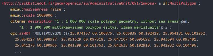
8 Administrative Units (AU) Dataset National dataset of administrative units Boundaries based on NLS FI cadastral registry Includes Municipalities (311), Regions (19) and Regional State Administrative Agencies (6). Different generalization levels available (original scale 1 : ) Two versions of geometries: with or without sea areas. (For RDF only 1 : without sea areas in this case). #OpenELS
9 OpenELS: GN and AU to Linked Data Transformation: Download services PostGIS (with QGIS) Jena RDF store (with Python RDFLib). Services: Jena Fuseki SPARQL endpoint: URI Service (RDF-formats, no html) Paikkatiedot.fi URIs (Municipality of Helsinki) Own URIs for geometries: (geometry of Helsinki) (Named place of Helsinki) Datastory (with Netherlands, Norway and Spain) #OpenELS

10 #OpenELS au:administrativeunit and geometry
11 Content 1. National Geospatial URI Strategy in Finland 2. AU and GN as Linked Data Prototype Open European Location Services 3. Linked Data Pilot on Building data Geospatial Platform #OpenELS
12 LD PILOT ON BU THEME Geospatial Platform project (2018 ) Platform collects spatial data from various public administration providers and makes them available to users Harmonized data models (national and INSPIRE) Standard services (WMS, WFS ) National Topographic Database is one of the subprojects Renewal of the NLS s topographic database data models, production processes Design and development of Buildings theme during Not in production yet, planned productional deployment 2020 with Geospatial Platform The goal: best available public administration buildings data in 2D and 3D Data from the renewed topographic database as well as from municipalities Every building has a persistent http URI
13 LD PILOT ON BU THEME Linked Data product pilot Automatic scripts for generating RDF data from relational spatial database (PostGIS) Data was stored as triples in RDF database (Apache Jena Fuseki) Data maintenance process was also succesfully automated in pilot Up-to-date Buildings as Linked Data product Buildings data was linked with the named building (from GN pilot) Also links to Wikipedia and Wikidata HTML data cards and RDF URI service was built on top of the SPARQL endpoint. 13
14 Paikkatiedot.fi redirection service Redirect NTDB ETL tool (Java) Onetime load Graph Store Protocol Fuseki SPARQL SPARQL RDFBrowser Ontology Dataset resources Building resources Event update SPARQL UPDATE Jena TDB Building versions Code lists (SKOS) Resources provided in different formats (content negotiation) 14

15

16 COMBINING INFORMATION TO NTDB BUILDINGS 16

17 17
18 CONCLUSIONS Statistics GN General Finnish Ontology YSO Archives, libraries, museums SU BU AD AU There are already a lot of relationships between datasets GN theme is the glue between many themes Persistent HTTP URIs and common ontologies are vital for linking dataobjects RDF/SPARQL is much more applicable than GML/WFS when combining data from different sources LD approach can bring most benefit for users who need to combine data from many source 18

19 MORE INFO:
FINNISH LINKED DATA PILOTS
 FINNISH LINKED DATA PILOTS Kai Koistinen Data Linking by Indirect Reference Systems -workshop 5.9.2018 1 NLS FINLAND National Land Survey of Finland National mapping and cadastral agency Geodetic research
Georef - Linked Data Deployment for Spatial Data; Finnish Initiative
 Georef - Linked Data Deployment for Spatial Data; Finnish Initiative Esa TIAINEN, Finland Key words: Linked Data, Semantics, Ontology, Web, RDF, Big Data SUMMARY 'Georef' is an initiative for a service
From Geographics Stella to Bentley Map Stella Map. Kimmo Soukki, Account Manager Bentley Finland
 From Geographics Stella to Bentley Map Stella Map Kimmo Soukki, Account Manager Bentley Finland This presentation Stella? Why migrate? New Bentley Stella Map - How it is done? Data migration Bonuses? What
The state-of-the-art of the Finnish SDI. Arctic SDI WG Meeting
 The state-of-the-art of the Finnish SDI Arctic SDI WG Meeting Moscow 8.9.2011 Esa Tiainen Development Centre 1 NATIONAL LAND SURVEY DOWN TO EARTH Contents Legal framework Coordination structure Network
Contextualizing Historical Places in a Gazetteer by Using Historical Maps and Linked Data
 Contextualizing Historical Places in a Gazetteer by Using Historical Maps and Linked Data Esko Ikkala, Jouni Tuominen, and Eero Hyvönen Semantic Computing Research Group (SeCo), Aalto University http://www.seco.tkk.fi/,
Influence of INSPIRE on European/national data specifications
 www.eurogeographics.org Influence of INSPIRE on European/national data specifications Saulius Urbanas, EuroGeographics 20 th June 2017 Copyright 2013 EuroGeographics EuroGeographics 46 European countries
Solving the European Data Puzzle Simplifying INSPIRE Challenges and Usage. con terra GmbH Dipl.-Ing. Mark Döring
 Solving the European Data Puzzle Simplifying INSPIRE Challenges and Usage con terra GmbH Dipl.-Ing. Mark Döring INSPIRE Reference Projects GeoBAK 2.0 Project // INSPIRE Data & Services The Project Evolution
Estonian approach to implementation of INSPIRE directive. Sulev Õitspuu Head of Bureau of Geoinfosystems Estonian Land Board
 Estonian approach to implementation of INSPIRE directive Sulev Õitspuu Head of Bureau of Geoinfosystems Estonian Land Board 13.06.2016 Contents - INSPIRE coordination in Estonia - INSPIRE implementation
A Data Repository for Named Places and Their Standardised Names Integrated With the Production of National Map Series
 A Data Repository for Named Places and Their Standardised Names Integrated With the Production of National Map Series Teemu Leskinen National Land Survey of Finland Abstract. The Geographic Names Register
Paper UC1351. Conference: User Conference Date: 08/10/2006 Time: 8:30am-9:45am Room: Room 23-B (SDCC)
") Conference: User Conference Date: 08/10/2006 Time: 8:30am-9:45am Room: Room 23-B (SDCC) Title of Paper: Increasing the Use of GIS in the Federal Government Author Name: Miss Abstract This presentation
Conference: User Conference Date: 08/10/2006 Time: 8:30am-9:45am Room: Room 23-B (SDCC) Title of Paper: Increasing the Use of GIS in the Federal Government Author Name: Miss Abstract This presentation
ESDIN Results from a Crossborder INSPIRE Preparatory Project. Jörgen Hartnor, Lantmäteriet.
 ESDIN Results from a Crossborder INSPIRE Preparatory Project Jörgen Hartnor, Lantmäteriet www.esdin.eu Ett econtentplus Best Practice Network projekt September 2008 February 2011 Coordinated by EuroGeographics
19.2 Geographic Names Register General The Geographic Names Register of the National Land Survey is the authoritative geographic names data
 Section 7 Technical issues web services Chapter 19 A Data Repository for Named Places and their Standardised Names Integrated with the Production of National Map Series Teemu Leskinen (National Land Survey
INSPIRing Geospatial Framework For Local Administrations
 This project is financed by the European Union and the Republic of Turkey Presented at the FIG Congress 2018, May 6-11, 2018 in Istanbul, Turkey National Programme for Turkey 2010 Instrument for Pre-Accession
Global Geospatial Information Management Country Report Finland. Submitted by Director General Jarmo Ratia, National Land Survey
 Global Geospatial Information Management Country Report Finland Submitted by Director General Jarmo Ratia, National Land Survey Global Geospatial Information Management Country Report Finland Background
INSPIRE - A Legal framework for environmental and land administration data in Europe
 INSPIRE - A Legal framework for environmental and land administration data in Europe Dr. Markus Seifert Bavarian Administration for Surveying and Cadastre Head of the SDI Office Bavaria Delegate of Germany
INSPIRE Implementation Stories and Data Harmonization Solution Patterns at Land Management Agencies Across Europe
 INSPIRE Implementation Stories and Data Harmonization Solution Patterns at Land Management Agencies Across Europe Dean Hintz, Safe Software Sören Dupke, con terra Agenda FME & INSPIRE Consuming, Writing
INSPIRE Implementation in Estonia using ArcGIS
 INSPIRE Implementation in Estonia using ArcGIS Sulev Õitspuu Head of Bureau of Geoinfosystems Estonian Land Board 26.09.2016 Population: 1,3 million (69% Estonians) Area: 45,339 km 2 15 counties Estonia
Dynamic Ontology Service for Historical Persons and Places Based on Crowdsourcing
 Dynamic Ontology Service for Historical Persons and Places Based on Crowdsourcing 22.1.2016, COST RRL WG2 Workshop Jouni Tuominen Semantic Computing Research Group (SeCo), http://seco.cs.aalto.fi, Aalto
TheEuropean Location Framework
 TheEuropean Location Framework Presentation to: Author: Date: TN-ITS/INSPIRE session at INSPIRE Conference Olaf Magnus Østensen, ELF co-ordinator 18 June2014 The ELF project 15 national mapping authorities
PaikkaOppi - a Virtual Learning Environment on Geographic Information for Upper Secondary School
 PaikkaOppi - a Virtual Learning Environment on Geographic Information for Upper Secondary School Jaakko Kähkönen*, Lassi Lehto*, Juha Riihelä** * Finnish Geodetic Institute, PO Box 15, FI-02431 Masala,
The importance of persistent URIs for the implementation of INSPIRE
 The importance of persistent URIs for the implementation of INSPIRE INSPIRE Conference 2012, Istanbul Clemens Portele, interactive instruments GmbH Drafting Team Data Specifications (Chair) Directive,
Emerging Trends in Institutional Arrangements Europe - Finland
 Emerging Trends in Institutional Arrangements Europe - Finland Arvo Kokkonen Deputy Director General National Land Survey of Finland 1 Contents Facts about Finland National Land Survey of Finland European
ELF- Providing Platforms for Accessing INSPIRE Based Reference Data
 ELF- Providing Platforms for Accessing INSPIRE Based Reference Data Presentation to: By: Date: General Antti Jakobsson 11 th Sept 2015 15 September, 2015 Why ELF? Crowdsourcing Authoritysourcing = ELF
INSPIRE Thematic Cluster on Topographic and Cadastral Reference data
 INSPIRE Thematic Cluster on Topographic and Cadastral Reference data Anja Hopfstock - facilitator www.jrc.ec.europa.eu Serving society Stimulating innovation Supporting legislation Status of Thematic cluster
Public Geospatial Platforms in Europe Report based on a survey and benchmarking visits
 Public Geospatial Platforms in Europe Report based on a survey and benchmarking visits 25 rd Oct 2017 Sakeri Savola, National Land Survey of Finland, sakeri.savola@nls.fi Antti Jakobsson, National Land
SDI in Finland Nordic SDI Seminar Uppsala Panu Muhli
 SDI in Finland Nordic SDI Seminar Uppsala 3.10.2011 Panu Muhli Spatial Data Infrastructure Team Inspire secretariat Development Centre 1 NATIONAL LAND SURVEY DOWN TO EARTH Contents Legal framework Coordination
A GEOGRAPHIC NAMES REGISTER AS A PART OF THE SPATIAL DATA INFRASTRUCTURE
 A GEOGRAPHIC NAMES REGISTER AS A PART OF THE SPATIAL DATA INFRASTRUCTURE Introduction Teemu Leskinen National Land Survey of Finland Development Centre P.O.Box 84 (Opastinsilta 12 C) FI-00521 Helsinki
European Location Framework data in the ArcGIS platform
 European Location Framework data in the ArcGIS platform Presentation to: Author: Date: INSPIRE Conference 2016 Clemens Portele 26 September 2016 Why ELF? Global (e.g. UN GGIM) Regional Europe (INSPIRE
Geospatial Reference Information. Spanish Hydrography GRI product: Implementation of INSPIRE Directive in a reference theme Paloma Abad Power
 Geospatial Reference Information Spanish Hydrography GRI product: Implementation of INSPIRE Directive in a reference theme Paloma Abad Power Introduction NEED: It is necessary to develop GRI of hydrography
The Europeana Linked Open Data Server
 The Europeana Linked Open Data Server Nicola Aloia, Cesare Concordia, Carlo Meghini Istituto di Scienza e Tecnologie dell Informazione CNR Pisa 2/20/2014 LOD 2014 - Roma 1 Europeana Started in 2007 Cluster
Applying the Semantic Web to Computational Chemistry
 Applying the Semantic Web to Computational Chemistry Neil S. Ostlund, Mirek Sopek Chemical Semantics Inc., Gainesville, Florida, USA {ostlund, sopek}@chemicalsemantics.com Abstract. Chemical Semantics
Spatial data interoperability and INSPIRE compliance the platform approach BAGIS
 Spatial data interoperability and INSPIRE compliance the platform approach BAGIS BAGIS Voluntary, independent, public, non-profit organization; Organization with main mission to promote the growth of the
Towards a Web application for viewing Spatial Linked Open Data of Rotterdam
 Towards a Web application for viewing Spatial Linked Open Data of Rotterdam Godelief Abhilakh Missier Msc Geomatics for the Built Environment P5 presentation 22-06-2015 Challenge the future 1 Content 1.
Publishing Value Added EO Products as Linked Data
 Publishing Value Added EO Products as Linked Data Massimo Zotti Head of Government & Security SBU, Planetek Italia Pkm002-02-8.2 Planetek Group Roma Bari Athens 2 Key Numbers year 1994 Planetek Group SME
Transfer of Statistical Data from the German Federal and State Governments to the European INSPIRE Network. Mark Döring & Sören Dupke
 Transfer of Statistical Data from the German Federal and State Governments to the European INSPIRE Network Mark Döring & Sören Dupke 1 INSPIRE Data harmonization projects IT.NRW Project Summary Project
INSPIREd solutions for Air Quality problems Alexander Kotsev
 INSPIREd solutions for Air Quality problems Alexander Kotsev www.jrc.ec.europa.eu Serving society Stimulating innovation Supporting legislation The European data puzzle The European data puzzle 24 official
a national geological survey perspective François ROBIDA BRGM (French Geological Survey)
") a national geological survey perspective François ROBIDA BRGM (French Geological Survey) Pre-Conference Seminar on Socio-Economic Value of Geospatial for National and Regional Development 21 August 2017,
a national geological survey perspective François ROBIDA BRGM (French Geological Survey) Pre-Conference Seminar on Socio-Economic Value of Geospatial for National and Regional Development 21 August 2017,
OSGIS Platform. Storing and distributing PostGIS, Deegree, UMN Map Server Desktop visualization JUMP, QGIS, Thuban, udig, gvsig
 GIS groups of tasks Geodata collecting, updating Geodata storing and distributing Geodata analysis Geodata visualization: Desktop, Internet, Printing Geodata describing: metadata management Geodata converting:
Status of implementation of the INSPIRE Directive 2016 Country Fiches. COUNTRY FICHE Netherlands
 Status of implementation of the INSPIRE Directive 2016 Country Fiches COUNTRY FICHE Netherlands Introduction... 1 1. State of Play... 2 1.1 Coordination... 2 1.2 Functioning and coordination of the infrastructure...
National Report of Finland *
 UNITED NATIONS E/CONF.99/CRP.1 ECONOMIC AND SOCIAL COUNCIL Ninth United Nations Regional Cartographic Conference for the Americas New York, 10-14 August 2009 Item 5(b) of the provisional agenda Country
SDI-Challenges European perspective
 THE HIGH LEVEL FORUM ON GLOBAL GEOSPATIAL INFORMATION MANAGEMENT Seoul, Republic of Korea, 24-26 October 2011 Session 1: Challenges in geospatial policy formation and institutional arrangements SDI-Challenges
ArcGIS for INSPIRE. Marten Hogeweg
 ArcGIS for INSPIRE Marten Hogeweg Please Take Our Survey on the App Download the Esri Events app and find your event Select the session you attended Scroll down to find the feedback section Complete answers
Turkey s National SDI Implementation
 Onur PAŞAOĞULLARI Head of Department Turkey s National SDI Implementation Presentation Plan NSDI Background General Directorate of Geographic Information Systems NSDI Project INSPIRE Directive Urban Information
Status of implementation of the INSPIRE Directive 2016 Country Fiches. COUNTRY FICHE Finland
 Status of implementation of the INSPIRE Directive 2016 Country Fiches COUNTRY FICHE Finland Introduction... 1 1. State of Play... 2 1.1 Coordination... 2 1.2 Functioning and coordination of the infrastructure...
Innovation. The Push and Pull at ESRI. September Kevin Daugherty Cadastral/Land Records Industry Solutions Manager
 Innovation The Push and Pull at ESRI September 2004 Kevin Daugherty Cadastral/Land Records Industry Solutions Manager The Push and The Pull The Push is the information technology that drives research and
Finding geodata that otherwise would have been forgotten GeoXchange a portal for free geodata
 Finding geodata that otherwise would have been forgotten GeoXchange a portal for free geodata Sven Tschirner and Alexander Zipf University of Applied Sciences FH Mainz Department of Geoinformatics and
Progress of UN-GGIM: Europe Working Group A on Core Data
 PolicyKEN Budapest 29 November 2016 Progress of UN-GGIM: Europe Working Group A on Core Data François Chirié, Dominique Laurent, IGNF Core data context Background and purpose Aim of Work Group A to propose
NAG-City Expert Workshop Oslo 8-9. October 2012 SOSI standards and mapping for Europe (INSPIRE)
") NAG-City Expert Workshop Oslo 8-9. October 2012 SOSI standards and mapping for Europe (INSPIRE) Per Ryghaug, Geomatics The Norwegian national standard on geographic information - SOSI Started in 1984 NGU
NAG-City Expert Workshop Oslo 8-9. October 2012 SOSI standards and mapping for Europe (INSPIRE) Per Ryghaug, Geomatics The Norwegian national standard on geographic information - SOSI Started in 1984 NGU
ISO Series Standards in a Model Driven Architecture for Landmanagement. Jürgen Ebbinghaus, AED-SICAD
 ISO 19100 Series Standards in a Model Driven Architecture for Landmanagement Jürgen Ebbinghaus, AED-SICAD 29.10.2003 The Company 100% SIEMENS PTD SIEMENS Business Services Shareholder & Strategic Business
Adding value to Copernicus services with member states reference data
 www.eurogeographics.org Adding value to Copernicus services with member states reference data Neil Sutherland neil.sutherland@os.uk GIS in the EU 10 November 2016 Copyright 2016 EuroGeographics 61 member
TERMS OF REFERENCE FOR PROVIDING THE CONSULTANCY SERVICES OF
 1 Cartographic Database and TM100 Product Specifications TERMS OF REFERENCE FOR PROVIDING THE CONSULTANCY SERVICES OF Production and establishment of cartographic database for scale 1:100,000 and production
Introduction to Portal for ArcGIS
 Introduction to Portal for ArcGIS Derek Law Product Management March 10 th, 2015 Esri Developer Summit 2015 Agenda Web GIS pattern Product overview Installation and deployment Security and groups Configuration
SDI in Lombardia (Italy(
 SDI in Lombardia (Italy( Italy) Andrea Piccin European SDI Best Practice Awards 2009 - Learning from Best Practices Turin, 26th and 27th November 2009 Lombardia, in Italy, is 4 th Region for territorial
Establishing the National Spatial Data Infrastructure (NSDI) for Norway a joint effort by many stakeholders SPATIAL DATA FOR BENEFIT OF THE SOCIETY
 for Norway a joint effort by many stakeholders SPATIAL DATA FOR BENEFIT OF THE SOCIETY") Establishing the National Spatial Data Infrastructure (NSDI) for Norway a joint effort by many stakeholders SPATIAL DATA FOR THE BENEFIT OF SOCIETY OUTLINE Political background Norway digital - The Norwegian
Establishing the National Spatial Data Infrastructure (NSDI) for Norway a joint effort by many stakeholders SPATIAL DATA FOR THE BENEFIT OF SOCIETY OUTLINE Political background Norway digital - The Norwegian
NATIONAL BENEFITS OF INSPIRE IMPLEMENTATION THE REAL LIFE USE CASES
 NATIONAL BENEFITS OF INSPIRE IMPLEMENTATION THE REAL LIFE USE CASES Andrius Balciunas, SE GIS Centras, a.balciunas@gis centras.lt Evaldas Rozanskas, SE GIS Centras, e.rozanskas@gis centras.lt INSPIRE conference
ArcGIS for INSPIRE. Paul Hardy. ArcGIS. ArcGIS for INSPIRE Enables Esri ArcGIS users to implement and comply with INSPIRE. INSPIRE Data Themes
 Enables Esri ArcGIS users to implement and comply with INSPIRE Paul Hardy phardy@esri.com EuroGeographics INSPIRE KEN (Schema Transformation) 8/9 October 2013, Marne la Vallée INSPIRE Data Themes Annex
GIS Building Communities beyond National Borders (Building Successful Spatial Data Infrastructures) Nick Land, ESRI Europe
 Nick Land, ESRI Europe") GIS Building Communities beyond National Borders (Building Successful Spatial Data Infrastructures) Nick Land, ESRI Europe UK worst flooding in the last 60 years 350,000 households without drinking water
GIS Building Communities beyond National Borders (Building Successful Spatial Data Infrastructures) Nick Land, ESRI Europe UK worst flooding in the last 60 years 350,000 households without drinking water
Introduction to Portal for ArcGIS. Hao LEE November 12, 2015
 Introduction to Portal for ArcGIS Hao LEE November 12, 2015 Agenda Web GIS pattern Product overview Installation and deployment Security and groups Configuration options Portal for ArcGIS + ArcGIS for
Progress of UN-GGIM: Europe Working Group A on Core Data
 INSPIRE KEN 13 December 2016 Progress of UN-GGIM: Europe Working Group A on Core Data François Chirié, Dominique Laurent, IGN France Plan Introduction Objectives of the working group with respect to INSPIRE
INSPIRE Land Cover and Land Use workshop
 INSPIRE Land Cover and Land Use workshop Opening of the workshop Chair: Lena Hallin-Pihlatie, Facilitator of the Land Cover and Land Use Cluster Copernicus Land products on their way towards INSPIRE Christian
SITMUN: Cooperating to Build Local SDIs in the Barcelona Region
 SITMUN: Cooperating to Build Local SDIs in the Barcelona Region Diputació de Barcelona Territory and Sustainability Area Territorial Information Systems Department INSPIRE CONFERENCE Barcelona, September
Administering your Enterprise Geodatabase using Python. Jill Penney
 Administering your Enterprise Geodatabase using Python Jill Penney Assumptions Basic knowledge of python Basic knowledge enterprise geodatabases and workflows You want code Please turn off or silence cell
Use of the ISO Quality standards at the NMCAs Results from questionnaires taken in 2004 and 2011
 Use of the ISO 19100 Quality standards at the NMCAs Results from questionnaires taken in 2004 and 2011 Eurogeographics Quality Knowledge Exchange Network Reference: History Version Author Date Comments
Spatial Data Infrastructure Concepts and Components. Douglas Nebert U.S. Federal Geographic Data Committee Secretariat
 Spatial Data Infrastructure Concepts and Components Douglas Nebert U.S. Federal Geographic Data Committee Secretariat August 2009 What is a Spatial Data Infrastructure (SDI)? The SDI provides a basis for
EuroSDR (European Spatial Data Research)
") EuroSDR (European Spatial Data Research) ROLLING RESEARCH PLAN 2015-2018 EuroSDR Secretariat Public Governance Institute KU Leuven Parkstraat 45 bus 3609 3000 Leuven Belgium Tel.: +32 16 32 31 80 Fax:
EuroSDR (European Spatial Data Research) ROLLING RESEARCH PLAN 2015-2018 EuroSDR Secretariat Public Governance Institute KU Leuven Parkstraat 45 bus 3609 3000 Leuven Belgium Tel.: +32 16 32 31 80 Fax:
HARMO-DATA Project Cross border spatial data harmonization using INSPIRE model
 HARMO-DATA Project Cross border spatial data harmonization using INSPIRE model Blaž Barborič, Raffaela Cefalo, Alessandra Chiarandini, Silvano Dezorzi, Tomaž Petek, Martin Puhar, Mauro Zanardo, Tatiana
Testing of Geoportals: INSPIRE demands and challenges
 Testing of Geoportals: INSPIRE demands and challenges Imad Abugessaisa & Solgerd Tanzilli Lantmäteriet - Swedish Mapping, Cadastre and Land Registration Authority / Future Position X, Gävle INSPIRE 2010
Purpose. The Norwegian O-Map Register. Statistics - registration. Current contents. Marketing of orienteering maps. Administration
 The Norwegian O-Map Register Intro Håvard Tveite Norwegian Orienteering Federations Map Group & Norwegian University of Life Sciences Purpose Marketing of orienteering maps Information Availability Sales
The European Location Framework (ELF) Project One Source for Reference Geo-Information for Europe
 Project One Source for Reference Geo-Information for Europe") The European Location Framework (ELF) Project One Source for Reference Geo-Information for Europe Presentation to: By: Date: INSPIRE Conference Antti Jakobsson, Technical Coordinator 25 th June 2013 25
The European Location Framework (ELF) Project One Source for Reference Geo-Information for Europe Presentation to: By: Date: INSPIRE Conference Antti Jakobsson, Technical Coordinator 25 th June 2013 25
The File Geodatabase API. Craig Gillgrass Lance Shipman
 The File Geodatabase API Craig Gillgrass Lance Shipman Schedule Cell phones and pagers Please complete the session survey we take your feedback very seriously! Overview File Geodatabase API - Introduction
INSPIRE Shared Service
 INSPIRE Shared Service Creation and operation out of the box Petra Fritz (HZD), Michael Voigtländer (Esri Deutschland GmbH) INSPIRE Shared Service Agenda HZD backbone for a geodata infrastructure Implementing
GEOVEKST A Norwegian Program for Cost Sharing in Production, Updating and Administration of Geographic Data
 GEOVEKST A Norwegian Program for Cost Sharing in Production, Updating and Administration of Dr. Anne Kirsten S. HØSTMARK, Norway Key words: Mapping in large scale, formal co-operation, cost sharing, standarised
Finnish Open Data Portal for Meteorological Data
 18.11.2013 1 Finnish Open Data Portal for Meteorological Data 14th Workshop on meteorological operational systems Roope Tervo Finnish Meteorological Institute Example of Data Sets -- Observations Data
Cooperation for ecosystem based planning of the marine. Project leader: Jens Perus. Projectperiod june 2011-oct 2014 Budget: 1 M
 Cooperation for ecosystem based planning of the marine environment using GIS http://seagis.org Project leader: Jens Perus Projectperiod june 2011-oct 2014 Budget: 1 M Aim of SeaGIS The overarching aim
Geodatabase Programming with Python
 DevSummit DC February 11, 2015 Washington, DC Geodatabase Programming with Python Craig Gillgrass Assumptions Basic knowledge of python Basic knowledge enterprise geodatabases and workflows Please turn
The Danish Maritime Spatial Data Infrastructure (MSDI) Geodata of the Sea
 Geodata of the Sea") MSDI/MSP The Danish Maritime Spatial Data Infrastructure (MSDI) Geodata of the Sea Components of an infrastructure: DATA - metadata, datasets FUNCTIONALITY - spatial data services, web services and other
MSDI/MSP The Danish Maritime Spatial Data Infrastructure (MSDI) Geodata of the Sea Components of an infrastructure: DATA - metadata, datasets FUNCTIONALITY - spatial data services, web services and other
Project EuroGeoNames (EGN) Results of the econtentplus-funded period *
 Results of the econtentplus-funded period *") UNITED NATIONS Working Paper GROUP OF EXPERTS ON No. 33 GEOGRAPHICAL NAMES Twenty-fifth session Nairobi, 5 12 May 2009 Item 10 of the provisional agenda Activities relating to the Working Group on Toponymic
UNITED NATIONS Working Paper GROUP OF EXPERTS ON No. 33 GEOGRAPHICAL NAMES Twenty-fifth session Nairobi, 5 12 May 2009 Item 10 of the provisional agenda Activities relating to the Working Group on Toponymic
Bentley Map Advancing GIS for the World s Infrastructure
 Bentley Map Advancing GIS for the World s Infrastructure Presentation Overview Why would you need Bentley Map? What is Bentley Map? Where is Bentley Map Used? Why would you need Bentley Map? Because your
Harvard Center for Geographic Analysis Geospatial on the MOC
 2017 Massachusetts Open Cloud Workshop Boston University Harvard Center for Geographic Analysis Geospatial on the MOC Ben Lewis Harvard Center for Geographic Analysis Aaron Williams MapD Small Team Supporting
Automatic Generation of Cartographic Features for Relief Presentation Based on LIDAR DEMs
 Automatic Generation of Cartographic Features for Relief Presentation Based on LIDAR DEMs Juha OKSANEN, Christian KOSKI, Pyry KETTUNEN, Tapani SARJAKOSKI, Finland Key words: LIDAR, DEM, automated cartography,
OGC Environmental Data Interoperability Experiments
 December 17 OGC Environmental Data IEs PAGE 1 OGC Environmental Data Interoperability Experiments Alistair Ritchie Research Data Architect/Engineer Manaaki Whenua Landcare Research December 17 MANAAKI
Chapter 12: Facilitating the National Infrastructure for Managing Land Information (NIMLI) through Spatial Metadata Automation
 through Spatial Metadata Automation") Chapter 12: Facilitating the National Infrastructure for Managing Land Information (NIMLI) through Spatial Automation Hamed Olfat Introduction As part of the National Infrastructure for Managing Land Information
Chapter 12: Facilitating the National Infrastructure for Managing Land Information (NIMLI) through Spatial Automation Hamed Olfat Introduction As part of the National Infrastructure for Managing Land Information
Pal NIKOLLI Bashkim IDRIZI Ismail KABASHI Adelajda HALILI THE IMPLEMENTATION OF NATIONAL SPATIAL DATA INFRASTRUCTURE IN ALBANIA
 Pal NIKOLLI Bashkim IDRIZI Ismail KABASHI Adelajda HALILI THE IMPLEMENTATION OF NATIONAL SPATIAL DATA INFRASTRUCTURE IN ALBANIA Overview: Goals of paper Some definitions of SDI NSDI Development NSDI in
The story of sharing environmental data
 The story of sharing environmental data Kallio, Pyhälahti, Harju, Teiniranta, Lahtinen, Finnish Environment Institute SYKE OKFestival, Finnish Open Data, 18. Sep 2012 Contents Call for environmental knowledge
Work Group A «Core Data» Report and Update François Chirié, Dominique Laurent, France
 JOINT UN-GGIM: EUROPE ESS MEETING ON THE INTEGRATION OF STATISTICAL AND GEOSPATIAL INFORMATION LUXEMBOURG 11 MARCH 2016 Work Group A «Core Data» Report and Update François Chirié, Dominique Laurent, France
EuroBoundaries. The project of EuroGeographics for up-dating the European Boundaries Network.
 EuroBoundaries The project of EuroGeographics for up-dating the European Boundaries Network heinz.koenig@bev.gv.at Situation and Facts Topographic aspects EuroRegionalMap Neighbouring topographic maps
Marine Spatial Planning, a Norwegian user case NSHC33
 Marine Spatial Planning, a Norwegian user case NSHC33 Marine Spatial Management Tool Support the marine spatial planning process with updated and reliable geospatial information Marine management is important
Advanced GIS Applications in Transit
 Advanced GIS Applications in Transit Case Studies of Five Large Transit Agencies presented to GIS in Transit Conference presented by John Sutton, Ph.D. Cambridge Systematics, Inc. November 1, 2005 Transportation
Development of a server to manage a customised local version of OpenStreetMap in Ireland
 Development of a server to manage a customised local version of OpenStreetMap in Ireland BłaŜej Ciepłuch 1, Jianghua Zheng 1, Peter Mooney 1,2, Adam C. Winstanley 1 1 Department of Computer Science, National
Information System as a Tool for Marine Spatial Planning The SmartSea Vision and a Prototype
 Information System as a Tool for Marine Spatial Planning The SmartSea Vision and a Prototype Ari Jolma Marine Research Centre Finnish Environment Institute May 10, 2017 ISESS 2017, Zadar, Croatia Contents
IRDAT Fvg, evolving a regional Spatial Data Infrastructure according to INSPIRE
 IRDAT Fvg, evolving a regional Spatial Data Infrastructure according to INSPIRE Tutti i diritti riservati. Proprietà INSIEL SpA. A. Benvenuti, A. Chiarandini Insiel (Italy) M. Lunardis - Friuli Venezia
Economic and Social Council
 United Nations Economic and Social Council Distr.: General 2 July 2012 E/C.20/2012/10/Add.1 Original: English Committee of Experts on Global Geospatial Information Management Second session New York, 13-15
Jeroen Hogeboom. Advisor Information Management PDOK Kadaster (Cadastre, Land Registry, Mapping Agency of NL) Introduction
 Introduction") Jeroen Hogeboom Advisor Information Management PDOK Kadaster (Cadastre, Land Registry, Mapping Agency of NL) Introduction Outline About PDOK Data processing Architecture Using PDOK Statistics Monitoring
Jeroen Hogeboom Advisor Information Management PDOK Kadaster (Cadastre, Land Registry, Mapping Agency of NL) Introduction Outline About PDOK Data processing Architecture Using PDOK Statistics Monitoring
The next generation in weather radar software.
 The next generation in weather radar software. PUBLISHED BY Vaisala Oyj Phone (int.): +358 9 8949 1 P.O. Box 26 Fax: +358 9 8949 2227 FI-00421 Helsinki Finland Try IRIS Focus at iris.vaisala.com. Vaisala
UN-GGIM: Europe ExCom 1 June 2016 Francfort Work Group A «Core Data» Status and Progress François Chirié, France
 UN-GGIM: Europe ExCom 1 June 2016 Francfort Work Group A «Core Data» Status and Progress François Chirié, France Plan The Core Data Scope Deliverable 7-8 June 2016 WGA workshop to investigate work plans
Minutes Kick Off meeting Spatial Data Services Working Group. Minutes Kick Off meeting Spatial Data Services Working Group Creator
 INSPIRE Infrastructure for Spatial Information in Europe Minutes Kick Off meeting Spatial Data Services Working Group Title Minutes Kick Off meeting Spatial Data Services Working Group Creator European
IAEG SDGs WG GI, , Mexico City
 IAEG SDGs WG GI, 12-14.12.2016, Mexico City UN-GGIM:Europe s perspective and activities to support better integration of geospatial information and statistics and the UN SDG monitoring Pier-Giorgio Zaccheddu,
The Combination of Geospatial Data with Statistical Data for SDG Indicators
 Session 3: Sustainable Development Goals, SDG indicators The Combination of Geospatial Data with Statistical Data for SDG Indicators Pier-Giorgio Zaccheddu (with the assistance of Francisco Vala & Cátia
Geologi for samfunnet
 Implementing Inspire Download Services using Open Source and FME Software at Geological Survey of Norway Bjørn Ove Grøtan - NGU FMEDagarna 11-12th October 2010 Geologi for samfunnet About Geological survey
Study Visit University of Applied Sciences Utrecht Netherlands
 Study Visit University of Applied Sciences Utrecht Netherlands Directorate-General for Territorial Development Lisbon 1 April 2014 1 Agenda Presentation Cadastre Department Surveying / Geodesy Department