Addresses, administrative units and place names
|
|
|
- Annabella Stafford
- 5 years ago
- Views:
Transcription


1 Addresses, administrative units and place names Hello! Hello! integration of three Inspire themes for E-government and private sector benefits Hi Hi there! there! Morten Lind, Ministry for Housing Urban and Rural Affairs, Copenhagen, Denmark Co Authors: Rune Lyngbo Kristensen, Geodata Agency, Denmark Jens Bo Rykov, Geodata Agency, Denmark
2 Introduction Results and Benefits Challenges

3 Introduction


4 Basic Data Program Agreement between the Danish government and the local governments from October
5 The Address Program: Three Data Themes Addresses Place Names Administrative Units 5
6 INSPIRE ANNEX I - SPATIAL DATA THEMES REFERRED REFERRED TO TO IN IN ARTICLES ARTICLES 6( 6( A), A), 8(1) 8(1) AND AND 9( 9( A) A) 1. Coordinate reference systems 2. Geographical grid systems 3. Geographical names 4. Administrative units 5. Addresses 6. Cadastral parcels 7. Transport networks 8. Hydrography 9. Protected sites PE-CONS PE-CONS 3685/ /06 ANNEX ANNEX II DG DG II AP/ms AP/ms The three data themes 33 EN EN 6
7 Conceptual Relationship Addresses Serves as an alternative for Determines the jurisdiction of Supports the identification of Place names Supports the identification of Supports the identification of Administrative units 7
8 User Communities Police and Emergency services Place names Navigation services Transport, Logistics Addresses e-government Public administration Administrative units 8
9 Address Program The problem Although public sector collects and maintains "state of the art" data about addresses, place names and administrative units, these data collections are not utilized in accordance with their potential. Past efforts have reaped some of the benefits, but significant gains are still outstanding. As a result resources are wasted in the public as well as in the private sector. When errors occur, they are costly and in dire situations the consequences could be serious. 9

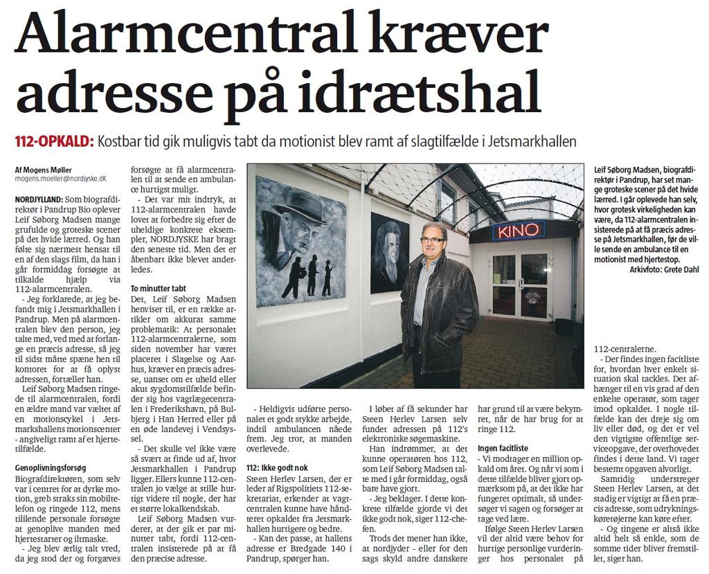
10 Nordjyske
11 Address Program The objective To create a basis for an efficient and consistent reuse of basic data on addresses, place names and administrative units in order to: Form the basis of an effective and coherent e-government Contribute to competitiveness, growth and innovation in the private sector Serve as an unique reference for police and emergency response. 11
12 Address Program The measures The program shall improve the quality and timeliness of the basis data, based on users needs and establish a coherent infrastructure which ensures that data is available in a reliable and efficient way for public and private sector users. 12

13 Address Program so halfway now 13
14 Results & Benefits


15 Administrative units New register for admin. units in operation as from May 2014 Data model according to Danish Modelling Rules for Basic Data and INSPIRE Presently 7 themes available and updated by responsible party; Extra themes will be added in


16 Place Names New place name register in operation as from April 2015 Data model according to Danish Modelling Rules for Basic Data and INSPIRE Presently place names; extra names will be added by other public parties 16


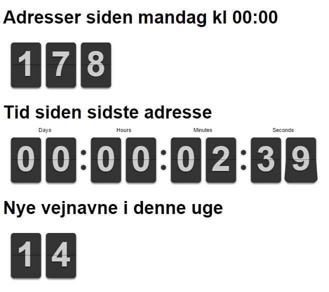
17 Addresses New Address register specified and put out to tender Improvement of address coverage is in progress (areas with few or no addresses) New address services enables open access to current data 17


18 Data model Is compliant with Is easily transformed into DK Modelling Rules for Basic Data INSPIRE Interoperability rules and Data Specification Guidelines For Administrative Units (AU) Administrative unit data model 18


19 Improving Address Coverage 19


20 Improving Address Coverage A significant task estimated to 100 man-years in the municipalities carried out by in and supported by a special addressing task force 20


21 Improved Data Services Auto-complete ; simple input Download data files Map services; WMS / WFS In operation since May 2014 Suite of Open Address Services (AWS 4.0) Replication; Synchronize local copy Reverse geocoding; click in map Full Web API; System-2-System 21
22 Timeliness For e-government, timeliness is essential 22
23 Timelines Time from the recording of an address until it is published in our web services 10 sec. 40 sec. Tomorrow Present result 3-4 min. 1-2 days 20 days 23
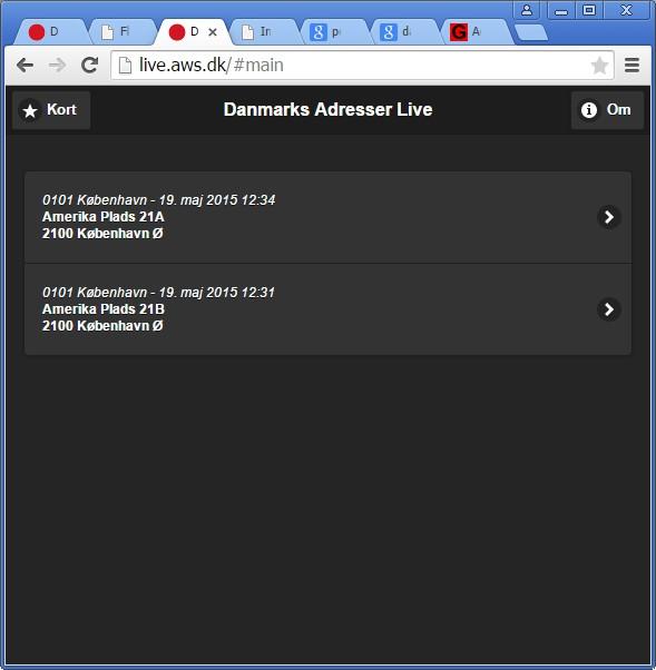
24 Timeliness :33: T 12:34: :34:07 24
25 Results & Benefits
26 Getting the Business Case s Benefits Every new user adds value to the business case 26

27 Statistics After 1st year in service: > 2,5 mill. requests/week > 150 web-applications uses AWS 4.0 Measured mid May


28 Identified users & stakeholders High quality and current address data and services 28

29 Example Quote From Google Maps blog site
30 mill. DKK Getting the Business Case s Benefits 20 Mill. EUR 30
31 Challenges

32 Time to Market It is absolutely essential that the improved data and services are implemented by the industry into new, innovative products, applications and devices. This is Time to Market 32


33 Help me, my SAT-NAV system can not find the way Kent and Sussex Courier, 29. Jan Nordjyske


34 The Value Flow Improved addressing, data and services Public sector Industry incl. innovative start-ups and SME We must also focus here to ensure the best possible implementation and time to market Products, Devices Applications In order to gain the benefits = the fastest possible achievement of the estimated benefits for society Funding Society by large, Citizens, Taxpayers 34

35 The team of program and project managers behind the 35
36 Contact information: Morten Lind, Ministry for Housing, Urban and Rural Affairs Denmark, The Ministry (MBBL): Danish Geodata Agency: Danish Basic Data Program: The Address Program: Danish Address Website: Twitter: Danmarks Adresser Address data services: UPU White Paper: Addressing the World an Address for Everyone : 36
Danmarks Miljøportal The Danish Natural Environment Portal
 Danmarks Miljøportal The Danish Natural Environment Portal 2 Agenda What s The Danish Natural Environment Portal. Short live demo of Danmarks Arealinformation, with special focus on the inspire layers,
Establishing the National Spatial Data Infrastructure (NSDI) for Norway a joint effort by many stakeholders SPATIAL DATA FOR BENEFIT OF THE SOCIETY
 for Norway a joint effort by many stakeholders SPATIAL DATA FOR BENEFIT OF THE SOCIETY") Establishing the National Spatial Data Infrastructure (NSDI) for Norway a joint effort by many stakeholders SPATIAL DATA FOR THE BENEFIT OF SOCIETY OUTLINE Political background Norway digital - The Norwegian
Establishing the National Spatial Data Infrastructure (NSDI) for Norway a joint effort by many stakeholders SPATIAL DATA FOR THE BENEFIT OF SOCIETY OUTLINE Political background Norway digital - The Norwegian
Implementation of Inspire in Denmark - How we get it flying! Olav Eggers National Survey & Cadastre -Denmark
 Implementation of Inspire in Denmark - How we get it flying! Olav Eggers oe@kms.dk National Survey & Cadastre -Denmark Introduction Overview Infrastructure for Spatial Information Act National Survey and
Report on the impact of open geographical data - Danish effect studies -
 Presented at the FIG Congress 2018, May 6-11, 2018 in Istanbul, Turkey Report on the impact of open geographical data - Danish effect studies - (Paper no 9603) Agenda 1. Intro teaser 2. Basic digital infrastructure
Demonstration of a local SDI solution with several stakeholders in pilot areas in line with EU best practices
 EU Twinning project for the Agency of Land Relations and Cadaster (ALRC)- Organization, Streamlining and Computerization Process in Mapping in the Republic of Moldova. Demonstration of a local SDI solution
INSPIRE implementation in the Danish Ministry of the Environment. Environmental data - from onsite collection to compliant INSPIRE distribution
 INSPIRE implementation in the Danish Ministry of the Environment Environmental data - from onsite collection to compliant INSPIRE distribution Welcome to workshop! Danish Ministry of the Environment and
Status of implementation of the INSPIRE Directive 2016 Country Fiches. COUNTRY FICHE Denmark
 Status of implementation of the INSPIRE Directive 2016 Country Fiches COUNTRY FICHE Denmark Introduction... 1 1. State of Play... 2 1.1 Coordination... 2 1.2 Functioning and coordination of the infrastructure...
Open spatial data infrastructure
 Open spatial data infrastructure a backbone for digital government Thorben Hansen Geomatikkdagene 2018 Stavanger 13.-15. mars Spatial Data Infrastructure definition the technology, policies, standards,
Building a national spatial data infrastructure. Thorben Hansen, Head of Division Danish Agency for Data Supply and Efficiency
 Building a national spatial data infrastructure Thorben Hansen, Head of Division Danish Agency for Data Supply and Efficiency About Spatial Data Infrastructure Spatial data come from many sources and is
Status of implementation of the INSPIRE Directive 2016 Country Fiches. COUNTRY FICHE France
 Status of implementation of the INSPIRE Directive 2016 Country Fiches COUNTRY FICHE France Introduction... 1 1. State of Play... 2 1.1 Coordination... 2 1.2 Functioning and coordination of the infrastructure...
Maanmittauspäivät 2018 Helsinki Maanmittauspäivät 2018 The Danish initiatives regarding open and free basic data including effect studies
 Maanmittauspäivät 2018 The Danish initiatives regarding open and free basic data including effect studies 22.03.2018 Agenda 1. Intro overall frame / selfie 2. Data Infrastructure 3. The Danish Digital
Status of implementation of the INSPIRE Directive 2016 Country Fiches. COUNTRY FICHE Estonia
 Status of implementation of the INSPIRE Directive 2016 Country Fiches COUNTRY FICHE Estonia Introduction... 1 1. State of Play... 2 1.1 Coordination... 2 1.2 Functioning and coordination of the infrastructure...
E-Government and SDI in Bavaria, Germany
 135 E-Government and SDI in Bavaria, Germany Wolfgang STOESSEL, Germany Key words: GDI-BY, Bavaria, Spatial Data Infrastructure SUMMARY Spatial Data Infrastructure (SDI) is an important part of the e-government
Between legislation and consensus how do we INSPIRE Denmark?
 Between legislation and consensus how do we INSPIRE Denmark? Olav Eggers Spatial Data Infrastructure Division Danish Ministry of the Environment National Survey and Cadastre (KMS), Denmark INSPIRE Contact
The state-of-the-art of the Finnish SDI. Arctic SDI WG Meeting
 The state-of-the-art of the Finnish SDI Arctic SDI WG Meeting Moscow 8.9.2011 Esa Tiainen Development Centre 1 NATIONAL LAND SURVEY DOWN TO EARTH Contents Legal framework Coordination structure Network
INSPIREd solutions for Air Quality problems Alexander Kotsev
 INSPIREd solutions for Air Quality problems Alexander Kotsev www.jrc.ec.europa.eu Serving society Stimulating innovation Supporting legislation The European data puzzle The European data puzzle 24 official
INSPIRE - A Legal framework for environmental and land administration data in Europe
 INSPIRE - A Legal framework for environmental and land administration data in Europe Dr. Markus Seifert Bavarian Administration for Surveying and Cadastre Head of the SDI Office Bavaria Delegate of Germany
Turkey s National SDI Implementation
 Onur PAŞAOĞULLARI Head of Department Turkey s National SDI Implementation Presentation Plan NSDI Background General Directorate of Geographic Information Systems NSDI Project INSPIRE Directive Urban Information
Status of implementation of the INSPIRE Directive 2016 Country Fiches. COUNTRY FICHE Finland
 Status of implementation of the INSPIRE Directive 2016 Country Fiches COUNTRY FICHE Finland Introduction... 1 1. State of Play... 2 1.1 Coordination... 2 1.2 Functioning and coordination of the infrastructure...
Quality information for the Digital Agenda EuroGeographics contribution to the Digital Agenda for Europe
 Quality information for the Digital Agenda EuroGeographics contribution to the Digital Agenda for Europe Ingrid Vanden Berghe, EuroGeographics President high performance infrastructure quality contentinformation
Status of implementation of the INSPIRE Directive 2016 Country Fiches. COUNTRY FICHE Czech Republic
 Status of implementation of the INSPIRE Directive 2016 Country Fiches COUNTRY FICHE Czech Republic Introduction... 1 1. State of Play... 2 1.1 Coordination... 2 1.2 Functioning and coordination of the
Member State Report: Denmark
 INSPIRE Infrastructure for Spatial Information in Europe Member State Report: Denmark 2010-2012 Title Member State Report: Denmark 2010-2012 Creator Lars Erik Storgaard (national reporter) and Marie Holm
Norwegian spatial data infrastructure supporting disaster risk management Norwegian Mapping Authority
 Norwegian spatial data infrastructure supporting disaster risk management Norwegian Mapping Authority Arvid Lillethun, Norwegian Mapping Authority Land and Poverty 2018 Conference, World Bank 19.-23. March
Jeroen Hogeboom. Advisor Information Management PDOK Kadaster (Cadastre, Land Registry, Mapping Agency of NL) Introduction
 Introduction") Jeroen Hogeboom Advisor Information Management PDOK Kadaster (Cadastre, Land Registry, Mapping Agency of NL) Introduction Outline About PDOK Data processing Architecture Using PDOK Statistics Monitoring
Jeroen Hogeboom Advisor Information Management PDOK Kadaster (Cadastre, Land Registry, Mapping Agency of NL) Introduction Outline About PDOK Data processing Architecture Using PDOK Statistics Monitoring
Emerging Trends in Institutional Arrangements Europe - Finland
 Emerging Trends in Institutional Arrangements Europe - Finland Arvo Kokkonen Deputy Director General National Land Survey of Finland 1 Contents Facts about Finland National Land Survey of Finland European
Global Geospatial Information Management Country Report Finland. Submitted by Director General Jarmo Ratia, National Land Survey
 Global Geospatial Information Management Country Report Finland Submitted by Director General Jarmo Ratia, National Land Survey Global Geospatial Information Management Country Report Finland Background
The value of open geographical. Geospatial World Forum, Geneva 9 th May, 2014 Open data session Tina Svan Colding, The Danish Geodata Agency
 The value of open geographical data the Danish case Geospatial World Forum, Geneva 9 th May, 2014 Open data session Tina Svan Colding, The Danish Geodata Agency Danish Geodata Agency Basic public data
Welcome to GST. Visit from Bhutan June 3rd Pia Dahl Højgaard, Manager, Maintenance-Properties
 Welcome to GST Visit from Bhutan June 3rd 2013 Pia Dahl Højgaard, Manager, Maintenance-Properties About the Danish Geodata Agency The Danish Geodata Agency (Geodatastyrelsen) ensures that geographical
INSPIRE General Introduction & Service Architecture
 INSPIRATION Spatial Data Infrastructure in the Western Balkans INSPIRE General Introduction & Service Architecture 1st National INSPIRATION Workshop Croatia November 21-22, 2012 A multi-countryprojectfunded
ArcGIS for INSPIRE. Marten Hogeweg
 ArcGIS for INSPIRE Marten Hogeweg Please Take Our Survey on the App Download the Esri Events app and find your event Select the session you attended Scroll down to find the feedback section Complete answers
ArcGIS for INSPIRE. Paul Hardy. ArcGIS. ArcGIS for INSPIRE Enables Esri ArcGIS users to implement and comply with INSPIRE. INSPIRE Data Themes
 Enables Esri ArcGIS users to implement and comply with INSPIRE Paul Hardy phardy@esri.com EuroGeographics INSPIRE KEN (Schema Transformation) 8/9 October 2013, Marne la Vallée INSPIRE Data Themes Annex
Development of a Dainish infrastructure for spatial information (DAISI) Brande-Lavridsen, Hanne; Jensen, Bent Hulegaard
 Brande-Lavridsen, Hanne; Jensen, Bent Hulegaard") Aalborg Universitet Development of a Dainish infrastructure for spatial information (DAISI) Brande-Lavridsen, Hanne; Jensen, Bent Hulegaard Published in: NORDGI : Nordic Geographic Information Publication
Aalborg Universitet Development of a Dainish infrastructure for spatial information (DAISI) Brande-Lavridsen, Hanne; Jensen, Bent Hulegaard Published in: NORDGI : Nordic Geographic Information Publication
ELF- Providing Platforms for Accessing INSPIRE Based Reference Data
 ELF- Providing Platforms for Accessing INSPIRE Based Reference Data Presentation to: By: Date: General Antti Jakobsson 11 th Sept 2015 15 September, 2015 Why ELF? Crowdsourcing Authoritysourcing = ELF
INSPIRATION results and benefits for the Agency for Real Estate Cadastre
 JOINT RESEARCH CENTER - E&I WORKSHOP INSPIRATION results and benefits for the Agency for Real Estate Cadastre Sonja Dimova, state advisor AGENCY FOR REAL ESTATE CADASTRE REPUBLIC OF MACEDONIA Wednesday,
INSPIRE Monitoring and Reporting Implementing Rule Draft v2.1
 INSPIRE Infrastructure for Spatial Information in Europe INSPIRE Monitoring and Reporting Implementing Rule Draft v2.1 Title INSPIRE Monitoring and Reporting Implementing Rule v2.1 Creator DT Monitoring
Status of implementation of the INSPIRE Directive 2016 Country Fiches. COUNTRY FICHE Ireland
 Status of implementation of the INSPIRE Directive 2016 Country Fiches COUNTRY FICHE Ireland Introduction... 1 1. State of Play... 2 1.1 Coordination... 2 1.2 Functioning and coordination of the infrastructure...
Technical Framework Methodology as a core of building up the NSDI NSDI Implementation Specifics in Serbia
 Technical Framework Methodology as a core of building up the NSDI NSDI Implementation Specifics in Serbia Luka Jovičić SDI Consultant@ Gramont Ltd. Aleksandar Dedić RGA NSDI department Dragica Pajić RGA
Status of implementation of the INSPIRE Directive 2016 Country Fiches. COUNTRY FICHE Croatia
 Status of implementation of the INSPIRE Directive 2016 Country Fiches COUNTRY FICHE Croatia Introduction... 1 1. State of Play... 2 1.1 Coordination... 2 1.2 Functioning and coordination of the infrastructure...
Indsæt billede her. Location an INSPIRED gateway to E-government
 Location an INSPIRED gateway to E-government Indsæt billede her Ulla Kronborg Mazzoli INSPIRE contact point Deputy Chief Spatial Data Infrastructure Danish National Survey and Cadastre Outline A short
a national geological survey perspective François ROBIDA BRGM (French Geological Survey)
") a national geological survey perspective François ROBIDA BRGM (French Geological Survey) Pre-Conference Seminar on Socio-Economic Value of Geospatial for National and Regional Development 21 August 2017,
a national geological survey perspective François ROBIDA BRGM (French Geological Survey) Pre-Conference Seminar on Socio-Economic Value of Geospatial for National and Regional Development 21 August 2017,
The Swedish National Geodata Strategy and the Geodata Project
 The Swedish National Geodata Strategy and the Geodata Project Ewa Rannestig, Head of NSDI Co-ordination Unit, Lantmäteriet, ewa.rannstig@lm.se Ulf Sandgren, Project Manager Geodata Project, Lantmäteriet,
Status of implementation of the INSPIRE Directive 2016 Country Fiches. COUNTRY FICHE Netherlands
 Status of implementation of the INSPIRE Directive 2016 Country Fiches COUNTRY FICHE Netherlands Introduction... 1 1. State of Play... 2 1.1 Coordination... 2 1.2 Functioning and coordination of the infrastructure...
The impact of the open geographical data follow up study Agency for Data Supply and Efficiency
 www.pwc.dk The impact of the open geographical data follow up study Agency for Data Supply and Efficiency March 17th 2017 Management summary In recent years, interest in releasing public-sector data has
The challenge of linking or integrating data on Buildings
 The challenge of linking or integrating data on Buildings Expected benefits: user requirements Wide use of data on Buildings Buildings are places where people live, work, spend more of their time => Data
European Location Framework data in the ArcGIS platform
 European Location Framework data in the ArcGIS platform Presentation to: Author: Date: INSPIRE Conference 2016 Clemens Portele 26 September 2016 Why ELF? Global (e.g. UN GGIM) Regional Europe (INSPIRE
INSPIRE implementation in the Turkish Ministry of Environment and Urbanization Producing and Publishing Environmental Data
 INSPIRE implementation in the Turkish Ministry of Environment and Urbanization Producing and Publishing Environmental Data Ezgi Sarmusak Urban Planner, MoEU Sibel Süer Toybıyık - Assistant Expert, MoEU
Analys av GIS-användning inom offentlig sektor i Norden
 Analys av GIS-användning inom offentlig sektor i Norden Henning Sten Hansen, Line Hvingel and Lise Schrøder Aalborg Universitet Jönköping, Sweden 30 March 2011 Overview The Danish and Swedish approaches
GIS Geographical Information Systems. GIS Management
 GIS Geographical Information Systems GIS Management Difficulties on establishing a GIS Funding GIS Determining Project Standards Data Gathering Map Development Recruiting GIS Professionals Educating Staff
Spatial Data Infrastructure Concepts and Components. Douglas Nebert U.S. Federal Geographic Data Committee Secretariat
 Spatial Data Infrastructure Concepts and Components Douglas Nebert U.S. Federal Geographic Data Committee Secretariat August 2009 What is a Spatial Data Infrastructure (SDI)? The SDI provides a basis for
Ministry of ICT of I.R.IRAN
 The ECO 8/6 mill km 2 10 Slamic countries ~330 mill people Oil, Gas, Industries,Tourism 2 Issue transformation in last decade Problem solving needs more integrated approach More interaction &complexity
Grant Agreement No. EIE/07/595/SI BEn
 Biomass energy register for sustainable site development for European regions Grant Agreement No. EIE/07/595/SI2.499697 BEn Biomass energy register for sustainable site development for European regions
EuroGeographics & INSPIRE. Nick Land, Executive Director of EuroGeographics
 EuroGeographics & INSPIRE Nick Land, Executive Director of EuroGeographics EuroGeographics A growing association 49 Members, 42 countries Topographic mapping, cadastre, land registry + Networked organisation
ArcGIS Earth for Enterprises DARRON PUSTAM ARCGIS EARTH CHRIS ANDREWS 3D
 ArcGIS Earth for Enterprises DARRON PUSTAM ARCGIS EARTH CHRIS ANDREWS 3D ArcGIS Earth is ArcGIS Earth is a lightweight globe desktop application that helps you explore any part of the world and investigate
econtentplus GS Soil
 econtentplus GS Soil General aims Assessment and strategic development of INSPIRE compliant Geodata-Services for European Soil Data BPN on basis of the EU 2007/2/EC (INSPIRE) Directive for Annex III theme
Status of implementation of the INSPIRE Directive 2016 Country Fiches. COUNTRY FICHE Malta
 Status of implementation of the INSPIRE Directive 2016 Country Fiches COUNTRY FICHE Malta Introduction... 1 1. State of Play... 2 1.1 Coordination... 2 1.2 Functioning and coordination of the infrastructure...
SWEDISH SDI DEVELOPMENT & IMPLEMENTATION OF INSPIRE
 SWEDISH SDI DEVELOPMENT & IMPLEMENTATION OF INSPIRE Christina Wasström, Lantmäteriet, 801 82 Gävle, Sweden, christina.wasstrom@lm.se ABSTRACT The Swedish Government and Parliament has given Lantmäteriet
SITMUN: Cooperating to Build Local SDIs in the Barcelona Region
 SITMUN: Cooperating to Build Local SDIs in the Barcelona Region Diputació de Barcelona Territory and Sustainability Area Territorial Information Systems Department INSPIRE CONFERENCE Barcelona, September
Implementing the Smart Growth Priority in an Open and Interoperable System for Geographic Data: Sardinia SITR- IDT
 REGION OF SARDINIA (ITALY) LOCAL AUTHORITY FOR MUNICIPALITIES, FINANCES AND URBAN PLANNING DEPT. FOR THE REGIONAL SPATIAL DATA INFRASTRUCTURE Implementing the Smart Growth Priority in an Open and Interoperable
Marine Spatial Planning, a Norwegian user case NSHC33
 Marine Spatial Planning, a Norwegian user case NSHC33 Marine Spatial Management Tool Support the marine spatial planning process with updated and reliable geospatial information Marine management is important
The Process of Spatial Data Harmonization in Italy. Geom. Paola Ronzino
 The Process of Spatial Data Harmonization in Italy Geom. Paola Ronzino ISSUES Geospatial Information in Europe: lack of data harmonization the lack of data duplication of data CHALLENGES Challenge of INSPIRE:
Solving the European Data Puzzle Simplifying INSPIRE Challenges and Usage. con terra GmbH Dipl.-Ing. Mark Döring
 Solving the European Data Puzzle Simplifying INSPIRE Challenges and Usage con terra GmbH Dipl.-Ing. Mark Döring INSPIRE Reference Projects GeoBAK 2.0 Project // INSPIRE Data & Services The Project Evolution
ELF products in the ArcGIS platform
 ELF products in the ArcGIS platform Presentation to: Author: Date: NMO Summit 2016, Dublin, Ireland Clemens Portele 18 May 2016 The Building Blocks 18 May, 2016 More ELF users through affiliated platforms
AN OVERVIEW OF SPATIAL DATA INFRASTRUCTURE OF TURKEY WITH A VIEW TO COMPLYING WITH INSPIRE STANDARDS
 AN OVERVIEW OF SPATIAL DATA INFRASTRUCTURE OF TURKEY WITH A VIEW TO COMPLYING WITH INSPIRE STANDARDS Ebru Alarslan Halil Söğüt OUTLINE A Brief History of SDI in Turkey Milestones in the History of SDI
Status of implementation of the INSPIRE Directive 2016 Country Fiches. COUNTRY FICHE Portugal
 Status of implementation of the INSPIRE Directive 2016 Country Fiches COUNTRY FICHE Portugal Introduction... 1 1. State of Play... 2 1.1 Coordination... 2 1.2 Functioning and coordination of the infrastructure...
The road to national Inspire-compliant datasets in the Czech republic
 The road to national Inspire-compliant datasets in the Czech republic Ing. Pavel Šidlichovský (Land Survey Office of Czech Republic) INSPIRE 2014; 18.6. Aalborg Overview Directive transposition COSMC and
Open geographical data the Danish case. GeoInfo 2014 Tina Svan Colding, The Danish Geodata Agency
 Open geographical data the Danish case GeoInfo 2014 Tina Svan Colding, The Danish Geodata Agency Danish Geodata Agency Basic public data Danish Geodata Agency PAGE 3 The Agreement PAGE 7 Content Danish
INSPIRE Directive. Status June 2007
 INSPIRE Directive INfrastructure for SPatial InfoRmation in Europe Status June 2007 European Commission Directorate-General Environment Research, Science and Innovation Unit Rue de la Loi, 200 1049 Brussels
Status of implementation of the INSPIRE Directive 2016 Country Fiches. COUNTRY FICHE Italy
 Status of implementation of the INSPIRE Directive 2016 Country Fiches COUNTRY FICHE Italy Introduction... 1 1. State of Play... 2 1.1 Coordination... 2 1.2 Functioning and coordination of the infrastructure...
ESDIN Results from a Crossborder INSPIRE Preparatory Project. Jörgen Hartnor, Lantmäteriet.
 ESDIN Results from a Crossborder INSPIRE Preparatory Project Jörgen Hartnor, Lantmäteriet www.esdin.eu Ett econtentplus Best Practice Network projekt September 2008 February 2011 Coordinated by EuroGeographics
State initiative following up the 2006 national planning report
 18 ness districts and public institutions, should be integrated with the opportunities for public transport services. State initiative following up the 2006 national planning report The Ministry of the
The European Location Framework (ELF) Project One Source for Reference Geo-Information for Europe
 Project One Source for Reference Geo-Information for Europe") The European Location Framework (ELF) Project One Source for Reference Geo-Information for Europe Presentation to: By: Date: INSPIRE Conference Antti Jakobsson, Technical Coordinator 25 th June 2013 25
The European Location Framework (ELF) Project One Source for Reference Geo-Information for Europe Presentation to: By: Date: INSPIRE Conference Antti Jakobsson, Technical Coordinator 25 th June 2013 25
Swedish Spatial Data Infrastructure and the National Geodata Strategy
 Submitted to the United Nations Committee of Experts on Global Geospatial Information Management Seventh Session New York, August 2018 Registration number 519-2018/4327 Country Report, Sweden Swedish Spatial
SDI Development in Georgia. Mari Khardziani Head of International Relations Unit National Agency of Public Registry
 SDI Development in Georgia Mari Khardziani Head of International Relations Unit National Agency of Public Registry Kehl, Germany September 5, 2017 2 National Agency of Public Registry Legal Entity of Public
Innovation in Land Management: Integrated Solutions For National Cadastre Projects
 Success With GIS Innovation in Land Management: Integrated Solutions For National Cadastre Projects XXIII International FIG Congress Munich These documents are only complete, when used in connection with
Spatial Statistical Information Services in KOSTAT
 Distr. GENERAL WP.30 12 April 2010 ENGLISH ONLY UNITED NATIONS ECONOMIC COMMISSION FOR EUROPE (UNECE) CONFERENCE OF EUROPEAN STATISTICIANS EUROPEAN COMMISSION STATISTICAL OFFICE OF THE EUROPEAN UNION (EUROSTAT)
Land Board, NW Services and SDI Tambet Tiits, FRICS
 Land Board, NW Services and SDI Tambet Tiits, FRICS 07.09.2016 200th anniversary of the Struve Geodetic Arc Friedrich Georg Wilhelm Struve and Carl Friedrich Tenner Struve Geodetic Arc The Struve Geodetic
SITR-IDT The Spatial Data Infrastructure of Sardinia Region
 ITALY LOCAL AUTHORITY FOR MUNICIPALITIES, FINANCES AND URBAN PLANNING REGIONAL DEPARTMENT FOR CARTOGRAPHY AND INFORMATION SYSTEMS SITR-IDT The Spatial Data Infrastructure of Sardinia Region Content of
Infrastructure for Spatial Information in Europe (INSPIRE)
") Infrastructure for Spatial Information in Europe (INSPIRE) 2011 GISCO Working Party 8-9.3.2012 INSPIRE is about improving access to spatial information: the environment doesn t stop at borders EU Geoportal
Infrastructure for Spatial Information in Europe (INSPIRE) 2011 GISCO Working Party 8-9.3.2012 INSPIRE is about improving access to spatial information: the environment doesn t stop at borders EU Geoportal
INSPIRE Thematic Cluster on Topographic and Cadastral Reference data
 INSPIRE Thematic Cluster on Topographic and Cadastral Reference data Anja Hopfstock - facilitator www.jrc.ec.europa.eu Serving society Stimulating innovation Supporting legislation Status of Thematic cluster
Using OGC standards to improve the common
 Using OGC standards to improve the common operational picture Abstract A "Common Operational Picture", or a, is a single identical display of relevant operational information shared by many users. The
TheEuropean Location Framework
 TheEuropean Location Framework Presentation to: Author: Date: TN-ITS/INSPIRE session at INSPIRE Conference Olaf Magnus Østensen, ELF co-ordinator 18 June2014 The ELF project 15 national mapping authorities
Think Local - Act Global a Nordic Perspective
 Think Local - Act Global a Nordic Perspective OGC Nordic Forum Jari Reini 20-21.5.2014 OGC Nordic Forum? OGC Nordic Forum addresses OGC outreach and education needs of government, academic, research and
Project based approach developing National Spatial Data Infrastructure in Lithuania
 Project based approach developing National Spatial Data Infrastructure in Lithuania National Land Service under the Ministry of Agriculture of The Republic of Lithuania Cadastres & Geodesy Department Director
Henning Sten Hansen, Line Hvingel & Lise Schrøder (AAU) Jesper Høi Skovdal (Geoforum Denmark) LISE SCHRØDER AALBORG UNIVERSITY
 Jesper Høi Skovdal (Geoforum Denmark) LISE SCHRØDER AALBORG UNIVERSITY") Henning Sten Hansen, Line Hvingel & Lise Schrøder (AAU) Jesper Høi Skovdal (Geoforum Denmark) Presentation overview Background Nordic surveys The way forward Concluding remarks Transforming government
Henning Sten Hansen, Line Hvingel & Lise Schrøder (AAU) Jesper Høi Skovdal (Geoforum Denmark) Presentation overview Background Nordic surveys The way forward Concluding remarks Transforming government
Basic Data & Model Rules. Flemming Nissen, The Danish Geodata Agency
 Basic Data & Model Rules Flemming Nissen, The Danish Geodata Agency Disposition On egovernment Strategy On the Basic Data Programme The Danish Geodata Agency data for Properties, Place Names and Adm. Units
SDI-Challenges European perspective
 THE HIGH LEVEL FORUM ON GLOBAL GEOSPATIAL INFORMATION MANAGEMENT Seoul, Republic of Korea, 24-26 October 2011 Session 1: Challenges in geospatial policy formation and institutional arrangements SDI-Challenges
PLR activities in Denmark. Vibeke Stærdahl Nielsen
 PLR activities in Denmark Vibeke Stærdahl Nielsen Public-Law restrictions (PLRs) in several registers and systems Cadastre The Land Register The Danish Natural Environment Portal DKjord PlansystemDK.(www.ois.dk,
Implementing INSPIRE in Sweden
 Implementing INSPIRE in Sweden Christina Wasström NSDI-unit, Lantmäteriet Christina.wasstrom@lm.se Standards Cooperation Metadata Competence Infrastructure for Geodata Legal Framework Portal Services Geodata
SPANISH GOOD (AND NO SO GOOD) PRACTICES IMPLEMENTING INSPIRE
 PRACTICES IMPLEMENTING INSPIRE") SPANISH GOOD (AND NO SO GOOD) PRACTICES IMPLEMENTING INSPIRE HELLO! I am Emilio López I am here because I am the Director of the National Centre for Geographic Information You can find me at elromero@fomento.es
SPANISH GOOD (AND NO SO GOOD) PRACTICES IMPLEMENTING INSPIRE HELLO! I am Emilio López I am here because I am the Director of the National Centre for Geographic Information You can find me at elromero@fomento.es
GIS Building Communities beyond National Borders (Building Successful Spatial Data Infrastructures) Nick Land, ESRI Europe
 Nick Land, ESRI Europe") GIS Building Communities beyond National Borders (Building Successful Spatial Data Infrastructures) Nick Land, ESRI Europe UK worst flooding in the last 60 years 350,000 households without drinking water
GIS Building Communities beyond National Borders (Building Successful Spatial Data Infrastructures) Nick Land, ESRI Europe UK worst flooding in the last 60 years 350,000 households without drinking water
INSPIRing Geospatial Framework For Local Administrations
 This project is financed by the European Union and the Republic of Turkey Presented at the FIG Congress 2018, May 6-11, 2018 in Istanbul, Turkey National Programme for Turkey 2010 Instrument for Pre-Accession
Support to Statistics. Kosovo
 TWINNING CONTRACT Support to Statistics Kosovo MISSION REPORT on Visualization of statistics using GIS software Component no 4.3.2 Mission carried out by Troels Aksel Vestergaard, Statistics Denmark 18-20
Estonian approach to implementation of INSPIRE directive. Sulev Õitspuu Head of Bureau of Geoinfosystems Estonian Land Board
 Estonian approach to implementation of INSPIRE directive Sulev Õitspuu Head of Bureau of Geoinfosystems Estonian Land Board 13.06.2016 Contents - INSPIRE coordination in Estonia - INSPIRE implementation
Discovery and Access of Geospatial Resources using the Geoportal Extension. Marten Hogeweg Geoportal Extension Product Manager
 Discovery and Access of Geospatial Resources using the Geoportal Extension Marten Hogeweg Geoportal Extension Product Manager DISCOVERY AND ACCESS USING THE GEOPORTAL EXTENSION Geospatial Data Is Very
Exploring GIS Potential for Northwestern Ontario Land Information Ontario
 Exploring GIS Potential for Northwestern Ontario Land Information Ontario May 13, 2015 The LIO Vision LIO Vision: That all geographic information about Ontario is fully integrated and accessible LIO Goal:
Zagreb Spatial Data Infrastructure. Sanja Batić, APIS IT Split, 14. rujna 2011.
 Zagreb Spatial Data Infrastructure Sanja Batić, APIS IT Split, 14. rujna 2011. Agenda Zagreb Spatial Data Infrastructure - ZIPP Guidelines for further ZIPP Geoportal development Conclusion 1964 The Centre
Nordic Address Forum. Cooperation with Municipalities & The Geodata Strategy. Angela Fessé Lantmäteriet Odense, June
 Nordic Address Forum Cooperation with Municipalities & The Geodata Strategy Angela Fessé Lantmäteriet Odense, June 3-4 2010 Why collaborate on national databases? The private market and society have broader
Implementing INSPIRE Geoportal in Turkey
 Implementing INSPIRE Geoportal in Turkey Gencay SERTER City and Regional Planner 1 Presentation Plan Introduction INSPIRE and Turkey Importance of al Spatial Planning Portal Logical&Legal Hierarchy GeoPortal
Implementation of INSPIRE Principles: Sardinia Region SDI State of the Art and Further Developments
 REGION OF SARDINIA (ITALY) LOCAL AUTHORITY FOR MUNICIPALITIES, FINANCES AND URBAN PLANNING DEPT. FOR THE REGIONAL SPATIAL DATA INFRASTRUCTURE Implementation of INSPIRE Principles: Sardinia Region SDI State
The importance of persistent URIs for the implementation of INSPIRE
 The importance of persistent URIs for the implementation of INSPIRE INSPIRE Conference 2012, Istanbul Clemens Portele, interactive instruments GmbH Drafting Team Data Specifications (Chair) Directive,