Geo-historical Data EuroSDR Historical Data seminar 2014/10/17
|
|
|
- Jemimah Bishop
- 5 years ago
- Views:
Transcription
1 Geo-historical Data EuroSDR Historical Data seminar 2014/10/17 Marc Barthelemy Benoît Costes Bertrand Dumenieu Maurizio Gribaudi Julien Perret
2 Collaborations Several french projects GeOpenSim (LSIIT, LIVE) - ANR GéoPeuple (EHESS, LIP6) - ANR Collaboration with EHESS PhD Theses Bertrand Dumenieu ( ) Benoît Costes ( ) Collaboration with EHESS, CEA, IFSTTAR, ArScAn, BnF... GeoHistoricalData (started in 2013) lead by EHESS, IGN, CEA IGN, EHESS, CEA, IFSTTAR, ArScAn, Géographie-Cités, BnF, INRA, LIVE, Théma, Charta SRL, Le Ny conseil, geospective, NYPL, Stanford
3 Context Increasingly available data Increasingly performant tools georeferencing, digitizing, analyzing, etc. A persistent need and little sharing larger scale more diverse Collaborative approaches bring solutions shared data and shared digitizing effort shared tools Reproducible research


![DYNAMICS [Gribaudi09] : Transformations](/docs-images/96/128302342/images/4-2.jpg "spatiales et sociales dans un îlot parisien du")
4 Challenges Understanding urban development = to study the spatial and social organisations of cities though time Feedback loop between phenomena URBAN MORPHOGENESIS TIME SOCIAL DYNAMICS [Gribaudi09] : Transformations spatiales et sociales dans un îlot parisien du XVIIIe au XXe siècles
5 Challenges Dynamic phenomena must be studied over the long term TIME No adapted tool to build databases adapted for the study of urban dynamics for the quantitative analysis of linked phenomena URBAN MORPHOGENESIS SOCIAL DYNAMICS
6 Goals Construction of geo-historical databases data structures imperfection modeling data management Analysis of geo-historical data data matching information fusion transformation analysis
7 Overview 1. Context and challenges 2. Collaborative database construction 3. Spatio-Temporal graphs construction 4. Multi-temporal analysis 5. Conclusion
8 Collaborative construction GeoHistoricalData project lead by Marc Barthelemy, Maurizio Gribaudi and Julien Perret Different sources France Paris Cassini (18th) État Major (19th) Verniquet, Jacoubet, Maire, Poubelle, etc. (18th+19th)

9 Collaborative construction Example on Cassini maps WM(T)S from the géoportail PostgreSQL/PostGIS database QGIS for the digitizing
10 Collaborative construction
11 Collaborative construction
12 Collaborative construction
13 Collaborative construction

14 Collaborative construction
15 Collaborative construction
16 Collaborative construction
17 Collaborative construction
18 Collaborative construction
19 Collaborative construction
20 Collaborative construction
21 Collaborative construction
22 Collaborative construction
23 Collaborative construction
24 Collaborative construction
 starting next week Process for socio-professional data (text) almanacs, etc.")
25 Collaborative construction Towards a collaborative data validation with NYPL Labs (buildinginspector, etc.) starting next week Process for socio-professional data (text) almanacs, etc. with EPITA (Scribo) soon Releases Open Data Free Software
26 Overview 1. Context and challenges 2. Collaborative database construction 3. Spatio-Temporal graphs construction 4. Multi-temporal analysis 5. Conclusion

27 Spatio-Temporal Graphs Applied to PARIS Available spatial sources city maps Complex sources imprecise uncertain incomplete Construction of Spatio-temporal Graphs Bertrand Dumenieu s PhD Thesis
28 Spatio-Temporal Graphs Georeferencing Digitizing Fuzzy temporalisation Multi-source matching Map A ST Graph Map B Map C

29 Spatio-Temporal Graphs

30 Spatio-Temporal Graphs Optimizing the likelihood of the links temporal, geometrical, semantic Multi-Goal optimisation problem Multi-Goal Simulated Annealing [Suppapitnarm 2000] Simple Criteria: temporal antecedence, shape similarity, phonetic similarity
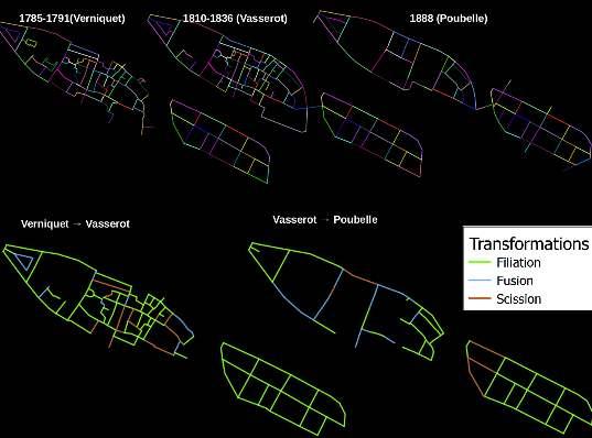
31 Spatio-Temporal Graphs
32 Overview 1. Context and challenges 2. Collaborative database construction 3. Spatio-Temporal graphs construction 4. Multi-temporal analysis 5. Conclusion


33 Multi-temporal Analysis Benoît Costes PhD Thesis morphological analysis of networks betweenness centrality


 Structural")
34 Multi-temporal Analysis Morphogenetic analysis evolution dynamics Spatio-Temporal Aggregated Graphs (TAG) Structural analysis together with dynamics analysis Easy to query

35 Multi-temporal Analysis Links between social data and networks around 1830
36 Overview 1. Context and challenges 2. Collaborative database construction 3. Spatio-Temporal graphs construction 4. Multi-temporal analysis 5. Conclusion
37 Conclusion Important challenges towards a free platform based on free softwares georefencing and digitizing sharing analyzing geo-historical data Difficulties data and hypotheses management imperfections management for data integration, matching and spatio-temporal graph construction for diachronic analysis


38 Thank you!
Structural Segregation: Assessing the impact of South African Apartheid on Underlying Dynamics of Interactions between Networks and Territories
 Structural Segregation: Assessing the impact of South African Apartheid on Underlying Dynamics of Interactions between Networks and Territories J. Raimbault 1,2, and S. Baffi 1,3 juste.raimbault@polytechnique.edu
The French SIGMA-Cassini Research Group The Agenda for
 Page 1 of 9 The French SIGMA-Cassini Research Group The Agenda for 2005-2008 M. Mainguenaud C. Weber michel.mainguenaud@insa-rouen.fr christiane.weber@lorraine.u-strasbg.fr http://www.sigma-cassini.org
MIXING, BLENDING, MERGING OR SCRAMBLING TOPOGRAPHIC MAPS AND ORTHOIMAGERY IN GEOVISUALIZATION?
 MIXING, BLENDING, MERGING OR SCRAMBLING TOPOGRAPHIC MAPS AND ORTHOIMAGERY IN GEOVISUALIZATION? Charlotte Hoarau, Sidonie Christophe, Sébastien Mustière International Cartographic Conference (ICC) - Tuesday,
Introducing the WISERD Geoportal. WISERD DATA TEAM Dr Robert Berry & Dr Richard Fry, University of Glamorgan Dr Scott Orford, Cardiff University
 Introducing the WISERD Geoportal WISERD DATA TEAM Dr Robert Berry & Dr Richard Fry, University of Glamorgan Dr Scott Orford, Cardiff University WISERD What is WISERD? Wales Institute of Social and Economic
Multiscale Spatio-Temporal Data Aggregation and Mapping for Urban Data Exploration
 Multiscale Spatio-Temporal Data Aggregation and Mapping for Urban Data Exploration Etienne Co me1 and Anaı s Remy2 1- Universite Paris-Est, COSYS, GRETTIA, IFSTTAR, F-77447 Marne-la-Valle e, France 2-
Assessing pervasive user-generated content to describe tourist dynamics
 Assessing pervasive user-generated content to describe tourist dynamics Fabien Girardin, Josep Blat Universitat Pompeu Fabra, Barcelona, Spain {Fabien.Girardin, Josep.Blat}@upf.edu Abstract. In recent
The SyMoGIH project and Geo-Larhra: A method and a collaborative platform for a digital historical atlas
 The SyMoGIH project and Geo-Larhra: A method and a collaborative platform for a digital historical atlas Francesco Beretta, Claire-Charlotte Butez To cite this version: Francesco Beretta, Claire-Charlotte
INTRODUCTION. In March 1998, the tender for project CT.98.EP.04 was awarded to the Department of Medicines Management, Keele University, UK.
 INTRODUCTION In many areas of Europe patterns of drug use are changing. The mechanisms of diffusion are diverse: introduction of new practices by new users, tourism and migration, cross-border contact,
Juste Raimbault 1. Abstract
 Plurimondi, xx, 2016 xx-xx Models Coupling Urban Growth and Transportation Network Growth : An Algorithmic Systematic Review Approach Juste Raimbault 1 xx Abstract A broad bibliographical study suggests
A Spatial Data Infrastructure dedicated to scientific research and observation of the coastal environment
 A Spatial Data Infrastructure dedicated to scientific research and observation of the coastal environment http://indigeo.fr Mathias ROUAN - Research Engineer - UMR 6554 LETG CNRS Littoral, Environment,
COMPREHENSIVE LAND-USE MANAGEMENT UNDERSTANDING THE INTERRELATIONSHIP BETWEEN SPATIAL PLANNING, LAND MANAGEMENT AND LAND ADMINISTRATION
 COMPREHENSIVE LAND-USE MANAGEMENT UNDERSTANDING THE INTERRELATIONSHIP BETWEEN SPATIAL PLANNING, LAND MANAGEMENT AND LAND ADMINISTRATION Daniel Galland & Stig Enemark Department of Development and Planning
ARCGIS PRO COURSE, BEGINNER LEVEL ONLINE TRAINING GIS. Course. Training. .com
 ARC PRO COURSE, BEGINNER LEVEL ONLINE TRAINING Course.com TYC TRAINING OVERVIEW This course will provide a basic introduction in Arc PRO, the new Arc Desktop release. The training material will be focused
Literary Geographies, Past and Future. Sheila Hones. The University of Tokyo
 1 THINKING SPACE Thinking Space is a series of short position papers on key terms and concepts for literary geography. Cumulatively, these accessible and wide-ranging pieces will explore the scope, parameters,
ARCGIS COURSE, BEGINNER LEVEL ONLINE TRAINING
 ARC COURSE, BEGINNER LEVEL ONLINE TRAINING Course.com TYC TRAINING OVERVIEW This course will qualify students to use Arc Desktop 10 and in particular, ArcMap, ArcCatalog and ArcTool Box, focusing on the
GIS Visualization: A Library s Pursuit Towards Creative and Innovative Research
 GIS Visualization: A Library s Pursuit Towards Creative and Innovative Research Justin B. Sorensen J. Willard Marriott Library University of Utah justin.sorensen@utah.edu Abstract As emerging technologies
ARCH PROJET Activity 1 -Synthesis-
 ARCH PROJET Activity 1 -Synthesis- CONTENT 1 ARCH project context... 3 1.1. General context... 3 1.2. The ARCH Project... 3 1.3. The Project ARCH partners... 3 1.4. The ARCH project content... 4 2 Activity
Urban noise maps in a GIS
 Urban noise maps in a GIS Nicolas Fortin, Erwan Bocher, Gwendall Petit, Adam Gouge, Judicaël Picaut, Guillaume Dutilleux To cite this version: Nicolas Fortin, Erwan Bocher, Gwendall Petit, Adam Gouge,
Investigating the Empirical Existence of Static User Equilibrium
 Investigating the Empirical Existence of Static User Equilibrium J. Raimbault 1,2 juste.raimbault@parisgeo.cnrs.fr 1 UMR CNRS 8504 Géographie-cités 2 UMR-T IFSTTAR 9403 LVMT EWGT 2016 - Istanbul Session
North Dakota Academic Content Standards Science Grade: 7 - Adopted: 2006
 Main Criteria: North Dakota Academic Content Standards Secondary Criteria: Subjects: Science, Social Studies Grade: 7 Correlation Options: Show Correlated North Dakota Academic Content Standards Science
From Research Objects to Research Networks: Combining Spatial and Semantic Search
 From Research Objects to Research Networks: Combining Spatial and Semantic Search Sara Lafia 1 and Lisa Staehli 2 1 Department of Geography, UCSB, Santa Barbara, CA, USA 2 Institute of Cartography and
Annabelle Mas. 1. Introduction
 Temporal follow-up of morphological changes in urban zone Annabelle Mas ABSTRACT: Within the framework of research on urban morphological evolutions and their simulations, this article presents the method
Principles of IR. Hacettepe University Department of Information Management DOK 324: Principles of IR
 Principles of IR Hacettepe University Department of Information Management DOK 324: Principles of IR Some Slides taken from: Ray Larson Geographic IR Overview What is Geographic Information Retrieval?
Canadian Historical GIS Partnership Development: Taking Steps for Historical Mapping in Canada
 Canadian Historical GIS Partnership Development: Taking Steps for Historical Mapping in Canada Byron Moldofsky Manager, GIS and Cartography Office Department of Geography and Planning University of Toronto
Part 1. Modeling the Relationships between Societies and Nature... 1
 Contents Introduction........................................ xi Part 1. Modeling the Relationships between Societies and Nature............................................ 1 Chapter 1. The Theoretical
Intelligent GIS: Automatic generation of qualitative spatial information
 Intelligent GIS: Automatic generation of qualitative spatial information Jimmy A. Lee 1 and Jane Brennan 1 1 University of Technology, Sydney, FIT, P.O. Box 123, Broadway NSW 2007, Australia janeb@it.uts.edu.au
Geospatial Visual Analytics and Geovisualization in VisMaster (WP3.4)
") Geospatial Visual Analytics and Geovisualization in VisMaster (WP3.4) Gennady Andrienko Fraunhofer Institute IAIS Sankt Augustin Germany http://geoanalytics.net/and Heidrun Schumann University of Rostock
Geospatial Visual Analytics and Geovisualization in VisMaster (WP3.4) Gennady Andrienko Fraunhofer Institute IAIS Sankt Augustin Germany http://geoanalytics.net/and Heidrun Schumann University of Rostock
Laboratoire d Excel ence LABEX Laboratoire d Excel ence LABEX Dynam DYNAMITE m DYNAMIT iques TeTr et Spatiales ritoriales et Spatial
 d Excellence Laboratoire LABEX Dynamiques Dynamiques Territoriales et Spatiales Spatiales DYNAMITE PRESENTATION BOOKLET What is a LabEx? A LabEx-from the French term Laboratoire d Excellence - is a Cluster
GIS for ChEs Introduction to Geographic Information Systems
 GIS for ChEs Introduction to Geographic Information Systems AIChE Webinar John Cirucci 1 GIS for ChEs Introduction to Geographic Information Systems What is GIS? Tools and Methods Applications Examples
Diffusion of GIS in Public Policy Doctoral Program
 Diffusion of GIS in Public Policy Doctoral Program By Fulbert Namwamba PhD Southern University This presentation demonstrate how GIS was introduced in the Public Policy Doctoral Program at Southern University,
The Scope and Growth of Spatial Analysis in the Social Sciences
 context. 2 We applied these search terms to six online bibliographic indexes of social science Completed as part of the CSISS literature search initiative on November 18, 2003 The Scope and Growth of Spatial
https://u.osu.edu/miller.81/ Texts 1. Required Worboys, M. and Duckham, M. (2004) GIS: A Computing Perspective. Other readings see course schedule.
 GIS: A Computing Perspective. Other readings see course schedule.") GEOGR 5212 Geospatial Databases for GIS - Spring Instructor Harvey J. Miller Lecture/lab meeting time Tuesdays 3:55PM - 5:15PM, Denney Hall 238 and location (classroom) Thursdays 3:55PM - 5:15PM Derby
GEOGR 5212 Geospatial Databases for GIS - Spring Instructor Harvey J. Miller Lecture/lab meeting time Tuesdays 3:55PM - 5:15PM, Denney Hall 238 and location (classroom) Thursdays 3:55PM - 5:15PM Derby
VECTOR CELLULAR AUTOMATA BASED GEOGRAPHICAL ENTITY
 Geoinformatics 2004 Proc. 12th Int. Conf. on Geoinformatics Geospatial Information Research: Bridging the Pacific and Atlantic University of Gävle, Sweden, 7-9 June 2004 VECTOR CELLULAR AUTOMATA BASED
Digital Map of Mexico Platform and MxSIG. March 2017
 Digital Map of Mexico Platform and MxSIG March 2017 1 I. Digital Map of Mexico Platform Concept Evolution II. Digital Map of Mexico online Concept Capabilities Information available Other state units information
Analysis of European Topographic Maps for Monitoring Settlement Development
 Analysis of European Topographic Maps for Monitoring Settlement Development Ulrike Schinke*, Hendrik Herold*, Gotthard Meinel*, Nikolas Prechtel** * Leibniz Institute of Ecological Urban and Regional Development,
QGIS COURSE - ROUTE ANALYSIS, FINDING THE SHORT PATH IN QGIS ONLINE TRAINING. GIS Training. Course. .com
 Q COURSE - ROUTE ANALYSIS, FINDING THE SHORT PATH IN Q ONLINE TRAINING Training Course.com TYC COURSE GOALS The objective of this course is to initiate the student in route analysis using Q. The training
Integration for Informed Decision Making
 Geospatial and Statistics Policy Intervention: Integration for Informed Decision Making Greg Scott Global Geospatial Information Management United Nations Statistics Division Department of Economic and
The Use of Geographical Information Systems. in Historic and Cultural Places. Case Study: Town of Side. Omur ESEN
 The Use of Geographical Information Systems in Historic and Cultural Places Case Study: Town of Side Omur ESEN Selcuk University, Office of Construction and Infrastructure Dept. Konya,TURKEY omuresen@hotmail.com
EVALUATION AND APPROVAL OF ATLASES
 EVALUATION AND APPROVAL OF ATLASES Elementary and Secondary Education Frame of Reference Ministère de l Éducation, du Loisir et du Sport Direction des ressources didactiques Bureau d approbation du matériel
Exploring the Geography of Communities in Social Networks
 Exploring the Geography of Communities in Social Networks Alexis Comber 1, Michael Batty 2, Chris Brunsdon 3, Andrew Hudson-Smith 2, Fabian Neuhaus 2 and Steven Gray 2 1 Department of Geography, University
Gridded population. redistribution models and applications. David Martin 20 February 2009
 Gridded population data for the UK redistribution models and applications David Martin 20 February 2009 Overview UK gridded data history (brief!) Small area data availability Grid-based modelling responses
Lecture 1: Geospatial Data Models
 Lecture 1: GEOG413/613 Dr. Anthony Jjumba Introduction Course Outline Journal Article Review Projects (and short presentations) Final Exam (April 3) Participation in class discussions Geog413/Geog613 A
GIS-based Smart Campus System using 3D Modeling
 GIS-based Smart Campus System using 3D Modeling Smita Sengupta GISE Advance Research Lab. IIT Bombay, Powai Mumbai 400 076, India smitas@cse.iitb.ac.in Concept of Smart Campus System Overview of IITB Campus
GRAVITATION THEORY APPLIED TO MATHEMATICAL MODELLING IN GEO-MARKETING
 GRAVITATION THEORY APPLIED TO MATHEMATICAL MODELLING IN GEO-MARKETING J. Chaskalovic Laboratoire de Modélisation en Mécanique - University Pierre and Marie Curie (Paris VI), Paris, France ABSTRACT: One
HISTORY 1XX/ DH 1XX. Introduction to Geospatial Humanities. Instructor: Zephyr Frank, Associate Professor, History Department Office: Building
 HISTORY 1XX/ DH 1XX Introduction to Geospatial Humanities Instructor: Zephyr Frank, Associate Professor, History Department Office: Building 200-332 Course Description This course introduces undergraduate
INTELLIGENT GENERALISATION OF URBAN ROAD NETWORKS. Alistair Edwardes and William Mackaness
 INTELLIGENT GENERALISATION OF URBAN ROAD NETWORKS Alistair Edwardes and William Mackaness Department of Geography, University of Edinburgh, Drummond Street, EDINBURGH EH8 9XP, Scotland, U.K. Tel. 0131
GRADUATE CERTIFICATE PROGRAM
 GRADUATE CERTIFICATE PROGRAM GEOGRAPHIC INFORMATION SCIENCES Department of Geography University of North Carolina Chapel Hill Conghe Song, Director csong @email.unc.edu 919-843-4764 (voice) 919-962-1537
INTRODUCTION TO GIS. Dr. Ori Gudes
 INTRODUCTION TO GIS Dr. Ori Gudes Outline of the Presentation What is GIS? What s the rational for using GIS, and how GIS can be used to solve problems? Explore a GIS map and get information about map
Gis for Land Management: An Overview on Italy
 Gis for Land Management: An Overview on Italy Paola RONZINO, Italy Key words: Cartography, Land Management, Spatial Planning, Urban Renewal, Spatial Information, Environment SUMMARY The introduction of
BIM and INSPIRE, for a better integration of built infrastructures in their environment : the MINnD project
 BIM and INSPIRE, for a better integration of built infrastructures in their environment : the MINnD project François ROBIDA Christophe CASTAING Strasbourg, > 1 8 septembre 2017 ABOUT BIM Building Information
How to make R, PostGIS and QGis cooperate for statistical modelling duties
 How to make R, PostGIS and QGis cooperate for statistical modelling duties a case study on hedonic regressions Olivier Bonin UPE IFSTTAR LVMT OGRS 2012 Modelling requirements Hedonic models In an hedonic
1 ST High Level Forum on United Nations Global Geoespatial Information Management GEOGRAPHIC REFERENCING OF ECONOMIC UNITS. México
 1 ST High Level Forum on United Nations Global Geoespatial Information Management Thematic Seminar 27 October, Korea 2011. GEOGRAPHIC REFERENCING OF ECONOMIC UNITS México CONTENTS Introduction Census Cartography
Gistat: moving towards a location information management system
 Gistat: moving towards a location information management system (merging geographical, statistical and historical information) Pina Grazia Ticca Marco Ballin Istat - Italy Aguascalientes, Mexico 2-4 December
Space Informatics Lab - University of Cincinnati
 Space Informatics Lab - University of Cincinnati USER GUIDE SocScape V 1.0 September 2014 1. Introduction SocScape (Social Landscape) is a GeoWeb-based tool for exploration of patterns in high resolution
Exploring Urban Areas of Interest. Yingjie Hu and Sathya Prasad
 Exploring Urban Areas of Interest Yingjie Hu and Sathya Prasad What is Urban Areas of Interest (AOIs)? What is Urban Areas of Interest (AOIs)? Urban AOIs exist in people s minds and defined by people s
Visualizing Uncertainty: How to Use the Fuzzy Data of 550 Medieval Texts?
 Visualizing Uncertainty: How to Use the Fuzzy Data of 550 Medieval Texts? Stefan Jänicke, Institut für Informatik, Universität Leipzig David Joseph Wrisley, Department of English, American University of
From the Venice Lagoon Atlas towards a collaborative federated system
 From the Venice Lagoon Atlas towards a collaborative federated system City of Venice Alessandro Mulazzani CORILA Consortium for Coordination of Research Activities Concerning the Venice Lagoon System ISMAR-CNR
NATIONAL INSTITUTE OF GEOGRAPHIC AND FOREST INFORMATION A DIGITAL TECH LEADER SERVING THE FRENCH TERRITORIES
 NATIONAL INSTITUTE OF GEOGRAPHIC AND FOREST INFORMATION A DIGITAL TECH LEADER SERVING THE FRENCH TERRITORIES A LEADING OPERATOR SERVING PUBLIC POLICY IGN 1 is the official reference for geographic and
Toward a coupling between GIS and agent simulation: USM, an OrbisGIS extension to model urban evolution at a large scale
 Toward a coupling between GIS and agent simulation: USM, an OrbisGIS extension to model urban evolution at a large scale Frédéric Rousseaux, Erwan Bocher, Antoine Gourlay, Gwendall Petit To cite this version:
Spatial Data Science. Soumya K Ghosh
 Workshop on Data Science and Machine Learning (DSML 17) ISI Kolkata, March 28-31, 2017 Spatial Data Science Soumya K Ghosh Professor Department of Computer Science and Engineering Indian Institute of Technology,
Geographic Information Systems (GIS) in Environmental Studies ENVS Winter 2003 Session III
 in Environmental Studies ENVS Winter 2003 Session III") Geographic Information Systems (GIS) in Environmental Studies ENVS 6189 3.0 Winter 2003 Session III John Sorrell York University sorrell@yorku.ca Session Purpose: To discuss the various concepts of space,
Geographic Information Systems (GIS) in Environmental Studies ENVS 6189 3.0 Winter 2003 Session III John Sorrell York University sorrell@yorku.ca Session Purpose: To discuss the various concepts of space,
Themes for Geomatics Conference. Geodesy Themes
 Themes for Geomatics Conference Geodesy Themes Geodynamics o Modeling the Deformation of the Earth s Crust o Recent Advances in Geometric Approaches to Deformation Analysis o Monitoring Systems (Sensors
The project, born from an idea of the Provincial College of the Surveyors of Trapani and from the synergy between the administration of Mazara del
 The project, born from an idea of the Provincial College of the Surveyors of Trapani and from the synergy between the administration of Mazara del Vallo, with the Surveyors Professional Organizations :
A HIS-GIS for 200 Years of Belgian Territorial Structures ( )
") A HIS-GIS for 200 Years of Belgian Territorial Structures (1796-2000) Ghent University History Department Blandijnberg 2 9000 Gent Belgium Martina.Demoor@rug.ac.be Torsten.Wiedemann@rug.ac.be Ghent VERY
A HIS-GIS for 200 Years of Belgian Territorial Structures (1796-2000) Ghent University History Department Blandijnberg 2 9000 Gent Belgium Martina.Demoor@rug.ac.be Torsten.Wiedemann@rug.ac.be Ghent VERY
Alexander Klippel and Chris Weaver. GeoVISTA Center, Department of Geography The Pennsylvania State University, PA, USA
 Analyzing Behavioral Similarity Measures in Linguistic and Non-linguistic Conceptualization of Spatial Information and the Question of Individual Differences Alexander Klippel and Chris Weaver GeoVISTA
Guillaume Chapelle
 Guillaume Chapelle https://sites.google.com/view/guillaume-chapelle IEB, Department of Public Economics Universitat de Barcelona Facultat d Economia i Empresa Av. Diagonal, 690, 08034, Barcelona Email:
University of Lusaka
 University of Lusaka BSPH 315 Health Mapping & GIS Topic: Background of GIS Content: 1. Aim of the course 2. What do you know about GIS? 3. Difference between geographic data and geographic information
BACHELOR OF ARTS GEOGRAPHY
 BACHEL OF ARTS General Education Categories (4-5 credits total) FYS First Year Seminar W-I Written Communication - Level I OC Oral Communication PGR Personal Growth & Responsibility CEA Creative Expression
December 3, Dipartimento di Informatica, Università di Torino. Felicittà. Visualizing and Estimating Happiness in
 : : Dipartimento di Informatica, Università di Torino December 3, 2013 : Outline : from social media Social media users generated contents represent the human behavior in everyday life, but... how to analyze
Systems (GIS) - with a focus on.
 - with a focus on.") Introduction to Geographic Information Systems (GIS) - with a focus on localizing the MDGs Carmelle J. Terborgh, Ph.D. ESRI www.esri.com Flying Blind Jul 24th 2003 The Economist We Live in Two Worlds Natural
Introduction to Geographic Information Systems (GIS) - with a focus on localizing the MDGs Carmelle J. Terborgh, Ph.D. ESRI www.esri.com Flying Blind Jul 24th 2003 The Economist We Live in Two Worlds Natural
Journal of e-media Studies Volume 3, Issue 1, 2013 Dartmouth College
 Journal of e-media Studies Volume 3, Issue 1, 2013 Dartmouth College Review of Old Maps Online Alyssa McLeod Labeled Google for old maps by its creators, the Jisc-funded Old Maps Online is an interface
A Practical Experience on Road Network Generalisation for Production Device
 A Practical Experience on Road Network Generalisation for Production Device Jérémy Renard*, Silvio Rousic** * COGIT laboratory, IGN-F, Université Paris Est ** CETE Méditerranée, DCEDI/AGIL, MEDDE Abstract.
VISUAL EXPLORATION OF SPATIAL-TEMPORAL TRAFFIC CONGESTION PATTERNS USING FLOATING CAR DATA. Candra Kartika 2015
 VISUAL EXPLORATION OF SPATIAL-TEMPORAL TRAFFIC CONGESTION PATTERNS USING FLOATING CAR DATA Candra Kartika 2015 OVERVIEW Motivation Background and State of The Art Test data Visualization methods Result
International 3D Developments. Jantien Stoter Professor 3D GeoInformation
 International 3D Developments Jantien Stoter Professor 3D GeoInformation European Spatial Data Research EuroSDR 3D Special Interest Group Active participants: Swisstopo, Ordnance Survey UK, Ordnance Survey
European Spatial Data Research. EuroSDR. Prof. Dr. Ir. Joep Crompvoets. General Assembly CLGE Tirana 18 March
 EuroSDR Prof. Dr. Ir. Joep Crompvoets General Assembly CLGE - 2016 Tirana 18 March 2016 INTRODUCTORY QUESTIONS Who knows what is EuroSDR? Who does NOT know what is EuroSDR? Who is employed at mapping agencies?
Table of Contents. Preface... xiii. Introduction... xv
 Preface... xiii Introduction... xv Chapter 1. Modeling Concepts Used in Spatial Analysis... 1 François DURAND-DASTÈS 1.1. Introduction... 1 1.2. Modeling universals... 2 1.2.1. Logical frames for modeling...
1. Omit Human and Physical Geography electives (6 credits) 2. Add GEOG 677:Internet GIS (3 credits) 3. Add 3 credits to GEOG 797: Final Project
 2. Add GEOG 677:Internet GIS (3 credits) 3. Add 3 credits to GEOG 797: Final Project") The Department of Geography and the Office of Professional Studies propose to modify the Master of Professional Studies in Geospatial Information Sciences (GIS) as follows: 1. Omit Human and Physical Geography
The Department of Geography and the Office of Professional Studies propose to modify the Master of Professional Studies in Geospatial Information Sciences (GIS) as follows: 1. Omit Human and Physical Geography
Human Activities and Environmental Risks Natural Hazards and Urban Development Issues Vallée de la Bruche, Alsace
 STER 98 Remote Sensing Project Tutorials 1 Human Activities and Environmental Risks Natural Hazards and Urban Development Issues Vallée de la Bruche, Alsace Stephen Clandillon, SERTIT, Parc d'innovation,
USGIF Essential Body of Knowledge Competency Areas
 GEOINT Job/Practice Analysis USGIF, in consultation with psychometric consultants and the GEOINT community, executed a job/practice analysis to identify common competencies within the GEOINT profession.
Basics of GIS reviewed
 Basics of GIS reviewed Martin Breunig Karlsruhe Institute of Technology martin.breunig@kit.edu GEODETIC INSTITUTE, DEPARTMENT OF CIVIL ENGINEERING, GEO AND ENVIRONMENTAL SCIENCES, CHAIR IN GEOINFORMATICS
2 nd Semester. Core Courses. C 2.1 City and Metropolitan Planning. Module 1: Urban Structure and Growth Implications
 2 nd Semester Core Courses C 2.1 City and Metropolitan Planning Module 1: Urban Structure and Growth Implications Growth of cities; cities as engine of growth; urban sprawl; land value, economic attributes
GIS = Geographic Information Systems;
 What is GIS GIS = Geographic Information Systems; What Information are we talking about? Information about anything that has a place (e.g. locations of features, address of people) on Earth s surface,
Finding geodata that otherwise would have been forgotten GeoXchange a portal for free geodata
 Finding geodata that otherwise would have been forgotten GeoXchange a portal for free geodata Sven Tschirner and Alexander Zipf University of Applied Sciences FH Mainz Department of Geoinformatics and
Extraction of Spatio-Temporal data about Historical events from text documents
 Faculty of Environmental Sciences, Department of Geosciences, Chair of Geoinformatics Extraction of Spatio-Temporal data about Historical events from text documents Case Study: German-Herero war of resistance
GIS FOR PLANNING. Course Overview. Schedule. Instructor. Prerequisites. Urban Planning 792 Thursday s 5:30-8:10pm SARUP 158
 GIS FOR PLANNING Urban Planning 792 Thursday s 5:30-8:10pm SARUP 158 Schedule Class/Lab - SARUP 158 Thursdays 5:30pm - 8:10pm Office Hours - By Appointment Project Ideas - Week 4 Final - 5/10/2018 Instructor
MIDDLE TENNESSEE STATE UNIVERSITY Global Studies / Cultural Geography Major Matrix Page 1 of 7
 Page 1 of 7 I. Social Studies Core GS 4990 (3) Senior Seminar in Global Studies SSC 1. Demonstrate critical thinking in the social sciences by GEOG 2000 (1/3) Introduction to Regional Geography posing
GIS Level 2. MIT GIS Services
 GIS Level 2 MIT GIS Services http://libraries.mit.edu/gis Email: gishelp@mit.edu TOOLS IN THIS WORKSHOP - Definition Queries - Create a new field in the attribute table - Field Calculator - Add XY Data
Lessons From the Trenches: using Mobile Phone Data for Official Statistics
 Lessons From the Trenches: using Mobile Phone Data for Official Statistics Maarten Vanhoof Orange Labs/Newcastle University M.vanhoof1@newcastle.ac.uk @Metti Hoof MaartenVanhoof.com Mobile Phone Data (Call
Mathematical Morphology
 Brochure More information from http://www.researchandmarkets.com/reports/2179197/ Mathematical Morphology Description: Mathematical Morphology allows for the analysis and processing of geometrical structures
IDBE. Common conceptual framework and roadmap of collaboration in Spatial Standards for the Digital Built Environment
 IDBE Common conceptual framework and roadmap of collaboration in Spatial Standards for the Digital Built Environment GeoBIM: 3D GIS in China Mei Xue: In my opinion, what matters most in the integration
1 Agricultural University of Athens, 2 Agricultural University of Athens,
 Fuzzy Interoperable Geographical Object (FIGO). An approach of enhancing spatial objects with fuzzy behavior M. Sabrakos 1, C.P Yialouris 2, Th. Tsiligiridis 3 Informatics Laboratory Agricultural University
These modules are covered with a brief information and practical in ArcGIS Software and open source software also like QGIS, ILWIS.
 Online GIS Training and training modules covered are: 1. ArcGIS, Analysis, Fundamentals and Implementation 2. ArcGIS Web Data Sharing 3. ArcGIS for Desktop 4. ArcGIS for Server These modules are covered
How to make R, PostGIS and QGis cooperate for statistical modelling duties: a case study on hedonic regressions
 How to make R, PostGIS and QGis cooperate for statistical modelling duties: a case study on hedonic regressions Olivier Bonin To cite this version: Olivier Bonin. How to make R, PostGIS and QGis cooperate
GEOGRAPHY, ENVIRONMENT, AND SUSTAINABILITY (GES)
") Geography, Environment, and Sustainability (GES) 1 GEOGRAPHY, ENVIRONMENT, AND SUSTAINABILITY (GES) GES 102 The Historical Geography of the Western World 3 A study of the geographical factors which combine
Geography, Environment, and Sustainability (GES) 1 GEOGRAPHY, ENVIRONMENT, AND SUSTAINABILITY (GES) GES 102 The Historical Geography of the Western World 3 A study of the geographical factors which combine
SDI Developments in the World s Currently Existing Mega Cities
 SDI Developments in the World s Currently Existing Mega Cities Silke Boos and Hartmut Müller FIG Working Week 2009 Surveyors Key Role in Accelerated Development, Eilat, Israel, 3-8 May 2009 TS 1B SDI in
Foundation Geospatial Information to serve National and Global Priorities
 Foundation Geospatial Information to serve National and Global Priorities Greg Scott Inter-Regional Advisor Global Geospatial Information Management United Nations Statistics Division UN-GGIM: A global
GIST 4302/5302: Spatial Analysis and Modeling
 GIST 4302/5302: Spatial Analysis and Modeling Fall 2015 Lectures: Tuesdays & Thursdays 2:00pm-2:50pm, Science 234 Lab sessions: Tuesdays or Thursdays 3:00pm-4:50pm or Friday 9:00am-10:50am, Holden 204
The Road to Data in Baltimore
 Creating a parcel level database from high resolution imagery By Austin Troy and Weiqi Zhou University of Vermont, Rubenstein School of Natural Resources State and local planning agencies are increasingly
Research Seminar on Urban Information Systems
 11.522 Research Seminar on Urban Information Systems Instructor: Joe Ferreira, jf@mit.edu Monday, 6-8 PM in Room 9-451 Opportunity for students to build on basic skills in GIS and urban analytics in order
DEPARTMENT OF GEOGRAPHY B.A. PROGRAMME COURSE DESCRIPTION
 DEPARTMENT OF GEOGRAPHY B.A. PROGRAMME COURSE DESCRIPTION (3 Cr. Hrs) (2340100) Geography of Jordan (University Requirement) This Course pursues the following objectives: - The study the physical geographical
Methods for territorial intelligence.
 Methods for territorial intelligence. Serge Ormaux To cite this version: Serge Ormaux. Methods for territorial intelligence.. In International Conference of Territorial Intelligence, Sep 2006, Alba Iulia,