2009 ESRI User Conference San Diego, CA
|
|
|
- Katherine Hodges
- 5 years ago
- Views:
Transcription
1 Guillaume Turcotte GIS Laboratory Technician Villanova University
2 Determining Factors in the Siting of Undesirable Land Uses 2009 ESRI User Conference San Diego, CA
3 Introduction and Literature Review
4 Warren County, NC 1982 Credited as the birth of the Environmental Justice movement in the United States t 500 citizens protested against the construction of a hazardous waste landfill Ultimately t l lost
5 Paradigm Shift New focus in environmentalism on Environmental Equity Environmental Racism Environmental Justice
6 Environmental Racism Refers to any environmental policy, practice or directive that differentially affects or disadvantages (whether intended or unintended) individuals, groups, or communities based on race or colour (Bullard 1999)
7 Environmental Justice the fair treatment of people of all races, cultures, and incomes with respect to the development, adoption, implementation, ti and enforcement of environmental laws, regulations, and policies
8 Demographics of Waste in Relation to Race The United States General Accounting Office First major study to find an inequitable distribution ib i of waste facilities i among race and income
9 General Accounting Office Studied landfills in the 8 southeastern states that comprise the EPA s Region IV Of the four offsite hazardous waste landfills identified in the region: Blacks were the majority in three of the four host communities At least 26% of the population had income below the poverty level


10
11 United Church of Christ Areas with an operating commercial hazardous waste facility twice as large those without (24% versus 12%) Areas with two or more facilities or one of the five largest landfills had a minority percentage three times those without Emelle, Alabama (79% black); Scotlandville, Louisiana (93% black); and Kettleman City, California (78 % Hispanic)
12 Others Mohai and Bryant (1992). Detroit Metropolitan Bullard (1983). Houston Lejano and Iseki (2001). Los Angeles County
13 Demographics of Waste in Relation to Income
14 University of Massachusetts Census Tracts VS Zip Codes No association exists between the location of commercial hazardous waste sites and the % of minority population The concentration of persons in manufacturing occupations is consistently higher
15 Been (1994) Analysis provides considerable support for the theory that market dynamics contribute to the disproportionate burden on people of color and the poor
16 Effects of Waste Facilities on Real Estate Values Nelson, Genereux, and Genereux (1992) Minnesota Reichert, Small, Mohanty (1992) Metropolitan Cleveland, Ohio Smolen, Moore, Conway (1992) Toledo, Ohio
17 Which Came First? Pastor, Sadd, and Hipp (2001) Los Angeles County Areas that were soon to receive facilities were low-income, minority, and renters Consequently, their gain in minority residents did not generally outpace that of fth the rest of fth the sample
18 Yandle and Burton (1996) Historical i Perspective There is not a positive relationship between nonwhite population concentration and hazardous waste landfill location at the time of siting Significant relationship between relative poverty and hazardous waste landfills
19 Industry Lawrence Summers, World Bank Cerrell Report, Kettleman City, CA
20 Communities That Are Rural Poor Low Educational Levels Highly Catholic Fewer than 25,000 residents Employed in resource-extractive extractive jobs (mining, timber, or agriculture)
21 Victims or Profiteers? Skull Valley Goshute Indians, Utah Tribal Sovereignty Yucca Mountain and the community of Caliente
22 Scope of Study
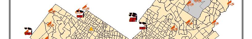
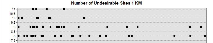
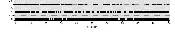
23 Geography Census Block Groups: Philadelphia County Census Tracts: Pennsylvania
24 Focus Philadelphia County Air Emission Centers Brownfields Municipal Waste Operations Pennsylvania Commercial Hazardous Waste Operations (a la UMass Study)
25 Methodology
26 Goal To determine if there is a relationship between the siting of unwanted land uses and demographics Hypothesis: Income has an inverse relationship eato with the est siting go of unwanted land uses
27 Demographics Percentage White Population Percentage Black Population Median Household Income
28 Donde Estan Los Hispánicos? H Porque no Hispanicos? Los Hispanicos son muy complicados!
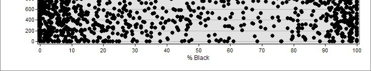
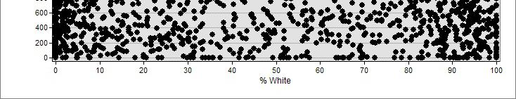
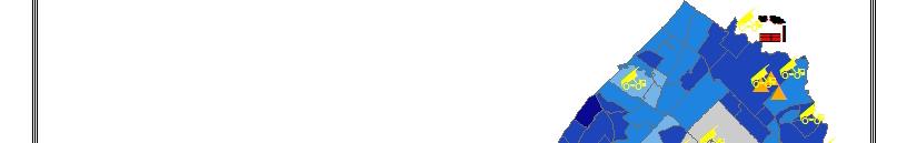
29 Analysis
30 Philadelphia The distance to the nearest ULU from the centroid of the census block Individually & Combined The number of sites within a determined ed range using linear distance ½ KM 1KM
31 Pennsylvania The distance to the nearest CHWO from the centroid of the census tract The demographics of the census tracts t containing i CHWOs vs those that do not
32 Data Extractions Outliers: 0 Population 0 Median Income


33
34
35 Results INCONCLUSIVE!
36 Philadelphia
37 Philadelphia
38 Philadelphia

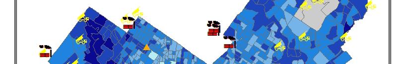
39 Philadelphia
40 Philadelphia Distance
41 Philadelphia Distance
42 Philadelphia Distance

43 Philadelphia Distance


44
45
46 Pennsylvania Distance
47 Pennsylvania Distance
48 Pennsylvania Distance
49 Census Tracts Pennsylvania With Without % Black 10.92% % Black 4.21% % Black 11.01% % White 84.39% % White 91.57% % White 84.28% Med Income Med Income Med Income
50 Discussion Demographic divide may be greater in the south Perhaps a result of segregation Gentrification largely a Northeast phenomenon, e o mainly in established s ed cities Desolation in city centers in the south may lead to different urban dynamics
51 Questions? Other than what are the determining factors in the siting of undesirable land uses?!
Geospatial Analysis of Job-Housing Mismatch Using ArcGIS and Python
 Geospatial Analysis of Job-Housing Mismatch Using ArcGIS and Python 2016 ESRI User Conference June 29, 2016 San Diego, CA Jung Seo, Frank Wen, Simon Choi and Tom Vo, Research & Analysis Southern California
Toxic Wastes and Race at Twenty:
 Chapter 3 Racial and Socioeconomic Disparities in the Distribution of Environmental Hazards: Assessing the Evidence Twenty Years after Toxic Wastes and Race* The publication in 1987 of the United Church
CRP 608 Winter 10 Class presentation February 04, Senior Research Associate Kirwan Institute for the Study of Race and Ethnicity
 CRP 608 Winter 10 Class presentation February 04, 2010 SAMIR GAMBHIR SAMIR GAMBHIR Senior Research Associate Kirwan Institute for the Study of Race and Ethnicity Background Kirwan Institute Our work Using
Spatial and Socioeconomic Analysis of Commuting Patterns in Southern California Using LODES, CTPP, and ACS PUMS
 Spatial and Socioeconomic Analysis of Commuting Patterns in Southern California Using LODES, CTPP, and ACS PUMS Census for Transportation Planning Subcommittee meeting TRB 95th Annual Meeting January 11,
PATTERNS OF HAZARDOUS WASTE IN THE UNITED STATES: ANALYZING RURAL ENVIRONMENTAL JUSTICE WITH SPATIAL DATA. Lauren Elizabeth Richter
 PATTERNS OF HAZARDOUS WASTE IN THE UNITED STATES: ANALYZING RURAL ENVIRONMENTAL JUSTICE WITH SPATIAL DATA By Lauren Elizabeth Richter MASTERS OF ARTS IN SOCIOLOGY WASHINGTON STATE UNIVERSITY Department
Spatiotemporal Analysis of Commuting Patterns in Southern California Using ACS PUMS, CTPP and LODES
 Spatiotemporal Analysis of Commuting Patterns in Southern California Using ACS PUMS, CTPP and LODES 2017 ACS Data Users Conference May 11-12, 2017 Alexandria, VA Jung Seo, Tom Vo, Frank Wen and Simon Choi
Spatiotemporal Analysis of Commuting Patterns: Using ArcGIS and Big Data
 Spatiotemporal Analysis of Commuting Patterns: Using ArcGIS and Big Data 2017 ESRI User Conference July 13, 2017 San Diego, VA Jung Seo, Tom Vo, Frank Wen and Simon Choi Research & Analysis Southern California
Environmental Analysis, Chapter 4 Consequences, and Mitigation
 Environmental Analysis, Chapter 4 4.17 Environmental Justice This section summarizes the potential impacts described in Chapter 3, Transportation Impacts and Mitigation, and other sections of Chapter 4,
Assessing Social Vulnerability to Biophysical Hazards. Dr. Jasmine Waddell
 Assessing Social Vulnerability to Biophysical Hazards Dr. Jasmine Waddell About the Project Built on a need to understand: The pre-disposition of the populations in the SE to adverse impacts from disaster
Spatial Disparities in the Distribution of Parks and Green Spaces in the United States
 March 11 th, 2012 Active Living Research Conference Spatial Disparities in the Distribution of Parks and Green Spaces in the United States Ming Wen, Ph.D., University of Utah Xingyou Zhang, Ph.D., CDC
APPENDIX V VALLEYWIDE REPORT
 APPENDIX V VALLEYWIDE REPORT Page Intentionally Left Blank 1.2 San Joaquin Valley Profile Geography The San Joaquin Valley is the southern portion of the Great Central Valley of California (Exhibit 1-1).
NCGIA. National Center for Geographic Information and Analysis. Environmental Equity. in Los Angeles
 NCGIA National Center for Geographic Information and Analysis Environmental Equity in Los Angeles by Lauretta M. Burke University of California, Santa Barbara Technical Report 93-6 July 1993 Simonett Center
Neighborhood social characteristics and chronic disease outcomes: does the geographic scale of neighborhood matter? Malia Jones
 Neighborhood social characteristics and chronic disease outcomes: does the geographic scale of neighborhood matter? Malia Jones Prepared for consideration for PAA 2013 Short Abstract Empirical research
Environmental Justice and the Environmental Protection Agency s Superfund Program
 Environmental Justice and the Environmental Protection Agency s Superfund Program Brian Alt Advance GIS 26 April 2011 Introduction In the late 1970 s the Environmental Protection Agency, the United States
Maggie M. Kovach. Department of Geography University of North Carolina at Chapel Hill
 Maggie M. Kovach Department of Geography University of North Carolina at Chapel Hill Rationale What is heat-related illness? Why is it important? Who is at risk for heat-related illness and death? Urban
Using the ACS to track the economic performance of U.S. inner cities
 Using the ACS to track the economic performance of U.S. inner cities 2017 ACS Data Users Conference May 11, 2017 Austin Nijhuis, Senior Research Analyst Initiative for a Competitive Inner (ICIC) ICIC ICIC
SOUTH COAST COASTAL RECREATION METHODS
 SOUTH COAST COASTAL RECREATION METHODS A customized, web-based survey instrument, which utilizes Point 97 s Viewpoint survey and mapping technology, was used to collect spatially explicit data on coastal
Urbanization 5/17/2002 1
 Urbanization Study of processes of urbanization in sociology is called urban sociology. Urbanization is the process of increase in the percentage of a population living in cities. A city is a densely settled
RACE AND ENVIRONMENTAL EQUITYA GIS BASED SPATIAL ANALYSIS OF PROVIDENCE, RHODE ISLAND
 University of Rhode Island DigitalCommons@URI Open Access Master's Theses 1995 RACE AND ENVIRONMENTAL EQUITYA GIS BASED SPATIAL ANALYSIS OF PROVIDENCE, RHODE ISLAND Sangeeta Jain University of Rhode Island
Hennepin GIS. Tree Planting Priority Areas - Analysis Methodology. GIS Services April 2018 GOAL:
 Hennepin GIS GIS Services April 2018 Tree Planting Priority Areas - Analysis Methodology GOAL: To create a GIS data layer that will aid Hennepin County Environment & Energy staff in determining where to
Keywords: Air Quality, Environmental Justice, Vehicle Emissions, Public Health, Monitoring Network
 NOTICE: this is the author s version of a work that was accepted for publication in Transportation Research Part D: Transport and Environment. Changes resulting from the publishing process, such as peer
The Attractive Side of Corpus Christi: A Study of the City s Downtown Economic Growth
 The Attractive Side of Corpus Christi: A Study of the City s Downtown Economic Growth GISC PROJECT DR. LUCY HUANG SPRING 2012 DIONNE BRYANT Introduction Background As a GIS Intern working with the City
BROOKINGS May
 Appendix 1. Technical Methodology This study combines detailed data on transit systems, demographics, and employment to determine the accessibility of jobs via transit within and across the country s 100
Mapping and Health Equity Advocacy
 Mapping and Health Equity Advocacy Sarah Treuhaft PolicyLink November 7, 2008 About us PolicyLink National research and action institute that advances policies to achieve economic and social equity Center
COMMUNITY SERVICE AREA
 INSTITUTE FOR TRIBAL ENVIRONMENTAL PROFESSIONALS Tribal Waste and Response Assistance Program (TWRAP) Developing and Implementing a Tribal Integrated Solid Waste Management Plan April 12-14, 2016 Palm
Spatial Analysis Of Inequity: Methods, Models, and Case Studies Jayajit Chakraborty
 Spatial Analysis Of Inequity: Methods, Models, and Case Studies Jayajit Chakraborty Professor of Geography Department of Sociology and Anthropology University of Texas at El Paso El Paso, Texas, USA jchakraborty@utep.edu
Analysis of Bank Branches in the Greater Los Angeles Region
 Analysis of Bank Branches in the Greater Los Angeles Region Brian Moore Introduction The Community Reinvestment Act, passed by Congress in 1977, was written to address redlining by financial institutions.
Environmental Justice in Dallas County Revisited: A Spatial Analysis of Landfill Sites
 Environmental Justice in Dallas County Revisited: A Spatial Analysis of Landfill Sites By Ben Witt GEOG 5520 Intermediate GIS Dr. Minhe Ji May 1, 2003 Urban growth patterns are commonly associated with
Rural Gentrification: Middle Class Migration from Urban to Rural Areas. Sevinç Bahar YENIGÜL
 'New Ideas and New Generations of Regional Policy in Eastern Europe' International Conference 7-8 th of April 2016, Pecs, Hungary Rural Gentrification: Middle Class Migration from Urban to Rural Areas
HSC Geography. Year 2013 Mark Pages 10 Published Jul 4, Urban Dynamics. By James (97.9 ATAR)
") HSC Geography Year 2013 Mark 92.00 Pages 10 Published Jul 4, 2017 Urban Dynamics By James (97.9 ATAR) Powered by TCPDF (www.tcpdf.org) Your notes author, James. James achieved an ATAR of 97.9 in 2013 while
HSC Geography Year 2013 Mark 92.00 Pages 10 Published Jul 4, 2017 Urban Dynamics By James (97.9 ATAR) Powered by TCPDF (www.tcpdf.org) Your notes author, James. James achieved an ATAR of 97.9 in 2013 while
Implications for the Sharing Economy
 Locational Big Data and Analytics: Implications for the Sharing Economy AMCIS 2017 SIGGIS Workshop Brian N. Hilton, Ph.D. Associate Professor Director, Advanced GIS Lab Center for Information Systems and
Can Public Transport Infrastructure Relieve Spatial Mismatch?
 Can Public Transport Infrastructure Relieve Spatial Mismatch? Evidence from Recent Light Rail Extensions Kilian Heilmann University of California San Diego April 20, 2015 Motivation Paradox: Even though
Environmental Justice Analysis FOR THE MINNESOTA STATEWIDE FREIGHT SYSTEM PLAN
 Environmental Justice Analysis FOR THE MINNESOTA STATEWIDE FREIGHT SYSTEM PLAN Presentation Overview Minnesota Freight Plan Summary Environmental Justice (EJ) Background Freight Plan EJ Analysis Methodology
Online Robustness Appendix to Endogenous Gentrification and Housing Price Dynamics
 Online Robustness Appendix to Endogenous Gentrification and Housing Price Dynamics Robustness Appendix to Endogenous Gentrification and Housing Price Dynamics This robustness appendix provides a variety
Effective Use of Geographic Maps
 Effective Use of Geographic Maps Purpose This tool provides guidelines and tips on how to effectively use geographic maps to communicate research findings. Format This tool provides guidance on geographic
Regional Performance Measures
 G Performance Measures Regional Performance Measures Introduction This appendix highlights the performance of the MTP/SCS for 2035. The performance of the Revenue Constrained network also is compared to
Rural Alabama. Jennifer Zanoni. Geography Division U.S. Census Bureau. Alabama State Data Center 2018 Data Conference Tuscaloosa, Alabama
 Rural Alabama Jennifer Zanoni Geography Division U.S. Census Bureau Alabama State Data Center 2018 Data Conference Tuscaloosa, Alabama May 17, 2018 Agenda Census Geography Urban/Rural Definitions County-based
Do the Causes of Poverty Vary by Neighborhood Type?
 Do the Causes of Poverty Vary by Neighborhood Type? Suburbs and the 2010 Census Conference Uday Kandula 1 and Brian Mikelbank 2 1 Ph.D. Candidate, Maxine Levin College of Urban Affairs Cleveland State
Regional Performance Measures
 G Performance Measures Regional Performance Measures Introduction This appendix highlights the performance of the MTP/SCS for 2035. The performance of the Revenue Constrained network also is compared to
Center for Urban and Regional Affairs REPORTER. Examining Environmental Equity in Hennepin County and Minneapolis
 Center for Urban and Regional Affairs REPORTER VOLUME XXIX NUMBER 3 SEPTEMBER 1999 Examining Environmental Equity in Hennepin County and Minneapolis By Eric Sheppard, Robert B. McMaster, Helga Leitner,
Using American Factfinder
 Using American Factfinder What is American Factfinder? American Factfinder is a search engine that provides access to the population, housing and economic data collected by the U.S. Census Bureau. It can
AN ENVIRONMENTAL JUSTICE ASSESSMENT OF THE MISSISSIPPI RIVER INDUSTRIAL CORRIDOR IN LOUISIANA, U.S. USING A GIS-BASED APPROACH
 - 681 - AN ENVIRONMENTAL JUSTICE ASSESSMENT OF THE MISSISSIPPI RIVER INDUSTRIAL CORRIDOR IN LOUISIANA, U.S. USING A GIS-BASED APPROACH PERERA, P.K.P. 1 * LAM, N. 2 1 Institution Department of Forestry
BIG IDEAS. Area of Learning: SOCIAL STUDIES Urban Studies Grade 12. Learning Standards. Curricular Competencies
 Area of Learning: SOCIAL STUDIES Urban Studies Grade 12 BIG IDEAS Urbanization is a critical force that shapes both human life and the planet. The historical development of cities has been shaped by geographic,
ITEM 11 Information June 20, Visualize 2045: Update to the Equity Emphasis Areas. None
 ITEM 11 Information June 20, 2018 Visualize 2045: Update to the Equity Emphasis Areas Staff Recommendation: Issues: Background: Briefing on the TPB-approved methodology to update the Equity Emphasis Areas
1Department of Demography and Organization Studies, University of Texas at San Antonio, One UTSA Circle, San Antonio, TX
 Well, it depends on where you're born: A practical application of geographically weighted regression to the study of infant mortality in the U.S. P. Johnelle Sparks and Corey S. Sparks 1 Introduction Infant
Explaining Regional Differences in Environmental Inequality
 Explaining Regional Differences in Environmental Inequality A Multi-Level Assessment of German Cities Tobias Rüttenauer Department of Social Sciences TU Kaiserslautern November 22, 2017 Analytische Soziologie
The History Behind Census Geography
 The History Behind Census Geography Michael Ratcliffe Geography Division US Census Bureau Kentucky State Data Center Affiliate Meeting August 5, 2016 Today s Presentation A brief look at the history behind
Demographic Data in ArcGIS. Harry J. Moore IV
 Demographic Data in ArcGIS Harry J. Moore IV Outline What is demographic data? Esri Demographic data - Real world examples with GIS - Redistricting - Emergency Preparedness - Economic Development Next
International Journal of Health Geographics
 International Journal of Health Geographics BioMed Central Methodology A spatial evaluation of socio demographics surrounding National Priorities List sites in Florida using a distance-based approach Greg
Name Date Period Barron s (6 th edition) Chapter 7 Urban Geography
 Chapter 7 Urban Geography") Name Date Period Barron s (6 th edition) Chapter 7 Urban Geography Historical Geography of Urban Environments 1. In what way did the development of different types of occupations (carpenters, merchants,
Name Date Period Barron s (6 th edition) Chapter 7 Urban Geography Historical Geography of Urban Environments 1. In what way did the development of different types of occupations (carpenters, merchants,
APPENDIX C-3 Equitable Target Areas (ETA) Technical Analysis Methodology
 Technical Analysis Methodology") APPENDIX C-3 Equitable Target Areas (ETA) Technical Analysis Methodology Contents Introduction... 1 ETA Index Methodology... 1 ETA Index Development... 1 Other EJ Measures... 4 The Limited English Proficiency
APPENDIX C-3 Equitable Target Areas (ETA) Technical Analysis Methodology Contents Introduction... 1 ETA Index Methodology... 1 ETA Index Development... 1 Other EJ Measures... 4 The Limited English Proficiency
Does city structure cause unemployment?
 The World Bank Urban Research Symposium, December 15-17, 2003 Does city structure cause unemployment? The case study of Cape Town Presented by Harris Selod (INRA and CREST, France) Co-authored with Sandrine
Urban Revival in America
 Urban Revival in America Victor Couture 1 Jessie Handbury 2 1 University of California, Berkeley 2 University of Pennsylvania and NBER May 2016 1 / 23 Objectives 1. Document the recent revival of America
Environmental Justice Analysis
 Environmental Justice Analysis October 2013 Transportation Department Environmental Justice Analysis Background The U.S. Environmental Protection Agency (EPA) defines environmental justice as the fair
Medical GIS: New Uses of Mapping Technology in Public Health. Peter Hayward, PhD Department of Geography SUNY College at Oneonta
 Medical GIS: New Uses of Mapping Technology in Public Health Peter Hayward, PhD Department of Geography SUNY College at Oneonta Invited research seminar presentation at Bassett Healthcare. Cooperstown,
KENTUCKY HAZARD MITIGATION PLAN RISK ASSESSMENT
 KENTUCKY HAZARD MITIGATION PLAN RISK ASSESSMENT Presentation Outline Development of the 2013 State Hazard Mitigation Plan Risk Assessment Determining risk assessment scale Census Data Aggregation Levels
LAND COVER IN OHIO S TOWNSHIPS: AN ANALYSIS OF TOWNSHIP LAND COVER AND POPULATION CHANGE
 THE EXURBAN CHANGE PROJECT REPORT NUMBER EX-3: LAND COVER IN OHIO S TOWNSHIPS: AN ANALYSIS OF TOWNSHIP LAND COVER AND POPULATION CHANGE (FEBRUARY 2002) Prepared by: Jason W. Reece Data Manager & GIS Analyst
GIS-Based Analysis of the Commuting Behavior and the Relationship between Commuting and Urban Form
 GIS-Based Analysis of the Commuting Behavior and the Relationship between Commuting and Urban Form 1. Abstract A prevailing view in the commuting is that commuting would reconstruct the urban form. By
Sidestepping the box: Designing a supplemental poverty indicator for school neighborhoods
 Sidestepping the box: Designing a supplemental poverty indicator for school neighborhoods Doug Geverdt National Center for Education Statistics Laura Nixon U.S. Census Bureau 2018 Annual meeting of the
/ lop'profe )tpartment
tpartment") GIS Methods for Screening Potential Environmental Justice Areas in New England By Chitra M. Kumar B.S., International Policy for Environment and Development Boston University (1999) Submitted to the Department
GIS Methods for Screening Potential Environmental Justice Areas in New England By Chitra M. Kumar B.S., International Policy for Environment and Development Boston University (1999) Submitted to the Department
Transit as Solution for Spatial Mismatch
 Transit as Solution for Spatial Mismatch Tianran Zeng Georgia Institute of Technology Abstract From the late 1980s, as the trend of suburbanization and welfare reform draw researchers and policymaker s
R E SEARCH HIGHLIGHTS
 Canada Research Chair in Urban Change and Adaptation R E SEARCH HIGHLIGHTS Research Highlight No.8 November 2006 THE IMPACT OF ECONOMIC RESTRUCTURING ON INNER CITY WINNIPEG Introduction This research highlight
A Comprehensive Method for Identifying Optimal Areas for Supermarket Development. TRF Policy Solutions April 28, 2011
 A Comprehensive Method for Identifying Optimal Areas for Supermarket Development TRF Policy Solutions April 28, 2011 Profile of TRF The Reinvestment Fund builds wealth and opportunity for lowwealth communities
Park Access and Distributional Inequities in Pinellas County, Florida
 University of South Florida Scholar Commons Graduate Theses and Dissertations Graduate School 2011 Park Access and Distributional Inequities in Pinellas County, Florida Kyle Ray Hirvela University of South
Valuation of environmental amenities in urban land price: A case study in the Ulaanbaatar city, Mongolia
 1989 1990 1991 1992 1993 1994 1995 1996 1997 1998 1999 2000 2001 2002 2003 2004 2005 2006 2007 2008 2009 2010 2011 Population Valuation of environmental amenities in urban land price: A case study in the
Thilo Becker
 Friedrich List Faculty of Transport and Traffic Science, Chair of Transport Ecology CAN THE CONCEPT OF ENVIRONMENTAL JUSTICE IN TRANSPORT BE TRANSFERRED TO CITIES OF THE SOUTH? A CASE STUDY OF NAIROBI
Brownfields redevelopment and gentrification: A socio-economic evaluation of the EPA Brownfields Pilot Program
 Graduate Theses and Dissertations Graduate College 2011 Brownfields redevelopment and gentrification: A socio-economic evaluation of the EPA Brownfields Pilot Program Benjamin Harrison Fisher Iowa State
A Case Study of Regional Dynamics of China 中国区域动态案例研究
 A Case Study of Regional Dynamics of China 中国区域动态案例研究 Shuming Bao Spatial Data Center & China Data Center University of Michigan 1:00 PM - 2:00 PM, Tue, Feb 6, 2018 EST USA A Case Study of Regional Dynamics
Final Group Project Paper. Where Should I Move: The Big Apple or The Lone Star State
 Final Group Project Paper Where Should I Move: The Big Apple or The Lone Star State By: Nathan Binder, Shannon Scolforo, Kristina Conste, Madison Quinones Main Goal: Determine whether New York or Texas
Application of Indirect Race/ Ethnicity Data in Quality Metric Analyses
 Background The fifteen wholly-owned health plans under WellPoint, Inc. (WellPoint) historically did not collect data in regard to the race/ethnicity of it members. In order to overcome this lack of data
TYPES OF GOVERNMENTS
 While the terms country, state, and nation are often used interchangeably, there is a difference. A State (note the capital "S") is a self-governing political entity. The term State can be used interchangeably
Spring. The City of Pittsburgh and Allegheny County. Allegheny Valley Bank of Pittsburgh. NorthWest Savings Bank. First Commonwealth
 Allegheny Valley Bank of Pittsburgh Bank of America Bank of New York Mellon Citizens Bank Dollar Bank ESB Bank Fidelity Savings Bank Fifth Third Bank First Commonwealth Huntington Bank Iron and Glass Bank
Links between socio-economic and ethnic segregation at different spatial scales: a comparison between The Netherlands and Belgium
 Links between socio-economic and ethnic segregation at different spatial scales: a comparison between The Netherlands and Belgium Bart Sleutjes₁ & Rafael Costa₂ ₁ Netherlands Interdisciplinary Demographic
Research Update: Race and Male Joblessness in Milwaukee: 2008
 Research Update: Race and Male Joblessness in Milwaukee: 2008 by: Marc V. Levine University of Wisconsin Milwaukee Center for Economic Development Briefing Paper September 2009 Overview Over the past decade,
Demographic Change Near Rail Stations
 4/10/2015 Demographic Change Near Rail Stations University of North Carolina at Chapel Hill Department of City and Regional Planning TABLE OF CONTENTS Introduction... 3 1. Literature Review... 3 2. Methodology...
Visualization of Origin- Destination Commuter Flow Using CTPP Data and ArcGIS
 Visualization of Origin- Destination Commuter Flow Using CTPP Data and ArcGIS Research & Analysis Department Southern California Association of Governments 2015 ESRI User Conference l July 23, 2015 l San
TUESDAYS AT APA PLANNING AND HEALTH. SAGAR SHAH, PhD AMERICAN PLANNING ASSOCIATION SEPTEMBER 2017 DISCUSSING THE ROLE OF FACTORS INFLUENCING HEALTH
 SAGAR SHAH, PhD sshah@planning.org AMERICAN PLANNING ASSOCIATION SEPTEMBER 2017 TUESDAYS AT APA PLANNING AND HEALTH DISCUSSING THE ROLE OF FACTORS INFLUENCING HEALTH Outline of the Presentation PLANNING
ADDRESSING TITLE VI AND ENVIRONMENTAL JUSTICE IN LONG-RANGE TRANSPORTATION PLANS
 ADDRESSING TITLE VI AND ENVIRONMENTAL JUSTICE IN LONG-RANGE TRANSPORTATION PLANS Activities from the National Capital Region Transportation Planning Board Sergio Ritacco Transportation Planner 2017 Association
The Elusive Connection between Density and Transit Use
 The Elusive Connection between Density and Transit Use Abstract: The connection between density and transportation is heralded by planners, yet results are often elusive. This paper analyzes two regions,
Developing Spatial Data to Support Statistical Analysis of Education
 Developing Spatial Data to Support Statistical Analysis of Education Doug Geverdt National Center for Education Statistics Education Demographic and Geographic Estimates (EDGE) Program 2016 ESRI User Conference
HORIZON 2030: Land Use & Transportation November 2005
 PROJECTS Land Use An important component of the Horizon transportation planning process involved reviewing the area s comprehensive land use plans to ensure consistency between them and the longrange transportation
STAR COMMUNITY RATING SYSTEM OBJECTIVE EE-4: EQUITABLE SERVICES & ACCESS COMMUNITY LEVEL OUTCOMES FOR KING COUNTY, WA
 STAR COMMUNITY RATING SYSTEM OBJECTIVE EE-4: EQUITABLE SERVICES & ACCESS COMMUNITY LEVEL OUTCOMES FOR KING COUNTY, WA OUTCOME I: EQUITABLE ACCESS AND PROXIMITY Background: This analysis has been developed
MPOs SB 375 LAFCOs SCAG Practices/Experiences And Future Collaborations with LAFCOs
 Connecting LAFCOs and COGs for Mutual Benefits MPOs SB 375 LAFCOs SCAG Practices/Experiences And Future Collaborations with LAFCOs Frank Wen, Manager Research & Analysis Land Use & Environmental Planning
Integrating GIS into Food Access Analysis
 GIS Day at Kansas University Integrating GIS into Food Access Analysis Daoqin Tong School of Geography and Development Outline Introduction Research questions Method Results Discussion Introduction Food
Chapter 13 Study Guide: Urban Geography Cities in the periphery, Latin America, and Europe
 Chapter 13 Study Guide: Urban Geography Cities in the periphery, Latin America, and Europe Compared to the private automobile, public transportation offers more energy efficiency. Public transit is more
DEVELOPING DECISION SUPPORT TOOLS FOR THE IMPLEMENTATION OF BICYCLE AND PEDESTRIAN SAFETY STRATEGIES
 DEVELOPING DECISION SUPPORT TOOLS FOR THE IMPLEMENTATION OF BICYCLE AND PEDESTRIAN SAFETY STRATEGIES Deo Chimba, PhD., P.E., PTOE Associate Professor Civil Engineering Department Tennessee State University
A Street Named for a King
 A Street Named for a King Dr. Jerry Mitchell University of South Carolina OVERVIEW This lesson adapts the work of Dr. Derek Alderman, a geographer who has used the Martin Luther King, Jr. street-naming
Planning for Economic and Job Growth
 Planning for Economic and Job Growth Mayors Innovation Project Winter 2012 Meeting January 21, 2012 Mary Kay Leonard Initiative for a Competitive Inner City AGENDA The Evolving Model for Urban Economic
Applying Health Outcome Data to Improve Health Equity
 Applying Health Outcome Data to Improve Health Equity Devon Williford, MPH, Health GIS Specialist Lorraine Dixon-Jones, Policy Analyst CDPHE Health Equity and Environmental Justice Collaborative Mile High
ARIC Manuscript Proposal # PC Reviewed: _9/_25_/06 Status: A Priority: _2 SC Reviewed: _9/_25_/06 Status: A Priority: _2
 ARIC Manuscript Proposal # 1186 PC Reviewed: _9/_25_/06 Status: A Priority: _2 SC Reviewed: _9/_25_/06 Status: A Priority: _2 1.a. Full Title: Comparing Methods of Incorporating Spatial Correlation in
Equity, Accessibility and Transit Use in large American cities
 Equity, Accessibility and Transit Use in large American cities Submitted: 1 August 2004 Word Count: 4600 + 1500 = 6100 Murtaza Haider, Ph.D. McGill University, School of Urban Planning 815 Sherbrooke St.
Spatial Organization of Data and Data Extraction from Maptitude
 Spatial Organization of Data and Data Extraction from Maptitude N. P. Taliceo Geospatial Information Sciences The University of Texas at Dallas UT Dallas GIS Workshop Richardson, TX March 30 31, 2018 1/
NEW YORK DEPARTMENT OF SANITATION. Spatial Analysis of Complaints
 NEW YORK DEPARTMENT OF SANITATION Spatial Analysis of Complaints Spatial Information Design Lab Columbia University Graduate School of Architecture, Planning and Preservation November 2007 Title New York
Abortion Facilities Target College Students
 Target College Students By Kristan Hawkins Executive Director, Students for Life America Ashleigh Weaver Researcher Abstract In the Fall 2011, Life Dynamics released a study entitled, Racial Targeting
A.P. Human Geography
 A.P. Human Geography 2012-2013 Instructor: Chris Vitt Brief Description of Course AP Human Geography is designed to provide students with a learning experience equivalent to that obtained in most college
Abstract. [Map 1] [Map 2] [Map 3] [Figures 1, 2, and 3] Metropolitan Transportation Commission - Oakland, California. Defining Communities of Concern
![Abstract. [Map 1] [Map 2] [Map 3] [Figures 1, 2, and 3] Metropolitan Transportation Commission - Oakland, California. Defining Communities of Concern](/thumbs/77/75685724.jpg "Abstract. [Map 1] [Map 2] [Map 3] [Figures 1, 2, and 3] Metropolitan Transportation Commission - Oakland, California. Defining Communities of Concern") Environmental Justice for Long-Range Regional Transportation Plans: Using Census Data to Target Communities of Concern Presented By: Rachel Gossen Project Team: Therese Knudsen, Chuck Purvis, Rachel Gossen
Environmental Justice for Long-Range Regional Transportation Plans: Using Census Data to Target Communities of Concern Presented By: Rachel Gossen Project Team: Therese Knudsen, Chuck Purvis, Rachel Gossen
Using Census Public Use Microdata Areas (PUMAs) as Primary Sampling Units in Area Probability Household Surveys
 as Primary Sampling Units in Area Probability Household Surveys") Using Census Public Use Microdata Areas (PUMAs) as Primary Sampling Units in Area Probability Household Surveys Joe McMichael, Patrick Chen RTI International, 1 3040 Cornwallis Road, Research Triangle
Using Census Public Use Microdata Areas (PUMAs) as Primary Sampling Units in Area Probability Household Surveys Joe McMichael, Patrick Chen RTI International, 1 3040 Cornwallis Road, Research Triangle
Tracey Farrigan Research Geographer USDA-Economic Research Service
 Rural Poverty Symposium Federal Reserve Bank of Atlanta December 2-3, 2013 Tracey Farrigan Research Geographer USDA-Economic Research Service Justification Increasing demand for sub-county analysis Policy
PALS: Neighborhood Identification, City of Frederick, Maryland. David Boston Razia Choudhry Chris Davis Under the supervision of Chao Liu
 PALS: Neighborhood Identification, City of Frederick, Maryland David Boston Razia Choudhry Chris Davis Under the supervision of Chao Liu University of Maryland School of Architecture, Planning & Preservation
Regional Growth Strategy Regional Staff Committee
 Regional Growth Strategy Regional Staff Committee June 21, 2018 1 Overview Summary of June Growth Management Policy Board Regional Growth Strategy Objectives Regional Geographies Regional Growth Strategy