NASA, EPA, USGS Partnership. U.S. Department of the Interior U.S. Geological Survey
|
|
|
- Nicholas Henry
- 5 years ago
- Views:
Transcription
1 Spatial and Temporal Dimensions of Contemporary U.S. Land Cover/Land Use Change and Implications for Carbon Dynamics Tom Loveland and Shuguang Liu USGS EROS Data Center, Sioux Falls, SD NASA, EPA, USGS Partnership U.S. Department of the Interior U.S. Geological Survey
2 Land Cover Trends/Carbon Implications Research Team! Tom Loveland Principle Investigator, Geographic Assessment! Shuguang Liu Carbon Assessment! Terry Sohl - Change Analysis, Sampling! Kristi Sayler - Change Analysis, Biophysical Variables! Alisa Gallant - Change Analysis, Landscape Pattern Analysis! Greg Zylstra - Biophysical Variables, Radiometry! Darrell Napton (SDSU) - Driving Forces, Consequences! Steve Stehman (SUNY Syracuse) - Sampling, Accuracy Assessment
3 Research Objectives Land Cover Change Assessment - Document the types, geographic distribution, and rates of 1970 s to 2000 U.S. land use and land cover change in order to answer the following:! What are the spatial and temporal dimensions of land use and land cover change?! What are the regional driving forces of contemporary land use and land cover change?
4 Research Objectives Carbon Dynamics Assessment Isolate and identify the explicit role of local land use/land cover change in affecting contemporary regional and national carbon dynamics across the U.S. " What are the spatial and temporal distributions of carbon sources and sinks? " What are the mechanisms that cause these distributions? " What are the uncertainties in carbon dynamics related to LU/LC change?
5 Methodology! Spatial Framework # Omernik ecoregions; probability sample of 20 km by 20 km blocks allocated by ecoregion! Land Cover Assessment # Analyze change for each sample using 1973, 1980, 1986, 1992, and 2000 Landsat MSS, TM, ETM+. # Hybrid contextual change vector/manual interpretation approach.
6 Sampling Strategy! Random selection of 20 km by 20 km blocks for each ecoregion.! Sample size of approximately 800 blocks based on: k=1/(1/k o + 1/K) k=planned sample size K=number of blocks in ecoregion k o =(z$/m) 2 with: z = percentile from the normal distribution (0.85) $ = StDev of the number of change pixels per block m = margin of error (±1.0%)

7
8 Land Cover Variables! General land cover types # Developed/built-up # Agriculture # Forest and woodland # Rangeland/grassland # Wetland # Water bodies # Snow and ice # Natural barren # Mined lands # Mechanical disturbed or transitional # Non-mechanical disturbed or transitional
9 Methods, Carbon Assessment! Carbon Dynamics Assessment # Develop land cover, land use, soils, and climate data sets for each 20x20 km sample block. # Apply cohort-statistical-simulation (CoSim) method to develop joint frequency distributions for CENTURY model parameters. # Apply CENTURY model to estimate carbon dynamics for each sample site, assess the variability of carbon responses to land use change, and determine confidence limits on simulated results. # Summarize ecoregion-wide carbon dynamics.
10 Data Requirements " Landsat Data " 1973, 1980, 1986, 1992 MSS (NALC) " 1992 TM, 2000 ETM+ (MRLC) " County Statistics # Population # Agricultural characteristics # Employment by economic sector # Housing (e.g., total units, occupied units) " STATSGO soil polygons, attributes " National Climate Data Center - precipitation and temperature data " National Atmospheric Deposition Program atmospheric nitrogen

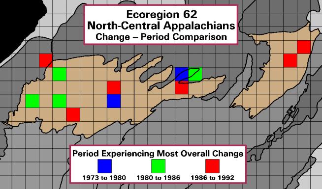
11 North Central Appalachians Ecoregion

12
13 North Central Appalachia Rates of Land Cover Change Cover Water 1.6% 1.6% 1.6% 1.6% Urban/Built-Up 0.7% 0.8% 0.9% 0.9% Transitional 1.1% 1.2% 1.4% 1.2% Mining/Quarries 0.4% 0.5% 0.5% 0.7% Forests and Woods 91.5% 91.2% 91.1% 91.1% Agriculture 3.9% 3.9% 3.7% 3.7% Wetlands 0.7% 0.7% 0.7% 0.7%

14 Cumulative Land Cover Change! Overall, 4.14% of the ecoregion landscape changed between 1972 and 1992.

15
16

17 Joint Frequency Distribution of STATSGO MUID, County Boundary, and Land Cover in 1973, 1979, 1987 and 1991 Sample Block 1 in Ecoregion 62
18 FY2000 Accomplishments! Land Cover Change Assessment # Land cover change methods developed, tested # Interpretation of 4 ecoregions completed! Carbon Dynamics Assessment # Graphic user interface is nearly completed # Methods for extracting STATSGO attributes, Joint Frequency Distribution (JFD) completed # CENTURY linkages to STATSGO, climate data and land cover data has been completed # Testing at Sample Block 1 in Ecoregion 62
19 FY 2001 Work Schedule Land Cover Change Analysis! Incorporate 2000 Landsat ETM+ data into analysis.! Complete analysis of ecoregions (emphasis on Eastern United States).! Publish manuscripts on methodology and pilot phase results.
20 FY 2001 Work Schedule Carbon Modeling! Complete all the model-data linkages required for model simulation.! Finish the development of the graphic user interface (GUI)! Use the GUI to run model simulations over 10 to 20 ecoregions! Publish results
21 Science Implications! Objective understanding of the spatial and temporal dimensions of conterminous U.S. LU/LC change.! Identify local to regional carbon dynamics linkages.! Demonstrate a framework for large-area land cover/carbon dynamics monitoring.
The Influence of Historical and Projected Land Use and Land Cover Changes on Land Surface Hydrology and Regional Weather and Climate Variability
 The Influence of Historical and Projected Land Use and Land Cover Changes on Land Surface Hydrology and Regional Weather and Climate Variability Research Hypothesis: Land use and land cover changes are
Utility of National Spatial Data for Conservation Design Projects
 Utility of National Spatial Data for Conservation Design Projects Steve Williams Biodiversity and Spatial Information Center North Carolina State University PIF CDW St. Louis, MO April 11, 2006 Types of
U.S. Department of the Interior U.S. Geological Survey. Krista Karstensen Mark Drummond
 USGS Land-Cover Trends: A focus on contemporary land-use and land-cover change within the LCCs U.S. Department of the Interior U.S. Geological Survey Krista Karstensen Mark Drummond The Challenge Land
An Internet-based Agricultural Land Use Trends Visualization System (AgLuT)
") An Internet-based Agricultural Land Use Trends Visualization System (AgLuT) Prepared for Missouri Department of Natural Resources Missouri Department of Conservation 07-01-2000-12-31-2001 Submitted by
An Internet-based Agricultural Land Use Trends Visualization System (AgLuT) Prepared for Missouri Department of Natural Resources Missouri Department of Conservation 07-01-2000-12-31-2001 Submitted by
CHAPTER 1 THE UNITED STATES 2001 NATIONAL LAND COVER DATABASE
 CHAPTER 1 THE UNITED STATES 2001 NATIONAL LAND COVER DATABASE Collin Homer*, Jon Dewitz, Joyce Fry, and Nazmul Hossain *U.S. Geological Survey (USGS) Center for Earth Resources Observation and Science
LCMAP Workshop Welcome. Jesslyn F. Brown USGS/EROS Nov 6, 2018
 LCMAP Workshop Welcome Jesslyn F. Brown USGS/EROS Nov 6, 2018 LCMAP: Workshop Goals Land Change Monitoring, Analysis, and Projection (LCMAP) Provide an update on current status (Version 1) Algorithm approaches
USGS/EROS Accomplishments and Year 3 Plans. Enhancement of the U.S. Drought Monit Through the Integration of NASA Vegetation Index Imagery
 USGS/EROS Accomplishments and Year 3 Plans Enhancement of the U.S. Drought Monit Through the Integration of NASA Vegetation Index Imagery Jesslyn Brown Team Meeting, Austin, TX, 10/6/09 U.S. Department
AGOG 485/585 /APLN 533 Spring Lecture 5: MODIS land cover product (MCD12Q1). Additional sources of MODIS data
. Additional sources of MODIS data") AGOG 485/585 /APLN 533 Spring 2019 Lecture 5: MODIS land cover product (MCD12Q1). Additional sources of MODIS data Outline Current status of land cover products Overview of the MCD12Q1 algorithm Mapping
AGOG 485/585 /APLN 533 Spring 2019 Lecture 5: MODIS land cover product (MCD12Q1). Additional sources of MODIS data Outline Current status of land cover products Overview of the MCD12Q1 algorithm Mapping
Principals and Elements of Image Interpretation
 Principals and Elements of Image Interpretation 1 Fundamentals of Photographic Interpretation Observation and inference depend on interpreter s training, experience, bias, natural visual and analytical
Greening of Arctic: Knowledge and Uncertainties
 Greening of Arctic: Knowledge and Uncertainties Jiong Jia, Hesong Wang Chinese Academy of Science jiong@tea.ac.cn Howie Epstein Skip Walker Moscow, January 28, 2008 Global Warming and Its Impact IMPACTS
A Strategy for Es" -- - "-- g the Rates of
 A Strategy for Es" -- - "-- g the Rates of Recent United States L--- $Cover Changes T.R. Loveland, T.L. Sohl, S.V. Stehman, A.L. Gallant, K.L. Sayler, and D.E. Napton Abstract Information on the rates
2011 Land Use/Land Cover Delineation. Meghan Jenkins, GIS Analyst, GISP Jennifer Kinzer, GIS Coordinator, GISP
 2011 Land Use/Land Cover Delineation Meghan Jenkins, GIS Analyst, GISP Jennifer Kinzer, GIS Coordinator, GISP History O Key Points O Based on Anderson s Land Use and Land Cover Classification System O
The Landsat Program and its Products: Global Land Surveys. Garik Gutman LCLUC Program Manager NASA Headquarters Washington, DC
 The Landsat Program and its Products: Global Land Surveys Garik Gutman LCLUC Program Manager NASA Headquarters Washington, DC 1 Land-Cover/Land-Use Change Program LCLUC is an interdisciplinary scientific
APPENDIX. Normalized Difference Vegetation Index (NDVI) from MODIS data
 from MODIS data") APPENDIX Land-use/land-cover composition of Apulia region Overall, more than 82% of Apulia contains agro-ecosystems (Figure ). The northern and somewhat the central part of the region include arable lands
APPENDIX Land-use/land-cover composition of Apulia region Overall, more than 82% of Apulia contains agro-ecosystems (Figure ). The northern and somewhat the central part of the region include arable lands
Regionalized and application-specific compositing - a review of requirements, opportunities and challenges
 Regionalized and application-specific compositing - a review of requirements, opportunities and challenges Patrick Griffiths & Patrick Hostert Geography Department, Humboldt University Berlin Joanne White
An Internet-based Agricultural Land Use Trends Visualization System (AgLuT)
") An Internet-based Agricultural Land Use Trends Visualization System (AgLuT) Second half yearly report 01-01-2001-06-30-2001 Prepared for Missouri Department of Natural Resources Missouri Department of
An Internet-based Agricultural Land Use Trends Visualization System (AgLuT) Second half yearly report 01-01-2001-06-30-2001 Prepared for Missouri Department of Natural Resources Missouri Department of
Eco-hydromorphic Characterization of the Louisiana Coastal Region Using Multiple Remotely Sensed Data Sources and Analyses
 National Wetlands Research Center Eco-hydromorphic Characterization of the Louisiana Coastal Region Using Multiple Remotely Sensed Data Sources and Analyses 1Holly Beck, 2 Brady Couvillion, 1 Nadine Trahan
Sources of Imagery and GIS Data Layers (Last updated October 2005)
") Sources of Imagery and GIS Data Layers (Last updated October 2005) The question of where to find data is one often asked by beginners in precision agriculture and other geospatial projects. The following
Sources of Imagery and GIS Data Layers (Last updated October 2005) The question of where to find data is one often asked by beginners in precision agriculture and other geospatial projects. The following
Rangeland Carbon Fluxes in the Northern Great Plains
 Rangeland Carbon Fluxes in the Northern Great Plains Wylie, B.K., T.G. Gilmanov, A.B. Frank, J.A. Morgan, M.R. Haferkamp, T.P. Meyers, E.A. Fosnight, L. Zhang US Geological Survey National Center for Earth
Land Accounts - The Canadian Experience
 Land Accounts - The Canadian Experience Development of a Geospatial database to measure the effect of human activity on the environment Who is doing Land Accounts Statistics Canada (national) Component
Fig 1. Steps in the EcoValue Project
 Assessing the Social and Economic Value of Ecosystem Services in the Northern Forest Region: A Geographic Information System (GIS) Approach to Landscape Valuation Principal Investigator(s): Dr. Matthew
Data Fusion and Multi-Resolution Data
 Data Fusion and Multi-Resolution Data Nature.com www.museevirtuel-virtualmuseum.ca www.srs.fs.usda.gov Meredith Gartner 3/7/14 Data fusion and multi-resolution data Dark and Bram MAUP and raster data Hilker
Land cover/land use mapping and cha Mongolian plateau using remote sens. Title. Author(s) Bagan, Hasi; Yamagata, Yoshiki. Citation Japan.
 Bagan, Hasi; Yamagata, Yoshiki. Citation Japan.") Title Land cover/land use mapping and cha Mongolian plateau using remote sens Author(s) Bagan, Hasi; Yamagata, Yoshiki International Symposium on "The Imp Citation Region Specific Systems". 6 Nove Japan.
Title Land cover/land use mapping and cha Mongolian plateau using remote sens Author(s) Bagan, Hasi; Yamagata, Yoshiki International Symposium on "The Imp Citation Region Specific Systems". 6 Nove Japan.
A Strategy for Estimating Tree Canopy Density Using Landsat 7 ETM+ and High Resolution Images Over Large Areas
 University of Nebraska - Lincoln DigitalCommons@University of Nebraska - Lincoln Publications of the US Geological Survey US Geological Survey 2001 A Strategy for Estimating Tree Canopy Density Using Landsat
3rd LCLUC Science Team Meeting Airlie House, Warrenton, Va May
 3rd LCLUC Science Team Meeting Airlie House, Warrenton, Va May 18-21 1999 May 18 th Day 1, 9.00 am Plenary Session - The Jefferson Room Welcome and Objectives of the Meeting C. Justice / J. Ranson Programmatic
ANCILLARY DATA VARIABLES
 ANCILLARY DATA VARIABLES PROCESSING INFORMATION AND MODELING USES Version 1.0 1 BACKGROUND The ancillary data component of the project included creation of a core dataset of 58 variables, of which 24 variables
Comparing the Land Use and Land Cover Changes Between the North and South Louisiana Using Data Mining
 Comparing the Land Use and Land Cover Changes Between the North and South Louisiana Using Data Mining Yi Qiang and Nina Lam Department of Environmental Sciences Louisiana State University yqiang1@lsu.edu,
Watershed Application of WEPP and Geospatial Interfaces. Dennis C. Flanagan
 Watershed Application of WEPP and Geospatial Interfaces Dennis C. Flanagan Research Agricultural Engineer USDA-Agricultural Research Service Adjunct Professor Purdue Univ., Dept. of Agric. & Biol. Eng.
The Wide Dynamic Range Vegetation Index and its Potential Utility for Gap Analysis
 Summary StatMod provides an easy-to-use and inexpensive tool for spatially applying the classification rules generated from the CT algorithm in S-PLUS. While the focus of this article was to use StatMod
Vegetation Change Detection of Central part of Nepal using Landsat TM
 Vegetation Change Detection of Central part of Nepal using Landsat TM Kalpana G. Bastakoti Department of Geography, University of Calgary, kalpanagb@gmail.com Abstract This paper presents a study of detecting
Preparation of LULC map from GE images for GIS based Urban Hydrological Modeling
 International Conference on Modeling Tools for Sustainable Water Resources Management Department of Civil Engineering, Indian Institute of Technology Hyderabad: 28-29 December 2014 Abstract Preparation
NIDIS Remote Sensing Workshop: Showcase of Products & Technologies
 Feature Article From Intermountain West Climate Summary, April 2008 NIDIS Remote Sensing Workshop: Showcase of Products & Technologies By Christina Alvord of WWA Three knowledge assessment workshops are
MAPPING LAND USE/ LAND COVER OF WEST GODAVARI DISTRICT USING NDVI TECHNIQUES AND GIS Anusha. B 1, Sridhar. P 2
 MAPPING LAND USE/ LAND COVER OF WEST GODAVARI DISTRICT USING NDVI TECHNIQUES AND GIS Anusha. B 1, Sridhar. P 2 1 M. Tech. Student, Department of Geoinformatics, SVECW, Bhimavaram, A.P, India 2 Assistant
INTERNATIONAL JOURNAL OF GEOMATICS AND GEOSCIENCES Volume 2, No 1, 2011
 INTERNATIONAL JOURNAL OF GEOMATICS AND GEOSCIENCES Volume 2, No 1, 2011 Copyright 2010 All rights reserved Integrated Publishing services Research article ISSN 0976 4380 Spatio-Temporal changes of Land
Defense Meteorological Satellite Program. Sprawl. Sprawl Highlights
 Sprawl Sprawl Highlights file://d:\index.html README for data files included on this CD-ROM Page 1 of 2 README for data files included on this CD-ROM ****************************************************************************
Fundamentals of Photographic Interpretation
 Principals and Elements of Image Interpretation Fundamentals of Photographic Interpretation Observation and inference depend on interpreter s training, experience, bias, natural visual and analytical abilities.
Monitoring Vegetation Growth of Spectrally Landsat Satellite Imagery ETM+ 7 & TM 5 for Western Region of Iraq by Using Remote Sensing Techniques.
 Monitoring Vegetation Growth of Spectrally Landsat Satellite Imagery ETM+ 7 & TM 5 for Western Region of Iraq by Using Remote Sensing Techniques. Fouad K. Mashee, Ahmed A. Zaeen & Gheidaa S. Hadi Remote
EnviroAtlas: An Atlas about Ecosystems and their Connection with People
 EnviroAtlas: An Atlas about Ecosystems and their Connection with People Annie Neale, Megan Mehaffey & Atlas Team ASWM Webinar October, 17 th, 2012 What is it? The Atlas is an online decision support tool
Use of Corona, Landsat TM, Spot 5 images to assess 40 years of land use/cover changes in Cavusbasi
 New Strategies for European Remote Sensing, Olui (ed.) 2005 Millpress, Rotterdam, ISBN 90 5966 003 X Use of Corona, Landsat TM, Spot 5 images to assess 40 years of land use/cover changes in Cavusbasi N.
The growth of urban Kolkata, India and its impact on the precipitation processes. Chandana Mitra Department of Geography University of Georgia
 The growth of urban Kolkata, India and its impact on the precipitation processes Chandana Mitra Department of Geography University of Georgia Kolkata City - Background 300 year old city - Garrison town
Appendix 1: UK climate projections
 Appendix 1: UK climate projections The UK Climate Projections 2009 provide the most up-to-date estimates of how the climate may change over the next 100 years. They are an invaluable source of information
Automated GIS routine for Strategic Environmental Assessment: a spatiotemporal analysis of urban and wetland change
 Automated GIS routine for Strategic Environmental Assessment: a spatiotemporal analysis of urban and wetland change Anton Sizo 1, Scott Bell 2, and Bram Noble 3 1 Geography and Planning, University of
Geography (GEOG) Introduction to Geography Global Change and Natural Disasters and Environmental Change
 Introduction to Geography Global Change and Natural Disasters and Environmental Change") Geography (GEOG) Head of Department: Professor Jeffrey P. Osleeb Department Office: Room 422, Philip E. Austin Building For major requirements, see the College of Liberal Arts and Sciences section of this
Geography (GEOG) Head of Department: Professor Jeffrey P. Osleeb Department Office: Room 422, Philip E. Austin Building For major requirements, see the College of Liberal Arts and Sciences section of this
A comprehensive change detection method for updating the National Land Cover Database to circa 2011
 University of Nebraska - Lincoln DigitalCommons@University of Nebraska - Lincoln USGS Staff -- Published Research US Geological Survey 2013 A comprehensive change detection method for updating the National
URBAN CHANGE DETECTION OF LAHORE (PAKISTAN) USING A TIME SERIES OF SATELLITE IMAGES SINCE 1972
 USING A TIME SERIES OF SATELLITE IMAGES SINCE 1972") URBAN CHANGE DETECTION OF LAHORE (PAKISTAN) USING A TIME SERIES OF SATELLITE IMAGES SINCE 1972 Omar Riaz Department of Earth Sciences, University of Sargodha, Sargodha, PAKISTAN. omarriazpk@gmail.com ABSTRACT
URBAN CHANGE DETECTION OF LAHORE (PAKISTAN) USING A TIME SERIES OF SATELLITE IMAGES SINCE 1972 Omar Riaz Department of Earth Sciences, University of Sargodha, Sargodha, PAKISTAN. omarriazpk@gmail.com ABSTRACT
Phase 6 Land Use Database version 2
 Phase 6 Land Use Database version 2 Peter Claggett, Fred Irani, Quentin Stubbs, and Renee Thompson. October 5, 2015 Modeling Workgroup Quarterly Annapolis, Maryland U.S. Department of the Interior U.S.
Maximizing Geospatial Baseline Data for Optimizing Landsat Imageries: Assessing Climate Change Impacts
 Maximizing Geospatial Baseline Data for Optimizing Landsat Imageries: Assessing Climate Change Impacts B. Acharya, PhD, PLS Earth Mapping International B. Gyawali, PhD Kentucky State University D. Zourarakis,
Land Use/Cover Changes & Modeling Urban Expansion of Nairobi City
 Land Use/Cover Changes & Modeling Urban Expansion of Nairobi City Overview Introduction Objectives Land use/cover changes Modeling with Cellular Automata Conclusions Introduction Urban land use/cover types
Sneak Preview of the Saskatchewan Soil Information System (SKSIS)
") Sneak Preview of the Saskatchewan Soil Information System (SKSIS) Angela Bedard-Haughn 1, Ken Van Rees 1, Murray Bentham 1, Paul Krug 1 Kent Walters 1,3, Brandon Heung 2, Tom Jamsrandorj 3 Ralph Deters
Sneak Preview of the Saskatchewan Soil Information System (SKSIS) Angela Bedard-Haughn 1, Ken Van Rees 1, Murray Bentham 1, Paul Krug 1 Kent Walters 1,3, Brandon Heung 2, Tom Jamsrandorj 3 Ralph Deters
Development of statewide 30 meter winter sage grouse habitat models for Utah
 Development of statewide 30 meter winter sage grouse habitat models for Utah Ben Crabb, Remote Sensing and Geographic Information System Laboratory, Department of Wildland Resources, Utah State University
RESEARCH METHODOLOGY
 III. RESEARCH METHODOLOGY 3.1 Time and Location This research has been conducted in period March until October 2010. Location of research is over Sumatra terrain. Figure 3.1 show the area of interest of
Land Use/Land Cover Mapping in and around South Chennai Using Remote Sensing and GIS Techniques ABSTRACT
 Land Use/Land Cover Mapping in and around South Chennai Using Remote Sensing and GIS Techniques *K. Ilayaraja, Abhishek Singh, Dhiraj Jha, Kriezo Kiso, Amson Bharath institute of Science and Technology
Drought Estimation Maps by Means of Multidate Landsat Fused Images
 Remote Sensing for Science, Education, Rainer Reuter (Editor) and Natural and Cultural Heritage EARSeL, 2010 Drought Estimation Maps by Means of Multidate Landsat Fused Images Diego RENZA, Estíbaliz MARTINEZ,
to low order streams, or percolated down to the water table (Yang et al., 2009). The prevalence of
. The prevalence of") Introduction The Effect of Land-cover Changes on Lag Time in the Banklick Creek Watershed, KY Katelyn Toebbe University of Louisville Department of Geography and Geosciences Urbanization in a watershed
Introduction The Effect of Land-cover Changes on Lag Time in the Banklick Creek Watershed, KY Katelyn Toebbe University of Louisville Department of Geography and Geosciences Urbanization in a watershed
IDENTIFICATION OF TRENDS IN LAND USE/LAND COVER CHANGES IN THE MOUNT CAMEROON FOREST REGION
 IDENTIFICATION OF TRENDS IN LAND USE/LAND COVER CHANGES IN THE MOUNT CAMEROON FOREST REGION By Nsorfon Innocent F. April 2008 Content Introduction Problem Statement Research questions/objectives Methodology
Sensitivity of AERSURFACE Results to Study Area and Location. Paper 2009-A-127-AWMA
 Sensitivity of AERSURFACE Results to Study Area and Location Paper 2009-A-127-AWMA Prepared by: Anthony J. Schroeder, CCM Senior Consultant George J. Schewe, CCM, QEP Principal Consultant Trinity Consultants
SPATIAL AND TEMPORAL MODELLING OF ECOSYSTEM SERVICES
 SPATIAL AND TEMPORAL MODELLING OF ECOSYSTEM SERVICES Solen Le Clec h, T.Decaëns, S. Dufour, M. Grimaldi, N. Jégou and J. Oszwald ACES Conference 2016 Jacksonville, Florida (USA). December, 5-9th : issues
USING LANDSAT IN A GIS WORLD
 USING LANDSAT IN A GIS WORLD RACHEL MK HEADLEY; PHD, PMP STEM LIAISON, ACADEMIC AFFAIRS BLACK HILLS STATE UNIVERSITY This material is based upon work supported by the National Science Foundation under
Opportunities to Develop an Interagency Spatial Hierarchy for ESD Applications
 Opportunities to Develop an Interagency Spatial Hierarchy for ESD Applications Presentation Outline Brief history of ecological classification and mapping What is a spatial hierarchy concepts and examples
Developed new methodologies for mapping and characterizing suburban sprawl in the Northeastern Forests
 Development of Functional Ecological Indicators of Suburban Sprawl for the Northeastern Forest Landscape Principal Investigator: Austin Troy UVM, Rubenstein School of Environment and Natural Resources
Use of climate reanalysis for EEA climate change assessment. Blaz Kurnik. European Environment Agency (EEA)
") Use of climate reanalysis for EEA climate change assessment Blaz Kurnik European Environment Agency (EEA) 2016: EEA content priorities Circular economy Climate and Energy Sustainable Development Goals
Use of climate reanalysis for EEA climate change assessment Blaz Kurnik European Environment Agency (EEA) 2016: EEA content priorities Circular economy Climate and Energy Sustainable Development Goals
MODELING RUNOFF RESPONSE TO CHANGING LAND COVER IN PENGANGA SUBWATERSHED, MAHARASHTRA
 MODELING RUNOFF RESPONSE TO CHANGING LAND COVER IN PENGANGA SUBWATERSHED, MAHARASHTRA Abira Dutta Roy*, S.Sreekesh** *Research Scholar, **Associate Professor Centre for the Study of Regional Development,
DEVELOP National Program
 DEVELOP National Program GLSLCI 2015 Annual Meeting and Conference Sarnia, Ontario 19 June 2015 DEVELOP National Program NASA GLSLCI 2015 June 2015 NASA Earth observations NASA Earth observations include
Comparison between Land Surface Temperature Retrieval Using Classification Based Emissivity and NDVI Based Emissivity
 Comparison between Land Surface Temperature Retrieval Using Classification Based Emissivity and NDVI Based Emissivity Isabel C. Perez Hoyos NOAA Crest, City College of New York, CUNY, 160 Convent Avenue,
SPATIAL CHANGE ANALISYS BASED ON NDVI VALUES USING LANDSAT DATA: CASE STUDY IN TETOVO, MACEDONIA
 Physical Geography; Cartography; Geographic Information Systems & Spatial Planing SPATIAL CHANGE ANALISYS BASED ON NDVI VALUES USING LANDSAT DATA: CASE STUDY IN TETOVO, MACEDONIA DOI: http://dx.doi.org/10.18509/gbp.2016.11
MANUAL ON THE BSES: LAND USE/LAND COVER
 6. Environment Protection, Management and Engagement 2. Environmental Resources and their Use 5. Human Habitat and Environmental Health 1. Environmental Conditions and Quality 4. Disasters and Extreme
Accuracy Assessment of Land Use & Land Cover Classification (LU/LC) Case study of Shomadi area- Renk County-Upper Nile State, South Sudan
 Case study of Shomadi area- Renk County-Upper Nile State, South Sudan") International Journal of Scientific and Research Publications, Volume 3, Issue 5, May 2013 1 Accuracy Assessment of Land Use & Land Cover Classification (LU/LC) Case study of Shomadi area- Renk County-Upper
International Journal of Scientific and Research Publications, Volume 3, Issue 5, May 2013 1 Accuracy Assessment of Land Use & Land Cover Classification (LU/LC) Case study of Shomadi area- Renk County-Upper
1. Introduction. Chaithanya, V.V. 1, Binoy, B.V. 2, Vinod, T.R. 2. Publication Date: 8 April DOI: https://doi.org/ /cloud.ijarsg.
 Cloud Publications International Journal of Advanced Remote Sensing and GIS 2017, Volume 6, Issue 1, pp. 2088-2096 ISSN 2320 0243, Crossref: 10.23953/cloud.ijarsg.112 Research Article Open Access Estimation
High resolution wetland mapping I.
 High resolution wetland mapping I. Based on the teaching material developed by Steve Kas, GeoVille for WOIS Product Group #5 Dr. Zoltán Vekerdy and János Grósz z.vekerdy@utwente.nl vekerdy.zoltan@mkk.szie.hu
SYNERGISTIC USE OF FIA PLOT DATA AND LANDSAT 7 ETM+ IMAGES FOR LARGE AREA FOREST MAPPING
 SYNERGISTIC USE OF FIA PLOT DATA AND LANDSAT 7 ETM+ IMAGES FOR LARGE AREA FOREST MAPPING Chengquan Huang 1, Limin Yang 1, Collin Homer 1, Michael Coan 1, Russell Rykhus 1, Zheng Zhang 1, Bruce Wylie 1,
Assessment and valuation of Ecosystem Services for decision-makers
 Assessment and valuation of Ecosystem Services for decision-makers An introduction to the ARIES approach Ferdinando Villa *, Ken Bagstad Gary Johnson, Marta Ceroni *Basque Center for Climate Change, Bilbao,
LAND CAPABILITY CLASSIFICATION FOR INTEGRATED WATERSHED DEVELOPMENT BY APPLYING REMOTE SENSING AND GIS TECHNIQUES
 LAND CAPABILITY CLASSIFICATION FOR INTEGRATED WATERSHED DEVELOPMENT BY APPLYING REMOTE SENSING AND GIS TECHNIQUES Sachin Panhalkar Department of Geography, Shivaji University, Kolhapur, Maharashtra, India
Lecture Topics. 1. Vegetation Indices 2. Global NDVI data sets 3. Analysis of temporal NDVI trends
 Lecture Topics 1. Vegetation Indices 2. Global NDVI data sets 3. Analysis of temporal NDVI trends Why use NDVI? Normalize external effects of sun angle, viewing angle, and atmospheric effects Normalize
ECOREGIONAL DIFFERENCES IN LATE-20TH-CENTURY LAND-USE AND LAND-COVER CHANGE IN THE U.S. NORTHERN GREAT PLAINS
 University of Nebraska - Lincoln DigitalCommons@University of Nebraska - Lincoln Great Plains Research: A Journal of Natural and Social Sciences Great Plains Studies, Center for Fall 2011 ECOREGIONAL DIFFERENCES
An Automated Object-Oriented Satellite Image Classification Method Integrating the FAO Land Cover Classification System (LCCS).
.") An Automated Object-Oriented Satellite Image Classification Method Integrating the FAO Land Cover Classification System (LCCS). Ruvimbo Gamanya Sibanda Prof. Dr. Philippe De Maeyer Prof. Dr. Morgan De
An Automated Object-Oriented Satellite Image Classification Method Integrating the FAO Land Cover Classification System (LCCS). Ruvimbo Gamanya Sibanda Prof. Dr. Philippe De Maeyer Prof. Dr. Morgan De
USING NORMALIZED DIFFERENCE VEGETATION INDEX (NDVI) TO ASSESS VEGETATION COVER CHANGE IN MINING AREAS OF TUBAY, AGUSAN DEL NORTE
 TO ASSESS VEGETATION COVER CHANGE IN MINING AREAS OF TUBAY, AGUSAN DEL NORTE") USING NORMALIZED DIFFERENCE VEGETATION INDEX (NDVI) TO ASSESS VEGETATION COVER CHANGE IN MINING AREAS OF TUBAY, AGUSAN DEL NORTE Kendel P. Bolanio 1,2*, Meriam M. Santillan 1,2, Jojene R. Santillan 2,
USING NORMALIZED DIFFERENCE VEGETATION INDEX (NDVI) TO ASSESS VEGETATION COVER CHANGE IN MINING AREAS OF TUBAY, AGUSAN DEL NORTE Kendel P. Bolanio 1,2*, Meriam M. Santillan 1,2, Jojene R. Santillan 2,
The Study of Impact of Urbanization on Urban Heat Island with Temperature Variation Analysis of MODIS Data Using Remote Sensing and GIS Technology
 Cloud Publications International Journal of Advanced Remote Sensing and GIS 2015, Volume 4, Issue 1, pp. 944-952, Article ID Tech-269 ISSN 2320-0243 Research Article Open Access The Study of Impact of
SPATIAL ANALYSIS. Transformation. Cartogram Central. 14 & 15. Query, Measurement, Transformation, Descriptive Summary, Design, and Inference
 14 & 15. Query, Measurement, Transformation, Descriptive Summary, Design, and Inference Geographic Information Systems and Science SECOND EDITION Paul A. Longley, Michael F. Goodchild, David J. Maguire,
Susquehanna River Basin A Research Community Hydrologic Observatory. NSF-Funded Infrastructure Proposal in Support of River Basin Hydrologic Sciences
 Susquehanna River Basin A Research Community Hydrologic Observatory NSF-Funded Infrastructure Proposal in Support of River Basin Hydrologic Sciences Fundamental Problem: How Do Humans and Climate Impact
Landuse and Landcover change analysis in Selaiyur village, Tambaram taluk, Chennai
 Landuse and Landcover change analysis in Selaiyur village, Tambaram taluk, Chennai K. Ilayaraja Department of Civil Engineering BIST, Bharath University Selaiyur, Chennai 73 ABSTRACT The synoptic picture
Denis White NSI Technical Services Corporation 200 SW 35th St. Corvallis, Oregon 97333
 POLYGON OVERLAY TO SUPPORT POINT SAMPLE MAPPING: THE NATIONAL RESOURCES INVENTORY Denis White NSI Technical Services Corporation 200 SW 35th St. Corvallis, Oregon 97333 Margaret Maizel ' American Farmland
Towards modelling global soil erosion and its importance for the terrestrial carbon cycle
 Towards modelling global soil erosion and its importance for the terrestrial carbon cycle Tom Vanwalleghem 1 and Jed Kaplan 2 1 - Group for Rural Hydrology and Hydraulics, Department of Agronomy, University
Preliminary Calculation of Landscape Integrity in West Virginia Based on Distance from Weighted Disturbances
 Preliminary Calculation of Landscape Integrity in West Virginia Based on Distance from Weighted Disturbances Michael Dougherty and Elizabeth Byers Technical Support and Wildlife Diversity Units, Wildlife
A Note on the Normalized Definition of Shannon s Diversity Index in Landscape Pattern Analysis
 Environment and Natural Resources Research; Vol. 2, No. 4; 2012 ISSN 1927-0488 E-ISSN 1927-0496 Published by Canadian Center of Science and Education A Note on the Normalized Definition of Shannon s Diversity
Identification of Driving Factors Causing Land Cover change In Bandung Region Using Binary Logistic Regression Based on Geospatial Data
 Identification of Driving Factors Causing Land Cover change In Bandung Region Using Binary Logistic Regression Based on Geospatial Data Presenter: Riantini Virtriana Institut Teknologi Bandung riantini.virtriana@gmail.com
Filling Gaps in Water Supply Predictions: The RIO-SNO-FLOW Project
 Filling Gaps in Water Supply Predictions: The RIO-SNO-FLOW Project Project Team: Colorado Water Conservation Board NOAA National Severe Storms Laboratory (NSSL) National Center for Atmospheric Research
Enhancement of the U.S. Drought Monitor Through the Integration of NASA Vegetation Index Imagery
 Enhancement of the U.S. Drought Monitor Through the Integration of NASA Vegetation Index Imagery Project and Related Activities at USGS/EROS Jim Verdin, Jesslyn Brown, Yingxin Gu, Gail Schmidt, Troy McVay
Modeling Urban Land Cover Growth Dynamics Based on Land Change Modeler (LCM) Using Remote Sensing: A Case Study of Gurgaon, India
 Using Remote Sensing: A Case Study of Gurgaon, India") Advances in Computational Sciences and Technology ISSN 0973-6107 Volume 10, Number 10 (2017) pp. 2947-2961 Research India Publications http://www.ripublication.com Modeling Urban Land Cover Growth Dynamics
Advances in Computational Sciences and Technology ISSN 0973-6107 Volume 10, Number 10 (2017) pp. 2947-2961 Research India Publications http://www.ripublication.com Modeling Urban Land Cover Growth Dynamics
Use of satellite information in research and operational activities at NIMH of Bulgaria
 Use of satellite information in research and operational activities at NIMH of Bulgaria Rilka Valcheva NIMH, Bulgaria WMO/EUMETSAT Satellite Products Training Course 24-28 April 2017, Budapest, Hungary
Land abandonment and recultivation in Central and Eastern Europe
 Land abandonment and recultivation in Central and Eastern Europe Patrick Hostert Patrick Griffiths, Stephan Estel, Camilo Alcantara, Tobias Kuemmerle, Dirk Pflugmacher, Alexander Prishchepov, Volker Radeloff
This is trial version
 Journal of Rangeland Science, 2012, Vol. 2, No. 2 J. Barkhordari and T. Vardanian/ 459 Contents available at ISC and SID Journal homepage: www.rangeland.ir Full Paper Article: Using Post-Classification
Detection of Land Use and Land Cover Change around Eti-Osa Coastal Zone, Lagos State, Nigeria using Remote Sensing and GIS
 International Research Journal of Environment Sciences E-ISSN 2319 1414 Detection of Land Use and Land Cover Change around Eti-Osa Coastal Zone, Lagos State, Nigeria using Remote Sensing and GIS Abstract
Geology 101: Earth Processes and Environment
 1 Course Introduction 2 Geology 101: Earth Processes and Environment Syllabus & overview of topics The big challenges Why Geology Matters Dr. Steve Kuehn What is environmental geology? Major Earth systems
LAND SUITABILITY STUDY IN LAND DEGRADED AREA DUE TO MINING IN DHANBAD DISTRICT, JHARKHAND.
 LAND SUITABILITY STUDY IN LAND DEGRADED AREA DUE TO MINING IN DHANBAD DISTRICT, JHARKHAND. Saranathan, E a*, Loveson, V.J b. and Victor Rajamanickam, G c a School of Civil Engineering, SASTRA, Thanjavur
Research Article A Quantitative Assessment of Surface Urban Heat Islands Using Satellite Multitemporal Data over Abeokuta, Nigeria
 International Atmospheric Sciences Volume 2016, Article ID 3170789, 6 pages http://dx.doi.org/10.1155/2016/3170789 Research Article A Quantitative Assessment of Surface Urban Heat Islands Using Satellite
Updating the 2001 National Land Cover Database land cover classification to 2006 by using Landsat imagery change detection methods
 University of Nebraska - Lincoln DigitalCommons@University of Nebraska - Lincoln USGS Staff -- Published Research US Geological Survey 2009 Updating the 2001 National Land Cover Database land cover classification
Dynamic Modeling of Land Use and Coverage at Quarta Colônia, RS, Brazil
 11 16 April 2010 Dynamic Modeling of Land Use and Coverage at Quarta Colônia, RS, Brazil Rudiney Soares PEREIRA Renata FERRARI Mariane Alves DAL SANTO w w w. f i g 2 0 1 0. c o m Introduction We have a
Capabilities and Limitations of Land Cover and Satellite Data for Biomass Estimation in African Ecosystems Valerio Avitabile
 Capabilities and Limitations of Land Cover and Satellite Data for Biomass Estimation in African Ecosystems Valerio Avitabile Kaniyo Pabidi - Budongo Forest Reserve November 13th, 2008 Outline of the presentation
Terrestrial Climate Change Variables
 Terrestrial Climate Change Variables Content Terrestrial Climate Change Variables Surface Air Temperature Land Surface Temperature Sea Level Ice Level Aerosol Particles (acid rain) Terrestrial Climate
An Internet-Based Integrated Resource Management System (IRMS)
") An Internet-Based Integrated Resource Management System (IRMS) Third Quarter Report, Year II 4/1/2000 6/30/2000 Prepared for Missouri Department of Natural Resources Missouri Department of Conservation
An Internet-Based Integrated Resource Management System (IRMS) Third Quarter Report, Year II 4/1/2000 6/30/2000 Prepared for Missouri Department of Natural Resources Missouri Department of Conservation