4cSU11. Dymchurch. Hold the Line Authorised by
|
|
|
- Ella Palmer
- 5 years ago
- Views:
Transcription
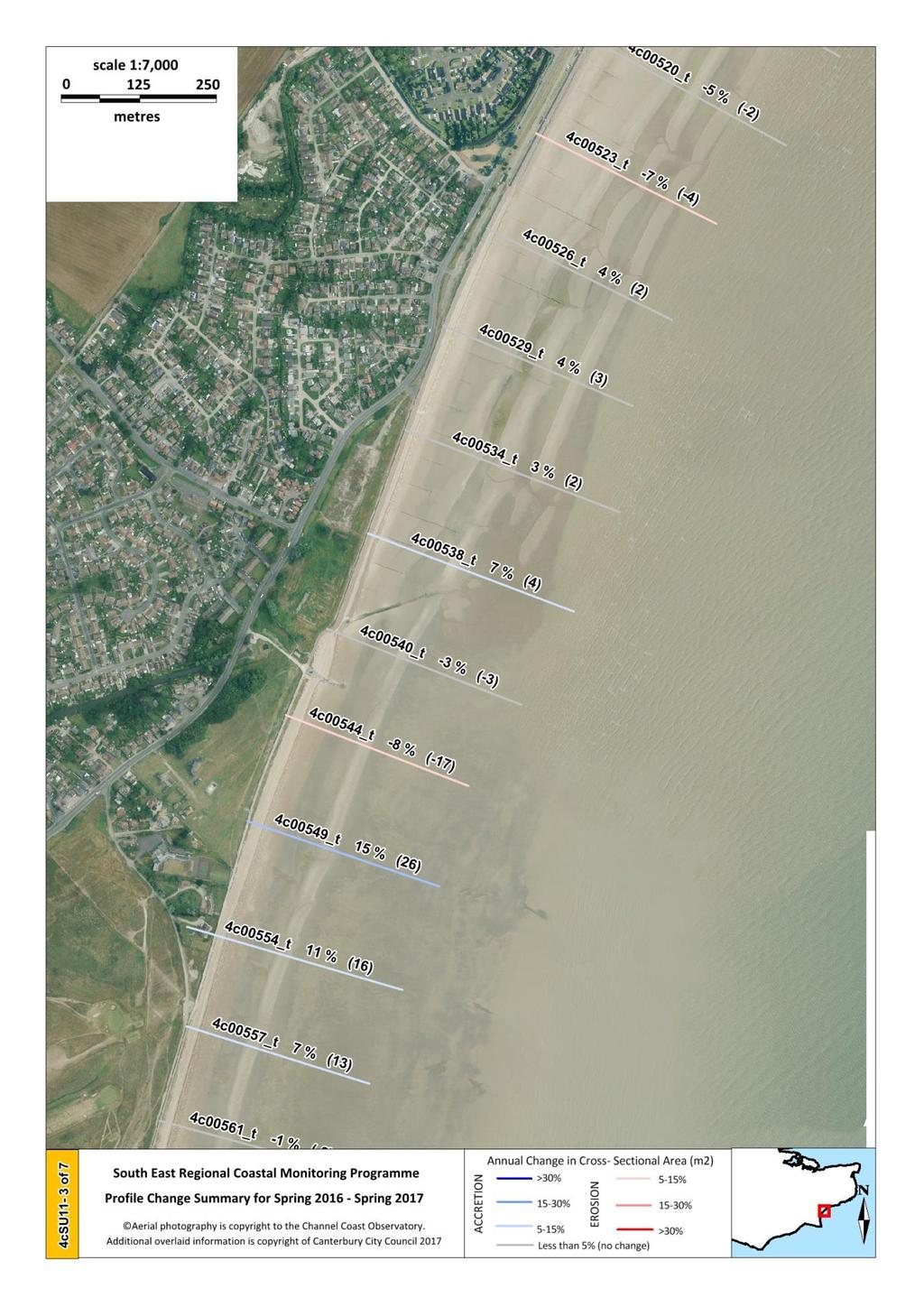
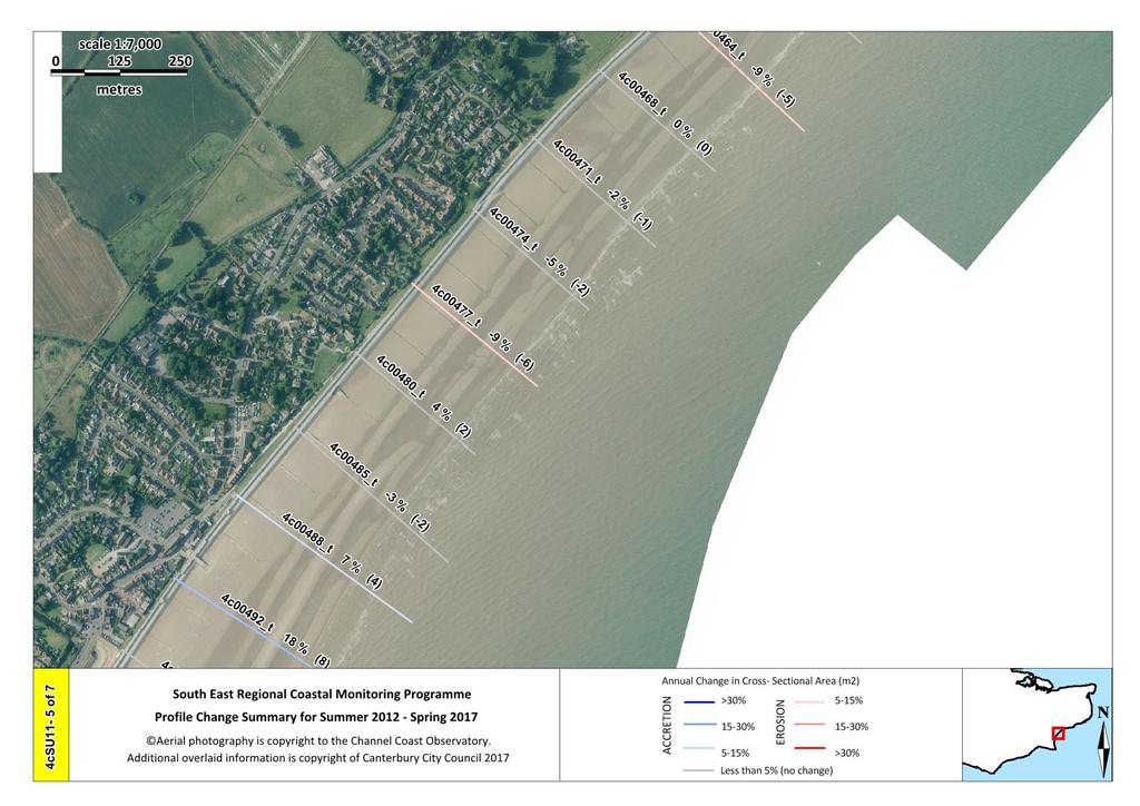
1 Survey Unit Location SMP Policy Author RT 4cSU11 Dymchurch Hold the Line Authorised by AS Published 19/12/2017 The 9km stretch of beach consists predominantly of shingle to the southwest of Dymchurch, and sand to the northeast. The frontage is divided by timber groynes at m spacing throughout almost all of its length with the exception of a terminal rock groyne situated at St. Mary s Bay. A large rock and concrete revetment extends from Martello Tower No. 25 to the eastern boundary of 4cSU11. Survey outcome: RBMP design levels have not been calculated for Dymchurch, so the Cross Sectional Area (CSA) cannot be assessed in relation to Standard of Protection (SoP), but the profile ranges have been plotted to show the current CSA in relation to historic levels. Please note that 2012 has been used as the baseline survey due to the completion of a concrete apron and a rock and stepped revetment in 2011 between Jesson Outfall and Hythe Ranges. Survey type Survey dates Most recent survey: Spring 2017 Comments Insignificant changes are observed on most profiles south of Jesson Outfall. Profile 4c00557 shows the greatest change with a loss of 11m 2 (-6%). Autumn to Spring Profile change 21/10/ /03/2017 Low level changes, both erosive and accretive are seen between Jesson Outfall and Martello Tower No.23. Profile 4c00488 gained 4m 2 (7%) and Profile 4c00464 lost 6m 2 (-10%). Most of the 13 profiles fronting the rock revetment show significant changes. Profile 4c00449 lost 10m 2 (-21%) and Profile 4c00416 gained 8m 2 (47%). Please note that some of the percentage changes are exaggerated by small CSAs and may only reflect a small absolute CSA change.
2 Survey type Survey dates Most recent survey: Spring 2017 Comments Low level changes, mainly accretive, are observed on profiles south of Jesson Outfall. 13 of the 21 profiles are accretive, with Profiles 4c00592 and 4c00549 showing gains of 23m 2 (17%) and 26m 2 (15%) respectively. Spring to Spring Baseline to Spring Spring to Summer 26/02/ /03/ /06/ /03/2017 Significant changes, mostly erosive, are shown between Jesson Outfall and Martello Tower No.23. Profile 4c00464 lost 11m 2 (- 17%). Significant changes, both erosive and accretive are observed on profiles fronting the rock revetment. Profile 4c00449 lost 17m 2 (-31%) and Profile 4c00416 gained 9m 2 (56%). Please note that some of the percentage changes are exaggerated by small CSAs and may only reflect a small absolute CSA change. Significant changes, mostly accretive, are seen on profiles south of Jesson Outfall. A significant number of profiles have gains of above 10%, with Profiles 4c00620 and 4c00549 gaining 19m 2 (13%) and 35m 2 (21%) respectively. Most profiles between Jesson Outfall and Martello Tower No.23 show significant accretion, with five consecutive profiles gaining at least 10% in beach material. Profile 4c00534 gained 13m 2 (24%). Profiles fronting the rock revetment show significant changes, with 11 of the 13 profiles accreting. Profiles 4c00449 and 4c00416 gained 19m 2 (100%) and 13m 2 (108%) respectively. Please note that some of the percentage changes are exaggerated by small CSAs and may only reflect a small absolute CSA change.
3 Survey type Survey dates Most recent survey: Spring 2017 Comments Summer to Autumn Baseline to Summer Summer to Summer Topographic difference model and Profile change

4
5

6
7
8

9
10
11
12
13

14
15
16
17
18

19
20
21
22
23
24

25
26
27 Interim Report - Appendix A: Explanation of the Historic Summary Chart The historic changes in Cross-Sectional Area (CSA) for each profile are summarised by identifying the historic highest and lowest CSA alongside the current CSA for each profile: FIGURE A1: PRESENTATION OF STANDARD OF PROTECTION AND TRIGGER LEVELS (A) HISTORIC VARIATION OF BEACH LEVELS (CSA) (B) SUMMARY OF DATA, PINK BAR CURRENT BEACH LEVEL, BLACK BARS HISTORIC HIGH AND LOW
.")
28 Appendix B: Profile Change Summary Changes along individual profiles for a range of timeframes are summarised in a series of thematic maps on the previous pages. The maps show the location of each beach profile, superimposed on aerial photography (note the lines have been extended for clarity). The name of the profile, the percentage change of beach material and the change in m 2 has been including upon the line, which is illustrated in Figure B1. FIGURE B1: PRESENTATION OF THE PROFILE CHANGE SUMMARY
Northern Sea Wall, Kent
 Northern Sea Wall, Kent The North Kent Shoreline Management Plan (SMP) defines management units along the North Kent coast ranging from Management Unit 4a - 1A at the Isle of Grain, to Management Unit
26 Coastal erosion and accretion
 26 Coastal erosion and accretion 26.1 Rate of erosion and accretion 26.2 Length of protected coastline 26.3 Volume of sand nourishment Fig. 26.1: Coastline dynamics of the South East Baltic region Key
Seaton to Seaton Hole SUMMARY OF PREFERRED PLAN RECOMMENDATIONS AND JUSTIFICATION
 Location reference: Policy Unit reference: Plan: Seaton to Seaton Hole 6a29 and 6a30 SUMMARY OF PREFERRED PLAN RECOMMENDATIONS AND JUSTIFICATION The large number of properties and assets at risk in the
Redcliffs Park Coastal inundation and coastal erosion
 48 Hereford Street Christchurch 8013 Attention: Deb Taylor Dear Deb 1 Introduction The (MoE) are looking to relocate Redcliffs School to a new school development at and are currently undertaking their
CHANGES IN BEACH SURFACE SEDIMENT COMPOSITION
 CHANGES IN BEACH SURFACE SEDIMENT COMPOSITION Compiled by Tamsin Watt. Edited by Rendel Williams and Cherith Moses 1 Aims...2 2 Introduction...2 3 Sites...2 4 Survey methodology...2 5 Analysis procedure...3
Draft exercise for share fair at Bozeman workshop only. This exercise is not ready for distribution. Please send helpful suggestions to
 Draft exercise for share fair at Bozeman workshop only. This exercise is not ready for distribution. Please send helpful suggestions to foleyd@plu.edu Figure list 1. Trailer photograph 2. Location map
SHORELINE MANAGEMENT PLAN FOR OWEN ANCHORAGE AND COCKBURN SOUND SHORELINE MONITORING PLAN
 SHORELINE MANAGEMENT PLAN FOR OWEN ANCHORAGE AND COCKBURN SOUND SHORELINE MONITORING PLAN CHAPTER EIGHT OF DOCUMENT: LONG-TERM SHELLSAND DREDGING, OWEN ANCHORAGE ENVIRONMENTAL MANAGEMENT PROGRAMME JUNE
Environment Bay of Plenty Ohope Beach system
 Environment Bay of Plenty 7 5. Ohope Beach system Environmental Publication 27/ NERMN Beach Profile Monitoring Environment Bay of Plenty 5..1 Ohope Spit (CCS 9) Discussion The site is located 2m to the
Appendix F Shoreline Interactions & Responses
 Appendix F Shoreline Interactions & Responses - Fi - Appendix F Shoreline Interactions & Responses APPENDIX F - CONTENTS Page F1 INTRODUCTION 1 F2 ASSESSMENT OF COASTAL DEFENCES 2 F2.1 Introduction 2 F2.2
Erosion Information Paper - Barrow, Alaska Current as of September 14, 2007
 U.S. Army Corps of Engineers ALASKA BASELINE EROSION ASSESSMENT Erosion Information Paper - Barrow, Alaska Current as of September 14, 2007 Community Information Barrow (BARE-row, a.k.a. Ukpeagvik), population
report Lake Taupo Shoreline Erosion Study
 report Lake Taupo Shoreline Erosion Study report Lake Taupo Shoreline Erosion Study Prepared for By Beca Infrastructure Ltd December 2006 3251438/TAA Rev F L2:66517 Table of Contents 1 Introduction...
SHORELINE AND BEACH PROCESSES: PART 2. Implications for Coastal Engineering
 SHORELINE AND BEACH PROCESSES: PART 2 Implications for Coastal Engineering Objectives of the lecture: Part 2 Show examples of coastal engineering Discuss the practical difficulties of ocean engineering
Coastal Management on the Isle of Wight
 Coastal Management on the Isle of Wight Setting the scene The Isle of Wight has 65 miles of spectacular coastline, 28 miles of which are designated Heritage Coast. This varied coastline is one of the Island
Beach Profile Changes using RTK GPS : A Case Study Maizati Binti Mohamed Amin 1, a, Radzuan Sa ari 1, b, Muhammad Azril Hezmi 1, c
 Beach Profile Changes using RTK GPS : A Case Study Maizati Binti Mohamed Amin 1, a, Radzuan Sa ari 1, b, Muhammad Azril Hezmi 1, c 1 Faculty of Civil Engineering, Universiti Teknologi Malaysia, Malaysia
AS & A2 Geography for OCR. Tailored Courses. Slapton Ley
 AS & A2 Geography for OCR Tailored Courses Slapton Ley Please visit http://www.field-studies-council.org/outdoorclassroom/geography/aqa/ for alternative A-level AQA programmes OVERVIEW Since the assessment
Map Introduction: South Uist Map 1
 96 Map Introduction: Map This map section covers part of the south coast of, including the head of the causeway which links the island to Eriskay. It extends from South Glen Dale to Taobh a'caolas. There
DESIGN ENGINEERING ANALYSIS FOR TERMINAL GROIN LENGTH
 APPENDIX F DESIGN ENGINEERING ANALYSIS FOR TERMINAL GROIN LENGTH (Prepared by Olsen Associates, Inc.) DRAFT Environmental Impact Statement Village of Bald Head Island Shoreline Protection Project Brunswick
Assessment in Mathematics Year 6 and KS3. Nigel Bufton MATHSEDUCATIONAL LTD and the London Borough of Camden
 Year 6 Number Identify common factors, common multiples, and prime, square and cube numbers; use negative numbers Calculate mentally with mixed operations; use formal written methods to multiply and divide
Shoreline Mapping & Erosion Patterns. Julia Knisel Julia Knisel Coastal Shoreline & Floodplain Manager
 Shoreline Mapping & Erosion Patterns Along the Massachusetts Coast Julia Knisel Julia Knisel Coastal Shoreline & Floodplain Manager CZM Shoreline Change Project Timeline 1989: produced coast wide maps
BEFORE THE ENVIRONMENTAL PROTECTION AUTHORITY AT WELLINGTON
 BEFORE THE ENVIRONMENTAL PROTECTION AUTHORITY AT WELLINGTON IN THE MATTER of the Exclusive Economic Zone and Continental Shelf (Environmental Effects) Act 2012 (EEZ Act) AND IN THE MATTER BETWEEN AND AND
Scotland s centre of expertise for waters. Dynamic Coast - National Coastal Change Assessment: Defence Asset Database
 Scotland s centre of expertise for waters Dynamic Coast - National Coastal Change Assessment: Defence Asset Database Scotland s centre of expertise for waters Published by CREW Scotland s Centre of Expertise
SHADOW STUDY REPORT REGARDING
 SHADOW STUDY REPORT REGARDING an APPLICATION TO REDEVELOP Three 6 Storey Condominiums Regional Road 25 (Ontario Street) and Britannia Road Milton, Ontario KNYMH FILE # 17030 Prepared by: Krista Lilley
Annual transport rates at two locations on the fore-slope.
 Sediment Transport by Currents Fore-slope Sediment transport rates and sediment concentrations were computed from the hydrodynamic model runs as well as from direct measurements of current velocities at
GY 301: Geomorphology Lab 3: Introduction to Topographic Maps; Coastal Geomorphology
 Name: Raw score: /65 Percentage: /100% GY 301: Geomorphology Your Task: Today s lab is your first opportunity to closely examine topographic maps. You will be asked to answer various questions about map
Virginia Shoreline Mapping Tools
 Virginia Shoreline Mapping Tools December 15, 2017 Karen Duhring Center for Coastal Resources Management Virginia Institute of Marine Science College of William & Mary Virginia Shoreline Mapping Tools
Coastal Trends Report. North East Norfolk and North Suffolk (Kelling Hard to Lowestoft Ness) RP033/N/2013
 RP033/N/2013") Coastal Trends Report North East Norfolk and North Suffolk (Kelling Hard to Lowestoft Ness) RP033/N/2013 June 2013 We are the Environment Agency. We protect and improve the environment and make it a better
Coastal Trends Report North East Norfolk and North Suffolk (Kelling Hard to Lowestoft Ness) RP033/N/2013 June 2013 We are the Environment Agency. We protect and improve the environment and make it a better
Term Knowledge Using and applying Grade Criteria Autumn 1 Assessment window October Natural hazards pose major risks to people and property.
 Assessment Schedule Year 9 2015/6 Term Knowledge Using and applying Grade Criteria Autumn 1 Assessment window October 2015 3.1.1.2 Tectonic Natural hazards pose major risks to people and property. Definition
Project No India Basin Shadow Study San Francisco, California, USA
 Project No. 432301 India Basin Shadow Study San Francisco, California, USA Numerical Modelling Studies 04 th June 2018 For Build Inc. Report Title: India Basin Shadow Study San Francisco, California, USA
Annual Update Student Learning Outcomes Packet
 III. Annual Update Student Learning Outcomes Packet Quality and Innovation in the Program and Curriculum Review Please refer to the current data set for your program found at: http://research.hancockcollege.
Practice: Planning and Carrying out Investigations Crosscutting Concept: Cause and Effect
 4-ESS2-1 Make observations and/or measurements to provide evidence of the effects of weathering or the rate of erosion by water, ice, wind, or vegetation. [Clarification statement: Examples of variables
Highland Lake Bathymetric Survey
 Highland Lake Bathymetric Survey Final Report, Prepared For: The Town of Highland Lake 612 Lakeshore Drive Oneonta, AL 35121 Prepared By: Tetra Tech 2110 Powers Ferry Road SE Suite 202 Atlanta, GA 30339
U.S. Army Corps of Engineers - Buffalo District
 A REVISED GEOMORPHIC, SHORE PROTECTION AND NEARSHORE CLASSIFICATION OF THE LAKE ERIE, LAKE ONTARIO, NIAGARA RIVER AND ST. LAWRENCE RIVER SHORELINES LOWER GREAT LAKES EROSION STUDY Submitted By: Contract
Coastal Processes 101 & The Regs. Greg Berman (Woods Hole Sea Grant & Cape Cod Cooperative Extension)
") Coastal Processes 101 & The Regs Greg Berman (Woods Hole Sea Grant & Cape Cod Cooperative Extension) March 26, 2019 Coastal Processes 101 & The Regs Outline: ~15 min talk Coastal Processes What is Erosion?
Coastal Processes 101 & The Regs Greg Berman (Woods Hole Sea Grant & Cape Cod Cooperative Extension) March 26, 2019 Coastal Processes 101 & The Regs Outline: ~15 min talk Coastal Processes What is Erosion?
Coastal Trends Report. North Norfolk (Old Hunstanton to Kelling) RP028/L/2011 October Title here in 8pt Arial (change text colour to black) i
 RP028/L/2011 October Title here in 8pt Arial (change text colour to black) i") Coastal Trends Report North Norfolk (Old Hunstanton to Kelling) RP028/L/2011 October 2012 Title here in 8pt Arial (change text colour to black) i We are the Environment Agency. We protect and improve the
Coastal Trends Report North Norfolk (Old Hunstanton to Kelling) RP028/L/2011 October 2012 Title here in 8pt Arial (change text colour to black) i We are the Environment Agency. We protect and improve the
Unit 7.2 W.E.D. & Topography Test
 Name: Score: Unit 7.2 W.E.D. & Topography Test 1. 2. 3. 4. 5. 6. 7. 8. 9. 10. 11. 12. 13. 14. 15. 16. 17. 18. 19. 20. 21. 22. 23. 24. 25. 1. The formation of mountains is due mainly to while the destruction
Community Erosion Assessment Napakiak, Alaska 15 January 2008
 1. Community: Napakiak, Alaska Community Erosion Assessment Napakiak, Alaska 15 January 2008 Figure 1: Napakiak Location & Vicinity Map 2. Community Profile Summary: Napakiak is a 2 nd class city of 378
These maps make the idea of elevations and contours more tangible follow any of the brown-line contours; they should form a level path.
 Geology 101 Name(s): Lab 1: Maps and geologic time Note: On all labs, you may work in small groups. You may turn in one lab for all of the group members; make sure that everyone who should get credit is
How to Read These Flood Hazard Maps
 How to Read These Flood Hazard Maps The United States Geological Survey (USGS) has developed the Coastal Storms Modeling System (CoSMoS), which projects coastal flooding and erosion from coastal storms,
Looking after Lyme Regis
 Looking after Lyme Regis Lyme Regis sits on one of the most unstable stretches of coastline in the country. The highly active and unstable nature of the land which Lyme Regis is built upon can easily be
6. SURVEY MAPS OF THE ISLE OF ARRAN MAP 1: DRUMADOON POINT TO AIRD NAN RON
 6. SURVEY MAPS OF THE ISLE OF ARRAN MAP 1: DRUMADOON POINT TO AIRD NAN RON Hinterland Geology and Coastal Geomorphology: Both Permian sandstone and Triassic mudstones are represented in this coastal section.
Investigation IV: Seasonal Precipitation and Seasonal Surface Runoff in the US
 Investigation IV: Seasonal Precipitation and Seasonal Surface Runoff in the US Purpose Students will consider the seasonality of precipitation and surface runoff and think about how the time of year can
Introduction to Google Earth
 Introduction to Google Earth Name Goals 1. To become proficient at using the basic features of Google Earth. 2. To recognize differences in coastal features between the east and west coast of North America.
Attachment E: CADP Design Shadow Analysis
 Attachment E: CADP Design Shadow Analysis June 6, 2016 TO: Don Lewis San Francisco Planning Department 1650 Mission Street, Suite 400 San Francisco, CA 94103 SUBJECT: 2060 Folsom Street 17 th & Folsom
Monitoring Coastal Change after the Tsunami in Thailand
 IOP Conference Series: Earth and Environmental Science OPEN ACCESS Monitoring Coastal Change after the Tsunami in Thailand To cite this article: W Pantanahiran 2014 IOP Conf. Ser.: Earth Environ. Sci.
REPORT. Coastal Inundation Hazard Zone Mapping. Addendum to Coastal Protection Areas Re-assessment Stage Two
 REPORT Coastal Inundation Hazard Zone Mapping Addendum to Coastal Protection Areas Re-assessment Stage Two Prepared for Prepared by Date Job Number 851833 Distribution: (FILE) 1 copy 1 copy Table of contents
2.2.7 Backbarrier flats
 FIGURE 24. VERTICAL PHOTOGRAPH SHOWING THE DEVELOPMENT OF SMALL PARABOLIC DUNES FROM BLOWOUTS IN A LARGE RELICT FOREDUNE NORTHWEST OF HUNTER'S CREEK. PHOTOGRAPH COURTESY OF CAR'T'ER HOLT HARVEY FORESTS
East Head, West Wittering and Cakeham: Interpretation of beach changes
 East Head, West Wittering and Cakeham: Interpretation of beach changes 2004-09 Draft Report to: Chichester District Council and East Head Coastal Issues Advisory Group Malcolm Bray University of Portsmouth
Client: Environment Agency Project: Regional Shingle Sediment Budget Report Oldstairs Bay to Sandwich Bay
 Engineering Services Military Road Canterbury CT1 1YW Client: Environment Agency Project: Regional Shingle Sediment Budget Report Canterbury City Council Strategic Monitoring Military Road Canterbury
Poole and Christchurch Bays Shoreline Management Plan Review Sub-cell 5f Section 4. Policy Development Zone 1
 Poole and Christchurch Bays Shoreline Management Plan Review Sub-cell 5f Section 4. Policy Development Zone 1 Bournemouth Borough Council 2011 Report V4 9T2052 A COMPANY OF HASKONING UK LTD. COASTAL &
GCSE. Edexcel GCSE Geography A (1312 4H) Summer Mark Scheme (Results)
 Summer Mark Scheme (Results)") GCSE Edexcel GCSE Geography A (1312 4H) Summer 2006 Mark Scheme (Results) Question 1 a) Study Figure 1a. It is a sketch map of Blandford Forum. Also study Photographs A, B and C in the Map and Photography
GCSE Edexcel GCSE Geography A (1312 4H) Summer 2006 Mark Scheme (Results) Question 1 a) Study Figure 1a. It is a sketch map of Blandford Forum. Also study Photographs A, B and C in the Map and Photography
Erosion Information Paper - South Naknek, Alaska Current as of November 14, 2007
 U.S. Army Corps of Engineers ALASKA BASELINE EROSION ASSESSMENT Erosion Information Paper - South Naknek, Alaska Current as of November 14, 2007 Community Information South Naknek (NACK-neck), originally
Map 9: Ayrshire Coast: Stevenston Pier to Barassie Map Content Descriptions
 Map 9: Ayrshire Coast: Stevenston Pier to Barassie Map Content Descriptions 1. Built Heritage and Archaeology A total of thirteen sites were recorded in the area covered by Map 9. Of these five were previously
Coastal Processes and Shoreline Erosion on the Oregon Coast, Cascade Head to Cape Kiwanda
 State of Oregon Department of Geology and Mineral Industries Vicki S. McConnell, State Geologist Open File Report OFR O-04-11 Coastal Processes and Shoreline Erosion on the Oregon Coast, Cascade Head to
Addendum to the Essex and South Suffolk Second Generation Shoreline Management Plan
 Addendum to the Essex and South Suffolk Second Generation Shoreline Management Plan September 2012 CONTENTS 1. Introduction 1 2. Changes in saltmarsh habitat 1 3. Preferred managed realignment policy options
Managing and adapting to coastal erosion on the West Coast: Ngakawau & Hector
 Managing and adapting to coastal erosion on the West Coast: Ngakawau & Hector NIWA Client Report: HAM2007-007 January 2007 NIWA Project: EVL07201 Managing and adapting to coastal erosion on the West Coast:
Factors That Shape Places. Sackville North
 Factors That Shape Places Sackville North Stage 3 Geography As urban Sydney sprawls in all directions, the North West is changing dramatically. This Geographical Inquiry will focus on the connections between
Coastal Inlets Research Program US Army Corps of Engineers Engineering Research and Development Center
 Coastal Inlets Research Program US Army Corps of Engineers Engineering Research and Development Center Site of Moriches Inlet Nov. 1951 Julie Dean Rosati and Nicholas C. Kraus, CIRP Program Manager Shinnecock
BUTE MAP 2: ARDMALEISH POINT to ARDBEG
 BUTE MAP 2: ARDMALEISH POINT to ARDBEG Hinterland Geology and Coastal Geomorphology: Dalradian schists continue to dominate this coastal region. The Kames Bay area is dominated by Dunoon Phylites which
Map 12: Ayrshire Coast: Doonfoot Beach to Dunure Map Content Descriptions
 Map 12: Ayrshire Coast: Doonfoot Beach to Dunure Map Content Descriptions 1. Built Heritage and Archaeology A total of twenty three sites were located in the area covered by Map 12. Of these seventeen
1. The coastal system. Constructive and destructive waves, Tides Sediment sources and cells.
 Features of the Coastal System INPUTS PROCESSES OUTPUTS Sediment 95% = 5% = 5% = 1. The coastal system Constructive and destructive waves, Tides Sediment sources and cells. The Coastal System Identify
Hurricane Harvey: Texas Coastal Erosion Hot Spot Analysis
 Hurricane Harvey: Texas Coastal Erosion Hot Spot Analysis Texas ASBPA Symposium April 24, 2018 Alan Johnson, FEMA Chris Levitz, Compass Agenda Introduction Hurricane Harvey Erosion Hot Spot Analysis Purpose
COASTAL DYNAMICS VIRTUAL FIELD TRIP, NORTHEAST FLORIDA. Joann Mossa Department of Geography University of Florida
 COASTAL DYNAMICS VIRTUAL FIELD TRIP, NORTHEAST FLORIDA Joann Mossa Department of Geography University of Florida WHERE ARE WE GOING? In NE Florida (Flagler and St. Johns County, south of St. Augustine),
Removal of riverbank protection along the River Rhine (the Netherlands)
") RR 2004 3rd European Conference on River Restoration RIVER RESTORATION 2004 Zagreb, Croatia, 17-21 May 2004 Removal of riverbank protection along the River Rhine (the Netherlands) L.J. Bolwidt, H.E.J.
RR 2004 3rd European Conference on River Restoration RIVER RESTORATION 2004 Zagreb, Croatia, 17-21 May 2004 Removal of riverbank protection along the River Rhine (the Netherlands) L.J. Bolwidt, H.E.J.
225 Bush Street Suite 1700 San Francisco, CA phone fax
 225 Bush Street Suite 1700 San Francisco, CA 94104 415.896.5900 phone 415.896.0332 fax www.esassoc.com memorandum date July 29, 2009 to from subject Craig Nikitas, San Francisco Planning Department Daniel
Coastline Changes in Mantanani Besar Island, Sabah, Malaysia
 Transactions on Science and Technology, 3(2-2), 401-406, 2016 ISSN: 2289-8786 Coastline Changes in Mantanani Besar Island, Sabah, Malaysia Russel Felix Koiting*, Ejria Saleh, John Madin, Fazliana Mustajap
Using Remote Piloted Aircraft for Seawall Condition Assessment
 Using Remote Piloted Aircraft for Seawall Condition Assessment Moreton Bay Regional Council Shamim Yazdani Senior Engineer - Stormwater Planning DJI Industries Phantom FC-40 remotely-piloted aircraft 1
APPENDIX N View Impact & Shadow Analysis
 Permit Application Document TABLE OF CONTENTS 1.0 VIEW IMPACT ANALYSIS... 2 1.1 Overview... 2 1.2 View Impact Assessment Methodology... 2 1.3 Site Description... 3 1.4 Comparative Structure Heights...
Long-term estuary processes and morphological change
 Long-term estuary processes and morphological change Professor Ken Pye with contributions from Dr. Simon Blott and Dr. Daphne van der Wal Department of Geology Available top-down methods relying on data
Holderness Erosion and Evolution of the Spurn Peninsula
 Holderness Erosion and Evolution of the Spurn Peninsula Prof. Ken Pye and Dr. Simon Blott Kenneth Pye Associates Ltd. Outline of the Presentation Overview of historical erosion trends Effects of coast
SHORT AND LONG TERM IMPACTS OF THE CONSTRUCTION OF COAST DEFENCES ON COASTAL EROSION
 SHORT AND LONG TERM IMPACTS OF THE CONSTRUCTION OF COAST DEFENCES ON COASTAL EROSION by 1, Kevin Burgess 1 and Ben Hamer 1 1 Halcrow Group Ltd, Burderop Park, Swindon, Wiltshire, SN4 0QD Abstract: Significant
SAVANNAH HARBOR EXPANSION BANK EROSION STUDY UPDATE
 CESAS-EN-GS SAVANNAH HARBOR EXPANSION BANK EROSION STUDY UPDATE GEOTECHNICAL AND HTRW BRANCH SOILS SECTION CITY FRONT, BIGHT SECTION, FORT PULASKI & NORTH TYBEE ISLAND GEORGIA 23 June 2011 CESAW-TS-EG
Beatrice Offshore Wind Farm: Transmission Cable Landfall Impact Assessment
 Beatrice Offshore Windfarm Ltd Beatrice Offshore Wind Farm: Transmission Cable Landfall Impact Assessment Report R.1886 January 2012 Beatrice Offshore Windfarm Ltd Beatrice Offshore Wind Farm: Date: January
GCSE. Edexcel GCSE Geography A (1312 2F) Summer Mark Scheme (Results)
 Summer Mark Scheme (Results)") GCSE Edexcel GCSE Geography A (1312 2F) Summer 2006 Mark Scheme (Results) Question 1 a) Look at Figure 1. It is a sketch map of Blandford Forum. Also look at Photographs A, B and C in the Map and Photograph
GCSE Edexcel GCSE Geography A (1312 2F) Summer 2006 Mark Scheme (Results) Question 1 a) Look at Figure 1. It is a sketch map of Blandford Forum. Also look at Photographs A, B and C in the Map and Photograph
Yoshinori KAWAMURA, Oriental Consultants Global Co., Ltd.
 Landslides along National Roads in Central Highland in Sri Lanka: Review on Current Situation and Suggestion for Further Development of Landslide Mitigation along Highways in Sri Lanka Yoshinori KAWAMURA,
Coastal Trends Report. Lincolnshire (Subcells 2b-c - Grimsby to Gibraltar Point) RP007/L/2008 July 2008
 RP007/L/2008 July 2008") Coastal Trends Report Lincolnshire (Subcells 2bc Grimsby to Gibraltar Point) RP007/L/2008 July 2008 Title here in 8pt Arial (change text colour to black) i We are the Environment Agency. We protect and
Coastal Trends Report Lincolnshire (Subcells 2bc Grimsby to Gibraltar Point) RP007/L/2008 July 2008 Title here in 8pt Arial (change text colour to black) i We are the Environment Agency. We protect and
MEMORANDUM FOR SWG
 MEMORANDUM FOR SWG-2007-1623 Subject: Jurisdictional Determination (JD) for SWG-2007-1623 on Interdunal Wetlands Adjacent to Traditional Navigable Waters (TNWs) Summary The U.S. Environmental Protection
 Page 1 of 9 Name: Base your answer to the question on the diagram below. The arrows show the direction in which sediment is being transported along the shoreline. A barrier beach has formed, creating a
Scenarios for the NI coast in the 21 st Century
 Scenarios for the NI coast in the 21 st Century Prof Julian Orford Geography, Archaeology & Palaeoecology Queen s University, Belfast Challenging perspective Living by the coast is good for your health!
Coastal Trends Report. North Norfolk (Old Hunstanton to Kelling) RP005/N/2007 November Title here in 8pt Arial (change text colour to black) i
 RP005/N/2007 November Title here in 8pt Arial (change text colour to black) i") Coastal Trends Report North Norfolk (Old Hunstanton to Kelling) RP005/N/2007 November 2007 Title here in 8pt Arial (change text colour to black) i We are the Environment Agency. We protect and improve
Coastal Trends Report North Norfolk (Old Hunstanton to Kelling) RP005/N/2007 November 2007 Title here in 8pt Arial (change text colour to black) i We are the Environment Agency. We protect and improve
Beaches Carrying Capacity Assessment in Kuwait Based on Photointerpretation and Ground Survey
 Technical Session: TS 07B - GIS Applications (Number # 5463) Beaches Carrying Capacity Assessment in Kuwait Based on Photointerpretation and Ground Survey Prof. Mohamed AIT BELAID Shaikh Hamad Bin Khalifa
Cambridge International Examinations Cambridge International General Certificate of Secondary Education
 Cambridge International Examinations Cambridge International General Certificate of Secondary Education *4928827220* GEOGRAPHY 0460/42 Paper 4 Alternative to Coursework October/November 2015 Candidates
8.1 Attachment 1: Ambient Weather Conditions at Jervoise Bay, Cockburn Sound
 8.1 Attachment 1: Ambient Weather Conditions at Jervoise Bay, Cockburn Sound Cockburn Sound is 20km south of the Perth-Fremantle area and has two features that are unique along Perth s metropolitan coast
SCOUR AND EROSION ALONGSIDE BANK PROTECTION WORK: CASE STUDIES FROM BANGLADESH
 SCOUR AND EROSION ALONGSIDE BANK PROTECTION WORK: CASE STUDIES FROM BANGLADESH KNUT OBERHAGEMANN Northwest Hydraulic Consultants Lt. 4823 99 th Street Edmonton, Alberta T6E 4Y1, Canada ABDUN NOOR Bangladesh
Coastal Processes Study: East Lane, Bawdsey, Suffolk Final Report
 Table 5.5: Calculated theoretical breaking wave height associated with MHWS still water level Wave Period (s) Breaking Wave Height (m) Wave Crest Level (m AOD) 10.6 1.36 1.66 8.0 1.33 1.64 6.0 1.28 1.59
The use of MIKE21 to study the. barrier beach system of Inner Dingle Bay, Co. Kerry, Ireland. Dr. Michael O Shea Malachy Walsh and Partners
 The use of MIKE21 to study the morphodynamic evolution of the mid-bay barrier beach system of Inner Dingle Bay, Co. Kerry, Ireland Dr. Michael O Shea Malachy Walsh and Partners Contents Why Study Morphodynamics
Linear Equations & Inequalities Definitions
 Linear Equations & Inequalities Definitions Constants - a term that is only a number Example: 3; -6; -10.5 Coefficients - the number in front of a term Example: -3x 2, -3 is the coefficient Variable -
APPENDIX 1. Geotechnical Information and Analysis. Pacific Aggregates Inc. and Pacific Clay Products July 13, 2011 RP112 Reclamation Plan
 Pacific Aggregates Inc. and Pacific Clay Products July 13, 2011 RP112 Reclamation Plan APPENDIX 1 Geotechnical Information and Analysis PA02_RP112-RecPlan-Resub_FNL.docx SESPE Consulting, Inc. June 27,
Appendix C - Geotechnical Report. Landmark Consultants, Inc.
 Appendix C - Geotechnical Report Landmark Consultants, Inc. LCI Report No. LP18128 Fault Map Regional Review of the current Alquist-Priolo Earthquake Fault Zone maps (CGS, 2000a) indicates that
Coastal Morphology Report
 Coastal Morphology Report Southwold to Benacre Denes (Suffolk) RP016/S/2010 March 2010 Title here in 8pt Arial (change text colour to black) i We are the Environment Agency. We protect and improve the
Connecticut Coastal Management Program
 Connecticut Coastal Management Program Fact Sheet for SHORELINE FLOOD AND EROSION CONTROL STRUCTURES What are Shoreline Flood and Erosion Control Structures? The Connecticut General Statutes (CGS) define
DESIGN ENGINEERING ANALYSIS FOR TERMINAL GROIN LENGTH
 APPENDIX I DESIGN ENGINEERING ANALYSIS FOR TERMINAL GROIN LENGTH (Prepared by Olsen Associates, Inc.) Final Environmental Impact Statement Village of Bald Head Island Shoreline Protection Project Brunswick
7 The Hawke's Bay Littoral Cells: Processes,
 7 The Hawke's Bay Littoral Cells: Processes, Erosion Problems and Management Strategies 7.1 INTRODUCTION Coasts are commonly divided into what is termed "littoral cells", representing a stretch of beach
An environmentally sensitive erosion control technique in the Mekong River Delta: 10 years on
 7 th Australian Stream Management Conference - Full Paper An environmentally sensitive erosion control technique in the Mekong River Delta: 10 years on John Tilleard 1, Tony Ladson 2 1 Moroka Pty Ltd,
The student will plan and conduct investigations in which
 ES.1 The student will plan and conduct investigations in which a) volume, area, mass, elapsed time, direction, temperature, pressure, distance, density, and changes in elevation/depth are calculated utilizing
The "Geo-Information System Coast Mecklenburg-Vorpommern"
 The "Geo-Information System Coast Mecklenburg-Vorpommern" Lars Tiepolt State Office for Environment and Nature Rostock, Germany Abstract The Division Coast of the State Office for Environment and Nature
SHADOW STUDY REPORT REGARDING an APPLICATION TO REDEVELOP 6 Storey Condominium Louis Saint Laurent Ave & Leger Way Milton, Ontario
 SHADOW STUDY REPORT REGARDING an APPLICATION TO REDEVELOP 6 Storey Condominium Louis Saint Laurent Ave & Leger Way Milton, Ontario KNY FILE # 15145 Prepared by: Brad Ferguson & Wayne Harrison KNYMH INC.
Indigenous technical knowledge for bank erosion and flood management
 2017 APEC Typhoon Symposium, May 2 4, 2017, GIS NTU Convention Center, Taipei Indigenous technical knowledge for bank erosion and flood management Hao Zhang 1) and Hajime Nakagawa 2) 1) Associate Professor,
Coimisiún na Scrúduithe Stáit State Examinations Commission
 Coimisiún na Scrúduithe Stáit State Examinations Commission LEAVING CERTIFICATE EXAMINATION GEOGRAPHY HIGHER LEVEL SAMPLE PAPER N.B. Remember to return this paper with your answer-book. Otherwise, marks
Beach Sediment Tracer Study Beach Tracer Report for Portsmouth & Hayling Island Frontage
 Beach Sediment Tracer Study 2010-2012 Beach Tracer Report for Portsmouth & Hayling Island Frontage Introduction The SCOPAC Sediment Transport Study (2004) identified several limitations in the current
The environmental impact of marina development on adjacent beaches: a case study of the Herzliya marina, Israel
 Applied Geography 21 (2001) 145 156 www.elsevier.com/locate/apgeog The environmental impact of marina development on adjacent beaches: a case study of the Herzliya marina, Israel Micha Klein *, Dov Zviely