Introduction to RADI,CAS
|
|
|
- Quentin Buck Harrison
- 5 years ago
- Views:
Transcription

1 Introduction to RADI,CAS LIU Jie Director of International Cooperation Office June 22, 2016 Beijing China
2 About RADI The RADI is an independent research institute affiliated to the Chinese Academy of Sciences for remote sensing and digital Earth. Mission Reception, processing, archiving and dissemination of remotely sensed data. Research and development on supporting new earth observation system, improving remote sensing data processing and analytical methodologies, and promoting multidisciplinary applications based on earth observation technology. Theoretical and technological research into key issues concerning Geo-spatial Information science and Digital Earth Platform. They are involved together in solving some environmental problems at the global, regional and national scales.

3 Organization


4 Staff 6 research departments, 36 research units 1200 employees and students 303 senior scientists & technicians, 102 full professor 37 - average age and Ph.D % 3 CAS Member, 4 awardees of Thousand Talents Program 90 graduate supervisors, including 45 doctoral supervisor 4 International organizations


5 Campus Adv.-tech. Camp. Olympic Vil. Camp. Miyun Station Sanya Station Kashi Station L.X. Airport
6 RADI s Four Core Competitive Competences
:LANDSAT-5 LANDSAT-7 France(SPOT Image):SPOT-1 SPOT-2 SPOT-4 SPOT-5")
7 1. Spaceborne-airborne-ground remote sensing data acquiring and processing capacity. Foreign satellites China s satellites Optical satellites Radar satellites Optical satellites Radar satellites The US(USGS):LANDSAT-5 LANDSAT-7 France(SPOT Image):SPOT-1 SPOT-2 SPOT-4 SPOT-5 India(ISRO):RESOURCESAT-1(IRS-P6) Thailand(GISTDA):THEOS European Space Agency(ESA):ERS-1 ERS-2 ENVISAT Canada(MDA):RADARSAT-1 RADARSAT-2 China-Brazil Earth Resource Satellites: CBERS-01 CBERS-02 CBERS-02B Environment disaster reduction satellites: HJ-1A HJ-1B Resource satellites:zy-02c ZY-3 SJ-9 satellites:sj-9a SJ-9B High-resolution satellite: GF-1 Environment disaster reduction satellites: HJ-1C China Remote Sensing Satellite Ground Station a member of the Landsat Ground Station Operations Working Group, boasts one of the world's highest capacities for receiving, processing, and distributing satellite data. With over 3.3 million scenes of satellite data filed since 1986, it is regarded as the largest Earth observation satellite data archive in China.


8 SatSee Technology Low-cost virtual ground station for disaster mitigation 2Mbits internet connection two computers and a large monitor or TV screen Distributing real time quick-look imagery of high resolution satellite real time quick-look imagery SatSee System Tracking Satellite Viewer RADI s three stations receive data from satellites covering 70% of Asia. Installed in Kirghizstan Mongolia, Cambodia,etc


9 1. Spaceborne-airborne-ground remote sensing data acquiring and processing capacity Two Remote Sensing Aircrafts Round-the-clock flying capability; Equipped with various airborne remote sensors, and can be used to test newlydeveloped advanced sensors; Provides high-resolution satellite data. Two new Remote Sensing Aircrafts Equipped with 10 state-of-the-art remote sensors: visible, infrared, and microwave remote sensors and a high-performance data processing system. Cessna Citation S/II Max Altitude Max Range Max Speed Technical Index 13,000 m 3,300 km 746 km/h New Airplane Airborne atmospheric laser radar Digital CCD camera Airborne whiskbroom imaging spectrometer (0.45 m-12.5 m) Airborne 3-D light detection and ranging Airborne X-band interferometry SAR Airborne pushbroom imaging spectrometer (0.45 m-2.5 m)


10 2. Remote sensing science and spatial information research capacity Building All-band remote sensing mechanism simulation system, providing remote sensing theory and key technologies for Earth system key factors; Erecting an advanced space remote sensing payload verification system, testing the new sensors for a variety of satellites, including satellite for water cycle observation, satellite-borne Lidar, China-Brazil Earth Resources Satellite and hyperspectral satellites. Building up a Earth observation system simulation platform, providing planning support national major special projects. Major Special Projects Spatial Infrastructure for Natural Disasters National Spatial Infrastructure Plan 天 空 地 立体数据获取系统 应急特批 社会服务 国家自然灾害空间信息综合集成服务系统 共享 专项服务 部门 ( 区域 行业 ) 灾害空间信息应用系统


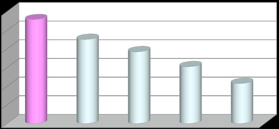
11 发文量 ( 篇 ) Four core competitive competences 2. Remote sensing science and spatial information research capacity Spaceborne-airborne-ground Earth observation system for high quality research 1 st place: SCI-cited Papers in the Field of RS ( ) 年 美国中国德国意大利加拿大法国印度英国西班牙澳大利亚荷兰日本巴西瑞士芬兰 Number of Paper Top 5 in the world RADI NASA-GSFC DLR NASA-JPL DG-UMD

12 3. Digital Earth science platform and global environmental resources information analytical ability CAS Key Laboratory of Digital Earth Science Developing the first Digital Earth Science Platform and establishing global resource-environmental spatial information system on the basis of the platform and the concept of new generation Digital Earth ; Developing more than 30 spatial information products of global resource-environment, being adopted by many national information release platforms. 12


13 Digital Earth Applications Global Climate Change Digital City Food and Water Insecurity Natural Disaster Energy Resources 30 categories of products, including land, ocean, atmosphere, urban construction; Time-space scale: long-time series in global and regional scales.


14 CropWatch System Conducting global agricultural monitoring by developing monitoring index system with multi-scale and multiple time-space resolution to support decision-making. Global estimation of four staple crops in 2013 multi-scale: global, intercontinental, major producing countries, province/state Full coverage: 31 major crop producing countries in the world It has been used by more than 30 users across the country, with worldwide attention CropWatch Bulletin


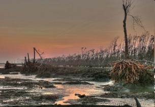
15 Disasters monitoring and damage assessment Soon after the Lushan earthquake, RADI was the FIRST to obtain remote sensing images of the disaster area and rapidly provided the authorities with relevant remote sensing data and disaster analysis. Aerial remote sensing images produced by RADI were used at a State Council meeting chaired by Premier LI Keqiang on earthquake disaster mitigation on April 22, In April 2013, Vice Premier Liu Yandong praised RADI for its rapid offering of highresolution images for Lushan earthquake disaster reduction.
16 International Cooperation
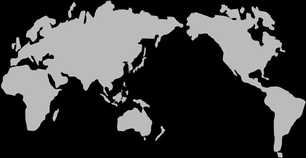


17 International Cooperation Global network/connections: partners in over 20 countries International Organizations Government, Institutions & Universities Companies
 International Program Office of Integrated")
 International Society for Digital Earth (ISDE) International Journal of Digital")
18 International organization hosted by RADI International Center on Space Technology for Natural and Cultural Heritage under the auspice of UNESCO (HIST) International Program Office of Integrated Research on Disaster Risk (IRDR IPO) CAS-TWAS Center of Excellence on Space Technology for Disaster Mitigation (SDIM) International Society for Digital Earth (ISDE) International Journal of Digital Earth (IJDE)
 founded in May, 2006, China The mission of the society is to provide a")


19 Digital Earth Society and Journal The International Society for Digital Earth (ISDE) founded in May, 2006, China The mission of the society is to provide a framework for understanding evolving societies and newly emergent technologies and to revise the Digital Earth Vision in light of current developments. ISDE Website: Inauguration IF First IF SCI-E Indexed IF IF IF Months IF 3.291
.")


20 International Programme Office for Integrated Research on Disaster Risk Being hosted by RADI (approved in November, 2009). First International Office of a large science program ever established in Asia. IRDR CHINA established in 2010, one of the national committees of IRDR Addressing the challenge of natural and human-induced environmental hazards An integrated approach to research on disaster risk through: an international, multidisciplinary (natural, health, engineering and social sciences, including socioeconomic analysis) collaborative research programme.


21 CAS-TWAS Centre of Excellence on Space Technology for Disaster Mitigation (SDIM) SDIM is committed to the studies of some key technologies of disaster reduction by using remote sensing, and focus on cooperation and capacity building for the developing countries. TWAS, Trieste, Italy CAS, Beijing, China Joint Research Program Education Training Workshop Conference and Seminar


22 International Collaborative Activities RADI-VITO MoU signed on June 23, at the witness of Chinese President Xi Jinping and the King Philippe of Belgium at the Great Hall of the People, to collaborate closely and structurally to jointly implement the concept report of the CropWatch science satellite constellation mission, which aims to monitor the vegetation, agriculture and water at a global scale. RADI-JRC collaborative research arrangement on June 29, at the witness of Chinese Premier LI Keqiang, Presidents of the European Council and the European Commission. The agreement was listed in the 17 th China-EU Summit joint statement as one of the major outcomes. Six major fields of cooperation: human settlements analysis, digital earth science platform, land and soil degradation, air quality, land cover mapping, and agricultural monitoring.


23 RADI-NASA Join hands in Glacier Change and Associated Hazards using Earth Observations Three Workshops: CAS-NASA Workshops in Nepal, USA and China. Two Main Themes: Glacier change and associated Hazards Pool the advantages of the two sides in EO and glacier and snow cover studies; Develop decision support tools for the sustainable development of the region; Promote the establishment of a mechanism underlying the long-term Sino-US cooperation on global change over HMA. Group photo in Nepal NASA Administrator Charles F. Bolden and the USA delegation visit RADI

24 Belt and Road (BAR) Initiative In 2013, the initiative of jointly building the Silk Road Economic Belt and the 21st Century Maritime Silk Road (hereafter referred to as the Belt and Road) was initiated by Chinese President Xi, which have attracted close attention from all over the world. In 2015, China focused on making all around progress in the "Belt and Road" framework.


25 Common Challenges of Countries along BAR
 remote")


26 Digital Belt and Road (DBAR) remote sensing satellites Space Big Data Share Platform Space Information System and Science Mode

27 Vision of DBAR Initiative Let countries along BAR benefit from DBAR Earlier, deeper and broader understand the belt and road to address common challenges as climate change, water resource, eco-environmental and food supply, in an integrative way. Build up scientific community for exchanging and sharing earth observation development and solution along the BAR countries, including capacity building. Strength and enhance Earth observation data infrastructure. Jointly promote Data sharing.

28
High Level Training Course on. World Heritage under the framework of Digital Belt and Road. (02 September 17 September, 2017)
") High Level Training Course on World Heritage under the framework of Digital Belt and Road (02 September 17 September, 2017) I. BACKGROUND The Silk Road Economic Belt and the 21st-Century Maritime Silk
High Level Training Course on World Heritage under the framework of Digital Belt and Road (02 September 17 September, 2017) I. BACKGROUND The Silk Road Economic Belt and the 21st-Century Maritime Silk
National Remote Sensing Center of China. Space Technology for Sustainable Development in China Status, Achievements and Futures.
 National Remote Sensing Center of China Space Technology for Sustainable Development in China Status, Achievements and Futures Jing Li National Remote Sensing Center of China Ministry of Science and Technology,
Surveying,Mapping and Geoinformation Services System for the Major Natural Disasters Emergency Management in China
 Surveying,Mapping and Geoinformation Services System for the Major Natural Disasters Emergency Management in China 21 February 2013, Bangkok, Thailand Contents 2 1 2 3 4 Working Mechanism Geoinformation
Background. The agreement s initial duration was six years.
 Evaluation and Renewal of the International Centre on Space Technologies for Natural and Cultural Heritage (HIST) under the auspices of UNESCO, Beijing, China Background The International Centre on Space
The Progress of China-GEOSS
 The 7th GEOSS Asia-Pacific Symposium The Progress of China-GEOSS Dr. YUE Huanyin yuehuanyin@nrscc.gov.cn National Remote Sensing Center of China Ministry of Science and Technology, P. R. China May 26,
sentinel-2 COLOUR VISION FOR COPERNICUS
 sentinel-2 COLOUR VISION FOR COPERNICUS SATELLITES TO SERVE By providing a set of key information services for a wide range of practical applications, Europe s Copernicus programme is providing a step
Capacity Building Activities at CRECTEALC. Ing. Jerjes Molina Blancas Professor and Developer.
 Capacity Building Activities at CRECTEALC Ing. Jerjes Molina Blancas Professor and Developer. Centro Regional de Enseñanza de Ciencia y Tecnología del Espacio para América Latina y el Caribe (CRECTEALC)
Japanese Programs on Space and Water Applications
 Japanese Programs on Space and Water Applications Tamotsu IGARASHI Remote Sensing Technology Center of Japan June 2006 COPUOS 2006 Vienna International Centre Water-related hazards/disasters may occur
Introduction of PASCO Corporation
 Technical Seminar Reference Frame in Practice, Introduction of PASCO Corporation MASAKI MIYASAKA Sponsors: Page 1 Company Profile Establishment: October 27, 1953 Head office: Meguro-ku, Tokyo (57 offices
Contribution to global Earth observation from satellites
 Contribution to global Earth observation from satellites - JAXA s Earth Observation strategy - April 16, 2008 Makoto Kajii Japan Aerospace Exploration Agency Earth Observation Summits and GEOSS 1 st EO
CONFERENCE STATEMENT
 CONFERENCE STATEMENT We, the elected representatives from Canada, Denmark/Greenland, Finland, Iceland, Norway, Russia, Sweden and the United States of America; In collaboration with the indigenous peoples
Report of the Regional Committee of UN-GGIM for Asia and the Pacific (UN-GGIM-AP)
") Report of the Regional Committee of UN-GGIM for Asia and the Pacific (UN-GGIM-AP) At the Eighth Session of UN-GGIM UN Headquarters, New York, 1 3 August 2018 About UN-GGIM-AP One of the five regional committees
Report of the Regional Committee of UN-GGIM for Asia and the Pacific (UN-GGIM-AP) At the Eighth Session of UN-GGIM UN Headquarters, New York, 1 3 August 2018 About UN-GGIM-AP One of the five regional committees
Geospatial Information and Services for Disasters (GIS4D)
") Geospatial Information and Services for Disasters (GIS4D) 31 July 2017 Tae Hyung KIM ICT and Disaster Risk Reduction Division (IDD) UNESCAP 1 About ESCAP Who is ESCAP? United Nations Economic and Social
Geospatial Information and Services for Disasters (GIS4D) 31 July 2017 Tae Hyung KIM ICT and Disaster Risk Reduction Division (IDD) UNESCAP 1 About ESCAP Who is ESCAP? United Nations Economic and Social
GIS and Remote Sensing
 Spring School Land use and the vulnerability of socio-ecosystems to climate change: remote sensing and modelling techniques GIS and Remote Sensing Katerina Tzavella Project Researcher PhD candidate Technology
FINDINGS OF THE ARCTIC METEOROLOGY SUMMIT
 FINDINGS OF THE ARCTIC METEOROLOGY SUMMIT 2018 WWW.FMI.FI CHAIR S SUMMARY: 1 2 3 We need to be curious to explore the known unknowns. Meteorology is an elemental part of international collaboration in
Emergency Management Service (EMS) mapping
 mapping") GMES Emergency Management Service (EMS) mapping Frédéric BASTIDE GMES unit, European Commission UN-SPIDER Expert Meeting: "Crowdsource Mapping for Disaster Risk Management and Emergency Response" 3-5 December,
GMES Emergency Management Service (EMS) mapping Frédéric BASTIDE GMES unit, European Commission UN-SPIDER Expert Meeting: "Crowdsource Mapping for Disaster Risk Management and Emergency Response" 3-5 December,
Copernicus Today and Tomorrow GEO Week Group on Earth Observation Geneva, 16 January 2014 The Copernicus Space Infrastructure
 Copernicus Today and Tomorrow GEO Week Group on Earth Observation Geneva, 16 January 2014 The Copernicus Space Infrastructure Thomas Beer, Policy Coordinator, Copernicus Space Office, ESA-ESRIN, Frascati
Remote Sensing and EO activities at the University of Turku
 Remote Sensing and EO activities at the University of Turku Niina Käyhkö Associate Professor Department of Geography and Geology GEO meeting/syke May 23rd, 2018 Geospatial competence at the University
The Integrated Ge spatial Information Framework to the strengthening of NSDI, Mongolia
 Young Geospatial Professionals Summit 21 NOV 2018 The Integrated Ge spatial Information Framework to the strengthening of NSDI, Mongolia BAYARMAA ENKHTUR Geospatial information and technology department
Geospatial Big Data. Greg Scott Inter-Regional Advisor Global Geospatial Information Management United Nations Statistics Division. ggim.un.
 Geospatial Big Data Greg Scott Inter-Regional Advisor Global Geospatial Information Management United Nations Statistics Division Positioning geospatial information to address global challenges ggim.un.org
Geo-information and Disaster Risk Reduction in the Hindu Kush-Himalayan region
 Geo-information and Disaster Risk Reduction in the Hindu Kush-Himalayan region Basanta Shrestha, Division Head MENRIS, International Centre for Integrated Mountain Development Kathmandu, Nepal The International
Part : General Situation of Surveying and Mapping. The Development of Surveying and Mapping in China. The contents
 The Development of Surveying and Mapping in China Dr. Ping Xiao China.P.R The contents Part : General Situation of Surveying and Mapping 1. The legal systems of surveying and mapping 2. The technologies
sentinel-3 A BIGGER PICTURE FOR COPERNICUS
 sentinel-3 A BIGGER PICTURE FOR COPERNICUS SATELLITES TO SERVE By providing a set of key information services for a wide range of practical applications, Europe s Copernicus programme has been put in place
Progress on GCOS-China CMA IOS Development Plan ( ) PEI, Chong Department of Integrated Observation of CMA 09/25/2017 Hangzhou, China
 PEI, Chong Department of Integrated Observation of CMA 09/25/2017 Hangzhou, China") Progress on GCOS-China CMA IOS Development Plan (2016-2020) PEI, Chong Department of Integrated Observation of CMA 09/25/2017 Hangzhou, China 1. Progress on GCOS-China 1 Organized GCOS-China GCOS-China
Progress on GCOS-China CMA IOS Development Plan (2016-2020) PEI, Chong Department of Integrated Observation of CMA 09/25/2017 Hangzhou, China 1. Progress on GCOS-China 1 Organized GCOS-China GCOS-China
Graduate Education in Institute of Chemistry, Chinese Academy of Sciences
 At 2014 IUPAC World Polymer Congress (MACRO 2014) July 6-11, Chiang Mai, Thailand Graduate Education in Institute of Chemistry, Chinese Academy of Sciences Jiasong He Institute of Chemistry, Chinese Academy
WMO Public Weather Services: Enhanced Communication Skills for Improved Service Delivery. by S.W. Muchemi (WMO)
") WMO Public Weather Services: Enhanced Communication Skills for Improved Service Delivery by S.W. Muchemi (WMO) Functions of the Public Weather Services (PWS) programme of WMO To strengthen the capabilities
WMO Public Weather Services: Enhanced Communication Skills for Improved Service Delivery by S.W. Muchemi (WMO) Functions of the Public Weather Services (PWS) programme of WMO To strengthen the capabilities
Spanish national plan for land observation: new collaborative production system in Europe
 ADVANCE UNEDITED VERSION UNITED NATIONS E/CONF.103/5/Add.1 Economic and Social Affairs 9 July 2013 Tenth United Nations Regional Cartographic Conference for the Americas New York, 19-23, August 2013 Item
What are the social, technical, environmental and economic benefits and opportunities of accessing and sharing geodetic data?
 What are the social, technical, environmental and economic benefits and opportunities of accessing and sharing geodetic data? Graeme Blick Group Manager Positioning and Resilience Land Information New
Earth Observations as a Tool To Achieve Sustainable Development Goals
 The image part with relationship ID rid3 was not found in the file. 16/10/2017 Earth Observations as a Tool To Achieve Sustainable Development Goals LI Jing, China GEO On behalf of the Group on Earth Observations
ZRCSAZU. Remote sensing and Earth observation data at ZRC SAZU. dr. Tatjana Veljanovski Atrij ZRC Ljubljana
 ZRCSAZU Remote sensing and Earth observation data at ZRC SAZU dr. Tatjana Veljanovski 2016-06-08 Atrij ZRC Ljubljana Remote Sensing Department Remote Sensing Department 20 years of experience application,
UNITED NATIONS E/CONF.96/CRP. 5
 UNITED NATIONS E/CONF.96/CRP. 5 ECONOMIC AND SOCIAL COUNCIL Eighth United Nations Regional Cartographic Conference for the Americas New York, 27 June -1 July 2005 Item 5 of the provisional agenda* COUNTRY
CLIMATE CHANGE ADAPTATION BY MEANS OF PUBLIC PRIVATE PARTNERSHIP TO ESTABLISH EARLY WARNING SYSTEM
 CLIMATE CHANGE ADAPTATION BY MEANS OF PUBLIC PRIVATE PARTNERSHIP TO ESTABLISH EARLY WARNING SYSTEM By: Dr Mamadou Lamine BAH, National Director Direction Nationale de la Meteorologie (DNM), Guinea President,
Copernicus Overview and Emergency Management Service
 Copernicus Overview and Emergency Management Service Frédéric BASTIDE European Commission Open informal session of the United Nations Inter-Agency Meeting on Outer Space Activities 12 March 2013, Geneva
The Spatial Information Corridor Contributes to UNISPACE+50. JIANG HUI Director of Internation Cooperation Department
 The Spatial Information Corridor Contributes to UNISPACE+50 JIANG HUI Director of Internation Cooperation Department 01 02 03 What is Belt & Road Spatial Information Corridor? China put forward the "Belt
Barnabas Chipindu, Department of Physics, University of Zimbabwe
 DEFICIENCIES IN THE OPERATIONAL APPLICATIONS OF LONG - RANGE WEATHER PREDICTIONS FOR AGRICULTURE - RECOMMENDATIONS FOR IMPROVING THE TECHNOLOGY FOR THE BENEFIT OF AGRICULTURE AT THE NATIONAL AND REGIONAL
GEOMATICS. Shaping our world. A company of
 GEOMATICS Shaping our world A company of OUR EXPERTISE Geomatics Geomatics plays a mayor role in hydropower, land and water resources, urban development, transport & mobility, renewable energy, and infrastructure
Summary of Global Mapping Forum 2003 in Okinawa and its Outcomes
 Summary of Global Mapping Forum 2003 in Okinawa and its Outcomes 1 Summary of Global Mapping Forum 2003 in Okinawa and its Outcomes Hidetoshi NAKAJIMA Abstract Global Mapping Forum 2003 in Okinawa was
GENERAL RECOMMENDATIONS. Session 7. Breakout discussion. discuss on regional and interregional. proposals 1. COLLABORATION BETWEEN PROGRAMMES
 Session 7 24 July 2016, 9.00-11.00 Breakout discussion on regional and interregional joint project proposals Mr Shahbaz Khan summarized the two days of presentations and exchanges and requested the participants
DLR s TerraSAR-X contributes to international fleet of radar satellites to map the Arctic and Antarctica
 DLR s TerraSAR-X contributes to international fleet of radar satellites to map the Arctic and Antarctica The polar regions play an important role in the Earth system. The snow and ice covered ocean and
SDG s and the role of Earth Observation
 SDG s and the role of Earth Observation Christian Heipke IPI - Institute for Photogrammetry and GeoInformation Leibniz Universität Hannover Germany Secretary General, ISPRS 1. No Poverty 2. Zero Hunger
UN-GGIM: Strengthening Geospatial Capability
 Fifth Plenary Meeting of UN-GGIM: Europe Brussels, 6-7 June 2018 UN-GGIM: Strengthening Geospatial Capability Walking the talk to leave no one behind Greg Scott, UN-GGIM Secretariat Environmental Statistics
Space Applications for Disaster Risk Reduction and Sustainable Development
 Space Applications for Disaster Risk Reduction and Sustainable Development Space Applications Section (SAS) ICT and Disaster Risk Reduction Division (IDD) UNESCAP Contents I. RESAP Activities 2016-2017
The Safeland Project General Overview and Monitoring Technology Development
 Ber. Geol. B. A., 82, ISSN 1017 8880 Landslide Monitoring Technologies & Early Warning Systems The Safeland Project General Overview and Monitoring Technology Development The SafeLand Consortium a), N.
C o p e r n i c u s a n d W I G O S
 C o p e r n i c u s a n d W I G O S Jean-Noël Thépaut & Mark Dowell 24 October 2017 GEO XIV, Washington DC, 23-28 October 2017 T h e C o p e r n i c u s P r o g r a m m e Copernicus is the European Union
Advancing Geoscientific Capability. Geological Survey of Finland
 Advancing Geoscientific Capability Geological Survey of Finland GTK in brief The Geological Survey of Finland (GTK) is one of the largest European centres of excellence in assessment, research and the
APPENDIX 2 OVERVIEW OF THE GLOBAL PRECIPITATION MEASUREMENT (GPM) AND THE TROPICAL RAINFALL MEASURING MISSION (TRMM) 2-1
 AND THE TROPICAL RAINFALL MEASURING MISSION (TRMM) 2-1") APPENDIX 2 OVERVIEW OF THE GLOBAL PRECIPITATION MEASUREMENT (GPM) AND THE TROPICAL RAINFALL MEASURING MISSION (TRMM) 2-1 1. Introduction Precipitation is one of most important environmental parameters.
APPENDIX 2 OVERVIEW OF THE GLOBAL PRECIPITATION MEASUREMENT (GPM) AND THE TROPICAL RAINFALL MEASURING MISSION (TRMM) 2-1 1. Introduction Precipitation is one of most important environmental parameters.
Surface Connects Author Index
 Surface Connects Author Index Shixin WANG, Yi ZHOU, Gewei LI, Weiqi ZHOU, Yalan LIU & Shirong CHEN NETWORK PLATFORM OF REMOTE SENSING FOR NATURAL DISASTER MONITORING & INFORMATION SERVING AND ITS APPLICATIONS
VISUALIZATION URBAN SPATIAL GROWTH OF DESERT CITIES FROM SATELLITE IMAGERY: A PRELIMINARY STUDY
 CO-439 VISUALIZATION URBAN SPATIAL GROWTH OF DESERT CITIES FROM SATELLITE IMAGERY: A PRELIMINARY STUDY YANG X. Florida State University, TALLAHASSEE, FLORIDA, UNITED STATES ABSTRACT Desert cities, particularly
Challenges and Potentials of Place Based Information Management in Nepal"
 Nineteenth United Nations Regional Cartographic Conference for Asia and the Pacific, Bangkok, Thailand, 29 October 1 November 2012 Challenges and Potentials of Place Based Information Management in Nepal"
Sentinel-1 Mission Status
 Sentinel-1 Mission Status Pierre Potin, Sentinel-1 Mission Manager, ESA Luca Martino, Technical Support Engineer, ESA... and the Sentinel-1 operations team PSTG SAR Coordination Working Group 14 December
Excel Geomatics: Offering Excellence with Unique Consultancy & Services
 Excel Geomatics: Offering Excellence with Unique Consultancy & Services Providing consultancy and value Added Services using Remote Sensing, Photogrammetry and LiDAR in areas such as Agriculture, Forestry,
FIG Asia Pacific Capacity Development Network
 FIG Asia Pacific Capacity Development Network Report to the 41th General Assembly FIG Congress 2018, Istanbul - Turkey Rob Sarib Chair FIG Asia Pacific Capacity Development Network (AP CDN) Story of the
Compact guides GISCO. Geographic information system of the Commission
 Compact guides GISCO Geographic information system of the Commission What is GISCO? GISCO, the Geographic Information System of the COmmission, is a permanent service of Eurostat that fulfils the requirements
WORLD DAY TO COMBAT DESERTIFICATION 2018 IN MONGOLIA
 WORLD DAY TO COMBAT DESERTIFICATION 2018 IN MONGOLIA This year the WDCD slogan was Land has true value. Invest in it to address the importance of sustainable land use, land degradation prevention and its
Geospatial framework for monitoring SDGs/Sendai targets By Shimonti Paul Sr. Assistant Editor Geospatial Media & Communications
 Geospatial framework for monitoring SDGs/Sendai targets By Shimonti Paul Sr. Assistant Editor Geospatial Media & Communications Outline 1. Introduction to Geospatial Media and Communications 2. Geospatial
Status and Data Applications of China Highresolution Earth Observation System. Earth Observation System and Data Center, CNSA Sep, 2016
 Status and Data Applications of China Highresolution Earth Observation System Earth Observation System and Data Center, CNSA Sep, 2016 Outlines Introduction Development of the Space-based System CHEOS
Space Application in Support of Land Management for SDG Implementation
 Space Application in Support of Land Management for SDG Implementation Regional Expert Workshop on Land Accounting for SDG Monitoring and Reporting 26 September 2017 Space Application Section Information
M. Mikoš. Faculty of Civil and Geodetic Engineering, University of Ljubljana, Ljubljana, Slovenia
 Proceedings of the Mediterranean Meeting on Monitoring, modelling and early warning of extreme events triggered by heavy rainfalls. PON 01_01503 - MED-FRIEND project University of Calabria, Cosenza (Italy),
UN COPUOS 52 nd session of the Scientific and Technical Subcommittee. COPERNICUS - an European Achievement. S. Jutz Head, ESA Copernicus Space Office
 UN COPUOS 52 nd session of the Scientific and Technical Subcommittee COPERNICUS - an European Achievement S. Jutz Head, ESA Copernicus Space Office 11 Feb 2015, Vienna 1 2 What is Copernicus? European
Building Institutional Capacity for Multi-Hazard Early Warning in Asia and the Pacific Subtitle
 Building Institutional Capacity for Multi-Hazard Early Warning in Asia and the Pacific Subtitle Title Keran Wang Chief, Space Applications Section ICT and Disaster Risk Reduction Division 22 May 2018 Pillar
ECONOMIC AND SOCIAL COUNCIL
 UNITED NATIONS E/CONF.102/3 ECONOMIC AND SOCIAL COUNCIL Nineteenth United Nations Regional Cartographic Conference for Asia and the Pacific Bangkok, 29 October 1 November 2012 Item 4 of the provisional
Country Report Nepal Geospatial Data Sharing Initiatives of Survey Department Supporting Disaster Management
 Third JPTM Step 2 for Sentinel Asia 6-8 July, 2010 Manila, The Philippines Country Report Nepal Geospatial Data Sharing Initiatives of Survey Department Supporting Disaster Management Durgendra M Kayastha
AND THE COOPERATION WITH SENTINEL ASIA FOR DISASTER MANAGEMENT
 Ministry of Natural resources and Environment National Remote Sensing DEpartment NATIONAL REMOTE SENSING DEPARTMENT (NRSD) AND THE COOPERATION WITH SENTINEL ASIA FOR DISASTER MANAGEMENT By: Dr. Chu Hai
Copernicus Overview. Major Emergency Management Conference Athlone 2017
 Copernicus Overview Major Emergency Management Conference Athlone 2017 Copernicus is a European programme implemented by the European Commission. The services address six thematic areas: land, marine,
Supporting GPSC Cities with Satellite Earth Observation for Sustainable Urban Development
 Supporting GPSC Cities with Satellite Earth Observation for Sustainable Urban Development Global Platform for Sustainable Cities African Regional Workshop 14 May 2018 AfDB Headquarters Abidjan, Côte d'ivoire
Geospatial Information Management in the Americas: Lessons for the Post-2015 development agenda
 Geospatial Information Management in the Americas: Lessons for the Post-2015 development agenda Rolando Ocampo President, UN-GGIM: Americas October 2014 The integration of statistical and geographical
Spatially Enabled Society
 International Seminar on Land Administration Trends and Issues in Asia and the Pacific Region Spatially Enabled Society Abbas Rajabifard Vice Chair PCGIAP-WG3 Vice-President (President Elect), GSDI Association
Interregional Cooperation in the Apennines
 INTERNATIONAL WORKSHOP THE ALPS AND THE ARDENNES: SHARING EXPERIENCES AMONG TRANSBOUNDARY MOUNTAIN AREAS Interregional Cooperation in the Apennines Massimo Sargolini, professor at the University of Camerino,
COUNCIL OF THE EUROPEAN UNION. Brussels, 2 May /14 CULT 68
 COUNCIL OF THE EUROPEAN UNION Brussels, 2 May 2014 9129/14 CULT 68 NOTE from: General Secretariat of the Council to: Permanent Representatives Committee (Part 1) / Council No. prev. doc.: 8892/14 CULT
EO4SEE - THE PATHFINDER OF OPERATIONAL SATELLITE MONITORING FOR THE REGION OF THE BLACK SEA AND CENTRAL EUROPE
 EO4SEE: Pathfinder assessment for regional high volume data access, processing and information service delivery platforms - South East Region EO4SEE - THE PATHFINDER OF OPERATIONAL SATELLITE MONITORING
RETA 6422: Mainstreaming Environment for Poverty Reduction Category 2 Subproject
 RETA 6422: Mainstreaming Environment for Poverty Reduction Category 2 Subproject A. Basic Data 1. Subproject Title: Poverty-Environment Mapping to Support Decision Making 2. Country Director: Adrian Ruthenberg
Catalysing Innovation in Weather Science - the role of observations and NWP in the World Weather Research Programme
 Catalysing Innovation in Weather Science - the role of observations and NWP in the World Weather Research Programme Estelle de Coning, Paolo Ruti, Julia Keller World Weather Research Division The World
THE ROLE OF GEOSPATIAL AT THE WORLD BANK
 THE ROLE OF GEOSPATIAL AT THE WORLD BANK INSPIRE Conference Barcelona, Spain September 26, 2016 Kathrine Kelm Senior Land Administration Specialist Global Land and Geospatial Unit The World Bank Group
Dr Ozlem Adiyaman Earth Sciences and Geo-hazards Risk Reduction Section Division of Ecological and Earth Sciences ( ) NATURAL SCIENCES
 NATURAL SCIENCES") Earth Sciences and Geo-hazards Risk Reduction Section Earth observation with COPERNICUS to : protect, monitor, document, present and share our common heritage, our cultural and natural UNESCO World Heritage
Earth Sciences and Geo-hazards Risk Reduction Section Earth observation with COPERNICUS to : protect, monitor, document, present and share our common heritage, our cultural and natural UNESCO World Heritage
Intelligent City Management
 Intelligent City Management Based on Land Cover Feature Changes Detected by Satellite Imagery Twenty First Century Aerospace Technology (21AT) www.21at.com.cn Geospatial World Forum 2016 Outline 01 Introduction
Capacity Building Programme
 Capacity Building Programme 14-17 August 2012 Space Technology for improving Hazard Mapping in Sri Lanka An event organised as a follow up of the UN-SPIDER Technical Advisory Mission to Sri Lanka - 17-21
GEOGRAPHY (GE) Courses of Instruction
 Courses of Instruction") GEOGRAPHY (GE) GE 102. (3) World Regional Geography. The geographic method of inquiry is used to examine, describe, explain, and analyze the human and physical environments of the major regions of the
GEOGRAPHY (GE) GE 102. (3) World Regional Geography. The geographic method of inquiry is used to examine, describe, explain, and analyze the human and physical environments of the major regions of the
Space Technology for Sustainable Development
 National Remote Sensing Center of China National Remote Sensing Center of China Space Technology for Sustainable Development Active Custom Active Custom Satellite development Satellite serialization, bus
Geohazard Supersites and Natural Laboratories
 Geohazard Supersites and Natural Laboratories FRINGE 2011, Frascati, Italy, September 19, 2011 Wolfgang Lengert, ESA Falk Amelung, University of Miami, GEO task lead Craig Dobson, NASA, CEOS task lead
Urban areas & climate change
 Urban areas & climate change Paolo Gamba University of Pavia University of Pavia The UNIPV TLC & RS Lab is a dynamic research group developing in the past years many techniques devoted to the analysis
Economic and Social Council
 United Nations Economic and Social Council Distr.: General 2 July 2012 E/C.20/2012/10/Add.1 Original: English Committee of Experts on Global Geospatial Information Management Second session New York, 13-15
Remote sensing of haze aerosol over eastern China
 ISALSaRS'17, USTC, 21-June-2017 China University of Mining and Technology Remote sensing of haze aerosol over eastern China Qin Kai( 秦凯 ), CUMT ( 中国矿业大学 ) Wu Lixin, CSU( 中南大学 ) Wong Mansing, Hong Kong
RESAP Progress Report
 RESAP Progress Report December 2016 to October 2017 Presentation to the Twenty-first session of the Intergovernmental Consultative Committee on the Regional Space Applications Programme for Sustainable
GEO-VIII November Geohazard Supersites and Natural Laboratories Progress Report. Document 9
 GEO-VIII 16-17 November 2011 Geohazard Supersites and Natural Laboratories Progress Report Document 9 This document is submitted to GEO-VIII for information. Geohazard Supersites and Natural Laboratories
Economic and Social Council
 United Nations Economic and Social Council Distr.: General 18 July 2016 Original: English Committee of Experts on Global Geospatial Information Management Sixth session New York, 3-5 August 2016 Item 2
16540/14 EE/cm 1 DG E 1A
 Council of the European Union Brussels, 5 December 2014 (OR. en) 16540/14 ENV 965 CULT 139 NOTE From: To: Subject: General Secretariat of the Council Delegations Charter of Rome on Natural and Cultural
SDI Development in Georgia. Mari Khardziani Head of International Relations Unit National Agency of Public Registry
 SDI Development in Georgia Mari Khardziani Head of International Relations Unit National Agency of Public Registry Kehl, Germany September 5, 2017 2 National Agency of Public Registry Legal Entity of Public
Group on Earth Observations (GEO) Cold Regions Work Plan Item WA-01-C3
 Cold Regions Work Plan Item WA-01-C3") EC Panel of Experts on Polar Observations, Research and Services Group on Earth Observations (GEO) Cold Regions Work Plan Item WA-01-C3 Barbara J. Ryan Secretariat Director Lanzhou, China 13 March 2013
EC Panel of Experts on Polar Observations, Research and Services Group on Earth Observations (GEO) Cold Regions Work Plan Item WA-01-C3 Barbara J. Ryan Secretariat Director Lanzhou, China 13 March 2013
Louis-François Guerre, Planet Action Coordinator Copenhagen, December Spot Image 2007
 Louis-François Guerre, Planet Action Coordinator Copenhagen, December 2009 1 Spot Image 2007 Spot Image, Earth Observation and geo-information services Satellite operator, imagery distributor SPOT4 SPOT5
Historical background
 Space Technology for Disaster Management in Sri Lanka: Country profile, national perspectives & vision. Professor Ranjith Premalal De Silva Vice Chancellor Uva Wellassa University of Sri Lanka October
Egypt-NOAA Cooperation: Advancing our Environmental Science, Technology, and Education
 Egypt-NOAA Cooperation: Advancing our Environmental Science, Technology, and Education T. G. Onsager NOAA Space Weather Prediction Center and NWS International Activities Office (one-year detail) Terry.Onsager@noaa.gov
Application of remote sensing for agricultural disasters
 Application of remote sensing for agricultural disasters Bingfang Wu, Sheng Chang Institute of Remote Sensing and Digital Earth (RADI) Chinese Academy of Sciences (CAS) wubf@radi.ac.cn, changsheng@radi.ac.cn
Introduction of the Asia-Oceania Global Earth Observation System of Systems (AOGEOSS) GEO Initiative(GI-22 )
 GEO Initiative(GI-22 )") Introduction of the Asia-Oceania Global Earth Observation System of Systems (AOGEOSS) GEO Initiative(GI-22 ) Prof. Xiang ZHOU Institute of Remote Sensing and Digital Earth, CAS 11 May 2017 Kunming, China
Introduction of the Asia-Oceania Global Earth Observation System of Systems (AOGEOSS) GEO Initiative(GI-22 ) Prof. Xiang ZHOU Institute of Remote Sensing and Digital Earth, CAS 11 May 2017 Kunming, China
History & Scope of Remote Sensing FOUNDATIONS
 History & Scope of Remote Sensing FOUNDATIONS Lecture Overview Introduction Overview of visual information Power of imagery Definition What is remote sensing? Definition standard for class History of Remote
The Infrastructure for Spatial Information in the European Community vs. regional SDI: the shortest way for reaching economic and social development
 The Infrastructure for Spatial Information in the European Community vs. regional SDI: the shortest way for reaching economic and social development Mauro Salvemini EUROGI PRESIDENT Professor at Sapienza
USING GIS CARTOGRAPHIC MODELING TO ANALYSIS SPATIAL DISTRIBUTION OF LANDSLIDE SENSITIVE AREAS IN YANGMINGSHAN NATIONAL PARK, TAIWAN
 CO-145 USING GIS CARTOGRAPHIC MODELING TO ANALYSIS SPATIAL DISTRIBUTION OF LANDSLIDE SENSITIVE AREAS IN YANGMINGSHAN NATIONAL PARK, TAIWAN DING Y.C. Chinese Culture University., TAIPEI, TAIWAN, PROVINCE
F I G PA RT LX capacity in natural disaster area and disaster survey case in Jeju area
 F I G PA RT 7 2017. 12. 6. LX capacity in natural disaster area and disaster survey case in Jeju area Reporting order 1 2 3 General Information of LX Competence of LX on Natural disaster area Examples
Application Status and Prospect of Microwave Remote Sensing
 2017 International Conference on Computing, Communications and Automation(I3CA 2017) Application Status and Prospect of Microwave Remote Sensing Cheng Lele, Yan Xinsui, Zhou Mengqiu, Zhou Yongqin, Wang
Impact Policies Enabling Value Enhancement of Geospatial Information in Canadian Economy and Society
 1 Impact Policies Enabling Value Enhancement of Geospatial Information in Canadian Economy and Society May 26, 2015 Prashant Shukle, Director General Canada Centre for Mapping and Earth Observation Increased
CGMS Baseline. Sustained contributions to the Global Observing System. Endorsed by CGMS-46 in Bengaluru, June 2018
 CGMS Baseline Sustained contributions to the Global Observing System Best Practices for Achieving User Readiness for New Meteorological Satellites Endorsed by CGMS-46 in Bengaluru, June 2018 CGMS/DOC/18/1028862,