Social Networks and Travel Behaviour
|
|
|
- Shauna Underwood
- 5 years ago
- Views:
Transcription


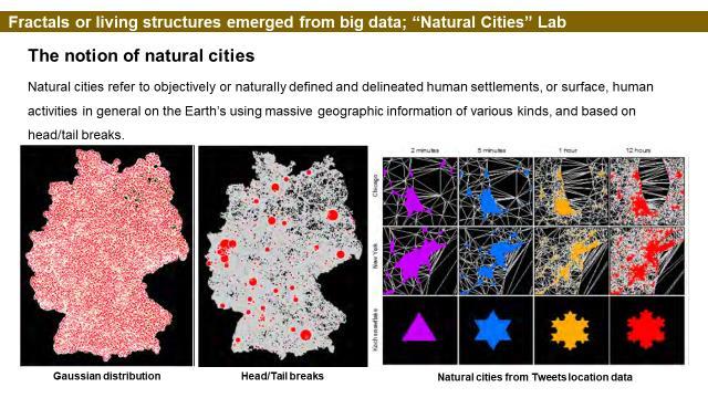
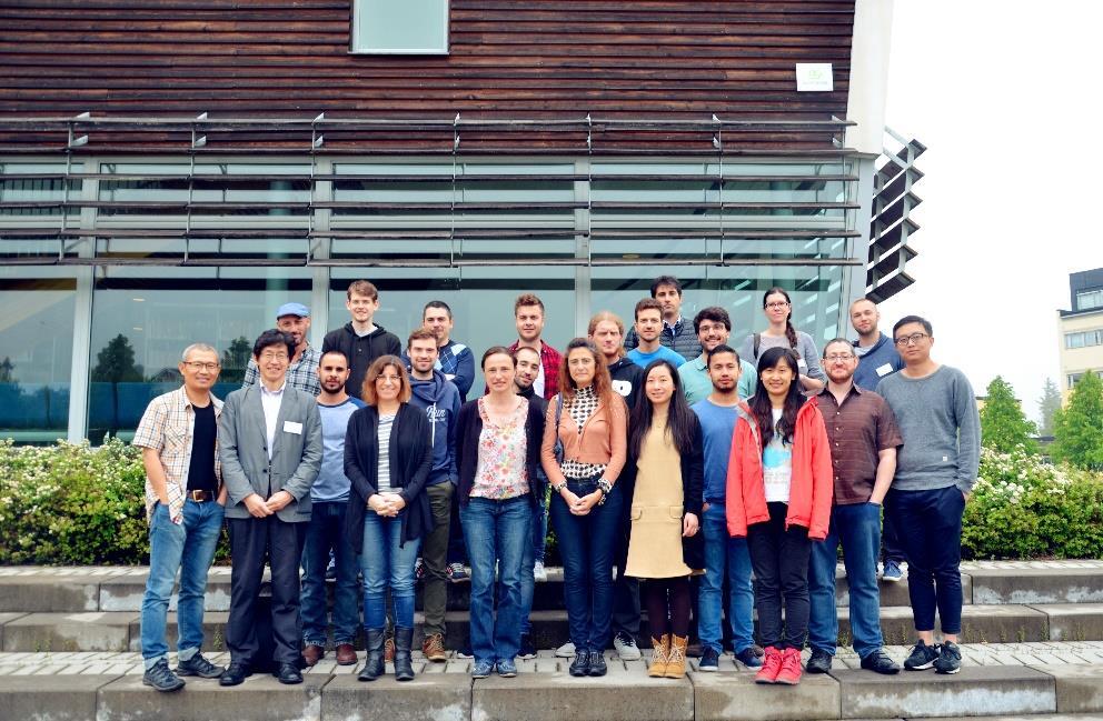
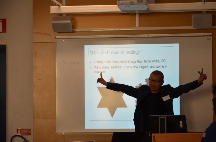
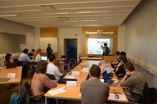
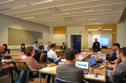
1 COST Action TU1305 Social Networks and Travel Behaviour Training school in Gavle, Sweden June 13 th - 17 th 2016: Topological and Scaling Ways of Thinking for Social Networks and Travel Behavior Summary by Prof. Bin Jiang Current geospatial analysis is highly constrained, consciously or subconsciously, by Euclidean geometry and Gaussian statistics in the sense of geometric details such as locations, directions, and sizes, and these geometric details are with a well-defined mean and small variance. These two ways of thinking Euclidean geometric and Gaussian statistical suffer from some major disadvantages that prevent us from developing new insights into the underlying complexity of geographic phenomena, e.g., social networks and travel behavior. On the other hand, topology without geometric details, fractal geometry, which is under the third definition of fractal: a set or pattern is fractal if the scaling of far more small things than larges recurs multiple times or with the ht-index being at least three (Jiang and Yin 2014), and power law statistics represent new perspectives for geospatial analysis, particularly in the era of big data, for better understanding social networks and travel behavior. Given the circumstances, we organized the summer school on alternative geospatial analysis methods surrounding topological and scaling ways of thinking. These methods include for example head/tail breaks (Jiang 2013), ht-index (Jiang and Yin 2014), topological analysis (Jiang and Claramunt 2004), complex networks, and agent-based simulations in various applications of pedestrian modeling and human evacuation. The summer school was further motivated by the emerging big data harvested from the Internet and social media such as OpenStreetMap, Flickr, Twitter, and Brightkite, which provide a new instrument for transport research and human mobility (Jiang and Miao 2015). Big data differs fundamentally from small data in terms of basic data characteristics such as accurately measured or roughly estimated, individual-based or aggregated, and massive or small amounts. Big data also differs fundamentally from small data in terms of the data analytics that surround these two ways of thinking, geometrically and statistically. The summer school was combined with lectures, hands-on exercises, discussions, and projects. We provided related data obtained from OpenStreetMap, Twitter, Brightkite, and Gowalla for the hands-on parts. We offered a brainstorm session that had led to some joint publications among the participants. Over 20 young researchers (PhD 1
2 students and postdoc researchers) and three senior instructors have one-week intensive discussions and exchanges during the five-day summer school. For more details about the summer school, one can refer to this site: Organizer: Bin Jiang, PhD and Professor Faculty of Engineering and Sustainable Development, Division of GIScience University of Gävle, SE Gävle, Sweden. Trainers: Prof. Bin Jiang, University of Gävle, Sweden Dr. Marija Mitrovic Dankulov, University of Belgrade, Serbia Prof. Toshi Osaragi, Tokyo Institute of Technology, Japan Prof. Itzhak Omer, Tel Aviv University, Israel Trainees: Name Country Status Institute Research field Joris Becker Belgium PhD student University of Antwerpen Geography Gaëtan Montero Belgium PhD candidate David Kocich Czech Republic PhD student Xiaoyan XIE France post doc Université Catholique de Louvain Institute of Geoinformatics, VSB - Technical University of Ostrava LVMT (Laboratoire Ville Mobilité Transport) École Nationale des Ponts et Chaussées (ENPC) Jakub Krukar Germany post doc University of Munster Kornilia Maria Kotoula Greece PhD candidate Centre for Research and Technology/Hellenic Institute of Transport (CERTH/HIT) Geography Geoinformatics (physical geography) PT (modelling, simulation, evaluation); Trafic flow theory; Urban mobility Geo-informatic (Psychology & architecture) Transport research 2
3 Name Country Status Institute Research field Dalit Shach Pinsly Israel Dr. (MC member) Technion Yoav Lerman Israel Dr. Ben Gurion University Yuval Rubinstein Israel M.Sc. student Technion Nir Kaplan Israel PhD student Tel Aviv University Karim Keramat Jahromi Architecture + Urban Planning Geography (mba, computer sci) Architecture + Urban Planning Geography and urban planning Italy PhD student Milano University Computer science Stefano Pensa Italy post doc (MC Sub) Daniele Oxoli Italy PhD student Odette Lewis Malta Dr (2013) MC member Luis Fernando Santa Portugal PhD student Francisco Pedro Luque Spain Researcher Maria del Mar Alonso Spain Dr. (2007) (MC S member) Anastasios Koutoulas Sweden PhD candidate Politecnico di Torino Dept. of Civil and Environmental Engineering, Politecnico di Milano, Como Campus University of Malta Universidade Nova de Lisboa CeDInt-UPM (Center of energy efficiency), Madrid Autonomous University of Madrid KTH Royal Institute of תTechnology Stokholm, Sweden Ding Ma Sweden PhD student University of Gävle Leonard Nilsson Sweden PhD student Chalmers University of Technology Architecture / geovisualisation / accessibility of public spaces Geomatics // analysis and manipulation of geospatial data Transport engineering, decision making policy Geomatics Telecomunications Engineering (M.Sc) Virtual Reality Economics and Business Administration, Tourism Transportation engineering Geospatial Information Science Architecture, Software development, GIS 3


4 Training school summary Presentation in London Meeting by Arch. Yuval Rubinstein, Israel. 4
5 5
6 6
7 7
Spatial Heterogeneity, Scale, Data Character and Sustainable Transport in the Big Data Era
 Editorial Spatial Heterogeneity, Scale, Data Character and Sustainable Transport in the Big Data Era Bin Jiang Faculty of Engineering and Sustainable Development, Division of GIScience, University of Gävle,
Editorial: Bin Jiang
 Editorial: Spatial Heterogeneity, Scale, Data Character, and Sustainable Transport T inn the Big Data Era Bin Jiang Faculty of Engineering and Sustainable Development, Division of GIScience University
Line Simplification. Bin Jiang
 Line Simplification Bin Jiang Department of Technology and Built Environment, Division of GIScience University of Gävle, SE-801 76 Gävle, Sweden Email: bin.jiang@hig.se (Draft: July 2013, Revision: March,
Unit of Study: Physical Geography & Settlement Patterns; Culture & Civilizations; and The Spread of Ideas
 6 th Grade Social Studies 1 st Nine Weeks TEKS Unit of Study: Physical Geography & Settlement Patterns; Culture & Civilizations; and The Spread of Ideas 6.1) History. The student understands that historical
A Markov system analysis application on labour market dynamics: The case of Greece
 + A Markov system analysis application on labour market dynamics: The case of Greece Maria Symeonaki Glykeria Stamatopoulou This project has received funding from the European Union s Horizon 2020 research
Future of Geography an international perspective
 Future of Geography an international perspective Colin Arrowsmith School of Mathematical and Geospatial Sciences RMIT University Melbourne, Victoria, Australia Mathematical and Geospatial Sciences Slide
GIS based modeling of chemical fate, transport and impacts for policy support
 GENERAL INFORMATION Chemical risk communication and management increasingly requires mapping of exposure and vulnerability. Maps are often ideal tools both from the perspective of public decision makers,
Curriculum Vita. Timothy J. Niblett
 Curriculum Vita Timothy J. Niblett CONTACT DETAILS 3416 Bellevue Drive Modesto, CA 95350 tniblett@ucsb.edu (209) 480-0467 EDUCATION Ph.D M.A. M.A. B.A. 2016, University of California at Santa Barbara (Geography)
First International Conference on Smart Data and Smart Cities, 30 th UDMS September 7 9, 2016, University of Split, Croatia
 First International Conference on Smart Data and Smart Cities, 30 th UDMS September 7 9, 2016, University of Split, Croatia First International Conference on Smart Data and Smart Cities was held in Split,
Esri and GIS Education
 Esri and GIS Education Organizations Esri Users 1,200 National Government Agencies 11,500 States & Regional Agencies 30,800 Cities & Local Governments 32,000 Businesses 8,500 Utilities 12,600 NGOs 11,000
Key Points Sharing fosters participation and collaboration Metadata has a big role in sharing Sharing is not always easy
 Sharing Resources Geoff Mortson esri, Inc. SDI Solutions Team Key Points Sharing fosters participation and collaboration Metadata has a big role in sharing Sharing is not always easy Data Sharing is Good
Texas Essential Knowledge and Skills (TEKS) Science Grade: 6 - Adopted: 2010
 Science Grade: 6 - Adopted: 2010") Main Criteria: Texas Essential Knowledge and Skills (TEKS) Secondary Criteria: Subjects: Science, Social Studies Grade: 6 Correlation Options: Show Correlated Texas Essential Knowledge and Skills (TEKS)
Main Criteria: Texas Essential Knowledge and Skills (TEKS) Secondary Criteria: Subjects: Science, Social Studies Grade: 6 Correlation Options: Show Correlated Texas Essential Knowledge and Skills (TEKS)
Lecture 7: Cellular Automata Modelling: Principles of Cell Space Simulation
 SCHOOL OF GEOGRAPHY Lecture 7: Cellular Automata Modelling: Principles of Cell Space Simulation Outline Types of Urban Models Again The Cellular Automata Approach: Urban Growth and Complexity Theory The
Place Syntax Tool (PST)
") Place Syntax Tool (PST) Alexander Ståhle To cite this report: Alexander Ståhle (2012) Place Syntax Tool (PST), in Angela Hull, Cecília Silva and Luca Bertolini (Eds.) Accessibility Instruments for Planning
Place Syntax Tool (PST) Alexander Ståhle To cite this report: Alexander Ståhle (2012) Place Syntax Tool (PST), in Angela Hull, Cecília Silva and Luca Bertolini (Eds.) Accessibility Instruments for Planning
Geographic Information for Economic and Spatial Decisions
 !"#$!%& ''"(')* +"&'",, *+""-./0 Geographic Information for Economic and Spatial Decisions Objectives The master is aimed at creating skilled professionals in Geographic Information, qualified to work
I&CLC2000 in support to new policy initiatives (INSPIRE, GMES,..)
") I&CLC2000 in support to new policy initiatives (INSPIRE, GMES,..) Manfred Grasserbauer, Director Joint Research Centre Institute for Environment and Sustainability 1 IMAGE 2000 European mosaic of satellite
I&CLC2000 in support to new policy initiatives (INSPIRE, GMES,..) Manfred Grasserbauer, Director Joint Research Centre Institute for Environment and Sustainability 1 IMAGE 2000 European mosaic of satellite
ACCESSIBILITY TO SERVICES IN REGIONS AND CITIES: MEASURES AND POLICIES NOTE FOR THE WPTI WORKSHOP, 18 JUNE 2013
 ACCESSIBILITY TO SERVICES IN REGIONS AND CITIES: MEASURES AND POLICIES NOTE FOR THE WPTI WORKSHOP, 18 JUNE 2013 1. Significant differences in the access to basic and advanced services, such as transport,
International Summer School of Economic, Financial. and Management Studies
 International Summer School of Economic, Financial Date: 17. 6. 23. 6. 2018 and Management Studies Place: Faculty of Economics VŠB-TU Ostrava (VŠB-TUO, GPS: 49 83 67.07 N, 18 28 72.85 E) Registration:
University of Mining and Geology
 University of Mining and Geology University of Mining and Geology 1. Introduction 2. The study at UMG 3. The research at UMG 4. International Cooperation University of Mining and Geology 1. Introduction
geographic patterns and processes are captured and represented using computer technologies
 Proposed Certificate in Geographic Information Science Department of Geographical and Sustainability Sciences Submitted: November 9, 2016 Geographic information systems (GIS) capture the complex spatial
GIS Ostrava 2014 Final resume
 GIS Ostrava 2014 Final resume The 11 th Symposium GIS Ostrava 2014 was held in the New Hall of the Technical University of Ostrava for three days since Jan 27th to Jan 29th. Similarly, as in previous years,
REAL-TIME GIS OF GENDER
 2 nd Conference on Advanced Modeling and Analysis MOPT/IGOT/CEG REAL-TIME GIS OF GENDER A telegeomonitoring approach PT07 Mainstreaming Gender Equality and Promoting Work Life Balance (2nd Open Call -
Friendship and Mobility: User Movement In Location-Based Social Networks. Eunjoon Cho* Seth A. Myers* Jure Leskovec
 Friendship and Mobility: User Movement In Location-Based Social Networks Eunjoon Cho* Seth A. Myers* Jure Leskovec Outline Introduction Related Work Data Observations from Data Model of Human Mobility
ESSENTIAL CONCEPTS AND SKILL SETS OF THE IOWA CORE CURRICULUM
 ESSENTIAL CONCEPTS AND SKILL SETS OF THE IOWA CORE CURRICULUM SOCIAL STUDIES PROVIDED BY THE IOWA DEPARTMENT OF EDUCATION INTRODUCTION Social studies is the integrated study of the social sciences and
Joanne N. Halls, PhD Dept. of Geography & Geology David Kirk Information Technology Services
 Joanne N. Halls, PhD Dept. of Geography & Geology David Kirk Information Technology Services Geographic Information Systems manage and analyze data to solve spatial problems. Real World Abstraction Analysis
Lecture 7: Cellular Automata Modelling: Principles of Cell Space Simulation
 MRes in Advanced Spatial Analysis and Visualisation Lecture 7: Cellular Automata Modelling: Principles of Cell Space Simulation Outline Types of Urban Models Again The Cellular Automata Approach: Urban
ECONOMIC AND SOCIAL COUNCIL 13 July 2007
 UNITED NATIONS E/CONF.98/CRP.34 ECONOMIC AND SOCIAL COUNCIL 13 July 2007 Ninth United Nations Conference on the Standardization of Geographical Names New York, 21-30 August 2007 Item 17(b) of the provisional
Understanding China Census Data with GIS By Shuming Bao and Susan Haynie China Data Center, University of Michigan
 Understanding China Census Data with GIS By Shuming Bao and Susan Haynie China Data Center, University of Michigan The Census data for China provides comprehensive demographic and business information
Mapping Secondary Cities for Resiliency and Emergency Preparedness
 Mapping Secondary Cities for Resiliency and Emergency Preparedness Secondary Cities Geospatial Training Workshop Pilot Project: Cusco, Peru June 29 July 3 2015 WHO ARE WE? Office of the Geographer (GGI)
POLIMI ACTIVITIES urban data collection and preprocessing
 Project Meeting, 22 January 2018, Rome PRIN PROJECT: URBAN GEOmatics for Bulk Information Generation, Data Assessment and Technology Awareness POLIMI ACTIVITIES urban data collection and preprocessing
Chair: Enrico Rispoli. Commission 3 Spatial Information Management Presentation
 Chair: Enrico Rispoli Commission 3 Spatial Information Management Presentation 1 Agenda Commission 3 Meeting Helsinki, 31.05.2017 - Greetings of the chair and focus on working plan; - Organization of Commission
VGIscience Summer School Interpretation, Visualisation and Social Computing of Volunteered Geographic Information (VGI)
") VGIscience Summer School Interpretation, Visualisation and Social Computing of Volunteered Geographic Information (VGI) TU Dresden, 11.-15. September 2017 Welcome PhD students working on research topics
VGIscience Summer School Interpretation, Visualisation and Social Computing of Volunteered Geographic Information (VGI) TU Dresden, 11.-15. September 2017 Welcome PhD students working on research topics
2 nd EUROGI imagine Conference 2014 GI - Expertise Made in Europe 8 & 9 October 2014 in Berlin, Germany
 GEO-INFORMATION FOR JOB CREATION AND ECONOMIC GROWTH Conference block organised by the French Umbrella Association for Geospatial Information Moderator: Rapporteur: François Salgé AFIGéO Executive committee
Future Proofing the Provision of Geoinformation: Emerging Technologies
 Future Proofing the Provision of Geoinformation: Emerging Technologies An Exchange Forum with the Geospatial Industry William Cartwright Chair JBGIS Second High Level Forum on Global Geospatial Information
Cartography and Children Commission: Proposals for the next 4 years
 International Cartographic Association Cartography and Children Commission: Proposals for the next 4 years José Jesús Reyes Nuñez Eötvös Loránd University Dept. of Cartography and Geoinformatics Budapest,
WHO EpiData. A monthly summary of the epidemiological data on selected Vaccine preventable diseases in the WHO European Region
 A monthly summary of the epidemiological data on selected Vaccine preventable diseases in the WHO European Region Table 1: Reported cases for the period January December 2018 (data as of 01 February 2019)
Issues around verification, validation, calibration, and confirmation of agent-based models of complex spatial systems
 Issues around verification, validation, calibration, and confirmation of agent-based models of complex spatial systems David O Sullivan 1 Mark Gahegan 2 1 School of Geography, Geology, and Environmental
Interactive Visualization Tool (InViTo)
") Interactive Visualization Tool (InViTo) Stefano Pensa To cite this report: Stefano Pensa (2012) Interactive Visualization Tool (InViTo), in Angela Hull, Cecília Silva and Luca Bertolini (Eds.) Accessibility
Interactive Visualization Tool (InViTo) Stefano Pensa To cite this report: Stefano Pensa (2012) Interactive Visualization Tool (InViTo), in Angela Hull, Cecília Silva and Luca Bertolini (Eds.) Accessibility
XXIII CONGRESS OF ISPRS RESOLUTIONS
 XXIII CONGRESS OF ISPRS RESOLUTIONS General Resolutions Resolution 0: Thanks to the Czech Society commends: To congratulate The Czech Society, its president and the Congress Director Lena Halounová, the
Cognitive Engineering for Geographic Information Science
 Cognitive Engineering for Geographic Information Science Martin Raubal Department of Geography, UCSB raubal@geog.ucsb.edu 21 Jan 2009 ThinkSpatial, UCSB 1 GIScience Motivation systematic study of all aspects
Max Planck Institute for Chemistry, Multiphase Chemistry Department, Mainz, Germany 2. University of Novi Sad, Faculty of Sciences, Novi Sad, Serbia 4
 Chemistry in Environmental Sciences Related Higher Education (BSc and MSc) Programmes in Europe Gerhard Lammel 1,2, Ivana Ivancev-Tumbas 3, Eric Jover Comas 4 1 Max Planck Institute for Chemistry, Multiphase
City of Jerez Urban Core Densification proposal; An Agent Based Spatio-temporal model
 Modelling urban population allocation City of Jerez Urban Core Densification proposal; An Agent Based Spatio-temporal model Elke Sauter Julia Úbeda Who we are & why we are here Masters programme: Geographical
UN-GGIM: An Overview Stefan Schweinfest, Director (UNSD) Bangkok, 27 March 2015
 Bangkok, 27 March 2015") UN-GGIM: An Overview Stefan Schweinfest, Director (UNSD) Bangkok, 27 March 2015 ggim.un.org UN-GGIM: A global initiative Formal inter-governmental UN Committee of Experts to: Discuss, enhance and coordinate
UN-GGIM: An Overview Stefan Schweinfest, Director (UNSD) Bangkok, 27 March 2015 ggim.un.org UN-GGIM: A global initiative Formal inter-governmental UN Committee of Experts to: Discuss, enhance and coordinate
Curriculum Vitae. Dr. Danqing (Dana) Xiao. Ph.D. in Department of Geography, University of California Santa Barbara.
 Xiao. Ph.D. in Department of Geography, University of California Santa Barbara.") Curriculum Vitae Dr. Danqing (Dana) Xiao Personal Information Assistant Professor Department of Environmental, Geographical, and Geological Sciences (EGGS), Bloomsburg University of Pennsylvania Research
Curriculum Vitae Dr. Danqing (Dana) Xiao Personal Information Assistant Professor Department of Environmental, Geographical, and Geological Sciences (EGGS), Bloomsburg University of Pennsylvania Research
The Building Blocks of the City: Points, Lines and Polygons
 The Building Blocks of the City: Points, Lines and Polygons Andrew Crooks Centre For Advanced Spatial Analysis andrew.crooks@ucl.ac.uk www.gisagents.blogspot.com Introduction Why use ABM for Residential
OVERVIEW Al-Farabi Kazakh National University (KazNU)
") OVERVIEW Al-Farabi Kazakh National University (KazNU) is the leading institution of the system of higher education of the Republic of Kazakhstan and one of the top university of Central Asia. The University
OVERVIEW Al-Farabi Kazakh National University (KazNU) is the leading institution of the system of higher education of the Republic of Kazakhstan and one of the top university of Central Asia. The University
ICA Workshop on Street Networks and Transport August 23-24, 2013, Dresden, Germany Program + Abstracts
 ICA Workshop on Street Networks and Transport August 23-24, 2013, Dresden, Germany https://sites.google.com/site/icaworkshop2013/ Program + s International Cartographic Association Commission on Geospatial
Maritime boundaries in contemporary international law
 Campus Antonio Machado Baeza Date: 3rd-4th December, 2015 Coordinators of the Conference Víctor L. Gutiérrez Castillo and Gemma Andreone Venue: Universidad Internacional de Andalucía (Palacio de Jabalquinto,
Compact guides GISCO. Geographic information system of the Commission
 Compact guides GISCO Geographic information system of the Commission What is GISCO? GISCO, the Geographic Information System of the COmmission, is a permanent service of Eurostat that fulfils the requirements
TSU Andronikashvili Institute of Physics (AIP), Tbilisi, Georgia PHYSICS IN GEORGIA. Plasma Physics, Fusion. Nodar Tsintsadze
, Tbilisi, Georgia PHYSICS IN GEORGIA. Plasma Physics, Fusion. Nodar Tsintsadze") PHYSICS IN GEORGIA Plasma Physics, Fusion Nodar Tsintsadze Department of Plasma Physics, AIP 1 Major part of Research in Plasma Physics in Georgia is carried out at TSU Andronikashvili Institute of Physics
PHYSICS IN GEORGIA Plasma Physics, Fusion Nodar Tsintsadze Department of Plasma Physics, AIP 1 Major part of Research in Plasma Physics in Georgia is carried out at TSU Andronikashvili Institute of Physics
Prof. Emmanuel Tsesmelis Deputy Head of International Relations CERN
 Welcome Hoşgeldiniz Prof. Emmanuel Tsesmelis Deputy Head of International Relations CERN Accelerating Science and Innovation The Mission of CERN Push back the frontiers of knowledge E.g. the secrets of
Spatially Enabled Society Role of the Cadastre
 Spatially Enabled Society Role of the Cadastre Daniel STEUDLER, Switzerland and Abbas RAJABIFARD, Australia Key words: Spatially enabled society, Land administration, Cadastre SUMMARY The evolution from
The Combination of Geospatial Data with Statistical Data for SDG Indicators
 Session 3: Sustainable Development Goals, SDG indicators The Combination of Geospatial Data with Statistical Data for SDG Indicators Pier-Giorgio Zaccheddu (with the assistance of Francisco Vala & Cátia
The School Geography Curriculum in European Geography Education. Similarities and differences in the United Europe.
 The School Geography Curriculum in European Geography Education. Similarities and differences in the United Europe. Maria Rellou and Nikos Lambrinos Aristotle University of Thessaloniki, Dept.of Primary
GRADUATE CERTIFICATE PROGRAM
 GRADUATE CERTIFICATE PROGRAM GEOGRAPHIC INFORMATION SCIENCES Department of Geography University of North Carolina Chapel Hill Conghe Song, Director csong @email.unc.edu 919-843-4764 (voice) 919-962-1537
TEXAS STATE VITA. A. Name: Niem Tu HUYNH Title: Assistant Professor
 TEXAS STATE VITA I. Academic/Professional Background A. Name: Niem Tu HUYNH Title: Assistant Professor B. Educational Background Degree Year University Major Thesis/Dissertation Ph.d 2009 Wilfrid Laurier
PLUTO The Transport Response to the National Planning Framework. Dr. Aoife O Grady Department of Transport, Tourism and Sport
 PLUTO 2040 The Transport Response to the National Planning Framework Dr. Aoife O Grady Department of Transport, Tourism and Sport Dublin Economics Workshop 15 th September 2018 The Story of Pluto National
PROPOSED MST RESEARCH PROGRAM
 UNWTO Statistics and Tourism Satellite Account Programme COMMITTEE ON STATISTICS AND THE TOURISM SATELLITE ACCOUNT Seventeenth meeting UNWTO Headquarters, Madrid, Spain 24-25 January 2017 PROPOSED MST
Planning in a Geospatially Enabled Society. Michael F. Goodchild University of California Santa Barbara
 Planning in a Geospatially Enabled Society Michael F. Goodchild University of California Santa Barbara What is a geospatially enabled society? Knowing the locations of all points of interest and their
PhD in URBAN PLANNING, DESIGN, AND POLICY - 34th cycle
 PhD in URBAN PLANNING, DESIGN, AND POLICY - 34th cycle Research Field: THE MULTIPLE EFFECTS OF B2C E-COMMERCE GROWTH IN ITALY: RETAIL SYSTEM EVOLUTION AND SPATIAL IMPACT. Monthly net income of PhDscholarship
May 2011 Oracle Spatial User Conference
 May 2011 Oracle Spatial User Conference Oracle Spatial User Conference! May 19, 2011 Ronald Reagan Building and International Trade Center Washington, DC USA May 2011 Oracle Spatial User Conference Francois
GIScience - Activities. Geomatics Department. Humboldt University Berlin. Tobia Lakes Patrick Hostert
 Institute of Geography GIScience - Activities Geomatics Department Humboldt University Berlin Tobia Lakes Patrick Hostert GIScience Meeting, 2nd February 2007 Content Geomatics Department at the Humboldt
GIScience in Urban Planning Education - Experience from University of Maryland
 GIScience in Urban Planning Education - Experience from University of Maryland February 3, 2007 University of Tokyo Qing Shen Professor of Urban Studies and Planning School of Architecture,
Table of Contents. Enrollment. Introduction
 Enrollment Table of Contents Enrollment Introduction Headcount Summaries by College, Status, Gender, Citizenship, Race, and Level Headcount Enrollment by College, Department, Level, and Status by College,
EuroGeoSurveys & ASGMI The Geological Surveys of Europe and IberoAmerica
 EuroGeoSurveys & ASGMI The Geological Surveys of Europe and IberoAmerica Geological Surveys, what role? Legal mandate for data & information: Research Collection Management Interpretation/transformation
ENV208/ENV508 Applied GIS. Week 1: What is GIS?
 ENV208/ENV508 Applied GIS Week 1: What is GIS? 1 WHAT IS GIS? A GIS integrates hardware, software, and data for capturing, managing, analyzing, and displaying all forms of geographically referenced information.
TRANSBOUNDARY SPACES, POLICY DIFFUSION AND PLANNING CULTURES: NEW CHALLENGES - WAYS FORWARD
 RESEARCH CENTER REGION AND CITY 1st Symposium of the AESOP Thematic Group Transboundary Spaces, Policy Diffusion, Planning Cultures TRANSBOUNDARY SPACES, POLICY DIFFUSION AND PLANNING CULTURES: NEW CHALLENGES
CERTIFICATE COURSE IN GEO-INFORMATICS 1 (GGFGIS7) 2016
 2016") UNIVERSITY OF JOHANNESBURG DEPARTMENT OF GEOGRAPHY, ENVIRONMENTAL MANAGEMENT AND ENERGY STUDIES CERTIFICATE COURSE IN GEO-INFORMATICS 1 (GGFGIS7) 2016 THE COURSE: The Geo-Informatics 1 course is an introduction
UNIVERSITY OF JOHANNESBURG DEPARTMENT OF GEOGRAPHY, ENVIRONMENTAL MANAGEMENT AND ENERGY STUDIES CERTIFICATE COURSE IN GEO-INFORMATICS 1 (GGFGIS7) 2016 THE COURSE: The Geo-Informatics 1 course is an introduction
Calories, Obesity and Health in OECD Countries
 Presented at: The Agricultural Economics Society's 81st Annual Conference, University of Reading, UK 2nd to 4th April 200 Calories, Obesity and Health in OECD Countries Mario Mazzocchi and W Bruce Traill
AD HOC DRAFTING GROUP ON TRANSNATIONAL ORGANISED CRIME (PC-GR-COT) STATUS OF RATIFICATIONS BY COUNCIL OF EUROPE MEMBER STATES
 STATUS OF RATIFICATIONS BY COUNCIL OF EUROPE MEMBER STATES") Strasbourg, 29 May 2015 PC-GR-COT (2013) 2 EN_Rev AD HOC DRAFTING GROUP ON TRANSNATIONAL ORGANISED CRIME (PC-GR-COT) STATUS OF RATIFICATIONS BY COUNCIL OF EUROPE MEMBER STATES TO THE UNITED NATIONS CONVENTION
Strasbourg, 29 May 2015 PC-GR-COT (2013) 2 EN_Rev AD HOC DRAFTING GROUP ON TRANSNATIONAL ORGANISED CRIME (PC-GR-COT) STATUS OF RATIFICATIONS BY COUNCIL OF EUROPE MEMBER STATES TO THE UNITED NATIONS CONVENTION
ESPON evidence on European cities and metropolitan areas
 BEST METROPOLISES Final Conference 18 April 2013, Warsaw ESPON evidence on European cities and metropolitan areas Michaela Gensheimer Structure of Intervention Content Part I: What is the ESPON 2013 Programme?
City Life and Development
 City Life and Development City Life and Development Why study cities as a general course? Close relationship, Human survival, Enhancing our understanding of human existence, Affecting our daily life, Assisting
Geospatial activities during the 47 th UN Statistical Commission
 Geospatial activities during the 47 th UN Statistical Commission A Summary Rolando Ocampo Alcántar April 2016 47 th Session of the United Nations Statistical Commission Side Events Friday Seminar on Emerging
Disaster Management & Recovery Framework: The Surveyors Response
 Disaster Management & Recovery Framework: The Surveyors Response Greg Scott Inter-Regional Advisor Global Geospatial Information Management United Nations Statistics Division Department of Economic and
State and National Standard Correlations NGS, NCGIA, ESRI, MCHE
 GEOGRAPHIC INFORMATION SYSTEMS (GIS) COURSE DESCRIPTION SS000044 (1 st or 2 nd Sem.) GEOGRAPHIC INFORMATION SYSTEMS (11, 12) ½ Unit Prerequisite: None This course is an introduction to Geographic Information
Dr.Sinisa Vukicevic Dr. Robert Summers
 Dr.Sinisa Vukicevic Dr. Robert Summers "Planning" means the scientific, aesthetic, and orderly disposition of land, resources, facilities and services with a view to securing the physical, economic and
COURSE SYLLABUS. GEOGRAPHY AND HISTORY Double Degree: GEOGRAPHIC INFORMATION SCIENCES Module:
 1. COURSE DESCRIPTION Degree: GEOGRAPHY AND HISTORY Double Degree: Course: GEOGRAPHIC INFORMATION SCIENCES Module: GEOGRAPHY Department: Geography, History and Philosophy Term: 1 Total Credits: 6 Year:
Lecture 9: Location Effects, Economic Geography and Regional Policy
 Lecture 9: Location Effects, Economic Geography and Regional Policy G. Di Bartolomeo Index, EU-25 = 100 < 30 30-50 50-75 75-100 100-125 >= 125 Canarias (E) Guadeloupe Martinique RÈunion (F) (F) (F) Guyane
HIERARCHY IN NATURAL AND SOCIAL SCIENCES
 HIERARCHY IN NATURAL AND SOCIAL SCIENCES METHODOS SERIES VOLUME 3 Editor DANIEL COURGEAU, Institut National d Études Démographiques ROBERT FRANCK, Université catholique de Louvain Editorial Advisory Board
+ DEEP. Credentials OLIVIER LA ROCCA
 DEEP Credentials OLIVIER LA ROCCA EUROPARTNERS What is Deep? How does it work? Case study AGENDA Contacts Understanding the reality and the nuances of local communities is crucial when it comes to take
A study of Spatial Analysis using Space Syntax. Table of Contents
 A study of Spatial Analysis using Space Syntax Oh, ChungWeon *, Hwang, Chulsue ** Table of Contents I. Introduction... 2 II. Spatial Structure... 2 1. Urban spatial structure... 2 2. New town development...
CARTOGRAPHY in a Web World
 CARTOGRAPHY in a Web World Nationale GI Minor BAREND KÖBBEN b.j.kobben@utwente.nl Agenda Short introduction to ITC and me Cartography: communicating spatial data Changing GIS & Cartography technology:
An analysis of Agile conferences papers: a snapshot of the GI&GIS research in Europe
 An analysis of Agile conferences papers: a snapshot of the GI&GIS research in Europe Pasquale Di Donato, Mauro Salvemini University of Rome La Sapienza Piazza Borghese 9 00186 Roma, Italy pasquale.didonato@uniroma1.it,
Urban Studies Applicable to students admitted in
 Urban Studies Applicable to students admitted in 2014-15 Major Programme Requirement Students are required to complete a minimum of 8 units of courses as follows: 1. Faculty Package: 9 Any three courses,
HGP 470 GIS and Advanced Cartography in Social Science
 HGP 470 GIS and Advanced Cartography in Social Science Fall 2012 Instructor: Dr Sinisa J. Vukicevic Office: Tory 3-115 Telephone: 780-248-5758 E-mail: vukicevi@ualberta.ca Office hours: Wednesday 10:00
Geography (GEOG) Introduction to Geography Global Change and Natural Disasters and Environmental Change
 Introduction to Geography Global Change and Natural Disasters and Environmental Change") Geography (GEOG) Head of Department: Professor Jeffrey P. Osleeb Department Office: Room 422, Philip E. Austin Building For major requirements, see the College of Liberal Arts and Sciences section of this
Geography (GEOG) Head of Department: Professor Jeffrey P. Osleeb Department Office: Room 422, Philip E. Austin Building For major requirements, see the College of Liberal Arts and Sciences section of this
Regional Centre for Mapping of Resources for Development (RCMRD), Nairobi, Kenya. Introduction GIS (2 weeks: 10 days)
, Nairobi, Kenya. Introduction GIS (2 weeks: 10 days)") Regional Centre for Mapping of Resources for Development (RCMRD), Nairobi, Kenya Introduction GIS (: 10 days) Intake Dates: 9 th Jan, 6 th Feb, 6 th Mar, 3 rd April, 8 th May, 5 th June, 3 rd July, 2017
Regional Centre for Mapping of Resources for Development (RCMRD), Nairobi, Kenya Introduction GIS (: 10 days) Intake Dates: 9 th Jan, 6 th Feb, 6 th Mar, 3 rd April, 8 th May, 5 th June, 3 rd July, 2017
Curriculum Vitae. Ran Wei
 Curriculum Vitae Ran Wei Contact Information Mailing Address: Department of Geography University of Utah 260 S. Central Campus Dr., Rm. 270 Salt Lake City, UT 84112-9155, USA Phone: 1-801-581-8730 Email:
Multimedia on Nuclear Reactor Physics In order to improve education and training quality, a Multimedia on Nuclear Reactor Physics has been developed.
 MULTIMEDIA ON NUCLEAR REACTOR PHYSICS Prof. PhD. Javier Dies, Doctor Engineer Professor Chair in Nuclear Engineering g Upc- Barcelona-Tech, Spain Nuclear Engineering Research Group (NERG), Departament
GOVERNMENT GIS BUILDING BASED ON THE THEORY OF INFORMATION ARCHITECTURE
 GOVERNMENT GIS BUILDING BASED ON THE THEORY OF INFORMATION ARCHITECTURE Abstract SHI Lihong 1 LI Haiyong 1,2 LIU Jiping 1 LI Bin 1 1 Chinese Academy Surveying and Mapping, Beijing, China, 100039 2 Liaoning
SCORE. INSPIRE-ing VOLUNTEERED GEOGRAPHIC INFORMATION: CASES FROM SOUTH EAST EUROPE. mashing up community and spatial technology
 mashing up community and spatial technology INSPIRE-ing VOLUNTEERED GEOGRAPHIC INFORMATION: CASES FROM SOUTH EAST EUROPE Spatial Consulting and Research Group integrating geospatial and organizational
Programme Study Plan
 Faculty of Social and Life Sciences Programme Study Plan Geographic Information Systems Programme Code: Programme Title: TGLIT Engineering: Surveying Technology and Geographical IT Credits: 180 Programme
Green Chemistry Education
 Green Chemistry Education Poster presented at the IUPAC Congress/General Assembly July 2001 GREEN CHEMISTRY IN THE SCIENTIFIC CONTEXT The science of chemistry is central to addressing the problems facing
GeoHealth Applications Platform ESRI Health GIS Conference 2013
 GeoHealth Applications Platform ESRI Health GIS Conference 2013 Authors Thomas A. Horan, Ph.D. Professor, CISAT Director April Moreno Health GeoInformatics Ph.D. Student Brian N. Hilton, Ph.D. Clinical
A GIS helps you answer questions and solve problems by looking at your data in a way that is quickly understood and easily shared.
 WHAT IS GIS? A geographic information system (GIS) integrates hardware, software, and data for capturing, managing, analyzing, and displaying all forms of geographically referenced information. GIS allows
Digital Chart Cartography: Error and Quality control
 Digital Chart Cartography: Error and Quality control Di WU (PHD student) Session7: Advances in Cartography Venue: TU 107 Yantai Institute of Coastal Zone Research, CAS, Yantai 264003, ChinaC Key State
Open source software for tourism promotion: Lake Poli School (LaPS) education project
 education project") Open source software for tourism promotion: Lake Poli School (LaPS) education project Michela Arnaboldi (1), Maria Antonia Brovelli (2), Marco Minghini (2) (1) Politecnico di Milano, Department of Management
Open source software for tourism promotion: Lake Poli School (LaPS) education project Michela Arnaboldi (1), Maria Antonia Brovelli (2), Marco Minghini (2) (1) Politecnico di Milano, Department of Management
Spatial Distribution of City Tweets and Their Densities. University of Gävle, SE Gävle, Sweden bin.jiang ding.ma
 Spatial Distribution of City Tweets and Their Densities Bin Jiang 1, Ding Ma 1, Junjun Yin 2, and Mats Sandberg 1 1 Faculty of Engineering and Sustainable Development University of Gävle, SE-801 76 Gävle,
for an Informed Analysis of A Socio-Economic Perspective Adrijana Car, Marike Bontenbal and Marius Herrmann
 Creating a GIS-Base for an Informed Analysis of Tourism Development: A Socio-Economic Perspective Adrijana Car, Marike Bontenbal and Marius Herrmann adrijana.car@gutech.edu.om edu GSS 2012 Affiliated to:
Modelling Spatial Behaviour in Music Festivals Using Mobile Generated Data and Machine Learning
 Modelling Spatial Behaviour in Music Festivals Using Mobile Generated Data and Machine Learning Luis Francisco Mejia Garcia *1, Guy Lansley 2 and Ben Calnan 3 1 Department of Civil, Environmental & Geomatic