GIScience in Urban Planning Education - Experience from University of Maryland
|
|
|
- Cornelia Wheeler
- 5 years ago
- Views:
Transcription
1 GIScience in Urban Planning Education - Experience from University of Maryland February 3, 2007 University of Tokyo Qing Shen <qshen@umd.edu> Professor of Urban Studies and Planning School of Architecture, Planning, and Preservation University of Maryland, College Park
2 Outline of Presentation 1. GIS in Urban Planning Education in the US An Introduction 2. GIS at University of Maryland 3. Providing GIS Education Options for Urban Planning Students 4. GIS Course Offered within Urban Studies and Planning Program 5. Future Development of GIS Education in Urban Planning Programs
3 1. GIS in Urban Planning Education in the US - An Introduction
4 Is GIS an Essential Component of Urban Planning Education? 1. Diverse views on key components of urban planning education 2. Diverse views on the importance of GIS in urban planning education 3. The prevailing view is that GIS is essential for urban planning, and should be a component of the curriculum
5 Several Indicators of Current Status According to LeGates (2006): Nearly all graduate urban planning programs in the US provide for GIS education Several major urban planning programs offer a sequence of GIS courses/an area of concentration In 2000, 151 (out of 1,350) faculty members of ACSP schools self-identified as having a specialization in GIS
6 How to Provide GIS Education in Urban Planning Programs? 1. What elements of GIS should urban planning students learn? 2. Who (professors within or outside urban planning programs) should teach them? 3. Should GIS education be required or elective?
7 Alternative Approaches 1. Offer a sequence of GIS courses within urban planning program to meet diverse needs of the students 2. Offer 1 or 2 basic GIS courses within urban planning program, and send students to other departments for advanced or special GIS 3. Send students to other departments for all GIS education How to choose among these approaches?
8 2. GIS at University of Maryland


9 University of Maryland, College Park A research university 35,000 (including 10,000 graduate) students 3,600 faculty 13 colleges and schools 112 graduate degree programs
10 GIS Courses Taught in Many Departments (I) Geography Agricultural and Resource Economics Civil Engineering Landscape Architecture Public Health Urban Studies and Planning University Library
11 GIS Courses Taught in Many Departments (II) Different levels of difficulty Different focuses/application contexts An overall extensive coverage But no university-wide coordination
12 Examples of Course Descriptions (I) University Library s GIS workshops Provide popular introduction to ArcGIS Desktop 9.1. This 2½-hour hands-on course will teach students the fundamentals of GIS, basic navigation of the software, and the creation of different types of maps. Open to all faculty, staff, and students of the University for free
13 Examples of Course Descriptions (II) ENCE301 Geo-Metrics and GIS in Civil Engineering Helps students develop skills in using GIS technology to solve a range of problems in Civil and Environmental Engineering. It begins with a rigorous unit on the basics of database organization and use. Then it presents GIS concepts emphasizing the linkage between a standard relational database and the spatially-referenced database underlying the GIS. Both raster and vector data models are presented and used in a variety of natural applications to Civil and Environmental Engineering.
14 Examples of Course Descriptions (III) 3. GEOG696 Design for Geographic Information Systems This advanced course introduces the concepts and practical skills required to design, implement and use GIS databases. Students will use Oracle and ArcIMS, which will make them highly competitive in their career. For those who use geospatial data and GIS in their own fields, this class helps them understand how to collect and store data, and allows them to retrieve data from GIS databases.
15 Examples of Course Descriptions (IV) GEOG695 Spatial Models This course introduces the concepts of selected advanced spatial models, review the methods of constructing the selected models, and discuss the applications of these models in geographical contexts. In particular, this course covers cellular automata, agent-based models, spatial interaction models, stochastic models, spatial evolutionary models, spatiotemporal models, and combining spatial models with GIS.
16 GIS Used by Many Faculty and Students in Research (I) Researchers in previously mentioned departments, as well as in Animal Science, Anthropology, Business Administration, Criminology, Economics, Geology, Information Studies, Political Science, and Public Policy are using GIS/spatial analysis Researchers in Computer Science are working on spatial databases, data structures, and user interface
17 GIS Used by Many Faculty and Students in Research (II) An overall extensive expertise But no university-wide coordination
18 Most Computing Resources Managed by Department or School Hardware Computer labs, servers, desktops, printers, plotters, scanners, etc Softeware ArcGIS, statistics, database management, graphics, etc Computer labs and staff
19 University-Wide Teaching Theaters Use technology to support innovative teaching and learning Provide file storage space for classes Accessible via internet Managed by university IT staff Convenient for class assignments and projects
20 3. Providing GIS Education Options for Urban Planning Students
21 Urban Studies and Planning Program, University of Maryland Size 11 full-time tenured/tenure-track faculty students Degree programs Master s (20-25 students per year) PhD (3-5 students per year) Research center National Center for Smart Growth Research and Education
22 Diverse Students Diverse educational backgrounds Diverse career goals Two degree programs (Master s and PhD), each with several concentrations Engaged in different research projects, some requiring advanced GIS techniques Measuring neighborhood walkability Measuring land use pattern and urban form Analyzing market values of urban design features
23 Diverse GIS Education Needs Need no GIS knowledge Need GIS literacy Need basic GIS concepts and methods Need advanced GIS concepts and methods (e.g. PhD students studying urban spatial structure or transportation planning)
24 Strategy for Meeting Diverse Educational Needs (I) GIS literacy gained through workshops taught by University library staff Basic GIS concepts and methods covered in a course offered within Urban Studies and Planning Program Advanced GIS and methods available from courses in other departments (Geography, Economics, Civil Engineering, etc)
25 Strategy for Meeting Diverse Educational Needs (II) Relies on other departments for advanced GIS courses because of lack of critical mass of interests within Urban Studies and Planning Program The approach may not be ideal, but is generally effective
26 4. GIS Course Offered within Urban Studies and Planning Program
27 URSP612 GIS for Urban Planning The only full GIS course offered within Urban Studies and Planning Program An elective course Offered every Fall Semester 20 students maximum enrollment Over half of students from Urban Planning, the rest from other departments or other universities
28 Course Objectives An introduction to GIS and its application in urban planning Enables students to gain working knowledge of GIS concepts and methods Enables students to become proficient users of ArcGIS
29 Course Organization Weekly lectures and labs Additional help sessions provided by teaching assistant 1 exam (closely book, focusing on basic concepts discussed in lectures) 1 final project (including a class presentation and a project report)
30 Main Lecture Topics Fundamentals of cartography Thematic mapping GIS data structure Data input US census data Spatial analysis using GIS GIS and the Internet Examples of GIS application in urban planning
31 Lab Exercises Hands-on, with the supervision of professor and teaching assistant Combination of ESRI s lab exercises and professor s own lab exercises Rely primarily on computing resources of the School, but use University-wide networked storage space to manage lab assignments and data
32 Readings Textbook DeMers, Michael N Fundamentals of Geographic Information Systems. Third Edition. New York: John Wiley & Sons. Workbook ESRI (Ormsby, T. et al) Getting to Know ArcGIS Desktop: Basics of ArcView, ArcEditor, and ArcInfo. Second Edition. Redlands, California: ESRI Press. Other papers and publications
33 Final Project Applies GIS skills learned in this course to some urban planning context Students form two-member project teams, and work on topics of their own choice Project duration is 6 weeks Key components Data collection and processing Making maps and conducting analyses Giving a class presentation Writing a short project report
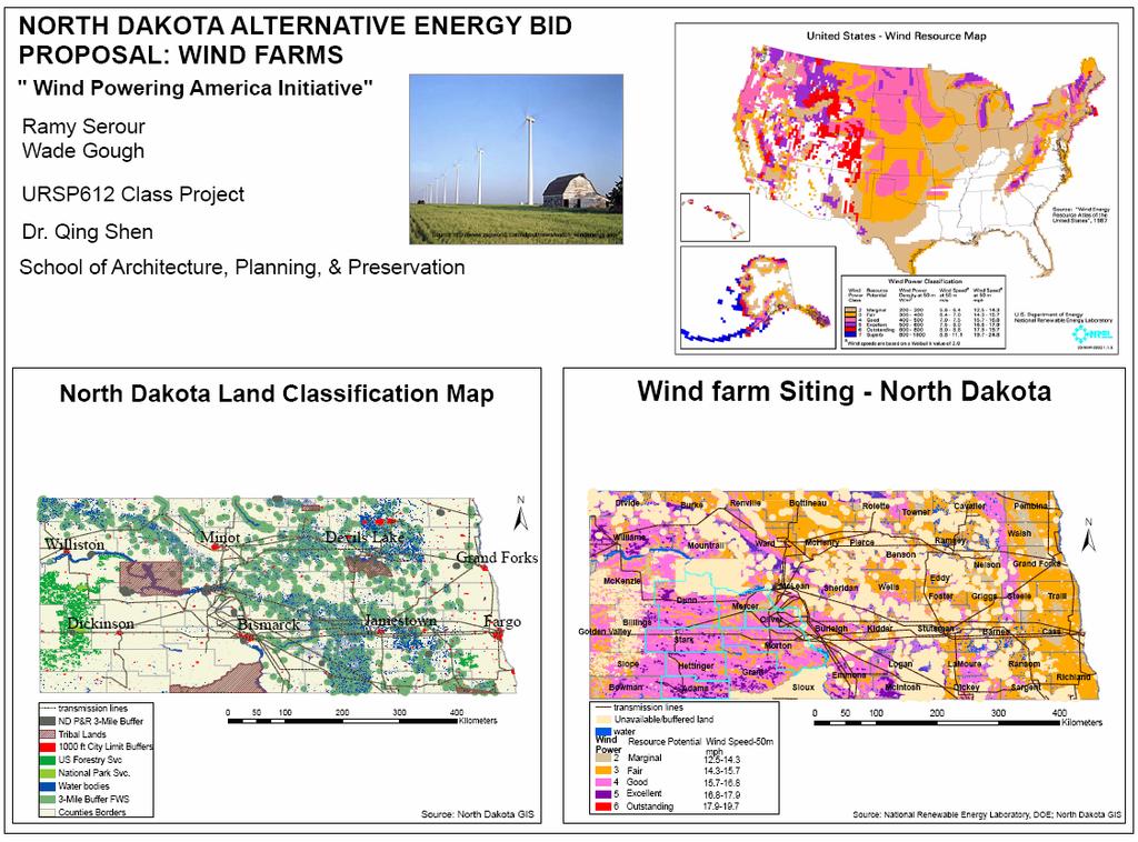
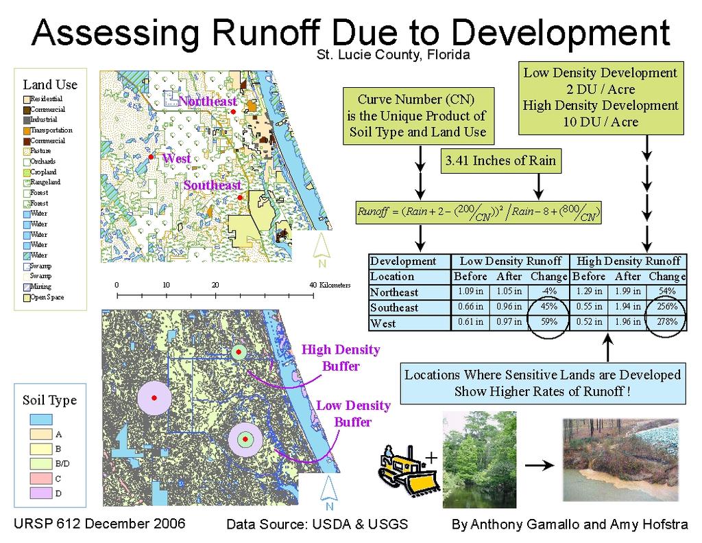
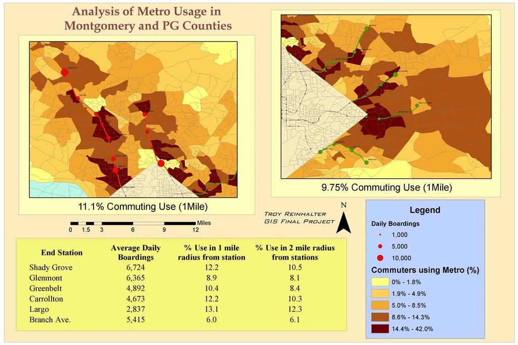
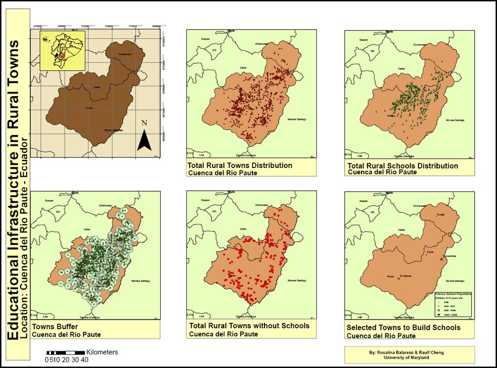
34 Examples of Final Project Maryland s renewable resource potential Locating wind farms in North Dakoda Assessing surface runoff due to development Analysis of metro usage in Montgomery and Prince George s counties Education infrastructure in Ecuador Others
35 Maryland s Renewable Resource Potential Drew Ronneberg URSP 612 Final Project Fall 2005
36 Maryland s Current Power Consumption Thermal Electricity Total 31.3 GW 5.5 GW 36.8 GW Can Maryland Meet its Current Power Needs With Renewable Energy Resources?
37 Maryland s Wind Resource Wind Class Value 1 ±
38 Maryland s Solar Resource Average Solar Energy Density (W/m2) ±
39 Maryland s Biomass Resource Land Type Farmland Non-Farmland ±
40 Maryland s Land Use- Land Cover Maryland's Land Uses Residential/Urban Commercial Industrial Institutional Extractive Open Urban Land Farmland Pastureland Feedlots Forests Water Wetlands
41 Methodology Rasterize land use and power density maps to 100mx100m grids Calculate net power density for each renewable resource (W/m2) Figure out compatible/incompatible land uses for 2 scenarios (restrictive and unrestrictive) Aggregate power densities to calculate statewide renewable resource potential
42 Net Energy Ratios Energy Output Net Energy Ratio = Energy Feedback Energy System Wind Solar-PV Biomass Net Energy Ratio
43 Net Power Densities of Renewable Energy Systems Wind ranges from 1 to 2 W/m2 Solar ranges from W/m2 Biomass is approximately 0.08 W/m2
44 Restrictive Land Use Scenario No windmills in water Only class 4 and above areas permitted Solar permitted on 0.5% of land mass in urban/residential areas Biomass on 20% of agricultural land
45 Unrestrictive Land Use Scenario Windmills permitted in Class 3 and above Solar allowed on all compatible land uses, including replacing 20% of the forest with solar panels Biomass on 20% of agricultural land
46 Wind under Restrictive and Unrestrictive Land Use Scenarios Restrictive Land Use ± Unrestrictive Land Use


47 Solar-PV under Restrictive and Unrestrictive Land Use Scenarios Restrictive Land Use ± Unrestrictive Land Use
48 Biomass under Restrictive and Unrestrictive Land Use Scenarios Restrictive Land Use ± Unrestrictive Land Use

49 Power Density Map For Restricted Land Use Power Density W/m2 ± High : 1.60 Low : 0.0
50 Restricted Land Use Scenario Total Power Output Percentage of Current Consumption Percentage of Maryland s Land Required Percentage of Power from Wind Percentage of Power from Solar/PV Percentage of Power from Biomass 0.6 GW 1.5% 6.5% 7.0% 63.5% 29.5%
51 Power Density Map For Unrestricted Land Use ± Power Density W/m2 High : Low : 0
52 Unrestricted Land Use Scenario Total Power Output Percentage of Current Consumption Percentage of Maryland s Land Required Percentage of Power from Wind Percentage of Power from Solar/PV Percentage of Power from Biomass 12.4 GW 33.7% 34.4% 40.4% 58.2% 1.4%
53 Conclusions Land requirements for renewable energy systems are enormous Even taking up 35% of land, Maryland s renewable energy potential is much less than current energy consumption Renewables can only contribute a small fraction to our energy needs Without fossil fuels/nuclear, our economy MUST contract Oil/natural gas will peak soon and then decline
54 Ultimate Conclusion Our Present Economy is Unsustainable Economic Growth is Unsustainable We are planning for the Wrong Future We need to Plan For Economic Contraction
55
56
57
58
59 5. Future Development of GIS Education in Urban Planning Programs
60 Encouraging Trends Information technology and spatial data of various kinds are widely accessible GIS is becoming increasingly important in urban planning Advanced GIS methods are finding useful applications in urban planning Promising new developments in spatial data collection; spatial modeling; location-based services Urban planning faculty and students are increasingly technology-savvy
61 Remaining Issues (I) Lack of consensus on the basic content of GIS courses for urban planning students Learning commercial software functionalities (e.g. ArcGIS) vs. learning fundamental concepts and methods Mapping vs. spatial analysis, modeling, and exploration of potential new applications to urban planning Examining location and distance-based spatial relationships vs. exploring technology-modified spatial relationships
62 Remaining Issues (II) Students needs for GIS education are changing Faculty resource for teaching GIS within urban planning programs is also changing GIS knowledge is expanding and becoming increasingly multi-disciplinary New spatial phenomena of concern for urban planners (firm location, service provision, security and possible disruptions of transportation systems, etc)
63 Remaining Issues (III) Lack of critical mass for learning and teaching advanced GIS within urban planning programs Most urban planning students will only be interested in the basics of GIS Most urban planning faculty will not be involved in cutting-edge research in GIS Most urban planning programs will continue to rely on other departments to offer advanced GIS courses
64 Standard GIS Curriculum and Course Materials for Urban Planning? If the answer is yes, who should develop them? A function of NCGIA or UCGIS? A function of ACSP? How should the learning be connected with other urban planning courses? Relating GIS education to urban planning issues Incorporating urban planning methods into GIS education
65 University-Level Coordination in GIS Education and Research? As long as there are programs that rely on other departments to offer GIS courses, university-level coordination is desirable Seeking institutional support and funding - Effective coordination requires incentives for participation Coordination effort may not be sustainable without secure funding Experiences of University of Maryland GIS people and spatial analysis group
66 Program-Level Adaptation to the Changing Needs for GIS Education? Faculty appointment Updating curriculum and program s areas of concentration Customizing GIS for urban planning education?
67 Thanks You!
Techniques for Science Teachers: Using GIS in Science Classrooms.
 Techniques for Science Teachers: Using GIS in Science Classrooms. After ESRI, 2008 GIS A Geographic Information System A collection of computer hardware, software, and geographic data used together for
What is GIS? G: Geographic, Geospatial, Geo
 GEOG 488/588: GIS I Introduction Instructor: Geoffrey Duh TA: David Graves What is GIS? G: Geographic, Geospatial, Geo Alternatives: Spatial Information Systems, Land Information Systems Geography diverse
geographic patterns and processes are captured and represented using computer technologies
 Proposed Certificate in Geographic Information Science Department of Geographical and Sustainability Sciences Submitted: November 9, 2016 Geographic information systems (GIS) capture the complex spatial
Welcome to NR502 GIS Applications in Natural Resources. You can take this course for 1 or 2 credits. There is also an option for 3 credits.
 Welcome to NR502 GIS Applications in Natural Resources. You can take this course for 1 or 2 credits. There is also an option for 3 credits. The 1st credit consists of a series of readings, demonstration,
GIS = Geographic Information Systems;
 What is GIS GIS = Geographic Information Systems; What Information are we talking about? Information about anything that has a place (e.g. locations of features, address of people) on Earth s surface,
Introduction to GIS (GEOG 401) Spring 2014, 3 credit hours
 Spring 2014, 3 credit hours") Introduction to GIS (GEOG 401) Spring 2014, 3 credit hours Instructors: Guangxing Wang, Ph.D. Email: gxwang@siu.edu Phone: (618) 453-6017 Office: 4442 Faner Hall Office hours: M& W&F 9:00am-11:00am or
Introduction to GIS (GEOG 401) Spring 2014, 3 credit hours Instructors: Guangxing Wang, Ph.D. Email: gxwang@siu.edu Phone: (618) 453-6017 Office: 4442 Faner Hall Office hours: M& W&F 9:00am-11:00am or
1. Omit Human and Physical Geography electives (6 credits) 2. Add GEOG 677:Internet GIS (3 credits) 3. Add 3 credits to GEOG 797: Final Project
 2. Add GEOG 677:Internet GIS (3 credits) 3. Add 3 credits to GEOG 797: Final Project") The Department of Geography and the Office of Professional Studies propose to modify the Master of Professional Studies in Geospatial Information Sciences (GIS) as follows: 1. Omit Human and Physical Geography
The Department of Geography and the Office of Professional Studies propose to modify the Master of Professional Studies in Geospatial Information Sciences (GIS) as follows: 1. Omit Human and Physical Geography
Diffusion of GIS in Public Policy Doctoral Program
 Diffusion of GIS in Public Policy Doctoral Program By Fulbert Namwamba PhD Southern University This presentation demonstrate how GIS was introduced in the Public Policy Doctoral Program at Southern University,
GEOGRAPHY MA, ASSESSMENT REPORT AY
 GEOGRAPHY MA, ASSESSMENT REPORT AY2012-2013 Programs: Geography MA Options Department: GSHAA Assessment Instruments and Student Outcomes This is an assessment report on three MA options in Geography in
NR402 GIS Applications in Natural Resources
 NR402 GIS Applications in Natural Resources Lesson 1 Introduction to GIS Eva Strand, University of Idaho Map of the Pacific Northwest from http://www.or.blm.gov/gis/ Welcome to NR402 GIS Applications in
Lab Assistant: Kathy Tang Office: SSC 2208 Phone: ext
 The University of Western Ontario Department of Geography GEOGRAPHY 9110B: Introduction to Geographic Information Systems Lecture: Thursday 11:30 1:30pm, SSC #1004 Lab: Thursday 2:30 4:30pm, SSC #1316A
Joanne N. Halls, PhD Dept. of Geography & Geology David Kirk Information Technology Services
 Joanne N. Halls, PhD Dept. of Geography & Geology David Kirk Information Technology Services Geographic Information Systems manage and analyze data to solve spatial problems. Real World Abstraction Analysis
Esri and GIS Education
 Esri and GIS Education Organizations Esri Users 1,200 National Government Agencies 11,500 States & Regional Agencies 30,800 Cities & Local Governments 32,000 Businesses 8,500 Utilities 12,600 NGOs 11,000
Dr. Stephen J. Walsh Department of Geography, UNC-CH Fall, 2007 Monday 3:30-6:00 pm Saunders Hall Room 220. Introduction
 Geographic Information Systems Geography 491 Dr. Stephen J. Walsh Department of Geography, UNC-CH Fall, 2007 Monday 3:30-6:00 pm Saunders Hall Room 220 Introduction Organizations that have a planning,
Teaching GIS for Land Surveying
 Teaching GIS for Land Surveying Zhanjing (John) Yu Evergreen Valley College, San Jose, California James Crossfield California State University at Fresno, Fresno California 7/13/2006 1 Outline of the Presentation
HGP 470 GIS and Advanced Cartography for Social Science
 HGP 470 GIS and Advanced Cartography for Social Science Winter 2014 Instructor: Office: Tory 3-115 Telephone: 780-248-5758 E-mail: vukicevi@ualberta.ca Office hours: By appointment LECTURES AND LABS Lectures/Labs:
Creating a Staff Development Plan with Esri
 Creating a Staff Development Plan with Esri Michael Green David Schneider Guest Presenter: Shane Feirer, University of California Esri UC 2014 Technical Workshop Agenda What is a Staff Development Plan?
International Development
 International Development Office: The Payson Center for International Development and Technology Transfer, 300 Hébert Hall Phone: 504-865-5240 Fax: 504-865-5241 Website: www.payson.tulane.edu/ Program
COURSE INTRODUCTION & COURSE OVERVIEW
 week 1 COURSE INTRODUCTION & COURSE OVERVIEW topics of the week Instructor introduction Students introductions Course logistics Course objectives Definition of GIS The story of GIS introductions Who am
Introduction to Geographic Information Systems
 Geog 58 Introduction to Geographic Information Systems, Fall, 2003 Page 1/8 Geography 58 Introduction to Geographic Information Systems Instructor: Lecture Hours: Lab Hours: X-period: Office Hours: Classroom:
Understanding Geographic Information System GIS
 Understanding Geographic Information System GIS What do we know about GIS? G eographic I nformation Maps Data S ystem Computerized What do we know about maps? Types of Maps (Familiar Examples) Street Maps
GEOG 508 GEOGRAPHIC INFORMATION SYSTEMS I KANSAS STATE UNIVERSITY DEPARTMENT OF GEOGRAPHY FALL SEMESTER, 2002
 GEOG 508 GEOGRAPHIC INFORMATION SYSTEMS I KANSAS STATE UNIVERSITY DEPARTMENT OF GEOGRAPHY FALL SEMESTER, 2002 Course Reference #: 13210 Meeting Time: TU 2:05pm - 3:20 pm Meeting Place: Ackert 221 Remote
LEHMAN COLLEGE OF THE CITY UNIVERSITY OF NEW YORK. 1. Type of Change: Change in Degree Requirements
 Alpha Number: Hegis Code 1214 Program Code: 30600 1. Type of Change: Change in Degree Requirements 2. From: [The curriculum consists of 45 graduate credits and includes core courses, an area of specialization,
Rural Louisiana. A quarterly publication of the Louisiana Tech Rural Development Center
 Rural Louisiana A quarterly publication of the Louisiana Tech Rural Development Center Volume 4, No. 1, Fall 2009 Editor: Aaron K. Lusby Director, Asst. Professor Newsletter design: Stephanie Tidwell Student
ESRI educational site license in Bahir Dar University. Tegegn Molla Abebe Mengaw Geospatial Data and Technology Center, BDU
 ESRI educational site license in Bahir Dar University Tegegn Molla Abebe Mengaw Geospatial Data and Technology Center, BDU September, 2016 Mission, Vision Purpose and Values of the GDTC Mission of GDTC
Pathways. Pathways through the Geography Major
 Pathways through the Major majors may structure their course selections around a sub-field of. Pathways are suggestions for classes in, in related disciplines, and skills training. Each pathway includes
2018 ESRI Education Summit. San Diego. California. Sunday July 8 th 2018 Harper College, Palatine, Illinois, USA Dr. Tong Cheng (Biology), Dr.
, Dr.") 2018 ESRI Education Summit. San Diego. California. Sunday July 8 th 2018 Harper College, Palatine, Illinois, USA Dr. Tong Cheng (Biology), Dr. James Gramlich (Sociology), Mukila Maitha (Geography), Dr.
2018 ESRI Education Summit. San Diego. California. Sunday July 8 th 2018 Harper College, Palatine, Illinois, USA Dr. Tong Cheng (Biology), Dr. James Gramlich (Sociology), Mukila Maitha (Geography), Dr.
Geographic Systems and Analysis
 Geographic Systems and Analysis New York University Robert F. Wagner Graduate School of Public Service Instructor Stephanie Rosoff Contact: stephanie.rosoff@nyu.edu Office hours: Mondays by appointment
GIS and Community Health. GIS and Community Health. Institutional Context and Interests in GIS Development. GIS and Community Health
 GIS and Community Health GIS and Community Health Some critiques of GIS emphasize the potentially harmful social consequences of the diffusion of GIS technology, including reinforcing the power of state
John Laznik 273 Delaplane Ave Newark, DE (302)
") Office Address: John Laznik 273 Delaplane Ave Newark, DE 19711 (302) 831-0479 Center for Applied Demography and Survey Research College of Human Services, Education and Public Policy University of Delaware
Office Address: John Laznik 273 Delaplane Ave Newark, DE 19711 (302) 831-0479 Center for Applied Demography and Survey Research College of Human Services, Education and Public Policy University of Delaware
Introduction to the 176A labs and ArcGIS Purpose of the labs
 Introduction to the 176A labs and ArcGIS Purpose of the labs Acknowledgement: Slides by David Maidment, U Texas-Austin and Francisco Olivera (TAMU) Hands-on experience with a leading software package Introduction
GIST 4302/5302: Spatial Analysis and Modeling Lecture 1: Overview
 GIST 4302/5302: Spatial Analysis and Modeling Lecture 1: Overview Guofeng Cao www.myweb.ttu.edu/gucao Department of Geosciences Texas Tech University guofeng.cao@ttu.edu Fall 2017 Texas Tech GIS Graduate
Introduction to GIS. Geol 4048 Geological Applications of Remote Sensing
 Introduction to GIS Geol 4048 Geological Applications of Remote Sensing GIS History: Before Computers GIS History Using maps for a long time Dr. Roger F. Tomlinson Father of GIS He was an English geographer
School of Geography and Geosciences. Head of School Degree Programmes. Programme Requirements. Modules. Geography and Geosciences 5000 Level Modules
 School of Geography and Geosciences Head of School Degree Programmes Graduate Diploma: Dr W E Stephens Health Geography Research Environmental History and Policy (see School of History) M.Res.: M.Litt.:
CAS GE 365 Introduction to Geographical Information Systems. The Applications of GIS are endless
 Spring 2007 CAS GE 365 Introduction to Geographical Information Systems Boston University Department of Geography and Environment The Applications of GIS are endless images from www.esri.com CAS GE 365
GIS at UCAR. The evolution of NCAR s GIS Initiative. Olga Wilhelmi ESIG-NCAR Unidata Workshop 24 June, 2003
 GIS at UCAR The evolution of NCAR s GIS Initiative Olga Wilhelmi ESIG-NCAR Unidata Workshop 24 June, 2003 Why GIS? z z z z More questions about various climatological, meteorological, hydrological and
BROADBAND DEMAND AGGREGATION: PLANNING BROADBAND IN RURAL NORTHERN CALIFORNIA
 BROADBAND DEMAND AGGREGATION: PLANNING BROADBAND IN RURAL NORTHERN CALIFORNIA Steven J. Steinberg, Ph.D a,b, *, Rebecca Degagne a, M.S., Michael Gough a a Institute for Spatial Analysis, Humboldt State
WELCOME. To GEOG 350 / 550 Introduction to Geographic Information Science: Third Lecture
 WELCOME To GEOG 350 / 550 Introduction to Geographic Information Science: Third Lecture 1 Lecture 3: Overview Geographic Information Systems (GIS) A brief history of GIS Sources of information for GIS
CHAPTER 22 GEOGRAPHIC INFORMATION SYSTEMS
 CHAPTER 22 GEOGRAPHIC INFORMATION SYSTEMS PURPOSE: This chapter establishes the administration and use of to improve the quality and accessibility of Department s spatial information and support graphical
INTEGRATING GEOSPATIAL PERSPECTIVES IN THE ANTHROPOLOGY CURRICULUM AT THE UNIVERSITY OF NEW MEXICO (UNM)
") INTEGRATING GEOSPATIAL PERSPECTIVES IN THE ANTHROPOLOGY CURRICULUM AT THE UNIVERSITY OF NEW MEXICO (UNM) VERONICA ARIAS HEATHER RICHARDS JUDITH VAN DER ELST DEPARTMENT OF ANTHROPOLOGY MARCH 2005 INTEGRATING
INTEGRATING GEOSPATIAL PERSPECTIVES IN THE ANTHROPOLOGY CURRICULUM AT THE UNIVERSITY OF NEW MEXICO (UNM) VERONICA ARIAS HEATHER RICHARDS JUDITH VAN DER ELST DEPARTMENT OF ANTHROPOLOGY MARCH 2005 INTEGRATING
Understanding China Census Data with GIS By Shuming Bao and Susan Haynie China Data Center, University of Michigan
 Understanding China Census Data with GIS By Shuming Bao and Susan Haynie China Data Center, University of Michigan The Census data for China provides comprehensive demographic and business information
MASTER OF APPLIED GEOGRAPHY (M.A.GEO.) MAJOR IN GEOGRAPHY RESOURCE AND ENVIRONMENTAL STUDIES
 MAJOR IN GEOGRAPHY RESOURCE AND ENVIRONMENTAL STUDIES") Master of Applied Geography (M.A.Geo.) Major in Geography Resource and Environmental Studies 1 MASTER OF APPLIED GEOGRAPHY (M.A.GEO.) MAJOR IN GEOGRAPHY RESOURCE AND ENVIRONMENTAL STUDIES Major Program
Master of Applied Geography (M.A.Geo.) Major in Geography Resource and Environmental Studies 1 MASTER OF APPLIED GEOGRAPHY (M.A.GEO.) MAJOR IN GEOGRAPHY RESOURCE AND ENVIRONMENTAL STUDIES Major Program
MASTER OF APPLIED GEOGRAPHY (M.A.GEO.) MAJOR IN GEOGRAPHIC INFORMATION SCIENCE
 MAJOR IN GEOGRAPHIC INFORMATION SCIENCE") Master of Applied Geography (M.A.Geo.) Major in Geographic Information Science 1 MASTER OF APPLIED GEOGRAPHY (M.A.GEO.) MAJOR IN GEOGRAPHIC INFORMATION SCIENCE Major Program The Master of Applied Geography
Master of Applied Geography (M.A.Geo.) Major in Geographic Information Science 1 MASTER OF APPLIED GEOGRAPHY (M.A.GEO.) MAJOR IN GEOGRAPHIC INFORMATION SCIENCE Major Program The Master of Applied Geography
The B.S.G.E. program is accredited by the Engineering Accreditation Commission of ABET,
 Geomatics Engineering The program of study leading to the Bachelor of Science in Geomatics Engineering (B.S.G.E.) deals with designing solutions to measure, map, model, analyze and graphically display
Lecture 1 Introduction to GIS. Dr. Zhang Spring, 2017
 Lecture 1 Introduction to GIS Dr. Zhang Spring, 2017 Topics of the course Using and making maps Navigating GIS Map design Working with spatial data Geoprocessing Spatial data infrastructure Digitizing
ARCGIS TRAINING AT KU GIS LABS: INTRODUCTION TO GIS: EXPLORING ARCCATALOG AND ARCGIS TOOLS
 PHASE 1_3 rd SESSION ARCGIS TRAINING AT KU GIS LABS: INTRODUCTION TO GIS: EXPLORING ARCCATALOG AND ARCGIS TOOLS 3 rd SESSION REPORT: 25 TH -27 TH JUNE 2014 SCHOOL OF ENVIRONMENTAL STUDIES COMPUTER LAB
Massachusetts Institute of Technology Department of Urban Studies and Planning
 Massachusetts Institute of Technology Department of Urban Studies and Planning 11.520: A Workshop on Geographic Information Systems 11.188: Urban Planning and Social Science Laboratory GIS Principles &
Introduction to the 176A labs and ArcGIS
 Introduction to the 176A labs and ArcGIS Acknowledgement: Slides by David Maidment, U Texas-Austin and Francisco Olivera (TAMU) Purpose of the labs Hands-on experience with one software pakage Introduction
GRADUATE CERTIFICATE PROGRAM
 GRADUATE CERTIFICATE PROGRAM GEOGRAPHIC INFORMATION SCIENCES Department of Geography University of North Carolina Chapel Hill Conghe Song, Director csong @email.unc.edu 919-843-4764 (voice) 919-962-1537
ARCGIS TRAINING AT KU GIS LABS: INTRODUCTION TO GIS: EXPLORING ARCCATALOG AND ARCGIS TOOLS
 PHASE 1_4 th SESSION ARCGIS TRAINING AT KU GIS LABS: INTRODUCTION TO GIS: EXPLORING ARCCATALOG AND ARCGIS TOOLS 4 th SESSION REPORT: 30 TH JUNE - 2 ND JULY SCHOOL OF ENVIRONMENTAL STUDIES COMPUTER LAB
WHAT YOU WILL LEARN TODAY
 WHAT YOU WILL LEARN TODAY Overview of the new QGIS Academy Curriculum Background on curriculum development Curriculum alignment with national standards Description of the five GIS courses Details of the
Science, General. Program Description
 Program Description This program is designed to provide students with a basic science background, preparing them to move into a curriculum at a four-year institution leading to a degree in such fields
AP Human Geography Syllabus
 AP Human Geography Syllabus Textbook The Cultural Landscape: An Introduction to Human Geography. Rubenstein, James M. 10 th Edition. Upper Saddle River, N.J.: Prentice Hall 2010 Course Objectives This
COURSES OUTSIDE THE JOURNALISM SCHOOL
 COURSES OUTSIDE THE JOURNALISM SCHOOL Students are not limited to the science courses on this list and may select classes from additional specialties. In accordance with University policy, 400-level courses
GEOGRAPHIC INFORMATION SYSTEMS AND IT SOLUTIONS FOR THE ENVIRONMENT
 GEOGRAPHIC INFORMATION SYSTEMS AND IT SOLUTIONS FOR THE ENVIRONMENT Mission We focus on Solutions is a worldwide operating business offering Geographic Information Systems and IT solutions to assist environmental
GIS and Forest Engineering Applications FE 357 Lecture: 2 hours Lab: 2 hours 3 credits
 GIS and Forest Engineering Applications FE 357 Lecture: 2 hours Lab: 2 hours 3 credits Instructor: Michael Wing Assistant Professor Forest Engineering Department Oregon State University Peavy Hall 275
GeoHealth Applications Platform ESRI Health GIS Conference 2013
 GeoHealth Applications Platform ESRI Health GIS Conference 2013 Authors Thomas A. Horan, Ph.D. Professor, CISAT Director April Moreno Health GeoInformatics Ph.D. Student Brian N. Hilton, Ph.D. Clinical
Programme Study Plan
 Faculty of Social and Life Sciences Programme Study Plan Geographic Information Systems Programme Code: Programme Title: TGLIT Engineering: Surveying Technology and Geographical IT Credits: 180 Programme
GEOGRAPHY (GEOGRPHY) Geography (GEOGRPHY) 1
 Geography (GEOGRPHY) 1") Geography (GEOGRPHY) 1 GEOGRAPHY (GEOGRPHY) GEOGRPHY 1040 Planet Earth 4 Credits The features of the natural environment (lithosphere, atmosphere and hydrosphere); their character, distribution, origin
Geography (GEOGRPHY) 1 GEOGRAPHY (GEOGRPHY) GEOGRPHY 1040 Planet Earth 4 Credits The features of the natural environment (lithosphere, atmosphere and hydrosphere); their character, distribution, origin
WHAT YOU WILL LEARN TODAY
 WHAT YOU WILL LEARN TODAY Overview of the new GeoAcademy Curriculum Background on curriculum development Curriculum alignment with national standards Description of the five GIS courses Details of the
UNDER REVIEW. Abstract
 UNDER REVIEW Getting To Know ArcGIS Desktop By: Ormsby, Napoleon, Burke, Groessl, and Bowden, (2010). Format: (Softcover, 592 pp. ISBN: 9781589482609) Publisher: Redlands, California: ESRI Press Abstract
GIST 4302/5302: Spatial Analysis and Modeling
 GIST 4302/5302: Spatial Analysis and Modeling Spring 2014 Lectures: Tuesdays & Thursdays 2:00pm-2:50pm, Holden Hall 00038 Lab sessions: Tuesdays or Thursdays 3:00pm-4:50pm or Wednesday 1:00pm-2:50pm, Holden
GIST 4302/5302: Spatial Analysis and Modeling
 GIST 4302/5302: Spatial Analysis and Modeling Spring 2016 Lectures: Tuesdays & Thursdays 12:30pm-1:20pm, Science 234 Labs: GIST 4302: Monday 1:00-2:50pm or Tuesday 2:00-3:50pm GIST 5302: Wednesday 2:00-3:50pm
Teaching GIS Technology at UW-Superior. Volume 9, Number 8: May 23, 2003
 Teaching GIS Technology at UW-Superior Volume 9, Number 8: May 23, 2003 William Bajjali University of Wisconsin, department of Biology and Earth Science, Superior, WI 54880 Abstract As educators, it is
GIST 4302/5302: Spatial Analysis and Modeling
 GIST 4302/5302: Spatial Analysis and Modeling Fall 2015 Lectures: Tuesdays & Thursdays 2:00pm-2:50pm, Science 234 Lab sessions: Tuesdays or Thursdays 3:00pm-4:50pm or Friday 9:00am-10:50am, Holden 204
ENV208/ENV508 Applied GIS. Week 1: What is GIS?
 ENV208/ENV508 Applied GIS Week 1: What is GIS? 1 WHAT IS GIS? A GIS integrates hardware, software, and data for capturing, managing, analyzing, and displaying all forms of geographically referenced information.
EEOS 465 / 627 Environmental Modeling with Raster GIS. David Tenenbaum EEOS 465 / 627 UMass Boston
 EEOS 465 / 627 Environmental Modeling with Raster GIS EEOS 465 / 627 Environmental Modeling with Raster GIS Course Description: This course consists of three parts: In the first four weeks, we will focus
CSISS Resources for Research and Teaching
 CSISS Resources for Research and Teaching Donald G. Janelle Center for Spatially Integrated Social Science University of California, Santa Barbara Montreal 26 July 2003 Workshop on Spatial Analysis for
GTECH 380/722 Analytical and Computer Cartography Hunter College, CUNY Department of Geography
 GTECH 380/722 Analytical and Computer Cartography Hunter College, CUNY Department of Geography Spring 2010 Wednesdays 5:35PM to 9:15PM Instructor: Doug Williamson, PhD Email: Douglas.Williamson@hunter.cuny.edu
GEOG 3340: Introduction to Human Geography Research
 GEOG 3340: Introduction to Human Geography Research Lecture 1: Course Overview Guofeng Cao www.myweb.ttu.edu/gucao Department of Geosciences Texas Tech University guofeng.cao@ttu.edu Fall 2015 Course Description
Molinaro Keyword: Geography. Associate Professors: Walasek, Ph.D.; (Chair), Wolf, Ph.D.
, Wolf, Ph.D.") 126 - Geography GENERAL INFO GRADUATE UNDREGRADUATE ADULT/NON-TRAD POLICIES STUDENT LIFE ADMISSIONS INTRODUCTION Degree Offered: Bachelor of Arts. Associate Professors: Walasek, Ph.D.; (Chair), Wolf, Ph.D.
126 - Geography GENERAL INFO GRADUATE UNDREGRADUATE ADULT/NON-TRAD POLICIES STUDENT LIFE ADMISSIONS INTRODUCTION Degree Offered: Bachelor of Arts. Associate Professors: Walasek, Ph.D.; (Chair), Wolf, Ph.D.
Bentley Map Advancing GIS for the World s Infrastructure
 Bentley Map Advancing GIS for the World s Infrastructure Presentation Overview Why would you need Bentley Map? What is Bentley Map? Where is Bentley Map Used? Red text signifies new things in Bentley Map
GEOGRAPHY (GE) Courses of Instruction
 Courses of Instruction") GEOGRAPHY (GE) GE 102. (3) World Regional Geography. The geographic method of inquiry is used to examine, describe, explain, and analyze the human and physical environments of the major regions of the
GEOGRAPHY (GE) GE 102. (3) World Regional Geography. The geographic method of inquiry is used to examine, describe, explain, and analyze the human and physical environments of the major regions of the
Dr.Sinisa Vukicevic Dr. Robert Summers
 Dr.Sinisa Vukicevic Dr. Robert Summers "Planning" means the scientific, aesthetic, and orderly disposition of land, resources, facilities and services with a view to securing the physical, economic and
GIS Applications on Environmental Education in Taiwan
 GIS Applications on Environmental Education in Taiwan Track: Education Authors: Yu-Chen Lai, Mei-Ling Yeh, Tien-Yin Chou Abstract GIS is a perfect vehicle to deliver environmental knowledge and spatial
CERTIFICATE PROGRAM IN
 CERTIFICATE PROGRAM IN GEOGRAPHIC INFORMATION SCIENCE Department of Geography University of Utah 260 S. Central Campus Dr., Rm 270 Salt Lake City, UT 84112-9155 801-581-8218 (voice); 801-581-8219 (fax)
Geog 469 GIS Workshop. Managing Enterprise GIS Geodatabases
 Geog 469 GIS Workshop Managing Enterprise GIS Geodatabases Outline 1. Why is a geodatabase important for GIS? 2. What is the architecture of a geodatabase? 3. How can we compare and contrast three types
Advanced Readings. Environment and Land Use Concentration The following seminars and studios would apply
 Community Development and Housing Concentration URP 720 Urban Housing Policies URP 722 Community Development and Housing URP 724 Urban Revitalization Studio URP 726 Citizen Participation Strategies URP
HGP 470 GIS and Advanced Cartography in Social Science
 HGP 470 GIS and Advanced Cartography in Social Science Fall 2012 Instructor: Dr Sinisa J. Vukicevic Office: Tory 3-115 Telephone: 780-248-5758 E-mail: vukicevi@ualberta.ca Office hours: Wednesday 10:00
Strategic Plan for the Geospatial Teaching, Research, and Outreach in CNR. The CNR Geospatial Steering Committee, March 31, 2008
 Strategic Plan for the Geospatial Teaching, Research, and Outreach in CNR The CNR Geospatial Steering Committee, March 31, 2008 Current Mission for the Geospatial Learning Center Established in 1995, the
Geog418: Introduction to GIS Fall 2011 Course Syllabus. Textbook: Introduction to Geographic Information Systems edited by Chang (6th ed.
 Geog418: Introduction to GIS Fall 2011 Course Syllabus AH 1320 3:30 4:45 p.m.tr Instructor: Dr. Shunfu Hu Office: AH1413 Telephone 650-2281 Office hours: 10:00 11:00 a.m. TR or by appointment (shu@siue.edu)
Introduction-Overview. Why use a GIS? What can a GIS do? Spatial (coordinate) data model Relational (tabular) data model
 data model Relational (tabular) data model") Introduction-Overview Why use a GIS? What can a GIS do? How does a GIS work? GIS definitions Spatial (coordinate) data model Relational (tabular) data model intro_gis.ppt 1 Why use a GIS? An extension
Introduction-Overview Why use a GIS? What can a GIS do? How does a GIS work? GIS definitions Spatial (coordinate) data model Relational (tabular) data model intro_gis.ppt 1 Why use a GIS? An extension
SOUTH DAKOTA BOARD OF REGENTS. Academic and Student Affairs ******************************************************************************
 SOUTH DAKOTA BOARD OF REGENTS Academic and Student Affairs AGENDA ITEM: 7 C (4) DATE: June 28-30, 2016 ****************************************************************************** SUBJECT: New Minor:
Advanced Placement Human Geography
 Advanced Placement Human Geography I. Overview of the Course The purpose of the Advanced Placement (AP) Human Geography course is to introduce students to the systematic study of patterns and processes
FIRE DEPARMENT SANTA CLARA COUNTY
 DEFINITION FIRE DEPARMENT SANTA CLARA COUNTY GEOGRAPHIC INFORMATION SYSTEM (GIS) ANALYST Under the direction of the Information Technology Officer, the GIS Analyst provides geo-spatial strategic planning,
UNIT 4: USING ArcGIS. Instructor: Emmanuel K. Appiah-Adjei (PhD) Department of Geological Engineering KNUST, Kumasi
 Department of Geological Engineering KNUST, Kumasi") UNIT 4: USING ArcGIS Instructor: Emmanuel K. Appiah-Adjei (PhD) Department of Geological Engineering KNUST, Kumasi Getting to Know ArcGIS ArcGIS is an integrated collection of GIS software products ArcGIS
UNIT 4: USING ArcGIS Instructor: Emmanuel K. Appiah-Adjei (PhD) Department of Geological Engineering KNUST, Kumasi Getting to Know ArcGIS ArcGIS is an integrated collection of GIS software products ArcGIS
The Importance of Spatial Literacy
 The Importance of Spatial Literacy Dr. Michael Phoenix GIS Education Consultant Taiwan, 2009 What is Spatial Literacy? Spatial Literacy is the ability to be able to include the spatial dimension in our
PLANNING (PLAN) Planning (PLAN) 1
 Planning (PLAN) 1") Planning (PLAN) 1 PLANNING (PLAN) PLAN 500. Economics for Public Affairs Description: An introduction to basic economic concepts and their application to public affairs and urban planning. Note: Cross-listed
Planning (PLAN) 1 PLANNING (PLAN) PLAN 500. Economics for Public Affairs Description: An introduction to basic economic concepts and their application to public affairs and urban planning. Note: Cross-listed
Geography (GEOG) Courses
 Courses") Geography (GEOG) 1 Geography (GEOG) Courses GEOG 100. Introduction to Human Geography. 4 (GE=D4) Introduction to the global patterns and dynamics of such human activities as population growth and movements,
Geography (GEOG) 1 Geography (GEOG) Courses GEOG 100. Introduction to Human Geography. 4 (GE=D4) Introduction to the global patterns and dynamics of such human activities as population growth and movements,
GIScience: Current Technology. Michael F. Goodchild University of California Santa Barbara
 GIScience: Current Technology Michael F. Goodchild University of California Santa Barbara What is a GIS? A class of software designed to handle geographic information and perform virtually any conceivable
Technical Drafting, Geographic Information Systems and Computer- Based Cartography
 Technical Drafting, Geographic Information Systems and Computer- Based Cartography Project-Specific and Regional Resource Mapping Services Geographic Information Systems - Spatial Analysis Terrestrial
Montgomery County Community College GEO 210 Introduction to Geographic Information Systems (GIS) 3-2-2
 3-2-2") Montgomery County Community College GEO 210 Introduction to Geographic Information Systems (GIS) 3-2-2 COURSE DESCRIPTION: This introduction to Geographic Information Systems is structured to develop skills
Montgomery County Community College GEO 210 Introduction to Geographic Information Systems (GIS) 3-2-2 COURSE DESCRIPTION: This introduction to Geographic Information Systems is structured to develop skills
ENVIRONMENT AND NATURAL RESOURCES 3700 Introduction to Spatial Information for Environment and Natural Resources. (2 Credit Hours) Semester Syllabus
 Semester Syllabus") ENVIRONMENT AND NATURAL RESOURCES 3700 Introduction to Spatial Information for Environment and Natural Resources COURSE INSTRUCTOR: Dr. Kris Jaeger Assistant Professor 359 Kottman Hall (Mondays and Tuesdays)
ENVIRONMENT AND NATURAL RESOURCES 3700 Introduction to Spatial Information for Environment and Natural Resources COURSE INSTRUCTOR: Dr. Kris Jaeger Assistant Professor 359 Kottman Hall (Mondays and Tuesdays)
Summary Description Municipality of Anchorage. Anchorage Coastal Resource Atlas Project
 Summary Description Municipality of Anchorage Anchorage Coastal Resource Atlas Project By: Thede Tobish, MOA Planner; and Charlie Barnwell, MOA GIS Manager Introduction Local governments often struggle
WEB-BASED SPATIAL DECISION SUPPORT: TECHNICAL FOUNDATIONS AND APPLICATIONS
 WEB-BASED SPATIAL DECISION SUPPORT: TECHNICAL FOUNDATIONS AND APPLICATIONS Claus Rinner University of Muenster, Germany Piotr Jankowski San Diego State University, USA Keywords: geographic information
Geo Business Gis In The Digital Organization
 We have made it easy for you to find a PDF Ebooks without any digging. And by having access to our ebooks online or by storing it on your computer, you have convenient answers with geo business gis in
Introduction to Geographic Information Science. Updates/News. Last Lecture 1/23/2017. Geography 4103 / Spatial Data Representations
 Geography 4103 / 5103 Introduction to Geographic Information Science Spatial Data Representations Updates/News Waitlisted students First graded lab this week: skills learning Instructional labs vs. independence
Using MAGIC to Access Spatial Imagery: Putting ER Mapper Image Web Server, ArcIMS and MrSID to work in your Library
 Using MAGIC to Access Spatial Imagery: Putting ER Mapper Image Web Server, ArcIMS and MrSID to work in your Library Patrick McGlamery Shirley Quintero University of Connecticut Libraries Building the Connecticut
No. of Days. Building 3D cities Using Esri City Engine ,859. Creating & Analyzing Surfaces Using ArcGIS Spatial Analyst 1 7 3,139
 Q3 What s New? Creating and Editing Data with ArcGIS Pro Editing and Maintaining Parcels Using ArcGIS Spatial Analysis Using ArcGIS Pro User Workflows for ArcGIS Online Organizations Q3-2018 ArcGIS Desktop
LEHMAN COLLEGE CITY UNIVERSITY OF NEW YORK DEPARTMENT OF ENVIRONMENTAL, GEOGRAPHIC, AND GEOLOGICAL SCIENCES CURRICULAR CHANGE
 LEHMAN COLLEGE CITY UNIVERSITY OF NEW YORK DEPARTMENT OF ENVIRONMENTAL, GEOGRAPHIC, AND GEOLOGICAL SCIENCES CURRICULAR CHANGE Hegis Code: 2206.00 Program Code: 452/2682 1. Type of Change: New Course 2.