Digitalization in Road Construction. K.V. Mahadev
|
|
|
- Erik Dawson
- 5 years ago
- Views:
Transcription

1 Digitalization in Road Construction K.V. Mahadev


2 Who are We???? LARSEN & TOUBRO LIMITED Founded in April 1938 by Mr. Henning Holck-Larsen & Mr. Soren K. Toubro.
 LLC Year of Incorporation -")
3 Local Presence LARSEN & TOUBRO (Oman) LLC Year of Incorporation
4 Core Business Areas B&F PT&D TI Mega Townships Housing development Commercial Buildings Institutional Buildings Cement Plants Hangar Facilities MEP Works Transmission lines EHV & HV Substations EHV & HV Cabling Works Overhead Lines Industrial Electrification Bridges Roads Runways M&M Industrial Projects & Utilities WET Water Supply Projects

5 OUR VISION

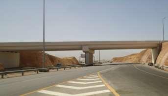
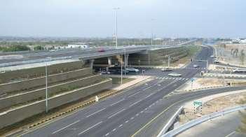
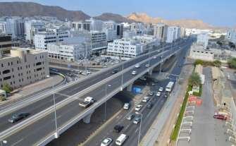
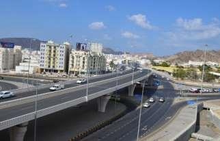
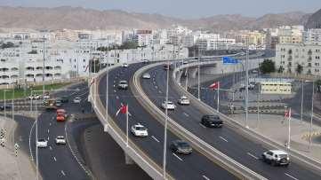
6 Completed Infrastructure Projects Al Khodh Interchange Dualization of Ghala Ansab Road Al Athaiba Interchange Darsait Wadi kabir Flyover


7 Ongoing Projects Al Batinah Express way Mahala-Ghubbrat Al Tam- Ismaiyah Road Project Dualization of Bid Bid Sur

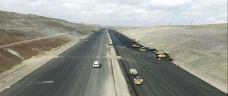
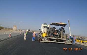
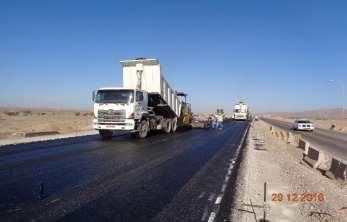
8 Our Project Title : Dualization of Bid Bid Sur Road. Location :North & South Al Sharqiya. This project links Bidbid with Sur, via Wilayat Al Qabil, Bidiya, Wadi Bani Khalid and Al Kamil. It consist of 76kms of 6 Lane Asphalt road with 8 Interchanges and 252 no s Cross drainage structures and is currently in construction phase. Project Layout on Google Earth Platform

9 Challenges Encountered Project being located in the vicinity of Desert, day to day challenges 1. Accessing Borrow areas 2. Real time vehicle movement monitoring. 3. Elevation and Density monitoring. 4. Manpower Productivity monitoring. 5. Project Progress monitoring.
10 Agenda for the day Construction is one of the major industries that deal directly with geography/nature for its productivity. Though the type of constructions are varying like Buildings, Factories, Roadways, Railways, Metros, Ports, Power transmission, Solar energy, Water supply, Effluent treatment, Hydro & Nuclear Power generation, etc. are being constructed on, above or below the earth. The unplanned and haphazard production of infrastructure/building construction causes imbalanced and unfriendly relation to environment and this creates a big threat to peace, prosperity, health and quality of human-environment interactive arena 1. In this perspective, Geospatial Technology section of L&T Construction, exploring the benefits of GIS at enterprises level through various construction industry related case studies 1.

11 Pre construction Stage Location, administrative boundary, existing land use, soil characteristics, geology & geomorphology, climatic & terrain conditions of in and around the site, required built-up area, bill of quantity, manpower, rate and availability of construction materials at nearby locations are some of the spatial & aspatial information that require at the tendering/bidding stage of a construction projects can be easily monitored. 1 If preconstruction stage monitoring or Reconnaissance is done, 3D maps of the area can be developed and it gives a broad idea of what needs to be taken care off during construction as it highlights areas of probable issue/danger, areas of probable delays. Effective measures can be taken in advance to minimize the risk or delays Some of the advantages are Mapping of Existing Habitation Ground water levels Mapping of existing utilities

12 Construction Stage During construction stage, if implemented these techniques can change the way of progress monitoring. Detailed and Real time monitoring can be done, these techniques reduce errors in reporting. Representative image for real time monitoring

13 Construction stage (2) Tracking of Vehicle movement It is a big challenge to keep a track of vehicles working on the construction site if it s a road project due to length of the project. Vehicles can be fitted with mapping devices which gives the location of the vehicle, real time tracking can be done. (These data can be used during settling of accounts of the vehicle in case of hired vehicles Some of the advantages of vehicle monitoring are Track vehicle movement in construction site Record ide time Track breakdown of the vehicles Record cycle time The performance of vehicles can be monitored in real time if this technology is implemented


14 Construction stage (3) Elevation and Density monitoring One of the biggest challenges in road construction is to maintain levels of the constructed surface. By using intelligent compactors the level of compaction can be evaluated and progress can be enhanced. Construction works can be completed at a faster pace. Advantages of monitoring levels are Accuracy and quality in construction. Completion of work at faster pace. Reduce human interference and errors in Controlling Elevations Reduction of cycle time in construction. (Construction, testing and inspection can be done simultaneously).
15 Post Construction stage Location based database technology of GIS has great extent of ability to effectively manage the assets. Effective as built drawings can be prepared on an interactive platform so that asset management becomes easy for both client and the contractor. Identification of assets, utilities and other constructed areas is made easy. Any damage to the finished product can be monitored real time. Some of the key advantages are Maintain data base of the project Real time Asset management To conclude in construction industry GIS acts as a blend of Geographic understanding, Management practices, engineering and technology and it reduces unwanted duplication of spatial information among various stages of design, execution and contract.

16 GIS implementation in L&T Construction Enterprise GIS based water utility information system 1 Development of GIS system for utility management was done with the help of ESRI. As a case study a small portion of water utility information was converted in to ESRI ArcGIS Geo Database and information system is developed. This allows the users to understand spatial relationship of their utility data with the existing geographic features.
17 Signing off To conclude In construction industry, GIS acts as a blend of Geographic understanding, Management practices, engineering and technology. It also reduces unwanted duplication of spatial information among various stages of design, execution and contract....thank You
Asset Management Planning. GIS and Asset Management Integration Readiness Assessment
 Asset Management Planning GIS and Asset Management Integration Readiness Assessment With too little data, you won t be able to make any conclusions that you trust. With loads of data you will find relationships
A Broad View of Geospatial Technology & Systems
 A Broad View of Geospatial Technology & Systems Pete Large Vice President, Trimble On the shoulders of giants 1 Since their time, our ability to generate geospatial information has grown exponentially
MODERNIZATION OF THE MUNICIPAL MAPPING USING HIGH END GNSS SYSTEM AND GIS SOFTWARE
 MODERNIZATION OF THE MUNICIPAL MAPPING USING HIGH END GNSS SYSTEM AND GIS SOFTWARE Mr. R. A. R. Khan Assistant Engineer, Sewerage Utility Management Centre (SUMC) Municipal Corporation Of Greater Mumbai
About the Author: Abstract:
 Geospatial Technology: A Tool to estimate revenue loss from JJ Clusters in Delhi and implementation of Delhi Govt. Social Welfare Schemes Authors Name: Anil Kumar Rai+, Pooja Yadav+ & Varun Prakash* +Amity
June 19 Huntsville, Alabama 1
 June 19 Huntsville, Alabama 1 Real-Time Geospatial Data: The Fusion of PI and ArcGIS Enabling Smarter Facilities Management OSIsoft and Esri Mapping and Location Analytics Platform Supporting Your Use
Systems Interoperability at the Port of Long Beach
 Systems Interoperability at the Port of Long Beach Tuesday, June 11, 2013 2:45 pm 4:00 pm, Garden Salon One, 2nd Fl. Presented by: Brien Green, Account Manager, Bentley Systems Daniel Lee, Business Analyst,
Systems Interoperability at the Port of Long Beach
 Systems Interoperability at the Port of Long Beach Tuesday, June 11, 2013 2:45 pm 4:00 pm, Garden Salon One, 2nd Fl. Presented by: Brien Green, Account Manager, Bentley Systems Daniel Lee, Business Analyst,
Copernicus Overview. Major Emergency Management Conference Athlone 2017
 Copernicus Overview Major Emergency Management Conference Athlone 2017 Copernicus is a European programme implemented by the European Commission. The services address six thematic areas: land, marine,
Maricopa County Department of Transportation (MCDOT) GIS Innovations in Transportation Asset Management
 GIS Innovations in Transportation Asset Management") Maricopa County Department of Transportation (MCDOT) GIS Innovations in Transportation Asset Management Presented By Steve Hossack, GIS Database Administrator 2018 ITE/IMSA Spring Conference Maricopa County
Maricopa County Department of Transportation (MCDOT) GIS Innovations in Transportation Asset Management Presented By Steve Hossack, GIS Database Administrator 2018 ITE/IMSA Spring Conference Maricopa County
Imagery and the Location-enabled Platform in State and Local Government
 Imagery and the Location-enabled Platform in State and Local Government Fred Limp, Director, CAST Jim Farley, Vice President, Leica Geosystems Oracle Spatial Users Group Denver, March 10, 2005 TM TM Discussion
Country Report On Sdi Activities In Singapore ( )
") UNITED NATIONS E/CONF.102/IP.4 ECONOMIC AND SOCIAL COUNCIL Nineteenth United Nations Regional Cartographic Conference for Asia and the Pacific Bangkok, 29 October 1 November 2012 Item 6(b) of the provisional
UNITED NATIONS E/CONF.102/IP.4 ECONOMIC AND SOCIAL COUNCIL Nineteenth United Nations Regional Cartographic Conference for Asia and the Pacific Bangkok, 29 October 1 November 2012 Item 6(b) of the provisional
2016 APWA Snow Conference. Web-based GIS for Municipal Snow Operations
 2016 APWA Snow Conference Web-based GIS for Municipal Snow Operations Christopher M. Cignoli, P.E. - Director of Public Works, Springfield, MA Bob Houldson - Director IT Services for the Department of
ESRI Survey Summit August Clint Brown Director of ESRI Software Products
 ESRI Survey Summit August 2006 Clint Brown Director of ESRI Software Products Cadastral Fabric How does Cadastral fit with Survey? Surveyors process raw field observations Survey measurements define high-order
Applications of GIS in Electrical Power System
 Applications of GIS in Electrical Power System Abdulrahman M. AL-Sakkaf 201102310 CRP 514 May 2013 Dr. Baqer M. AL-Ramadan Abstract GIS has been widely used in various areas and disciplines. This paper
Transforming the Maricopa County Department of Transportation (MCDOT) GIS-based Transportation Asset Inventory System June 30, 2016
 GIS-based Transportation Asset Inventory System June 30, 2016") Transforming the Maricopa County Department of Transportation (MCDOT) GIS-based Transportation Asset Inventory System June 30, 2016 Presented By Steve Hossack, GIS Database Administrator 2016 Esri User
Transforming the Maricopa County Department of Transportation (MCDOT) GIS-based Transportation Asset Inventory System June 30, 2016 Presented By Steve Hossack, GIS Database Administrator 2016 Esri User
GeoSpatial Water Distribution, Sanitary Sewer and Stormwater Network Modeling
 2009 Bentley Systems, Incorporated GeoSpatial Water Distribution, Sanitary Sewer and Stormwater Network Modeling Angela Battisti, Gary Griffiths Bentley Systems Inc Presenter Profile Angela Battisti, CE,
CAPE FARM MAPPER - an integrated spatial portal
 CAPE FARM MAPPER - an integrated spatial portal Skukuza Dr Mike Wallace June 2017 Overview of GIS applications in WCDoA Spatial information and technology has become indispensable across a wide range of
Presentation On GIS. Tarun Batra HoG-GIS Dhruba Banerjee - Team lead (Technical)
") Presentation On GIS Tarun Batra HoG-GIS Dhruba Banerjee - Team lead (Technical) Presentation Outline What is GIS? TPDDL s GIS Journey Component of GIS Project Phase of GIS GIS Applications GIS Landscape
Presentation On GIS Tarun Batra HoG-GIS Dhruba Banerjee - Team lead (Technical) Presentation Outline What is GIS? TPDDL s GIS Journey Component of GIS Project Phase of GIS GIS Applications GIS Landscape
Geography for the 2020 Round of Census
 Boundaries Key Census Data EA Id Population Male Female EA Id Area EA Id Num HH Avg HH size Geography for the 2020 Round of Census Linda Peters, Esri lpeters@esri.com Integration of Statistical and Geospatial
HOME NSGIS PORTS ENESGY DEMO CONTACT. Copyright NorthSouth GIS LLC, All rights reserved.
 A Practical Approach to GIS in Ports Company NorthSouth GIS LLC Founded in 2005 Headquarters in Los Angeles Geospatial Systems Integrator An integral member of the Ports industry Esri s leading partner
Description of Simandou Archaeological Potential Model. 12A.1 Overview
 12A Description of Simandou Archaeological Potential Model 12A.1 Overview The most accurate and reliable way of establishing archaeological baseline conditions in an area is by conventional methods of
US National Spatial Data Infrastructure A Spatial Framework for Governance and Policy Development to Enable a Location-Based Digital Ecosystem
 GeoPlatform Workshop 7 Dec 2016, Department of the Interior Washington, D.C. US National Spatial Infrastructure A Spatial Framework for Governance and Policy Development to Enable a Location-Based Digital
IMPLEMENTING GOVERNMENT-WIDE ENTERPRISE GIS; THE FEDERATED MODEL
 IMPLEMENTING GOVERNMENT-WIDE ENTERPRISE GIS; THE FEDERATED MODEL James E. Mitchell, Ph. D. IT GIS Manager Louisiana Department of Transportation and Development presented at the ESRI International Users
GIS Integration to Maximo
 GIS Integration to Maximo Tuesday 15 th January 2008 Mahmoud Jaafar Systems Director GISTEC Agenda Introduction Why AMS & GIS Integration? ESRI GIS Enabling Technology. Integrating GIS & Maximo. What do
CENSUS MAPPING WITH GIS IN NAMIBIA. BY Mrs. Ottilie Mwazi Central Bureau of Statistics Tel: October 2007
 CENSUS MAPPING WITH GIS IN NAMIBIA BY Mrs. Ottilie Mwazi Central Bureau of Statistics E-mail: omwazi@npc.gov.na Tel: + 264 61 283 4060 October 2007 Content of Presentation HISTORICAL BACKGROUND OF CENSUS
Country Report on SDI Activities in Singapore *
 UNITED NATIONS E/CONF.100/CRP.9 ECONOMIC AND SOCIAL COUNCIL Eighteenth United Nations Regional Cartographic Conference for Asia and the Pacific Bangkok, 26-29 October 2009 Item 7(a) of the provisional
Geotechnical Risks and Slope Management Systems: An FHWA Perspective
 August 20, 2010 10 th Annual Technical Forum Geohazards Impacting Transportation in the Appalachian Region Geotechnical Risks and Slope Management Systems: An FHWA Perspective Silas C. Nichols, PE, Senior
Product description: GSD-Property Map, layered raster List of contents
 L A N T M Ä T E R I E T 1 (9) D ate: D ocument version: 2011-04-08-1.4 Product description: GSD-Property Map, layered raster List of contents 1 General description... 3 1.1 Contents... 3 1.1.1 Administrative
Construction Project Data Management
 Construction Project Data Management Establishing Foundations for an Asset Database Scot Twining Project Activities Supported by GIS Cadastral Mapping Proposed Pipeline Route Selection Right Of Way Acquisition
Aileen Buckley, Ph.D. and Charlie Frye
 An Information Model for Maps: Towards Production from GIS Databases Aileen Buckley, Ph.D. and Charlie Frye Researchers, ESRI GIS vs. cart GIS Outline of the presentation Introduction Differences between
STATE GEOGRAPHIC INFORMATION DATABASE
 STATE GEOGRAPHIC INFORMATION DATABASE Data Information and Knowledge Management STATE GEOGRAPHIC INFORMATION DATABASE EXECUTIVE SUMMARY Utah has developed one of the most comprehensive statewide GIS resources
SWAMP GIS: A spatial decision support system for predicting and treating stormwater runoff. Michael G. Wing 1 * and Derek Godwin
 Journal of Spatial Hydrology Vol. 11, No. 2 Fall 2011 SWAMP GIS: A spatial decision support system for predicting and treating stormwater runoff Michael G. Wing 1 * and Derek Godwin Abstract SWAMP GIS
Geo-Spatial Technologies Application To Customs
 Geo-Spatial Technologies Application To Customs Hammamet September 26 th, 2017 GE-Data: previous experience Agenda Leveraging data through geography Geomatics GIS databases Information products and tools
Applications of GIS in Electrical Power System. Dr. Baqer AL-Ramadan Abdulrahman Al-Sakkaf
 Applications of GIS in Electrical Power System Dr. Baqer AL-Ramadan Abdulrahman Al-Sakkaf OUTLINES: Objective Importance of GIS GIS data development Application of GIS Findings Conclusions and Recommendations
Enterprise Linear Referencing at the NYS Department of Transportation
 Enterprise Linear Referencing at the NYS Department of Transportation One Highway Network to Support Many Business Processes May 9, 2018 May 9, 2018 2 Agenda An overview of Linear Referencing How NYSDOT
Geotechnical Risks and Management Systems: An FHWA Perspective
 October 13, 2010 2010 STGE Conference Charleston, WV Geotechnical Risks and Management Systems: An FHWA Perspective Silas C. Nichols, PE, Senior Bridge Engineer - Geotechnical Federal Highway Administration
GeoSUR SRTM 30-m / TPS
 GeoSUR SRTM 30-m / TPS Wm Matthew Cushing (USGS) 16 May 2013 U.S. Department of the Interior U.S. Geological Survey SRTM Mission Shuttle Radar Topography Mission (SRTM) Space Shuttle Endeavour during the
Reliability Assessment Electric Utility Mapping. Maged Yackoub Eva Szatmari Veridian Connections Toronto, October 2015
 Reliability Assessment Electric Utility Mapping Maged Yackoub Eva Szatmari Veridian Connections Toronto, October 2015 Agenda Introduction About Veridian Connections Veridian s GIS platform Reliability
SUPPORTS SUSTAINABLE GROWTH
 DDSS BBUUN NDDLLEE G E O S P AT I A L G O V E R N A N C E P A C K A G E SUPPORTS SUSTAINABLE GROWTH www.digitalglobe.com BRISBANE, AUSTRALIA WORLDVIEW-3 30 CM International Civil Government Programs US
Esri s Living Atlas of the World Community Maps
 Esri s Living Atlas of the World Community Maps Seth Sarakaitis Wednesday May 7, 2014 ArcGIS Living Atlas Concept Living Atlas Content Tour Contributing to the Living Atlas (Community Maps) Seth Sarakaitis
STORMWATER ASSET MANAGEMENT:
 STORMWATER ASSET MANAGEMENT: THE ROLE OF GIS IN ASSET MANAGEMENT Janice Lerg, Hubbell, Roth & Clark, Inc. Brian McElroy, Hubbell, Roth & Clark, Inc. Kevin Fowler, Hubbell, Roth & Clark, Inc. IMAGIN CONFERENCE
Evaluating e-government : implementing GIS services in Municipality
 Evaluating e-government : implementing GIS services in Municipality Municipality of Thessaloniki - G.I.S. Unit Misirloglou Symeon Head of the GIS Unit ESRI UC - 2016 The GIS Section - subset of the department
Geographic Information Systems (GIS) in Environmental Studies ENVS Winter 2003 Session III
 in Environmental Studies ENVS Winter 2003 Session III") Geographic Information Systems (GIS) in Environmental Studies ENVS 6189 3.0 Winter 2003 Session III John Sorrell York University sorrell@yorku.ca Session Purpose: To discuss the various concepts of space,
Geographic Information Systems (GIS) in Environmental Studies ENVS 6189 3.0 Winter 2003 Session III John Sorrell York University sorrell@yorku.ca Session Purpose: To discuss the various concepts of space,
Demystifying ArcGIS Online. Karen Lizcano Esri
 Demystifying ArcGIS Online Karen Lizcano Esri An Integrated Web GIS Platform Desktop Web Device Powered by Services Managed via Portal Access from any Device Portal Server Online Content and Services ArcGIS
GIS and Remote Sensing Support for Evacuation Analysis
 GIS and Remote Sensing Support for Evacuation Analysis Presented to GIS for Transportation Symposium Rapid City, South Dakota March 28-31, 2004 Demin Xiong Oak Ridge National Laboratory 2360 Cherahala
Bipole III Transmission Project Construction Environmental Protection Plan Construction Section N1 Environmentally Sensitive Site Locations Map 25
 ± DOCUMENT PATH: G :\_GIS_PROJECT_FOLDER\00_HYDRO\111440054_BPIII_EPP\ARCMAP\ESS_N1\BPIII_CENVPP_N1N2N3N4C1SECTIONBASEMAP_MAPBOOK_BTB_STANTEC_20131207.MXD N1-S11 Tower 10 E-723206, N-6272609 N1-Soils-154
Spatial Data Science. Soumya K Ghosh
 Workshop on Data Science and Machine Learning (DSML 17) ISI Kolkata, March 28-31, 2017 Spatial Data Science Soumya K Ghosh Professor Department of Computer Science and Engineering Indian Institute of Technology,
OC Enterprise GIS. Kevin Hills, PLS Cameron Smith, GISP. OC Survey
 OC Enterprise GIS Kevin Hills, PLS Cameron Smith, GISP OC Survey Discussion Points Background & Organizational Structure of OCPW Past practices prior to Enterprise Wide GIS License (ELA) Participating
A BASE SYSTEM FOR MICRO TRAFFIC SIMULATION USING THE GEOGRAPHICAL INFORMATION DATABASE
 A BASE SYSTEM FOR MICRO TRAFFIC SIMULATION USING THE GEOGRAPHICAL INFORMATION DATABASE Yan LI Ritsumeikan Asia Pacific University E-mail: yanli@apu.ac.jp 1 INTRODUCTION In the recent years, with the rapid
GIS data classes used within the November 2013 Environmental Statement Engineering Maps
 LWM-HS2-EN-DAT-000-000001 P01 22 January 2014 GIS data classes used within the November 2013 Environmental Statement Engineering Maps Document No.:LWM-HS2-EN-DAT-000-000001 Revision Author Checked by Approved
Airborne Corridor-Mapping. Planning and documentation of company infrastructure: precise, rapid, and cost effective
 Airborne Corridor-Mapping Planning and documentation of company infrastructure: precise, rapid, and cost effective Technology Airborne Laser-Scanning, digital orthophotos and thermal imaging: one flight
GEOSPATIAL ONLINE WEB-TOOLS CapeFarmMapper & CAMIS
 GEOSPATIAL ONLINE WEB-TOOLS CapeFarmMapper & CAMIS F.C. Basson 14 March 2017 Overview Spatial information and technology has become more important and relevant Applications Mapping of Agricultural footprint
Creating a Staff Development Plan with Esri
 Creating a Staff Development Plan with Esri Michael Green David Schneider Guest Presenter: Shane Feirer, University of California Esri UC 2014 Technical Workshop Agenda What is a Staff Development Plan?
SDI Development in Georgia. Mari Khardziani Head of International Relations Unit National Agency of Public Registry
 SDI Development in Georgia Mari Khardziani Head of International Relations Unit National Agency of Public Registry Kehl, Germany September 5, 2017 2 National Agency of Public Registry Legal Entity of Public
Introduction to Ohio Landslide Hazard Rating System and Landslide Risk Management. By Prof. Robert Liang
 Introduction to Ohio Landslide Hazard Rating System and Landslide Risk Management By Prof. Robert Liang Background Landslides cause public risk (accident: injury/loss of life). Impact on regional economy
Louisiana Transportation Engineering Conference. Monday, February 12, 2007
 Louisiana Transportation Engineering Conference Monday, February 12, 2007 Agenda Project Background Goal of EIS Why Use GIS? What is GIS? How used on this Project Other site selection tools I-69 Corridor
Why GIS & Why Internet GIS?
 Why GIS & Why Internet GIS? The Internet bandwagon Internet mapping (e.g., MapQuest) Location-based services Real-time navigation (e.g., traffic) Real-time service dispatch Business Intelligence Spatial
You are Building Your Organization s Geographic Knowledge
 You are Building Your Organization s Geographic Knowledge And Increasingly Making it Available Sharing Data Publishing Maps and Geo-Apps Developing Collaborative Approaches Citizens Knowledge Workers Analysts
Appendix C Benchmarking Cost Estimates
 REPORT Appendix C Benchmarking Cost Estimates C-1 Table C-1 Permits, Notifications & Location Services Notes: Costs associated with delays in construction have not been included in this estimate OneCall
Bentley Map Advancing GIS for the World s Infrastructure
 Bentley Map Advancing GIS for the World s Infrastructure Presentation Overview Why would you need Bentley Map? What is Bentley Map? Where is Bentley Map Used? Red text signifies new things in Bentley Map
Framework Contract for Copernicus Service in Support to EU External Action Geospatial Production
 Framework Contract for Copernicus Service in Support to EU External Action Geospatial Production ANNEX E to the Tender Specifications SEA Portfolio Invitation to tender SATCEN-OP-01/17 Page 1 of 11 1.
The GIS Path Forward Saskatchewan s Geomatics Strategic Plan
 The GIS Path Forward Saskatchewan s Geomatics Strategic Plan John Potter, SK Ministry of Central Services Office of Geomatics Coordination Sept.17/13 Table of Contents 1. 2011-2016, Geomatics Strategic
The Underutilization of GIS & How to Cure It. Adam Carnow Esri
 The Underutilization of GIS & How to Cure It Adam Carnow Esri What is GIS? A framework to organize, communicate, and understand the science of our world Business Intelligence (BI) is the set of
2 nd Semester. Core Courses. C 2.1 City and Metropolitan Planning. Module 1: Urban Structure and Growth Implications
 2 nd Semester Core Courses C 2.1 City and Metropolitan Planning Module 1: Urban Structure and Growth Implications Growth of cities; cities as engine of growth; urban sprawl; land value, economic attributes
Assessment and management of at risk populations using a novel GIS based UK population database tool
 Safety and Security Engineering 203 Assessment and management of at risk populations using a novel GIS based UK population database tool H. Balmforth 1, H. McManus 1 & A. Fowler 2 1 Health and Safety Laboratory,
DATA APPLIANCE FOR ARCGIS
 DATA APPLIANCE FOR ARCGIS Data Appliance for ArcGIS Provides Access to Multi-Scale Basemaps Down to Medium Scale Levels Worldwide And Large Scale for Most of the World The Data Appliance includes Several
Bipole III Transmission Project Construction Environmental Protection Plan Construction Section N2 Environmentally Sensitive Site Locations Map 81
 ± DOCUMENT PATH: G :\_GIS_PROJECT_FOLDER\00_HYDRO\111440054_BPIII_EPP\ARCMAP\ESS_N2\BPIII_CENVPP_N1N2N3N4C1SECTIONBASEMAP_MAPBOOK_BTB_STANTEC_20131201.MXD 196 Coordinate System: UTM Zone NAD83 Data Source:
GIS Workshop Data Collection Techniques
 GIS Workshop Data Collection Techniques NOFNEC Conference 2016 Presented by: Matawa First Nations Management Jennifer Duncan and Charlene Wagenaar, Geomatics Technicians, Four Rivers Department QA #: FRG
1The Many Uses of GIS
 1The Many Uses of GIS BUILDING EUROPEAN SPATIAL DATA INFRASTRUCTURES In April 2006, Esri president Jack Dangermond gave a presentation on the INSPIRE Directive at the European Union (EU) Interparliamentary
GIS Building Communities beyond National Borders (Building Successful Spatial Data Infrastructures) Nick Land, ESRI Europe
 Nick Land, ESRI Europe") GIS Building Communities beyond National Borders (Building Successful Spatial Data Infrastructures) Nick Land, ESRI Europe UK worst flooding in the last 60 years 350,000 households without drinking water
GIS Building Communities beyond National Borders (Building Successful Spatial Data Infrastructures) Nick Land, ESRI Europe UK worst flooding in the last 60 years 350,000 households without drinking water
Leveraging Web GIS: An Introduction to the ArcGIS portal
 Leveraging Web GIS: An Introduction to the ArcGIS portal Derek Law Product Management DLaw@esri.com Agenda Web GIS pattern Product overview Installation and deployment Configuration options Security options
Steve Pietersen Office Telephone No
 Steve Pietersen Steve.Pieterson@durban.gov.za Office Telephone No. 031 311 8655 Overview Why geography matters The power of GIS EWS GIS water stats EWS GIS sanitation stats How to build a GIS system EWS
Esri Overview for Mentor Protégé Program:
 Agenda Passionate About Helping You Succeed Esri Overview for Mentor Protégé Program: Northrop Grumman CSSS Jeff Dawley 3 September 2010 Esri Overview ArcGIS as a System ArcGIS 10 - Map Production - Mobile
Application of GIS Technologies in maintenance and development of a Gas Transmission System
 Application of GIS Technologies in maintenance and development of a Gas Transmission System by Iva Juretić and Vanja Skopljak Štulić The main role of GIS, in addition to providing spatial data, is to create
Mapping of Underground Electricity Network using GIS Software for Aurangabad City
 Mapping of Underground Electricity Network using GIS Software for Aurangabad City Sachin Bajaj, Amol Adhave M.Tech Student, Department of CS & IT, Dr.Babasaheb Ambedkar Marathwada University, Aurangabad,
TRAITS to put you on the map
 TRAITS to put you on the map Know what s where See the big picture Connect the dots Get it right Use where to say WOW Look around Spread the word Make it yours Finding your way Location is associated with
Geospatial Big Data Analytics for Road Network Safety Management
 Proceedings of the 2018 World Transport Convention Beijing, China, June 18-21, 2018 Geospatial Big Data Analytics for Road Network Safety Management ABSTRACT Wei Liu GHD Level 1, 103 Tristram Street, Hamilton,
Land Accounts - The Canadian Experience
 Land Accounts - The Canadian Experience Development of a Geospatial database to measure the effect of human activity on the environment Who is doing Land Accounts Statistics Canada (national) Component
Outside of the Box Integrations
 Outside of the Box Integrations Improve Asset Management with Localization September 8, 2017 2107 Esri GeoConX Conference Introductions Jason Dietrich CoServ GIS Analyst SDE Administration ArcGIS Online
Desktop GIS for Geotechnical Engineering
 Desktop GIS for Geotechnical Engineering Satya Priya Deputy General Manager (Software) RMSI, A-7, Sector 16 NOIDA 201 301, UP, INDIA Tel: +91-120-2511102 Fax: +91-120-2510963 Email: Satya.Priya@rmsi.com
Continental Divide National Scenic Trail GIS Program
 CDNST Vision Statement: Provide the most accurate geospatial locational information of the Continental Divide Trail and nearby resources to the public as well as help provide internal management information
Empowering water/wastewater network management with GIS
 Empowering water/wastewater network management with GIS Ioannis Kavouras_GIS Manager Surveying Engineer, MSc, MBA The Company responsible for fresh water distribution & sanitation serving 1.500.000 citizens
Innovation. The Push and Pull at ESRI. September Kevin Daugherty Cadastral/Land Records Industry Solutions Manager
 Innovation The Push and Pull at ESRI September 2004 Kevin Daugherty Cadastral/Land Records Industry Solutions Manager The Push and The Pull The Push is the information technology that drives research and
Is Your GIS Ready For Grid Modernization? A State-of-the Industry Report
 Is Your GIS Ready For Grid Modernization? A State-of-the Industry Report Is Your GIS Ready For Grid Modernization? Survey Overview In the first quarter of 2019, Energy Acuity conducted a grid modernization
GIS Support for a Traffic. Delaware
 GIS Support for a Traffic Operations Management Plan in Delaware Geospatial Information Systems for Transportation AASHTO GIS-T, Hershey Pennsylvania March 28th, 2011 David Racca Center for Applied Demography
Enabling the Image Analyst (IA) to use the geodatabase
 to use the geodatabase") Enabling the Image Analyst (IA) to use the geodatabase Rick Racine, BAE Systems, Reston, VA Stewart Walker, BAE Systems, San Diego, CA 2008 ESRI Federal User Conference, Washington, D.C., 21 February 2610020508
Enabling the Image Analyst (IA) to use the geodatabase Rick Racine, BAE Systems, Reston, VA Stewart Walker, BAE Systems, San Diego, CA 2008 ESRI Federal User Conference, Washington, D.C., 21 February 2610020508
USING GIS IN WATER SUPPLY AND SEWER MODELLING AND MANAGEMENT
 USING GIS IN WATER SUPPLY AND SEWER MODELLING AND MANAGEMENT HENRIETTE TAMAŠAUSKAS*, L.C. LARSEN, O. MARK DHI Water and Environment, Agern Allé 5 2970 Hørsholm, Denmark *Corresponding author, e-mail: htt@dhigroup.com
GEO-INFORMATICS AND SPACE TECHNOLOGY FOR PROPERTIES DIGITAL TAX MAP : CASE STUDY ON LOCAL ADMINISTRATIVE WONG KONG MUNICIPALITY, PHITSANULOK, THAILAND
 GEO-INFORMATICS AND SPACE TECHNOLOGY FOR PROPERTIES DIGITAL TAX MAP : CASE STUDY ON LOCAL ADMINISTRATIVE WONG KONG MUNICIPALITY, PHITSANULOK, THAILAND Vicharn Amarakul Regional Center of Geo-Informatics
Pierce Cedar Creek Institute GIS Development Final Report. Grand Valley State University
 Pierce Cedar Creek Institute GIS Development Final Report Grand Valley State University Major Goals of Project The two primary goals of the project were to provide Matt VanPortfliet, GVSU student, the
The Global Statistical Geospatial Framework and the Global Fundamental Geospatial Themes
 The Global Statistical Geospatial Framework and the Global Fundamental Geospatial Themes Sub-regional workshop on integration of administrative data, big data and geospatial information for the compilation
"Transport statistics" MEETING OF THE WORKING GROUP ON RAIL TRANSPORT STATISTICS. Luxembourg, 25 and 26 June Bech Building.
 Document: Original: Rail/2007/9/EN English "Transport statistics" MEETING OF THE WORKING GROUP ON RAIL TRANSPORT STATISTICS Luxembourg, 25 and 26 June 2007 Bech Building Room BECH Ampere Beginning 10:00
The Social Life of Location. David Sonnen September 2008
 The Social Life of Location David Sonnen September 2008 Three Transformations Traditional Cartography -- 2300 B.C. - ~ 1980 Maps represent location and attributes Portable, persistent communication/ reference
ArcGIS Platform For NSOs
 ArcGIS Platform For NSOs Applying GIS and Spatial Thinking to Official Statistics Esri UC 2014 Demo Theater Applying GIS at the NSO Generic Statistical Business Process Model (GSBPM) 1 Specify Needs 2
Enabling ENVI. ArcGIS for Server
 Enabling ENVI throughh ArcGIS for Server 1 Imagery: A Unique and Valuable Source of Data Imagery is not just a base map, but a layer of rich information that can address problems faced by GIS users. >
StreamStats: Delivering Streamflow Information to the Public. By Kernell Ries
 StreamStats: Delivering Streamflow Information to the Public By Kernell Ries U.S. Department of the Interior U.S. Geological Survey MD-DE-DC District 410-238-4317 kries@usgs.gov StreamStats Web Application
Thales Canada, System Division. BattleView: Integrating ArcGIS Into Canadian Army s Command And Control Application
 BattleView: Integrating ArcGIS Into Canadian Army s Command And Control Application BattleView Overview Canadian Army s command and control (C2) application Deployed in army headquarters unit and above
Exelis and Esri Technologies for Defense and National Security. Cherie Muleh
 Exelis and Esri Technologies for Defense and National Security Cherie Muleh Cherie.Muleh@exelisinc.com ENVI IMAGERY AND DATA BECOME KNOWLEDGE > Add information from imagery to your GIS > Automated workflows
Developing a Campus-wide Base Map for Planning, Design and Construction. June 21, 2007
 Developing a Campus-wide Base Map for Planning, Design and Construction June 21, 2007 Presenters Berent Pippert UCR Project Manager Capital and Physical Planning Academic Planning and Budget 951-827-2431
Advanced Algorithms for Geographic Information Systems CPSC 695
 Advanced Algorithms for Geographic Information Systems CPSC 695 Think about Geography What is Geography The 3 W s of Geography What is where Why is it there Why do I care Data - Data - Data We all got
NMRDSS (Nigerian Mineral Resources Decision Support System)
") NMRDSS (Nigerian Mineral Resources Decision Support System) AJAY YADAV 1, YYYYYYY 2 1 Technical Specialist, RMSI Private Limited 2 Position in the Org, Name of Organization A-8 Sector 16, Noida 201 301,
NMRDSS (Nigerian Mineral Resources Decision Support System) AJAY YADAV 1, YYYYYYY 2 1 Technical Specialist, RMSI Private Limited 2 Position in the Org, Name of Organization A-8 Sector 16, Noida 201 301,