LAND USE PLANNING (LUP) TOOLS A bottom-up tool
|
|
|
- Sabrina Wells
- 5 years ago
- Views:
Transcription


1 LAND USE PLANNING (LUP) TOOLS A bottom-up tool PARTICIPATORY 3D MAPPING IN THE UPPER SURINAME RIVER BASIN A tool for an inclusive land use planning and decision making in Suriname. Sara O.I. Ramirez Gomez


2 LAND USE PLANNING RATIONALE ORGANIZE LAND USE IN AN EFFICIENT AND ETHICAL WAY HENCE PREVENTING LAND USE CONFLICTS AND THE CONSEQUENTLY DETRIMENT IN SOCIO-ECONOMIC WELL-BEING.


3 WHAT DO WE MEAN BY A BOTTOM-UP TOOL?


4 Study Goal: To provide information for sound land use planning in Suriname. To assist informed and inclusive land use decision processes in Suriname by providing spatial tools and spatially explicit information regarding tradeoffs associated with alternative management choices and the provision of important ecosystem services which in turn will facilitate the identification of areas where investment in natural capital can enhance development and conservation.


5 STUDY AREA Upper Suriname River basin Cluster 1: 14 communities


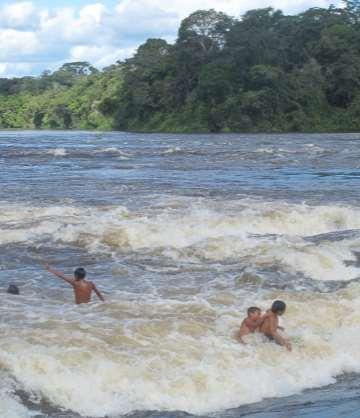

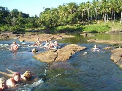

6 WHICH ECOSYSTEM SERVICES? Those related to local people s livelihoods OTHER, LIKE RECREATION


7 PROCESS: 1.P3DM 2.LAND USE-COVER MAP 3.P- ASSESSMENT OF ES 4.P- SCENARIO BUILDING 5.TRADEOFFS

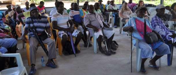
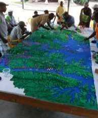
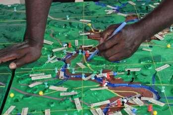
8 1.P3DM: Mobilization


9 1.P3DM: Making the legend 66 legend items were identified during workshops and subsequently re-grouped into 32 items which are represented in the P3DM.


10 1.P3DM: Making the blank model


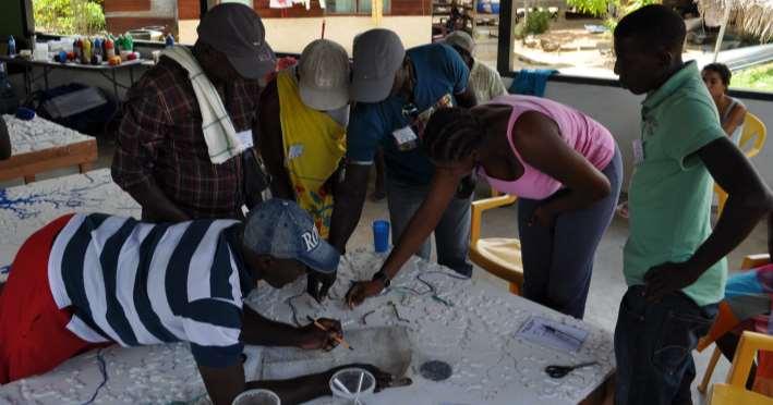

11 1.P3DM: Composing people s knowledge

12 1.P3DM: Composing people s knowledge


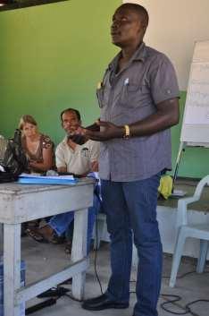
13 1.P3DM: Presentation to outsiders Show cased during the World Park Congress 2014 by a community representative


14 2. LAND USE-COVER MAP: Digitizing Sequential high resolution pictures are taken at 4 m distance and prepared for geo-referencing with GIS.

15 2. LAND USE-COVER MAP: Digitized map


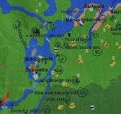
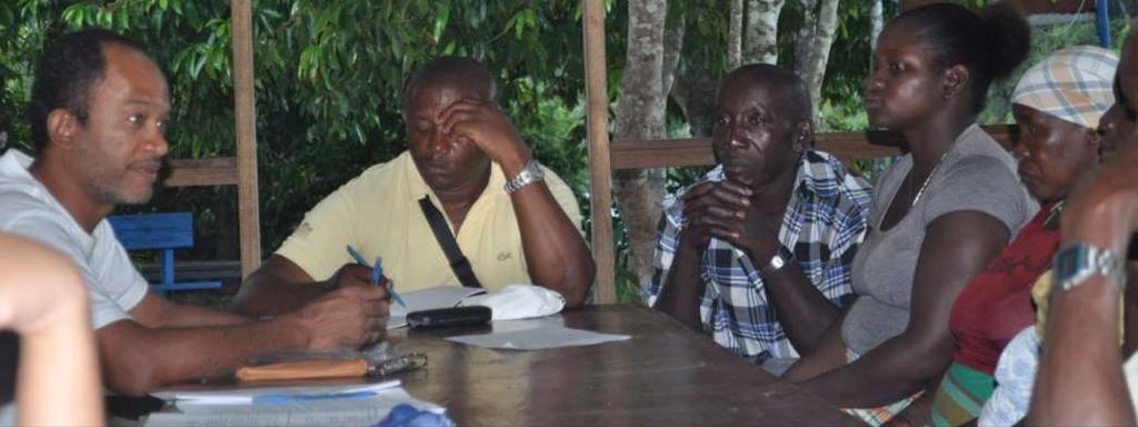
16 2. LAND USE-COVER MAP: Verification of the digitized information


17 2. LAND USE-COVER MAP: Handing the final map version. Printed maps in A0 size were handed to each of the 14 villages and primary schools of cluster 1. Additional maps in portable format will be handed in during next field trip.
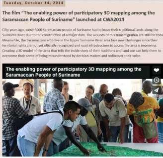
18 MAIN RESULTS P3DM PROCESSES An bird-eye view of the area, including villages and features that are not in official maps. The map is helpful as a planning and educational tool. A considerable amount of data was captured and stored in relatively short time (34 layers of information related to land use, land cover and important places depicted as areas, points and lines data). A geo-referenced and validated land cover map which can be combined with other georeferenced for use in further spatial analysis. The participation of 75 people in the preparation of the map legend and 47 in the actual participatory 3D mapping. The blank model was built with the collaboration of 25 kids. A 14 minutes film documenting the process and the context of the P3DM (
19 OUTCOMES P3DM PROCESSES Ownership of the process and the information. Collaborative research and capacity building: despite the literacy level of the local people, both researchers and local people are having equal understanding of the information being collaboratively produced. Likewise, collaboration in this research is creating capacity for local land use planning among local communities. Gain of trust with key local stakeholders within a relative short time. Transfer of knowledge to younger generations and information exchange between community participants.


20 3. P-ASSESSMENT OF ECOSYSTEM SERVICES (on going) Prioritizing ecosystem services Trend analysis of stocks of ecosystem services Ecosystem service governance


21 4. PARTICIPATORY SCENARIO BUILDING (in preparation) 1. Identification of current socioenvironmental conditions. 2. Which land use future we want?

22 5. TRADEOFFS (in preparation)

23 DANK U WEL VOOR UW AANDACHT Sunrise at the Caquetá River, Colombian Amazon. Sara Ramirez-Gomez
Mapping Maine s Working Waterfront: for Our Heritage and Economy
 Mapping Maine s Working Waterfront: for Our Heritage and Economy Abstract Mapping Maine s Working Waterfronts is a collaborative project led by the Island Institute that inventories the state s current
NSDI as a tool for Secure land tenure
 NSDI as a tool for Secure land tenure General Overview To look at the progress in SDI development and its application in policy formulation and impact on land tenure. INTEGRATION OF INFORMATION POLICIES
GOVERNMENT MAPPING WORKSHOP RECOVER Edmonton s Urban Wellness Plan Mapping Workshop December 4, 2017
 GOVERNMENT MAPPING WORKSHOP 12.4.17 RECOVER Edmonton s Urban Wellness Plan Mapping Workshop December 4, 2017 In July of 2017, City Council directed administration to develop RECOVER, Edmonton s Urban Wellness
ESTIMATING THE SOCIAL & ENVIRONMENTAL EFFECTS OF ADVENTURE TOURISM AND RECREATION ON CROWN LAND IN BRITISH COLUMBIA
 ESTIMATING THE SOCIAL & ENVIRONMENTAL EFFECTS OF ADVENTURE TOURISM AND RECREATION ON CROWN LAND IN BRITISH COLUMBIA Wolfgang Haider School of Resource and Environmental Mgt. Simon Fraser University Burnaby,
Demonstration Test Catchments building our capacity for catchment management
 Demonstration Test Catchments building our capacity for catchment management Bob Harris A joint project of Defra, WAG and the Environment Agency The BIG Challenges http://www.defra.gov.uk/evidence/science/how/strategy.htm
Integrated valuation of biodiversity and ecosystem services
 Integrated valuation of biodiversity and ecosystem services The challenge of articulating social, ecological and economic values in ecosystem services science and policy Integrated valuation What, Why
Community participation in sustainable tourism - A case study of two indigenous communities
 Po-Hsin Lai Department of Park, Recreation, and Tourism Sciences Texas A&M University Community participation in sustainable tourism - A case study of two indigenous communities Community participation
Community Engagement in Cultural Routes SiTI Higher Institute on Territorial Systems for Innovation Sara Levi Sacerdotti
 Transnational Workshop Wroclaw, 7th-8th December 2016 Community Engagement in Cultural Routes SiTI Higher Institute on Territorial Systems for Innovation Sara Levi Sacerdotti levi@siti.polito.it TAKING
Public Participatory GIS (ppgis), training & webgis in Mare Nostrum. Anna Spiteri, IRMCo Haifa, Israel, 5th March 2013
, training & webgis in Mare Nostrum. Anna Spiteri, IRMCo Haifa, Israel, 5th March 2013") Public Participatory GIS (ppgis), training & webgis in Mare Nostrum Anna Spiteri, IRMCo Haifa, Israel, 5th March 2013 What is ppgis? Why do we need it? Who participates? Where do we do it? When do we do
Public Participatory GIS (ppgis), training & webgis in Mare Nostrum Anna Spiteri, IRMCo Haifa, Israel, 5th March 2013 What is ppgis? Why do we need it? Who participates? Where do we do it? When do we do
Mapping ecosystem services provided by benthic habitats in the European Atlantic Ocean
 Mapping and Assessment Ecosystem Services and Links to Good Environmental Status Mapping ecosystem services provided by benthic habitats in the European Atlantic Ocean Ibon Galparsoro, Angel Borja and
INTEROPERABILITY AND SPATIAL PLANNING
 INSPIRE Conference 2011 Edimburgh, July 1st, 2011 INTEROPERABILITY AND SPATIAL PLANNING Franco Vico AMFM GIS Italia Flavio Camerata - DipSU, Università Roma Tre European Network of Best Practices for Interoperability
Module - 3 GIS MAPPING, MIS AND GIS UNDER RAY
 Module - 3 1 GIS MAPPING, MIS AND GIS MIS INTEGRATION UNDER RAY Role of GIS & MIS under RAY Under the scheme, two step implementation strategy has been adopted i.e. preparation of SFCPoAs on whole city
Prepared by: Precious Annie Lopez & Nolwenn Boucher
 Recognizing the ancestral land and biodiversity conservation efforts of indigenous people in Quinchao municipality using GIS- and participatory 3Dmapping tool Prepared by: Precious Annie Lopez & Nolwenn
Sample assessment task. Task details. Content description. Year level 7
 Sample assessment task Year level 7 Learning area Subject Title of task Task details Description of task Type of assessment Purpose of assessment Assessment strategy Evidence to be collected Suggested
Local EPM Implementation Process in 5 stages
 Local PM Implementation Process in 5 stages 3. Working groups 1. City nvironmental Profile/ Outlook 5. Consolidation & Institutionalisation 4. Strategy & Action plans 2. City Consultation Urban nvironmental
GIS Workshop Data Collection Techniques
 GIS Workshop Data Collection Techniques NOFNEC Conference 2016 Presented by: Matawa First Nations Management Jennifer Duncan and Charlene Wagenaar, Geomatics Technicians, Four Rivers Department QA #: FRG
Overview of Methods. Terrestrial areas that are most important for conservation Conservation
 Overview of Methods The goal of the Western Lake Erie Coastal Conservation Vision project (WLECCV) is to define where we should be working locally to optimally achieve regional conservation impact. The
Assessment and valuation of Ecosystem Services for decision-makers
 Assessment and valuation of Ecosystem Services for decision-makers An introduction to the ARIES approach Ferdinando Villa *, Ken Bagstad Gary Johnson, Marta Ceroni *Basque Center for Climate Change, Bilbao,
Fig 1. Steps in the EcoValue Project
 Assessing the Social and Economic Value of Ecosystem Services in the Northern Forest Region: A Geographic Information System (GIS) Approach to Landscape Valuation Principal Investigator(s): Dr. Matthew
Urban Climate Resilience
 Urban Climate Resilience in Southeast Asia Partnership Project Introduction Planning for climate change is a daunting challenge for governments in the Mekong Region. Limited capacity at the municipal level,
TP4D. Fostering territorial perspective for development. Towards a wider alliance
 Fostering territorial perspective for development Towards a wider alliance FOR several years, territorial approaches to development have been spreading within international organizations and among development
COMMON CONCEPTUAL AND OPERATIONAL FRAMEWORKS FOR RESEARCH AND SUSTAINABLE MANAGEMENT OF NESTED SOCIO-ECOLOGICAL SYSTEMS ACROSS LARGE WATERSHEDS
 COMMON CONCEPTUAL AND OPERATIONAL FRAMEWORKS FOR RESEARCH AND SUSTAINABLE MANAGEMENT OF NESTED SOCIO-ECOLOGICAL SYSTEMS ACROSS LARGE WATERSHEDS Angheluta VADINEANU 1 & Nusret KARAKAYA 2 1 Department of
What is Spatial Planning?
 Spatial Planning in the context of the Responsible Governance of Tenure What is Spatial Planning? Text-only version This course is funded by the European Union through the EU-FAO Improved Global Governance
Environmental Management Information System (EMIS)
") United Nations Human Settlements Programme (UN-HABITAT) United Nations Environment Programme (UNEP) Environmental Management Information System (EMIS) a tool for Environmental Planning and Management (EPM)
United Nations Human Settlements Programme (UN-HABITAT) United Nations Environment Programme (UNEP) Environmental Management Information System (EMIS) a tool for Environmental Planning and Management (EPM)
Possibilities for applying ES assessment results in spatial planning in Latvia
 Possibilities for applying ES assessment results in spatial planning in Latvia Inga Hoņavko LIFE EcosystemServices project manager LIFE Viva Grass seminar, Sigulda, 17.05.2018 Projekts LIFE EcosystemServices,
Empowered lives. Resilient nations. Data for People and Planet. powered by
 Empowered lives. Resilient nations. Data for People and Planet powered by Overview As we enter the fourth industrial revolution, technology is revolutionizing our ability to map nature. Satellite data
Statement of Mr. Sandagdorj Erdenebileg, Chief, Policy Development, Coordination, Monitoring and Reporting Service, UN-OHRLLS.
 Statement of Mr. Sandagdorj Erdenebileg, Chief, Policy Development, Coordination, Monitoring and Reporting Service, UN-OHRLLS at the Botswana National Workshop on the Vienna Programme of Action 27 th October
The Underutilization of GIS & How to Cure It. Adam Carnow Esri
 The Underutilization of GIS & How to Cure It Adam Carnow Esri What is GIS? A framework to organize, communicate, and understand the science of our world Business Intelligence (BI) is the set of
Measurement of the Urban-Housing Deficit:
 Measurement of the Urban-Housing Deficit: Strategies, tools and sources of information The International Network for Urban and Regional Statistics Standing Committee of the International Association for
Towards Reliable Spatial Database of Informal Areas in Greater Cairo Region
 KEYWORDS informal areas, unreliable spatial data, spatial data collecting, capacity building SUMMARY The uncontrolled and rapid increase of Egypt s cities is a major problem of the country. More than the
Rationale for measuring and monitoring forestrelated indicators for the "Caminos de Liderazgo
 Photo: Daniel Villafranca Rationale for measuring and monitoring forestrelated indicators for the "Caminos de Liderazgo Program", Osa Region, Costa Rica Lucia Morales Barquero April 2014 This document
Environmental & Socio-economic impacts of mass rapid transit using GIS
 Environmental & Socio-economic impacts of mass rapid transit using GIS BITS Pilani Pilani Campus Dr. Rajiv Gupta, Senior Professor, Department of Civil Engineering, Birla Institute of Technology and Science
ROLE OF SPATIAL PLANNING TOOLS AT MESO-SCALE IN THE MANAGEMENT OF NATURAL RESOURCES, LESSONS LEARNT FROM AFRICAN COUNTRIES
 6th Nov, 2012 ROLE OF SPATIAL PLANNING TOOLS AT MESO-SCALE IN THE MANAGEMENT OF NATURAL RESOURCES, LESSONS LEARNT FROM AFRICAN COUNTRIES Masoom Hamdard Environmental Planning and Assessment for Adaptation
GIS as a tool for rural livelihoods enhancement planning
 GIS as a tool for rural livelihoods enhancement planning (Case study of Alosylat region -Shareg Alnil-Sudan) Almojtaba M. H. Hassabo Federal Ministry of Agriculture Sudan A research submitted to the Development
Overview of Technical Advisory Missions
 Expert Group Meeting (EGM) on Georeferenced Information Systems for Disaster Risk Management (Geo-DRM) and sustaining the Community of Practice (COP) 23-25 April 2014 Bangkok Overview of Technical Advisory
A Method for Mapping Settlement Area Boundaries in the Greater Golden Horseshoe
 A Method for Mapping Settlement Area Boundaries in the Greater Golden Horseshoe Purpose This paper describes a method for mapping and measuring the lands designated for growth and urban expansion in the
RETA 6422: Mainstreaming Environment for Poverty Reduction Category 2 Subproject
 RETA 6422: Mainstreaming Environment for Poverty Reduction Category 2 Subproject A. Basic Data 1. Subproject Title: Poverty-Environment Mapping to Support Decision Making 2. Country Director: Adrian Ruthenberg
SPLAN-Natura Towards an integrated spatial planning approach for Natura th January, 2017 Brussels. Commissioned by DG Environment
 SPLAN-Natura 2000 Towards an integrated spatial planning approach for Natura 2000 Commissioned by DG Environment 17 th January, 2017 Brussels V. Simeonova (Ph.D.) Drivers towards integrating Biodiversity
Geospatial SDI Portal for effective Governance of Pune METROPOLIS region
 Geospatial SDI Portal for effective Governance of Pune METROPOLIS region Mr. Praveen Gautam Senior Manager 19 th January 2018 PMRDA Overview Provide a Spatial Framework for the entire region with various
Brian D. George. GIMS Specialist Ohio Coastal Atlas Project Coordinator and Cartographer. Impacts and Outcomes of Mature Coastal Web Atlases
 Ohio Coastal Atlas Project Brian D. George GIMS Specialist Ohio Coastal Atlas Project Coordinator and Cartographer Ohio Department of Natural Resources Office of Coastal Management Sandusky, OH Impacts
ACCESSIBILITY TO SERVICES IN REGIONS AND CITIES: MEASURES AND POLICIES NOTE FOR THE WPTI WORKSHOP, 18 JUNE 2013
 ACCESSIBILITY TO SERVICES IN REGIONS AND CITIES: MEASURES AND POLICIES NOTE FOR THE WPTI WORKSHOP, 18 JUNE 2013 1. Significant differences in the access to basic and advanced services, such as transport,
Visualization tools for coastal climate change vulnerability assessment and adaptation guidelines: a case study in Cartagena, Colombia
 Visualization tools for coastal climate change vulnerability assessment and adaptation guidelines: a case study in Cartagena, Colombia Vivian Ochoa, Paula Cristina Sierra-Correa, Venus Rocha, Francisco
Disaster Management & Recovery Framework: The Surveyors Response
 Disaster Management & Recovery Framework: The Surveyors Response Greg Scott Inter-Regional Advisor Global Geospatial Information Management United Nations Statistics Division Department of Economic and
Oman NSDI Business Values and Future Directions. Hassan Alawi Alghazali Acting Director General National Spatial Data Infrastructure
 Oman NSDI Business Values and Future Directions Hassan Alawi Alghazali Acting Director General National Spatial Data Infrastructure Presentation Outline Geospatial Maturity Current Challenges NCSI s Role
Planning Group for Kecamatan Bukit Batu gathered at Kalimantan Visioning Workshop March 2008 by Viktor Boehm, Nick Mawdsley and Daniela Bustillo
 Planning Group for Kecamatan Bukit Batu gathered at Kalimantan Visioning Workshop 15-17 March 2008 by Viktor Boehm, Nick Mawdsley and Daniela Bustillo Connecting Government and Community through Innovative
SPATIAL AND TEMPORAL MODELLING OF ECOSYSTEM SERVICES
 SPATIAL AND TEMPORAL MODELLING OF ECOSYSTEM SERVICES Solen Le Clec h, T.Decaëns, S. Dufour, M. Grimaldi, N. Jégou and J. Oszwald ACES Conference 2016 Jacksonville, Florida (USA). December, 5-9th : issues
Aboriginal communities strengthen governance with location-based tools in the 21st century
 Aboriginal communities strengthen governance with location-based tools in the 21st century Today, Aboriginal communities are taking advantage of the geomatics technologies that underpin popular online
International Guidelines on Access to Basic Services for All
 International Guidelines on Access to Basic Services for All Presentation and initials lessons from implementation Accessibility to services in regions and cities : measures and policies, OECD 18 June
Declaration Population and culture
 Declaration Population and culture The ministers of the parties to the Alpine Convention regard the socio-economic and socio-cultural aspects mentioned in Article 2, Paragraph 2, Item a., as being central
Analysis of Rural-Urban Systems and Historic Climate Data in Mexico
 Analysis of Rural-Urban Systems and Historic Climate Data in Mexico Global Conference on Big Data for Official Statistics October 2015, Abu Dhabi, UAE RURAL-URBAN SYSTEMS Rural-Urban Systems: Functional
Proposed Scope of Work Village of Farmingdale Downtown Farmingdale BOA Step 2 BOA Nomination Study / Draft Generic Environmental Impact Statement
 Proposed Scope of Work Village of Farmingdale Downtown Farmingdale BOA Step 2 BOA Nomination Study / Draft Generic Environmental Impact Statement The scope of work that follows incorporates and covers
INSPIRE Basics. Vlado Cetl European Commission Joint Research Centre. https://ec.europa.eu/jrc/
 INSPIRE Basics Vlado Cetl European Commission Joint Research Centre https://ec.europa.eu/jrc/ Serving society Stimulating innovation Supporting legislation Outline SDI? Why European SDI? INSPIRE Policy
National Land Use Policy and National Integrated Planning Framework for Land Resource Development
 Title National Land Use Policy and National Integrated Planning Framework for Land Resource Development Duration: 32 Weeks Objective: Adoption of appropriate land use planning approaches to: Maintain the
Together towards a Sustainable Urban Agenda
 Together towards a Sustainable Urban Agenda The City We (Youth) Want Preliminary findings from youth consultations Areas Issue Papers Policy Units 1.Social Cohesion and Equity - Livable Cities 2.Urban
Targeting the Poor. Towards evidence-based implementation. Johan A. Mistiaen (World Bank)
") Targeting the Poor Towards evidence-based implementation Johan A. Mistiaen (World Bank) Presentation at Joint Poverty Assessment Workshop Nairobi - May 19, 2005 Outline Integrating Data Sources - GIS What
Targeting the Poor Towards evidence-based implementation Johan A. Mistiaen (World Bank) Presentation at Joint Poverty Assessment Workshop Nairobi - May 19, 2005 Outline Integrating Data Sources - GIS What
WAPICHAN TERRITORIAL GOVERNANCE MODEL. South Central and South Rupununi Districts Toshaos Councils, Region 9, GUYANA
 WAPICHAN TERRITORIAL GOVERNANCE MODEL South Central and South Rupununi Districts Toshaos Councils, Region 9, GUYANA Chief Kokoi, COP13 Cancún, 11 December 2016 CONTENTS OF OUR TERRITORIAL GOVERNANCE PLAN:
Nebraska Core Academic Content Standards Science Grade: 2 - Adopted: 2010
 Main Criteria: Nebraska Core Academic Content Standards Secondary Criteria: Subjects: Science, Social Studies Grade: 2 Correlation Options: Show Correlated Nebraska Core Academic Content Standards Science
Seagrass research & ecosystem services
 PROTECTING DUGONGS CONSERVING SEAGRASS CHANGE FOR COMMUNITIES Seagrass research & ecosystem services INCEPTION WORKSHOP THE GEF DUGONG AND SEAGRASS CONSERVATION PROJECT 20-21 October 2015 Colombo, Sri
The Added Value of Geospatial Data in a Statistical Office. Pedro Diaz Munoz Director Sectoral and Regional Statistics EUROSTAT European Commission
 The Added Value of Geospatial Data in a Statistical Office Pedro Diaz Munoz Director Sectoral and Regional Statistics EUROSTAT European Commission Why integrate Responsibility of all the information we
Understanding China Census Data with GIS By Shuming Bao and Susan Haynie China Data Center, University of Michigan
 Understanding China Census Data with GIS By Shuming Bao and Susan Haynie China Data Center, University of Michigan The Census data for China provides comprehensive demographic and business information
Combining Three Modelling and Visualization Tools for Collaborative Planning of Urban Transformation
 152 Combining Three Modelling and Visualization Tools for Collaborative Planning of Urban Transformation Ulrike WISSEN HAYEK 1, Noemi NEUENSCHWANDER 1, Timo VON WIRTH 2, Antje KUNZE 3, Jan HALATSCH 3,
Sustainable and Harmonised Development for Smart Cities The Role of Geospatial Reference Data. Peter Creuzer
 Sustainable and Harmonised Development for Smart Cities The Role of Geospatial Reference Data Peter Creuzer 1. Introduction - Smart Cities and Geodata 2. Geodata in Germany 3. Examples 4. Data and Service
Belfairs Academy GEOGRAPHY Fundamentals Map
 YEAR 12 Fundamentals Unit 1 Contemporary Urban Places Urbanisation Urbanisation and its importance in human affairs. Global patterns of urbanisation since 1945. Urbanisation, suburbanisation, counter-urbanisation,
Sistema de Informacion Geografica Peninsular de Yucatan (SIGPY): WORK PLAN for the UQROO- URI GIS Development Project
: WORK PLAN for the UQROO- URI GIS Development Project") Sistema de Informacion Geografica Peninsular de Yucatan (SIGPY): WORK PLAN for the UQROO- URI GIS Development Project Eddie Ellis, UQROO 2001 Citation: Quintana Roo, Mexico: Universidad de Quintana Roo
Sistema de Informacion Geografica Peninsular de Yucatan (SIGPY): WORK PLAN for the UQROO- URI GIS Development Project Eddie Ellis, UQROO 2001 Citation: Quintana Roo, Mexico: Universidad de Quintana Roo
Egypt Public DSS. the right of access to information. Mohamed Ramadan, Ph.D. [R&D Advisor to the president of CAPMAS]
![Egypt Public DSS. the right of access to information. Mohamed Ramadan, Ph.D. [R&D Advisor to the president of CAPMAS]](/thumbs/89/98483713.jpg "Egypt Public DSS. the right of access to information. Mohamed Ramadan, Ph.D. [R&D Advisor to the president of CAPMAS]") Egypt Public DSS ì the right of access to information Central Agency for Public Mobilization and Statistics Arab Republic of Egypt Mohamed Ramadan, Ph.D. [R&D Advisor to the president of CAPMAS] Egypt
Egypt Public DSS ì the right of access to information Central Agency for Public Mobilization and Statistics Arab Republic of Egypt Mohamed Ramadan, Ph.D. [R&D Advisor to the president of CAPMAS] Egypt
Economic and Social Council
 United Nation E/C.20/2012/4/Add.1 Economic and Social Council Distr.: General 2 July 2012 Original: English Committee of Experts on Global Geospatial Information Management Second session New York, 13-15
Mapping and Assessment of Ecosystems and their Services
 Mapping and Assessment of Ecosystems and their Services ALTER-Net Conference 2013: Science underpinning the EU 2020 Biodiversity Strategy. April 2013 Gent Joachim MAES 1 This presentation is based on the
Land Use in the context of sustainable, smart and inclusive growth
 Land Use in the context of sustainable, smart and inclusive growth François Salgé Ministry of sustainable development France facilitator EUROGI vice president AFIGéO board member 1 Introduction e-content+
NREL, Intro to GIS for Wind Energy Siting for IGERT Wind NSF
 NREL, 2010 Intro to GIS for Wind Energy Siting for IGERT Wind NSF Challenge: How to encourage offshore wind in the US while managing ecological responsibility and ocean use conflicts? Introduction NREL,
Terms of Reference for the Comparative Environmental Review (CER) of. Options for the Mactaquac Project, Mactaquac, New Brunswick
 of. Options for the Mactaquac Project, Mactaquac, New Brunswick") Terms of Reference for the Comparative Environmental Review (CER) of Options for the Mactaquac Project, Mactaquac, New Brunswick Preamble The New Brunswick Power Corporation ( NB Power ) operates the Mactaquac
Terms of Reference for the Comparative Environmental Review (CER) of Options for the Mactaquac Project, Mactaquac, New Brunswick Preamble The New Brunswick Power Corporation ( NB Power ) operates the Mactaquac
Community Participation in Land Governance Through Citywide Community Mapping GLTN Learning Exchange, Bayview Hotel, Manila November 7, 2017
 Community Participation in Land Governance Through Citywide Community Mapping GLTN Learning Exchange, Bayview Hotel, Manila November 7, 2017 Community-Led, Citywide Settlement Profiling and Mapping as
Creating a framework for mapping opportunity space to enhance ecological resilience in Wales
 Creating a framework for mapping opportunity space to enhance ecological resilience in Wales Dr Katie Medcalf CEnv MCIEEM MBSSS Why place matters To get a resilient Wales we need to maximise the benefit
City and SUMP of Ravenna
 City and SUMP of Ravenna Nicola Scanferla Head of Mobility Planning Unit, Municipality of Ravenna nscanferla@comune.ra.it place your logo here 19 April, 2017 1st Steering Committee Meeting, Nicosia, Cyprus
Spatial Analysis Unit
 SESA Social i a and Economicc Spatial Analysis Unit A Genuine Approach to Using Geographic Information for More Effective Government Recipient of: 2005 Newfoundland and Labrador Public Service Award of
GIS in Community & Regional Planning
 GIS in Community & Regional Planning The The role role of of GIS GIS in in Re-writing the the Zoning Bylaw for for the the City City of of Vernon LandInfo Technologies Presentation Overview The GIS Initiative
Update ecosystem services analysis in SEEA Experimental Ecosystem Accounting
 Update ecosystem services analysis in SEEA Experimental Ecosystem Accounting Prof. Dr Lars Hein, Wageningen University With materials produced by or in collaboration with CBS, Statistics the Netherlands
Implementation Status & Results Indonesia Improving Governance for Sustainable Indigenous Community Livelihoods in Forested Areas (P130632)
") Public Disclosure Authorized Public Disclosure Authorized The World Bank Implementation Status & Results Indonesia Improving Governance for Sustainable Indigenous Community Livelihoods in Forested Areas
Public Disclosure Authorized Public Disclosure Authorized The World Bank Implementation Status & Results Indonesia Improving Governance for Sustainable Indigenous Community Livelihoods in Forested Areas
3/29/11. Why bother with tools? Incorporating Decision Support Tools into Climate Adaptation Planning. A Simplified Planning Process
 Incorporating Decision Support Tools into Climate Adaptation Planning Why bother with tools? Tools don t eliminate complexity but they can help deal with it" Tools can:"! Help incorporate science into
Rhode Island World-Class Standards Science Grade: K - Adopted: 2006
 Main Criteria: Rhode Island World-Class Standards Secondary Criteria: Subjects: Science, Social Studies Grade: K Correlation Options: Show Correlated Rhode Island World-Class Standards Science Grade: K
Framework on reducing diffuse pollution from agriculture perspectives from catchment managers
 Framework on reducing diffuse pollution from agriculture perspectives from catchment managers Photo: River Eden catchment, Sim Reaney, Durham University Introduction This framework has arisen from a series
Introduction and Project Overview
 Greater New Orleans Regional Land Use Modeling GIS Techniques in a P olitical C ontext Louisiana Remote Sensing and GIS Workshop Wednesday, April 24, 2013 Working Towards a Shared Regional Vision Introduction
GLP Workshop on. The design of integrative models of natural and social systems in land change science
 The Global land Project Nodal Office on Integration and Modelling, Aberdeen, UK GLP Workshop on The design of integrative models of natural and social systems in land change science Introduction Post Workshop
The Integrated Ge spatial Information Framework to the strengthening of NSDI, Mongolia
 Young Geospatial Professionals Summit 21 NOV 2018 The Integrated Ge spatial Information Framework to the strengthening of NSDI, Mongolia BAYARMAA ENKHTUR Geospatial information and technology department
GIS and Community Health. GIS and Community Health. Institutional Context and Interests in GIS Development. GIS and Community Health
 GIS and Community Health GIS and Community Health Some critiques of GIS emphasize the potentially harmful social consequences of the diffusion of GIS technology, including reinforcing the power of state
Applying Health Outcome Data to Improve Health Equity
 Applying Health Outcome Data to Improve Health Equity Devon Williford, MPH, Health GIS Specialist Lorraine Dixon-Jones, Policy Analyst CDPHE Health Equity and Environmental Justice Collaborative Mile High
UNION DES COMORES. Unité - solidarité - développement
 UNION DES COMORES Unité - solidarité - développement ---------------------- VICE-PRESIDENCE EN CHARGE DU MINISTERE DE L AGRICULTURE, DE LA PECHE, DE L ENVIRONNEMENT, DE L AMENAGEMENT DU TERRITOIRE ET DE
The Thresholds working Group.
 A Report for the CEESP on the Key Biodiversity Areas (KBA) Delineation Workshop organized by the IUCN during 10-15 March 2013, Front Royal, Virginia, USA. The joint task force of the World Commission of
Developing a Community Geographical Information System (GIS) in Rural India
 in Rural India") Developing a Community Geographical Information System (GIS) in Rural India Before rushing off and describing the unique challenges of developing a small scale GIS system India I better first describe
Developing a Community Geographical Information System (GIS) in Rural India Before rushing off and describing the unique challenges of developing a small scale GIS system India I better first describe
Your web browser (Safari 7) is out of date. For more security, comfort and the best experience on this site: Update your browser Ignore
 is out of date. For more security, comfort and the best experience on this site: Update your browser Ignore") Your web browser (Safari 7) is out of date. For more security, comfort and the best experience on this site: Update your browser Ignore U NLO CKING THE EDUCATIO NAL PO TENTIAL O F CITIZEN SCIENCE Essays
Your web browser (Safari 7) is out of date. For more security, comfort and the best experience on this site: Update your browser Ignore U NLO CKING THE EDUCATIO NAL PO TENTIAL O F CITIZEN SCIENCE Essays
Geospatial Technologies for Resources Planning & Management
 Geospatial Technologies for Resources Planning & Management Lal Samarakoon, PhD Director, Geoinformatics Center Asian Institute of Technology, Thailand Content Geoinformatics for SDG Information Integration
RURAL-URBAN PARTNERSHIPS: AN INTEGRATED APPROACH TO ECONOMIC DEVELOPMENT
 RURAL-URBAN PARTNERSHIPS: AN INTEGRATED APPROACH TO ECONOMIC DEVELOPMENT William Tompson Head of the Urban Development Programme OECD Public Governance and Territorial Development Directorate JAHRESTAGUNG
Martin MENSA, Eli SABLAH, Emmanuel AMAMOO-OTCHERE and Foster MENSAH, Ghana. Key words: Feeder Roads Condition Survey, Database Development
 Digital Mapping and GIS-Driven Feeder Road Network Database Management System for Road Project Planning and Implementation Monitoring in the Feeder Road Sector Martin MENSA, Eli SABLAH, Emmanuel AMAMOO-OTCHERE
Spatial Data Management of Bio Regional Assessments Phase 1 for Coal Seam Gas Challenges and Opportunities
 Spatial Data Management of Bio Regional Assessments Phase 1 for Coal Seam Gas Challenges and Opportunities By Dr Zaffar Sadiq Mohamed-Ghouse Principal Consultant, Spatial & IT, GHD zaffar.sadiq@ghd.com
Contribution of public transport to urban accessibility in the Netherlands
 Contribution of public transport to urban accessibility in the Netherlands Ambrosius Baanders ECORYS, Rotterdam Paul van Beek & Sander van der Eijk Goudappel Coffeng, Deventer increasing congestion decreasing
ANGOLA: PARTICIPATORY MAPPING OF URBAN POVERTY. By Allan Cain, Development Workshop
 ANGOLA: PARTICIPATORY MAPPING OF URBAN POVERTY By Allan Cain, Development Workshop Angola: Participatory Mapping of Urban Poverty BY ALLAN CAIN, DEVELOPMENT WORKSHOP This paper explains a method for measuring
Pequabuck River Flooding Study and Flood Mitigation Plan The City of Bristol and Towns of Plainville and Plymouth, CT
 Pequabuck River Flooding Study and Flood Mitigation Plan The City of Bristol and Towns of Plainville and Plymouth, CT Raymond Rogozinski and Maged Aboelata The City of Bristol and Towns of Plainville and
Ministry of ICT of I.R.IRAN
 The ECO 8/6 mill km 2 10 Slamic countries ~330 mill people Oil, Gas, Industries,Tourism 2 Issue transformation in last decade Problem solving needs more integrated approach More interaction &complexity
Designing Networks of Marine Protected Areas in DFO s Three Atlantic Bioregions
 Designing Networks of Marine Protected Areas in DFO s Three Atlantic Bioregions Presentation for Indigenous Protected Areas Workshop Max Westhead, DFO and Adrian Gerhartz-Abraham, Dalhousie March 29, 2017
Environmental Response Management Application
 Environmental Response Management Application Coastal Response Research Center Nancy Kinner, Michele Jacobi, Rob Braswell, Kurt Schwehr & Amy Merten RRT III May 14, 2008 1 Talk Outline Overview of Center
UNITED NATIONS ECONOMIC COMMISSION FOR EUROPE. Road Maps for Mainstreaming Ageing
 UNITED NATIONS ECONOMIC COMMISSION FOR EUROPE Population Unit www.unece.org/pau Road Maps for Mainstreaming Ageing Fiona Willis Núñez fiona.willis nunez@unece.org Sub-Regional Capacity Development Workshop