A classification of the vegetation of the western Transvaal dolomite and chert grassland, South Africa
|
|
|
- Lily Copeland
- 6 years ago
- Views:
Transcription

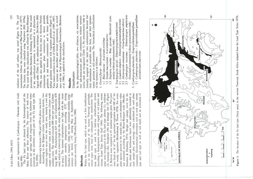
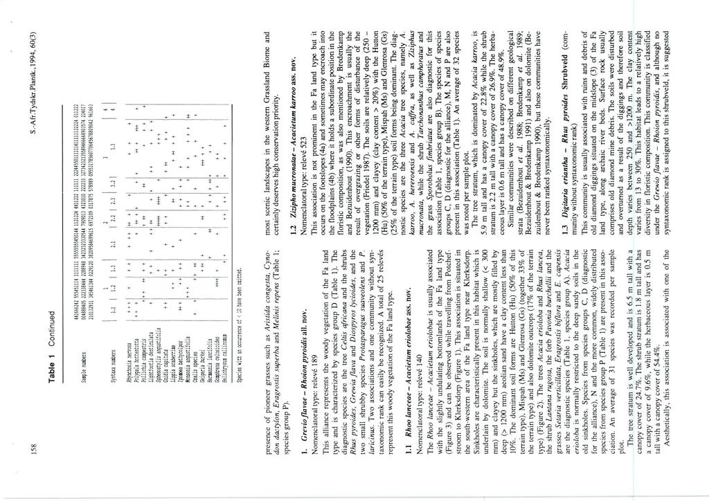
1 152 S.Afr.J.Bot., 1994, 60(3): A classification of the vegetation of the western Transvaal dolomite and chert grassland, South Africa H. Bezuidenhout,* G.J. Bredenkamp and G.K. Theron Department of Botany, University of Pretoria, Pretoria 0002, Republic of South Africa Received 21 October 1993; revised I March 1994 Relatively litde is known about the vegetation of the western Grassland Biome in South Africa. The classification of the dolomite and chert grassland in the western Transvaal (Fa land type) forms part of a research programme on the syntaxonomic and synecological synthesis of the vegetation of the western Grassland Biome. Using a numerical classification technique (TWINSPAN) as a first approximation, the classification was refined by applying Braun-Blanquet procedures. The result is a phytosociological table from which two new alliances, six new associations, two new sub-associations and two new communities without syntaxonomic rank are recognized. The new syntaxa are ecologically interpreted as well as described. Associated gradients in habitat were identified by using an ordination algorithm (DECORANA). This study should contribute to the present knowledge and ecological understanding of the vegetation of the western Transvaal. Relatief min inligting is oor die plantegroei van die westelike Grasveldbioom van Suid-Afrika beskikbaar. Die klassifikasie van die plantegroei van die dolomitiese en chert-grasveld in die Wes-Transvaal (Fa-landtipe) vorm deel van die sintaksonomiese en sinekologiese sintese van die plantegroei van die westelike Grasveldbioom. 'n Numeriese tegniek (TWINSPAN) is as eerste klassifikasie van die floristiese data aangewend. Daarna is die Braun-Blanquetprosedure gevolg om twee nuwe alliansies, ses nuwe assosiasies, twee nuwe subassosiasies en twee nuwe gemeenskappe sender range in 'n fitososiologiese tabel te identifiseer. Die nuwe sintaksons word ekologies gernterpreteer en beskryt. Geassosieerde gradiente in habitat is deur toepassing van 'n ordeningsalgoritme (DECORANA) ge'identifiseer. Hierdie studie behoort 'n waardevolle bydrae tot die ekologiese kennis oor die plantegroei van die Wes-Transvaal te lewer. Keywords: Braun-Blanquet, Fa land type, Grassland Biome, vegetation classification. To whom correspondence should be addressed at: National Parks Board, Scientific Services, P.O. Box , Hadison Park, Kimberley 8306, Republic of South Africa. Introduction Mentis and Huntley (1982) as well as Scheepers (1986) stated the necessity to detennine the location and extent of the major vegetation types and subtypes within the Grassland Biome. As part of a phytosociological research programme on the syntaxonomic synthesis of the vegetation of the Grassland Biome in South Africa, several studies have been carried out (Bezuidenhout 1988; Turner 1989; Kooij 1990; Myburgh 1990; Breytenbach 1991; du Prcez 1991; Eckhardt 1993). A mosaic of land types occur in the study area (Figure 1 ). As land types represent an ecologically based stratification of the study area, each land type is separately used to describe the vegetation of the western Transvaal grassland (Bezuidenhout, in prep.). In this paper, a description of the vegetation of the Fa land type in the study area is presented. A broad, regional account of the vegetation of the Fa land type and a number of other land types was given by Acocks (1953, 1988). Vegetation studies have been conducted in the Potchefstroom area (Louw 1951), Lichtcnburg area (Morris 1973), Abe Bailey Nature Reserve (Yan Wyk 1983) and the Mooi River catchment area (Bezuidenhout 1988). A part of the dolomite or Klipveld vegetation was described by Bezuidenhout and Bredcnkamp (1990). In the Jack Scott Nature Reserve, which is situated adjacent to the north-eastern boundary of the study area, the dolomite vegetation was investigated by Coetzee (1974) and Scogings and Theron (1990). Proper land use requires a classification of the vegetation Some of the data for this research were collected by H.B. while employed by the Department of Agricultural Development, Grassland Research Centre. Private Bag X05, Lynn East, 0039 Republic of South Africa. (Yan Rooycn et al. 1981), in order to identify conservation priorities. This is a comprehensive vegetation classification of the dolomite and chert area which includes the entire Fa land type in the western Transvaal. This report forms part of the synthesis of the vegetation of the western Grassland Biome of South Africa and the results should contribute significantly to the ultimate aim of a phytosociological and syntaxonomical synthesis of the western Grassland Biome. Study area The study area is situated in the western part of the Highveld Agricultural Region in the Transvaal and is bounded by latitudes 25 45' and 27 15' south and longitudes 24 45' and 28 00' east (Figure 1). The Fa land type covers approximately ha of land, and the Land Type Survey Staff (1984) estimated that 35% is unavailable for agronomy. The main rock types which underly the Fa land type are dolomite and chert of the Chuniespoort Group (Transvaal Sequence). The slightly undulating plains are dissected by prominent rocky chert ridges (Land Type Survey Staff 1984). More than 50% of the main soil types are relatively shallow (between 50 and 150 mm) and rocky (dolomite and chert) with the dominant soil forms Mispah, Glenrosa and shallow Hutton (Land Type Survey Staff 1984). The vegetation is distributed in a complex mosaic pauem, and is not dominated by a single or a few species. It rather represents a mosaic of many co-dominants (Louw 1951 ). According to the Acocks (1988) classification, the largest pan of the Fa land type vegetation is represented by the western variations of the Bankenveld (veld type 61a) while the remaining
2
3
4
5
6
7
8
9
10
11
A reconnaissance survey of the vegetation of the plains in the Potchefstroom F ochville-parys area
 S.Afr.J. Bot., 1989,55(2): 199-206 199 A reconnaissance survey of the vegetation of the plains in the Potchefstroom F ochville-parys area G.J. Bredenkamp*, A.F. Joubert and H. Bezuidenhout Department of
CHAPTER 3 METHODS Introduction
 CHAPTER 3 METHODS Introduction Ecological studies of entire ecosystems often have a descriptive nature due to the difficulties of setting up true experimental controls within these complex and multivariate
The vegetation of the north-western Orange Free State, South Africa. 1. Physical environment
 Bothalia 20,2: 2 3 3-2 4 0 (1990) The vegetation of the north-western Orange Free State, South Africa. 1. Physical environment M.S. KOOIJ* G.J. BREDENKAMP* and G.K. THERON* Keywords: climate, geology,
SOIL INFORMATION FOR PUMPED WATER STORAGE SCHEME, STEELPOORT VALLEY
 REPORT On contract research for Bohlweki Environmental SOIL INFORMATION FOR PUMPED WATER STORAGE SCHEME, STEELPOORT VALLEY February 2007 By D.G. Paterson ARC-Institute for Soil, Climate and Water, Private
Classification of Plant Communities
 1 Module # 12 Component # 2 Objective Understand the function that plant communities and vegetation units have in drawing up a wildlife management plan, and to understand the methods associated with the
THE EFFECT OF HABITAT CHANGE ON THE STRUCTURE OF DUNG BEETLE ASSEMBLAGES IN THE NORTH-EASTERN FREE STATE: A COMPARISON OF CONSERVED AND FARMED LAND
 THE EFFECT OF HABITAT CHANGE ON THE STRUCTURE OF DUNG BEETLE ASSEMBLAGES IN THE NORTH-EASTERN FREE STATE: A COMPARISON OF CONSERVED AND FARMED LAND by Astrid Jankielsohn Submitted in partial fulfilment
THE PHYTOSOCIOLOGY OF THE NATURAL VEGETATION OCCURING IN THE CRADLE OF HUMANKIND WORLD HERITAGE SITE, GAUTENG. SOUTH AFRICA
 THE PHYTOSOCIOLOGY OF THE NATURAL VEGETATION OCCURING IN THE CRADLE OF HUMANKIND WORLD HERITAGE SITE, GAUTENG. SOUTH AFRICA by GARETH ELOFF Submitted in accordance with the requirements for the degree
Bronkhorstspruit, South Africa
 The vegetation ecology of Ezemvelo Nature Reserve, Bronkhorstspruit, South Africa By Barbara Anna Swanepoel Submitted in partial fulfilment of the requirements for the degree Magister Scientia in the Faculty
Government Gazette Staatskoerant
 Government Gazette Staatskoerant REPUBLIC OF SOUTH AFRICA REPUBLIEK VAN SUID AFRIKA Regulation Gazette No. 10177 Regulasiekoerant Vol. 642 14 December Desember 2018 No. 42116 N.B. The Government Printing
Government Gazette Staatskoerant
 Government Gazette Staatskoerant REPUBLIC OF SOUTH AFRICA REPUBLIEK VAN SUID AFRIKA Regulation Gazette No. 10177 Regulasiekoerant Vol. 639 5 September September 2018 No. 41891 N.B. The Government Printing
CHAPTER 1. Geo Challenges 1A to 1D. & World Map Activity
 CHAPTER 1 Geo Challenges 1A to 1D & World Map Activity SELECT YOUR CHALLENGE World Map Activity Challenge 1A Challenge 1B Challenge 1C Challenge 1D Challenge 1A WS PG. 2 STEP #1 Label the largest continent
CHANGES IN RAINFALL SEASONALITY ( ) AT GROOTFONTEIN, SOUTH AFRICA
 AT GROOTFONTEIN, SOUTH AFRICA") CHANGES IN RAINFALL SEASONALITY (1889-2015) AT GROOTFONTEIN, SOUTH AFRICA J.C.O. du Toit 1# and TG O Connor 2 1 Grootfontein Agricultural Development Institute, Private Bag, X529, Middelburg (EC), 5900
CHANGES IN RAINFALL SEASONALITY (1889-2015) AT GROOTFONTEIN, SOUTH AFRICA J.C.O. du Toit 1# and TG O Connor 2 1 Grootfontein Agricultural Development Institute, Private Bag, X529, Middelburg (EC), 5900
A SUMMARY OF RAINFALL AT THE CARNARVON EXPERIMENT STATION,
 A SUMMARY OF RAINFALL AT THE CARNARVON EXPERIMENT STATION, 1931-213 J.C.O. Du Toit 1#, L. van den Berg 1 & T.G. O Connor 2 1 Grootfontein Agricultural Development Institute, Private Bag X529, Middelburg
Guidelines for phytosociological classifications and descriptions of vegetation in southern Africa
 Page 1 of 10 Guidelines for phytosociological classifications and descriptions of vegetation in southern Africa Authors: Leslie R. Brown 1 Pieter J. du Preez 2 Hugo Bezuidenhout 1,3 George J. Bredenkamp
Technical Note: Hydrology of the Lake Chilwa wetland, Malawi
 Technical Note: Hydrology of the Lake Chilwa wetland, Malawi Matthew McCartney June 27 Description Lake Chilwa is located in the Southern region of Malawi on the country s eastern boarder with Mozambique
Appendix E: Wetland Verification Exercise
 Appendix E: Wetland Verification Exercise Scientific Aquatic Services Applying science to the real world P.O. Box 751779 Gardenview 2047 Tel 011 616 7893 Fax 011 615 6240 www.sasenvironmental.co.za admin@sasenvironmental.co.za
DESCRIPTION OF THE STUDY AREA
 Chapter 3 Page 3.1 CHAPTER 3 DESCRIPTION OF THE STUDY AREA 3.1 INTRODUCTION The aim ofthis chapter is to describe the study area in terms ofits locality, history, topography, drainage, regional climate,
Discussion paper on spatial units
 Discussion paper on spatial units for the Forum of Experts in SEEA Experimental Ecosystem Accounting 2018 Version: 8 June 2018 Prepared by: SEEA EEA Revision Working Group 1 on spatial units (led by Sjoerd
* * GEOGRAPHY 2217/02. Paper 2 Geographical Skills For examination from 2020
 Cambridge O Level *0123456789* GEOGRAPHY 2217/02 Paper 2 Geographical Skills For examination from 2020 SPECIMEN PAPER You must answer on the question paper. You will need: Insert (enclosed) Plain paper
UNIVERSITEIT VAN PRETORIA / UNIVERSITY OF PRETORIA WTW263 NUMERIESE METODES WTW263 NUMERICAL METHODS EKSAMEN / EXAMINATION
 VAN/SURNAME : UNIVERSITEIT VAN PRETORIA / UNIVERSITY OF PRETORIA VOORNAME/FIRST NAMES : WTW26 NUMERIESE METODES WTW26 NUMERICAL METHODS EKSAMEN / EXAMINATION STUDENTENOMMER/STUDENT NUMBER : HANDTEKENING/SIGNATURE
Consulting Services (Pty.) Ltd.
 Ltd.") Wetland Consulting Services (Pty.) Ltd. 98/726/07 P.O. Box 72295 Lynnwood Ridge Pretoria 0040 Consulting Services (Pty.) Ltd. Specialist wetland and riparian consultants Room S 57 Building 33 CSIR Meiring
Wetland Consulting Services (Pty.) Ltd. 98/726/07 P.O. Box 72295 Lynnwood Ridge Pretoria 0040 Consulting Services (Pty.) Ltd. Specialist wetland and riparian consultants Room S 57 Building 33 CSIR Meiring
VCS MODULE VMD0018 METHODS TO DETERMINE STRATIFICATION
 VMD0018: Version 1.0 VCS MODULE VMD0018 METHODS TO DETERMINE STRATIFICATION Version 1.0 16 November 2012 Document Prepared by: The Earth Partners LLC. Table of Contents 1 SOURCES... 2 2 SUMMARY DESCRIPTION
Natural woodland vegetation and plant species richness of the urban open spaces in Gauteng, South Africa
 Natural woodland vegetation and plant species richness of the urban open spaces in Gauteng, South Africa C.H. GROBLER, G.J. BREDENKAMP and L.R. BROWN Grobler, C.H., G.J. Bredenkamp and L.R. Brown. 2002.
Daniel Hogan 19. CSIR, Pretoria, South Africa Natural Resources & Environment Earth Observations
 Daniel Hogan 19 CSIR, Pretoria, South Africa Natural Resources & Environment Earth Observations My (initial) Work Initially, my project was an extension of the work from last year. I was to download and
Future Climate Change
 Future Climate Change How do you know whether to trust a prediction about the future? All predictions are based on global circulation models (GCMs, AOGCMs) - model accuracy is verified by its ability to
2.1 LOCATION AND SIZE 2.2 GEOMORPHOLOGY AND PHYSIOGRAPHY 2.3 GEOLOGY AND SOIL Geology CHAPTER 2
 CHAPTER 2 STUDY AREA 2.1 LOCATON AND SZE Marakele National Park is situated in the south-western comer of the Bushveld (Acocks 1988) in the Republic of South Africa. t is bounded by longitudes 2r 30' and
Criteria for delineating a new boundary for the Fisher Bay Park Reserve, Manitoba
 1 Criteria for delineating a new boundary for the Fisher Bay Park Reserve, Manitoba R. A. Lastra Department of Botany, University of Manitoba, Winnipeg, MB, Canada, R3T 2N2 1. INTRODUCTION Historic park
Local Biodiversity Program
 Local Biodiversity Program 2013 Native vegetation by vegetation complex dataset for the South West of Western Australia 1 Background... 2 2 Native Vegetation Extent by Vegetation Complex... 2 3 Native
Unit 1: Geography. For additional information, refer to this website: 1 G e o g r a p h y
 Unit 1: Geography For additional information, refer to this website: http://mryoungtms.weebly.com/ 1 G e o g r a p h y Continents and Oceans SOL USI. 2a Essential Understanding: Continents are large land
Natural Resource Management. Northern Tasmania. Strategy. Appendix 2
 Natural Resource Management Strategy Northern Tasmania 2015 2020 Appendix 2 Appendix 2 Appendix 2. Carbon Planting Spatial Prioritisation In support of this Strategy s development and implementation, work
Private Protected Areas Towards a comprehensive map for South Africa Alta De Vos* & Graeme Cumming
 Private Protected Areas Towards a comprehensive map for South Africa Alta De Vos* & Graeme Cumming alta.devos@gmail.com 2013 Biodiversity Planning Forum Golden Gate Highlands National Park May 2013 Spatial
LANDSCAPE BOUNDARIES BELTS OR LINES? EXAMPLES FROM SOUTHERN AND NORTHERN POLAND
 LANDSCAPE BOUNDARIES BELTS OR LINES?... 19 Sylwia Kulczyk LANDSCAPE BOUNDARIES BELTS OR LINES? EXAMPLES FROM SOUTHERN AND NORTHERN POLAND Abstract: The problem of width of landscape boundary remains widely
Ecosystem classification in the Central Rocky Mountains, Utah
 Ecosystem classification in the Central Rocky Mountains, Utah Introduction Societal demand for sustainable natural resources: Manage ecosystems rather than individual resources; ecosystem-specific approach
Developments with the National Vegetation Map, Database and National Ecosystem Classification System
 Developments with the National Vegetation Map, Database and National Ecosystem Classification System Les W. Powrie Kirstenbosch Research Centre South African National Biodiversity Institute Private Bag
SEMESTERTOETS 1 / SEMESTER TEST 1
 UNIVERSITEIT VAN PRETORIA / UNIVERSITY OF PRETORIA FAKULTEIT NATUUR- EN LANDBOUWETENSKAPPE / FACULTY OF NATURAL AND AGRICULTURAL SCIENCES DEPARTEMENT WISKUNDE EN TOEGEPASTE WISKUNDE DEPARTMENT OF MATHEMATICS
Mapping Soils, Crops, and Rangelands by Machine Analysis of Multi-Temporal ERTS-1 Data
 Purdue University Purdue e-pubs LARS Technical Reports Laboratory for Applications of Remote Sensing 1-1-1973 Mapping Soils, Crops, and Rangelands by Machine Analysis of Multi-Temporal ERTS-1 Data M. F.
UNSD SEEA-EEA revision 2020
 UNSD SEEA-EEA revision 2020 Area 1: Spatial units; introduction Sjoerd Schenau, Patrick Bogaart, Edwin Horlings London group meeting, October 2018 Overview Spatial units in SEEA EEA Main revision issues
Pilot applications for Greece and Egypt related end-users
 GEO-CRADLE Project Meeting 2 16 th November, 2016 Pilot applications for Greece and Egypt related end-users Panagiotis Kosmopoulos & Hesham El-Askary National Observatory of Athens Chapman University Eratosthenes
I. PRACTICAL GEOGRAPHY A. Maps. B. Scale and measurement. C. Map reading and interpretation; D. Interpretation of statistical data;
 TOPICS/CONTENTS/NOTES OBJECTIVES I. PRACTICAL GEOGRAPHY A. Maps Ai define and identify different types and uses of maps B. Scale and measurement distances, areas reduction and enlargement, directions,
The vegetation of the farms Ingleside and Welgedacht of the Mountain Zebra National Park, Eastern Cape
 The vegetation of the farms Ingleside and Welgedacht of the Mountain Zebra National Park, Eastern Cape L.R. BROWN and H BEZUIDENHOUT Brown, L.R. and H Bezuidenhout. 2005. The vegetation of the farms Ingleside
GEOGRAPHY: PAPER II MARKING GUIDELINES
 GRADE 11 EXAMINATION NOVEMBER 2007 GEOGRAPHY: PAPER II MARKING GUIDELINES Time: 1½ hours 100 marks The marking guide is a working document prepared for use by teachers as they assess the Grade 11 externally
SAFARI 2000 NBI Vegetation Map of the Savannas of Southern Africa
 Abstract SAFARI 2000 NBI Vegetation Map of the Savannas of Southern Africa The objective of the National Botanical Institute's (NBI) vegetation mapping project was to map woody plant species to provide
Strategies of wetland restoration in the Waasen/Hanság (northern Burgenland)
") 5 th Symposium Conference Volume for Research in Protected Areas pages 131-135 10 to 12 June 2013, Mittersill Strategies of wetland restoration in the Waasen/Hanság (northern Burgenland) Barbara Dillinger
5 th Symposium Conference Volume for Research in Protected Areas pages 131-135 10 to 12 June 2013, Mittersill Strategies of wetland restoration in the Waasen/Hanság (northern Burgenland) Barbara Dillinger
An Update on Land Use & Land Cover Mapping in Ireland
 An Update on Land Use & Land Cover Mapping in Ireland Progress Towards a National Programme Kevin Lydon k.lydon@epa.ie Office of Environmental Assessment, Environmental Protection Agency, Johnstown Castle,
I. M. Schoeman North West University, South Africa. Abstract
 Urban Transport XX 607 Land use and transportation integration within the greater area of the North West University (Potchefstroom Campus), South Africa: problems, prospects and solutions I. M. Schoeman
Hoofstuk 29 Magnetiese Velde a.g.v Elektriese Strome
 Hoofstuk 29 Magnetiese Velde a.g.v Elektriese Strome Nadat hierdie hoofstuk afghandel is, moet die student: Magnetiese veld as gevolg van n stroom kan bereken; Die regterhandreëls kan neerskryf en toepas;
Module 3. Basic Ecological Principles
 Module 3. Basic Ecological Principles Ecosystem Components Abiotic Biotic Species & Habitat The Biomes of North America Communities Energy & Matter Cycles in Ecosystems Primary Productivity Simple Ecosystem
JAMB Syllabus for Geography
 JAMB Syllabus for Geography The aim of this JAMB Geography Syllabus for Unified Tertiary Matriculation Examination (UTME), is to prepare the candidates for the Board s examination. It is designed to test
Assessing state-wide biodiversity in the Florida Gap analysis project
 University of Nebraska - Lincoln DigitalCommons@University of Nebraska - Lincoln Nebraska Cooperative Fish & Wildlife Research Unit -- Staff Publications Nebraska Cooperative Fish & Wildlife Research Unit
Defining the Limit of Regulated Areas. C.1 Defining the River or Stream Flood Hazard 138. C.2 Defining the River or Stream Erosion Hazard 139
 C.1 Defining the River or Stream Flood Hazard 138 C.2 Defining the River or Stream Erosion Hazard 139 C.3 Defining Watercourses 141 C.4 Defining the Lake Ontario Shoreline Flood, Erosion and Dynamic Beach
ADAPTS Ghana Case. Report on the General Physical Characteristic of River Dayi Basin., Volta Region in Ghana. The Development Institute
 The Development Institute ADAPTS Ghana Case Report on the General Physical Characteristic of River Dayi Basin., Volta Region in Ghana. Ken Kinney (Development Institute Ghana) Bob Alfa (Water Resources
Looking at the big picture to plan land treatments
 Looking at the big picture to plan land treatments Eva Strand Department of Rangeland Ecology and Management University of Idaho evas@uidaho.edu, http://www.cnr.uidaho.edu/range Why land treatment planning?
(13 July 2018 to date) NATIONAL ENVIRONMENTAL MANAGEMENT ACT 107 OF 1998
 NATIONAL ENVIRONMENTAL MANAGEMENT ACT 107 OF 1998") (13 July 2018 to date) NATIONAL ENVIRONMENTAL MANAGEMENT ACT 107 OF 1998 (Gazette No. 19519, Notice No. 1540. Commencement date: 29 January 1999 [Proc. No. 8, Gazette No. 19703]) ENVIRONMENTAL IMPACT ASSESSMENT
(13 July 2018 to date) NATIONAL ENVIRONMENTAL MANAGEMENT ACT 107 OF 1998 (Gazette No. 19519, Notice No. 1540. Commencement date: 29 January 1999 [Proc. No. 8, Gazette No. 19703]) ENVIRONMENTAL IMPACT ASSESSMENT
Abiotic Structural Components
 1 Module # 10 Component # 2 Abiotic Structural Components Introduction The abiotic aspects of the ecosystem are often neglected in ecological studies. Therefore, this entire component will be devoted to
ABSTRACT. 2. Location : 31 o 04'16'' to 32 o 31'27'' North Latitudes and 74 o 30'38'' to 76 o 08'45'' East Longitudes
 ABSTRACT 1. Surveyed Area : Prioritization of Microwatersheds of Beas Catchment (1B1) of Districts-Amritsar, Firozpur, Gurdaspur, Hoshiarpur, Jalandhar, Kapurthala, Tarntaran, Punjab State and Districts-
AGOG 485/585 /APLN 533 Spring Lecture 5: MODIS land cover product (MCD12Q1). Additional sources of MODIS data
. Additional sources of MODIS data") AGOG 485/585 /APLN 533 Spring 2019 Lecture 5: MODIS land cover product (MCD12Q1). Additional sources of MODIS data Outline Current status of land cover products Overview of the MCD12Q1 algorithm Mapping
AGOG 485/585 /APLN 533 Spring 2019 Lecture 5: MODIS land cover product (MCD12Q1). Additional sources of MODIS data Outline Current status of land cover products Overview of the MCD12Q1 algorithm Mapping
Moreton Bay and Key Geographic Concepts Worksheet
 Moreton Bay and Key Geographic Concepts Worksheet The Australian Curriculum: Geography draws on seven key geographic concepts: place scale space environment change interconnection sustainability They are
U.S. Department of the Interior U.S. Geological Survey. Krista Karstensen Mark Drummond
 USGS Land-Cover Trends: A focus on contemporary land-use and land-cover change within the LCCs U.S. Department of the Interior U.S. Geological Survey Krista Karstensen Mark Drummond The Challenge Land
Earth s Major Terrerstrial Biomes. *Wetlands (found all over Earth)
") Biomes Biome: the major types of terrestrial ecosystems determined primarily by climate 2 main factors: Depends on ; proximity to ocean; and air and ocean circulation patterns Similar traits of plants
Biomes Biome: the major types of terrestrial ecosystems determined primarily by climate 2 main factors: Depends on ; proximity to ocean; and air and ocean circulation patterns Similar traits of plants
Flood hazard mapping in Urban Council limit, Vavuniya District, Sri Lanka- A GIS approach
 International Research Journal of Environment Sciences E-ISSN 2319 1414 Flood hazard mapping in Urban Council limit, Vavuniya District, Sri Lanka- A GIS approach Abstract M.S.R. Akther* and G. Tharani
THE VEGETATION ECOLOGY OF URBAN OPEN SPACES IN GAUTENG
 THE VEGETATION ECOLOGY OF URBAN OPEN SPACES IN GAUTENG Submitted in fulfilment of the requirements for the degree In the Faculty of Biological and Agricultural Sciences (Department of Botany) University
Priority areas for grizzly bear conservation in western North America: an analysis of habitat and population viability INTRODUCTION METHODS
 Priority areas for grizzly bear conservation in western North America: an analysis of habitat and population viability. Carroll, C. 2005. Klamath Center for Conservation Research, Orleans, CA. Revised
Geospatial Approach for Delineation of Landslide Susceptible Areas in Karnaprayag, Chamoli district, Uttrakhand, India
 Geospatial Approach for Delineation of Landslide Susceptible Areas in Karnaprayag, Chamoli district, Uttrakhand, India Ajay Kumar Sharma & Anand Mohan Singh Overview Landslide - movement of a mass of rock,
Ecological Studies. Analysis and Synthesis
 Ecological Studies Analysis and Synthesis Edited by W. D. Billings, Durham (USA) F. Golley, Athens (USA) O. L. Lange, Wiirzburg (FRG) J. S. Olson, Oak Ridge (USA) H. Remmert, Marburg (FRG) Volume 42 Ecology
Global Ecosystem Mapping For UN SEEA Ecosystem Accounting
 Global Ecosystem Mapping For UN SEEA Ecosystem Accounting Roger Sayre (U. S. Geological Survey); Dawn Wright, Sean Breyer, Charlie Frye, and others (Esri) UN SEEA Experts Forum on Ocean Ecosystem Accounting
Downloaded from
 SOCIAL STUDIESCLASS - V LESSON-1 GLOBE ANSWER THE FOLLOWING: 1. Name the continents and oceans on the earth. Ans. The seven continents are: a) Australia b) Europe c) Antarctica d) South America e) North
Habitats habitat concept, identification, methodology for habitat mapping, organization of mapping
 Habitats habitat concept, identification, methodology for habitat mapping, organization of mapping Rastislav Lasák & Ján Šeffer Training Implementation of Habitats Directive - Habitats and Plants 1 What
TREASURE COAST REGIONAL PLANNING COUNCIL M E M O R A N D U M. To: Council Members AGENDA ITEM 4B10
 TREASURE COAST REGIONAL PLANNING COUNCIL M E M O R A N D U M To: Council Members AGENDA ITEM 4B10 From: Date: Subject: Staff December 14, 2018 Council Meeting Local Government Comprehensive Plan Review
3.2.2 Ecological units of the Des Quinze lake proposed biodiversity reserve
 3.2.2 Ecological units of the proposed biodiversity reserve An intact forest mass The proposed biodiversity reserve (see appendix 3) protects terrestrial environments almost exclusively. Proximity of Des
Pilot area description Tissoe
 Pilot area description Tissoe October 2014 Mette V. Odgaard, department of Agroecology, Aarhus University Camilla Vestergaard, Knowledge Center for Agriculture P/S (eds.) 1 Content 1. General pilot area
Pilot applications for Egypt related end-users
 GEO-CRADLE Regional Workshop Thursday, 25 th May, 2017 Pilot applications for Egypt related end-users Hesham El-Askary Chapman University Panagiotis Kosmopoulos National Observatory of Athens Stelios Kazadzis
Monthly Overview Rainfall
 Monthly Overview The month of November can be described as having had two parts. The first half of the month was categorised by regular severe weather warnings with large thunderstorms occurring over large
Free State Provincial Biodiversity Assessment
 Free State Provincial Biodiversity Assessment Presentation at: Biodiversity Planning Forum; 22 25 May 2013 Golden Gate Highlands National Park Nacelle Collins Department of Economic Development, Tourism
West-Estonian Archipelago Biosphere Reserve and Lima Action Plan
 West-Estonian Archipelago Biosphere Reserve and Lima Action Plan Lia Rosenberg, BR co ordinaator Toomas Kokovkin, MAB Focal Point ESTONIA 15.03.2016 LIMA Location on the globe and Europe The West-Estonian
Using Maps. Using Maps. Using Maps. Using Maps
 A is a visual representation, or model, of part or all of the earth. lines are imaginary lines that run east to west around the globe; they are also known as parallels. They show distances in degrees north
International Journal of Advance Engineering and Research Development
 Scientific Journal of Impact Factor (SJIF): 4.72 International Journal of Advance Engineering and Research Development Volume 4, Issue 5, May -2017 Watershed Delineation of Purna River using Geographical
Concept of Scale in Landscape Ecology. Puzzling findings Scale defined Scale vs levels of organization Hierarchy theory Implications for management
 Concept of Scale in Landscape Ecology Topics Puzzling findings Scale defined Scale vs levels of organization Hierarchy theory Implications for management Puzzling Findings Question: how important is competition
Monitoring of Tropical Deforestation and Land Cover Changes in Protected Areas: JRC Perspective
 Monitoring of Tropical Deforestation and Land Cover Changes in Protected Areas: JRC Perspective Z. Szantoi, A. Brink, P. Mayaux, F. Achard Monitoring Of Natural resources for DEvelopment (MONDE) Joint
GIS Based Delineation of Micro-watershed and its Applications: Mahendergarh District, Haryana
 Kamla-Raj 2012 J Hum Ecol, 38(2): 155-164 (2012) GIS Based Delineation of Micro-watershed and its Applications: Mahendergarh District, Haryana Gulshan Mehra and Rajeshwari * Department of Geography, Kurukshetra
Describing Greater sage-grouse (Centrocercus urophasianus) Nesting Habitat at Multiple Spatial Scales in Southeastern Oregon
 Nesting Habitat at Multiple Spatial Scales in Southeastern Oregon") Describing Greater sage-grouse (Centrocercus urophasianus) Nesting Habitat at Multiple Spatial Scales in Southeastern Oregon Steven Petersen, Richard Miller, Andrew Yost, and Michael Gregg SUMMARY Plant
Describing Greater sage-grouse (Centrocercus urophasianus) Nesting Habitat at Multiple Spatial Scales in Southeastern Oregon Steven Petersen, Richard Miller, Andrew Yost, and Michael Gregg SUMMARY Plant
CREATING A REPORT ON FIRE (April 2011)
") CREATING A REPORT ON FIRE (April 2011) The Fire Report feature on the NAFI website lets you create simple summaries of fire activity for areas of land in far northern Australia (north of 20 degrees where
CREATING A REPORT ON FIRE (April 2011) The Fire Report feature on the NAFI website lets you create simple summaries of fire activity for areas of land in far northern Australia (north of 20 degrees where
Kwadratiese rye - Graad 11
 OpenStax-CNX module: m38240 1 Kwadratiese rye - Graad 11 Wiehan Agenbag Free High School Science Texts Project Based on Quadratic Sequences - Grade 11 by Rory Adams Free High School Science Texts Project
RANGE AND ANIMAL SCIENCES AND RESOURCES MANAGEMENT - Vol. II - Catchment Management A Framework for Managing Rangelands - Hugh Milner
 CATCHMENT MANAGEMENT A FRAMEWORK FOR MANAGING RANGELANDS Hugh Milner International Water Management Consultant, Australia Keywords: Rangeland management; catchments and watersheds; catchment management
June 2018 Sediments and Dredging at GBR Ports
 June 2018 Sediments and Dredging at GBR Ports Reef 2050 Long Term Sustainability Plan The Great Barrier Reef is over 2000 km long and covers an area of approximately 350,000 square kilometres. It is a
2 Georgia: Its Heritage and Its Promise
 TERMS region, erosion, fault, elevation, Fall Line, aquifer, marsh, climate, weather, precipitation, drought, tornado, hurricane, wetland, estuary, barrier island, swamp PLACES Appalachian Mountains, Appalachian
CURRICULUM UNIT MAP 1 st QUARTER. COURSE TITLE: Science GRADE: 4
 1 st Unit: Scientific Method Know the seven steps of the scientific method The students will complete a study guide of and use them to solve scientific problems the 7 steps Identify the problem, form a
Getting Biodiversity Data
 Getting Biodiversity Data NatureServe Canada Douglas Hyde Executive Director Value of biodiversity data to business? Reasons vary depending on the business Reduce development uncertainty Integrated views
Red River: The northern Border of Texas!
 From Palo Duro Canyon outside Amarillo Texas The prairie dog town fork of the Red River flows Headed cross the plains along the coast of Oklahoma To the Mississippi River and the Gulf of Mexico Red River
... Asia. Based on Bloom s Taxonomy. Human & Movement. Location Place. Regions. Environment. Interactions
 ... Asia Location Place Human & Environment Interactions Movement Regions LEVEL 1 Knowledge Match Show or Label List Information Recall Details (5Ws + H) Find Information LEVEL 2 Comprehension LEVEL 3
Tutorial: Species Modeling Approach. Scott Fleury ICF International April 13, 2011
 Tutorial: Species Modeling Approach Scott Fleury ICF International April 13, 2011 Filling the Data Gaps: The Role of Species Distribution Modeling Why develop species distribution models? To provide an
Name Class Date. For each pair of terms, explain how the meanings of the terms differ.
 Skills Worksheet Chapter Review USING KEY TERMS For each pair of terms, explain how the meanings of the terms differ. 1. biome and tropical zone 2. weather and climate 3. temperate zone and polar zone
Town of Round Hill Virginia
 2017-2037 Comprehensive Plan Town of Round Hill Virginia JANUARY 10, 2017 ADOPTED BY THE ROUND HILL TOWN COUNCIL Acknowledgements Mayor Scott Ramsey Town Council Mary Anne Graham, Vice Mayor Janet Heston
Ecosystems Chapter 4. What is an Ecosystem? Section 4-1
 Ecosystems Chapter 4 What is an Ecosystem? Section 4-1 Ecosystems Key Idea: An ecosystem includes a community of organisms and their physical environment. A community is a group of various species that
SUMMARY AND CONCLUSION
 CHAPTER VI SUMMARY AND CONCLUSION I. Vegetation Mapping The study envisages ; phytosociological analysis ofshola forests and the use ofremote sensing for the mapping ofshola and grassland vegetation of
Dr.N.Chandrasekar Professor and Head Centre for GeoTechnology Manonmaniam Sundaranar University Tirunelveli
 Classification and Segmentation of Coastal Landforms in the South Tamilnadu Coast Dr.N.Chandrasekar Professor and Head Centre for GeoTechnology Manonmaniam Sundaranar University Tirunelveli E-mail: profncsekar@gmail.com
Annex G. Maps. Topography Map Current PV Footprint Map Geology Map Soils Map Municipal Boundaries Map
 Annex G Maps Topography Map Current PV Footprint Map Geology Map Soils Map Municipal Boundaries Map Existing Drennan Substation Place Names Perennial Rivers Non Perennial Rivers Transmission Line National
Appendix D ORV Assessment for Clarion River
 Introduction The following ORV assessment criteria were utilized in making WSR eligibility determinations for the 2007 ANF LRMP. These criteria will also be used to assess resource values for the Clarion
Erosion Susceptibility in the area Around the Okanogan Fire Complex, Washington, US
 Erosion Susceptibility in the area Around the Okanogan Fire Complex, Washington, US 1. Problem Construct a raster that represents susceptibility to erosion based on lithology, slope, cover type, burned
The Soils and Land Capability for Agriculture. Land North of Aberdeen, Aberdeenshire
 The Soils and Land Capability for Agriculture Of Land North of Aberdeen, Aberdeenshire Report prepared for Peter Radmall Associates May 2012 Reading Agricultural Consultants Ltd Beechwood Court, Long Toll,
Cambridge International Examinations Cambridge International General Certificate of Secondary Education
 Cambridge International Examinations Cambridge International General Certificate of Secondary Education *6838706465* GEOGRAPHY 0460/22 Paper 2 May/June 2016 Candidates answer on the Question Paper. Additional