COASTAL CONSERVANCY. Staff Recommendation June 5, 2008 HUMBOLDT BAY REGIONAL INVASIVE SPARTINA PROJECT, PHASE I
|
|
|
- Reynold Jennings
- 5 years ago
- Views:
Transcription
1 COASTAL CONSERVANCY Staff Recommendation June 5, 2008 HUMBOLDT BAY REGIONAL INVASIVE SPARTINA PROJECT, PHASE I File No Project Manager: Joel Gerwein RECOMMENDED ACTION: Authorization to accept $150,000 in federal grant funds and disburse up to $175,000 for implementation of Phase I of the Humboldt Bay Regional Invasive Spartina Eradication Project. LOCATION: Humboldt Bay, Mad River Slough, and the Eel River Estuary, Humboldt County (Exhibit 1) PROGRAM CATEGORY: Integrated Coastal & Marine Resources Protection EXHIBITS Exhibit 1: Project Location Exhibit 2: Distribution of Spartina densiflora in Humboldt Bay in 2000 Exhibit 3: Photos Exhibit 4: Letters of Support RESOLUTION AND FINDINGS: Staff recommends that the State Coastal Conservancy adopt the following resolution pursuant to Sections and of the Public Resources Code: The State Coastal Conservancy hereby authorizes the following in order to complete Phase 1 of the Humboldt County Invasive Spartina Eradication Project: 1) acceptance of $150,000 (one hundred fifty thousand dollars) in Coastal Impact Assistance Program (CIAP) grant funds from the U.S. Minerals Management Service through the California Resources Agency; 2) disbursement of an amount not to exceed $115,000 (one hundred fifteen thousand dollars) in CIAP grant funds; and 3) disbursement of an amount not to exceed $60,000 (sixty thousand dollars) in Conservancy funds. The total disbursement of up to $175,000 (one hundred seventyfive thousand) will be made in roughly equal amounts to the U.S. Fish and Wildlife Service (USFWS) for data collection on the distribution of invasive Spartina and on the effectiveness and impacts of Spartina eradication methodologies, and to engage a qualified environmental services consultant for the preparation of the Spartina Eradication Plan. Prior to disbursement of any funds, the USFWS and the consultant shall submit for the review and approval of the Conservancy s Executive Officer a work plan, schedule, budget, and the names of any contractors or subcontractors to be retained for implementation of the project. Page 1 of 11
2 HUMBOLDT BAY REGIONAL INVASIVE SPARTINA PROJECT, PHASE I Staff further recommends that the Conservancy adopt the following findings: Based on the accompanying staff report and attached exhibits, the State Coastal Conservancy hereby finds that: 1. The proposed authorization is consistent with the purposes and objectives of Chapter 5.5 of Division 21 of the Public Resources Code, regarding integrated coastal and marine resource protection projects. 2. The proposed project is consistent with the Project Selection Criteria and Guidelines, last updated by the Conservancy on September 20, PROJECT SUMMARY: The goal of this project is to develop a regional invasive cordgrass eradication plan (Plan) for the Humboldt Bay, Eel River, and Mad River estuaries, in order to restore and protect the native plant and wildlife communities of tidal marshes in these areas (Exhibit 1). Invasive denseflowered cordgrass (Spartina densiflora) has come to dominate an estimated 90% of salt marshes in the three adjacent estuaries of Humboldt Bay, the Eel River Delta, and the Mad River Estuary. Invasive cordgrass is known to displace native vegetation, reducing the biodiversity of the salt marsh dramatically. The species was mapped in Humboldt Bay in 1998 and 1999 (Exhibit 2). At that time, over half of the total salt marsh consisted of nearly pure stands of cordgrass, and the species was present in much of the remaining salt marsh, as well. While cordgrass is most abundant at mid-marsh elevations in Humboldt Bay, it has been shown to be spreading to the high marsh, where it threatens to displace populations of Humboldt Bay Owl s Clover (Castilleja ambigua ssp. humboldtiensis) and Point Reyes Bird s Beak (Cordylanthus maritimus ssp. palustris), both ranked as endangered (List 1B.2) by the California Native Plant Society. While cordgrass is most common in Humboldt Bay in salt and brackish marshes, its presence has also been noted on mudflats and on sand spits, and it may have the potential to spread in these environments (Exhibit 3). Little is known about the ecosystem-level impacts of this invasion, but it appears likely that it has altered sedimentation rates and carbon cycling rates in Humboldt Bay and neighboring estuaries. In other estuaries, the invasive members of the genus have been shown to act as ecosystem engineers, bringing about drastic changes to ecosystem functions. In addition to its direct impacts, the dominance of invasive cordgrass in Humboldt Bay has slowed efforts at marsh restoration because of fears that restored marshes will become dominated by cordgrass, compromising their habitat value. In addition to its impacts locally to these estuaries, cordgrass in Humboldt Bay and adjacent estuaries threatens to colonize other west coast estuaries via ocean dispersal of its seeds, as demonstrated by the preliminary results of a drift card study carried out by Portland State University. Drift cards from Humboldt Bay in 2004 and 2005 were found within a month of their release in numerous locations along the Oregon Coast, as well as in southwest Washington. The 2007 West Coast Governors Agreement on Ocean Health Draft Action Plan calls for the west coast-wide eradication of invasive Spartina cordgrasses. Work in several west coast estuaries including San Francisco Bay, California and Willapa Bay, Washington, has shown that a prerequisite to successful eradication of invasive cordgrass is a coordinated, regional approach. Since the species disperses primarily by seed, it is necessary to greatly reduce seed production within the control area and any source populations. Eradication Page 2 of 11
3 HUMBOLDT BAY REGIONAL INVASIVE SPARTINA PROJECT, PHASE I can then be achieved once the seed bank is exhausted. Experiences in other west coast estuaries have shown that the local community must be educated and supportive for such an eradication program to succeed. This is especially true when some salt marshes are under private ownership, as is the case in Humboldt Bay and adjacent estuaries. In Washington and Oregon, successful eradication has required the use of the herbicide imazapyr as part of an Integrated Pest Management strategy that also includes mechanical methods. The community around Humboldt Bay has shown resistance in the past to the use of herbicides by land management entities seeking to eradicate invasive species. The proposed project will require a genuine Integrated Pest Management approach that evaluates all alternatives in order to gain community support and the cooperation of private landowners. A thorough analysis of the ecological impacts of the cordgrass invasion, and of cordgrass eradication, will be important to shape the Plan and to build support for it. U.S. Fish and Wildlife Service (FWS) staff at the Humboldt Bay National Wildlife Refuge (HBNWR) has been working for over four years cooperatively with the Conservancy to develop mechanical cordgrass control techniques. To date, approximately 15 acres of cordgrass have been treated, and all mature plants were killed. This work has shown that mechanical methods can be used successfully at this scale, and over a larger area as part of an IPM strategy, but has also demonstrated the need for a regional approach in order to prevent re-invasion. The Plan will include a technical analysis developed by a team of experts on cordgrass control and estuarine ecology, and an implementation strategy, developed collaboratively among local agencies and stakeholders. In order to accomplish this, two directions of activity must be pursued simultaneously. Critical data on the extent of the invasion and on eradication methodology must be collected, and at the same time public understanding of the need for eradication must be built. The latter also requires that a better knowledge of the impacts of cordgrass and cordgrass eradication on local estuaries. Whereas S. densiflora is the only species of Spartina currently known in Humboldt County, other west coast estuaries that have been studied and/or managed have been invaded primarily by S. alterniflora. This species occupies a very different ecological niche and its role and impacts in the estuary cannot be generalized to S. densiflora. The technical portion of the Plan will describe the role of cordgrass in local estuaries and its current and anticipated impacts. The distribution of cordgrass in the three estuaries will be mapped to facilitate eradication planning. In addition, this portion of the Plan will compare the effectiveness and environmental impacts of alternative approaches to cordgrass eradication. Eradication approaches will be recommended for a variety of settings in Humboldt Bay (e.g. high marsh, mid marsh, high density stands, low density stands). This portion of the Plan will be prepared by FWS, which will oversee a technical team consisting of experts in cordgrass control and estuarine ecology from Humboldt Bay and other areas, such as Willapa Bay and San Francisco Bay. The technical portions of the Plan will be informed by small and medium scale cordgrass eradication efforts that will compare different control techniques. These control efforts will not involve herbicide application in the Humboldt Bay region outside a greenhouse setting. All control efforts will take place in designated wildlife management areas, where the result is anticipated to be improved habitat for fish and wildlife. Control efforts will not result in significant impacts to the environment. While special status plant species may be present at the site of control efforts, removal of or adverse impacts to special status species will be avoided by identification of those plants before initiating control activities. In addition, removal of invasive Page 3 of 11
4 HUMBOLDT BAY REGIONAL INVASIVE SPARTINA PROJECT, PHASE I Spartina will prevent the potential competitive displacement of special status plant species. Control efforts will be conducted primarily for research purposes, in order to determine the optimal eradication methodologies to employ in future phases of the project. This research/ implementation portion of the project will be overseen FWS staff at the HBNWR. Staff at the HBNWR is highly qualified to oversee this portion of the project. As noted above, HBNWR staff has been working on Spartina control in Humboldt Bay for over four years, and is also experienced with control of other invasive species in local environments. The Plan will also outline an implementation strategy that accommodates the variety of agencies and stakeholder groups in the area that will need to work together to eradicate cordgrass. Preparation of the implementation strategy portion of the Plan will be overseen by a qualified environmental services consultant, with input from agencies and stakeholders and assistance from the Conservancy. The consultant will also conduct focused outreach as part of plan preparation, in order to elicit public input on the Plan. The Plan is scheduled to be completed by Spring It is anticipated that funding from other state and federal sources will be available for Plan implementation, as invasive Spartina control coastwide is a priority of the 2007 West Coast Governors Agreement on Ocean Health Draft Action Plan. Site Description: As California s second largest natural bay and the largest estuary on the Pacific coast between San Francisco Bay and Coos Bay, Oregon, Humboldt Bay (Exhibit 1) is a complex ecosystem and valuable resource for California and the nation because of its natural and environmental resources, its aesthetic appeal and recreational opportunities, its ecological services, economic benefits, and its vital transportation links. Visitors and Humboldt County residents alike value Humboldt Bay for its natural and man-made attributes. The biota associated with Humboldt Bay is diverse and ecologically significant at scales ranging from a local focus on fisheries and algal uses by local residents to a participation in hemispheric ecological patterns such as shorebird and waterfowl migration. The Bay hosts over 100 plant species, 300 invertebrate species, 100 fish species, and 200 bird species, including those that rely on the bay as they travel the Pacific Flyway. Recent studies indicate the importance of the Bay in the life cycles of commercially and recreationally important fish species, and the general level of biological vitality in the Bay has been identified as an important aesthetic and quality-of-life variable for both residents and visitors to the area. During the late-nineteenth and early twentieth centuries, diking and filling reduced Bay salt marshes from an estimated 9,000 acres to only 900 acres today. Bay habitat has been further disturbed by discharges of agricultural and urban runoff, industrial and recreational uses, and colonization by invasive cordgrass. The estuarine channel of the Eel River flows into the Pacific Ocean approximately 14 miles south of the town of Eureka in Humboldt County. The Eel River Estuary includes approximately 24 square miles of delta lands, wetlands, and estuarine channels that receive runoff from 3,700 square miles of the mountainous Eel River Basin. It is considered one of the most significant estuaries along the entire California Coast, and its mosaic of tidal flats, sloughs, marshes and seasonal wetlands supports hundreds of thousands of resident and migratory waterfowl. Approximately 560 acres of salt marsh are present in the estuary today. Approximately 5,200 additional acres of salt marsh that were present in the estuary in 1855 have been lost due to diking, filling, and other human activities. Invasive dense-flowered cordgrass has been noted to Page 4 of 11
5 HUMBOLDT BAY REGIONAL INVASIVE SPARTINA PROJECT, PHASE I be widespread in the marshes of the Eel River estuary, but cordgrass distribution in this area has not been mapped. The Eel River was designated as a Critical Coastal Area (CCA) in 1995, as a waterbody impaired by excessive sediment and temperature that flows into an estuary. The Mad River estuary is located just north of Arcata. Like the Eel River, the Mad River was designated as a CCA in 1995, as a waterbody impaired by excessive sediment, temperature, and turbidity that flows into an estuary. The Mad River estuary is smaller than the Humboldt Bay and Eel River estuaries, and contains a smaller acreage of tidal marsh. It is an extremely dynamic ecosystem, as evidenced by significant migration of the mouth of the Mad River up and down the coast since the 1940s. Between 1942 and 1992, the Mad River mouth moved from a location approximately across from present-day School Road in McKinleyville to just below the Clam Beach Vista Point across from the McKinleyville airport. In 1997, the Mad River opened a new mouth two miles south of the former mouth. The abandoned channel became a lagoon/estuary with a mixture of freshwater and brackish marshes, fed by Widow White Creek and subject to high tides entering the new mouth of the river. The estuary supports populations of coho and Chinook salmon, steelhead, and western snowy plover. Invasive cordgrass is present in this estuary, in marshes and flood channels, and in and adjacent to riparian scrub habitat. As is the case with the Eel River estuary, the cordgrass population in the Mad River estuary has not been mapped. Project History: Since the 1980s, the Coastal Conservancy has worked closely with the FWS, the Humboldt Bay Harbor, Recreation and Conservation District, and other stakeholders to protect and restore the fish and wildlife habitat of Humboldt Bay and adjacent dunes. The Conservancy has assisted with conservation acquisitions, development of plans and habitat restoration techniques, implementation of restoration, and post-project monitoring. The HBNWR and volunteers have been essential in carrying out labor-intensive restoration activities in sensitive dune and wetland areas. A 1997 FWS study reported a dramatic increase in cordgrass frequency over the previous 10 years in the Mad River Slough Unit of the HBNWR, supporting the concern that cordgrass threatens to increase its disruption of the Bay ecosystem. In 1998 and 1999, the FWS undertook mapping and observations of cordgrass and of two rare high salt marsh plants, Humboldt Bay owl s clover (Castilleja ambigua var. humboldtiensis) and Point Reyes bird s beak (Cordylanthus maritimus ssp. palustris). The study looked at all three plants because cordgrass had been observed to be encroaching upon the same salt marsh elevations at which the two rare plants are found. The FWS February 2001 report on its findings noted among management implications that the dense-flowered cordgrass continues to be a major threat to biological diversity and that identifying and applying control measures for this invasive plant is of the highest priority. In April 2003, the Conservancy provided funding to the FWS to undertake a pilot study of manual techniques for eradicating cordgrass in Humboldt Bay. In June 2006, the Conservancy provided $50,000 to apply the manual techniques tested in the pilot project to a larger area (approximately 50 acres) of salt marsh within HBNWR. This project will be completed in September As discussed above in the Project Summary section, control efforts successfully eradicated mature cordgrass plants and restored native vegetation, but a continued influx of cordgrass seedlings has required ongoing control efforts and demonstrated the need for a regional control program. The ample pool of volunteers dedicated to protecting and restoring the HBNWR provided much of the manual labor during the pilot study and the current control Page 5 of 11
6 HUMBOLDT BAY REGIONAL INVASIVE SPARTINA PROJECT, PHASE I effort. FWS staff initially contacted Conservancy staff in January 2008 regarding the proposed project. Conservancy staff and FWS staff have already begun to reach out to potential partners for the Spartina planning process. The FWS, Conservancy, and the California Ocean Protection Council co-sponsored a Spartina Summit on February 13, 2008 in Eureka to share information about invasive Spartina and its control and to discuss management options for Spartina in Humboldt County. Over 50 people from a variety of local, state and federal agencies, businesses, and nonprofit groups attended the summit and expressed their interest in participating in regional planning for Spartina eradication. PROJECT FINANCING: Coastal Conservancy $60,000 CIAP Grant via California Resources Agency $ 150,000 Total Project Cost $210,000 The majority of the funding for this project will consist of Coastal Impact Assistance Program (CIAP) funds. The U.S. Minerals Management Service (MMS) provided the CIAP funds to the Resources Agency, who in turn has agreed to provide the funds to the Conservancy as a grant. The CIAP was established under section 384 of the Energy Policy Act of 2005 (the Act) and authorizes the Secretary of the Interior, as delegated to the MMS, to distribute $250 million annually to the 6 outer continental shelf oil and gas producing states in federal fiscal years 2007 through The Act allows a state agency to use CIAP funds for projects that serve to conserve, protect, or restore coastal areas, including wetlands. Of the total of $150,000 in CIAP funds, $115,000 will be disbursed to FWS and to an environmental services consultant to implement the project and the remainder will be applied to Conservancy staff costs incurred in connection with managing and administering the project. The project has been included in California s State Coastal Impact Assistance Plan, and the CIAP funds for the project are expected to be awarded in fall The Conservancy funds for this project are expected to derive from the 05/06 appropriation to the Conservancy from the Water Security, Clean Drinking Water, Coastal and Beach Protection Act of 2002 (Proposition 50). Proposition 50 funds are appropriated to the Conservancy to restore and protect coastal watersheds through projects undertaken pursuant to the Conservancy s enabling legislation (Division 21 of the Public Resources Code) to restore water and land resources (Water Code 79570). Proposition 50 funds may be used as proposed here for restoration and enhancement planning (Water Code 79570). The project is consistent with the Conservancy s enabling legislation as described below. Finally, as required by Proposition 50, the proposed project is consistent with local and regional watershed plans, as discussed below (Water Code 79507). It is anticipated that Conservancy funds for the project will be disbursed before CIAP funds for the project have been awarded. Disbursement of Conservancy funds will allow FWS to begin work mapping invasive cordgrass and collecting data on the impacts and effectiveness of eradication methodologies in summer Information on cordgrass distribution and eradication methodologies acquired by FWS will be useful in evaluating the feasibility of and Page 6 of 11
7 HUMBOLDT BAY REGIONAL INVASIVE SPARTINA PROJECT, PHASE I building public support for cordgrass eradication, even in the unlikely event that CIAP funds do not become available as anticipated. CONSISTENCY WITH CONSERVANCY S ENABLING LEGISLATION: The proposed project is undertaken pursuant to Chapter 5.5 of Division 21 of the Public Resources Code (Section 31220) and pursuant to Section 31111, as follows: Pursuant to Section 31220(a) and 31220(b), the Conservancy may undertake projects to protect and restore coastal habitats section if the project protects or restores fish and wildlife habitat within coastal and marine waters and coastal watersheds. Consistent with this section, the proposed authorization authorizes the use of funds to plan for the protection and restoration of tidal marshes and other habitats in Humboldt Bay, the Eel River Delta, and the Mad River estuary. Section 31220(a) requires the Conservancy to consult with the State Water Resources Control Board (SWRCB) in the development of a project to ensure consistency with Chapter 3 of Division 20.4 of the Public Resources Code. In keeping with this requirement, the Conservancy has consulted with the SWRCB to ensure the consistency of the project with the referenced section of the Public Resources Code. Under Section 31220(c), Conservancy projects funded under this section must include a monitoring and evaluation component and be consistent with applicable Integrated Regional Water Management Programs, local watershed management plans, and water quality control plans adopted by the state or regional water quality control boards. The Regional Spartina Eradication Plan will include a monitoring and evaluation component. In addition, the project will include research projects to compare the effectiveness of various cordgrass eradication methods. These research projects will be monitored in order to evaluate the best eradication methods to use on a larger scale. The consistency of this project with local and regional watershed and water quality plans is discussed in the Consistency with Local Watershed Management Plan and Regional Water Quality Control Plan section below. Finally, Section provides that the Conservancy may fund and undertake plans and feasibility studies, and may award grants to public agencies and nonprofit organizations for these purposes. Consistent with this section, this project will authorize funds to be used for the preparation of a Plan to protect and restore tidal marshes in Humboldt Bay, the Eel River Delta, and the Mad River estuary by eradicating invasive cordgrass. CONSISTENCY WITH CONSERVANCY S 2007 STRATEGIC PLAN GOAL(S) & OBJECTIVE(S): Consistent with Goal 5, Objective A of the Conservancy s 2007 Strategic Plan, the proposed project will result in a plan for the eradication of invasive species and to restore coastal wetlands. Page 7 of 11
8 HUMBOLDT BAY REGIONAL INVASIVE SPARTINA PROJECT, PHASE I CONSISTENCY WITH CONSERVANCY S PROJECT SELECTION CRITERIA & GUIDELINES: The proposed project is consistent with the Conservancy s Project Selection Criteria and Guidelines, last updated on September 20, 2007, in the following respects: Required Criteria 1. Promotion of the Conservancy s statutory programs and purposes: See the Consistency with Conservancy s Enabling Legislation section above. 2. Consistency with purposes of the funding source: See the Project Financing section above. 3. Support of the public: The project is supported by State Assemblywoman Patty Berg, State Senator Pat Wiggins, and many others in the Humboldt Bay region. Support letters are included in Exhibit Location: The proposed project is located within the coastal zone of Humboldt County. 5. Need: The Conservancy funds constitute the state match for the CIAP grant. Without the combined Conservancy and CIAP funds the Spartina planning process would not go forward. 6. Greater-than-local interest: The proposed project will lead to the restoration of Humboldt Bay, Eel River and Mad River Estuary, plant and wildlife habitat of regional and statewide importance for resident and migratory species. In addition, the project will facilitate the protection of marshes in Oregon and Washington from colonization by invasive Spartina seeds dispersing from the Humboldt Bay region. Additional Criteria 7. Urgency: The proposed project is urgent due to the need to prevent further spread of cordgrass within and outside of the Humboldt Bay region, and to restore habitat for Humboldt Bay region fish and wildlife populations that are already stressed by urban, agricultural, and maritime impacts. 8. Leverage: See the Project Financing section above. 9. Readiness: Matching funds for this project have already been approved, and the FWS is prepared to begin data collection and planning this summer. 10. Realization of prior Conservancy goals: See Project History above. The project is an important step towards protecting and restoring tidal marshes in the Humboldt Bay region. 11. Cooperation: The Conservancy and FWS will involve a diverse group of stakeholders in planning, including local residents, community groups, and representatives of local, state, and federal agencies. CONSISTENCY WITH LOCAL COASTAL PROGRAM POLICIES: The Humboldt Bay Area Plan (HBAP) of the Humboldt County Local Coastal Program (LCP), certified by the California Coastal Commission in 1982, defines environmentally sensitive habitats as including wetlands and estuaries, including Humboldt Bay and the mouth of the Mad River (HBAP Section 3.30(B), p. 42). The HBAP cites Section 30240(a) of the California Page 8 of 11
9 HUMBOLDT BAY REGIONAL INVASIVE SPARTINA PROJECT, PHASE I Coastal Act, stating that environmentally sensitive habitat areas shall be protected against any significant disruption of habitat values (HBAP Section 3.30, p. 38). In addition, the HBAP stresses the tremendous value of salt marsh, brackish marsh, and other natural habitats for fish and wildlife in Humboldt Bay (HBAP, Section 3.30(A), pp.39-40). The Eel River Area Plan (ERAP) of the Humboldt County LCP, also certified by the California Coastal Commission in 1982, specifically highlights the protection of salt marshes in the area and of the Eel River estuary as important issues of statewide concern. The ERAP defines environmentally sensitive habitats within the Eel River Planning Area as including estuaries, sloughs, and wetlands (ERAP Section 3.41(A), p. 33). Similar to the HBAP, the ERAP cites Section 30240(a) of the California Coastal Act, stating that environmentally sensitive habitat areas shall be protected against any significant disruption of habitat values (ERAP Section 3.41, p. 33). The ERAP designates estuarine areas and salt marshes as natural resource areas, with limited allowable uses, including wetland restoration (ERAP Section 3.41(B), p. 35). The project will result in the preparation of a Plan to protect and restore coastal wetlands in Humboldt Bay, the Eel River estuary, and the Mad River estuary. Therefore, the project is entirely consistent with the policies of the HBAP and the ERAP of the Humboldt County LCP, as discussed above. The proposed project is also consistent with resource protection policies in the City of Arcata s certified LCP and the City of Eureka s certified LCP. Section D of the City of Arcata s LCP, regarding wetlands and riparian resources, provides for the establishment of Wetland Buffer Areas to protect sensitive wetlands and states that the City will seek funding for restoration of degraded natural resources. The City of Eureka s 1997 General Plan Policy Document (GPPD), which was certified by the Coastal Commission as an update to the City of Eureka s LCP in 1999, contains several policies consistent with the project. The GPPD designates wetlands as environmentally sensitive habitat areas (GPPD Section 6.A.6, pg. B-15) and states that the City of Eureka shall ensure that environmentally sensitive habitat areas are protected against any significant disruption of habitat values, and that only uses dependent on such resources shall be allowed within such areas (GPPD Section 6.A.7, pg. B-15). The GPPD also states that the City of Eureka shall maintain and, where feasible, restore biological productivity and the quality of coastal waters, streams, wetlands, and estuaries (GPPD Section 6.A.1, pg. B-14). CONSISTENCY WITH LOCAL WATERSHED MANAGEMENT PLAN, INTEGRATED REGIONAL WATER MANAGEMENT PLAN, AND REGIONAL WATER QUALITY CONTROL PLAN: The project is consistent with, and furthers the goals of, the Humboldt Bay Management Plan (HBMP), prepared in May 2007 by the Humboldt Bay Harbor, Recreation, and Conservation District. The HBMP expresses support for the goals of the proposed project in the following statement: Salt marshes in the Bay have been reduced substantially in area with respect to their presettlement extent, and they continue to be lost. In addition, the extant salt marshes are degraded by the dominant presence of dense-flowered cordgrass. The benefits of shoreline-protecting salt marshes for stabilizing sediment and protecting shoreline structures from wave impacts combine with a conservation focus on maintaining or Page 9 of 11
10 HUMBOLDT BAY REGIONAL INVASIVE SPARTINA PROJECT, PHASE I restoring salt marshes to make the restoration or enhancement of salt marshes an important concern for the District. (HBMP, p.129) The proposed project is consistent with Objective CAS-3: Maintain and enhance habitat for sensitive species (HBMP, p.204), in that it will lead to the protection and restoration of habitat for Point Reyes bird s beak and Humboldt Bay Owls Clover, both listed as endangered by the California Native Plant Society. The proposed project is also consistent with HBMP Objective CAS-4: Control or remove non-indigenous invasive species (HBMP, 205). The project is consistent with, and furthers the goals of, the Humboldt Bay Watershed Salmon and Steelhead Conservation (HBSSC) Plan, prepared by the Humboldt Bay Watershed Advisory Committee in March The HBSSC Plan highlights the importance of the Bay s tidal marshlands in supporting salmon populations, as well as diverse communities of fish and wildlife (p.11). The HBSSC Plan notes that estuarine habitat is necessary for the survival of salmon and that this habitat has been significantly reduced by construction of levees and tidegates, and placement of fill (HBSSC Plan, p.viii). One of the stated goals of the HBSSC Plan is to Maintain and restore estuary processes that benefit salmonids (HBSSC Plan, p.ix). The proposed project would further this goal by facilitating the restoration of tidal marshes, as discussed above in the Project Summary section. The proposed project is also consistent with the North Coast Integrated Regional Water Management Plan (NCIRWMP), completed in July The NCIRWMP notes that many North Coast habitats have been impacted by invasion of non-native plant species (NCIRWMP, p.14). The NCIRWMP notes that a significant disruption of ecological processes has resulted from this invasion, as well as from a number of other impacts, and that this disruption is exemplified by the decline in salmon populations in the region (Id.). The proposed project is consistent with the NCIRWMP s Objective #1: Conserve and enhance native salmonid populations by protecting and restoring required habitats, water quality and watershed processes (NCIRWMP, p.7). The proposed project would further this goal by facilitating the restoration of tidal marshes in estuarine environments that are important to the health of salmon populations. The proposed project is also consistent with the Water Quality Control Plan for the North Coast (adopted by the Regional Water Quality Control Board North Coast Region in 1988 and last updated in 2007) in that it constitutes an important step towards the protection and enhancement of wildlife habitat, habitat for rare, threatened and endangered species, and estuarine habitat in Humboldt Bay, the Eel River estuary, and the Mad River estuary. The Water Quality Control Plan for the North Coast designates wildlife habitat, rare, threatened, and endangered species habitat, and estuarine habitat as beneficial uses of Humboldt Bay, the Eel River estuary, and the Mad River estuary (Water Quality Control Plan for the North Coast, Table 2-1, pp. 2-8 to 2-12). COMPLIANCE WITH CEQA: Preparation of the Spartina Eradication Plan involves only data gathering, planning, and feasibility analyses for possible future actions that have not yet been authorized or approved by the Conservancy or another agency and is thus statutorily exempt under the California Environmental Quality Act (CEQA) pursuant to 14 California Code of Regulations Section The plan will, however, consider environmental factors, as required by Section Page 10 of 11
11 HUMBOLDT BAY REGIONAL INVASIVE SPARTINA PROJECT, PHASE I The proposed project will include research studies to evaluate alternative methods of eradicating invasive cordgrass. These research studies will involve eradication of cordgrass in an area not to exceed ten acres. These efforts, as well as other components of the project such as cordgrass mapping, are exempt from CEQA pursuant to 14 California Code of Regulations Section This categorical exemption applies to activities that consist of basic data collection, research, experimental management, and resource evaluation activities which do not result in a serious or major disturbance to an environmental resource. No herbicide trials will be conducted in Humboldt Bay salt marshes as part of Phase I of the Humboldt Bay Regional Invasive Spartina Project. In addition, the experimental cordgrass eradication efforts are categorically exempt from review under CEQA pursuant to 14 Cal. Code of Regulations Section 15304, in that they involve only minor alterations to the condition of land, water and/or vegetation but do not involve the removal of mature, healthy scenic trees. Section 15304(d) provides that this exemption applies to such activities in designated wildlife management areas, where the result would be improved habitat and wildlife resources or greater fish production. Restoration efforts will eradicate invasive, nonnative plants and re-establish native vegetation in salt marsh habitats of designated wildlife management areas, such as the Humboldt Bay National Wildlife Refuge. Staff will file a Notice of Exemption upon Conservancy approval. Page 11 of 11

12 Exhibit 1: Project Location Map Project Location Project Location Map
13 Exhibit 1: Project Location Map
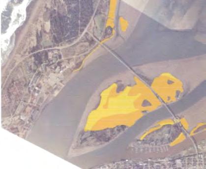
14 Cover Spartina densiflora 5-69%:Sparse--Moderate 70%+:Dense Coastline Meters Distribution of Spartina densiflora in Humboldt Bay, 2000 (after USFWS 2001). 5


15


16


17


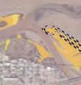
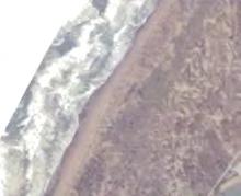
18 Exhibit 3: Photos Exhibit 3. Photographs of Dense-flowered Cordgrass in Project Area Dense-flowered cordgrass forming a continuous meadow on the salt marsh near the mouth of Jacoby Creek, Humboldt Bay National Wildlife Refuge. Dense-flowered cordgrass at the Eel River estuary.

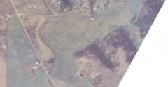
19 Exhibit 3: Photos Brackish marsh with dense-flowered cordgrass at the Mad River estuary.

20 Exhibit 3: Photos Spartina on banks of Mad River estuary,

21 Exhibit 3: Photos Spartina growing more vigorously at lower elevation on bare mud than in higher adjacent salt marsh, Manila

22 Exhibit 3: Photos Spartina growing low in elevation and eroded, in sandy overwash area, Fairhaven


23 Exhibit 3: Photos Experimental cordgrass eradication plot at Humboldt Bay NWR, one year after treatment completed, Reddish vegetation is native pickleweed. Volunteers planting native salt marsh plants into an area from which dense-flowered cordgrass was eradicated, Humboldt Bay NWR.
24 Exhibit 4: Letters of Support STATE CAPITOL P.O. BOX SACRAMENTO, CA PH (916) FAX (916) DISTRICT OFFICES: 50 D STREET, SUITE 450 SANTA ROSA, CA PH (707) FAX (707) N. STATE STREET UKIAH, CA PH (707) FAX (707) TH STREET, SUITE C EUREKA, CA PH (707) FAX (707) ~ssrtuhl\! QIalifnruia~rgislafurr PATTYBERG ASSEMBLYMEMBER, FIRST DISTRICT COMMITTEES: AGING& LONG-TERM CARE, CHAIR BUDGET SUB #1, HEALTH & HUMAN SERVICES, CHP BUDGET HEALTH INSURANCE April 8, 2008 Mr. Doug Bosco, Chair California Coastal Conservancy 1330 Broadway, 13thfloor Oakland, CA Re: Support for Humboldt Bay Regional Spartina Eradication Plan DearMr.BY': &~. I am pleased to offer my support for the Conservancy's authorization of $210,000 in funds for the preparation of the Humboldt Bay Regional Spartina Eradication Plan. The goal of the proposed project is to develop a regional invasive cordgrass eradication plan for the HumboldtBay, Eel River and Mad River estuaries, in order to restore and protect the native plants and wildlife of the tidal marshes in these areas. I understand that invasive cordgrass has come to dominate an estimated 90% of salt marshes in these three adjacent estuaries and now threatens to spread to recently restored marshes. Furthermore, cordgrass in Humboldt Bay and adjacent estuaries have the potential to colonize other west coast estuaries through dispersal of its seeds by the ocean. The eradication plan will be a collaborative effort toward the protection and restoration of our marshes and estuaries and the vital biodiversity they support. I urge the Conservancy's support for this important project. In can provide any further information, please do not hesitate to contact me. Respectfully, VJ~~ PATTY BERG, AssemblYwoman, 1stDistrict - -, ~. - r,-
25 May-OB-200B10:0Bam From-SENATORWIGGINS Exhibit 4: Letters of Support T-163 P,002/002 F-203 c.:p1tol0,.",,,= STATE CAPITOL. RoO", 40B I SACRAMENTO, CA 9.!5B14 TEL FA){191&) 323-ea.!5B aialifnrnin J$tate J$enah SENATOR PATRICIA WIGGINS SECOND SENATE DISTRICT STANCINC CO"''''ITTI:I:S, PUBLIC :M~VEE$ R 'nrement CHAIFI BANKING. FINANCE. INSURANCE energy, I.lTlUTES. COMMuNICATION$ SEUECT COI<IMITTEES; CAUFClRNIA'$ WINE INCUSTRV, C""',,, May 6, 2008 Mr. Doug Bosco, Chair California Coastal Conservancy 1330 Broadway, 13\hfloor Oakland, CA Re: Suppor-t for Humboldt Bay Regional Spartina Eradication Plan Dear Mr. Bosco, I am writing to express SUPPOI1 for the Conservancy's authorization of funds for the preparation of the Humboldt Bay Regional SpaI1inaEradication Plan. I.understand that this invasive densenowcrcd cordgrass, has come to dominate an estimated 90% of salt marshes in the three adjacent estuaries of Humboldt Bay, the Eel River Delta, and the Mad River Estuary. Furthermore, cordgrass in Humboldt Bay and adjacent esruaiies threatens to colonize other west coast estuaries via ocean dispersal of its seeds. In light of the historical loss of90% of the wetlands in HWTlboldtBay, it is critical that we come logether to plan for the protection and restoration of our remaining marshes and the biodiversity they support. r encourage the Conservancy to take this important step to protect and restore the tidal marshes in Humboldt Bay, the Mad River estuary,and the Eel River estuary. Sincerely, yt ~. Pfr!~~ Senator, 2nd DiStrICt PW:zg VAL.LE.lOOJ~IIICT O~~I~!! 444 GEORGIA STREET VAI.L JO. CA O45ao T1:~ ('707) GAB'53 I~ ~AX1)071 S48-~ ""Po. O,GTFI,C"/OFFICE 1040 MAIN $TREET. SuiTe ~ NAPA. CA!l45S0 TF.L(707 J 224- t 0110,.~ A.11)!)~ ~..NTA FlO5AO,9TR'CT OFFIce!SOC $TRI!ET, SUITE 120A SANTA ROSA. CA 'Js-t04 T J e:'&'27'71 FAJC170'71!l7S.2773 P("'lrII1C11I1~P_r ~...1<,.." C"::TRICTOFFICe: 1"0 BO)( 7es Ut<,AJ~.CA 9'~ TEI.,707) p~ (707) 4tlS-e931 EUREI<A "1~TI1rCT OF'F1CE 710 e STREET. SUITE ISO EUREKA, CA 9~' TEL ( esoe FA)(!707J
26 Exhibit 4: Letters of Support BOARD OF SUPERVISORS COUNTY OF HUMBOLDT 825 5TH STREET EUREKA, CALIFORNIA PHONE (707) FAX (707) May 6, 2008 Mr. Doug Bosco, Chair California Coastal Conservancy 1330 Broadway, 13thfloor Oakland, CA Re: Support for Humboldt Bay Regional Spartina Eradication Plan Dear Mr. Bosco, I am writing to express support for the Conservancy's authorization of funds for the preparation ofthe Humboldt Bay Regional Spartina Eradication Plan. Spartina densiflora, or invasive dense-flowered cordgrass, has come to dominate an estimated 90% of salt marshes in the three adjacent estuaries of Humboldt Bay, the Eel River Delta, and the Mad River Estuary. Invasive cordgrass is knownto displace native vegetation, reducing the biodiversity of the salt marsh dramatically, and has recently been spreading from the mid-elevation marsh to the high marsh, where it threatens an even more diverse plant community that includes two rare plant species, Point Reyes bird's beak and Humboldt Bay owl's clover. Invasive cordgrass threatens to colonize newly restored marshes and to spread to the remaining marshes still dominated by indigenous plant species. Furthermore, cordgrass in Humboldt Bay and adjacent estuaries threatens to colonize other west coast estuaries via ocean dispersal of its seeds. In light of the historical loss of90% ofthe wetlands in Humboldt Bay, it is critical that we come together to plan for the protection and restoration of our remaining marshes and the biodiversity they support. I hope that the Conservancy will take this important step to protect and restore the tidal marshes in Humboldt Bay, the Mad River estuary, and the Eel River estuary. Sincerely, ~I Bonnie Neely, 4th Distric County of Humboldt BN:kh RECEIVED MAY UOASTAlCONSERVANCy OAKLAND,CALIF.
27 Exhibit 4: Letters of Support BOARD OF SUPERVISORS COUNTY OF HUMBOLDT 825 5TH STREET EUREKA, CALIFORNIA PHONE (707) FAX (707) May 13, 2008 Mr. Doug Bosco, Chair California Coastal Conservancy 1330 Broadway, 13thfloor Oakland, CA Re: Invasive Spartina Eradication Project Dear Chairman Bosco: On behalf of the Humboldt County Board of Supervisors, I am writing to express support for the State Coastal Conservancy's authorization of funds for the preparation of the Humboldt Bay Regional Spartina Eradication Plan. The goal ofthis project is to develop a regional invasive cordgrass eradication plan for the Humboldt Bay, Eel River, and Mad River Estuaries, in order to restore and protect the native plant and wildlife communities of tidal marshes in these areas. Spartina densiflora, or invasive dense-flowered cordgrass, has come to dominate an estimated 90% of salt marshes in the three adjacent estuaries of Humboldt Bay, the Eel River Delta, and the Mad River Estuary. Invasive cordgrass is known to displace native vegetation, reducing the biodiversity of the salt marsh dramatically, and has recently been spreading from the mid-elevation marsh to the high marsh, where it threatens an even more diverse plant community that includes two rare plant species, Point Reyes bird's beak and Humboldt Bay owl's clover. Invasive cordgrass threatens to colonize newly restored marshes and to spread to the remaining marshes still dominated by indigenous plant species. Furthermore, cordgrass in Humboldt Bay and adjacent estuaries threatens to colonize other west coast estuaries via ocean dispersal of its seeds. In light of the historical loss of90% of the wetlands in Humboldt Bay, it is critical that we come together to plan for the protection and restoration of our remaining marshes and the biodiversity they support. The Board respectfully requests that the Conservancy take this important step to protect and restore the tidal marshes in Humboldt Bay, the Mad River estuary, and the Eel River estuary. Sincerely, RECEIVED Jin.,:Geist, Chair umboldt County Board of Supervisors JG:kh MAY , COASTALCONSERVANCY AJ\I,<LAND, CA,LIF.
Planning for the Future of Humboldt Bay: Sea Level Rise, Sediment Management, Sand Spits and Salt Marshes. Joel Gerwein
 Planning for the Future of Humboldt Bay: Sea Level Rise, Sediment Management, Sand Spits and Salt Marshes Joel Gerwein Introduction to Humboldt Bay Setting Economy, community, and environment Sediment
COASTAL CONSERVANCY. Staff Recommendation June 29, 2006 HUMBOLDT BAY REFUGE SPARTINA DENSIFLORA ERADICATION
 COASTAL CONSERVANCY Staff Recommendation June 29, 2006 HUMBOLDT BAY REFUGE SPARTINA DENSIFLORA ERADICATION File No. 06-065 Project Manager: Melanie Denninger RECOMMENDED ACTION: Authorization to disburse
3.7 VISUAL RESOURCES Environmental Setting
 2 3 4 5 6 7 8 9 0 2 3 4 5 6 7 8 9 20 2 22 23 24 25 26 27 28 29 30 3 32 33 34 35 36 37 38 39 40 4 3.7 VISUAL RESOURCES This section assesses the effects of the treatment techniques on views from public
7.34 Spartina (Spartina anglica)
") 7.34 Spartina (Spartina anglica) Why is it a threat? Spartina is a sward forming grass that originates from the United Kingdom. It grows from underground rhizomes. The rhizomes break off and establish
7.34 Spartina (Spartina anglica) Why is it a threat? Spartina is a sward forming grass that originates from the United Kingdom. It grows from underground rhizomes. The rhizomes break off and establish
Ecological Land Cover Classification For a Natural Resources Inventory in the Kansas City Region, USA
 Ecological Land Cover Classification For a Natural Resources Inventory in the Kansas City Region, USA by Applied Ecological Services, Inc. In cooperation with the Mid-America Regional Council 600 Broadway,
Home About Us Articles Press Releases Image Gallery Contact Us Media Kit Free Subscription 10/5/2006 5:56:35 PM
 Home About Us Articles Press Releases Image Gallery Contact Us Media Kit Free Subscription 10/5/2006 5:56:35 PM Industry Resources Industry Directory NASA Links Missions/Launches Calendar Human development
OREGON POPULATION FORECAST PROGRAM
 OREGON POPULATION FORECAST PROGRAM PROGRAM OVERVIEW BACKGROUND Beginning in 1973 with the passage of Senate Bill (SB) 100, Oregon s growth management system has relied on population forecasts as the primary
Coastal Environment. Introduction. 4.1 Coastal Environment. Extent of Coastal Environment
 4 The primary objective (set out in Chapter 2) to be implemented by this Chapter is Objective 2.4 ; the following objectives are also relevant due to the objectives integrated nature: 2.1 Tāngata whenua
Columbia Estuary Province
 Rolling Provincial Review: Implementation 2001-2004 Province 73 Columbia Basin Fish & Wildlife Authority Province FY 2001-2004 Spending Summaries NPCC Recommendations and BPA Spending by Project Category,
Lower South Fork McKenzie River Floodplain Enhancement Project
 Lower South Fork McKenzie River Floodplain Enhancement Project McKenzie River Ranger District Willamette National Forest Project Location The project is located in the South Fork McKenzie River Watershed,
EAGLES NEST AND PIASA ISLANDS
 EAGLES NEST AND PIASA ISLANDS HABITAT REHABILITATION AND ENHANCEMENT PROJECT MADISON AND JERSEY COUNTIES, ILLINOIS ENVIRONMENTAL MANAGEMENT PROGRAM ST. LOUIS DISTRICT FACT SHEET I. LOCATION The proposed
Summary Description Municipality of Anchorage. Anchorage Coastal Resource Atlas Project
 Summary Description Municipality of Anchorage Anchorage Coastal Resource Atlas Project By: Thede Tobish, MOA Planner; and Charlie Barnwell, MOA GIS Manager Introduction Local governments often struggle
Sunset Harbour / Huntington Harbour Maintenance Dredging and Waterline Installation Project. CMANC 21 January 2016
 Sunset Harbour / Huntington Harbour Maintenance Dredging and Waterline Installation Project CMANC 21 January 2016 County of Orange Footprint Huntington Harbour Operational and Dredging Cost Sharing Agreements
Learning Objectives: I can identify and interpret river flows and directions.
 Learning Objectives: I can identify and interpret river flows and directions. Bellringer Review: Check for Understanding Questions: 1 2 What Are The Key Parts Of A River s Anatomy? In your data notebooks
Sediment Management in the Coastal Bays
 Sediment Management in the Coastal Bays Introduction Need for ecosystem view of sediment management in Coastal Bays Island loss and restoration Navigation needs Habitat Trade offs Living Shoreline Requirements
Regional Sediment Management
 Regional Sediment Management Linda S. Lillycrop Program Manager Coastal Engineer US Army Engineer Research and Development Center Coastal and Hydraulics Laboratory Q AVG Coastal Resilience: The Environmental,
United States Department of the Interior NATIONAL PARK SERVICE Northeast Region
 United States Department of the Interior NATIONAL PARK SERVICE Northeast Region June 17, 2017 REQUEST FOR STATEMENTS OF INTEREST and QUALIFICATIONS Project Title: ASSESSMENT OF NATURAL RESOURCE CONDITION
Proposed Scope of Work Village of Farmingdale Downtown Farmingdale BOA Step 2 BOA Nomination Study / Draft Generic Environmental Impact Statement
 Proposed Scope of Work Village of Farmingdale Downtown Farmingdale BOA Step 2 BOA Nomination Study / Draft Generic Environmental Impact Statement The scope of work that follows incorporates and covers
Heather Schlosser Army Corps of Engineers Coastal Studies Group August 28, 2008
 Got sand? Regional Sediment Management in Orange County Heather Schlosser Army Corps of Engineers Coastal Studies Group August 28, 2008 Regional Sediment Management Regional sediment management recognizes
15 March 2010 Re: Draft Native Vegetation of the Sydney Metropolitan Catchment Management Authority Area GIS layers and explanatory reports
 SYDNEY COASTAL COUNCILS GROUP Inc. C/- City of Sydney Council Level 14, 456 Kent Street GPO Box 1591, SYDNEY NSW 2001 Phone: (02) 9246 7791 Facsimile: (02) 9265 9660 Email: info@sydneycoastalcouncils.com.au
Exhibit IV-1: Initiation of Zoning Map Amendments Case Report HEARING DATE: MAY 3, 2012
 Exhibit IV-1: Initiation of Zoning Map Amendments Case Report HEARING DATE: MAY, 01 Case No.: 00.0MTZU Transit Center District Plan Amendments to Zoning Map Staff Contact: Joshua Switzky - (1) -1 joshua.switzky@sfgov.org
Solutions to Flooding on Pescadero Creek Road
 Hydrology Hydraulics Geomorphology Design Field Services Photo courtesy Half Moon Bay Review Solutions to Flooding on Pescadero Creek Road Prepared for: San Mateo County Resource Conservation District
Name: Date: Class: Louisiana: Our History, Our Home Chapter 1: Louisiana s Geography - Section 2: Natural Regions Guided Reading
 Instructions: Read the section and complete each item with words from the passages in this section. 1. The diversity of Louisiana s can surprise residents and visitors alike. 2. Physical geography is concerned
Overview of Methods. Terrestrial areas that are most important for conservation Conservation
 Overview of Methods The goal of the Western Lake Erie Coastal Conservation Vision project (WLECCV) is to define where we should be working locally to optimally achieve regional conservation impact. The
Background. North Cascades Ecosystem Grizzly Bear Restoration Plan/ Environmental Impact Statement. Steve Rochetta
 Grizzly Bear Restoration Plan/ Environmental Impact Statement Steve Rochetta Background Situated in the core of the North Cascades ecosystem (NCE), the North Cascades National Park Complex is surrounded
State GIS Officer/GIS Data
 State GIS Officer/GIS Data This Act creates the position of state Geographic Information Systems (GIS) officer. The Act: requires the state GIS officer to adopt or veto the GIS data standards and a statewide
Relatively little hard substrate occurs naturally in the
 CHAPTER FIVE Rock Habitats Relatively little hard substrate occurs naturally in the estuary, owing mainly to the vast quantities of fine sediment that have been deposited by the rivers. Rock habitat is
A Comprehensive Inventory of the Number of Modified Stream Channels in the State of Minnesota. Data, Information and Knowledge Management.
 A Comprehensive Inventory of the Number of Modified Stream Channels in the State of Minnesota Data, Information and Knowledge Management Glenn Skuta Environmental Analysis and Outcomes Division Minnesota
Application #: TEXT
 TOWN OF FORT MYERS BEACH 2008 PROPOSED COMPREHENSIVE PLAN AMENDMENTS Application #: 2008-13-TEXT Description: Modify the Coastal Management and Future Land Use Elements to reflect the state s new definition
Understanding and fighting the invasion of Spartina densiflora Humboldt Bay (California, USA) & the Gulf of Cádiz (Andalusia, Spain)
 & the Gulf of Cádiz (Andalusia, Spain)") Understanding and fighting the invasion of Spartina densiflora Humboldt Bay (California, USA) & the Gulf of Cádiz (Andalusia, Spain) Jesús M. Castillo The main threat to the conservation of salt marshes
Understanding and fighting the invasion of Spartina densiflora Humboldt Bay (California, USA) & the Gulf of Cádiz (Andalusia, Spain) Jesús M. Castillo The main threat to the conservation of salt marshes
GOAL 7 AREAS SUBJECT TO NATURAL DISASTERS AND HAZARDS. To protect life and property from natural disasters and hazards.
 GOAL 7 AREAS SUBJECT TO NATURAL DISASTERS AND HAZARDS A. GOALS: To protect life and property from natural disasters and hazards. B. POLICIES: 1. Floodplains shall be maintained as natural drainage-ways.
MISSOURI LiDAR Stakeholders Meeting
 MISSOURI LiDAR Stakeholders Meeting East-West Gateway June 18, 2010 Tim Haithcoat Missouri GIO Enhanced Elevation Data What s different about it? Business requirements are changing.fast New data collection
Design of Levee Breaches in Sheltered Water for Flood Risk Reduction & Marsh Restoration ASFMP; June 5, 2014 Presented By:
 Design of Levee Breaches in Sheltered Water for Flood Risk Reduction & Marsh Restoration ASFMP; June 5, 2014 Presented By: Rohin Saleh Alameda County Flood Control District Matt Powers, P.E. GEI Consultants
Chapter 3 - White Oak River Subbasin Includes Bogue Sound and the Newport River
 Chapter 3 - White Oak River Subbasin 03-05-03 Includes Bogue Sound and the Newport River 3.1 Water Quality Overview Subbasin 03-05-03 at a Glance Land and Water Area (sq. mi.) Total area: 228 Land area:
 BPC Policy No , IIM7fyilK Office of the District Clerk TRANSITION ZONE POLICY")
Birch Creek Geomorphic Assessment and Action Plan
 Birch Creek Geomorphic Assessment and Action Plan Jim Webster Tim Hanrahan, PhD, CFM Jesse Schwartz, PhD Zach Hill January 22, 2015 White Eagle Grange This Project is a First Step in Strategy Planning
Savannah District s Revised SOP: Moving Towards A Functional Approach. US Army Corps of Engineers BUILDING STRONG
 Savannah District s Revised SOP: Moving Towards A Functional Approach US Army Corps of Engineers Agenda SOP Revision Concept New Aquatic Resource Credit Types New Urban Mitigation Service Area Filter Background
Mapping Maine s Working Waterfront: for Our Heritage and Economy
 Mapping Maine s Working Waterfront: for Our Heritage and Economy Abstract Mapping Maine s Working Waterfronts is a collaborative project led by the Island Institute that inventories the state s current
Outline National legislative & policy context Regional history with ESSIM ESSIM Evaluation Phase Government Integration via RCCOM Regional ICOM Framew
 What MSP Implementation could change in the Maritimes Region Tim Hall, Regional Manager Oceans and Coastal Management Division Ecosystem Management Branch Fisheries and Oceans Canada Maritimes Region BIO
EXECUTIVE SUMMARY (Continued)
") EXECUTIVE SUMMARY In 1980, Congress passed the Pacific Northwest Electric Power Planning and Conservation Act which authorized creation of the Northwest Power and Conservation Council by the states of
EXECUTIVE SUMMARY In 1980, Congress passed the Pacific Northwest Electric Power Planning and Conservation Act which authorized creation of the Northwest Power and Conservation Council by the states of
1. PURPOSE 2. PERIOD OF PERFORMANCE
 Statement of Work Herbarium Voucher Collection Land Management Section, Environmental Security Department Marine Corps Installations West Marine Corps Base Camp Pendleton, California 1. PURPOSE The purpose
Coastal Impacts of Climate Change in the Northwest: A Summary of the Findings of the upcoming National Climate Assessment
 Western Washington University Western CEDAR Salish Sea Ecosystem Conference 2014 Salish Sea Ecosystem Conference (Seattle, Wash.) May 1st, 3:30 PM - 5:00 PM Coastal Impacts of Climate Change in the Northwest:
Wetland Sediment Dynamics at Crissy Field Marsh Annual Report
 Wetland Sediment Dynamics at Crissy Field Marsh 27 Annual Report John Callaway Department of Environmental Science University of San Francisco 217 Fulton St. San Francisco, CA 94117 (415) 422-572 callaway@usfca.edu
Pablo Bay in Sonoma, Solano, and Napa Counties. It is owned and managed by the U.S. Fish and Wildlife
 Appendix L San Pablo Bay Marsh Introduction San Pablo Bay National Wildlife Refuge marsh (hereafter San Pablo) is located on the north shore of San Pablo Bay in Sonoma, Solano, and Napa Counties. It is
 Red River Flooding June 2015 Caddo and Bossier Parishes Presented by: Flood Technical Committee Where the Rain Falls Matters I-30 versus I-20 I-20 Backwater and Tributary Floods (Localized) 2016 Flood
Sustainable Groundwater Management Act: Initial Notification of a Proposed Basin Boundary Modification
 Sustainable Groundwater Management Act: Initial Notification of a Proposed Basin Boundary Modification Proposed Boundary Modification The Butte County Department of Water and Resource Conservation has
Assessment. Assessment
 2001 SPRINGBROOK CREEK RESTORATION - THREE YEAR POST-CONSTRUCTION REVIEW - Presented by Bruce Henderson and Andy Harris 2005 River Restoration Northwest Symposium Skamania Lodge, Washington www.hendersonlandservices.com
Quarterly Report. 01 July 30 September 2014
 Quarterly Report Faculty of FORESTY School of AGRICULTURAL, FOREST, AND ENVIRONMENTAL SCIENCES College of AGRICULTURE, FORESTRY & LIFE SCIENCES Baruch Institute of Coastal Ecology and Forest Sciences Hwy.
Presentation Outline. Project Overview. Sea Level Rise Assessment & Decision Tools. Community Engagement. Tina Whitman, Friends of the San Juans
 Healthy Beaches for People & Fish Sea Level Rise Adaptation Tools for San Juan County, WA Tina Whitman & Andrea MacLennan December 10, 2015 Presentation Outline Project Overview Tina Whitman, Friends of
Economic and Social Council
 United Nations Economic and Social Council Distr.: General 18 July 2016 Original: English Committee of Experts on Global Geospatial Information Management Sixth session New York, 3-5 August 2016 Item 2
Restoring the Napa River:
 Restoring the Napa River: lessons learned from a long term private-public project Andy Collison Environmental Science Associates acollison@esassoc.com 1 Napa River Restoration Projects Rutherford Reach
Smooth Cordgrass Varieties. Description and Performance
 Smooth Cordgrass Varieties Description and Performance Smooth cordgrass (Spartina alterniflora Loisel.) is a perennial grass native to intertidal saline marshes along the Gulf of Mexico and Atlantic coasts.
HAMILTON DECLARATION ON COLLABORATION FOR THE CONSERVATION OF THE SARGASSO SEA
 HAMILTON DECLARATION ON COLLABORATION FOR THE CONSERVATION OF THE SARGASSO SEA Hamilton, Bermuda 11 March, 2014 WE, THE SIGNATORIES LISTED BELOW: Recognising that the islands of Bermuda are the only land
Wisconsin s Invasive Species Classification Assessment and Rule
 Wisconsin s Invasive Species Classification Assessment and Rule The Process Legislature gave WIDNR authority to create an invasive species classification system. Legislature also created Wis. Council on
The Refugia Concept: Using Watershed Analysis to Prioritize Salmonid Habitat for Conservation and Restoration
 The Refugia Concept: Using Watershed Analysis to Prioritize Salmonid Habitat for Conservation and Restoration Christopher May Battelle & UW Cumulative Impacts of Urbanization Landscape Alterations Loss
Sri Lanka has a coastline of km excluding the shoreline of bays and inlets.
 Defining and Demarcating Coastal zones in Sri Lanka Procedure, Challenges and What needs to be done? Dr. Anil Premaratne Director General Coast Conservation Coast Conservation Department Sri Lanka 1 Sri
Cross-border Maritime Spatial Plan for the Black sea - Romania and Bulgaria project
 Cross-border Maritime Spatial Plan for the Black sea - Romania and Bulgaria project in Romania and Bulgaria Plan Presentation A first step in the management of the marine areas of Romania and Bulgaria
Dark Sky Initiative Draft Terms of Reference
 Dark Sky Initiative Draft Terms of Reference July 2008 Table of Contents 1.0 Introduction 2 2.0 Initiative intent 2-3 3.0 Initiative goals 3 4.0 Legislation 3 5.0 Municipal Development Plan 3 6.0 Land
PROPOSED UNESCO FUNDY BIOSPHERE RESERVE
 OVERVIEW PROPOSED UNESCO FUNDY BIOSPHERE RESERVE NEW BRUNSWICK, CANADA NOMINATION DOCUMENT April 10, 2007 The United Nations Educational, Scientific and Cultural Organization (UNESCO) Man and the Biosphere
Third Annual Monitoring Report Tidal Wetland Restoration 159 Long Neck Point Road, Darien, CT NAE
 1) Project Overview Third Annual Monitoring Report Tidal Wetland Restoration 159 Long Neck Point Road, Darien, CT NAE-2007-1130 December 15, 2014 This is the third year of a five year monitoring program
Napa Valley Groundwater Sustainability: A Basin Analysis Report for the Napa Valley Subbasin
 Napa Valley Groundwater Sustainability: A Basin Analysis Report for the Napa Valley Subbasin A report prepared pursuant to California Water Code Section 10733.6(b)(3) EXECUTIVE SUMMARY (354.4(A)) 1 1.0
Baseline Estuarine-Upland Transition Zone
 Baseline Estuarine-Upland Transition Zone in SF, San Pablo and Suisun Bays 10/5/18 Prepared for San Francisco Bay Joint Venture (SFBJV) Prepared by Brian Fulfrost, Principal bfaconsult@gmail.com with additional
Sea Level Rise Providing Nature A-Right-of Way
 Sea Level Rise Providing Nature A-Right-of Way Study Area Site 2: Skagit Bay Initial Condition 11.2 Inches by 2050 No Dikes 27.3 Inches by 2100 No Dikes The Problem Loss of coastal wetlands due to submergence
Subcommittee on Sedimentation Draft Sediment Analysis Guidelines for Dam Removal
 Subcommittee on Sedimentation Draft Sediment Analysis Guidelines for Dam Removal August 4, 2011 Jennifer Bountry, M.S., P.E. Tim Randle, M.S., P.E., D.WRE. Blair Greimann, Ph.D., P.E. Sedimentation and
Kate Labrum
 2010-2011 Bren Group Project Proposal Boats, Whales, & the Santa Barbara Channel: An economic analysis & policy options for reducing the risk of vessel strikes to endangered whales Bren Student Proposers
WHITE WOLF GSA ACCOMPLISHMENTS AND SHORT-TERM SGMA COMPLIANCE GOALS
 WHITE WOLF GSA ACCOMPLISHMENTS AND SHORT-TERM SGMA COMPLIANCE GOALS 22 AUGUST 2017 OUTLINE SGMA Compliance Timeline Accomplishments to Date SGMA Road Map for the White Wolf Subbasin 2042 2022 2017 2016
A Regional Database Tracking Fire Footprint Each Year within the South Atlantic Region: Current Database Description and Future Directions
 A Regional Database Tracking Fire Footprint Each Year within the South Atlantic Region: Current Database Description and Future Directions Last Updated on September 30, 2018 Contributors: NatureServe,
Carbon Sequestration Potential from Coastal Wetlands Restoration Sites
 Carbon Sequestration Potential from Coastal Wetlands Restoration Sites Insert then choose Picture select your picture. Right click your picture and Send to back. Paul Krause, Alyssa Beach Emily Cooper,
Management Planning & Implementation of Communication Measures for Terrestrial Natura 2000 Sites in the Maltese Islands Epsilon-Adi Consortium
 Management Planning & Implementation of Communication Measures for Terrestrial Natura 2000 Sites in the Maltese Islands Epsilon-Adi Consortium Briefing Meetings, February 2013 CT3101/2011, MEPA, Malta
THE SEVILLE STRATEGY ON BIOSPHERE RESERVES
 THE SEVILLE STRATEGY ON BIOSPHERE RESERVES 1 VISION FOR BIOSPHERE RESERVES IN THE 21 ST CENTURY The international Seville Conference on Biosphere Reserves, organised by UNESCO, adopted a two-pronged approach,
IMA s ROLE IN COASTAL AND OCEAN GOVERNANCE IN TRINIDAD AND TOBAGO
 IMA s ROLE IN COASTAL AND OCEAN GOVERNANCE IN TRINIDAD AND TOBAGO Presented by Rahanna Juman, Deputy Director (Ag.) About the Institute of Marine Affairs Institute of Marine Affairs (IMA) was established,
HELSINKI COMMISSION Baltic Marine Environment Protection Commission
 HELSINKI COMMISSION Baltic Marine Environment Protection Commission HELCOM RECOMMENDATION 24/10 Adopted 25 June 2003, having regard to Article 20, Paragraph 1 b) of the 1992 Helsinki Convention IMPLEMENTATION
Statutory framework of the world network of biosphere reserves UNESCO General Conference 1996
 Statutory framework of the world network of biosphere reserves UNESCO General Conference 1996 Keywords: conservation, protected areas, biosphere reserves, policies, strategies. For the Mountain Forum's
Sea Level Rise and the Public Trust Doctrine:
 Sea Level Rise and the Public Trust Doctrine: Meeting Coastal Governance Challenges in the Face of Climate Change www.remote.ucdavis.edu Department ofwater Resources www.rwongphoto.com Jennifer DeLeon
Population Trends Along the Coastal United States:
 Coastal Trends Report Series Population Trends Along the Coastal United States: 1980-2008 U.S. Department of Commerce National Oceanic and Atmospheric Administration National Ocean Service Assessing the
Management of Spartina anglica in the Fraser River estuary, British Columbia
 Management of Spartina anglica in the Fraser River estuary, British Columbia Gary Williams GL Williams & Associates Ltd. White Rock & Surrey Naturalists Society May 12 th, 2005 White Rock, BC Presentation
Island Design. UMRS EMP Regional Workshop. Presentation for the
 Island Design Presentation for the UMRS EMP Regional Workshop by Jon Hendrickson Hydraulic Engineer Regional Technical Specialist, Water Quality and Habitat Restoration August 17 19, 2005 Project Delivery
Randall W. Parkinson, Ph.D., P.G. Institute of Water and Environment Florida International University
 An Update on Adaptation Action Activities Undertaken Since Completion of the City of Satellite Beach (FL) Vulnerability Assessment to Rising Seas (2010) Randall W. Parkinson, Ph.D., P.G. Institute of Water
Date: June 19, 2013 Meeting Date: July 5, Consideration of the City of Vancouver s Regional Context Statement
 Section E 1.5 To: From: Regional Planning and Agriculture Committee Lee-Ann Garnett, Senior Regional Planner Planning, Policy and Environment Department Date: June 19, 2013 Meeting Date: July 5, 2013 Subject:
Butte County Board of Supervisors Agenda Transmittal
 Butte County Board of Supervisors Agenda Transmittal Clerk of the Board Use Only Agenda Item: 3.38 Subject: Resolution to Establish the Butte County Groundwater Sustainability Agency in the West Butte
Edward R. Sajecki Commissioner of Planning and Building. Conservation Authority Regulations and Mapping
 Corporate Report Clerk s Files Originator s Files EC.19.CON DATE: TO: FROM: SUBJECT: Chair and Members of Planning and Development Committee Meeting Date: April 3, 2006 Edward R. Sajecki Commissioner of
ACRONYMS AREAS COUNTRIES MARINE TERMS
 Natura 2000 ACRONYMS AREAS COUNTRIES MARINE TERMS DEFINITION A European network of protected sites under the European Habitats and Birds Directives, aiming to protect the most valuable and threatened European
Descriptions and Performance
 LSU AgCenter Coastal Plants Program Smooth Cordgrass Varieties: Descriptions and Performance Smooth cordgrass (Spartina alterniflora Loisel.) is a perennial grass native to intertidal saline marshes along
Designing Networks of Marine Protected Areas in DFO s Three Atlantic Bioregions
 Designing Networks of Marine Protected Areas in DFO s Three Atlantic Bioregions Presentation for Indigenous Protected Areas Workshop Max Westhead, DFO and Adrian Gerhartz-Abraham, Dalhousie March 29, 2017
THE USE OF GEOSPATIAL DATA TO SUPPORT VULNERABILITY MAPPING OF THE OREGON COAST. Kelvin Raiford MS Candidate Geography Department of Geosciences
 THE USE OF GEOSPATIAL DATA TO SUPPORT VULNERABILITY MAPPING OF THE OREGON COAST Kelvin Raiford MS Candidate Geography Department of Geosciences INTRODUCTION This study is an outcome of the project Geospatial
Second Annual Monitoring Report Tidal Wetland Restoration 159 Long Neck Point Road, Darien, CT NAE
 1) Project Overview Second Annual Monitoring Report Tidal Wetland Restoration 159 Long Neck Point Road, Darien, CT NAE-2007-1130 December 13, 2013 This is the second year of a five year monitoring program
cooperating sites as the three initial units of a new Southern Appalachian Biosphere Reserve, approved by UNESCO in 1988.
 -» TOWARD A U.S. MODALITY OF BIOSPHERE RESERVES: THE SOUTHERN APPALACHIAN BIOSPHERE RESERVE William s_ P. Gregg, Chief, International Affairs Office, National Biological Service, Washington, D.C. Hubert
Briefing. H.E. Mr. Gyan Chandra Acharya
 Briefing by H.E. Mr. Gyan Chandra Acharya Under-Secretary-General and High Representative for the Least Developed Countries, Landlocked Developing Countries and Small Island Developing States Briefing
APPLICATION TO AMEND THE FUTURE LAND USE MAP (FLUM) SMALL SCALE
 SMALL SCALE") DEPARTMENT OF DEVELOPMENT & PLANNING 825 Ohio Avenue - Lynn Haven, FL 32444 (850) 265-2961 - (850) 265-3478 APPLICATION TO AMEND THE FUTURE LAND USE MAP (FLUM) SMALL SCALE Deadline to submit is 30 days
DEPARTMENT OF DEVELOPMENT & PLANNING 825 Ohio Avenue - Lynn Haven, FL 32444 (850) 265-2961 - (850) 265-3478 APPLICATION TO AMEND THE FUTURE LAND USE MAP (FLUM) SMALL SCALE Deadline to submit is 30 days
Engineer's Report. Main Street Business Area. Festoon Lighting and Sidewalk Cleaning Assessment District (Fiscal Year )
") Engineer's Report for the Main Street Business Area Festoon Lighting and Sidewalk Cleaning Assessment District (Fiscal Year 2008-09) Prepared under the provisions of the Benefit Assessment Act of 1982
Engineer's Report for the Main Street Business Area Festoon Lighting and Sidewalk Cleaning Assessment District (Fiscal Year 2008-09) Prepared under the provisions of the Benefit Assessment Act of 1982
The Arctic Landscape Conservation Cooperative Conservation Goals
 The Arctic Landscape Conservation Cooperative Conservation Goals Adopted by the Arctic LCC Steering Committee, 24 August 2010 Background : Landscape Conservation Cooperatives and Climate Science Centers
Fiscal Year 2017: 3 rd Quarter Status Report. 01 April 30 June, 2017
 Fiscal Year 2017: 3 rd Quarter Status Report BARUCH INSTITUTE OF COASTAL ECOLOGY AND FOREST SCIENCE Highway 17 North PO Box 596 Georgetown, SC 29442-0596 P (843) 546-1013 F (843) 546-6296 01 April 30 June,
4.2 Tidal Wetlands. Phragmites Australis
 4.2 Tidal Wetlands Few topics elicit such strong emotions in Guilford as the current state of salt marshes. These marshes, more broadly known as tidal wetlands, are undergoing a transformation as sea level
TOWARDS CLIMATE-RESILIENT COASTAL MANAGEMENT: OPPORTUNITIES FOR IMPROVED ICZM IN BELIZE
 TOWARDS CLIMATE-RESILIENT COASTAL MANAGEMENT: OPPORTUNITIES FOR IMPROVED ICZM IN BELIZE CHANTALLE SAMUELS Coastal Zone Management Authority and Institute The Caribbean Community Climate Change Centre VULNERABILITY
Project Primary Contact: Gregg Servheen, Idaho Department of Fish and Game, PO Box 25 Boise, ID ,
 Project Title: Idaho Montana Divide Project Objective: Pilot the conceptualization and coordination of a transboundary Decision Support System(DSS) for fish, wildlife, and habitats along the Idaho Montana
1.1 What is Site Fingerprinting?
 Site Fingerprinting Utilizing GIS/GPS Technology 1.1 What is Site Fingerprinting? Site fingerprinting is a planning tool used to design communities where protection of natural resources is the primary
Statewide Topographic Mapping Program
 Statewide Topographic Mapping Program February 28, 2018 www.dotd.la.gov Outline Purpose of the Statewide Topographic Mapping Program History Breakdown of R.S. 48:36 - Topographic Mapping Statewide Topographic
The Science of Coastal and Marine Spatial Planning A Workshop for Oregon Academic Faculty
 The Science of Coastal and Marine Spatial Planning A Workshop for Oregon Academic Faculty November 29 30, 2011 Oregon State University Lisa DeBruyckere, Coordinator West Coast Governors Agreement on Ocean
404 Nationwide Permit: File No. SPL PKK FWS-LA-14B F0556 Streambed Alteration Agreement Notification No.
 HELIX Environmental Planning, Inc. 7578 El Cajon Boulevard La Mesa, CA 91942 619.462.1515 tel 619.462.0552 fax www.helixepi.com July 17, 2017 Ms. Colleen Draguesku Carlsbad Fish and Wildlife Office 2177
Chesapeake Bay Remote Sensing Pilot Executive Briefing
 Chesapeake Bay Remote Sensing Pilot Executive Briefing Introduction In his Executive Order 13506 in May 2009, President Obama stated The Chesapeake Bay is a national treasure constituting the largest estuary