Aviation. Solutions for the real world
|
|
|
- Roland Heath
- 5 years ago
- Views:
Transcription

1 Aviation RVR ARWIS LLWAS MetReporter Fog Prediction Automated Weather Observation System Aviation Weather Decision Support Briefing & Forecasting Workstation Pilot Briefing Weather Prediction ATIS / VOLMET Solutions for the real world

2 MicroStep-MIS operates worldwide and it is specialised in development and manufacturing of monitoring and information systems, data acquisition and processing, research and numerical modeling. The company s key field activities cover: Meteorology and Climatology Aviation Systems Road Weather Information Systems Marine Systems Hydrology - Flood Warning systems Microclimate Cave Monitoring Systems Seismology Radiation Monitoring Systems Air Quality, Emission Monitoring Crisis Information Systems System Integration as well as Turnkey Projects More than 20 years of experience in the field of monitoring and information systems More than 280 aviation systems installed in 25 countries Our global operations include the following customer groups: airports, port authorities, meteorological and seismological institutes, hydrological institutes, environmental authorities, industry, and municipalities. Activities of MicroStep-MIS cover the complete process of software and hardware systems development and integration. Our products and comprehensive services fully comply with the technical as well as quality standards (ISO 9001:2008, ICAO, WMO, EUROCAE), and are supplied under very competitive financial and trade conditions. Our highly qualified staff of developers and experienced researchers, dynamic product development process, and close cooperation with our customers guarantee the development and delivery of the most progressive and outstanding solutions. 2

3 Content IMS4 AWOS Automated Weather Observation System...4 IMS4 MetReporter...5 IMS4 ATIS / VOLMET...6 IMS4 Briefing...7 IMS4 RVR Runway Visual Range System...8 IMS4 ARWIS Airport Runway Weather Information System...9 IMS4 LLWAS Low Level Windshear Alert System...10 IMS4 Fog Prediction...11 Weather Prediction...12 Aero CLDB Aeronautical Climatological Database...13 MMR Mini Meteorological Radar...14 IMS4 AWDSS Aviation Weather Decision Support System


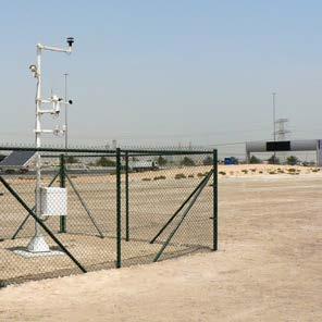
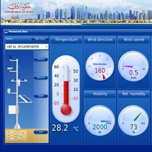
4 IMS4 AWOS Automated Weather Observation System Integrates all airport weather data Scalable up to ICAO category CAT III Conforms to the ICAO and WMO regulations and recommendations Access to AWOS data from Net The IMS4 Automated Weather Observation System is an airport weather observation system for regional, national and international airports. The IMS4 AWOS measures, processes, stores, presents and communicates all meteorological data at the airport, including measurements produced by variety of meteorological sensors, manual observations and WMO codes received from GTS and AFTN. It provides weather data and reports to observers, air traffic controllers, pilots and other users. It generates real-time screens, graphs, WMO codes, alarms and voice reports. Moreover, it interfaces upper air systems, low level windshear alert system and radars. to comprehensive systems for multirunway airport connected to GTS and AFTN networks including a dual hot fail-over Central System, several Observer s Workstations, displays and terminals, briefings and ATIS / VOLMET services. The well-developed upgrade programs allow our systems to follow technology progress and adapt to airport expansion and changes in regulations during its lifetime. Aviation Web Server Within the same airport, or on another continent, IMS4 AWOS provides users with the powerful and efficient web interface. All the user needs in order to view the AWOS data is a standard web browser and Internet connection. The IMS4 AWOS conforms to all ICAO and WMO recommendations regarding the measurements and reporting. It calculates various derived meteorological data such as QNH, QFE and Runway Visual Range. It generates alarms, METAR, SPECI, SYNOP reports, as well as national codes if required. Scalable and flexible The configuration and structure of a respective Airport Weather System depends on the size and category of the individual airport up to ICAO category CAT III. The modular architecture allows the expansion from single Aviation Weather Display with basic set of sensors up 4
, for the general aviation, non-icao")
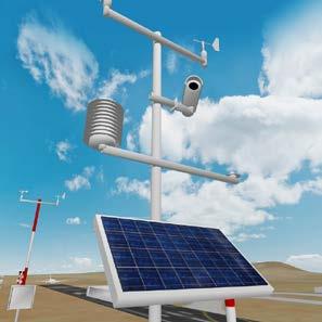
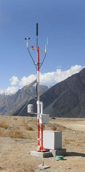
5 IMS4 MetReporter Available 24 hours / 365 days a year Low power consumption Easy to deploy, use & maintain Compliance with the ICAO and WMO regulations and standards Built on the modular and field proven IMS4 AWOS platform, IMS4 MetReporter is an ideal autonomous, easy-to-deploy and easy-to-maintain, fully automated weather observation system (AWOS), for the general aviation, non-icao categorized airports and heliports. The system consist of: Embedded VHF Automated Terminal Information Service Embedded Automated Weather Observation Service: Standard: Wind speed, direction (gust, squall) Temperature / dew point Atmospheric pressure (QNH, QFE, tendency) Visibility (MOR / VIS) / present weather Optional: Cloud base / vertical visibility / sky condition Lightning Precipitation Static view or 360 view camera METAR / SPECI (AUTO) MET REPORT / SPECIAL (AUTO) Real-time screens, archived data in tables / charts Sensor configuration, communication control Remote telemetry and control from local workstation over WiFi or GPRS VPN Optional computer based IMS4 Aviation Weather Display or full featured IMS4 Observer Workstation Optional data reporting to the upper system for flight planning IMS4 Central AWOS server concentrating data from multiple MetReporters or cloud computing provider Meets or exceeds applicable ICAO, WMO, EASA, CAAC regulations and recommendations Sensors - typical configuration Ultrasonic 2D First Class Wind Sensors RHT175 Humidity Probe MSB780 Digital Barometer VPF-700 Series Visibility and Present Weather Sensors Cloud Ceilometer CBME 80 (optional) Lightning Detector (optional) Rain Gauge (optional) Cameras (optional) 5

 with permanent access to AWOS data.")
6 IMS4 ATIS / VOLMET Arrival, Departure or Combined ATIS and VOLMET broadcast and datalink services From regional up to major international airports Easy expansion from single up to the multi-channel ATIS / VOLMET system Open architecture and easy adaptation The IMS4 ATIS / VOLMET system benefits from more than twenty years of MicroStep-MIS experience in the field of meteorological service for civil aviation. It provides Arrival, Departure or Combined ATIS and VOLMET broadcast and datalink services for airports from regional up to major international airports as well. The IMS4 ATIS / VOLMET system can be installed as a standalone system or as an integrated part of the MicroStep-MIS IMS4 Automated Weather Observation System (AWOS) with permanent access to AWOS data. The open architecture allows easy expansion from the basic single channel system (combined departure and arrival ATIS service) up to the multi-channel ATIS / VOLMET system (separate broadcasting channels for airport with multiple runways, multichannel service for group of airports etc.). Software configuration allows easy adaptation to specific airport conditions, national rules, and voice report composition rules. Variety of system options include but are not limited to: multiple channels and/or multiple languages dual hot-failover configuration and/or redundant transmitter equipment as a guaranty of the highest possible system reliability remote operator and control positions for convenient authorized access to the system telephone interface for the preview of current broadcasted reports The IMS4 ATIS / VOLMET user interface is intuitive and easily operated. The fully automated mode allows cost effective operation without human intervention. The semi automated or manual mode can be also configured for specific channels, if required, with visual and audible warnings announcing new data availability and new report compilation. 6


7 IMS4 Briefing IMS4 Briefing supplies meteorological information to aviation users in order to ensure the safety and regularity of air navigation. IMS4 Briefing workstation, either standalone or fully integrated within IMS AWOS, facilitates collecting and printing of flight documentation for pilots based on the local meteorological data and messages received from the GTS or AFTN networks. The IMS Briefing integrates automatic handling of data validation. Users can easily collect and print all necessary flight documentation containing weather conditions locally, at the destination, and along the flight route. A single definition of the flight-route into the system is sufficient for the IMS Briefing to master this task in a few seconds time. Flight-route definition can be performed by the selection of a station list on the basis of ICAO indicators or station names. The stations included in the flight route provide the basis for the generation of the PIB (pre-flight information bulletin). Besides standard PIB information such as OPMET data, SIGWX, and Upper wind-temperature charts, the PIB can contain a cross-section of the temperature and wind conditions along the flight route that also perfectly describe the takeoff and landing conditions. IMS4 Briefing and Forecasting Workstation The software aids meteorological forecaster by visualizing meteorological information and providing templates for standard and local forecasts. Visualization of meteorological information for forecaster: OPMET Radar SADIS Satellite GRIB Lightning BUFR VAAC and TCAC information Soundings other Templates for creation of forecasts and warnings: AIREP TREND AIRMET Wind Shear Warning GAMET other (e.g. warnings Aerodrome Warning according to regional SIGMET agreements) TAF Messages are checked for errors before compilation. GTS / AFTN headers and other automatically available information is filled in by the system. The system warns users about all received meteorological or operational conditions like volcanic ash or tropical cyclone advisories, SIGMETs, AIRMETs, as well as many other warnings and administrative messages. 7
 Standalone system or integrated within AWOS / AWDSS RVR data on the Net The IMS4 Runway Visual Range system performs the automated runway visual range assessment and reporting for")


8 IMS4 RVR Runway Visual Range System Forward scatter technology ICAO compliance with CAT I, II and CAT III Real time data processing / visibility forecasts Multiple sensor interfaces (modem, fiber optic, wireless) Standalone system or integrated within AWOS / AWDSS RVR data on the Net The IMS4 Runway Visual Range system performs the automated runway visual range assessment and reporting for the airports. Field sensors The typical set of IMS4 RVR field measurement system consists of forward scatters, background luminance sensors as well as interfaces to runway lights systems. Multiple types of sensors and communication interfaces are supported. The data processing software enables any standard or non standard combination of sensor positions along the runways, hot backup of the sensor values and manual data entry. For each sensor type, the evaluation and visualization of the sensor status as well as remote maintenance is provided. accordance both with the ICAO regulations as well as respective ATC authority requirements. The built-in aviation web server provides the local airport controllers as well as remote users with the powerful and efficient web interface. IMS RVR Server Whether a standard COTS Intel based server or a dual hot failover Cluster, the IMS RVR server collects the visibility, background luminance and runway lights intensity data from the field measurement system, calculates the RVR, distributes the data to displays as well as 3rd party systems. It also provides operators with alerts related to the significant thresholds of the visibility and/or RVR. In case of the integration of the RVR system into AWOS, the RVR values are displayed on the local as well as remote AWOS screens, are imported into METAR/SPECI and local routine or special reports, may trigger AUTOSPECI or serve as a basis of the airport operation category assessment. Controller Displays Customizable displays report touchdown, midpoint and rollout RVR and/or MOR current values or trends, in 8


9 IMS4 ARWIS Airport Runway Weather Information System Detection and prediction of runway conditions Alarms on hazardous phenomena detected or forecast Effective de-icing Intrusive as well as non-intrusive sensors Multiple sensor interfaces (modem, fiber optic, wireless) Standalone system or integrated within AWOS /AWDSS Runway condition data on the Net IMS4 ARWIS provides the airport authorities with the essential runway surface condition data. Using real-time collected measurements from the field sensors, as well as forecasts from the integrated model, the system detects and predicts the runway conditions: ice (black ice), freezing rain, accumulation of snow and thaw. The system can be installed as standalone with options of upgrades during the system lifetime or can be fully integrated within the IMS4 Automated Weather Observation System. The measurements and forecasts-based early warnings contribute to air traffic safety and help in planning the runway maintenance activities. 9
 Standalone system or integrated within AWOS / AWDSS Answering customers needs, MicroStep-MIS presents top-quality Low Level Windshear Alert System.")

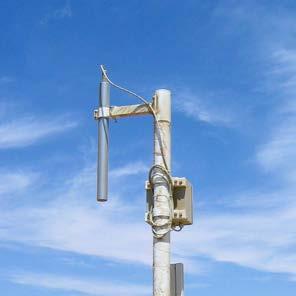
10 IMS4 LLWAS Low Level Windshear Alert System UCAR Phase-3 LLWAS algorithm compliance Turn-key delivery from site survey and engineering to lifetime support Multiple sensor interfaces (modem, fiber optic, wireless) Standalone system or integrated within AWOS / AWDSS Answering customers needs, MicroStep-MIS presents top-quality Low Level Windshear Alert System. The system is state of the art technology, mightily decreasing the riskiness of crucial flight phases, namely, takeoff and landing procedures. The low level windshears with a gain or a loss & microbursts have become a highly considered threat for CAT III International Airport Hubs as well as non-cat local airfields. All of these factors are targeted by the automatic, durable & reliable MicroStep-MIS LLWAS system. Field measurement system IMS4 LLWAS contains multiple at least 6 wind stations - installed near the airport. As the windshear phenomenon requires unique measurement techniques across different airports, selection of proper sites and optimization of the algorithm are a crucial issue for the site surveying teams. Therefore, MicroStep-MIS avails its most experienced teams to provide turn-key solution proposals built specially to fit customers needs and expectations. LLWAS Displays The displays of LLWAS are modified toprovide optimal ergonomic view of all relevant alerts and data and to provide all necessary functionality in the most convenient way. Site survey We provide site survey and design of the LLWAS system with respect to the: UCAR Phase III LLWAS methodology FAA (1989): Siting Guidelines for Low Level Windshear Alert System (LLWAS) Remote Facilities (FAA A, 12/4/89). Federal Aviation Authority ICAO (2005), Manual on Low-level Wind Shear. 1st edition (Doc. 9817). International Civil Aviation Organization ICAO (2011), Manual on Aeronautical Meteorological Practice. 9th edition (Doc. 8896). International Civil Aviation Organization Local regulations IMS4 LLWAS Server Standard COTS server or a dual hot failover cluster, the IMS4 LLWAS server collects measurements, performs the validations and recalculations, runs the algorithm to detect the windshear, generates the alerts and distributes data and alerts to displays and 3rd party systems. Additionally, a more complex integration of LLWAS with IMS4 AWOS system is available bringing even more comprehensive, relevant, and highly useful data to the airport team allowing them to significantly decrease the risk of a sudden disaster. 10


 Camera Additional soil moisture in 3 depths of 5, 10 and 20 cm Soil temperature in 3 depths of 5, 10 and 20 cm")


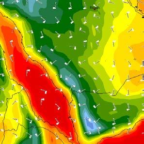
11 IMS4 Fog Prediction Fog Monitoring Fog Forecasting Measuring stations are of great importance: firstly, they provide real-time data for operative modeling, secondly, they are used in machine learning of data mining models, and finally, they provide instant data for decision-making. In addition to airport meteorological station, there can be one or more local stations, which cover the area around airport and can serve for other purposes also (e.g. road service). The measured parameters are: Temperature at a height of 2 m Humidity at a height of 2 m Wind at a height of 4 m Pressure Horizontal visibility at a height of 2.5 m (forward scatter) Camera Additional soil moisture in 3 depths of 5, 10 and 20 cm Soil temperature in 3 depths of 5, 10 and 20 cm All the data are available frequently, every 2 minutes, except of the data from camera. Images from the camera provide additional visual information for users of sensor data. It is proven useful for the verification of visibility conditions. The IMS4 Model Suite is a composition of the modern models and technologies which run in both operative and research modes. The fog prediction is the product of the IMS4 Model Suite models and tools: 3D regional weather prediction model (NWP: LAM) produces high resolution weather data (~1 km) 1D fog prediction model calculates the fog forecast based on high resolution weather data (nowcasting and short term forecasting) Data mining models option adaptively improves results by learning from previous situations (advanced statistical post processing) Satellite images are helpful for our manned fog nowcasting service. 11

12 Weather Prediction The IMS Model Suite is a composition of modern models and technologies developed by MicroStep-MIS and other reputable vendors, tuned to run together flawlessly in both operative and research modes. IMS Model Suite is an integrated, easy to use, yet powerful, system of modeling that runs on high performance hardware. The suite includes both processing and visualization tools. Models Regional weather prediction model Fog prediction model (nowcasting and short term forecasting) Lagrangian trajectory model Dust dispersion module Radioactivity dispersion module Nuclear Accident Consequence Assessment Module Volcanic ash and gases dispersion module Statistical and neural networks models (data mining) Wave model Road and runway condition model Nowcasting model Operative and research verification module Services Installation of full system at customer premises Running at MicroStep-MIS, with output delivery to customer Consultancy and studies (climate downscaling) Training Highlights We offer complete customer services, including longterm verification and customization of the model for local conditions, on-line support and training. Our system is already used within complex warning systems. 12


13 Aero CLDB Aeronautical Climatological Database Based on cutting edge technologies Scalability up to thousands of stations and variables Component-based software design Extensible to dual architecture with replicated server or cluster Compatible with MS Office, Windows, Linux Using ODBC interface CLDB fulfills WMO outlined criteria for new climatological RDBMS (new generation of Relational Database Management Systems) Aerodrome climatological summaries: For planning of aerodrome operations Indicate probability of occurrence of low visibility, low cloud base etc. throughout the year and for a specific hours of a day Basic ICAO/WMO prescribed forms: Frequencies of the occurrence of RVR/visibility and/or height of lowest cloud base of BKN or OVC extent below specified values at specified times Frequencies of visibility below specified values at specified times Frequencies of the height of the base of the lowest cloud layer of BKN or OVC extent below specified values at specified times Frequencies of occurrence of concurrent wind direction (in 30 degrees sectors) and speed within specified ranges Frequencies of surface temperature (screen) in specified ranges of 5 degrees Celsius at specified times Applications Select Reports Manual Data Entry Thermodynamical diagram Wind Rose DB Manager Web Interface Image Viewer Import of historical data 13


14 MMR Mini Meteorological Radar Unique and portable Large amount of functionality integrated in a small device Real time insight to weather situation Up to 200 km range MMR answers the increasing demand for water management tools and hazardous meteorological phenomena detection. Watersheds management, global warming adaptation strategies, flood protection, operative weather forecast, military and civil defense actions or aviation safety are supported by this radar. Moreover, tourism, media, transport and agriculture also benefit from MMR product. 14


15 IMS4 AWDSS Aviation Weather Decision Support System Detection, nowcast and forecast of phenomena affecting the airport operation Data integration from multiple sources Detection and nowcasting algo rithms and forecasting models: Thunderstorm Low level windshear and microburst Gust fronts Turbulence Fog NWP models In order to provide the air traffic controllers and meteorologists with accurate operational information IMS4 AWDSS processes the real-time data from various sources: local AWOS, ARWIS and LLWAS systems, weather radars, surface observations from the WMO / ICAO exchange networks, meteorological satellites, profiles and others. Having employed the state-of-the-art algorithms and models, the system evaluates the general situation, airport specific and runway oriented alerts, using the color status signalization to visualize the hazards, if any. The combined information will enable various users at the airport to have access to all relevant information needed for tactical decision support during the flight phases: Take off Departure Metering/descent Final approach Landing IMS4 AWDSS IT Infrastructure Depending on the system configuration, the IMS4 AWDSS could run on several Linux duplicated servers dedicated to data acquisition and communication, servers running the models and algorithms and web/presentation, or installed in a private cloud environment. 15


16 Pilot Briefing ARWIS RVR Meteorological Radar LLWAS Automated Weather Observation System ATIS/VOLMET Fog Prediction Weather Prediction Briefing & Forecasting Workstation Aviation Weather Decision Support System com
Aviation. Solutions for the real world
 Aviation RVR ARWIS LLWAS Fog Prediction Automated Weather Observation System Aviation Weather Decision Support Briefing & Forecasting Workstation Pilot Briefing Weather Prediction ATIS/VOLMET Solutions
IMS4 AWOS. Automated Weather Observation System. Integrates all airport weather data
 Integrates all airport weather data IMS4 AWOS FEATURES: Integrates all airport weather data Scalable up to ICAO category CAT III Conforms to the ICAO and WMO regulations and recommendations AWOS data on
IMS4 ARWIS. Airport Runway Weather Information System. Real-time data, forecasts and early warnings
 Airport Runway Weather Information System Real-time data, forecasts and early warnings Airport Runway Weather Information System FEATURES: Detection and prediction of runway conditions Alarms on hazardous
AWOS. Automated Weather Observing Systems COASTAL
 AWOS Automated Weather Observing Systems COASTAL Environmental Systems Monitor Monitor Your Your World World Coastal s Experience & Expertise Since 1981, Coastal Environmental Systems, Inc. (Coastal) has
Vaisala AviMet Automated Weather Observing System
 Vaisala AviMet Automated Weather Observing System Solutions to meet your challenges Our mission: to help you operate succesfully Safe, economical, reliable and flexible operation of your airport is ensured
MetConsole AWOS. (Automated Weather Observation System) Make the most of your energy SM
 Make the most of your energy SM") MetConsole AWOS (Automated Weather Observation System) Meets your aviation weather needs with inherent flexibility, proven reliability Make the most of your energy SM Automated Weather Observation System
MetConsole AWOS (Automated Weather Observation System) Meets your aviation weather needs with inherent flexibility, proven reliability Make the most of your energy SM Automated Weather Observation System
Guidance on Aeronautical Meteorological Observer Competency Standards
 Guidance on Aeronautical Meteorological Observer Competency Standards The following guidance is supplementary to the AMP competency Standards endorsed by Cg-16 in Geneva in May 2011. Format of the Descriptions
Implementation Guidance of Aeronautical Meteorological Observer Competency Standards
 Implementation Guidance of Aeronautical Meteorological Observer Competency Standards The following guidance is supplementary to the AMP competency Standards endorsed by Cg-16 in Geneva in May 2011. Please
Regional Hazardous Weather Advisory Centres (RHWACs)
") Regional Hazardous Weather Advisory Centres (RHWACs) The following outlines the criteria for the selection of RHWACs based on operational and functional requirements 1. Basic Principles The RHWAC must:
Regional Hazardous Weather Advisory Centres (RHWACs) The following outlines the criteria for the selection of RHWACs based on operational and functional requirements 1. Basic Principles The RHWAC must:
MetConsole LLWAS (Low Level Wind Shear Alert System)
") MetConsole LLWAS (Low Level Wind Shear Alert System) Enhancing aircraft safety under wind shear conditions Make the most of your energy SM MetConsole Low Level Wind Shear Alert System The Schneider Electric
MetConsole LLWAS (Low Level Wind Shear Alert System) Enhancing aircraft safety under wind shear conditions Make the most of your energy SM MetConsole Low Level Wind Shear Alert System The Schneider Electric
GEN 3.5 METEOROLOGICAL SERVICES
 GEN-3.5-1 3.5.1 RESPONSIBLE SERVICE GEN 3.5 METEOROLOGICAL SERVICES The authority entrusted with the provision of aeronautical meteorological service is the Lithuanian Hydrometeorological Service. Lithuanian
Regional Hazardous Weather Advisory Centres (RHWACs)
") Regional Hazardous Weather Advisory Centres (RHWACs) The following outlines the criteria for the selection of RHWACs based on operational and functional requirements 1. Basic Principles The RHWAC must:
Regional Hazardous Weather Advisory Centres (RHWACs) The following outlines the criteria for the selection of RHWACs based on operational and functional requirements 1. Basic Principles The RHWAC must:
Deutscher Wetterdienst
 WakeNet3-Greenwake Workshop Wake Vortex & Wind Monitoring Sensors in all weather conditions DWD s new Remote Wind Sensing Equipment for an Integrated Terminal Weather System (ITWS) Frank Lehrnickel Project
NINTH MEETING DISPLAY IN ATS UNITS. (Presented SUMMARY
 AMOFSG/9-SN No. 26 12/8/11 AERODROME METEOROLOGICAL OBSERVATION AND FORECAST STUDY GROUP (AMOFSG) NINTH MEETING Montréal, 26 to 30 September 2011 Agenda Item 6: MET informationn to support ATM UPDATING
A SMART SYSTEM FRAMEWORK ENABLING AN INNOVATIVE WEATHER AWARENESS SYSTEM FOR AIRPORTS AND BEYOND
 A SMART SYSTEM FRAMEWORK ENABLING AN INNOVATIVE WEATHER AWARENESS SYSTEM FOR AIRPORTS AND BEYOND Christian Schiefer, Sebastian Kauczok, Andre Weipert WSN16 WMO WWRP 4th International Symposium on Nowcasting
Improvement of ASECNA nowcasting and MET services through SAAPI solution
 Loïc Le Gallou, MFI Thomas Sobakam, ASECNA Saly, Senegal, November 28 th, 2018 Improvement of ASECNA nowcasting and MET services through SAAPI solution SUMMARY 1. About SAAPI Project : needs and solution
Montréal, 7 to 18 July 2014
 INTERNATIONAL CIVIL AVIATION ORGANIZATION WORLD METEOROLOGICAL ORGANIZATION 6/5/14 Meteorology (MET) Divisional Meeting (2014) Commission for Aeronautical Meteorology Fifteenth Session Montréal, 7 to 18
The current status, functions, challenges and needs of South Sudan Meteorological Department (SSMD)
") The current status, functions, challenges and needs of South Sudan Meteorological Department (SSMD) Presented: by Mojwok Ogawi Modo, South Sudan Meteorological Department. Background The present SSMD was
The current status, functions, challenges and needs of South Sudan Meteorological Department (SSMD) Presented: by Mojwok Ogawi Modo, South Sudan Meteorological Department. Background The present SSMD was
GEN 3.5 METEOROLOGICAL SERVICES
 AIP GEN 3.5-1 GEN 3.5 METEOROLOGICAL SERVICES 1. RESPONSIBLE SERVICE The meteorological services for civil aviation at Jordan are provided by the Jordanian Meteorological Department. Postal Address: Director
Road Weather Information Systems
 Road & weather data, forecasting, early warnings Road Weather Information System FEATURES: Road Weather Stations System description The measurement module offers: Interfaces for the various sensors and
Civil Aviation Authority of Nepal
 Civil Aviation Requirements For Meteorological Service for International Air Navigation CAR 3 First Edition - July, 2017 Civil Aviation Authority of Nepal Amendments Amendments and Corrigenda to these
Implementation Guidance of Aeronautical Meteorological Forecaster Competency Standards
 Implementation Guidance of Aeronautical Meteorological Forecaster Competency Standards The following guidance is supplementary to the AMP competency Standards endorsed by Cg-16 in Geneva in May 2011. Implicit
SEYCHELLES TECHNICAL STANDARDS
 SEYCHELLES TECHNICAL STANDARDS Aviation Meteorological Standards Seychelles Technical Standards Aviation Meteorological Standards Issue 01 July 2017 CONTENTS (general layout) FOREWORD Aviation Meteorological
CIVIL AVIATION REQUIREMENTS SECTION 9 AIR SPACE AND AIR TRAFFIC MANAGEMENT. ISSUE II 24 th March, 2017 F. NO. AV.27077/1/2010-ANS
 GOVERNMENT OF INDIA OFFICE OF THE DIRECTOR GENERAL OF CIVIL AVIATION TECHNICAL CENTRE, OPP SAFDURJUNG AIRPORT, NEW DELHI CIVIL AVIATION REQUIREMENTS SECTION 9 AIR SPACE AND AIR TRAFFIC MANAGEMENT SERIES
Checklist Templates for Direct Observation and Oral Assessments (AMOB)
") Checklist Templates for Direct Observation and Oral Assessments (AMOB) Competency Assessment System Hong Kong Observatory Hong Kong, China Prepared By: Signed Approved By: Signed Date: 20/08/2012 Date:
Checklist Templates for Direct Observation and Oral Assessments (AMOB) Competency Assessment System Hong Kong Observatory Hong Kong, China Prepared By: Signed Approved By: Signed Date: 20/08/2012 Date:
Enhancing The Delivery Of Weather & Climate Information To End-Users. by Meteorological Services Division, NEA, Singapore
 Enhancing The Delivery Of Weather & Climate Information To End-Users by Meteorological Services Division, NEA, Singapore WMO RA V Seminar on Enhancing Service Delivery Kuala Lumpur, Malaysia, 2-6 April
First MAWS Shipped to France for CNES
 First MAWS Shipped to France for CNES The first MAWS weather station shipped to France for CNES (Comission Nationale d Etudes Spatiales), the French Space Agency, has been used by the Stratospheric Balloons
Calculates CAT and MWT diagnostics. Paired down choice of diagnostics (reduce diagnostic redundancy) Statically weighted for all forecast hours
 Statically weighted for all forecast hours") 1 Major Upgrades All diagnostics mapped to Eddy Dissipation Rate ADDS now displays EDR values CAT diagnostic extended down to 1000 feet MSL & forecast hours 15 and 18 New Mountain Wave diagnostic CAT diagnostics
1 Major Upgrades All diagnostics mapped to Eddy Dissipation Rate ADDS now displays EDR values CAT diagnostic extended down to 1000 feet MSL & forecast hours 15 and 18 New Mountain Wave diagnostic CAT diagnostics
Lightning Safety in a Flash / VAISALA AIRPORT LIGHTNING INFORMATION SYSTEM (ALIS)
") Lightning Safety in a Flash / VAISALA AIRPORT LIGHTNING INFORMATION SYSTEM (ALIS) Global Threat to Airports Proven. Global. The Vaisala Airport Lightning Information System (ALIS) opens a new era of universal
Lightning Safety in a Flash / VAISALA AIRPORT LIGHTNING INFORMATION SYSTEM (ALIS) Global Threat to Airports Proven. Global. The Vaisala Airport Lightning Information System (ALIS) opens a new era of universal
1 Introduction. Station Type No. Synoptic/GTS 17 Principal 172 Ordinary 546 Precipitation
 Use of Automatic Weather Stations in Ethiopia Dula Shanko National Meteorological Agency(NMA), Addis Ababa, Ethiopia Phone: +251116639662, Mob +251911208024 Fax +251116625292, Email: Du_shanko@yahoo.com
Unique Vaisala Global Lightning Dataset GLD360 TM
 Unique Vaisala Global Lightning Dataset GLD360 TM / THE ONLY LIGHTNING DETECTION NETWORK CAPABLE OF DELIVERING HIGH-QUALITY DATA ANYWHERE IN THE WORLD GLD360 provides high-quality lightning data anywhere
Unique Vaisala Global Lightning Dataset GLD360 TM
 Unique Vaisala Global Lightning Dataset GLD360 TM / THE ONLY LIGHTNING DETECTION NETWORK CAPABLE OF DELIVERING SUCH HIGH-QUALITY DATA ANYWHERE IN THE WORLD GLD360 provides high-quality lightning data anywhere
Opportunities and Risks National Responses Austria Aeronautical MET Services -Part of an ATC Provider
 Opportunities and Risks National Responses Austria Aeronautical MET Services -Part of an ATC Provider AUSTRO CONTROL is the former Federal Office of Civil Aviation. is a company with limited liability.
NATION WIDE METEOROLOGICAL NETWORK
 NATION WIDE METEOROLOGICAL NETWORK Foeke Kuik (1) Clarisa Martínez (2) (1) Telvent Netherlands, Landzichtweg 70, 4105 DP Culemborg, The Netherlands, foeke.kuik@telvent.abengoa.com, (2) Telvent Energía
Technical Regulations
 Technical Regulations Basic Documents No. 2 Volume II Meteorological Service for International Air Navigation 2013 edition WMO-No. 49 Technical Regulations Basic Documents No. 2 Volume II Meteorological
(Country Report) Saudi Arabia
 Saudi Arabia") The 5th Meeting of the Coordinating Group of the RA II WIGOS Satellite Project 21 October, Vladivostok city, Russky Island, Russia Far Eastern Federal University (Country Report) Saudi Arabia General Authority
The 5th Meeting of the Coordinating Group of the RA II WIGOS Satellite Project 21 October, Vladivostok city, Russky Island, Russia Far Eastern Federal University (Country Report) Saudi Arabia General Authority
INCA-CE achievements and status
 INCA-CE achievements and status Franziska Strauss Yong Wang Alexander Kann Benedikt Bica Ingo Meirold-Mautner INCA Central Europe Integrated nowcasting for the Central European area This project is implemented
CLIMATE CHANGE ADAPTATION BY MEANS OF PUBLIC PRIVATE PARTNERSHIP TO ESTABLISH EARLY WARNING SYSTEM
 CLIMATE CHANGE ADAPTATION BY MEANS OF PUBLIC PRIVATE PARTNERSHIP TO ESTABLISH EARLY WARNING SYSTEM By: Dr Mamadou Lamine BAH, National Director Direction Nationale de la Meteorologie (DNM), Guinea President,
Evolving Meteorological Services for the Terminal Area
 Evolving Meteorological Services for the Terminal Area Towards an new participatory approach in ATM H. Puempel Chief, Aeronautical Meteorology Division Weather and Disaster Risk Reduction Dept. WMO The
USE OF GROUND BASED WEATHER RADAR DATA IN AIR TRAFFIC MANAGEMENT PROCEDURES
 USE OF GROUND BASED WEATHER RADAR DATA IN AIR TRAFFIC MANAGEMENT PROCEDURES EUROCONTROL Workshop on MET support to ATM Brussels, 27 th -28 th May 2009 Dr. Marco Tadini Head, Planning and Development Meteorology
SOFTWARE. Control of the AMS SYSTEM CONTROL AND MONITORING OF AIRFIELD GROUND LIGHTING EQUIPMENT
 Control of the AMS SYSTEM SOFTWARE CONTROL AND MONITORING OF AIRFIELD GROUND LIGHTING EQUIPMENT Description of function airfield ground lighting equipment are shown on the screen representing the airport
FLYSAFE meteorological hazard nowcasting driven by the needs of the pilot
 FLYSAFE meteorological hazard nowcasting driven by the needs of the pilot R. W. Lunnon, Met Office, Exeter, EX1 3PB, United Kingdom., Thomas Hauf, Thomas Gerz, and Patrick Josse. 1. Introduction The FLYSAFE
Volcanic Ash Guidance Material Docs. 9766, 9691 and 9974
 International Civil Aviation Organization Raul Romero ICAO IAVWOPSG Secretary 2 Section 1 Scientific background Chapter 1. Volcanic eruptions 1.1 Classification 1.2 Mechanism of volcanic eruptions 1.3
CAS & CAeM Aviation Research and Demonstration Project Paris-CDG airport
 World Meteorological Organization Working together in weather, climate and water WMO CAS & CAeM Aviation Research and Demonstration Project Paris-CDG airport WMO www.wmo.int Paris-CDG airport Mid-latitude
WWRP Implementation Plan Reporting AvRDP
 WWRP Implementation Plan Reporting AvRDP Please send you report to Paolo Ruti (pruti@wmo.int) and Sarah Jones (sarah.jones@dwd.de). High Impact Weather and its socio economic effects in the context of
WORLD AREA FORECAST SYSTEM OPERATIONS GROUP (WAFSOPSG)
") International Civil Aviation Organization WAFSOPSG/7-WP/10 5/7/12 WORKING PAPER WORLD AREA FORECAST SYSTEM OPERATIONS GROUP (WAFSOPSG) SEVENTH MEETING Lima, Peru, 17 to 21 September 2012 Agenda Item 6:
International Civil Aviation Organization WAFSOPSG/7-WP/10 5/7/12 WORKING PAPER WORLD AREA FORECAST SYSTEM OPERATIONS GROUP (WAFSOPSG) SEVENTH MEETING Lima, Peru, 17 to 21 September 2012 Agenda Item 6:
Plan for operational nowcasting system implementation in Pulkovo airport (St. Petersburg, Russia)
") Plan for operational nowcasting system implementation in Pulkovo airport (St. Petersburg, Russia) Pulkovo airport (St. Petersburg, Russia) is one of the biggest airports in the Russian Federation (150
Plan for operational nowcasting system implementation in Pulkovo airport (St. Petersburg, Russia) Pulkovo airport (St. Petersburg, Russia) is one of the biggest airports in the Russian Federation (150
METEOROLOGY PANEL (METP) WORKING GROUP- METEOROLOGICAL OPERATION GROUP (MOG) FIRST MEETING
 WORKING GROUP- METEOROLOGICAL OPERATION GROUP (MOG) FIRST MEETING") 8 28/7/15 METEOROLOGY PANEL (METP) WORKING GROUP- METEOROLOGICAL OPERATION GROUP (MOG) FIRST MEETING Gatwick, United Kingdom, 08 to 11 September 2015 Agenda Item 3: Matters relating to SADIS 3.3: Operations
8 28/7/15 METEOROLOGY PANEL (METP) WORKING GROUP- METEOROLOGICAL OPERATION GROUP (MOG) FIRST MEETING Gatwick, United Kingdom, 08 to 11 September 2015 Agenda Item 3: Matters relating to SADIS 3.3: Operations
Doppler Weather Radars and Weather Decision Support for DP Vessels
 Author s Name Name of the Paper Session DYNAMIC POSITIONING CONFERENCE October 14-15, 2014 RISK SESSION Doppler Weather Radars and By Michael D. Eilts and Mike Arellano Weather Decision Technologies, Inc.
TONGA COUNTRY REPORT. Officer : John Holi
 TONGA COUNTRY REPORT Officer : John Holi OUTLINES INTRODUCTION BACKGROUND INFORMATION CLIMATE TONGA METEOROLOGICAL SERVICE PROPOSAL INTRODUCTION Location of Tonga Lies between 15 173 W 155 177 W 25.55
Primary author: Tymvios, Filippos (CMS - Cyprus Meteorological Service, Dpt. of Aeronautical Meteorology),
,") Primary author: Tymvios, Filippos (CMS - Cyprus Meteorological Service, Dpt. of Aeronautical Meteorology), ftymvios@ms.moa.gov.cy Co-author: Marios Theophilou (Cyprus Meteorological Service, Climatology
Primary author: Tymvios, Filippos (CMS - Cyprus Meteorological Service, Dpt. of Aeronautical Meteorology), ftymvios@ms.moa.gov.cy Co-author: Marios Theophilou (Cyprus Meteorological Service, Climatology
Moroccan lightning detection network, topology, performance and management of the network
 Moroccan lightning detection network, topology, performance and management of the network Mohamed DAHOUI, Mohamed NBOU and Rabia MERROUCHI Moroccan Meteorological Center Tel (212)71302837, Fax: (212)22908593
Meteorological Service for International Air Navigation
 International Standards and Recommended Practices Annex 3 to the Convention on International Civil Aviation Meteorological Service for International Air Navigation Part I Core SARPs Part II Appendices
Road weather forecasts and MDSS in Slovakia
 ID: 0030 Road weather forecasts and MDSS in Slovakia M. Benko Slovak Hydrometeorological Institute (SHMI), Jeséniova 17, 83315 Bratislava, Slovakia Corresponding author s E-mail: martin.benko@shmu.sk ABSTRACT
Meteorological Service for International Air Navigation
 International Standards and Recommended Practices Annex 3 to the Convention on International Civil Aviation Meteorological Service for International Air Navigation Part I Core SARPs Part II Appendices
SCOPE: Outlines standard techniques for setting up and conducting voice communication and broadcasting ATIS at Hong Kong VACC
 STANDARD OPERATING PROCEDURE (SOP) DOCUMENT NUMBER: HKVACC-SOP011-R5 DATE ISSUED: 1 APR 2015 REVISION: 5 SUBJECT: Voice Communication Setup and ATIS Guide EFFECTIVE DATE: 5 AUG 2018 SCOPE: Outlines standard
WAFS_Word. 2. Menu. 2.1 Untitled Slide
 WAFS_Word 2. Menu 2.1 Untitled Slide Published by Articulate Storyline 1. Introduction 1.1 Introduction Notes: As you will probably be aware, the traditional significant weather forecasts, usually seen
Annex I to Resolution 6.2/2 (Cg-XVI) Approved Text to replace Chapter B.4 of WMO Technical Regulations (WMO-No. 49), Vol. I
 Approved Text to replace Chapter B.4 of WMO Technical Regulations (WMO-No. 49), Vol. I") Annex I to Resolution 6.2/2 (Cg-XVI) Approved Text to replace Chapter B.4 of WMO Technical Regulations (WMO-No. 49), Vol. I TECHNICAL REGULATIONS VOLUME I General Meteorological Standards and Recommended
Annex I to Resolution 6.2/2 (Cg-XVI) Approved Text to replace Chapter B.4 of WMO Technical Regulations (WMO-No. 49), Vol. I TECHNICAL REGULATIONS VOLUME I General Meteorological Standards and Recommended
INCA CE: Integrating Nowcasting with crisis management and risk prevention in a transnational framework
 INCA CE: Integrating Nowcasting with crisis management and risk prevention in a transnational framework Yong Wang ZAMG, Austria This project is implemented through the CENTRAL EUROPE Programme co-financed
GREAT EXPERIENCE IN MONITORING SYSTEMS CAPACITY ON DEVELOPMENT AND CREATING SOLUTIONS ADVANCED ITALIAN TECHNOLOGY
 GREAT EXPERIENCE IN MONITORING SYSTEMS CAPACITY ON DEVELOPMENT AND CREATING SOLUTIONS ADVANCED ITALIAN TECHNOLOGY NESA Srl Via Sartori 6/8 31020 Vidor (TV) Italy www.nesasrl.it info@nesasrl.it Quality
SCOPE: Outlines standard techniques for setting up and conducting voice communication and broadcasting ATIS at Hong Kong VACC
 STANDARD OPERATING PROCEDURE (SOP) DOCUMENT NUMBER: HKVACC-SOP011-R5 DATE ISSUED: 1 APR 2015 REVISION: 5 SUBJECT: Voice Communication Setup and ATIS Guide EFFECTIVE DATE: 5 AUG 2018 SCOPE: Outlines standard
Visibility and present weather sensors. you can trust... visibly better
 Visibility and present weather sensors you can trust... Biral HSS sensors visibly better CONTENTS HSS Application Examples PAGE 2 (this page) APPLICATION EXAMPLES 1 (Highway and Research) TRACK RECORD
Meteorological CLEAR BUT PRESENT DANGER
 THE INTERNATIONAL REVIEW OF WEATHER, CLIMATE, AND HYDROLOGY TECHNOLOGIES AND SERVICES Meteorological AUGUST 2012 T E C H N O L O G Y I N T E R N A T I O N A L CLEAR BUT PRESENT DANGER The latest Earth
Montréal, 7 to 18 July 2014
 INTERNATIONAL CIVIL AVIATION ORGANIZATION WORLD METEOROLOGICAL ORGANIZATION MET/14-WP/34 28/5/14 Meteorology (MET) Divisional Meeting (2014) Commission for Aeronautical Meteorology Fifteenth Session Montréal,
WMO Aeronautical Meteorology Scientific Conference 2017
 Session 1 Science underpinning meteorological observations, forecasts, advisories and warnings 1.6 Observation, nowcast and forecast of future needs 1.6.2 Seamless nowcast and numerical weather prediction,
Use of lightning data to improve observations for aeronautical activities
 Use of lightning data to improve observations for aeronautical activities Françoise Honoré Jean-Marc Yvagnes Patrick Thomas Météo_France Toulouse France I Introduction Aeronautical activities are very
Workstations at Met Éireann. Kieran Commins Head Applications Development
 Workstations at Met Éireann Kieran Commins Head Applications Development Background For many years Met Éireann has used several systems for visualisation of data X-charts for NWP Intranet for Satellite/radar
Aeronautical Information Service
 , St. Maarten and The Netherlands EFFECTIVE DATE: 31 MARCH 2016 KNMI Meteorological Services Information for TNCB, TNCE and TNCS Page: GEN 2.7-1 Sunrise / sunset tables 1. The tables on the following pages
Integrating Nowcastingwith crisis management and risk prevention in a transnational framework (INCA-CE)
") Integrating Nowcastingwith crisis management and risk prevention in a transnational framework (INCA-CE) Yong Wang ZAMG, Austria This project is implemented through the CENTRAL EUROPE Programme co-financed
Integrating Nowcastingwith crisis management and risk prevention in a transnational framework (INCA-CE) Yong Wang ZAMG, Austria This project is implemented through the CENTRAL EUROPE Programme co-financed
Service improvement through integration of AIM, MET and ATM Information Services
 Service improvement through integration of AIM, MET and ATM Information Services B0-DATM EANPG COG AIM Task Force implementation practice Dr. Vadims Tumarkins Chairman of the EANPG COG AIM Task Force Head
<Operational nowcasting systems in the framework of the 4-D MeteoCube>
 Background Nowcasting is applicable
AERODROME METEOROLOGICAL OBSERVATION AND FORECAST STUDY GROUP (AMOFSG)
") AMOFSG/10-IP/4 21/5/13 AERODROME METEOROLOGICAL OBSERVATION AND FORECAST STUDY GROUP (AMOFSG) TENTH MEETING Montréal, 17 to 19 June 2013 Agenda Item 5: Aerodrome observations AUTOMATED CLOUD INFORMATION
AMOFSG/10-IP/4 21/5/13 AERODROME METEOROLOGICAL OBSERVATION AND FORECAST STUDY GROUP (AMOFSG) TENTH MEETING Montréal, 17 to 19 June 2013 Agenda Item 5: Aerodrome observations AUTOMATED CLOUD INFORMATION
Flight Dispatcher Aviation Meteorology Required Knowledge
 Flight Dispatcher Aviation Meteorology Required Knowledge 3.1 THE EARTH'S ATMOSPHERE 1 Properties 2 Vertical Structure 3 ICAO Standard Atmosphere 3.2 ATMOSPHERIC PRESSURE 1 Pressure Measurements 2 Station
Complete Weather Intelligence for Public Safety from DTN
 Complete Weather Intelligence for Public Safety from DTN September 2017 White Paper www.dtn.com / 1.800.610.0777 From flooding to tornados to severe winter storms, the threats to public safety from weather-related
the issue of for Aviation
 2/3/12 INTERNATIONAL VOLCANIC ASH TASK FORCE (IVATF) SECOND MEETING Montréal, 11 to 15 July 2011 List of Recommendations The second meeting of the International Volcanic Ash Task Force (IVATF/2), held
Your Source for Global Aviation Forecasts
 Your Source for Global Aviation Forecasts (831) 238-5054 100 Sky Park Drive Monterey, CA 93940 Weather4Cast.com Live Weather Data Feeds Weather4Cast.com provides Live Aviation Weather Data Feeds formatted
International Civil Aviation Organization THIRD MEETING OF THE METEOROLOGICAL REQUIREMENTS TASK FORCE (MET/R TF/3)
") MET/R TF/3 IP/02 International Civil Aviation Organization THIRD MEETING OF THE METEOROLOGICAL REQUIREMENTS TASK FORCE (MET/R TF/3) 28 29 November 2013, Bangkok, Thailand Agenda Item 3a: Current and future
MET/R TF/3 IP/02 International Civil Aviation Organization THIRD MEETING OF THE METEOROLOGICAL REQUIREMENTS TASK FORCE (MET/R TF/3) 28 29 November 2013, Bangkok, Thailand Agenda Item 3a: Current and future
TRINIDAD AND TOBAGO. Meeting to Enhance State Coordination. MET, AIM, and ATM Fields PRESENTED BY. Between. (Mexico City, Mexico, July 2016)
") TRINIDAD AND TOBAGO Meeting to Enhance State Coordination Between MET, AIM, and ATM Fields (Mexico City, Mexico, 26 28 July 2016) PRESENTED BY Robert Rooplal, ATM Officer Ricky Bissessar, AIM Officer PIARCO
TRINIDAD AND TOBAGO Meeting to Enhance State Coordination Between MET, AIM, and ATM Fields (Mexico City, Mexico, 26 28 July 2016) PRESENTED BY Robert Rooplal, ATM Officer Ricky Bissessar, AIM Officer PIARCO
DESIGNED FOR EASY INTEGRATION HOW TO GET STARTED. Global Data Products
 DESIGNED FOR EASY INTEGRATION The easy-to-implement Baron Weather API allows precision aviation weather information to be added to any of your websites, apps or software. Backed by extensive documentation
FREEZING CONTAMINATION : AIRCRAFT ICING
 FREEZING CONTAMINATION : AIRCRAFT ICING PUTTING THE FORECASTS IN PLACE A transmission chain of adapted information SIGMET, AIRMET, GAMET, SIGWX charts PIREPS Awareness of the icing phenomena A few points
New Meteorological Services Supporting ATM
 New Meteorological Services Supporting ATM Meteorological Services in the Terminal Area (MSTA)...providing MET services to support a move from Air Traffic Control (ATC) to more integrated and collaborative
Nicolas Duchene 1, James Smith 1 and Ian Fuller 2
 A METHODOLOGY FOR THE CREATION OF METEOROLOGICAL DATASETS FOR LOCAL AIR QUALITY MODELLING AT AIRPORTS Nicolas Duchene 1, James Smith 1 and Ian Fuller 2 1 ENVISA, Paris, France 2 EUROCONTROL Experimental
METEOROLOGICAL WARNINGS STUDY GROUP (METWSG)
") METWSG/4-SN No. 6 12/3/12 METEOROLOGICAL WARNINGS STUDY GROUP (METWSG) FOURTH MEETING Montréal, 15 to 18 May 2012 Agenda Item 6: Wind shear, turbulence and tsunami warnings TSUNAMI INFORMATION (Presented
METWSG/4-SN No. 6 12/3/12 METEOROLOGICAL WARNINGS STUDY GROUP (METWSG) FOURTH MEETING Montréal, 15 to 18 May 2012 Agenda Item 6: Wind shear, turbulence and tsunami warnings TSUNAMI INFORMATION (Presented
ROAD WEATHER INFORMATION SYSTEM DEVICE TESTING LEVEL C
 Page 1 of 11 Date: Jan. 05, 2009 This procedure outlines Level C device test to be performed on Road Weather Information System. Level C device testing demonstrates that each device is fully operational
CAP 437 Offshore Meteorological Observer Training
 CAP 437 Offshore Meteorological Observer Training Training for Meteorological Observers in support of Offshore Helicopter Operations CAP 437 Offshore Meteorological Observer Training Page 1 Meteorological
Notice of Proposed Amendment (E) Requirements for ATM/ANS providers and the safety oversight thereof
 Requirements for ATM/ANS providers and the safety oversight thereof") European Aviation Safety Agency Rulemaking Directorate Notice of Proposed Amendment 2013-08 (E) Requirements for ATM/ANS providers and the safety oversight thereof (Appendix VII to the Explanatory Note)
European Aviation Safety Agency Rulemaking Directorate Notice of Proposed Amendment 2013-08 (E) Requirements for ATM/ANS providers and the safety oversight thereof (Appendix VII to the Explanatory Note)
Meteorological Service for International Air Navigation. Part I Core SARPs Part II Appendices and Attachments Nineteenth Edition, July 2016
 International Standards and Recommended Practices Annex 3 to the Convention on International Civil Aviation Meteorological Service for International Air Navigation Part I Core SARPs Part II Appendices
APAC GUIDELINES FOR OPERATIONAL SIGMET COORDINATION
 Introduction APAC GUIDELINES FOR OPERATIONAL SIGMET COORDINATION 1. Inconsistencies in SIGMET information issued by different Meteorological Watch Offices (MWOs) on hazardous weather phenomenon straddling
MANAGEMENT OF THE NIEMEN RIVER BASIN WITH ACCOUNT OF ADAPTATION TO CLIMATE CHANGE. Hydro-meteorological Monitoring System
 MANAGEMENT OF THE NIEMEN RIVER BASIN WITH ACCOUNT OF ADAPTATION TO CLIMATE CHANGE Hydro-meteorological Monitoring System Draft Interim Report Milestone 1 Giovanni Crema 18 October 2012 Scope of work assessment
Unit 5: NWS Hazardous Weather Products. Hazardous Weather and Flooding Preparedness
 Unit 5: NWS Hazardous Weather Products Objectives Describe the mission of the NWS Describe the basic organizational structure of the NWS Explain the purpose of various NWS products Explain how Probability
Syllabus details and associated Learning Objectives (A) and EIR METEOROLOGY
 and EIR METEOROLOGY") Syllabus details associated Learning Objectives 050 00 00 00 METEOROLOGY 050 01 00 00 THE ATMOSPHERE 050 01 02 00 Air temperature 050 01 02 04 Lapse rates LO Describe qualitatively quantitatively the temperature
Syllabus details associated Learning Objectives 050 00 00 00 METEOROLOGY 050 01 00 00 THE ATMOSPHERE 050 01 02 00 Air temperature 050 01 02 04 Lapse rates LO Describe qualitatively quantitatively the temperature
Introduction to SIGMET. 28 June 2016 Japan Meteorological Agency
 Introduction to SIGMET 28 June 2016 Japan Meteorological Agency SIGMET Definition SIGMET information Information issued by a meteorological watch office concerning the occurrence or expected occurrence
P10.3 HOMOGENEITY PROPERTIES OF RUNWAY VISIBILITY IN FOG AT CHICAGO O HARE INTERNATIONAL AIRPORT (ORD)
") P10.3 HOMOGENEITY PROPERTIES OF RUNWAY VISIBILITY IN FOG AT CHICAGO O HARE INTERNATIONAL AIRPORT (ORD) Thomas A. Seliga 1, David A. Hazen 2 and Stephen Burnley 3 1. Volpe National Transportation Systems
P10.3 HOMOGENEITY PROPERTIES OF RUNWAY VISIBILITY IN FOG AT CHICAGO O HARE INTERNATIONAL AIRPORT (ORD) Thomas A. Seliga 1, David A. Hazen 2 and Stephen Burnley 3 1. Volpe National Transportation Systems
MeteoGroup RoadMaster. The world s leading winter road weather solution
 MeteoGroup RoadMaster The world s leading winter road weather solution Discover why RoadMaster is the world s leading winter road weather solution. Managing winter road maintenance means that you carry
Field study of the latest transmissometers at Hong Kong International Airport
 Field study of the latest transmissometers at Hong Kong International Airport P. W. Chan Hong Kong Observatory 134A Nathan Road, Kowloon, Hong Kong, China Tel:+852 2926 8435, Fax: +852 2311 9448, Email:
WMO/ICAO AMF Competencies
 WMO/ICAO AMF Competencies Workshop on Aeronautical Competencies and SIGMETs August 26 st, 2015 Karine Dumas Meteorological Service of Canada Montreal Competency Hierarchy Top-level Competencies WMO 49
Weather Information for Europe 3 May 2018
 Weather Information for Europe 3 May 2018 Weatherproofing the network A collaborative approach Jaakko Nuottokari EUMETNET WG AVIMET Chair Head of Aviation and Defence Finnish Meteorological Institute Jaakko.Nuottokari@fmi.fi
CMO Terminal Aerodrome Forecast (TAF) Verification Programme (CMOTafV)
 Verification Programme (CMOTafV)") CMO Terminal Aerodrome Forecast (TAF) Verification Programme (CMOTafV) Kathy-Ann Caesar Meteorologist Caribbean Meteorological Council - 47 St. Vincent, 2007 CMOTafV TAF Verification Programme Project:
CMO Terminal Aerodrome Forecast (TAF) Verification Programme (CMOTafV) Kathy-Ann Caesar Meteorologist Caribbean Meteorological Council - 47 St. Vincent, 2007 CMOTafV TAF Verification Programme Project:
Building a Weather-Ready Nation For Aviation
 Building a Weather-Ready Nation For Aviation Laura Furgione NOAA Deputy Assistant Administrator for Weather Services Friends and Partners in Aviation Weather July 22, 2014 Case for Change Average Year
Advances in weather and climate science
 Advances in weather and climate science Second ICAO Global Air Navigation Industry Symposium (GANIS/2) 11 to 13 December 2017, Montreal, Canada GREG BROCK Scientific Officer Aeronautical Meteorology Division