Strong Motion, Damage, and Loss of Wenchuan Earthquake
|
|
|
- David King
- 5 years ago
- Views:
Transcription
1 Strong Motion, Damage, and Loss of Wenchuan Earthquake Zifa Wang Institute of Engineering Mechanics, China Earthquake Administration August 18, 2008
2 Acknowledgement This presentation uses a number of pictures and loss numbers aggregated based on the efforts of CEA field team after the earthquake, particularly from members of IEM. The numbers presented here are preliminary and the opinions expressed here are the personal ones of the presenting author and they do not necessarily reflect those of IEM and CEA.
3 Contents Historical Earthquakes in China Strong Motion Damage Response and Reconstruction Efforts Loss Estimation
4 1Historical Earthquakes in China
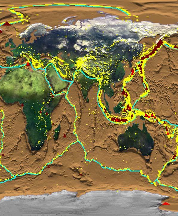


5 China is seismically active


6 The Distribution of The Distribution of China Seismic Belts China Seismic Belt The Distribution of China Seismic Belt The Distribution of China Seismic Belt
7 No Strong Earthquakes in the History of China Time Location M Death 1303 Shanxi 8 200, Tibet Shaanxi , Gansu 8 31, Shandong , Hebei 8 45, Ningxia 8 50, Xinjiang Tibet Yunnan 8 6, Gansu 8 30, Xinjiang 8.3 5, Taiwan Ningxia , Gansu 8 40, Xinjiang Tibet 8.6 3, Tibet Tangshan , Wenchuan ,000+

8 1975 Haicheng Earthquake The first successful imminent earthquake prediction in human history Public Notice There will be an earthquake very soon, the film will be shown in the open air instead of in the cinema. Xinhua Cinema

9 The 1976 Tangshan Earthquake
10 2Strong Motion
11 Earthquake Parameters Timeat , May 12, 2008 LocationWenchuan (31.0, 103.4) Magnitude8.0 (Ms) Depth19km Death69197 (July 10 th, 2008) Missing: Injury Loss: ~ 1 trillion rmb (150b usd)?

12 The Earthtquake Rupture Process (IGS)

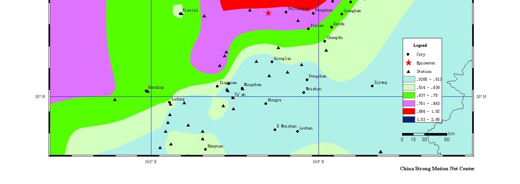
13 Newly completed strong motion observation network nationwide211 in Sichuan Provicne)
14 Stations which recorded the Wenchuan Earthquake
15 Summary of strong motion observation 398 stations, 1191 records 19 stations within 100km from the epicenter, 34 stations within km from the epicenter 12 stations within 20km from the fault, 11 within 20-50km from the fault, 22 within km from the fault; 120 records with PGA over 100gal; Closest fault distance is 0.74km at Qingping Station, with a PGA of 824.1gal Closest epicenter distance is 22.2km at Wolong, with a PGA of 956.7gal and 1.09km fault distance
16 Wolong Station (22.2km epicenter distance, 1.09 fault distance)
17 Qingping, Mianzhu Stationepicenter distance: 87.5km, fault distance: 0.74km)
18 Bajiao, Shifang City ( ~150km epicenter distance, ~75km fault distance)
19 Fourier and Power Spectrum at Bajiao, Shifang City
20 ()
21 PGA
22 PGA
23 PGA
24
25

26 PGA EW287gal EW421gal NS519gal UD357gal NS289gal EW957gal EW824gal UD633gal
27 3Damage
28 3.1 Structural Damage in a variety of forms

29 Typical damage for a brick structure

30 Damage to a dorm in Tumen Middle School in Mianzhu City

31 Tilted building toward right

32 Complete destruction to buildings in the remote villages

33 Collapse of an 8-story building in Beichuan County

34 Damage to a 2-story building in Beichuan County

35 Crushed bottom 2 stories and rotation of the building in Dujiangyan

36 Complete destruction to school buildings in Hanwang town in Mianzhu


37 Collapse of the 1 st story in a dorm building of Xuankou Middle School at Yingxiu town of Wenchuan County

38 Collapse of classroom building in Xuankou Middle School of Yingxiu Town in Wenchuan County

39 Damage to a classroom building at Jiuyuan Middle School in Dujiangyan City

40 A Standing structure in Hongbai town of Shifang

41 Minor damage to an office building for Beichuan Tea Manufacturer in Beichuan County

42 Bailuzhen Middle School in Pengzhou
43 3.2 Damage to lifelines
44 3.2.1 Damage to road and bridges

45 Damage To Road Network 14 days after the earthquake, all roads to county center were repaired. By June 14, all roads to 248 out of 254 towns were repaired.

46 Damage to a bridge in Beichuan County

47 Sliding of the bridge decks in Beichuan County

48 Collapse of Baihua Bridge toward Yingxiu

49 Damage to the roads to Yingxiu

50 Collapse of small bridges deep in the mountains near Hongbai town

51 Damage to the pillar of Huilan Bridge in Mianzhu City

52 Damage to a bridge in Mianchi Town

53 Road damage due to landslide near Yingxiu
54 3.2.2 Damage to water system
55 Damage overview Damage water plant:8426 pipeline: km By May 31 st, 4080 plants were restored, and 21876km pipeline were repaired (less than 20 days)

56 Damage to water system in Pengzhou city


57 Typical Damage types Damage to Pipe Joint Damage to PVC pipeline
58 3.2.3 Damage to electric system
59 Damage to electric system (Sichuan province) 500kV 220kV 110kV 35kV 10kV Type Total Damaged Station 18 1 Line 41 4 Station Line Station Line Station Line City net Rural net

60 Destruction to Ertaishan Station (220kV, near epicenter)
61 Restoration of partially damaged electric system (Sichuan province) By June 10, 155 out of kv or above power stations were repaired and service was restored 2607 of kv line were repaired Electricity service was fully restored
62 Restoration of partially damaged electric system (Sichuan province) Out of the 17 completely demolished stations, 220kv Anxian, 220kv Dakang, 110kv Xiaoba, 110kv Yuanmenba and 35kv Jujiaya are to be rebuilt. They are all scheduled to put into service by August 31, 2008
63 3.2.4 Damage to railroads


64 109 Damage to rails Baoji-Chengdu line 4 locations, Chengdu- Kunming line 4 locations, and Chengdu- Chongqing 7 locations Damage to Stations May 24, all major lines were repaired and service was restored Damage to Railroads

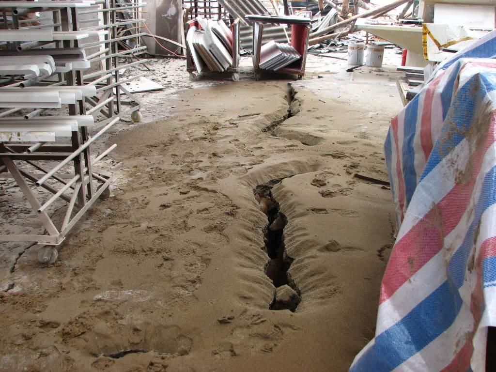
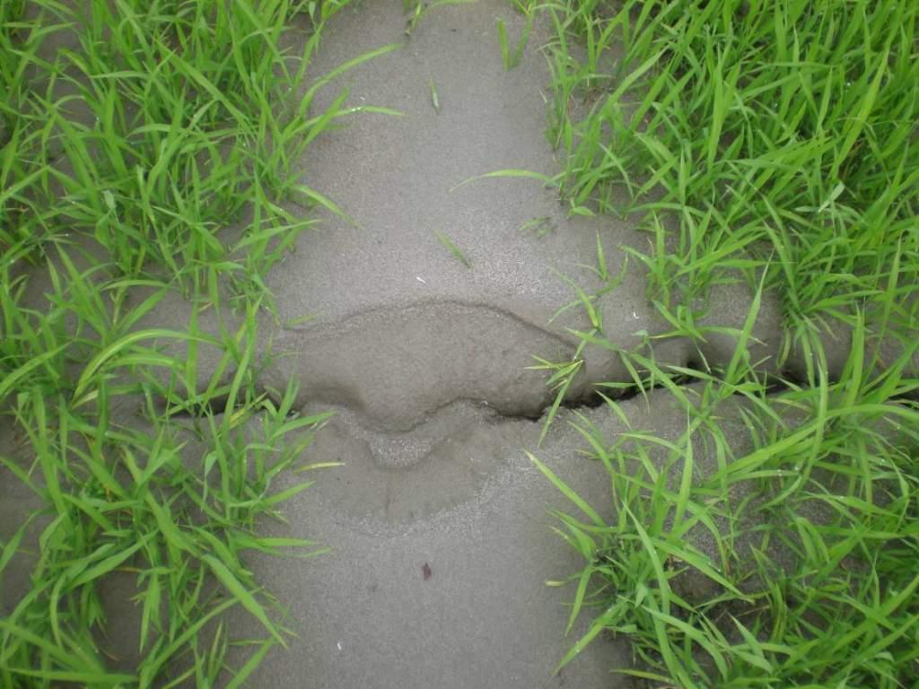
65 Damage to train tracks on a bridge near Yinghua town
")
66 Damage due to rolling stones (Shifang City)


67 Same bridge before the earthquake Damage to Macaotan railway bridge near Hongbai town
68 3.3 Geotechnical damage

69 Landslide on the left side of Beichuan County

70 Rolling stones on the right side in Beichuan County ( Beichuan Middle School new site

71 Rolling stones in Gaochuan, Anxian County
72 Liquefactio
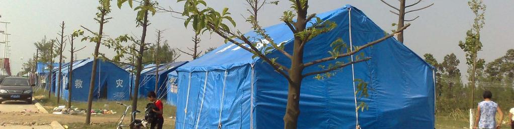
73 Liquefaction in Pixian

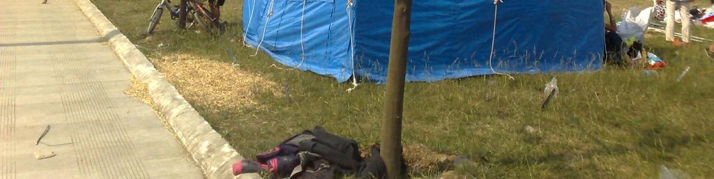
74 Quake Lake at Tangjiashan

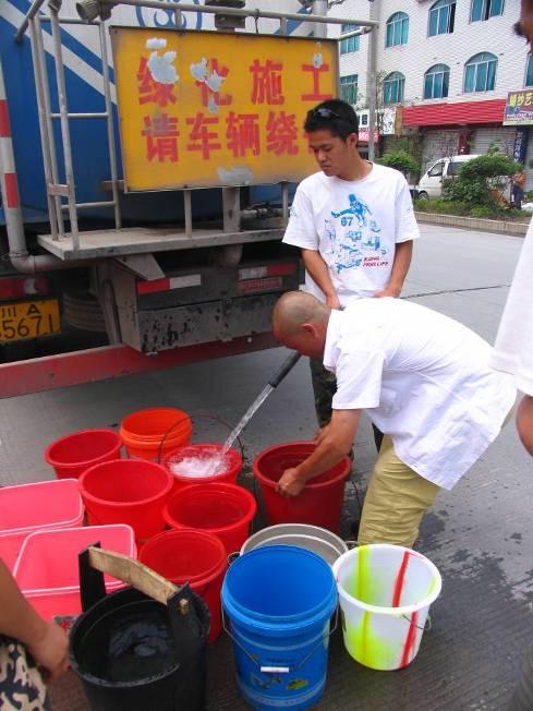
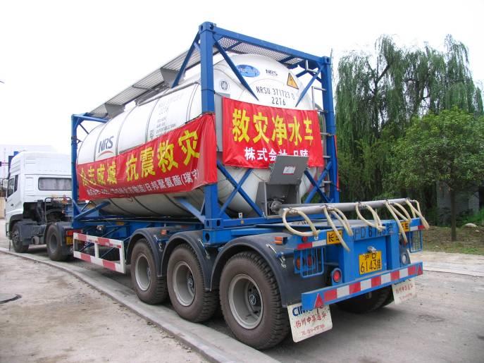
75 Mudslide Jiufengshan, Pengzhou

76 Fault Rupture near Beichuan

77 Rupture along a road to Beichuan County

78 Fault Rupture in Pingtong town in Pingwu County
79 4. Response and Reconstruction
80 Daily number of death, injury and rescued


81 Emergency response personnel seen everywhere

82 Tents were set up everywhere


83 Water and food quickly delivered to rural areas


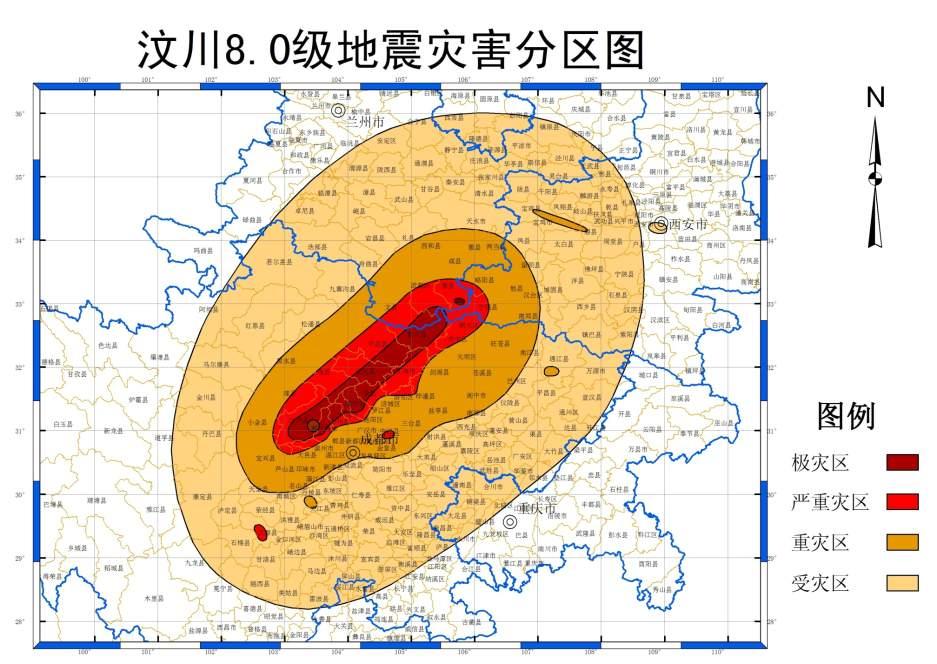
84 Water supply response, restored < 20days
85 Emergency response Merit of a centralized government Medical, mental help Supply for daily life needs Monetary help
86 Reconstruction National committee National guidelines Financial support Engineering support Local plans Execution: 3 years of reconstruction, 5 years of improvement
87 Building evaluation No damage: inhabitable Slight damage: inhabitable with possible future retrofitting Medium damage: repair Heavy damage: rebuild Collapse: rebuild

88 Relationship of design earthquake with different level and average return period(suggested)

89 Modified PGA Zonation (change building type for schools)
90 Financial support Central government: 70b Local government: ~30b Donations: ~ 50b Total: 150b RMB, 20+b USD for 2008
91 5Loss estimate

92 Estimated intensity right after the event with a point source

93 Damage ratio distribution Total loss: 983 b (building only)

94 RMS/IEM casualty estimate: 18,000~33,000 (building only, this number helped the government making decisions to dispatch more troops )

95 Distribution of field survey locations
96
97 Concluding remarks We know little about earthquakes Effectiveness of seismic design Economically effective structures for rural areas Design earthquakes for public facilities Importance of lifeline systems Wide spread issue with geotechnical failures Risk diversification
Brief introduction to recovery and reconstruction
 Brief introduction to recovery and reconstruction of Wenchuan earthquake stricken region He Yongnian China Earthquake Administration May 2011 Major parameters of Wenchuan earthquake Original time: 14:28,
INTRODUCTION AND PRELIMINARY ANALYSIS OF STRONG MOTION RECORDINGS FROM THE 12 MAY 2005 Ms8.0 WENCHUAN EARTHQUAKE OF CHINA
 INTRODUCTION AND PRELIMINARY ANALYSIS OF STRONG MOTION RECORDINGS FROM THE 12 MAY 2005 Ms8.0 WENCHUAN EARTHQUAKE OF CHINA Li Xiaojun 1, Zhou Zhenghua 1, Huang Moh 3, Wen Ruizhi 1, Yu Haiyin 1, Lu Dawei
Vulnerability Study of Electric Power Grid in Different Intensity Area in Wenchuan Earthquake
 Vulnerability Study of Electric Power Grid in Different Intensity Area in Wenchuan Earthquake R.S. Liu, M.J. Zhang & Y.B. Wu Institute of Engineering Mechanics, China Earthquake Administration, Harbin
Relationships between ground motion parameters and landslides induced by Wenchuan earthquake
 Earthq Sci (2010)23: 233 242 233 Doi: 10.1007/s11589-010-0719-5 Relationships between ground motion parameters and landslides induced by Wenchuan earthquake Xiuying Wang 1, Gaozhong Nie 2 and Dengwei Wang
Ground motion attenuation relations of small and moderate earthquakes in Sichuan region
 Earthq Sci (2009)22: 277 282 277 Doi: 10.1007/s11589-009-0277-x Ground motion attenuation relations of small and moderate earthquakes in Sichuan region Lanchi Kang 1, and Xing Jin 1,2 1 Fuzhou University,
Reconnaissance report and preliminary ground motion simulation of the 12 May 2008 Wenchuan earthquake
 Bull Earthquake Eng (2010) 8:1569 1601 DOI 10.1007/s10518-010-9198-2 ORIGINAL RESEARCH PAPER Reconnaissance report and preliminary ground motion simulation of the 12 May 2008 Wenchuan earthquake Louise
Data Processing and Analysis of Strong Motion Records from the Ms8.0 Wenchuan, China Earthquake
 Data Processing and Analysis of Strong Motion Records from the Ms8. Wenchuan, China Earthquake Haiying Yu, Wenxiang Jiang, Yongqiang Yang, Quancai Xie, Lei Huang, Pingyu Tan, Li Li Institute of Engineering
DESIGN HUMAN-COMPUTER INTERACTION SYSTEM TO BUILD ISOSEISMAL.
 ABSTRACT : DESIGN HUMAN-COMPUTER INTERACTION SYSTEM TO BUILD ISOSEISMAL. Ping Li 1 and Xiaxin Tao 2 1. PHD candidate, School of Civil Engineering, Harbin Institute of Technology, Harbin. China 2. Professor,
The Magnitude 7.2 Earthquake from the West Valley Fault: Implications for Metro Manila and Nearby Provinces
 The Magnitude 7.2 Earthquake from the West Valley Fault: Implications for Metro Manila and Nearby Provinces First DRI Collegiate Conference in the Philippines 16 March 2017 Renato U. Solidum, Jr. Department
Characteristics of Secondary Mountain Disaster Chain in Wenchuan Earthquake
 American Journal of Civil Engineering 2017; 5(6): 408-413 http://www.sciencepublishinggroup.com/j/ajce doi: 10.11648/j.ajce.20170506.23 ISSN: 2330-8729 (Print); ISSN: 2330-8737 (Online) Characteristics
Received: 28 September 2010 / Accepted: 15 September 2011 / Published online: 29 September 2011 Springer Science+Business Media B.V.
 Bull Earthquake Eng (2012) 10:741 764 DOI 10.1007/s10518-011-9318-7 ORIGINAL RESEARCH PAPER The use of remotely sensed data and ground survey tools to assess damage and monitor early recovery following
HAZUS-MH: Earthquake Event Report
 HAZUS-MH: Earthquake Event Report Region Name: El Paso County Earthquake Scenario: El Paso County Random EQ Print Date: February 08, 2006 Disclaimer: The estimates of social and economic impacts contained
The sketch map of field investigations in Wenchuan earthquake hit region, Chengdu City.
 The sketch map of field investigations in Wenchuan earthquake hit region, Chengdu City. 1 Environmental and Geological Condition 1.1 Geomorphology BaiSha River Basin is located in Dujiangyan County, and
CHINA: EARTHQUAKES. The Disaster. Information Bulletin N January, 2000
 CHINA: EARTHQUAKES 17 January, 2 Information Bulletin N 1 The Disaster At 22.9 and 23.37 on Friday 14 January 2, two earthquakes measuring 6. and 6.5 in magnitude respectively hit the county of Yao'an
NPTEL Online - IIT Kanpur. Course Name Geotechnical Earthquake Engineering. Department IIT Kanpur
 NPTEL Online - IIT Kanpur Course Name Geotechnical Earthquake Engineering Department Instructor Civil Engineering Department IIT Kanpur Prof. N.R. Patra Module 1 INTRODUCTION TO GEOTECHNICAL ENGINEERING
Ground motion intensity map of the Tainan earthquake (Central Weather Bureau).
.") Taiwan lies on the boundary between the Eurasian Plate and the Philippine Sea Plate, which are converging at 80 mm per year. The island is the result of uplift caused by the collision of the northern end
Taiwan lies on the boundary between the Eurasian Plate and the Philippine Sea Plate, which are converging at 80 mm per year. The island is the result of uplift caused by the collision of the northern end
Geologic Hazards. Montour County Multi-jurisdictional. General. Earthquake
 Geologic Hazards General s are very rare in Pennsylvania and have caused little damage with no reported injuries or causalities. s that do occur in Pennsylvania happen deep within the Earth s crust. This
Evaluating the Vegetation Recovery in the Damage Area of Wenchuan Earthquake Using MODIS Data
 University of Nebraska - Lincoln DigitalCommons@University of Nebraska - Lincoln Community and Regional Planning Program: Faculty Scholarly and Creative Activity Community and Regional Planning Program
Sampling Scheme for 2003 General Social Survey of China
 Sampling Scheme for 2003 General Social Survey of China 1. Sampling Unit This survey uses a five-stage stratified sampling scheme with unequal probabilities. The sampling units at each stage are as follows:
Damage and Restoration of Drinking Water Systems Caused by 0206 Tainan Earthquake and Future Mitigation Measures
 Damage and Restoration of Drinking Water Systems Caused by 0206 Tainan Earthquake and Future Mitigation Measures Nan-Tzer Hu 1. Overview of 0206 Earthquake s At 03:57 local time (19:57 UTC) on 6 February
Study on the Effect of Loess Sites on Seismic Ground Motion and Its Application in Seismic Design
 6 th International Conference on Earthquake Geotechnical Engineering 1-4 November 2015 Christchurch, New Zealand Study on the Effect of Loess Sites on Seismic Ground Motion and Its Application in Seismic
A Prototype Earthquake Early Warning (EEW) System in Beijing Capital Region of China
 System in Beijing Capital Region of China") The 2th International Workshop On Earthquake Early Warning, April 21-22, 2009, Kyoto, Japan A Prototype Earthquake Early Warning (EEW) System in Beijing Capital Region of China Hanshu Peng 1, Zhongliang
The 2th International Workshop On Earthquake Early Warning, April 21-22, 2009, Kyoto, Japan A Prototype Earthquake Early Warning (EEW) System in Beijing Capital Region of China Hanshu Peng 1, Zhongliang
Borah Peak Earthquake HAZUS Scenario Project Executive Summary Idaho Bureau of Homeland Security Idaho Geological Survey Western States Seismic
 Borah Peak Earthquake HAZUS Scenario Project Executive Summary Idaho Bureau of Homeland Security Idaho Geological Survey Western States Seismic Policy Council 12/30/2008 The HAZUS-MH analysis of the Borah
State of art of seismic design and seismic hazard analysis for oil and gas pipeline system
 Earthq Sci (2010)23: 259 263 259 Doi: 10.1007/s11589-010-0721-y State of art of seismic design and seismic hazard analysis for oil and gas pipeline system Aiwen Liu Kun Chen and Jian Wu Institute of Geophysics,
Response Analysis of a Buried Pipeline Considering the
 Response Analysis of a Buried Pipeline Considering the process Process of fault Fault movement Movement A.W. Liu, X.H. Jia Institute of Geophysics, CEA, China SUMMARY: For the seismic design of a pipeline
Earthquake Hazards in Douglas County
 Earthquake Hazards in Douglas County Craig M. depolo Nevada Bureau of Mines and Geology Nevada Hazard Mitigation Planning Committee August 9, 2012 Earthquake Truths The consequences of bad earthquakes
Multi Hazard Evaluation of a High Voltage Transmission Network. John Eidinger 1 and Leon Kempner 2
 Multi Hazard Evaluation of a High Voltage Transmission Network John Eidinger 1 and Leon Kempner 2 1 G&E Engineering Systems Inc., P. O. Box 3592 Olympic Valley, CA 96146-3592; eidinger@earthlink.net. 2
Monitoring Geologic Hazards and Vegetation Recovery in the Wenchuan Earthquake Region Using Aerial Photography
 ISPRS Int. J. Geo-Inf. 2014, 3, 368-390; doi:10.3390/ijgi3010368 Article ISPRS International Journal of Geo-Information ISSN 2220-9964 www.mdpi.com/journal/ijgi/ Monitoring Geologic Hazards and Vegetation
THE STUDY ON 4S TECHNOLOGY IN THE COMMAND OF EARTHQUAKE DISASTER EMERGENCY 1
 THE STUDY ON 4S TECHNOLOGY IN THE COMMAND OF EARTHQUAKE DISASTER EMERGENCY 1 Zhou Wensheng 1, Huang Jianxi 2, Li Qiang 3, Liu Ze 3 1 Associate Professor, School of Architecture, Tsinghua University, Beijing.
Important Concepts. Earthquake hazards can be categorized as:
 Lecture 1 Page 1 Important Concepts Monday, August 17, 2009 1:05 PM Earthquake Engineering is a branch of Civil Engineering that requires expertise in geology, seismology, civil engineering and risk assessment.
Effects of Surface Geology on Seismic Motion
 4 th IASPEI / IAEE International Symposium: Effects of Surface Geology on Seismic Motion August 23 26, 2011 University of California Santa Barbara RECENT EXPERIENCE AND PRACTICE FOR STRONG MOTION OBSERVATION
Lightning Casualties and Damages in China from 1997 to 2009
 Lightning Casualties and Damages in China from 1997 to 2009 Wenjuan ZHANG 1, Qing MENG 1, Ming MA 2, Yijun ZHANG 1 1 Laboratory of Lightning Physics and Protection Engineering, Chinese Academy of Meteorological
21 Re-Development, Recovery and Mitigation After the 2010 Catastrophic Floods: The Pakistani Experience Sana Khosa
 Contents xv 19 California Seismic Safety Commission: Multi-disciplinary Collaboration for Seismic Safety Mitigation... 331 Frances L. Edwards and Daniel C. Goodrich 20 Multi-sector Partnerships in Disaster
Surface rupture and hazard characteristics of the Wenchuan Ms 8.0 earthquake, Sichuan, China *
 Vol.2, No.3, 160-174 (2010) http://dx.doi.org/10.4236/ns.2010.23026 Natural Science Surface rupture and hazard characteristics of the Wenchuan Ms 8.0 earthquake, Sichuan, China * Rong-Jun Zhou 1, Yong
CITY OF RIVERSIDE USING HAZUS TO CREATE A EARTHQUAKE PLANNING GUIDE FOR A UNIFIED FIELD RESPONSE
 CITY OF RIVERSIDE USING HAZUS TO CREATE A EARTHQUAKE PLANNING GUIDE FOR A UNIFIED FIELD RESPONSE Presented by the Phil McCormick City of Riverside Office of Emergency Management HISTORY The City had several
Preparing for the BIG one Cascadia Subduction Zone Event
 Preparing for the BIG one Cascadia Subduction Zone Event Source - 2016 CZS Excercise updated Jan 2015 1 Earthquake Faults in Washington State Emergency Management Ring of Fire The Ring of Fire accounts
An earthquake can cause:
 Earthquakes An earthquake is a sudden rapid shaking of the earth. They are caused by the breaking and shifting of the rock beneath the earth s surface. Often found in conjunction with Plate tectonic boundaries.
Earthquakes and Earth s Interior
 - What are Earthquakes? Earthquakes and Earth s Interior - The shaking or trembling caused by the sudden release of energy - Usually associated with faulting or breaking of rocks - Continuing adjustment
The 2008 Wenchuan, China, earthquake
 23 The 2008 Wenchuan, China, earthquake Zhongliang Wu and Tengfei Ma 23.1 Introduction The 12 May 2008 Wenchuan M S 8.0/ M W 7.9 earthquake in southwest China was one of the great earthquakes, and was
Earthquake Hazards in Henderson
 Earthquake Hazards in Henderson Craig M. depolo Nevada Bureau of Mines and Geology Nevada Hazard Mitigation Planning Committee November 15, 2012 Earthquake Truths The consequences of bad earthquakes to
1. Why do earthquakes happen? 3. What type of mechanical waves are Primary or P waves? 4. What type of mechanical waves are Secondary or S waves?
 Name Period Earthquake Activity Background Information Earthquakes occur because of a sudden release of stored energy. This energy has built up over long periods of time as a result of tectonic forces
Research Article Seismic Structure of Local Crustal Earthquakes beneath the Zipingpu Reservoir of Longmenshan Fault Zone
 International Geophysics Volume 11, Article ID 773, pages doi:.11/11/773 Research Article Seismic Structure of Local Crustal Earthquakes beneath the Zipingpu Reservoir of Longmenshan Fault Zone Haiou Li,
M-6.2 EARTHQUAKE NORCIA, ITALY AUGUST 24, 01:36:33 UTC
 M-6.2 EARTHQUAKE NORCIA, ITALY AUGUST 24, 2016 @ 01:36:33 UTC EARTHQUAKE REPORT - NORCIA, ITALY M-6.2, 24 August 2016 The M-6.2 earthquake had a shallow depth (10 km) and struck approximately 10 km SE
VIDEO The 2011 Japanese Earthquake and Tsunami
 VIDEO The 2011 Japanese Earthquake and Tsunami Why was it so large and devastating? Why so short a warning? Why did tsunami precautions fail? What happened elsewhere? The Loma Prieta Earthquake (1989)
Characteristics of seismic activity before the M S 8.0 Wenchuan earthquake
 Earthq Sci (2009)22: 519 529 519 Doi: 10.1007/s11589-009-0519-4 Characteristics of seismic activity before the M S 8.0 Wenchuan earthquake Yan Xue 1,2, Jie Liu 2 Shirong Mei 3 and Zhiping Song 4 1 Institute
Analysis for Regional Differences and Influence Factor of Rural Income in China
 Modern Economy, 2012, 3, 578-583 http://dx.doi.org/10.4236/me.2012.35076 Published Online September 2012 (http://www.scirp.org/journal/me) Analysis for Regional Differences and Influence Factor of Rural
ÖBB Natural Hazard Management
 ÖBB Natural Hazard Management Management of Weather Events in the Austrian Federal Railways MOWE-IT, Brussels 17 th of September 2013 DI Günther Kundela Integrated Track Management Integration Technic
Towards an Improved Method for Earthquake Induced Landslide Susceptibility and Hazard
 Towards an Improved Method for Earthquake Induced Landslide Susceptibility and Hazard Tolga GORUM Department of Earth Systems Analysis International Institute for Geoinformation Science and Earth Observation
GIS: Assessment Model and Evaluation of an Earthquake-stricken Area with a Case Study in Shangri-La
 , pp.123-138 http://dx.doi.org/10.14257/ijhit.2014.7.4.11 GIS: Assessment Model and Evaluation of an Earthquake-stricken Area with a Case Study in Shangri-La Shuangyun Peng 1, Kun Yang 1 and Yanbo Cao
Collapse Analysis of Jointed Rock Slope Based on UDEC Software and Practical Seismic Load
 Available online at www.sciencedirect.com Procedia Engineering 31 (2012) 441 446 International Conference on Advances in Computational Modeling and Simulation Collapse Analysis of Jointed Rock Slope Based
Relocation of aftershocks of the Wenchuan M S 8.0 earthquake and its implication to seismotectonics
 Earthq Sci (2011)24: 107 113 107 doi:10.1007/s11589-011-0774-6 Relocation of aftershocks of the Wenchuan M S 8.0 earthquake and its implication to seismotectonics Bo Zhao Yutao Shi and Yuan Gao Institute
Mechanism of post-seismic floods after the Wenchuan earthquake in the upper Minjiang River, China
 J. Earth Syst. Sci. (2017) 126:96 c Indian Academy of Sciences DOI 10.1007/s12040-017-0871-6 Mechanism of post-seismic floods after the Wenchuan earthquake in the upper Minjiang River, China Ding Hairong
(First Edition: prepared on 29/12/2003)
") (First Edition: prepared on 29/12/2003) Dr Sassan Eshghi 1 and Dr Mehdi Zaré 2 International Institute of Earthquake Engineering and Seismology, Tehran, P.O.Box: 19395/3913, IRAN e-mails: 1)s.eshghi@iiees.ac.ir,
(First Edition: prepared on 29/12/2003) Dr Sassan Eshghi 1 and Dr Mehdi Zaré 2 International Institute of Earthquake Engineering and Seismology, Tehran, P.O.Box: 19395/3913, IRAN e-mails: 1)s.eshghi@iiees.ac.ir,
Evaluation of factors controlling large earthquake-induced landslides by the Wenchuan earthquake
 doi:10.5194/nhess-12-3645-2012 Author(s) 2012. CC Attribution 3.0 License. Natural Hazards and Earth System Sciences Evaluation of factors controlling large earthquake-induced by the Wenchuan earthquake
Bangladesh in Risk of Earthquake: What Can Be Done. Presented By : Md.Jahangir Alam Coordinator, Disaster Management Unit Dhaka Ahsania Mission
 Bangladesh in Risk of Earthquake: What Can Be Done Presented By : Md.Jahangir Alam Coordinator, Disaster Management Unit Dhaka Ahsania Mission What are Earthquakes? The shaking /ground vibration caused
Geology 229 Engineering Geology Lecture 27. Earthquake Engineering (Reference West, Ch. 18)
") Geology 229 Engineering Geology Lecture 27 Earthquake Engineering (Reference West, Ch. 18) Earthquake Engineering 1. General introduction of earthquakes 2. Seismic Hazards 3. Strong ground motion Exactly
Geology 229 Engineering Geology Lecture 27 Earthquake Engineering (Reference West, Ch. 18) Earthquake Engineering 1. General introduction of earthquakes 2. Seismic Hazards 3. Strong ground motion Exactly
Resiliency Assessed by Comparing Scenarios
 Resiliency Assessed by Comparing Scenarios Robert A. Bauer Illinois State Geological Survey Use HAZUS to estimate losses from nearby strong events vs. NLE-11 New Madrid Catastrophic M7.7 and NLE-11 Mt.
Earthquakes. Earthquakes and Plate Tectonics. Earthquakes and Plate Tectonics. Chapter 6 Modern Earth Science. Modern Earth Science. Section 6.
 Earthquakes Chapter 6 Modern Earth Science Earthquakes and Plate Tectonics Section 6.1 Modern Earth Science Earthquakes and Plate Tectonics Earthquakes are the result of stresses in Earth s s lithosphere.
Forces in Earth s Crust
 Name Date Class Earthquakes Section Summary Forces in Earth s Crust Guide for Reading How does stress in the crust change Earth s surface? Where are faults usually found, and why do they form? What land
A RECONNAISANCE REPORT THE PISCO, PERU EARTHQUAKE OF AUGUST 15, 2007
 Pisco Earthquake, Peru, August 15, 2007 A RECONNAISANCE REPORT ON THE PISCO, PERU EARTHQUAKE OF AUGUST 15, 2007 Jörgen Johansson Tatiana Torres Paola Mayorca Edwin Leon 2007 Pisco, Peru Earthquake Reconnaissance
Study on the Site Effects on Ground Motion during the Wenchun Ms8.0 Earthquake,China
 Study on the Site Effects on Ground Motion during the Wenchun Ms8. Earthquake,China Lanmin Wang, Zhijian Wu Lanzhou Institute of Seismology, China Earthquake Administration (CEA), No. 45 Donggangxi Ave.
The earthquake in Jiuzhaigou County of Northern Sichuan, China on August 8, 2017
 DOI 10.1007/s11069-017-3064-3 SHORT COMMUNICATION The earthquake in Jiuzhaigou County of Northern Sichuan, China on August 8, 2017 Hao Lei 1,2 Xiuling Wang 2 Deqiang Yu 2 Hao Wang 3 Hang Hou 2 Linjian
Coseismic surface-ruptures and crustal deformations of the 2008 Wenchuan earthquake Mw7.9, China
 GEOPHYSICAL RESEARCH LETTERS, VOL. 36, L11303, doi:10.1029/2009gl037971, 2009 Coseismic surface-ruptures and crustal deformations of the 2008 Wenchuan earthquake Mw7.9, China Ken Xiansheng Hao, 1 Hongjun
A Preliminary Reconnaissance Report on August 11 th 2012, Varzaghan-Ahar Twin Earthquakes in NW Of Iran
 A Preliminary Reconnaissance Report on August 11 th 2012, Varzaghan-Ahar Twin Earthquakes in NW Of Iran Mehran S. Razzaghi Assistant Professor, Qazvin Branch, Islamic Azad University, Member of IEEA Mohsen
SEISMIC RISK ASSESSMENT IN ARMENIA
 SEISMIC RISK ASSESSMENT IN ARMENIA Hovhannes Khangeldyan Head of National Crisis Management Center Rescue Service Ministry of Emergency Situations of the Republic of Armenia Tokyo, 2016 ARMENIA: GEOGRAPHICAL
Information Note. Organized by. National Administration of Surveying, Mapping and Geoinformation of China (NASG)
") Chengdu Forum on UN-GGIM Global Map for Sustainable Development: Development and Applications in Urban Hazard Mapping 15-17 October 2013, Chengdu, China Information Note Organized by National Administration
Chengdu Forum on UN-GGIM Global Map for Sustainable Development: Development and Applications in Urban Hazard Mapping 15-17 October 2013, Chengdu, China Information Note Organized by National Administration
A RECONNAISSANCE REPORT ON 2008 WENCHUAN EARTHQUAKE*
 Dedicated to the people who lost their lives and injured by the 2008 Wenchuan Earthquake A RECONNAISSANCE REPORT ON 2008 WENCHUAN EARTHQUAKE* Japan Society of Civil Engineers Earthquake Engineering Committee
Earthquake Disaster Assessment on May 27 Ms 6.2 Yogyakarta Earthquake of Indonesia
 Earthquake Disaster Assessment on May 27 Ms 6.2 Yogyakarta Earthquake of Indonesia Qu Guosheng, Zhao Fengxin, Huang Jianfa, Li Yigang, Li Yanfeng, Du Xiaoxia and Ning Baokun1 National Earthquake Response
China Wenchuan Earthquake Disaster (May ) and Its Loss Assessment
 and Its Loss Assessment") International Disaster and Risk Conference Davos 2008, August 25-29, Switzerland China Wenchuan Earthquake Disaster (May 12.2008) and Its Loss Assessment Peijun SHI Disaster Assessment Group of the National
International Disaster and Risk Conference Davos 2008, August 25-29, Switzerland China Wenchuan Earthquake Disaster (May 12.2008) and Its Loss Assessment Peijun SHI Disaster Assessment Group of the National
Xiang Wen, & Takahashi Toru Chiba University, Chiba City, Japan. Katada Masaki Kyoto University, Kyoto, Japan
 Damage Scenario and Its Reduction for Nishi-Chiba Campus, Chiba University due to Tokai, Tonankai, Nankai Coupled Earthquake and The Capital, Tokyo Inland Earthquake Xiang Wen, & Takahashi Toru Chiba University,
GENERAL. CHAPTER 1 BACKGROUND AND PURPOSE OF THE GUIDELINES Background of the Guidelines Purpose of the Guidelines...
 GENERAL CHAPTER 1 BACKGROUND AND PURPOSE OF THE GUIDELINES... 1 1.1 Background of the Guidelines... 1 1.2 Purpose of the Guidelines... 3 CHAPTER 2 APPLICATION OF THE GUIDELINES... 3 2.1 Potential Users
City of Punta Gorda Community Emergency Management Plan 2013
 City of Punta Gorda Community Emergency Management Plan 2013 Hurricane Andrew- August 24, 1992 Category 5 hurricane. The second-most-destructive hurricane in U.S. history. The first named storm of the
Earthquakes.
 Earthquakes http://thismodernworld.com/comic-archive Elastic rebound http://projects.crustal.ucsb.edu/understanding/elastic/rebound.html Elastic rebound Rocks store energy elastically When stored stress
Asymmetrical Disaster Distribution and its Cause Analysis of the Mw7.9 Wenchuan Earthquake
 Asymmetrical Disaster Distribution and its Cause Analysis of the Mw7.9 Wenchuan Earthquake Qing Zhou, Xiancheng Chen Key Laboratory of Active Tectonics and Volcano, Institute of Geology, China Earthquake
GIS-BASED EARTHQUAKE DISASTER PREDICTION AND OPTIMUM PATH ANALYSIS FOR THE URBAN ROAD TRANSIT SYSTEM
 GIS-BASED EARTHQUAKE DISASTER PREDICTION AND OPTIMUM PATH ANALYSIS FOR THE URBAN ROAD TRANSIT SYSTEM ABSTRACT: NI Yongjun 1, WANG Wanhong 1, HUANG Shimin 2, FU Shengcong 2 and OU Xianren 3 1. Ph.D, Associate
2.3 Notes: Earthquake Damage Can Be Reduced
 2.3 Notes: Earthquake Damage Can Be Reduced Earthquakes can cause severe damage and loss of life Each year, there is about one earthquake with a magnitude of or higher-this is an extremely earthquake.
Mw 7.8, Southwest of Sumatra, Indonesia Wed, 2 March 2016 at 12:49:48 UTC M /03/03
 Earthquake overview AFGHANISTA N PAKISTA N INDIA A moment magnitude (Mw) 7.8 earthquake struck in South West, Indonesia. The epicentre was centered about 800 km West South West of Padang, Sumatra province,
Trends of Natural Disasters in the Asia- Pacific Region and the Direction of Disaster Management
 2016 APEC SCCC, Arequipa, Peru Session 6 - Human Security: Food, Health, Natural Disasters and Environmental Issues Trends of Natural Disasters in the Asia- Pacific Region and the Direction of Disaster
Dam Safety Aspects of Reservoir-Triggered Seismicity
 Dam Safety Aspects of Reservoir-Triggered Seismicity Dr. Martin Wieland Chairman, Committee on Seismic Aspects of Dam Design, International Commission on Large Dams (ICOLD) Poyry Energy Ltd., Zurich, Switzerland
RISK OF PRINCIPAL DISASTERS IN INDIA AND IMPACTS OF DISASTERS ON ECONOMIC DEVELOPMENT
 RISK OF PRINCIPAL DISASTERS IN INDIA AND IMPACTS OF DISASTERS ON ECONOMIC DEVELOPMENT At the Himachal Pradesh Institute of Public Administration Shimla 05. 05.2012 Improve Disaster Management with the
Seismic Response Analysis of selected sites in Wenxian urban area, China
 Seismic Response Analysis of selected sites in Wenxian urban area, China Y. Lu, K. Liu & Q. Li Earthquake Administration of Gansu Province (Key Laboratory of Loess Earthquake Engineering, CEA),China Y.
Earthquakes. These icons indicate that teacher s notes or useful web addresses are available in the Notes Page.
 Earthquakes These icons indicate that teacher s notes or useful web addresses are available in the Notes Page. This icon indicates the slide contains activities created in Flash. These activities are not
EXECUTIVE SUMMARY. The title of this dissertation is Quantitative Study on Natural Disasters Risk
 1 EXECUTIVE SUMMARY The title of this dissertation is Quantitative Study on Natural Disasters Risk Management Policy Applying Statistical Data Analysis and Mathematical Modeling Approach. This research
Guidelines for Site-Specific Seismic Hazard Reports for Essential and Hazardous Facilities and Major and Special-Occupancy Structures in Oregon
 Guidelines for Site-Specific Seismic Hazard Reports for Essential and Hazardous Facilities and Major and Special-Occupancy Structures in Oregon By the Oregon Board of Geologist Examiners and the Oregon
Pengcheng Su (*,**,***), Fangqian Wei (**,***), Zunlan Cheng (**,***) & Jingjing Liu (*,**,***)
, Fangqian Wei (**,***), Zunlan Cheng (**,***) & Jingjing Liu (*,**,***)") DOI: 10.4408/IJEGE.2011-03.B-084 Debris flows in Mozi gully, China following the 2008 Wenchuan earthquake Pengcheng Su (*,**,***), Fangqian Wei (**,***), Zunlan Cheng (**,***) & Jingjing Liu (*,**,***)
DOI: 10.4408/IJEGE.2011-03.B-084 Debris flows in Mozi gully, China following the 2008 Wenchuan earthquake Pengcheng Su (*,**,***), Fangqian Wei (**,***), Zunlan Cheng (**,***) & Jingjing Liu (*,**,***)
7.3 Magnitude Earthquake Strikes Iran-Iraq Border
 7.3 Magnitude Earthquake Strikes Iran-Iraq Border KEY POINTS A magnitude 7.3 earthquake has struck the Iran-Iraq border with at least 348 fatalities reported. Thousands more have been injured and many
Preliminary Earthquake Risk Management Strategy Plan of Eskisehir, Turkey by using GIS
 Preliminary Earthquake Risk Management Strategy Plan of Eskisehir, Turkey by using GIS Metin Altan, Ferah Özturk and Can Ayday Space and Satellite Sciences Research Institute Anadolu University, TURKEY
Seismic hazard expression in risk assessment
 Earthquae Resistant Engineering Structures VI 299 Seismic hazard expression in ris assessment X.-X. Tao 1, 2, Z.-R. Tao 2 & P. Li 1 1 Harbin Institute of Technology, People s Republic of China 2 Institute
APPLICATIONS OF EARTHQUAKE HAZARD MAPS TO LAND-USE AND EMERGENCY PLANNING EXAMPLES FROM THE PORTLAND AREA
 APPLICATIONS OF EARTHQUAKE HAZARD MAPS TO LAND-USE AND EMERGENCY PLANNING EXAMPLES FROM THE PORTLAND AREA O. Gerald Uba Metro, Portland, Oregon OVERVIEW The extent to which we understand "below ground"
Geology, Soils, and Seismicity
 Section 3.8 Geology, Soils, and Seismicity Introduction This section generally evaluates the effects of the alternatives analyzed in this Supplemental DEIS with regard to geology, soils and seismicity.
Ömer AYDAN. Ismail FEBRIN. Fumihiko IMAMURA KOGAMI (Tsunami Alert Community-NPO)
") ( ) JSCE-JAEE Team Andalas University Ömer AYDAN Ismail FEBRIN Fumihiko IMAMURA Abdul HAKAM Mas MERA KOGAMI (Tsunami Alert Community-NPO) Tomoji SUZUKI Patra Rina DEWI 10 4 10 9 LOCATION Padang Sikuai
( ) JSCE-JAEE Team Andalas University Ömer AYDAN Ismail FEBRIN Fumihiko IMAMURA Abdul HAKAM Mas MERA KOGAMI (Tsunami Alert Community-NPO) Tomoji SUZUKI Patra Rina DEWI 10 4 10 9 LOCATION Padang Sikuai
Surviving the Big One: Understanding and Preparing for a Major Earthquake in Western Oregon
 Surviving the Big One: Understanding and Preparing for a Major Earthquake in Western Oregon May 21, 2013 City of Salem Salem Public Library Althea Rizzo, Geological Hazards Program Coordinator Oregon Emergency
KENTUCKY HAZARD MITIGATION PLAN RISK ASSESSMENT
 KENTUCKY HAZARD MITIGATION PLAN RISK ASSESSMENT Presentation Outline Development of the 2013 State Hazard Mitigation Plan Risk Assessment Determining risk assessment scale Census Data Aggregation Levels
GY 111: Physical Geology
 UNIVERSITY OF SOUTH ALABAMA GY 111: Physical Geology Lecture 31: Mountain Building 1: Isostasy and Thrusting Last Time Earthquakes A) Earthquake intensity and magnitude B) Seismographs C) Case Studies
Evaluation on Social Vulnerability to Natural Disasters
 Kamla-Raj 2016 Anthropologist, 24(2): 570-580 (2016) Evaluation on Social Vulnerability to Natural Disasters Xuxian Yan 1 and Xianjun Li 2 1 College of Management Science and Engineering, Shanxi University
Uneven aftershock distribution of Wenchuan Ms 8. 0 earthquake and possible mechanism
 Geodesy and Geodynamics 211,2(2) :7-12 http://www. jgg9. com Doi:1.3724/SP.J.1246.211.7 Uneven aftershock distribution of Wenchuan Ms 8. earthquake and possible mechanism Li Zhixiong 1,Chen Zhangli 2,
Copernicus Overview. Major Emergency Management Conference Athlone 2017
 Copernicus Overview Major Emergency Management Conference Athlone 2017 Copernicus is a European programme implemented by the European Commission. The services address six thematic areas: land, marine,
UNIT - 7 EARTHQUAKES
 UNIT - 7 EARTHQUAKES WHAT IS AN EARTHQUAKE An earthquake is a sudden motion or trembling of the Earth caused by the abrupt release of energy that is stored in rocks. Modern geologists know that most earthquakes
Progress of Space Technology Application for Disaster Management in China
 Progress of Space Technology Application for Disaster Management in China LI Qun Department of Disaster Relief Ministry of Civil Affairs of P.R.China Background drought 1 2 flood earthquake typhoon Progress
Earthquake Hazards in Washoe County
 Earthquake Hazards in Washoe County Craig M. depolo Nevada Bureau of Mines and Geology Nevada Hazard Mitigation Planning Committee August 13, 2013 Earthquake Truths The consequences of damaging earthquakes