Integrated Watershed Modeling of the Mystic River: Developing the Right Tools for Climate Change Preparedness
|
|
|
- Amberly Sophia Nicholson
- 5 years ago
- Views:
Transcription


1 Integrated Watershed Modeling of the Mystic River: Developing the Right Tools for Climate Change Preparedness David Bedoya, PhD, PE Yovanni Cataño-Lopera, PhD, PE Nicholas Stepina, PE Date
2 Presentation Overview 1 Cambridge CCVA 2 The Alewife Brook Area 3 Hydraulic Model Integration 4 Hydraulic Model Calibration and Validation 5 Potential Future Uses 6 Conclusions

3 1 Cambridge CCVA, Part 1 Source: 2014 U.S. National Climate Assessment Report

4 Cambridge CCVA, Part 1 Increase in Precipitation Source: 2015 Cambridge CCVA, Part 1 Click to edit Master text styles
5 Cambridge CCVA, Part 1 SLR/SS Source: NOAA (2012). Global Sea Level Rise Scenarios for the United States National Climate Assessment Click to edit Master text styles
6 Flood Modeling in the CCVA Riverine Overbank Flooding from Precipitation Captured using HEC-RAS model Sewer System Flooding from Precipitation or River Backups Captured Using City s Infoworks ICM Model Riverine Overbank Flooding from SLR/SS events Captured using ADCIRC in the BH-FRM

7 Sewer System Flooding from Precipitation


8 Riverine and Sewer System Flooding from Precipitation

9 Riverine Flooding from SLR/SS
10 CCVA Part 1, Conclusions Charles River Riverine overbank flooding risk is small Sewer system flooding is greatly exacerbated SLR/SS flooding risk is small and flow pathways are localized Alewife Brook Riverine overbank flooding is significantly increased Sewer system flooding is increased SLR/SS flood risk and severity are greatly increased by the end of the century
11 2 The Alewife Brook Area This region of Cambridge is the most vulnerable to flooding under climate change Flooding risk is augmented by increased precipitation up to midcentury as well as SLR/SS at the end of the century The Alewife area will be impacted by both riverine and sewer system flooding


12 2. The Alewife Brook area in the Future Title of the Movie? Source: John Sullivan, Cambridge Historical Commission
13 Challenges of a non-integrated approach Different flooding types occur at different times Flooding is generated by factors of different scale (local or system level for sewer flooding) versus watershed or regional for riverine flooding High degree of inter-dependence between systems Running scenarios and combinations of scenarios becomes cost and time prohibitive (it s also the worst nightmare for a hydraulic modeler-high chances of error)
14 3 Hydraulic Modeling Integration River Models don t include pipe systems Sewer models don t include river systems Coastal models don t include pipe systems or hydrology
15 Mystic River Watershed Model Integration Watershed scale riverine geometry and hydrologic catchments directly imported from FEMA model used for FIS Pipe model was obtained from Cambridge and MWRA regional sewer model Both models were integrated seamlessly The Cambridge floodplain was generated with a high resolution 2D grid, which includes flow path obstacles Operation of the AED was assumed different than FEMA based on communications and calibration
16 Mystic River Watershed Model Integration


17 Mystic River Watershed Model Integration Pipe-river connectivity Floodplain Terrain Model 2D-zone boundaries

18 4 Hydraulic Model Calibration and Validation Photos courtesy of Cambridge DPW
 9.59* 7.42* Peak Intensity (in/hour) 1.32 0.")
19 4 Hydraulic Model Calibration and Validation- Selected Storms March 2010 May 2006 Start Date/Time 13/8:00 12/17:30 End Date/Time 15/21:00 16/18:30 Total Rainfall (in) 9.59* 7.42* Peak Intensity (in/hour) Return Period** >50-yr ~>20-yr *At Muddy River in Brookline RG **Based on NOAA Atlas 14 Estimates at Logan Airport
20 4 Hydraulic Model Calibration -March 2010 River Gages U S G S S t a t i o n Model Meter Difference (ft) Alewife Brook Peak Stage (ft) Amelia Earhart Dam Peak Stage (ft)
21 4 Hydraulic Model Calibration -March 2010 River Gages Comparison between metered and modeled flows for the March 2010 storm event. U S G S S t a t i o n Meter Model % Difference Peak Flow (MGD) Aberjona River Volume (MG) Peak Flow (MGD) Alewife Brook Volume (MG)


22 4 Hydraulic Model Calibration -March 2010 Photographic Evidence Photographs Courtesy of Cambridge DPW

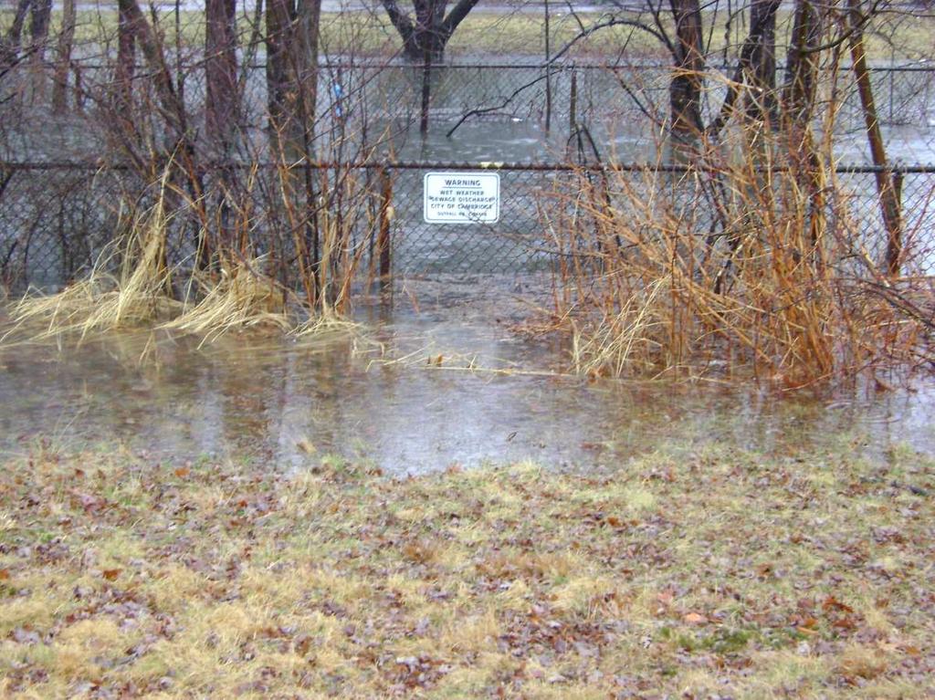


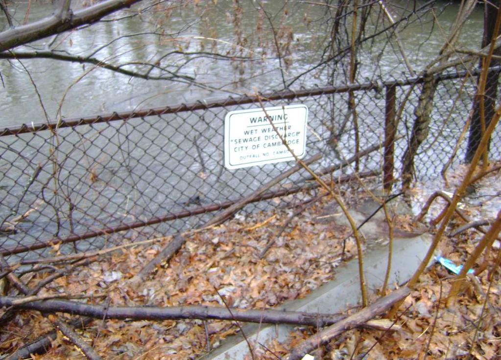


23 4 Hydraulic Model Calibration -March 2010 Photographic Evidence CAM400 Outfall CAM401B Outfall Boulevard Rd Alewife Parkway Photographs Courtesy of Cambridge DPW
24 4 Hydraulic Model Validation -Mary 2006
25 5 Previous Model Calibration
26 5 Potential Future Uses Forecast flood extents during future precipitation-driven scenarios Potential to propagate flooding from SLR/SS events Potential to asses combinations of precipitation and SLR/SS seamlessly Allow for evaluation of mitigation measures at multiple scales alone and in combination
27 5 List of Potential Local Measures Measure Sewer System Flooding River Overbank Flooding from Precipitation River Overbank Flooding from SLR/SSS Source Controls Land Use changes Peak flow retention Pathway Controls Flow Storage Flow Transfer Conveyance Capacity Increase Receptor Controls System isolation via berms, walls
28 5 List of Potential Watershed Measures Measure Sewer System Flooding River Overbank Flooding from Precipitation River Overbank Flooding from SLR/SSS Smart Reservoir Management Large Scale Land Use Changes Removal of Hydraulic Bottlenecks Increase in pumping and sluicing output
29 5 List of Potential Regional Measures Measure Sewer System Flooding River Overbank Flooding from Precipitation River Overbank Flooding from SLR/SSS Topographic changes in flanking paths Revamp of the AED (raising top of the dam) Flow isolation and real-time flow management Other large scale projects Unknown Unknown
30 Conclusions The model has been successfully integrated, calibrated, and validated It will be used to update the CCVA, Part 1 and inform the CCVA CCPR The watershed integrated can be refined with more information from watershed communities It can be used for watershed and regional decision making and to evaluate effectiveness of those decisions
31 Thank you!! Questions?
Climate Adaptation Challenges for Boston s Water and Sewer Systems
 National Association of Flood & Stormwater Management Agencies Climate Adaptation Challenges for Boston s Water and Sewer Systems John P Sullivan P.E. October 15,2014 Boston 1630 Boston 1630-2012 Boston
Risk Identification using Hazus
 Risk Identification using Hazus City of Boston, Suffolk County, MA Dave Shortman, GISP, CFM 6/21/2016 Agenda Objective Project Location Hazus Overview Hazus Level 2 Risk Assessment Comparison and Reporting
Ground Water Protection Council 2017 Annual Forum Boston, Massachusetts. Ben Binder (303)
") Ground Water Protection Council 2017 Annual Forum Boston, Massachusetts Protecting Groundwater Sources from Flood Borne Contamination Ben Binder (303) 860-0600 Digital Design Group, Inc. The Problem Houston
Ground Water Protection Council 2017 Annual Forum Boston, Massachusetts Protecting Groundwater Sources from Flood Borne Contamination Ben Binder (303) 860-0600 Digital Design Group, Inc. The Problem Houston
Mapping of Future Coastal Hazards. for Southern California. January 7th, David Revell, Ph.D. E.
 Mapping of Future Coastal Hazards for Southern California January 7th, 2014 David Revell, Ph.D. drevell@esassoc.com E. Vandebroek, 2012 Outline Coastal erosion hazard zones Flood hazard zones: Coastal
Pequabuck River Flooding Study and Flood Mitigation Plan The City of Bristol and Towns of Plainville and Plymouth, CT
 Pequabuck River Flooding Study and Flood Mitigation Plan The City of Bristol and Towns of Plainville and Plymouth, CT Raymond Rogozinski and Maged Aboelata The City of Bristol and Towns of Plainville and
CSO Post-Construction Monitoring and Performance Assessment
 Massachusetts Water Resources Authority CSO Post-Construction Monitoring and Performance Assessment Jeremy R. Hall, Project Manager Operations/Engineering & Construction Wastewater Advisory Committee December
CWMS Modeling for Real-Time Water Management
 Hydrologic Engineering Center Training Course on CWMS Modeling for Real-Time Water Management August 2018 Davis, California The Corps Water Management System (CWMS) is a software and hardware system to
South Florida Coastal Storm Surge and Mapping Study
 South Florida Coastal Storm Surge and Mapping Study Presented by Christopher Bender, Ph.D., P.E., D.CE June 2, 2015 Presentation Overview FEMA risk studies outline Overview South Florida surge study Work
Leveraging new models and data to improve flood stage forecast. Improving Flood Stage Forecasting in the Feather River Watershed. September 11 th 2015
 Leveraging new models and data to improve flood stage forecast Improving Flood Stage Forecasting in the Feather River Watershed September 11 th 2015 Mitch Russo, P.E. (DWR) Ashok Bathulla, P.E., CFM (GEI)
Modeling Great Britain s Flood Defenses. Flood Defense in Great Britain. By Dr. Yizhong Qu
 Modeling Great Britain s Flood Defenses AIRCurrents Editor s note: AIR launched its Inland Flood Model for Great Britain in December 2008. The hazard module captures the physical processes of rainfall-runoff
David R. Vallee Hydrologist-in-Charge NOAA/NWS Northeast River Forecast Center
 David R. Vallee Hydrologist-in-Charge NOAA/NWS Northeast River Forecast Center Record flooding along the Shawsheen River during the 2006 Mother s Day Floods Calibrate and implement a variety of hydrologic
Las Colonias Subdivision September 2010 Flood Study
 Las Colonias Subdivision September 2010 Flood Study Curtis Beitel, P.E., CFM Scott Muchard, P.E. Project Engineer William Badini, CFM Senior Meteorologist Location Map Background Los Colonias Subdivision
ASFPM - Rapid Floodplain Mapping
 ASFPM - Nicole Cominoli Hydraulic Engineer USACE - Omaha District mary.n.cominoli@usace.army.mil June 3, 2015 US Army Corps of Engineers Mitigation = Risk Informed Decisions 2 The National Flood Insurance
Developing Long-Term Coastal Erosion Hazard Maps ASFPM Conference Seattle, WA
 ASFPM 2014 Annual Conference Developing Long-Term Coastal Erosion Hazard Maps ASFPM Conference Seattle, WA Jeremy Mull, P.E. Elena Drei-Horgan, Ph.D. June 5 th, 2014 Presentation Outline Overview of Great
Section 4: Model Development and Application
 Section 4: Model Development and Application The hydrologic model for the Wissahickon Act 167 study was built using GIS layers of land use, hydrologic soil groups, terrain and orthophotography. Within
Flash Flood Guidance System On-going Enhancements
 Flash Flood Guidance System On-going Enhancements Hydrologic Research Center, USA Technical Developer SAOFFG Steering Committee Meeting 1 10-12 July 2017 Jakarta, INDONESIA Theresa M. Modrick Hansen, PhD
Results of Intensity-Duration- Frequency Analysis for Precipitation and Runoff under Changing Climate
 Results of Intensity-Duration- Frequency Analysis for Precipitation and Runoff under Changing Climate Supporting Casco Bay Region Climate Change Adaptation RRAP Eugene Yan, Alissa Jared, Julia Pierce,
Appendix C Fluvial Flood Hazards
 Appendix C Fluvial Flood Hazards Sea Level Rise Vulnerability Assessment and Adaptation Project March 2019 Contents Contents... i Figures... i Tables... i Definitions, Acronyms, & Abbreviations... ii
Pompton Lakes Dam Downstream Effects of the Floodgate Facility. Joseph Ruggeri Brian Cahill Michael Mak Andy Bonner
 Pompton Lakes Dam Downstream Effects of the Joseph Ruggeri Brian Cahill Michael Mak Andy Bonner ASFPM 2013: Overview Page 2 Overview Page 3 Overview Page 4 Overview Page 5 Overview - Historical Pompton
ARMSTRONG COUNTY, PA
 ARMSTRONG COUNTY, PA Revised Preliminary DFIRM Mapping March 31, 2013 Kevin Donnelly, P.E., CFM GG3, Greenhorne & O Mara, Inc. Presentation Agenda Armstrong County DFIRM Overview - June 25, 2010 DFIRM
Debris Flow Modeling & Regulations in Aspen, Colorado
 TETRA TECH River, Costal ASFPM & Engineering May 2017 Group Ft Collins Debris Flow Modeling & Regulations in Aspen, Colorado Dai Thomas, PhD, PE Andrew Earles, PhD, PE Wright Water Engineers Jim O Brien,
Changing Climate. An Engineering challenge for today and the future. Milwaukee School of Engineering December 2, 2015
 Changing Climate An Engineering challenge for today and the future David S. Liebl UW- Madison, EPD; UW-Extension; Wisconsin Initiative on Climate change Impacts Milwaukee School of Engineering December
USGS Flood Inundation Mapping of the Suncook River in Chichester, Epsom, Pembroke and Allenstown, New Hampshire
 USGS Flood Inundation Mapping of the Suncook River in Chichester, Epsom, Pembroke and Allenstown, New Hampshire NH Water & Watershed Conference Robert Flynn, USGS NH-VT Water Science Center March 23, 2012
CLIMATE READY BOSTON. Climate Projections Consensus ADAPTED FROM THE BOSTON RESEARCH ADVISORY GROUP REPORT MAY 2016
 CLIMATE READY BOSTON Sasaki Steering Committee Meeting, March 28 nd, 2016 Climate Projections Consensus ADAPTED FROM THE BOSTON RESEARCH ADVISORY GROUP REPORT MAY 2016 WHAT S IN STORE FOR BOSTON S CLIMATE?
KEY CONTROLS ON SEDIMENT BUDGETING IN THE MISSISSIPPI RIVER FROM SOURCE TO SINK
 KEY CONTROLS ON SEDIMENT BUDGETING IN THE MISSISSIPPI RIVER FROM SOURCE TO SINK Mead Allison The Water Institute of the Gulf & Tulane University What Controls the Availability of Sediment in the Restoration
HEC & GIS Modeling of the Brushy Creek HEC & GIS Watershed Modeling of the
 HEC & GIS Modeling of the Brushy Creek HEC & GIS Watershed Modeling of the By Cassandra Fagan 5, December 2014 http://ubcwatershedstudy.ursokr.com/images/ Contents Introduction... 3 Figure 1: 24-hour rainfall
Technical Memorandum No
 Pajaro River Watershed Study in association with Technical Memorandum No. 1.2.10 Task: Evaluation of Four Watershed Conditions - Sediment To: PRWFPA Staff Working Group Prepared by: Gregory Morris and
Background. Points of Discussion. Hydrographic Models
 Airborne Laser Remote Sensing Technology: Providing Essential Hydrologic Information in the 21 st Century Warwick Hadley, Optech Incorporated Presented by: Warwick Hadley Sales Manager, Middle East and
Extreme Phenomena in Dobrogea - Floods and Droughts
 Extreme Phenomena in Dobrogea - Floods and Droughts PhD eng. Carmen Maftei Ovidius University of Constanta (Partner no 4) OUTLINES Introduction Study area Drought Floods Conclusion What is the problem?
Appendix E Guidance for Shallow Flooding Analyses and Mapping
 Appendix E Guidance for Shallow Flooding Analyses and Mapping E.1 Introduction Different types of shallow flooding commonly occur throughout the United States. Types of flows that result in shallow flooding
INFLOW DESIGN FLOOD CONTROL SYSTEM PLAN 40 C.F.R. PART PLANT YATES ASH POND 2 (AP-2) GEORGIA POWER COMPANY
 GEORGIA POWER COMPANY") INFLOW DESIGN FLOOD CONTROL SYSTEM PLAN 40 C.F.R. PART 257.82 PLANT YATES ASH POND 2 (AP-2) GEORGIA POWER COMPANY EPA s Disposal of Coal Combustion Residuals from Electric Utilities Final Rule (40 C.F.R.
INFLOW DESIGN FLOOD CONTROL SYSTEM PLAN 40 C.F.R. PART 257.82 PLANT YATES ASH POND 2 (AP-2) GEORGIA POWER COMPANY EPA s Disposal of Coal Combustion Residuals from Electric Utilities Final Rule (40 C.F.R.
Flood zoning estimation and river management by using HEC-RAS and GIS model
 Int. J. Energ. Water Resour., 1(1): 13-18, Winter 2017 IRSEN, IAU Flood zoning estimation and river management by using HEC-RAS and GIS model A.R. Mardookhpour*, H. Jamasbi Department of Civil Engineering,
David R. Vallee Hydrologist in Charge NWS/Northeast River Forecast Center
 David R. Vallee Hydrologist in Charge NWS/Northeast River Forecast Center http://weather.gov/nerfc Providence Street West Warwick, RI at 1030 am Wednesday 3/31/10 A bit about the Northeast River Forecast
Flood Hazard Inundation Mapping. Presentation. Flood Hazard Mapping
 Flood Hazard Inundation Mapping Verne Schneider, James Verdin, and JeradBales U.S. Geological Survey Reston, VA Presentation Flood Hazard Mapping Requirements Practice in the United States Real Time Inundation
Miami-Dade County Technical Update Meeting South Florida Coastal Study. May 11, 2016
 Miami-Dade County Technical Update Meeting South Florida Coastal Study May 11, 2016 Welcome and Introductions FEMA Region IV Christina Lindemer Technical Lead Production and Technical Services (PTS) Contractor
Storm Surge Analysis Update Meeting Cross City, Florida June 17, 2014
 Big Bend Coastal Storm Surge Study Storm Surge Analysis Update Meeting Cross City, Florida June 17, 2014 Introductions Risk MAP Project Team FEMA Region IV Florida Division of Emergency Management (FDEM)
Workshop: Build a Basic HEC-HMS Model from Scratch
 Workshop: Build a Basic HEC-HMS Model from Scratch This workshop is designed to help new users of HEC-HMS learn how to apply the software. Not all the capabilities in HEC-HMS are demonstrated in the workshop
Climate Risk Visualization for Adaptation Planning and Emergency Response
 Climate Risk Visualization for Adaptation Planning and Emergency Response NCR Flood Fact Finding Workshop Ricardo Saavedra ricardo@vizonomy.com Social Media, Mobile, and Big Data St. Peter s Basilica,
TRWD Upper Trinity River Flood Operations Decision Support System
 TRWD Upper Trinity River Flood Operations Decision Support System TFMA 2012 Fall Conference Rockwall, Texas September 20, 2012 Presented by: Andrew Ickert, PE, CFM & Craig Ottman, PE, CFM (Halff Associates,
LMRFC is one of 13 NWS RFCs. There are 4 RFCs within the Southern Region of the NWS. Southern Region HQ is located in Fort Worth, TX
 LMRFC is one of 13 NWS RFCs There are 4 RFCs within the Southern Region of the NWS. Southern Region HQ is located in Fort Worth, TX The LMRFC hydrologic forecasting program provides hydrologic guidance
Operational water balance model for Siilinjärvi mine
 Operational water balance model for Siilinjärvi mine Vesa Kolhinen, Tiia Vento, Juho Jakkila, Markus Huttunen, Marie Korppoo, Bertel Vehviläinen Finnish Environment Institute (SYKE) Freshwater Centre/Watershed
2015 Rising Seas Summit Boston, MA Workshop on Environmental Journalism. November 4, 2015
 2015 Rising Seas Summit Boston, MA Workshop on Environmental Journalism November 4, 2015 1 11/10/2015 The Central Artery/Tunnel (CA/T) system is a critical link in regional transportation and a vitally
Randall W. Parkinson, Ph.D., P.G. Institute of Water and Environment Florida International University
 An Update on Adaptation Action Activities Undertaken Since Completion of the City of Satellite Beach (FL) Vulnerability Assessment to Rising Seas (2010) Randall W. Parkinson, Ph.D., P.G. Institute of Water
A New National Flood Inundation Mapping Science Initiative
 A New National Flood Inundation Mapping Science Initiative William Guertal, PhD. Director, USGS Indiana and Kentucky Water Science Centers U.S. Department of the Interior U.S. Geological Survey Courtesy
CLIMATE MODEL DOWNSCALING: HOW DOES IT WORK AND WHAT DOES IT TELL YOU?
 rhgfdjhngngfmhgmghmghjmghfmf CLIMATE MODEL DOWNSCALING: HOW DOES IT WORK AND WHAT DOES IT TELL YOU? YAN FENG, PH.D. Atmospheric and Climate Scientist Environmental Sciences Division Argonne National Laboratory
Dealing with Zone A Flood Zones. Topics of Discussion. What is a Zone A Floodplain?
 Dealing with Zone A Flood Zones Topics of Discussion Overview of Zone A Floodplains Permitting Development in Zone A Floodplains Estimating Flood Elevations in Zone A Flood Insurance Implications Letters
Floodplain Modeling and Mapping Using The Geographical Information Systems (GIS) and Hec-RAS/Hec-GeoRAS Applications. Case of Edirne, Turkey.
 and Hec-RAS/Hec-GeoRAS Applications. Case of Edirne, Turkey.") Floodplain Modeling and Mapping Using The Geographical Information Systems (GIS) and Hec-RAS/Hec-GeoRAS Applications. Case of Edirne, Turkey. Fuad Hajibayov *1, Basak Demires Ozkul 1, Fatih Terzi 1 1 Istanbul
Floodplain Modeling and Mapping Using The Geographical Information Systems (GIS) and Hec-RAS/Hec-GeoRAS Applications. Case of Edirne, Turkey. Fuad Hajibayov *1, Basak Demires Ozkul 1, Fatih Terzi 1 1 Istanbul
Initial OPW Designation APSR AFRR IRR Co-ordinates Easting: Northing: River / Catchment / Sub-catchment Type of Flooding / Flood Risk
 Location: Shannon International Airport Radar Station, Co. Clare Unique ID: 275485 (from PFRA database) Initial OPW Designation APSR AFRR IRR Co-ordinates Easting: 137684 Northing: 160636 River / Catchment
Village of Glenview: Community-wide Flood Risk Reduction Program (FRRP)
") Village of Glenview: Community-wide Flood Risk Reduction Program (FRRP) Sarah Pasquesi, P.E. Project Engineer AECOM sarah.pasquesi@aecom.com Shane Schneider, P.E. Village Engineer Village of Glenview shanes@glenview.il.us
Village of Glenview: Community-wide Flood Risk Reduction Program (FRRP) Sarah Pasquesi, P.E. Project Engineer AECOM sarah.pasquesi@aecom.com Shane Schneider, P.E. Village Engineer Village of Glenview shanes@glenview.il.us
NRC Workshop - Probabilistic Flood Hazard Assessment Jan 2013
 Regional Precipitation-Frequency Analysis And Extreme Storms Including PMP Current State of Understanding/Practice Mel Schaefer Ph.D. P.E. MGS Engineering Consultants, Inc. Olympia, WA NRC Workshop - Probabilistic
Evolution of the Po Delta, Italy
 Evolution of the Po Delta, Italy Albert Kettner & James Syvitski, Charles Vörösmarty Dynamics and Vulnerability of River Delta Systems workshop September, 2007 Outline 21,000 years ago Effects of the ever
Rainfall-River Forecasting: Overview of NOAA s Role, Responsibilities, and Services
 Dr. Thomas Graziano Chief Hydrologic Services Division NWS Headquarters Steve Buan Service Coordination Hydrologist NWS North Central River Forecast Center Rainfall-River Forecasting: Overview of NOAA
San Antonio River Authority. San Antonio River Authority Floodworks implementation in the San Antonio River Basin. Nefi Garza, PE, CFM
 San Antonio River Authority Floodworks implementation in the San Antonio River Basin Nefi Garza, PE, CFM San Antonio River Authority Michael Crenshaw, PE, CFM Anthony J. Henry Wallingford Software, Inc
NORTH ATLANTIC COAST COMPREHENSIVE STUDY (NACCS) STORM MODELING AND STATISTICAL ANALYSIS FOR
 STORM MODELING AND STATISTICAL ANALYSIS FOR") NORTH ATLANTIC COAST COMPREHENSIVE STUDY (NACCS) STORM MODELING AND STATISTICAL ANALYSIS FOR 237 237 217 217 200 200 80 27 252 174.59 COMPUTING 255 0 163 COASTAL 131 239 110 HAZARDS 112 62 255 255 0 0
NORTH ATLANTIC COAST COMPREHENSIVE STUDY (NACCS) STORM MODELING AND STATISTICAL ANALYSIS FOR 237 237 217 217 200 200 80 27 252 174.59 COMPUTING 255 0 163 COASTAL 131 239 110 HAZARDS 112 62 255 255 0 0
Zone A Modeling (What Makes A Equal Approximate, Adequate, or Awesome)
") Zone A Modeling (What Makes A Equal Approximate, Adequate, or Awesome) ASFPM 2016 GRAND RAPIDS CONFERENCE Kevin Donnelly, P.E., GISP, PMP, CFM June 23, 2016 Agenda 1 Introduction 2 Flood Hazard Analysis
Zone A Modeling (What Makes A Equal Approximate, Adequate, or Awesome) ASFPM 2016 GRAND RAPIDS CONFERENCE Kevin Donnelly, P.E., GISP, PMP, CFM June 23, 2016 Agenda 1 Introduction 2 Flood Hazard Analysis
Homework 10. Logan Dry Canyon Detention Basin Design Case Study Date: 4/14/14 Due: 4/25/14
 Homework 10. Logan Dry Canyon Detention Basin Design Case Study Date: 4/14/14 Due: 4/25/14 Section 1: Case Study Introduction This case study serves as an integrative problem based learning exercise. In
Presented by Jerry A. Gomez, P.E. National Hydropower Association Northeast Regional Meeting - September 17, 2009
 Presented by Jerry A. Gomez, P.E. National Hydropower Association Northeast Regional Meeting - September 17, 2009 Defining Probable Maximum Precipitation (PMP) PMP is the theoretically greatest depth of
Workshop on MCCOE Radar Meteorology /Climatology in Indonesia. Segel Ginting Wanny K. Adidarma
 Workshop on MCCOE Radar Meteorology /Climatology in Indonesia BPPT, 28 Februari 2013 JAKARTA FLOOD EARLY WARNING SYSTEM (J-FEWS) Segel Ginting Wanny K. Adidarma JCP (Joint Cooperation Program) Indonesia
Robert Shedd Northeast River Forecast Center National Weather Service Taunton, Massachusetts, USA
 Robert Shedd Northeast River Forecast Center National Weather Service Taunton, Massachusetts, USA Outline River Forecast Centers FEWS Implementation Status Forcing Data Ensemble Forecasting The Northeast
Lessons Learned and Shared
 Lessons Learned and Shared Plan for the worst. Hope for the best. Remember that hope is not a strategy. Agnes 8 Lessons 1. Identify Susceptible Communities 2. Develop a Plan 3. Threat Recognition 4. Review
Environmental Geology Chapter 9 Rivers and Flooding
 Environmental Geology Chapter 9 Rivers and Flooding Flooding in Pakistan 2010-1600 killed/20000 affected The hydrologic cycle is powered by the Sun The cycle includes evaporation, precipitation, infiltration,
Geolocation and Analysis of FEMA FIS Discharge Data
 Proud Platinum Sponsor of the ASFPM 2017 Annual Conference Geolocation and Analysis of FEMA FIS Discharge Data Jeff Smith, P.E., PMP, CFM William Jiang, P.E., CFM ASFPM 2017 Annual Conference FLOOD RISK
High Resolution Integrated Weather- Flood Modelling Framework
 High Resolution Integrated Weather- Flood Modelling Framework IBM Research Team : Ulisses Mello, Lucas Villa Real, Vaibhav Saxena, Thomas George, Rashmi Mittal, Yogish Sabharwal Intern @ IBM Research :
Real-Time Flood Forecasting Modeling in Nashville, TN utilizing HEC-RTS
 Real-Time Flood Forecasting Modeling in Nashville, TN utilizing HEC-RTS Brantley Thames, P.E. Hydraulic Engineer, Water Resources Section Nashville District, USACE August 24, 2017 US Army Corps of Engineers
GIS Techniques for Floodplain Delineation. Dean Djokic
 GIS Techniques for Floodplain Delineation Dean Djokic (ddjokic@esri.com) Content What is a floodplain? How to get a floodplain? What can GIS do for floodplain modeling? Simple GIS techniques for floodplain
Background and Purpose of Meeting. River Towers Meeting. Flood Risk Management Study Alternatives Overview
 1 and Purpose of Meeting River Towers Meeting Flood Risk Management Study Alternatives Overview September 23, 2014 There is no "proposed" flood risk management solution for this area at this time Fairfax
Valenciano Reservoir Safe Yield Study. Prepared by: CSA Architects & Engineers, LLP
 Valenciano Reservoir Safe Yield Study Prepared by: CSA Architects & Engineers, LLP CSA Group Prepared for: Puerto Rico Aqueduct and Sewer Authority Planning TABLE OF CONTENTS 1 Introduction...1 1.1 Safe
LOCATED IN INDIAN RIVER COUNTY PREPARED FOR S.J.R.W.M.D. AND F.W.C.D. DECEMBER, 2003 Updated 2007 Updated May 2014 PREPARED BY
 FELLSMERE WATER CONTROL DISTRICT EAST MASTER DRAINAGE PLAN AND STORMWATER HYDROLOGIC ANALYSIS OF THE GRAVITY DRAINAGE SYSTEM LOCATED BETWEEN THE EAST BOUNDARY, LATERAL U, THE MAIN CANAL, AND DITCH 24 LOCATED
RISK ASSESSMENT COMMUNITY PROFILE NATURAL HAZARDS COMMUNITY RISK PROFILES. Page 13 of 524
 RISK ASSESSMENT COMMUNITY PROFILE NATURAL HAZARDS COMMUNITY RISK PROFILES Page 13 of 524 Introduction The Risk Assessment identifies and characterizes Tillamook County s natural hazards and describes how
Basins-Level Heavy Rainfall and Flood Analyses
 Basins-Level Heavy Rainfall and Flood Analyses Peng Gao, Greg Carbone, and Junyu Lu Department of Geography, University of South Carolina (gaop@mailbox.sc.edu, carbone@mailbox.sc.edu, jlu@email.sc.edu)
PENNSYLVANIA DEPARTMENT OF TRANSPORTATION ENGINEERING DISTRICT 3-0
 PENNSYLVANIA DEPARTMENT OF TRANSPORTATION ENGINEERING DISTRICT 3-0 LYCOMING COUNTY S.R.15, SECTION C41 FINAL HYDROLOGIC AND HYDRAULIC REPORT STEAM VALLEY RUN STREAM RELOCATION DATE: June, 2006 REVISED:
COASTAL DATA APPLICATION
 2015 Coastal GeoTools Proactive By Design. Our Company Commitment COASTAL DATA APPLICATION Projecting Future Coastal Flood Risk for Massachusetts Bay Bin Wang, Tianyi Liu, Daniel Stapleton & Michael Mobile
FLOOD RISK MAPPING AND ANALYSIS OF THE M ZAB VALLEY, ALGERIA
 River Basin Management IX 69 FLOOD RISK MAPPING AND ANALYSIS OF THE M ZAB VALLEY, ALGERIA AMEL OUCHERIF & SAADIA BENMAMAR National Polytechnic School of Algiers, Algeria ABSTRACT To contribute to flood
Merced Irrigation District Hydrologic and Hydraulic Operations (MIDH2O) Model
 Model") Merced Irrigation District Hydrologic and Hydraulic Operations (MIDH2O) Model September 05, 2018 Marco Bell, Merced Irrigation District Bibek Joshi, Dewberry Objective Introduce HEC-RTS Benefits of MIDH2O
Merced Irrigation District Hydrologic and Hydraulic Operations (MIDH2O) Model September 05, 2018 Marco Bell, Merced Irrigation District Bibek Joshi, Dewberry Objective Introduce HEC-RTS Benefits of MIDH2O
8 Current Issues and Research on Sediment Movement in the River Catchments of Japan
 8 Current Issues and Research on Sediment Movement in the River Catchments of Japan YUTAKA ICHIKAWA INTRODUCTION Prediction of sediment movement is one of the challenging tasks in water-related research.
Hydrologic and Hydraulic Analyses Using ArcGIS
 Hydrologic and Hydraulic Analyses Using ArcGIS Two day training class Overview ArcGIS and Arc Hydro provide strong foundation for support of hydrologic and hydraulic (H&H) analyses. This two-day course
ENGINEERING HYDROLOGY
 ENGINEERING HYDROLOGY Prof. Rajesh Bhagat Asst. Professor Civil Engineering Department Yeshwantrao Chavan College Of Engineering Nagpur B. E. (Civil Engg.) M. Tech. (Enviro. Engg.) GCOE, Amravati VNIT,
Flood Inundation Mapping
 KU GIS Day 2009 November 18, 2009 Flood Inundation Mapping Wendy L. Pearson NOAA s National Weather Service Central Region Headquarters Kansas City, Missouri Flood Inundation Mapping Objectives: Overview
INTRODUCTION TO HEC-HMS
 INTRODUCTION TO HEC-HMS Hydrologic Engineering Center- Hydrologic Modeling System US Army Corps of Engineers Hydrologic Engineering Center HEC-HMS Uses Schematics Enter properties: watershed, rivers (reaches),
Base Level Engineering FEMA Region 6
 Base Level Engineering Over the past five years, has been evaluating its investment approach and data preparation work flow to establish an efficient and effective change in operation, generating an approach
Using a high-resolution ensemble modeling method to inform risk-based decision-making at Taylor Park Dam, Colorado
 Using a high-resolution ensemble modeling method to inform risk-based decision-making at Taylor Park Dam, Colorado Michael J. Mueller 1, Kelly Mahoney 2, Kathleen Holman 3, David Gochis 4 1 Cooperative
Sea Level Rise Study Summary Town of South Bethany
 Sea Level Rise Study Summary Town of South Bethany This presentation was prepared by Anchor QEA for the Town of South Bethany using Federal Funds under award NA14 NOS 419 0123 from the Delaware Coastal
Boston Coastal Flooding Analysis and Mapping
 Boston Coastal Flooding Analysis and Mapping Philip Orton, Dara Mendeloff, Jane Mills, Malgosia Madajewicz Funding This research was funded by the National Oceanic and Atmospheric Administration (NOAA)
Riverine Modeling Proof of Concept
 Technical Team Meeting Riverine Modeling Proof of Concept Version 2 HEC-RAS Open-water Flow Routing Model April 15-17, 2014 Prepared by R2 Resource Consultants, Brailey Hydrologic, Geovera, Tetra Tech,
Out with the Old, In with the New: Implementing the Results of the Iowa Rapid Floodplain Modeling Project
 Out with the Old, In with the New: Implementing the Results of the Iowa Rapid Floodplain Modeling Project Traci Tylski, E.I., CFM Hydraulics Engineer USACE - Omaha District Traci.M.Tylski@USACE.army.mil
Doug Kluck NOAA Kansas City, MO National Center for Environmental Information (NCEI) National Integrated Drought Information System (NIDIS)
 National Integrated Drought Information System (NIDIS)") National Integrated Drought Information System (NIDIS) for the Missouri River Basin Drought Early Warning Information System (DEWS) & Runoff Trends in the Missouri Basin & Latest Flood Outlook Doug Kluck
National Integrated Drought Information System (NIDIS) for the Missouri River Basin Drought Early Warning Information System (DEWS) & Runoff Trends in the Missouri Basin & Latest Flood Outlook Doug Kluck
HYDRAULIC MODELLING OF NENJIANG RIVER FLOODPLAIN IN NORTHEAST CHINA
 HYDRAULIC MODELLING OF NENJIANG RIVER FLOODPLAIN IN NORTHEAST CHINA Xiao Fei MEE08181 Supervisor: A.W. Jayawardena ABSTRACT In 1998, the worst flood recorded for over 200 years hit the Songhua River Basin
YELLOWSTONE RIVER FLOOD STUDY REPORT TEXT
 YELLOWSTONE RIVER FLOOD STUDY REPORT TEXT TECHNICAL REPORT Prepared for: City of Livingston 411 East Callender Livingston, MT 59047 Prepared by: Clear Creek Hydrology, Inc. 1627 West Main Street, #294
THE FLOODRESILIENCITY PROJECT
 THE FLOODRESILIENCITY PROJECT Tony Maguire, Senior Executive Engineer, Environment & Engineering Department, Dublin City Council. EWA SYMPOSIUM IFAT 2010 Note all photos & graphics FRC Project; Dublin
Extreme Precipitation, NOAA Atlas 14, Other InFRM Initiatives What Can You Do?
 Extreme Precipitation, NOAA Atlas 14, Other InFRM Initiatives What Can You Do? Date: 19 September2018 Audience: TX Civil Engineering Conference, San Marcos, TX Jerry L. Cotter P.E., Chief Water Resources
LOMR SUBMITTAL LOWER NESTUCCA RIVER TILLAMOOK COUNTY, OREGON
 LOMR SUBMITTAL LOWER NESTUCCA RIVER TILLAMOOK COUNTY, OREGON Prepared for: TILLAMOOK COUNTY DEPARTMENT OF COMMUNITY DEVELOPMENT 1510-B THIRD STREET TILLAMOOK, OR 97141 Prepared by: 10300 SW GREENBURG ROAD,
APPROACH TO THE SPANISH WATER ORGANISATION IMPROVING FLOOD HAZARD MAPPING, LAWS AND AUTHORITIES COORDINATION
 "Workshop On Land Use Planning And Water Management, With Focus On Flood Risk Management Oslo, Norway. Wednesday 31 January and Thursday 1 February 2007 APPROACH TO THE SPANISH WATER ORGANISATION IMPROVING
THE HYDROLOGICAL MODELING OF THE USTUROI VALLEY - USING TWO MODELING PROGRAMS - WetSpa and HecRas
 Carpth. J. of Earth and Environmental Sciences, 2006 Vol. 1, No. 1, p. 53-62 THE HYDROLOGICAL MODELING OF THE USTUROI VALLEY - USING TWO MODELING PROGRAMS - WetSpa and HecRas Ioana NAPRADEAN & Razvan CHIRA
The Use of Synthetic Floods for Defining the Regulated Volume Duration Frequency Curves for the Red River at Fargo, ND
 The Use of Synthetic Floods for Defining the Regulated Volume Duration Frequency Curves for the Red River at Fargo, ND Prepared by the USACE - St. Paul District Hydrology & Water Management Section June
Tool 2.1.4: Inundation modelling of present day and future floods
 Impacts of Climate Change on Urban Infrastructure & the Built Environment A Toolbox Tool 2.1.4: Inundation modelling of present day and future floods Authors M. Duncan 1 and G. Smart 1 Affiliation 1 NIWA,
FFGS Advances. Initial planning meeting, Nay Pyi Taw, Myanmar February, Eylon Shamir, Ph.D,
 FFGS Advances Initial planning meeting, Nay Pyi Taw, Myanmar 26-28 February, 2018 Eylon Shamir, Ph.D, EShamir@hrcwater.org Hydrologic Research Center San Diego, California FFG System Enhancements The following
GIS as a tool in flood management
 GIS for the United Nations and the International Community Conference Panel: GIS and Capacity - How Territorial Planning Benefits from Geospatial Information 3-5 April 2012 Geneva, Switzerland GIS as a
Chapter 7 Mudflow Analysis
 Chapter 7 Mudflow Analysis 7.0 Introduction This chapter provides information on the potential and magnitude of mud floods and mudflows that may develop in Aspen due to rainfall events, snowmelt, or rain
Florida Commission on Hurricane Loss Projection Methodology Flood Standards Development Committee. October 30, 2014
 Florida Commission on Hurricane Loss Projection Methodology Flood Standards Development Committee October 30, 2014 KatRisk LLC 752 Gilman St. Berkeley, CA 94710 510-984-0056 www.katrisk.com About KatRisk
3/3/2013. The hydro cycle water returns from the sea. All "toilet to tap." Introduction to Environmental Geology, 5e
 Introduction to Environmental Geology, 5e Running Water: summary in haiku form Edward A. Keller Chapter 9 Rivers and Flooding Lecture Presentation prepared by X. Mara Chen, Salisbury University The hydro