Aviation Weather Facilities at the Hong Kong International Airport. Olivia Lee 25 July 2005
|
|
|
- Shana Francis
- 6 years ago
- Views:
Transcription


1 Aviation Weather Facilities at the Hong Kong International Airport Olivia Lee 25 July 2005
2 Airport Met. Observation System (AMOS) Requirements/recommendations: ICAO Annex 3 ICAO references: Manual of Aeronautical Met. Practice Manual of Runway Visual Range Observing and Reporting Practices WMO references: WMO No. 6 WMO Technical Regulations No. 49
3 Enhanced AMOS Built over the past few years to replace the AMOS processors and displays which operated since airport opening in 1998 For processing of meteorological data collected from the sensors installed at and around the airport Dual Link system data transmitted from sensors via land lines and radio links to processors
4 Enhanced AMOS (continued) AMOS processors (2 at at Airport Met. Office (AMO) and 2 at Backup AMO) will process data according to ICAO Amendment 73 to Annex 3 algorithms and present them on graphical displays for use by aviation forecasters, observers and air traffic controllers. The data will also be automatically archived in database (one at AMO and one at Backup AMO) for compilation of climatological statistics. Enhanced AMOS processors and displays was put into operation on 25 November 2004.
5 Sensors included in enhanced AMOS Anemometer R1W, R1C, R1E, R2W, R2C, R2E, NLS, YTS, TMT, TO, SC, SHW and SLW, each with 2 sensors Transmissometer and Forward Scatterer at R1W, R1C, R1E, R2W, R2C and R2E Ceilograph at R1W, R1E, R2W and R2E, SMT and Meteorological Garden (CLK) Thermometer and barometer at Meteorological Garden Ogawa raingauge and Obrometer Weather Buoys and hilltop anemometers to be included

6 Runway Anemometers Essential for airport operation Take-off and landing of aircraft Dual sensors for redundancy

7 Weather Buoy an automatic weather station mounted on a 3-metre 3 diameter buoy measures wind, air pressure, temperature and humidity data transmission by radio link every 10 seconds operating on solar power alone useful for detecting sea breeze or gust front
8 ICAO Annex 3 requirements (Section 4.5) Sensors for surface wind observations should be sited to give the best practicable indication of conditions along the runways, e.g. lift-off and touchdown zones. At aerodromes where topography or prevalent weather conditions cause significant differences in surface wind at various sections of the runway, additional sensors should be provided.
9 Wind Reporting 10-minute wind for METAR/SPECI 2-minute wind for local routine and special reports Amendment 73 to ICAO Annex 3 to be implemented on 25 Nov 2004 Change of wind algorithms Marked discontinuity (MD) in 10 minute wind : (1) wind direction change >= 30 deg with a wind speed >= 10 knots, or (2) wind speed change >= 10 knots that last at least 2 minutes. The 10 minute wind average period, maximum 3-second 3 average gusts and extreme directions will be computed after the MD.
10 Variable winds should be reported in 10 minute and 2 minute wind direction Definition: (a) the difference between 3-second 3 average extreme wind directions is between 60 and 180 degrees and the wind speed is less than 3 knots; or (b) the difference between 3-second 3 average extreme wind directions is 180 degrees or more.
11 Wind can change very fast Change of synoptic condition, e.g. arrival of cold front) Gusty winds, e.g. tropical cyclones Severe weather, e.g. squalls, gust fronts of thunderstorms Fine and relatively calm days sea breeze!

12 MD and Variable winds occur in onset and retreat of sea breeze
13 AMOS Graphical Display showing wind products 10 minute wind variations 10 second mean wind direction in degrees /wind speed in kts 2 minute mean wind direction in degrees /wind speed in knots, reading turns red when wind speed exceeds 22 kts 3 second average gust in last 2 minutes in kts 2 minute mean head wind at 25R in kts, reading turns red when exceeding 15 kts 2 minute mean cross wind at 25R in kts, reading turns red when exceeding 25 kts
 visibility (i.e. the larger value between 1 minute F/S MOR and night-time visibility calculated based on 1000 cd).")
14 Observer program for issuance of SYNOP/METAR/SPECI Click to display latest 00 th or 30 th minute data 3 second average left and right extreme wind direction in last 10 minutes 3 second average maximum and minimum gust in last 10 minutes Click to display latest minute s data 3 second average maximum gust in last hour 1 minute and 10 minute mean Forward Scatterer (F/S) visibility (i.e. the larger value between 1 minute F/S MOR and night-time visibility calculated based on 1000 cd). If the F/S visibility is night-time visibility, the reading here will turn black over yellow background. Box showing 1 minute mean mean sea level pressure, QFE, QNH and Station Level Pressure Box showing rainfall data

15 Get 2 min wd program for issuance of Local Routine Report 2 minute mean wind direction in degrees and wind speed 3 second average maximum and minimum gust in last 10 minutes 3 second average left and right extreme wind direction in last 10 minutes All runway wind data of the time specified will be listed out in this box, moving slide bar to see
16 Visibility and Runway Visual Range (ICAO Annex 3) Visibility for aeronautical purpose is the greater of: (a) the greatest distance at which a black object of suitable dimensions, situated near the ground, can be seen and recognized when observed against a bright background (the daytime visibility ) (b) the greatest distance at which lights in the vicinity of 1000 candelas can be seen and identified against an unlit background (the nighttime visibility) (a) is also called meteorological optical range (MOR( MOR) (b) varies with background illumination
17 Runway Visual Range (RVR) The range over which the pilot of an aircraft on the centre line of a runway can see the runway surface markings or the lights delineating the runway or identifying its centre line. It depends on: - MOR - Runway light intensities (edge lights, centre lights) - Background luminance
18 Formula Ln(epsilon) ) * RVR MOR = Ln(Et) ) + 2*Ln(RVR Ln(RVR) Ln(I) where epsilon = visual threshold of luminance contrast (0.05) Et = illumination threshold (a function of background luminance) I = runway light intensity (usually a number of steps)

19 Transmissometer (3 on each runway) The transmitter radiates short high-powered light pulses at a frequency of approx. 180 flashes/minute. The receiver responds only to these light pulses and measures their intensity.
20 Transmissometer Advantages - larger measurement volume -> > more representative - direct measurement of light intensity change due to suspending particulates and water droplets Problems - lenses easily contaminated - birds resting on sensor heads - limitation of measurement range (up to 2 km) - frequent optical alignment required
21 Forward scatterer (look-down type, 3 on each runway) Evaluates MOR by measuring the intensity of infrared light scattered at an angle of 33 degrees
22 Forward scatterer Advantages - look-down type: better prevention of lens contamination - larger measurement range (at least 10 km, maybe up to 50 km!) Problems - smaller measurement volume - scattering angles varies with the type of suspending particulate and precipitation

23 How good (or consistent) are the visibility data from different sensors?
24 Annex 3 recommendations (Sections 4.6 and 4.7) Manual insertion of visibility data Representative of take-off and landing areas Calibration of a forward-scatterer meter has to be traceable and verifiable to a transmissometer standard RVR special treatment for light intensity of 3 percent or less RVR beware of marked discontinuity RVR trend (U, D and N)
25 RVR trend definition: Divide the averaging period of 10 minutes into two half, each of 5 minutes: Trend U: if RVR(2 nd half) RVR(1 st half) >=100 m D: if RVR(1 st half) RVR (2 nd half) >=100 m N: if both of the above values < 100 m
26 AMOS Graphical Display showing visibility products 1 minute mean RVR (trend symbols) Tendency definition: Divide the averaging period of 10 minutes into two half, each of 5 minutes: Tendency U if RVR(2 nd half) RVR(1 st half) >=100 m Tendency D if RVR(1 st half) RVR (2 nd half) >=100 m Tendency N if both of the above values < 100 m 1 minute mean Forward Scatterer (F/S) visibility (the larger value between 1 minute F/S MOR and night-time visibility calculated based on 1000 cd.
27 Cloud ICAO Annex 3, Section 4.9 Cloud amount, type and base height Representative of middle marker site (1 nm) of the instrument landing system Reference: aerodrome elevation


28 Cloud base height Laser ceilometer
29 Problems with laser ceilometer Point measurement, e.g. cloud break overhead of ceilometer,, slanting cumulus tower Range of detection decreases rapidly in rain -> > no cloud base! Effect of direct sunlight solar shutter

30 Cloud amount automation?

31 AMOS Graphical Display showing cloud base (No Clouds Detected)

32 Conventional instruments at Meteorological Garden Dry and wet bulb thermometers aspirated Drop-counting, tipping bucket raingauges and obrometers are used for measuring rainfall. Barometers three units working in parallel: e.g. when 2 or more values are equal -> choose this value, otherwise use the middle value


33 AMOS Graphical Display of pressure, temperature and rainfall data
34 Wind Profiler (Vertically Pointing Radar)
35 Wind profiler basics RADAR (RA( RAdio Detection And Ranging) Conventional Weather Radar detects reflections from objects in the air (e.g. hydrometeors) Scanning horizontally and slicing vertically a few degrees Wind Profiler RADAR Measuring from ground and vertically UP, Clear Air RADAR Reflection detected from turbulence and eddies Wind Profilers operate below weather radar frequencies Typical frequencies used in wind profiling MHz MHz MHz MHz

36 Wind profiler Functional blocks in WP system Antenna Transmitter Receiver Signal Processor Controller Computer
37 Basics.. Remote Sensing Remote Sensing from the Ground Vertically UP Either Acoustic or electromagnetic pulse or both is sent into the atmosphere Detection of the signal backscattered from refractive index inhomogeneties in the atmosphere In clear air the scattering targets are the temperature and humidity fluctuations produced by turbulent eddies Scale is about half of the wavelength for the transmitted radiation The wavelengths of the acoustic (SODAR) and electromagnetic (WIND PROFILER) instruments are 0.07 to 0.18m or 0.24m --> > thus sensitive to similar parts of the turbulent spectrum
38 Wind Profiler RADAR Backscatter
39 Types of Radar scattering Scattering from atmospheric targets: irregularities in the index of refraction of the air hydrometeors, particularly wet ones (rain, melting snow, water coated ice) birds and insects (frequency dependant) smoke plumes Multitude of targets may introduce serious errors the measured velocity is that of rain, not wind Interfering signals: ground and sea clutter aircraft and migrating birds RFI (depends on frequency band)

40 Doppler Beam Swinging (DBS) DBS method for wind vector calculations (u,v,w) radial scattered velocities measured with one vertical and 2 (4) off-zenith beams beam-pointing sequence is repeated every 1-51 minutes Electronic beam pointing with phase shifters using one antenna local horizontal uniformity of the wind field is assumed
41 Doppler Formula: Doppler shift f D 2V = Measurement of wind speed based on the Doppler shift in the received signal: where Vr is the radial velocity of the scatterers Examples of Wind Profiler Doppler shift (radial velocity 10m/s) 50MHz, wavelength 6m, Doppler shift 3.34Hz 449MHz, wavelength m, Doppler shift 29.9Hz 1290MHz, wavelength 0.23m, Doppler shift 86Hz r λ
42 Signal Processing Steps
43 Consensus Algorithm Procedure One range gate Oblique1 radial velocity Oblique2 radial velocity (orthogonal to 1) Vertical radial velocity -Nyquist 0 +Nyquist -Nyquist 0 +Nyquist -Nyquist 0 +Nyquist -Nyquist 0 +Nyquist -Nyquist 0 +Nyquist -Nyquist 0 +Nyquist Moments collected over the interval of the consensus averaging period -Nyquist 0 +Nyquist -Nyquist 0 +Nyquist -Nyquist 0 +Nyquist -Nyquist 0 +Nyquist -Nyquist 0 +Nyquist -Nyquist 0 +Nyquist -Nyquist 0 +Nyquist -Nyquist 0 +Nyquist -Nyquist 0 +Nyquist -Nyquist 0 +Nyquist -Nyquist 0 +Nyquist -Nyquist 0 +Nyquist -Nyquist 0 +Nyquist -Nyquist 0 +Nyquist -Nyquist 0 +Nyquist -Nyquist 0 +Nyquist -Nyquist 0 +Nyquist -Nyquist 0 +Nyquist Consensus radial velocity calculation Oblique consensus window width, m/s Oblique consensus window width, m/s Vertical consensus window width, m/s To be valid, the number of radial velocity samples within the window must exceed the consensus percentage. If valid, the mean of the velocities within the window is the radial velocity of the consensus period. If the all radial velocities are valid, then a wind speed and direction is calculated for the consensus period.
44 RASS Radio Acoustic Sounding System (RASS) Provides profiles of virtual temperature Emits a strong continuos (5 minutes/hour) acoustic sine wave synchronized to RADAR frequency Fe 1290MHz >RASS output 2580Hz (half wavelength) Tone burst travels as a compression wave with the speed of sound upwards in the atmosphere Wind Profiler measures the speed of propagation of the sound burst Since the speed of sound depends on the air temperature, virtual temperature can be computed from the received signal
45
46

47 Wind profilers in Hong Kong Airport Sha Lo Wan Siu Ho Wan Sham Shui Po Cheung Chau
48 Operating modes 1299 MHz boundary layer profilers Low mode: m, 60 m range, 10 min. High mode: m, 200 m range, 10 min. Very high mode: m, 200 m range, 10 min. Data: horizontal wind, vertical velocity, signal noise ratio, spectral width

49 Applications Heavy rain NW W E 13H 7H

50 Vertical velocity W R

51 Jet stream related to heavy rain J J 22H 14H

52 Low level jet stream
53 Tropical cyclone X HK Y

54 Wind field m/s C 10 15H 8/9/96 0H 9/9/96 15H
55 Reception of World Area Forecast System (WAFS) products In the ICAO framework, WAFS provides meteorological authorities and authorized users with aeronautical meteorological information OPMET in alphanumeric format Upper-air wind and temperature data in GRIB format Weather charts in T4 facsimile format as well as BUFR format 2 World Area Forecast Centres (WAFC) London and Washington broadcast the WAFS products via satellites. VSAT equipment installed at the airport and the Observatory Headquarters for reception of the WAFC broadcast

56 A Prognostic Significant Weather Chart generated from BURF data broadcast by London WAFC
57 Thank You

58 Runway Anemometers Weather Buoys Other anemometers surrounding the airport
59 System Block Diagram for AMOS Processors and Graphical Displays
Climate & Earth System Science. Introduction to Meteorology & Climate. Chapter 05 SOME OBSERVING INSTRUMENTS. Instrument Enclosure.
 Climate & Earth System Science Introduction to Meteorology & Climate MAPH 10050 Peter Lynch Peter Lynch Meteorology & Climate Centre School of Mathematical Sciences University College Dublin Meteorology
Guidance on Aeronautical Meteorological Observer Competency Standards
 Guidance on Aeronautical Meteorological Observer Competency Standards The following guidance is supplementary to the AMP competency Standards endorsed by Cg-16 in Geneva in May 2011. Format of the Descriptions
Checklist Templates for Direct Observation and Oral Assessments (AMOB)
") Checklist Templates for Direct Observation and Oral Assessments (AMOB) Competency Assessment System Hong Kong Observatory Hong Kong, China Prepared By: Signed Approved By: Signed Date: 20/08/2012 Date:
Checklist Templates for Direct Observation and Oral Assessments (AMOB) Competency Assessment System Hong Kong Observatory Hong Kong, China Prepared By: Signed Approved By: Signed Date: 20/08/2012 Date:
Implementation Guidance of Aeronautical Meteorological Observer Competency Standards
 Implementation Guidance of Aeronautical Meteorological Observer Competency Standards The following guidance is supplementary to the AMP competency Standards endorsed by Cg-16 in Geneva in May 2011. Please
MEASUREMENTS AND OBSERVATIONS AT AERONAUTICAL METEOROLOGICAL STATIONS
 II.2 1 CHAPTER 2 MEASUREMENTS AND OBSERVATIONS AT AERONAUTICAL METEOROLOGICAL STATIONS 2.1 General 2.1.1 Definitions This chapter deals with the requirements for observations at aeronautical meteorological
CHAPTER CONTENTS REFERENCES AND FURTHER READING Page
 CHAPTER CONTENTS CHAPTER 2. MEASUREMENTS AND OBSERVATIONS AT AERONAUTICAL METEOROLOGICAL STATIONS... 553 2.1 General... 553 2.1.1 Definitions... 553 2.1.2 Units... 553 2.1.3 Requirements... 553 2.1.4 Methods...
Field study of the latest transmissometers at Hong Kong International Airport
 Field study of the latest transmissometers at Hong Kong International Airport P. W. Chan Hong Kong Observatory 134A Nathan Road, Kowloon, Hong Kong, China Tel:+852 2926 8435, Fax: +852 2311 9448, Email:
Aeronautical Information Service
 , St. Maarten and The Netherlands EFFECTIVE DATE: 31 MARCH 2016 KNMI Meteorological Services Information for TNCB, TNCE and TNCS Page: GEN 2.7-1 Sunrise / sunset tables 1. The tables on the following pages
AERODROME METEOROLOGICAL OBSERVATION AND FORECAST STUDY GROUP (AMOFSG)
") AMOFSG/10-IP/4 21/5/13 AERODROME METEOROLOGICAL OBSERVATION AND FORECAST STUDY GROUP (AMOFSG) TENTH MEETING Montréal, 17 to 19 June 2013 Agenda Item 5: Aerodrome observations AUTOMATED CLOUD INFORMATION
AMOFSG/10-IP/4 21/5/13 AERODROME METEOROLOGICAL OBSERVATION AND FORECAST STUDY GROUP (AMOFSG) TENTH MEETING Montréal, 17 to 19 June 2013 Agenda Item 5: Aerodrome observations AUTOMATED CLOUD INFORMATION
Meteorology 311. RADAR Fall 2016
 Meteorology 311 RADAR Fall 2016 What is it? RADAR RAdio Detection And Ranging Transmits electromagnetic pulses toward target. Tranmission rate is around 100 s pulses per second (318-1304 Hz). Short silent
AERODROME METEOROLOGICAL OBSERVATION AND FORECAST STUDY GROUP (AMOFSG)
") AMOFSG/10-SN No. 5 19/4/13 AERODROME METEOROLOGICAL OBSERVATION AND FORECAST STUDY GROUP (AMOFSG) TENTH MEETING Montréal, 17 to 19 June 2013 Agenda Item 5: Aerodrome observations REPORTING OF RUNWAY VISUAL
AMOFSG/10-SN No. 5 19/4/13 AERODROME METEOROLOGICAL OBSERVATION AND FORECAST STUDY GROUP (AMOFSG) TENTH MEETING Montréal, 17 to 19 June 2013 Agenda Item 5: Aerodrome observations REPORTING OF RUNWAY VISUAL
Introduction to atmospheric visibility estimation
 BRISTOL INDUSTRIAL AND RESEARCH ASSOCIATES LIMITED PO Box, Harbour Road, Portishead, Bristol, BS0 7BL, UK Telephone : +44 (0)175 847787 Facsimile : +44(0)175 847303 E-mail: info@biral.com Home Page at
REPORTS ON THE PROGRESS IN ADDRESSING THE WORK PLAN OF THE EXPERT TEAM. Standardization in instrumentation and observations
 WORLD METEOROLOGICAL ORGANIZATION COMMISSION FOR INSTRUMENTS AND METHODS OF OBSERVATION OPAG SURFACE EXPERT TEAM ON SURFACE TECHNOLOGY AND MEASUREMENT TECHNIQUES Second Session CIMO/OPAG SURFACE/ ET ST&MT
Remote Sensing in Meteorology: Satellites and Radar. AT 351 Lab 10 April 2, Remote Sensing
 Remote Sensing in Meteorology: Satellites and Radar AT 351 Lab 10 April 2, 2008 Remote Sensing Remote sensing is gathering information about something without being in physical contact with it typically
IMS4 AWOS. Automated Weather Observation System. Integrates all airport weather data
 Integrates all airport weather data IMS4 AWOS FEATURES: Integrates all airport weather data Scalable up to ICAO category CAT III Conforms to the ICAO and WMO regulations and recommendations AWOS data on
Regional Hazardous Weather Advisory Centres (RHWACs)
") Regional Hazardous Weather Advisory Centres (RHWACs) The following outlines the criteria for the selection of RHWACs based on operational and functional requirements 1. Basic Principles The RHWAC must:
Regional Hazardous Weather Advisory Centres (RHWACs) The following outlines the criteria for the selection of RHWACs based on operational and functional requirements 1. Basic Principles The RHWAC must:
Aviation Hazards: Thunderstorms and Deep Convection
 Aviation Hazards: Thunderstorms and Deep Convection TREND Diagnosis of thunderstorm hazards using imagery Contents Satellite imagery Visible, infrared, water vapour Basic cloud identification Identifying
WIND PROFILER NETWORK OF JAPAN METEOROLOGICAL AGENCY
 WIND PROFILER NETWORK OF JAPAN METEOROLOGICAL AGENCY Masahito Ishihara Japan Meteorological Agency CIMO Expert Team on Remote Sensing Upper-Air Technology and Techniques 14-17 March, 2005 Geneva, Switzerland
GEN 3.5 METEOROLOGICAL SERVICES
 GEN-3.5-1 3.5.1 RESPONSIBLE SERVICE GEN 3.5 METEOROLOGICAL SERVICES The authority entrusted with the provision of aeronautical meteorological service is the Lithuanian Hydrometeorological Service. Lithuanian
Use of lightning data to improve observations for aeronautical activities
 Use of lightning data to improve observations for aeronautical activities Françoise Honoré Jean-Marc Yvagnes Patrick Thomas Météo_France Toulouse France I Introduction Aeronautical activities are very
WAFS_Word. 2. Menu. 2.1 Untitled Slide
 WAFS_Word 2. Menu 2.1 Untitled Slide Published by Articulate Storyline 1. Introduction 1.1 Introduction Notes: As you will probably be aware, the traditional significant weather forecasts, usually seen
METEOROLOGY PANEL (METP) WORKING GROUP- METEOROLOGICAL OPERATION GROUP (MOG) FIRST MEETING
 WORKING GROUP- METEOROLOGICAL OPERATION GROUP (MOG) FIRST MEETING") 8 28/7/15 METEOROLOGY PANEL (METP) WORKING GROUP- METEOROLOGICAL OPERATION GROUP (MOG) FIRST MEETING Gatwick, United Kingdom, 08 to 11 September 2015 Agenda Item 3: Matters relating to SADIS 3.3: Operations
8 28/7/15 METEOROLOGY PANEL (METP) WORKING GROUP- METEOROLOGICAL OPERATION GROUP (MOG) FIRST MEETING Gatwick, United Kingdom, 08 to 11 September 2015 Agenda Item 3: Matters relating to SADIS 3.3: Operations
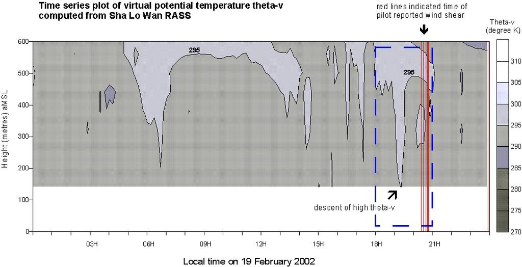
Reprint 850. Within the Eye of Typhoon Nuri in Hong Kong in C.P. Wong & P.W. Chan
 Reprint 850 Remote Sensing Observations of the Subsidence Zone Within the Eye of Typhoon Nuri in Hong Kong in 2008 C.P. Wong & P.W. Chan 8 th International Symposium on Tropospheric Profiling: Integration
GEN 3.5 METEOROLOGICAL SERVICES
 AIP GEN 3.5-1 GEN 3.5 METEOROLOGICAL SERVICES 1. RESPONSIBLE SERVICE The meteorological services for civil aviation at Jordan are provided by the Jordanian Meteorological Department. Postal Address: Director
Convective Structures in Clear-Air Echoes seen by a Weather Radar
 Convective Structures in Clear-Air Echoes seen by a Weather Radar Martin Hagen Deutsches Zentrum für Luft- und Raumfahrt Oberpfaffenhofen, Germany Weather Radar Weather radar are normally used to locate
ADL110B ADL120 ADL130 ADL140 How to use radar and strike images. Version
 ADL110B ADL120 ADL130 ADL140 How to use radar and strike images Version 1.00 22.08.2016 How to use radar and strike images 1 / 12 Revision 1.00-22.08.2016 WARNING: Like any information of the ADL in flight
Appendix X for CAP 437 Offshore Helicopter Landing Areas Guidance on Standards.
 Appendix X for CAP 437 Offshore Helicopter Landing Areas Guidance on Standards. Additional Guidance relating to the provision of Meteorological Information from Offshore Installations 1. Introduction This
A SMART SYSTEM FRAMEWORK ENABLING AN INNOVATIVE WEATHER AWARENESS SYSTEM FOR AIRPORTS AND BEYOND
 A SMART SYSTEM FRAMEWORK ENABLING AN INNOVATIVE WEATHER AWARENESS SYSTEM FOR AIRPORTS AND BEYOND Christian Schiefer, Sebastian Kauczok, Andre Weipert WSN16 WMO WWRP 4th International Symposium on Nowcasting
Remote Sensing of Windshear under Tropical Cyclone Conditions in Hong Kong
 Remote Sensing of Windshear under Tropical Cyclone Conditions in Hong Kong Dr H K Lam Director of the Hong Kong Observatory Permanent Representative of Hong Kong, China with WMO Vice-President of WMO Regional
Observing Weather: Making the Invisible Visible. Dr. Michael J. Passow
 Observing Weather: Making the Invisible Visible Dr. Michael J. Passow What Is Weather? Weather refers to the conditions of the atmosphere at a certain place and time. Weather differs from Climate, which
A Path to Shed Light on the Windshear. Enhancing the windshear alerting systems in airports by integrating a LiDAR-based system.
 DTN WHITE PAPER A Path to Shed Light on the Windshear Enhancing the windshear alerting systems in airports by integrating a LiDAR-based system August 2017 www.dtn.com / 1.800.509.8927 2017 DTN, Inc Summary
Fundamentals of Radar Display. Atmospheric Instrumentation
 Fundamentals of Radar Display Outline Fundamentals of Radar Display Scanning Strategies Basic Geometric Varieties WSR-88D Volume Coverage Patterns Classic Radar Displays and Signatures Precipitation Non-weather
A HIGH-RESOLUTION RAPIDLY-UPDATED METEOROLOGICAL DATA ANALYSIS SYSTEM FOR AVIATION APPLICATIONS
 A HIGH-RESOLUTION RAPIDLY-UPDATED METEOROLOGICAL DATA ANALYSIS SYSTEM FOR AVIATION APPLICATIONS C. S. Lau *, J. T. K. Wan and M. C. Chu Department of Physics, The Chinese University of Hong Kong, Hong
Marine Weather Primer
 1 of 73 Marine Weather Primer Mark A. Thornton LakeErieWX: Marine Weather Education and Forecasting Resources Mark@LakeErieWX.com 2 of 73 3 of 73 Marine Weather Seminars & Workshops Learn a little meteorology
FREEZING CONTAMINATION : AIRCRAFT ICING
 FREEZING CONTAMINATION : AIRCRAFT ICING PUTTING THE FORECASTS IN PLACE A transmission chain of adapted information SIGMET, AIRMET, GAMET, SIGWX charts PIREPS Awareness of the icing phenomena A few points
AUTOMATIC MONITORING OF BOUNDARY LAYER STRUCTURES WITH CEILOMETER ABSTRACT
 AUTOMATIC MONITORING OF BOUNDARY LAYER STRUCTURES WITH CEILOMETER Christoph Münkel 1, Reijo Roininen 1 Vaisala GmbH, Schnackenburgallee 1d, 55 Hamburg, Germany Phone +9 89 1, Fax +9 89 11, E-mail christoph.muenkel@vaisala.com
Name Date Class _. Please turn to the section titled The Nature of Light.
 Please turn to the section titled The Nature of Light. In this section, you will learn that light has both wave and particle characteristics. You will also see that visible light is just part of a wide
5.3 INVESTIGATION OF BOUNDARY LAYER STRUCTURES WITH CEILOMETER USING A NOVEL ROBUST ALGORITHM. Christoph Münkel * Vaisala GmbH, Hamburg, Germany
 5. INVESTIGATION OF BOUNDARY LAYER STRUCTURES WITH CEILOMETER USING A NOVEL ROBUST ALGORITHM Christoph Münkel * Vaisala GmbH, Hamburg, Germany Reijo Roininen Vaisala Oyj, Helsinki, Finland 1. INTRODUCTION
SEYCHELLES TECHNICAL STANDARDS
 SEYCHELLES TECHNICAL STANDARDS Aviation Meteorological Standards Seychelles Technical Standards Aviation Meteorological Standards Issue 01 July 2017 CONTENTS (general layout) FOREWORD Aviation Meteorological
BUFR Table D - List of common sequences
 BUFR Table D - List of common sequences Category of sequences 3 00 BUFR table entries sequences 3 01 Location and identification sequences 3 02 Meteorological sequences common to surface data 3 03 Meteorological
NINTH MEETING DISPLAY IN ATS UNITS. (Presented SUMMARY
 AMOFSG/9-SN No. 26 12/8/11 AERODROME METEOROLOGICAL OBSERVATION AND FORECAST STUDY GROUP (AMOFSG) NINTH MEETING Montréal, 26 to 30 September 2011 Agenda Item 6: MET informationn to support ATM UPDATING
Regional Hazardous Weather Advisory Centres (RHWACs)
") Regional Hazardous Weather Advisory Centres (RHWACs) The following outlines the criteria for the selection of RHWACs based on operational and functional requirements 1. Basic Principles The RHWAC must:
Regional Hazardous Weather Advisory Centres (RHWACs) The following outlines the criteria for the selection of RHWACs based on operational and functional requirements 1. Basic Principles The RHWAC must:
Gathering Weather Data
 1 Section 12. 2.3 3 Objectives State the importance of accurate weather data. Summarize the instruments used to collect weather data from Earth s surface. Analyze the strengths and weaknesses of weather
Implementation Guidance of Aeronautical Meteorological Forecaster Competency Standards
 Implementation Guidance of Aeronautical Meteorological Forecaster Competency Standards The following guidance is supplementary to the AMP competency Standards endorsed by Cg-16 in Geneva in May 2011. Implicit
A new lidar for water vapor and temperature measurements in the Atmospheric Boundary Layer
 A new lidar for water vapor and temperature measurements in the Atmospheric Boundary Layer M. Froidevaux 1, I. Serikov 2, S. Burgos 3, P. Ristori 1, V. Simeonov 1, H. Van den Bergh 1, and M.B. Parlange
Chapter 12: Meteorology
 Chapter 12: Meteorology Section 1: The Causes of Weather 1. Compare and contrast weather and climate. 2. Analyze how imbalances in the heating of Earth s surface create weather. 3. Describe how and where
WORLD AREA FORECAST SYSTEM OPERATIONS GROUP (WAFSOPSG)
") International Civil Aviation Organization WAFSOPSG/7-WP/10 5/7/12 WORKING PAPER WORLD AREA FORECAST SYSTEM OPERATIONS GROUP (WAFSOPSG) SEVENTH MEETING Lima, Peru, 17 to 21 September 2012 Agenda Item 6:
International Civil Aviation Organization WAFSOPSG/7-WP/10 5/7/12 WORKING PAPER WORLD AREA FORECAST SYSTEM OPERATIONS GROUP (WAFSOPSG) SEVENTH MEETING Lima, Peru, 17 to 21 September 2012 Agenda Item 6:
P13A.4 THE AIR FRANCE 358 INCIDENT OF 2 AUGUST 2005 AT TORONTO INTERNATIONAL AIRPORT. Paul Joe
 P13A.4 THE AIR FRANCE 358 INCIDENT OF 2 AUGUST 2005 AT TORONTO INTERNATIONAL AIRPORT Paul Joe Environment Canada, 4905 Dufferin St., Toronto, Ontario, CANADA M3H 5T4 email: paul.joe@ec.gc.ca tel: 416 739
Montréal, 7 to 18 July 2014
 INTERNATIONAL CIVIL AVIATION ORGANIZATION WORLD METEOROLOGICAL ORGANIZATION 6/5/14 Meteorology (MET) Divisional Meeting (2014) Commission for Aeronautical Meteorology Fifteenth Session Montréal, 7 to 18
Remote sensing of meteorological conditions at airports for air quality issues
 Remote sensing of meteorological conditions at airports for air quality issues Stefan Emeis, Klaus Schäfer Institute for Meteorology and Climate Research Atmospheric Environmental Research (IMK-IFU) Forschungszentrum
Quality assurance for sensors at the Deutscher Wetterdienst (DWD)
") Quality assurance for sensors at the Deutscher Wetterdienst (DWD) Quality assurance / maintenance / calibration Holger Dörschel, Dr Tilman Holfelder WMO International Conference on Automatic Weather Stations
Quality assurance for sensors at the Deutscher Wetterdienst (DWD) Quality assurance / maintenance / calibration Holger Dörschel, Dr Tilman Holfelder WMO International Conference on Automatic Weather Stations
Polarimetric Weather Radar by Selex ES Turn-key solutions and recent developments
 Polarimetric Weather Radar by Selex ES Turn-key solutions and recent developments R. Hannesen Radar workshop 2015 19+20 November 2015 Monash University, Melbourne ORGANISATION Company profile Recent technical
CHAPTER 13 WEATHER ANALYSIS AND FORECASTING MULTIPLE CHOICE QUESTIONS
 CHAPTER 13 WEATHER ANALYSIS AND FORECASTING MULTIPLE CHOICE QUESTIONS 1. The atmosphere is a continuous fluid that envelops the globe, so that weather observation, analysis, and forecasting require international
Final Weather Unit Study Guide
 Name: Atmospheric Composition and Layers Altitude Atmosphere Composition Troposphere Air Pressure Stratosphere Mesosphere Thermosphere Exosphere Ionosphere Sample Questions: Final Weather Unit Study Guide
P5.3 EVALUATION OF WIND ALGORITHMS FOR REPORTING WIND SPEED AND GUST FOR USE IN AIR TRAFFIC CONTROL TOWERS. Thomas A. Seliga 1 and David A.
 P5.3 EVALUATION OF WIND ALGORITHMS FOR REPORTING WIND SPEED AND GUST FOR USE IN AIR TRAFFIC CONTROL TOWERS Thomas A. Seliga 1 and David A. Hazen 2 1. Volpe National Transportation Systems Center, Cambridge,
Plan for operational nowcasting system implementation in Pulkovo airport (St. Petersburg, Russia)
") Plan for operational nowcasting system implementation in Pulkovo airport (St. Petersburg, Russia) Pulkovo airport (St. Petersburg, Russia) is one of the biggest airports in the Russian Federation (150
Plan for operational nowcasting system implementation in Pulkovo airport (St. Petersburg, Russia) Pulkovo airport (St. Petersburg, Russia) is one of the biggest airports in the Russian Federation (150
Atmospheric Lidar The Atmospheric Lidar (ATLID) is a high-spectral resolution lidar and will be the first of its type to be flown in space.
 is a high-spectral resolution lidar and will be the first of its type to be flown in space.") www.esa.int EarthCARE mission instruments ESA s EarthCARE satellite payload comprises four instruments: the Atmospheric Lidar, the Cloud Profiling Radar, the Multi-Spectral Imager and the Broad-Band Radiometer.
www.esa.int EarthCARE mission instruments ESA s EarthCARE satellite payload comprises four instruments: the Atmospheric Lidar, the Cloud Profiling Radar, the Multi-Spectral Imager and the Broad-Band Radiometer.
CIVIL AVIATION REQUIREMENTS SECTION 9 AIR SPACE AND AIR TRAFFIC MANAGEMENT. ISSUE II 24 th March, 2017 F. NO. AV.27077/1/2010-ANS
 GOVERNMENT OF INDIA OFFICE OF THE DIRECTOR GENERAL OF CIVIL AVIATION TECHNICAL CENTRE, OPP SAFDURJUNG AIRPORT, NEW DELHI CIVIL AVIATION REQUIREMENTS SECTION 9 AIR SPACE AND AIR TRAFFIC MANAGEMENT SERIES
Module 11: Meteorology Topic 3 Content: Weather Instruments Notes
 Introduction In order for meteorologists to accurately predict the weather, they take thousands of different weather measurements each day. Meteorologists need to use many tools in order to draw an accurate
Application of microwave radiometer and wind profiler data in the estimation of wind gust associated with intense convective weather
 Application of microwave radiometer and wind profiler data in the estimation of wind gust associated with intense convective weather P W Chan 1 and K H Wong 2 1 Hong Kong Observatory, 134A Nathan Road,
Weather Forecasting. March 26, 2009
 Weather Forecasting Chapter 13 March 26, 2009 Forecasting The process of inferring weather from a blend of data, understanding, climatology, and solutions of the governing equations Requires an analysis
AERODROME METEOROLOGICAL OBSERVATION AND FORECAST STUDY GROUP (AMOFSG)
") AMOFSG/9-SN No. 15 21/6/11 AERODROME METEOROLOGICAL OBSERVATION AND FORECAST STUDY GROUP (AMOFSG) NINTH MEETING Montréal, 26 to 30 September 2011 Agenda Item 5: Observing and forecasting at the aerodrome
AMOFSG/9-SN No. 15 21/6/11 AERODROME METEOROLOGICAL OBSERVATION AND FORECAST STUDY GROUP (AMOFSG) NINTH MEETING Montréal, 26 to 30 September 2011 Agenda Item 5: Observing and forecasting at the aerodrome
VISIBILITY SENSOR ACCURACY: WHAT S REALISTIC? John D. Crosby* EnviroTech Sensors, Inc. Clarksville, Maryland
 15.5 VISIBILITY SENSOR ACCURACY: WHAT S REALISTIC? John D. Crosby* EnviroTech Sensors, Inc. Clarksville, Maryland 1. INTRODUCTION Improvements in forward scatter-type visibility sensors in the past decade
Primary author: Tymvios, Filippos (CMS - Cyprus Meteorological Service, Dpt. of Aeronautical Meteorology),
,") Primary author: Tymvios, Filippos (CMS - Cyprus Meteorological Service, Dpt. of Aeronautical Meteorology), ftymvios@ms.moa.gov.cy Co-author: Marios Theophilou (Cyprus Meteorological Service, Climatology
Primary author: Tymvios, Filippos (CMS - Cyprus Meteorological Service, Dpt. of Aeronautical Meteorology), ftymvios@ms.moa.gov.cy Co-author: Marios Theophilou (Cyprus Meteorological Service, Climatology
Mechanical Turbulence Wind forms eddies as it blows around hanger, stands of trees or other obstructions
 Turbulence Low-level Turbulence below 15,000 feet consists of Mechanical Turbulence Convective Turbulence Frontal Turbulence Wake Turbulence Mechanical Turbulence Wind forms eddies as it blows around hanger,
Advances in weather and climate science
 Advances in weather and climate science Second ICAO Global Air Navigation Industry Symposium (GANIS/2) 11 to 13 December 2017, Montreal, Canada GREG BROCK Scientific Officer Aeronautical Meteorology Division
Chapter Introduction. Weather. Patterns. Forecasts Chapter Wrap-Up
 Chapter Introduction Lesson 1 Lesson 2 Lesson 3 Describing Weather Weather Patterns Weather Forecasts Chapter Wrap-Up How do scientists describe and predict weather? What do you think? Before you begin,
Weather vs. Climate. Tucson NWS homepage:
 Weather vs. Climate Tucson NWS homepage: www.nws.noaa.gov/twc/ A Weather Forecaster? Betty claims to know exactly when it s going to rain because her knee starts to hurt. Ms. Betty Martin of Newburgh,
Visibility and present weather sensors. you can trust... visibly better
 Visibility and present weather sensors you can trust... Biral HSS sensors visibly better CONTENTS HSS Application Examples PAGE 2 (this page) APPLICATION EXAMPLES 1 (Highway and Research) TRACK RECORD
MET 3502 Synoptic Meteorology. Lecture 5: Surface Weather Elements
 MET 3502 Synoptic Meteorology Lecture 5: Surface Weather Elements Surface Weather Elements Not observations of the surface, but Observations made by an observer (or instrument) at the surface Example:
Civil Aviation Authority of Nepal
 Civil Aviation Requirements For Meteorological Service for International Air Navigation CAR 3 First Edition - July, 2017 Civil Aviation Authority of Nepal Amendments Amendments and Corrigenda to these
BUFR Table D List of common sequences
 BUFR Table D List of common sequences F X Category of sequences Identifier NONE Category 01 Location and identification sequences (Temperature and humidity instrumentation) 3 01 130 0 03 002 Generic type
FORMATION OF AIR MASSES
 Chapter 24: Weather (air mass, fronts, Weather instruments, and forecasting the weather) Name: Period: Due Date: Air Mass Use the terms from the following list to complete the sentences below. Each term
Dynamics and Thermodynamics of Monsoon Cloud Systems Using Radars and Satellites
 Dynamics and Thermodynamics of Monsoon Cloud Systems Using Radars and Satellites Kusuma G Rao Space sciences Indian Space Research Organization Bangalore India 1.Patterns in Cloud systems organization-large
Christian Sutton. Microwave Water Radiometer measurements of tropospheric moisture. ATOC 5235 Remote Sensing Spring 2003
 Christian Sutton Microwave Water Radiometer measurements of tropospheric moisture ATOC 5235 Remote Sensing Spring 23 ABSTRACT The Microwave Water Radiometer (MWR) is a two channel microwave receiver used
Flight Dispatcher Aviation Meteorology Required Knowledge
 Flight Dispatcher Aviation Meteorology Required Knowledge 3.1 THE EARTH'S ATMOSPHERE 1 Properties 2 Vertical Structure 3 ICAO Standard Atmosphere 3.2 ATMOSPHERIC PRESSURE 1 Pressure Measurements 2 Station
CREX Table D List of common sequences
 Ver. 31.0.0 7 November 2018 CREX Table D List of common sequences Category of sequences D 00 CREX table entries sequences D 01 Location and identification sequences D 02 Meteorological sequences common
Mr. P s Science Test!
 WEATHER- 2017 Mr. P s Science Test! # Name Date 1. Draw and label a weather station model. (10 pts) 2. The is the layer of the atmosphere with our weather. 3. Meteorologists classify clouds in about different
Deutscher Wetterdienst
 WakeNet3-Greenwake Workshop Wake Vortex & Wind Monitoring Sensors in all weather conditions DWD s new Remote Wind Sensing Equipment for an Integrated Terminal Weather System (ITWS) Frank Lehrnickel Project
25.1 Air Masses. Section 25.1 Objectives
 Section 25.1 Objectives Explain how an air mass forms. List the four main types of air masses. Describe how air masses affect the weather of North America. Air Masses 25.1 Air Masses Differences in air
The first tropospheric wind profiler observations of a severe typhoon over a coastal area in South China
 The first tropospheric wind profiler observations of a severe typhoon over a coastal area in South China Lei Li, 1 Pak Wai Chan, 2 Honglong Yang, 1 Rong Zong, 1 Xia Mao, 1 Yin Jiang 1 and Hongbo Zhuang
A tail strike event of an aircraft due to terrain-induced wind shear at the Hong Kong International Airport
 METEOROLOGICAL APPLICATIONS Meteorol. Appl. 21: 504 511 (2014) Published online 14 March 2012 in Wiley Online Library (wileyonlinelibrary.com) DOI: 10.1002/met.1303 A tail strike event of an aircraft due
Weather is the of the Earth s atmosphere at a place and time. It is the movement of through the atmosphere o Energy comes from the
 Weather Notes Weather Weather is the of the Earth s atmosphere at a place and time It is the movement of through the atmosphere o Energy comes from the The sun is the force that weather The sun s energy
Your Source for Global Aviation Forecasts
 Your Source for Global Aviation Forecasts (831) 238-5054 100 Sky Park Drive Monterey, CA 93940 Weather4Cast.com Live Weather Data Feeds Weather4Cast.com provides Live Aviation Weather Data Feeds formatted
Data Short description Parameters to be used for analysis SYNOP. Surface observations by ships, oil rigs and moored buoys
 3.2 Observational Data 3.2.1 Data used in the analysis Data Short description Parameters to be used for analysis SYNOP Surface observations at fixed stations over land P,, T, Rh SHIP BUOY TEMP PILOT Aircraft
WORLD METEOROLOGICAL ORGANIZATION THE WMO TABLE DRIVEN CODES: THE 21 ST CENTURY UNIVERSAL OBSERVATION CODES
 WORLD METEOROLOGICAL ORGANIZATION THE WMO TABLE DRIVEN CODES: THE 21 ST CENTURY UNIVERSAL OBSERVATION CODES 1 THE WMO TABLE DRIVEN CODES: THE 21 ST CODES CENTURY UNIVERSAL OBSERVATION ABSTRACT The table
Clever Catch Weather Ball Question and Answer Sheets
 Clever Catch Weather Ball Question and Answer Sheets 1. Too much exposure to can cause skin cancer. B. Ultraviolet radiation 2. The layer of the atmosphere closest to the Earth s surface is the 3. Some
Unit 5 Lesson 3 How is Weather Predicted? Copyright Houghton Mifflin Harcourt Publishing Company
 Tracking the Weather Warm up 1 Why is it important to watch the weather forecast before traveling to another country? Tracking the Weather A meteorologist is a scientist who studies weather. Meteorologists
Chapter 12 Section 12.1 The causes of weather
 Chapter 12 Section 12.1 The causes of weather Main Idea: Air masses have different temperatures and amounts of moisture because of the uneven heating of earth's surface. What is Meteorology The study of
<Operational nowcasting systems in the framework of the 4-D MeteoCube>
 Background Nowcasting is applicable
Weather Forecasting Principles I
 Weather Forecasting Principles I Isaac Mugume Lecturer Notes MET 2202 April 6, 2017 Isaac Mugume (Mak) Lecture No.02 April 6, 2017 1 / 52 Review of Previous Lecture Isaac Mugume (Mak) Lecture No.02 April
Air Mass Thunderstorms. Air Mass Thunderstorms. Air Mass Thunderstorms. Lecture 26 Air Mass Thunderstorms and Lightning
 Lecture 26 and Lightning Life Cycle Environment Climatology Lightning 1 2 Short-lived, isolated thunderstorms that are not severe are often called air-mass thunderstorms. There are three stages describing
INTRODUCTION TO MICROWAVE REMOTE SENSING. Dr. A. Bhattacharya
 1 INTRODUCTION TO MICROWAVE REMOTE SENSING Dr. A. Bhattacharya Why Microwaves? More difficult than with optical imaging because the technology is more complicated and the image data recorded is more varied.
Astro 1050 Wed. Feb. 18, 2015
 Astro 1050 Wed. Feb. 18, 2015 Today: Begin Chapter 5: Light the Cosmic Messenger For Friday: Study for Test #1 Be sure to bring green bubble sheet, #2 pencil and a calculator. 1 Chapter 5: Light, the Cosmic
Observations needed for verification of additional forecast products
 Observations needed for verification of additional forecast products Clive Wilson ( & Marion Mittermaier) 12th Workshop on Meteorological Operational Systems, ECMWF, 2-6 November 2009 Additional forecast
SUMMARY. information from
 INTERNATIONAL CIVIL AVIATION ORGANIZATION WORLD METEOROLOGICAL ORGANIZATION MET/14-IP/ /16 2/6/14 English only Meteorology (MET) Divisional Meeting (2014) Commission for Aeronautical Meteorology Fifteenth
WLS70: A NEW COMPACT DOPPLER WIND LIDAR FOR BOUNDARY LAYER DYNAMIC STUDIES.
 WLS70: A NEW COMPACT DOPPLER WIND LIDAR FOR BOUNDARY LAYER DYNAMIC STUDIES. VALIDATION RESULTS AND INTERCOMPARISON IN THE FRAME OF THE 8TH CIMO-WMO CAMPAIGN. S. Lolli 1, L.Sauvage 1, M. Boquet 1, 1 Leosphere,
Series tore word. Acknowledgements
 Series tore word p. xi Preface p. xiii Acknowledgements p. xv Disclaimer p. xvii Introduction p. 1 The instrumental age p. 2 Measurements and the climate record p. 2 Clouds and rainfall p. 3 Standardisation
APPENDIX 2 OVERVIEW OF THE GLOBAL PRECIPITATION MEASUREMENT (GPM) AND THE TROPICAL RAINFALL MEASURING MISSION (TRMM) 2-1
 AND THE TROPICAL RAINFALL MEASURING MISSION (TRMM) 2-1") APPENDIX 2 OVERVIEW OF THE GLOBAL PRECIPITATION MEASUREMENT (GPM) AND THE TROPICAL RAINFALL MEASURING MISSION (TRMM) 2-1 1. Introduction Precipitation is one of most important environmental parameters.
APPENDIX 2 OVERVIEW OF THE GLOBAL PRECIPITATION MEASUREMENT (GPM) AND THE TROPICAL RAINFALL MEASURING MISSION (TRMM) 2-1 1. Introduction Precipitation is one of most important environmental parameters.
4 Forecasting Weather
 CHAPTER 16 4 Forecasting Weather SECTION Understanding Weather BEFORE YOU READ After you read this section, you should be able to answer these questions: What instruments are used to forecast weather?